Note: Descriptions are shown in the official language in which they were submitted.
CA 02936686 2016-07-13
WO 2015/107070 1 PCT/EP2015/050567
Mine control system
Background of the invention
The invention relates to a mine control system for monitoring the
excavation and other mine operations executed in a mine.
The field of the invention is defined more specifically in the inde-
pendent claim.
Mine vehicles are used in mines, which may be underground or sur-
face mines. The mine vehicle may be provided with one or more mine work
devices for performing determined mine work tasks at the mine. The mine ye-
hide may be a rock drilling rig, transport vehicle or a loader, for example.
Moni-
toring excavation and other mine work operations in large mines is complicat-
ed. At present, only scattering information about the mine and executed work
in the mine is provided, whereby it is difficult to get an overall view of the
mine.
Brief description of the invention
An object of the invention is to provide a novel and improved mine
control system, mine control unit, and method of controlling mine vehicles.
The mine control system according to the invention is characterized
by the features of independent apparatus claim.
The mine control unit according to the invention is characterized by
the features of another independent apparatus claim.
The method according to the invention is characterized by the fea-
tures of independent method claim.
An idea of the disclosed solution is that several mine vehicles oper-
ate in a mine and perform excavation or other mine operations. At least some
of the mine vehicles operating in the monitored mine are provided with on-
board monitoring means, whereby they may produce desired monitoring data
when performing their work tasks or moving in the mine. The mine vehicles
executing the monitoring may communicate with one or more mine control
units external to the mine vehicles by means of data communication means.
Thereby, the mine control unit receives the produced monitoring data from the
mine vehicles. The mine control unit is also provided with one or more mine
plans. Further, the mine control unit comprises suitable processing means and
programs in order to compare the received monitoring data with the mine plan
for determining the current state of the mine relative to the mine plan.
CA 02936686 2016-07-13
WO 2015/107070 2 PCT/EP2015/050567
An advantage of the disclosed solution is that the mine control sys-
tem is provided with needed monitoring data in order to produce an overall
view of the mine and to monitor development of the mine. Comparison of the
monitoring data to design data or stored data on previous situation provides
valuable information on progress and readiness of tunnels and mine spaces,
for example. The system also allows to ensure that excavation process of the
mine is done in accordance with the designed mine plan and set requirements.
Deviations may be notified at an early phase whereby corrective actions may
be performed without delay. The system may also allow ensuring that the mine
vehicles and other resources are utilized effectively. An additional advantage
of the monitoring system is that the situation determination of the mine may
be
carried out without a need for extensive and specialized surveying and meas-
uring infrastructure and equipment. A further advantage is that the procedure
does not need skilled workers and can be easily automated. Furnishing the
mine vehicles with monitoring means is easy and does not hamper the basic
operation of the mine vehicle in any way.
According to an embodiment, the mine control unit of the mine con-
trol system may be configured to receive monitoring data from any kind of mine
vehicles operating in the observed mine. The mine may comprise manually
controlled mine vehicles and autonomously operable mine vehicles. The man-
ually controlled mine vehicles may be remote controlled by operators, or alter-
natively the operators are on-board the mine vehicles. Thus, the disclosed so-
lution is suitable to any mine vehicles despite of their control system and de-
gree of automation. Furthermore, the mine vehicles may be different in struc-
ture as well as operationally. Thereby, the mine vehicle may be a rock
drilling
rig, bolting rig, transport vehicle, loading vehicle or measuring vehicle, for
ex-
ample. The mine vehicles of any kind may be provided with monitoring mod-
ules capable to monitor the operation of the mine vehicle and possibly also
having means allowing surveying of surroundings of the mine vehicle when
moving in the mine. Thus, the monitoring module may comprise one or more
measuring means such as sensors, measuring devices and scanning devices.
The monitoring module may also comprise one or more control units for con-
trolling operation of devices and systems of the module and for processing
produced and gathered measuring results. In addition to, the monitoring mod-
ule may comprise one or more data communication units for producing data
communication connection between the on-board module and the mine control
CA 02936686 2016-07-13
WO 2015/107070 3 PCT/EP2015/050567
unit of the mine control system. The data communication unit may also com-
municate with an on-board control unit of the mine vehicle and may transmit
data to one or more external terminal devices or serves. The monitoring mod-
ule may comprise fast coupling means so that the module is readily mountable
to any mine vehicle.
According to an embodiment, the mine plan comprises a 3D model
of the mine. The 3D model of the mine may comprise point cloud data in mine
coordinate system. Further, one or more mine vehicles are provided with
scanning devices for scanning surroundings of the mine vehicle in the mine for
producing point cloud data. The one or more mine vehicles further comprise
means for determining position of the mine vehicles in the mine coordinate
system, whereby the produced point cloud data is connected to the detected
data on position of the scanning in the mine coordinate system. The mine con-
trol unit is configured to receive the scanned data of the mine and to compare
the produced point cloud data with the 3D model of the mine. The disclosed
solution may implement a point cloud best fit method. The produced point
cloud data of the scanning devices and the 3D model of the mine may be uti-
lized in versatile manner, as will be disclosed below in this patent
application.
An advantage of the scanning technique is that it does not need any infrastruc-
ture to support the measurements. Further, the scanning provides statistical
certainty since the outcome may be based on several measurements because
of the fact that the measuring process is fast to execute.
According to an embodiment, the mine vehicles may be provided
with position detection means and scanning means. The mine plan of the mine
control unit comprises a 3D model of the mine. Thereby, the mine vehicle may
produce point cloud data and may compare the scanned point cloud data to
point cloud data of the mine plan. The mine control unit is provided with
suita-
ble programs, algorithms, processors and data processing means for detecting
in the scanning data new or changed surrounding point cloud objects at the
scanned position. Thereby, newly created or changed walls or other surfaces
of the mine are detected and recorded. The mine control unit may incorporate
the new point cloud data to the point cloud data of the realized 3D model of
the
mine. Thereby, the mine control unit may update the 3D model of the mine on
the basis of the received scanning data. Thanks to this embodiment, changes
in the mine are noted and may be taken into consideration. When the realized
3D model of the mine is up to date, reliable information about the mine may be
CA 02936686 2016-07-13
WO 2015/107070 4 PCT/EP2015/050567
used for several purposes, such as navigation, quality control, access control
and collision prevention.
According to an embodiment, the mine control unit is provided with
scanning data received from one or more mine vehicles. The mine control unit
may process the received scanning data by extracting point cloud data of the
surrounding surfaces and by removing point cloud data of all the other
objects,
such as people and other mine vehicles. Thus, a simplified point cloud data of
the surrounding surfaces may be created. Thanks to the simplified point cloud
data, storing and handling of the data is facilitated. Size of a data package
of
the simplified point cloud data may be smaller and the data does not include
unnecessary information.
According to an embodiment, the mine control unit may produce a
simplified point cloud data of the surrounding surfaces, as it is disclosed in
the
previous paragraph. Furthermore, the mine control unit may compare the new
simplified point cloud data with the point cloud data of the 3D model of the
mine. Based on the comparison of the point clouds, the mine control unit may
update the 3D model of the mine by incorporating the simplified point cloud
data to the realized 3D model of the mine. Thanks to the simplified point
cloud
data, no irrelevant data is incorporated to the 3D model of the mine. The up-
dated 3D model may be used for any purpose.
According to an embodiment, the mine plan of the mine control unit
defines development of rock cavities in several succeeding rounds, which are
drilled and blasted. Thus, new rock cavity sections corresponding to the
lengths of the rounds are formed in each round. A mine vehicle provided with
the scanning device is configured to enter the new rock cavity section, deter-
mine position of the mine vehicle at the new section and then execute scan-
ning of surfaces of the new rock cavity section for producing point cloud data
on the developed surfaces. The mine control unit is configured to receive the
scanned data of the developed new rock cavity sections. The mine control unit
may incorporate the point cloud data to the 3D model of the mine in order to
updating the realized 3D model of the mine. In this embodiment the mine vehi-
cles entering the new rock cavity sections may serve as mobile surveying de-
vices whereby no conventional manual surveying is needed. The use of the
disclosed mobile surveying improves safety when compared to conventional
manual surveying of the mine.
CA 02936686 2016-07-13
WO 2015/107070 5 PCT/EP2015/050567
According to an embodiment, one or more of the mine vehicles op-
erating in the mine are provided with scanning devices for producing point
cloud data of the surroundings of the mine vehicles, when desired. The mine
vehicle provided with the scanning means also comprises an on-board control
unit provided with a 3D model of the mine. The onboard control device re-
ceives the scanned data from the scanning device and compares the produced
point cloud data with the 3D model of the mine for detecting deviations be-
tween them. The on-board control device is provided with needed point cloud
matching and processing means for executing the comparison. When the on-
board control unit of the mine vehicle recognizes deviations in the comparison
process, the on-board control unit may transmit only the detected deviating
point cloud data to the mine control unit. The mine control unit may utilize
the
received data when determining the current state of the mine. In this embodi-
ment the scanned point cloud data is pre-processed already in the mine vehi-
cle and only the relevant data is communicated to the mine control unit. This
way unnecessary loading of the data communication and processing means
may be avoided. On the other hand, the scanning may be executed as often
as needed, or even continuously, without the risk of overloading the system.
In
a detailed additional embodiment, the on-board control unit is provided with a
realized 3D model of the mine and the on-board control unit is configured to
compare the scanned point cloud data to the latest point cloud data of the
real-
ized 3D model of the mine in order to detect deviating portions between them.
If the on-board control unit detects deviations between the point clouds, it
may
record the deviating data and may update the realized 3D model of the on-
board control unit. The on-board control unit may also send the deviating data
to the mine control unit, which may update the realized 3D model of the mine
control unit. Further, in an alternative additional embodiment, the on-board
control unit of the mine vehicle is provided with 3D model of the planned
mine.
The produced scanning data is compared to the designed mine model and
when deviations between the realized mine and the designed mine model are
detected, the deviations are communicated to the mine control unit. This way
it
is possible to inform the mine control unit about over and under excavation
situations, as well as other quality problems in the excavation process. All
in
all, the embodiments disclosed in this paragraph help avoiding unnecessary
transmission of data, and still, the produced data on the realized mine and
CA 02936686 2016-07-13
WO 2015/107070 6 PCT/EP2015/050567
quality of the excavation process is effectively provided for updating the
current
state of the mine.
According to an embodiment, one or more of the mine vehicles pro-
vided with the scanning device are configured to execute the scanning each
time the mine vehicles are stopped. This way, scanning of the mine may be
automated and scanning data may be produced repeatedly, whereby devia-
tions may be noted without delays. In order to avoid heavy data transmission
and processing it is possible pre-process the scanned data in one or more on-
board control units and to transmit to the mine control unit only relevant
infor-
mation relating to detected changed or new point clouds.
According to an embodiment, the mine vehicle provided with the
scanning device and/or other monitoring means is serving as a mobile survey-
ing device. The mine vehicle may execute the surveying continuously when
executing dedicated normal operations of the mine vehicle. If the mine vehicle
is a rock drilling rig or a reinforcing rig, it may scan the surroundings when
it
stops at a work site for executing drilling or feeding reinforcing elements or
ma-
terial. It may also be defined that the scanning is executed at least once
each
time when the mine vehicle is not moving. Thanks to this procedure, the mine
may be surveyed repeatedly and in parallel to the normal operational process
without any need for extra resources. The 3D model of the mine may thus be
accurate and updated.
According to an embodiment, the system comprises several rock
drilling rigs each of them being provided with the scanning devices.
According to an embodiment, all the mine vehicles of the system are
provided with the scanning devices.
According to an embodiment, position of the at least one mine vehi-
cle in the mine coordinate system is determined by means of scanning the sur-
rounding surfaces of the mine vehicle for producing point cloud data and exe-
cuting a point cloud matching program for fitting the produced point cloud
data
to point cloud data of the 3D model of the mine. An advantage of this embodi-
ment is that the mine vehicle and the mine need not to be provided with any
other position measuring devices or infrastructure. However, in some cases
the position detection based on scanning and point cloud matching procedure
may also be used in combination with conventional measuring techniques.
According to an embodiment, position of the mine vehicle is deter-
mined by utilizing scanning and point cloud processing and matching tech-
CA 02936686 2016-07-13
WO 2015/107070 7 PCT/EP2015/050567
niques. In order to facilitate processing of point clouds, the mine control
system
utilizes only part of the point cloud data of the mine in the comparison
process.
Then, the mine control system may be configured to determine an area or sec-
tion of the mine where the monitored mine vehicle is currently operating, and
based on the position data, the system may compare the produced point cloud
data to partial point cloud data of the mine. Thus, the comparison is not made
to the whole 3D model of the mine plan, but instead the scanned point cloud
data is compared only to a section of the mine where the mine vehicle is oper-
ating at the time of the monitoring. An advantage of this solution is that the
amount of the data processed during the comparison is minor, whereby less
calculation capacity is needed and processing time may be shorter.
According to an embodiment, the mine control system is provided
with position data of one or more mine vehicles. The position of the mine vehi-
cle in the mine coordinate system is determined by means of conventional po-
sition measuring devices or sensors on-board, or by utilizing detection of one
or more position identifiers or markings arranged in the mine. Alternatively,
positioning may be done by receiving radio signals and may then be based on
RFID or WLAN positioning, for example. Further, the position of the mine vehi-
cle may be determined by means of a laser measuring device or tachymeter.
Thus, any suitable measuring system or device may be utilized for producing
the needed data on position and direction of the mine vehicle. The position
sensing and detection means may be arranged to a monitoring module or di-
rectly to the mine vehicle.
According to an embodiment, the mine control unit is configured to
receive position data from the mine vehicles and is configured to visualize
the
positions of the mine vehicles on at least display device, thereby providing
up-
dated fleet management data. The positions of the operating mine vehicles in
the mine is also valuable information about the current situation of the mine.
Based on the position data, excavation and other mine work tasks may be con-
trolled effectively.
According to an embodiment, the mine control unit is configured to
indicate deviations between the mine plan and detected realized rock surfaces
on the basis of the monitoring data. Based on the detected deviations, the
mine control unit may produce data on quality of the excavation process in one
or more sections of the mine. The deviating parts of the mine and other
quality
problems may be shown on a display device, for example. The system may be
CA 02936686 2016-07-13
WO 2015/107070 8 PCT/EP2015/050567
arranged to examine profile quality of the surfaces of the realized mine, suc-
cess of blasts, as well as over and under excavated surfaces or mine sections.
According to an embodiment, the mine control system is configured
to monitor quality of the excavation process and to detect changed and new
portions of the mine. The mine control unit is configured to indicate the
changed and deviating portions of the mine for an operator. The mine control
system may comprise a control room provided with one or more display devic-
es. The updated data may be displayed on the display device with special
markings or colors. Thus, supervision is facilitated. The system also
facilitates
producing different quality reports and other documentation. Further, the sys-
tem allows storing data on the excavation process and reinforcing procedures
of the excavated rock caverns.
According to an embodiment, the mine control system is provided
with a mine plan comprising a designed tunnel line and profile of a tunnel or
rock cavity to be excavated. The tunnel profile determines inner surfaces of
the
tunnel along the tunnel line. The tunnel, as well as other rock cavities and
spaces, may have the predesigned tunnel line defining the direction of the
space to be excavated. The tunnel line may be a central line of the tunnel or
rock cavity. Further, the tunnel and other rock spaces may have predesigned
profile defining contour of the space to be excavated. In addition to
theoretical
excavation profile the mine plan may determine allowed tolerances for the the-
oretical excavation profile. Thereby, the mine plan may also comprise mini-
mum and maximum profiles. The mine control system may compare the real-
ized tunnels to the designed tunnel data and may then determine the current
state of the tunnels and the mine. The system may also detect deviations in
the excavated spaces and may create quality data on the excavation process.
According to an embodiment, the mine control system is provided
with a mine plan comprising a plurality of drilling patterns defining
positions
and directions of drill holes for rounds to be drilled at predetermined
locations
in the mine. In order to determine the state of the mine the mine control unit
retrieves or receives data on the realized rounds being excavated and com-
pares the real data to the design data for detecting deviations and producing
quality data on the excavation process of the rounds.
According to an embodiment, the mine control system is provided
with a mine plan determining excavation of at least one rock cavity in several
successive rounds which are located at a distance from each other along a
CA 02936686 2016-07-13
WO 2015/107070 9 PCT/EP2015/050567
planned central line of the rock cavity and wherein each round is provided
with
several drill holes to be drilled on a drilling surface of the round. Further,
at
least one mine vehicle provided with on-board monitoring means is configured
to determine realized positions of the rounds and is configured to transmit
the
determined position data to the mine control unit. The mine control unit is
con-
figured to determine realized advance of the excavation of the rock cavity by
detecting the position of the recent round. The determined realized advance
may provide information about success of the excavation process. The data
may be taken into consideration by modifying drilling patterns and charging
plans, for example.
According to an embodiment, a tunnel or rock cavity of the moni-
tored mine is excavated by utilizing face drilling, wherein start points of
the drill
holes to be drilled are on a bottom face of a tunnel or other rock cavity. The
mine control unit may determine realized advance of the excavation of the rock
cavity by detecting the position of the face of the recent round. The
determined
realized advance may provide information about success of the excavation
process, and may be taken into consideration when drilling and charging the
following rounds. The advance of the excavation work in tunneling and drifting
may also be called pull per round or yield per round.
According to an embodiment, one or more tunnels or rock cavities of
the monitored mine are excavated by utilizing fan drilling, wherein start
points
of the drill holes to be drilled are on an inner surface of preformed pilot
tunnels
or cavities. In other words, the drill holes are drilled on contour surfaces
of the
cavities and the cavities are enlarged by blasting the drill holes after being
charged. The mine control unit may determine realized advance of the excava-
tion of the one or more rock cavities by detecting positions of the drilled
and
blasted fans, or alternatively by detecting realized face surfaces of the
rounds
in the direction of the tunnel lines.
According to an embodiment, one or more mine vehicles of the sys-
tem are provided with on-board monitoring means for determining realized po-
sitions of two consecutive rounds. The detected position data may be transmit-
ted to the mine control unit, which may determine realized advance of the
round by detecting distances between the two rounds. Further, the mine con-
trol unit may compare the determined length of the round to the planned length
of the round and may indicate detected deviations. This way it is possible to
CA 02936686 2016-07-13
WO 2015/107070 10 PCT/EP2015/050567
monitor success of the excavation process and to make needed amendments
to parameters of the process.
According to an embodiment, one or more mine vehicles of the sys-
tem are configured to determine realized profile of the round by means of mon-
itoring means and may transmit the determined profile to the mine control
unit.
The detected profile of the round defines the realized surfaces limiting the
cre-
ated space. In other words, profile along advance of the round is determined.
The surface profiles of the round may be determined by scanning means, for
example. The scanned profile may comprise point cloud data and position data
of the points in a mine coordinate system.
According to an embodiment, the mine control unit is configured to
determine volume of the blasted rock material in one round, or alternatively,
in
two or more successive rounds. The detected volume data may be utilized in
determining the state of the mine. The mine control unit determines volume of
the at least one excavated round by means of the detected advance of the
round and the detected profile of the round. In other words, the mine control
unit may calculate the excavated volume based on information about advance
and one or more profiles along the new advance. The defined volume may
comprise combined volumes of several consecutive rounds, in case advance
of each round is not measured individually. Thus, the measurements may be
performed at desired intervals, whereby the combined advance is determined
after excavation of two or more consecutive rounds.
According to an embodiment, the mine control unit is provided with
sensed data on realized profile of one or more rounds. The mine plan compris-
es data on planned profiles for the rounds. Then, the mine control unit may
compare the realized profile of the round to the planned profile determined in
the mine plan and may indicate detected deviations between the profiles.
Thereby, the system may determine the state of at least one section of the
mine on the basis of the disclosed profile comparison.
According to an embodiment, the mine control unit is provided with
a mine plan comprising planned shapes for bottoms of the rounds to be exca-
vated. The shapes of the bottoms are affected by drilling patterns and
charging
patterns or plans designed for the rounds to be drilled and blasted. The mine
control unit is configured to compare the detected realized face profiles to
the
designed shapes of the bottoms of the rounds in order to examining success of
blasts of the rounds. The disclosed solution may be utilized to detect
deviating
CA 02936686 2016-07-13
WO 2015/107070 11 PCT/EP2015/050567
face profiles and reasons for causing the deviations. The executed drilling
pat-
tern and positions of start and end points of the drill holes of the drilling
pattern
may be compared to the scanned or otherwise detected realized surface
shape of the bottom of the round after being blasted. The results of the com-
parison may be utilized for analyzing reasons for the detected deviation.
Thus,
it may be possible to notify if the deviations are caused by defective
drilling or
drilling pattern, or by the excavated rock conditions, for example.
According to an embodiment, drill hole data and calculated profile
and/or shape based on the drill hole data is compared to sensed data of real-
ized surfaces and shapes of the excavated round. Thus, the mine control unit
may be configured to receive drill hole data of the drilled holes of the round
from at least one rock drilling rig. The rock drilling rig may measure the
drill
hole data during drilling and may send the data to the mine control unit, or
may
alternatively pre-process the data in an on-board control unit. The drill hole
data may comprise start points and ends points of the drilled holes, as well
as
directional angles and lengths of the realized holes. Based on the recorded
data, the control unit may determine calculated profile data of the round. Tun-
nel profile of the round may be calculated by means of positions of end points
of an outermost drill hole row of the round, for example. Then, the calculated
tunnel profile may be compared to the realized profile data in the control
unit,
whereby deviations between the realized tunnel data and the data based on
drilling data may be detected. The realized tunnel data may be determined by
means of the scanning means, for example. In addition to the tunnel profile,
or
alternatively, volume and 3D ¨shape of the round may be calculated on the
basis of the realized drill hole data and may be compared to the scanned data
of the realized surfaces of the excavated round. The results of the comparison
may be utilized for analyzing reasons for the detected deviation. Thus, it may
be possible to notify if the deviations are caused by defective drilling or
drilling
pattern, or by rock conditions or geological issues of the excavated rock, for
example.
According to an embodiment, the mine control unit is provided with
a mine plan comprising theoretical profiles for the rock cavities to be
excavat-
ed. The mine control unit is further provided with monitoring data relating to
the
shapes of the developed rock cavities. The mine control unit compares the de-
termined realized profiles of the surfaces of the excavated rock cavities to
the
theoretical profiles of the mine plan and indicates possible over excavations
or
CA 02936686 2016-07-13
WO 2015/107070 12 PCT/EP2015/050567
under excavations relative to the input theoretical profiles. Thus, the mine
con-
trol system may produce data on quality of the excavation. The current state
of
the mine may comprise information about the mentioned over and under exca-
vations, for example.
According to an embodiment, the mine control unit is provided with
monitoring data on one or more realized rounds. The mine control unit may be
provided position and profile of the round. Thus, the position of the face of
the
round and the profile of the round may be determined by means of a rock drill-
ing rig provided with the monitoring means. The measuring data may be
transmitted to the mine control unit. The rock drilling rig may be provided
with
one or more scanning devices for measuring the round. Alternatively, conven-
tional measuring sensors or devices may be used. A boom of the rock drilling
rig may be instrumented and may be used for executing the needed face posi-
tion and round profile measurements. This embodiment allows the face at the
bottom of a tunnel or corresponding rock space to be determined and the pro-
file of the round to be determined. The determined data may be taken into
consideration when determining quality of the excavation process and when
updating the state of the mine.
According to an embodiment, the rock drilling rig is provided with at
least one scanning device for scanning the surroundings. Then, the position of
the rock drilling rig in the mine is determined by scanning the surroundings
for
producing point cloud data and by executing point cloud matching with the
point cloud data of the 3D mine model a mine coordinate system. In this em-
bodiment the mine control system is provided with a mine plan comprising 3D
model of the mine and the position of the rock drilling rig in the mine
coordinate
system is determined in at least one control unit. The point cloud matching
process may be executed in a control unit of a scanning module, in a control
unit of a rock drilling or in a mine control unit. The control units may be
provid-
ed with processors for executing the needed programs. Since the position of
the rock drilling rig is determined in the mine coordinate system the position
is
also known in the mine plan, as well as position of the round and position of
the face of the round.
According to an embodiment, the rock drilling rig is provided with a
scanning device configured to detect distance between the carrier and the face
of a bottom of a round. Thus, the realized position of the face relative to
the
carrier may be determined quickly and when needed.
CA 02936686 2016-07-13
WO 2015/107070 13 PCT/EP2015/050567
According to an embodiment, the rock drilling rig is provided with the
scanning device allowing scanning in a tunnel line direction towards the face
at
the bottom of the tunnel or corresponding rock cavity. The scanning produces
point cloud data provided with coordinates in the mine coordinate system. At
least one control unit is configured execute point cloud processing program or
algorithm for detecting the greatest depth in the tunnel line towards the face
at
the bottom of the tunnel or rock cavity. Then the realized position of the
face
may be determined in the mine coordinate system.
According to an embodiment, scanning and point cloud processing
techniques and the produced point cloud data disclosed in the previous em-
bodiments may also be utilized to produce the surface profile of the face at
the
bottom end of the tunnel or rock cavity. Thereby, the realized surface profile
of
the previously blasted round and the created rock surface may be determined.
This data may be used to determine quality of the drilling and charging, for
ex-
ample. The data may also be utilized to adjust drilling patterns and charging
plans. The surface profile of the face may also be called topography of the
face.
According to an embodiment, the mine control system is arranged to
receive monitoring data from one or more rock drilling rigs comprising one or
more booms. The boom may comprise a feed beam at the distal end portion of
the boom. The boom is instrumented and the relative location between the car-
rier and the face is determined by arranging the feed beam or a mining work
device in contact with the face and determining the location by means of the
instrumented boom. The boom may comprise one or more sensors or measur-
ing devices, for determining position and direction of the boom relative to a
carrier of the mine vehicle. The boom may comprise two or more boom parts
and joints between the boom parts. The joints may be provided with angle
measuring devices, for example. Furthermore, between the boom and carrier,
and between the boom and the feed beam may also be suitable sensors.
According to an embodiment, the mine control system is arranged to
receive monitoring data from one or more rock drilling rigs comprising one or
more booms provided with feed beams and mine work devices supported to
the feed beams. Position and direction of the feed beam or the mining work
device arranged in connection with the feed beam is determined by utilizing
scanning technique. Then, the surroundings of the rock drilling rig is scanned
and a monitored object, such as the feed or the mine work device, is inside a
CA 02936686 2016-07-13
WO 2015/107070 14 PCT/EP2015/050567
reach area of a scanning device arranged on the mine vehicle. At least one
control unit is provided with reference data, such as point cloud data of the
monitored object. The control unit may be in connection with the scanning de-
vice. A point cloud processing program is executed in the control unit and the
monitored object is searched from the point cloud data of the surroundings.
The points of the point cloud comprise coordinate data whereby the control
unit
may determine position and direction of the monitored object. Thus, in this em-
bodiment position of the monitored object, such as the feed beam or the mine
work device, is searched from the scanned point cloud data by means of a
point cloud matching program and the reference point cloud data of the moni-
tored object. After match is found between the points of the produced point
cloud and the reference point cloud, coordinates of the matching points may be
determined. Thereafter the position and direction of the monitored object may
be determined. The boom may be without any sensors or measuring devices,
when the disclosed positioning determination is used, or alternatively, the
boom may be instrumented and may comprise conventional sensors, whereby
both scanning means and sensors may be used. When the scanning tech-
nique is used together with the conventional joint measurement techniques,
some of the joint sensor may be removed. To sum up, the disclosed solution
may allow removal of all sensors in the boom of the rock drilling rig and may
still give accurate position and angle information for drilled holes or
installed
rock reinforcing bolts. The disclosed system may also avoid a need for any
compensation model needed for deflection of the boom.
According to an embodiment, the mine control system is part of a
control room product configured to visualize the at least one monitored
feature
on at least one display device. The system may provide visualization of the
entire mine in a control room. With the real scanned model of the mine, the
fleet management system may show the mine as it is and also including the
locations of the mine vehicles in the realized model.
According to an embodiment, the mine control system comprises at
least one server allowing monitoring data to be distributed to one or more ter-
minal device via a data connection.
According to an embodiment, the mine control system is part of a
control room product comprising a fleet managing feature monitoring the posi-
tions of all or selected mine vehicles. The system may also monitor current
positions of selected or all mine vehicles operating in a selected observation
CA 02936686 2016-07-13
WO 2015/107070 15 PCT/EP2015/050567
area of the mine. Further, the system may monitor drilling and bolting rigs
and
may determine and record position and directions of drill holes currently
influ-
enced by the mine work devices of the monitored rigs.
According to an embodiment, the mine control system is part of a
control room product comprising a fleet managing feature monitoring the oper-
ating status of all or selected mine vehicles. The system may also monitor cur-
rent status of the mine vehicles operating in a selected observation area. Fur-
ther, the system may monitor estimated remaining duration of the current work
task of the mine vehicle or the mine work device.
According to an embodiment, the mine control system is part of a
control room product comprising a fleet managing feature monitoring the oper-
ating condition and maintenance need for all or selected mine vehicles.
According to an embodiment, the mine control system is part of a
control room product comprising a fleet managing feature monitoring a general
status of one or more mine vehicles and one or more mine work devices.
According to an embodiment, the mine control system is configured
to visualize the at least one monitored feature on at least one display
device.
According to an embodiment the mine control system comprises at
least one server allowing monitoring data to be distributed to one or more ter-
minal device via a data connection.
According to an embodiment, the mine vehicle comprises at least
one data communication device allowing data communication between a con-
trol unit on-board and a mine control system. The data communication may be
based on any wireless data transfer technique. The mine may be provided with
a wireless network utilizing radio wave signals. The data transmission may be
based on a wireless local area network (WLAN), for example.
According to an embodiment, the mine control system may com-
prise one or more computers or control units external to the mine and mine
vehicle. Alternatively, the mine control system may comprise one or more
servers allowing access to electrical terminal devices for retrieving the data
transmitted from the control unit where the monitoring data in analyzed. The
mine control unit may also be considered to mean other data communication
and distribution means allowing access to the processed data.
According to an embodiment, the mine vehicle is provided with a
monitoring module comprising a frame, one or more monitoring means and
one or more data transmission devices or units. The monitoring module may
CA 02936686 2016-07-13
WO 2015/107070 16 PCT/EP2015/050567
communicate with the mine control unit by means of the data transmission de-
vice. The monitoring means may comprise a scanning device and/or one or
more other measuring and sensing devices. The monitoring module may also
comprise one or more control units provided with processors and needed
computer programs and algorithms for processing the produced monitoring
data. The monitoring module may be designed so that it is mountable to any
mine vehicle.
According to an embodiment, the scanning device is a laser scan-
ner.
lo According to an embodiment, the scanning device comprises at
least one camera. The scanning device may be based on stereo vision system
comprising at least two cameras. Alternatively, the scanning may be based on
a technology known as a depth from focus ¨system, wherein one camera is
used and the method basically works by taking a focus stack of an object, and
then analyzing the luminance of each pixel in relation to its neighbors. The
control unit may be provided with image processing system for processing data
received from the one or more cameras.
According to an embodiment, the scanning device comprises in ad-
dition to the scanning unit at least one camera for recording color
information
of the scanned obstacles. The recorded color information may be connected to
the scanned point cloud data. This way additional information may be gath-
ered.
According to an embodiment, the 3D scanning data is obtained by
round trip time of flight of a laser that is swept across measured surface or
ob-
ject. This type of remote sensing technique is also known as LiDAR (Light De-
tection And Ranging).
According to an embodiment, the 3D scanning data is obtained by
round trip time of flight of single (modulated) light source and the return
times
of reflections from different parts of the measured surface or object. This
type
of remote sensing technique is also known as ToF (Time of Flight). In this em-
bodiment ToF -cameras may be used.
According to an embodiment, the 3D scanning data is obtained by
geometry of a known pattern of light projected to the measured surface or ob-
ject shown in one or more camera images. This type of 3D scanning is also
known as a structured light 3D scanning technique.
CA 02936686 2016-07-13
WO 2015/107070 17 PCT/EP2015/050567
According to an embodiment, the 3D scanning data is obtained by
analysis of multiple pictures taken of same target from different points of
view.
In this embodiment a stereo camera system may be exploited. The control unit
may be provided with an image processing system for processing image data
received from the two or more cameras.
According to an embodiment, the fastening unit of the scanning de-
vice comprises fast coupling means whereby the scanning device is readily
mountable and dismountable to the mine vehicle. The fast coupling means
may comprise at least one magnetic coupling element.
lo According to an embodiment, the mine is an underground mine. The
underground mine comprises an underground rock space, such as a tunnel,
cavern or a storage hall.
According to an embodiment, the mine is a surface mine comprising
obstacles on the surface. The surface mine may be an opencast mine.
According to an embodiment, a mine control unit for controlling sev-
eral mine vehicles comprises connection means for being in operational com-
munication with the several mine vehicles, receiving means for receiving moni-
toring data from the several mine vehicles and processing means for pro-
cessing data, and the mine control unit is provided with a mine plan, the mine
control unit is configured to receive monitoring data from the several mine ve-
hicles, and the mine control unit is configured to compare the received
monitor-
ing data with the mine plan for determining the current state of the mine rela-
tive to the mine plan.
The disclosed mine vehicle may be utilized when implementing the
disclosed mine control system and mapping method. The detailed embodi-
ments, which are disclosed in connections to the mine control system and the
mine vehicles, also relate to the method, and vice versa.
The above-disclosed embodiments can be combined to form suita-
ble solutions provided with necessary features disclosed.
Brief description of the figures
Some embodiments are described in more detail in the accompany-
ing drawings, in which
Figure 1 is a side view of a rock drilling rig provided with scanning
and monitoring means,
CA 02936686 2016-07-13
WO 2015/107070 1 8 PCT/EP2015/050567
Figure 2 shows schematically a principle of scanning surfaces and
physical obstacles surrounding a mine vehicle,
Figure 3 is a schematic side view of a scanning module arranged on
a carrier of a mine vehicle,
Figure 4 is a schematic view of a basic principle of point cloud
matching utilized when processing scanning results,
Figure 5 is a schematic and strongly simplified view of a process de-
tecting new or changed surfaces of a mine, and incorporating the detected de-
viating point cloud data after matching scanned data with a reference data,
Figure 6 is a schematic and strongly simplified view of an updated
reference point cloud data, which incorporates detected new scanned points,
Figure 7 is a schematic diagram showing related elements, pro-
cessing means and features of a control unit being able to process point cloud
data,
Figure 8 is a diagram showing some features relating to the current
state of the mine,
Figure 9 is a diagram showing feasible quality data of the mine de-
termined by the mine control system,
Figure 10 is a diagram showing feasible data included in the mine
plan and being input to the mine control unit,
Figure 11 is a diagram showing a feasible embodiment of a mine
control system and related means and elements,
Figure 12 is a schematic and strongly simplified view of a mine
comprising several tunnels and different mine vehicles operating in tunnels,
Figure 13 is a schematic view showing principles of fan drilling and
face drilling methods, and
Figure 14 is a schematic view showing quality problems in tunnel
profile caused by inaccurate drilling of blast holes.
For the sake of clarity, the figures show some embodiments of the
disclosed solution in a simplified manner. In the figures, like reference
numer-
als identify like elements.
Detailed description of some embodiments
Figure 1 shows a rock drilling rig 1 as an example of a mine vehicle.
Also rock bolting rigs, charging rigs, measuring vehicles, transport vehicles
and
loading vehicles are mine vehicles. Thus, the mine vehicles may be provided
with mine work devices such as rock drilling units, bolting units, charging
units,
CA 02936686 2016-07-13
WO 2015/107070 19 PCT/EP2015/050567
loading units and load carrying units, as it is shown in Figure 12. The
disclosed
solution may be applied for all type mine vehicles.
The rock drilling rig 1 may comprise a movable carrier 2 and one or
more booms 3 connected to the carrier 2. At a distal end portion of the boom 3
may be a drilling unit 4. The drilling unit 4 may comprise a feed beam 5 and a
rock drilling machine 6 supported on it. The rock drilling machine 6 may com-
prise a shank at a front end of the rock drilling machine 6 for connecting a
tool
7. At least one boom 3 may comprise a mine work device other than the drilling
unit. Thus, the mine work device may be a rock bolting unit or a charging
unit,
for example.
In Figure 1 the rock drilling rig 1 is operating in an underground
mine space 8, which may be a tunnel, storage hall or corridor, for example.
The mine space 8 may comprise an end face surface 9, wall surfaces 10 and a
roof surface 11. The rock drilling rig 1 is provided with one or more scanning
devices S for measuring surroundings of the rock drilling rig 1. The scanning
device S may scan 360 and may thus measure the surrounding surfaces and
other obstacles around the rock drilling rig 1 and produce scanning data for
the
system. The scanning device S may comprise a laser scanner, a camera or
any other device capable of producing point cloud data. The scanning device S
may be placed on the carrier 2.
The scanning device S may be placed in a known position on the
mine vehicle. Then coordinates of the scanning device are known in machine
coordinates system 12 of the mine vehicle. The scanning device sees around
and may then detect also one or more objects, parts or components of the
mine vehicle as well.
Alternatively, the position of the scanning device S need not be ac-
curately predetermined and calibrated when the disclosed system utilizes point
cloud matching techniques. Then, at least one reference component or object
of the rock drilling rig is detected in the scanning data and produced point
cloud data of the detected object is utilized in determination of relative
position
of the scanning device S on the carrier 2.
The rock drilling rig 1 has a machine coordinate system 12 and the
mine has a mine coordinate system 13. On-board the rock drilling rig 1 may be
one or more control units 14a for receiving scanning data, performing point
cloud matching and searching measures, producing position data and execut-
CA 02936686 2016-07-13
WO 2015/107070 20 PCT/EP2015/050567
ing needed coordinate transformations according to principles disclosed in
this
patent application.
The scanning device S may be part of a scanning module SM com-
prising a frame 30 provided with mounting means, and a control unit CU pro-
vided with a processor and needed programs for executing the above dis-
cussed search and position determination procedures.
The boom 3 may be without any sensors since the needed position
and direction data may be produced by the scanning. However, the boom 3
and the mine work device may also comprise conventional sensors or measur-
ing means 31 for position and direction determination in addition to the scan-
ning means. The scanning and measuring means may be used together for
example in situations when the scanning range does not cover all possible
boom positions.
The mine vehicle 1 may also be provided with one or more position
sensing or measuring devices 32 for determining position of the mine vehicle 1
in the mine. Thus the position and direction of the mine vehicle 1 in the mine
coordinate system may be determined by means of the conventional measur-
ing means of alternatively by utilizing scanning and point cloud matching tech-
niques.
Figure 1 further discloses that the mine vehicle 1 may communicate
with one or more external mine control units MCU, which may be part of a
mine control system. Position of the mine vehicle 1, position of the end face
9,
profile of the mine space 8, and also topography of the face and the inner sur-
faces of the space 8 may be determined and transmitted to the mine control
unit MCU.
Figure 2 shows scanning of surfaces of a mine space 8 surrounding
a mining vehicle 1. Thus, point cloud data 15 may be produced of wall surfaces
10a, 10b and a roof surface 11. Also, greatest depth of the space 8 i.e. the
bot-
tom face may be scanned. As it is disclosed in the simplified Figure 2 with en-
largements, the surfaces of the wall surfaces 10a, 10b and the roof surface 11
have individual shapes since the rock material is detached by blasting. Topog-
raphy of the surfaces may be considered to be a kind of finger print of the
mine. 3D scanning data of the realized surfaces of the mine space 8 may be
produced. Thus, a 3D model of the mine may be updated on the basis of the
scanned point cloud data.
CA 02936686 2016-07-13
WO 2015/107070 21 PCT/EP2015/050567
Figure 2 also discloses that by means of the scanning, a monitored
object MO may also be detected and a point cloud of it may be produced. The
point cloud data of the monitored object MO comprises points, which are char-
acteristic for the monitored object. Based on the shape the points create, the
monitored object MO may be recognized in a searching step of the scanning
procedure. The control unit 14a may then determine coordinates for the recog-
nized points defining the monitored object in the point cloud and may deter-
mine position and direction of the monitored object in the machine coordinate
system 12. The control unit 14a may transform the position and direction data
of the monitored object MO into coordinates of the mine coordinate system 13
when the location of the mine vehicle 1 is known. The position of the mine ve-
hicle 1 in the mine may be determined by means of the scanning techniques or
by means of conventional measuring means. The position of the mine vehicle
1 and the monitored object MO, as well as information about the realized sur-
face topography of the scanned mine space 8 may be transmitted to the mine
control unit MCU.
In Figure 2, as well as in Figure 4, it is illustrated by black dots 17
points where a ray of a scanning device S meets a physical target and causes
detection. The point cloud data 15 comprises several points 17 created by the
scanning. The points 17 are shown as black dots. It can be considered that the
point cloud data represents information of what the scanning sees. Every point
17 has coordinates x, y and z in machine or scanner coordinate system 12,
whereby position and direction of the monitored object MO may be determined
relative to the scanning device S in the machine coordinate system 12. The
monitored object MO may be found from the point cloud data on the basis of
reference data input to the control unit 14a or Cu.
Also, position, direction and topography of a face surface at a bot-
tom of the mine space 8 and other surfaces may be determined in the mine
coordinates system 13 when the position of the mine vehicle is known and co-
ordinate transformations are utilized.
In Figure 3 a monitoring module, in this case a scanning module
SM, is arranged on a carrier 2 of a mining vehicle 1. The scanning module SM
comprises a scanning device S, a frame 18 and a control unit CU. The module
may also comprise one or more measuring or sensing devices MD in addition
to the scanning device S. The measuring device MD may be a position sensing
device, for example. The control unit CU may be arranged to process the
CA 02936686 2016-07-13
WO 2015/107070 22 PCT/EP2015/050567
measuring data received from the scanning device S and the measuring de-
vice and may send by means of a data communication unit DCU only the pro-
cessed data and data elements to a mine control unit MCU. Further, the scan-
ning device S or scanning module may comprise fast coupling means whereby
it can be easily mounted to the mine vehicle 1.
Figure 4 discloses a basic principle of determining position and ori-
entation of a mine vehicle 1 by means of scanning and point cloud matching. A
surrounding of the mine vehicle 1 is scanned and a second point cloud data 21
is produced. An initial first point cloud data 22 may be created beforehand
and
it may be stored to a control unit 14a on-board the mine vehicle 1 or to an ex-
ternal control unit 14c. The control unit 14a, 14c may be provided with a pro-
cessor and a point cloud matching program or algorithm for matching the se-
cond point cloud data 21 to the first point cloud data 22. Thus, the first
point
cloud data 22 serves as a reference point cloud data and the second point
cloud data 21 serves as an operational point cloud data. In Figure 4 the match
23 is shown in a strongly simplified manner. On the basis of the match 23, the
control unit 14a or 14b may determine position and orientation of the mine ve-
hicle 1 in a mine coordinate system 13. Every point 17 of the point cloud data
has x-, y-, and z- coordinates. In the simplified example of Figure 4, the
second
point cloud data 21 fits completely to the reference point cloud data 22.
The above mentioned principles of point cloud matching analysis
and best fit procedures of point clouds may be utilized also for searching and
detecting position and direction of a monitored object, such as a boom or mine
work device of a mine vehicle During pattern matching the system searches
the monitored object and calculates position and direction data for it.
Figure 5 discloses detecting new or changed surfaces of a mine. A
mine vehicle provided with a scanning device may serve as a mobile surveying
device. Thus, the mine vehicle may scan the surroundings when it stops at a
work site for executing drilling or any other normal mine operation. A control
unit is configured to execute point cloud matching analysis and to compare an
operational second scanning data 21 to a reference scanning data 22 stored in
the control unit or retrieved therein. During pattern matching the system de-
tects if the operational second scanning data 21 comprises one or more new
surrounding points 17a, which do not exist in the reference point cloud data
22.
These new points 17a are shown in Figure 5 as dots with white filling. The con-
trol unit may be provided with one or more incorporating rules defining
required
CA 02936686 2016-07-13
WO 2015/107070 23 PCT/EP2015/050567
matching ratio between the second scanning 21 and the reference point cloud
data 22. The incorporating rule may define a need for 50 % matching, for ex-
ample. If the set incorporating rule is fulfilled, the new points 17a are
incorpo-
rated to the reference point cloud data 22. Thus, the mine vehicle allows
newly
created walls or changed surfaces to be detected and recorded. Figure 6 dis-
closes the updated new reference point cloud data 22a, which incorporates
detected new scanned points.
Figure 7 shows a control unit and needed programs executable in a
processor of the control unit for processing the produced point cloud data.
The
disclosed control unit may be on-board the mine vehicle, whereby it may pre-
process the monitoring data and may transmit only the outcome to the mine
control unit by means of a data transmission device.
Figure 8 shows in a simple diagram some features that are deter-
mined by means of the disclosed monitoring system. One or more of the fea-
tures shown in Figure 8 may be considered to represent the current state of
the mine.
Figure 9 shows in a simple diagram some features representing
quality data of the monitored mine and being determined by the mine control
system. Figure 10 demonstrates in a simple diagram what the mine plan may
comprise. It should be noted that in Figures 8, 9 and 10 no exhaustive
listings
of the related features are disclosed.
Figure 11 shows a simple diagram of a feasible embodiment of a
mine control system and related means and elements. The disclosed issues
and features are discussed above in this patent application in more detailed.
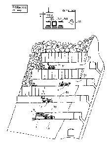
Figure 12 shows a mine comprising several tunnels 8a ¨ 8d and dif-
ferent mine vehicles la ¨ id operating in the tunnels. At the lowermost tunnel
8a there is face drilling rig la drilling blast holes to an end face of the
tunnel. A
fan drilling rig lb is drilling a fan-like drilling pattern in a second tunnel
8b. In a
third tunnel 8c a loading vehicle 1 c is carrying detached rock material, and
fur-
ther, a charging vehicle id is operating in a fourth tunnel 8d. All these mine
vehicles operating in the mine may be provided with monitoring or scanning
modules and/or other monitoring means whereby they may produce monitoring
data and send it to the mine control unit MCU. The mine control unit MCU may
be located in a control room and may be connected to one or more terminal
devices or display units DU for providing the operator 33 information about
the
current status and for displaying situation reports.
CA 02936686 2016-07-13
WO 2015/107070 24 PCT/EP2015/050567
When the fan drilling rig lb is utilized in tunneling, it may operate in
a pilot tunnel and may drill blast holes to walls and ceiling of the pilot
tunnel.
After blasting the drill holes the pilot tunnel is enlarged. Two successive
drill
hole fans define length of a round R. In the face drilling, the face drilling
rig la
drills drill holes to an end surface i.e face of the tunnel 8a. After
development
excavation, the formed mine spaces may be surveyed by means of the moni-
toring modules of the mine vehicles. The monitoring module may comprise
scanning device for scanning the surfaces of the tunnels 8a ¨ 8d.
Figure 13 shows principles of a fan drilling 34 and face drilling 35. In
the fan drilling a fan drilling pattern 36 defining positions and directions
of drill
holes is used. In the face drilling a face drilling pattern 37 is used. The
drilling
patterns 36 and 37 define length of a round R. Figure 13 also discloses a tun-
nel line TL, which may be predesigned and input to the mine control unit. Fur-
ther, inner profile 38, 39 of the tunnel along the tunnel line may also be
prede-
termined. The mine plan may also define a minimum profile and a maximum
profile for the desired tunnel portions.
Figure 14 shows some quality problems in tunnel profile caused by
inaccurate drilling of blast holes. In an upper part of the Figure 14 over
excava-
tion 40 causes deviations from the planned inner profile and also causes un-
necessary excavation work.
The drawings and the related description are only intended to illus-
trate the idea of the invention. In its details, the invention may vary within
the
scope of the claims.