Note: Descriptions are shown in the official language in which they were submitted.
CA 02938864 2016-08-04
WO 2015/126606 PCT/US2015/014101
LOCALIZATION OF A WIRELESS USER EQUIPMENTDEVICE IN A TARGET ZONE
BACKGROUND
[0001] Localization information is increasingly being leveraged for various
location-
based services (e.g., navigation, mobile commerce, etc.). These location-based
services
utilize information pertaining to the location of a mobile device to enable a
multitude of
computing applications. Often, the location of a mobile device may be obtained
through the
use of the existing global positioning system (GPS) (i.e., GPS satellites) due
to the fact that
most mobile devices are equipped with GPS receivers.
[0002] However, in certain environments (e.g., indoor environments), GPS
signals are
unavailable. Buildings and similar objects that obstruct GPS signals often
lead to the
unavailability of GPS signals used for localization. This has led to research
efforts on
localization for mobile devices using other, non-GPS approaches. At least one
approach is
to leverage the existing infrastructure of WiFi access points to enable
localization based on
available radio-frequency (RF) signals in lieu of the unavailable GPS signals.
The WiFi
infrastructure is widely deployed infrastructure and therefore suitable for
localization due
to the locality preserving properties of WiFi signals.
[0003] There are generally two techniques used for WiFi-based localization:
(1)
fingerprint-based localization, and (2) model-based localization. Fingerprint-
based
localization infers location of a device by comparing an observed WiFi sample
against a
location database, which contains a number of collected WiFi samples and their
associated
positions. The WiFi sample(s) that best matches the signal query is used for
localization.
However, fingerprint-based localization requires an extensive and costly pre-
deployment
effort to build the location database with enough training samples for
accurate localization.
[0004] Model-based localization, on the other hand, does not rely too heavily
on the
density of training samples. Accordingly, the number of training samples used
for model-
based localization may be reduced significantly compared to fingerprint-based
localization
methods, which results in a much cheaper system. Model-based localization
works by using
a signal propagation model (e.g., a log-distance path loss (LDPL) model) of a
WiFi signal
to obtain model parameters of WiFi access points (APs) for predicting received
signal
strength (RSS) at various locations within an area. Thereafter, a location
query with certain
WiFi observations may be resolved to a location that best fits the WiFi
observations to the
signal propagation model.
1
CA 02938864 2016-08-04
WO 2015/126606 PCT/US2015/014101
[0005] While the model-based localization approach significantly reduces the
pre-
deployment effort and the associated cost of the system as compared to
fingerprint-based
localization, existing model-based approaches utilize a single ("global")
model for
localization within an entire area (e.g., an indoor environment) for each AP.
A global path
loss model uses a single path loss constant to reflect the assumption that RSS
should
decrease uniformly with increasing distance from a given WiFi AP. However, due
to the
complexity of many environments (e.g., walls, cubicles, pedestrians, etc.)
that may all affect
WiFi signal propagation, this assumption is not true of many environments,
leading to
uneven model fitness across different sub-areas of an environment having
complex
properties. In other words, model-based localization using a global signal
propagation
model for an entire area is oversimplified, leading to suboptimal performance
of model-
based localization systems.
SUMMARY
[0006] Described herein are techniques and systems for performing wireless-
based
localization based at least in part on a zonal framework. An area (i.e.,
surface or space) may
be partitioned into multiple zones, and one or more signal propagation models
may be
generated for one or more wireless access points (APs) within each zone. The
result is a set
of zonal signal propagation models that allow for improved model fitness on a
per-zone
basis, leading to improved accuracy in performing localization of wireless
communication
devices within the area. The embodiments disclosed herein may be utilized in
any
environment containing an existing wireless communication infrastructure.
Although the
techniques and systems described herein are often presented in the context of
indoor
environments where GPS signals are typically unavailable, the embodiments
disclosed
herein are equally applicable to outdoor environments where a wireless
communication
infrastructure is available, notwithstanding the presence of available GPS
signals. Thus, the
techniques and systems described herein are not limited to indoor
localization.
[0007] In some embodiments, a computer-implemented process of performing
localization for a wireless communication device at an unknown location
includes receiving
a location query associated with the wireless communication device, selecting
a target zone
among multiple available zones of an area, and estimating a location of the
wireless
communication device based at least in part on one of a signal propagation
model associated
with the target zone (i.e., zonal model) or a fingerprint-based localization.
[0008] In some embodiments, a system configured to perform localization based
on a
zonal framework includes one or more processors, and one or more memories
having the
2
81798598
following components: a zonal localization component to receive a location
query associated
with a wireless communication device, and a zone selection component to select
a target zone
from multiple available zones of an area. The zonal localization component may
be
configured to estimate a location of the wireless communication device based
at least in part
on one of a signal propagation model associated with the target zone or a
fingerprint-based
localization.
[0009] By utilizing a zonal framework that partitions an area into
multiple zones for
facilitating zonal localization, performance (i.e., localization accuracy) may
be improved by
virtue of achieving better model fitness for any given location query from a
wireless
communication device. As long as sufficient training data is available to
enable generation of
valid zonal signal propagation models for wireless APs, the zonal framework
will improve
model-based localization using any given wireless communication
infrastructure. In addition,
denser training data will further improve the performance of the disclosed
zonal framework,
but the embodiments disclosed herein are suitable for high accuracy
localization even with
minimal training data available.
[0009a] According to one aspect of the present invention, there is provided a
computer-
implemented method comprising: receiving a location query associated with a
wireless
communication device; dividing, by one or more processors, an area into
multiple zones,
individual zones of the multiple zones being located at least partially within
the area, and
individual zones of the multiple zones being associated with respective zonal
signal
propagation models; determining, by the one or more processors, an estimated
location of the
wireless communication device within the area, the estimated located being
based at least in
part on a global signal propagation model associated with the area; selecting,
by the one or
more processors, a target zone among the multiple zones that is closest to the
estimated
location of the wireless communication device; and determining, by the one or
more
processors, a final estimated location of the wireless communication device
based at least in
part on a zonal signal propagation model associated with the target zone, the
zonal signal
propagation model being one of the respective zonal signal propagation models.
3
CA 2938864 2020-01-28
81798598
[0009b] According to another aspect of the present invention, there is
provided a system
comprising: one or more processors; and one or more memories storing computer-
executable
instructions that, upon execution by the one or more processors, cause
performance of
operations comprising: receiving a location query associated with a wireless
communication
device; determining a first location estimate of the wireless communication
device within an
area based at least in part on a global signal propagation model associated
with the area as a
whole; selecting a target zone among multiple available zones of the area, the
target zone
being associated with a zonal signal propagation model, each of the multiple
available zones
located at least partially within the area; determining a second location
estimate of the
wireless communication device within the area based at least in part on the
zonal signal
propagation model; determining that a first model fitness error of the global
signal
propagation model is less than a second model fitness error of the zonal
signal propagation
model; and determining a final location estimate of the wireless communication
device based
at least in part on the global signal propagation model.
[0009c] According to still another aspect of the present invention, there is
provided a
computer-implemented method comprising: partitioning, by one or more
processors, an area
into multiple zones, individual zones of the multiple zones being associated
with respective
zonal signal propagation models; receiving a location query associated with a
wireless
communication device; determining, by the one or more processors, an estimated
location of
the wireless communication device within the area, the estimated location
being based at least
in part on a global signal propagation model associated with the area;
selecting, by the one or
more processors, a target zone among the multiple zones that is closest to the
estimated
location of the wireless communication device; and determining, by the one or
more
processors, a final estimated location of the wireless communication device
based at least in
part on a zonal signal propagation model associated with the target zone, the
zonal signal
propagation model being one of the respective zonal signal propagation models,
wherein the
zonal signal propagation model associated with the target zone and the global
signal
propagation model associated with the area are path loss signal propagation
models.
[0009d] According to yet another aspect of the present invention, there is
provided a
computer-implemented method for utilizing zonal signal propagation models to
estimate a
3a
CA 2938864 2020-01-28
81798598
location of a wireless communication device, the method comprising: receiving
a location
query associated with the wireless communication device; determining, by one
or more
processors, an estimated location of the wireless communication device within
an area, the
estimated location being based at least in part on a global signal propagation
model associated
with the area; selecting, by the one or more processors, a target zone among
multiple available
zones of the area that is closest to the estimated location of the wireless
communication
device, wherein individual zones of the area are located at least partially
within the area and
are associated with respective zonal propagation models; and determining, by
the one or more
processors, a final estimated location of the wireless communication device
based at least in
part on a zonal signal propagation model associated with the target zone, the
zonal signal
model being one of the respective zonal signal propagation models.
[0009e1 According to yet a further aspect of the present invention, there is
provided a
system comprising computer means arranged in use to implement a method as
described
above or detailed below.
[0009f] According to still another aspect of the present invention, there
is provided one or
more computer-readable storage medium having stored thereon computer
executable
instructions that when executed by a processor cause the processor to perform
a method as
described above or detailed below.
[0010] This Summary is provided to introduce a selection of concepts in
a simplified form
that is further described below in the Detailed Description. This Summary is
not intended to
identify key features or essential features of the claimed subject matter, nor
is it intended to be
used to limit the scope of the claimed subject matter.
BRIEF DESCRIPTION OF THE DRAWINGS
[0011] The detailed description is described with reference to the
accompanying figures.
In the figures, the left-most digit(s) of a reference number identifies the
figure in which the
reference number first appears. The same reference numbers in different
figures indicates
similar or identical items.
3b
CA 2938864 2020-01-28
= 81798598
[0012] Fig. 1 illustrates an example area that may be partitioned into
multiple zones for
use with wireless-based localization techniques using zonal signal propagation
models.
[0013] Fig. 2 illustrates an example architecture for performing wireless-
based
localization using a zonal framework, including a block diagram representing
example
localization server(s).
[0014] Fig. 3 is a flow diagram of an illustrative process for zonal
model training.
[0015] Fig. 4 is a flow diagram of an illustrative process for zonal
localization.
[0016] Fig. 5 is a flow diagram of an illustrative process for selecting
a target zone during
zonal localization.
3c
CA 2938864 2020-01-28
CA 02938864 2016-08-04
WO 2015/126606 PCT/US2015/014101
[0017] Fig. 6 illustrates an example diagram of an area comprised of multiple
floors, as
well as a flow diagram of an illustrative process for determining a target
floor for zonal
localization.
[0018] Fig. 7 is a flow diagram of an illustrative process for device gain
diversity
compensation.
DETAILED DESCRIPTION
[0019] Embodiments of the present disclosure are directed to, among other
things,
techniques and systems for performing wireless-based localization using a
zonal framework.
The techniques and systems described herein may be implemented in a number of
ways.
Example implementations are provided below with reference to the following
figures.
Example Area and Zone Partitioning
[0020] Fig. 1 illustrates an example area 100 that may be partitioned into
multiple zones
102(1), 102(2),..., 102(N) for use with wireless-based localization techniques
using zonal
signal propagation models. Fig. 1 shows the area 100 as a two dimensional (2D)
area that is
representative of an indoor environment (e.g., an office building). It is to
be appreciated,
however, that areas, as used herein, are not limited to indoor areas, as
outdoor areas with
wireless communication infrastructures in place may also benefit from the
disclosed
techniques and systems. While the area 100 is represented as a 2D area, the
area 100
comprises a three dimensional (3D) space, perhaps containing multiple levels
(e.g., floors)
that may be treated as sub-portions of the area 100 to be partitioned into
zones. Any 2D
surface included within the area 100 may be flat or curved, continuous or
discontinuous,
and any size and/or shape. Fig. 1 shows the area 100 as being rectangular in
shape; typical
of many indoor environments.
[0021] The area 100 of Fig. 1 is shown to include "complex" properties in
terms of walls,
doors, cubicles, partitions, glass windows, and even people (generally
referred to as
"objects" herein) that exist in the environment. By contrast, a completely
empty indoor
space without any objects disposed therein may be considered an area 100 that
is simple and
unifomi, or otherwise not "complex".
[0022] The area 100 may further include a plurality of wireless access points
(APs) 104(1),
104(2),..., 104(P) (e.g., WiFi APs) disposed at various locations throughout
the area 100.
The wireless APs 104(1)-(P) (sometimes called "WiFi APs 104(1)-(P)" herein)
serve as
radio-frequency (RF) transmitters configured to connect a group of wireless
communication
devices (e.g., mobile phones, tablets, etc.) to a wired local area network
(LAN). The WiFi
APs 104(1)-104(P) may act as network hubs configured to relay data between
connected
4
CA 02938864 2016-08-04
WO 2015/126606 PCT/US2015/014101
wireless communication devices and a connected wired device (e.g., an Ethernet
hub or
switch). This setup allows a plurality of wireless communication devices to
utilize a wired
connection for communication with other wired and wireless communication
devices.
[0023] In some embodiments, the WiFi APs 104(1)-(P) may incorporate other
functionalities as well, such as router functionality, or hub/switching
functionality by acting
as an Ethernet switch itself. In other embodiments, the WiFi APs 104(1)-(P)
may be "thin"
APs that merely send and receive wireless data. In general, the WiFi APs
104(1)-(P) support
communications via frequencies defined by the IEEE 802.11 standards, but any
suitable
wireless communication protocol with available infrastructure may be used with
the
techniques and systems disclosed herein. WiFi APs that are based on IEEE
802.11 standards
are widely deployed and are therefore contemplated for use as the WiFi APs
104(1)-(P)
shown in Fig. 1. Thus, a WiFi AP is a wireless communication transceiver
device (i.e., access
point) that provides access to a network. Further, WiFi-enabled devices refer
to wireless
communication devices that use wireless local area network (WLAN)
communication to
exchange data with other similar devices and the WiFi APs 104(1)-(P). The WLAN
communication may be performed via frequencies defined by the IEEE 802.11
standards.
[0024] Fig. 1 further illustrates a plurality of wireless communication
samples 106(1),
106(2),..., 106(Q) (sometimes called "WiFi samples 106(1)-(Q)" herein) that
have been
observed throughout at least a portion of the area 100. Particularly, users
carrying WiFi-
enabled devices (e.g., mobile phones, tablets, etc.) and located throughout
the area 100
record received signal strength (RSS) measurements corresponding to ones of
the WiFi APs
104(1)-(P) in their view at those various locations. In some embodiments, the
WiFi samples
106(1)-(Q) represent <location, RSS> tuples for each WiFi AP 104 seen by the
WiFi-enabled
device taking the WiFi sample 106. The size of each of the WiFi samples 106(1)-
(Q) (shown
as bubbles of varying size in Fig. 1) is indicative of the RSS measurements in
terms of WiFi
signal strength at that location. That is, the bigger the bubble for each WiFi
sample 106(1)-
(Q) shown in Fig. 1, the greater the RSS measurement. Accordingly, each of the
WiFi
samples 106(1), 106(2),..., 106(Q) is a wireless communication sample that
indicates the
strength of a wireless communication signal at a particular location.
[0025] The WiFi samples 106(1)-(Q) shown in Fig. 1 may make up training data
for
model-based localization because the model parameters for each WiFi AP 104(1)-
(P) may
be calculated for a path loss signal propagation model (e.g., a LDPL model)
from the
information that is reported by the WiFi samples 106(1)-(Q). Although the
embodiments
herein are predominantly described with reference to using an LDPL model,
other models,
5
CA 02938864 2016-08-04
WO 2015/126606 PCT/US2015/014101
such as linear models, may be utilized herein without changing the basic
characteristics of
the system. In general, the WiFi samples 106(1)-(Q) may be reported to a
localization server
and used to train zonal signal propagation models, and to perform localization
for WiFi-
enabled devices using the zonal models.
[0026] The techniques and systems described herein use a zonal framework that
is based
on the multiple zones 102(1)-(N) into which the area 100 is partitioned or
divided. Fig. 1
shows that a first zone 102(1) encompasses a sub-area of the area 100 that
contains multiple
cubicles, while a second zone 102(2) encompasses another sub-area that is a
corridor or
walking pathway/hallway for people to traverse the area 100, and an Nth zone
102(N)
encompasses a conference room. The zone partitioning shown in Fig. 1 is but
one illustrative
example manner in which the area 100 may be partitioned into multiple zones
102(1)-(N),
and it is to be appreciated that various suitable techniques for partitioning
the area 100 into
multiple zones 102(1)-(N) are contemplated without changing the basic
characteristics of
the system disclosed herein. Examples of various zone partitioning techniques
will be
discussed in more detail below.
[0027] According to embodiments herein, zonal signal propagation models may be
generated or built for the WiFi APs 104(1)-(P) based on observations from the
respective
zones 102(1)-(N). In general, a valid zonal signal propagation model may be
generated from
a threshold number of training samples observed within a specific zone 102. In
some
embodiments, the threshold number of training samples to be observed is five
training
samples. This threshold number of five training samples is primarily based on
the fact that
there are generally four parameters of a LDPL model that are to be solved for
in building
the respective zonal signal propagation model. Equation (1), below, shows a
LDPL equation
that may be used for any given zonal signal propagation model:
pii = ¨ 1.0yi dii R (1)
[0028] In Equation (1), pij represents the RSS measurement (e.g., measured in
decibel-
milliwatts (dBm)) seen by a WiFi-enabled device at a certain unknown location,
j, that is a
distance from the ith WiFi AP 104. 131 is the RSS measured at the reference
point (typically
1 meter away from the AP) of the ith WiFi AP 104, yi is the path loss constant
(i.e., rate of
decrease in RSS in the vicinity of the th WiFi AP 104). Du is a distance from
the WiFi-
enabled device at location, j, to the ith WiFi AP 104, and R is a random
constant used to
model the variations in the RSS due to multi-path effects. After collecting a
threshold
number (in the case of Equation (1), five) of WiFi samples 106(1)-(Q) for each
zone 102(1)-
6
CA 02938864 2016-08-04
WO 2015/126606 PCT/US2015/014101
(N), the set of parameters for each WiFi AP 104(1)-(P) may be calculated by
minimizing the
average model fitness error according to Equation (2), below:
k
model fitness error = =1
¨E = 'model RSS ¨ measured RSSI (2)
k 1
[0029] In Equation (2), k is the number of WiFi samples 106(1)-(Q) observed in
the
respective zone 102 for which the model is being generated. Accordingly, one
or more zonal
models may be trained for each WiFi AP 104(1)-(P) within the area 100.
Accordingly, any
given WiFi AP 104 may have multiple zonal models because Wi-Fi enabled devices
may
see the given WiFi AP 104 from different zones of the multiple zones 102(1)-
(N).
Conversely, a given WiFi AP 104 may not be associated with any zonal models if
there is
not enough training data available to build a valid zonal model.
[0030] In some embodiments, a fallback measure may be taken by training a
global model
for particular ones of the WiFi APs 104(1)-(P) in the area 100. Such a global
model may be
used for WiFi APs 104 that are not associated with a zonal signal propagation
model for at
least one zone 102. For example, for a given WiFi AP 104 within a particular
zone 102, if
the number of WiFi samples 106 within the particular zone 102 is insufficient
(e.g., below
a threshold number of samples needed for a valid zonal model), while the
number of all
WiFi samples 106 in view of the given WiFi AP 104 is sufficient (e.g., at or
above a
threshold) for a valid global model, a global model may be trained for the
given WiFi AP
104 and associated with the particular zone 102. Accordingly, the number of
WiFi samples
106 may be sufficient for some of the zones 102(1)-(N), yet insufficient for
others of the
zones 102(1)-(N). For example, if the area 100 were to contain ten WiFi
samples 106(1)-
(Q), with six of the WiFi samples 106(1)-(Q) within a first zone 102(1), and
four of the WiFi
samples 106(1)-(Q) in a second zone 102(2), the first zone may have a zonal
model
generated for it if six WiFi samples 106 are sufficient for zonal model
generation, while the
second zone 102(2) may fall back to using a trained global model based on all
ten WiFi
samples 106(1)-(Q).
Example Architecture
[0031] Fig. 2 illustrates an example architecture 200 for performing wireless-
based
localization using a zonal framework. In the architecture 200, one or more
users 202 are
associated with mobile, wireless communication computing devices ("wireless
communication devices" or "WiFi-enabled devices") 204(1), 204(2) ..., 204(N)
that are
configured to assist in the zonal (and global) model training, and to
facilitate localization of
the WiFi-enabled devices 204(1)-(N). For enabling model training, the WiFi-
enabled
7
CA 02938864 2016-08-04
WO 2015/126606 PCT/US2015/014101
devices 204(1)-(N) may be configured to scan for WiFi APs, such as the WiFi
APs 104(1)-
(P) shown in Fig. 1, in their range, and to receive and record RSS
measurements
corresponding to the WiFi APs 104(1)-(P) in their view (i.e., in range) at
various locations
throughout an area, such as the area 100 of Fig. 1. The WiFi-enabled devices
204(1)-(N)
may transmit WiFi samples 206 based on such RSS measurements to one or more
localization servers 208(1), 208(2),..., 208(P) via a network(s) 210. These
WiFi samples
206 may comprise observations of RSS measurements used as training data for
training
zonal and global signal propagation models.
[0032] To facilitate a localization process, however, the WiFi-enabled devices
204(1)-(N)
may be similarly configured to transmit location queries in the form of the
WiFi samples
206 to the localization server(s) 208(1)-(P) in order to resolve a current
position or location.
In either of the training process or the localization process, the detection
and transmission
of WiFi samples 206 via the network(s) 210 may be implemented as a push model
where
the WiFi-enabled devices 204(1)-(N) periodically scan and push information to
the
localization server(s) 208(1)-(P), or as a pull model where the localization
server(s) 208(1)-
(P) request a scan.
[0033] The WiFi-enabled devices 204(1)-(N) may be implemented as any number of
computing devices, including a laptop computer, a portable digital assistant
(PDA), a mobile
phone, a tablet computer, a portable media player, portable game player, smart
watch, and
so forth. Each client computing device 204(1)-(N) is equipped with one or more
processors
and memory to store applications and data. According to some embodiments, a
localization
application is stored in the memory and executes on the one or more processors
to provide
the WiFi samples 206 to the localization server(s) 208(1)-(P) and/or perform a
localization
process on the WiFi-enabled devices 204(1)-(N), such as when trained zonal
(and global)
signal propagation models may be downloaded over the network(s) 210 from the
localization server(s) 208(1)-(P). In this manner, model training may be
performed on the
localization server(s) 208(1)-(P), while localization may be performed on the
WiFi-enabled
devices 204(1)-(N). Alternatively, both training and localization may be
perfamied on the
localization server(s) 208(1)-(P).
[0034] Although the network(s) 210 is described in the context of a web-based
system,
other types of client/server-based communications and associated application
logic may be
used. The network(s) 210 is representative of many different types of
networks, such as
cable networks, the Internet, local area networks, mobile telephone networks,
wide area
networks and wireless networks, or a combination of such networks.
8
CA 02938864 2016-08-04
WO 2015/126606 PCT/US2015/014101
[0035] The localization server(s) 208(1)-(P) may comprise one or more servers,
perhaps
arranged as a server farm or a server cluster. Other server architectures may
also be used to
implement the localization server(s) 208(1)-(P). In some embodiments, the
localization
server(s) 208(1)-(P) are capable of handling requests, such as location
queries, from many
users 202 and serving, in response, various information and data regarding
position
determinations to the WiFi-enabled devices 204(1)-(N), allowing the user 202
to interact
with the data provided by the localization server(s) 208(1)-(P). In this
manner, the
localization server(s) 208(1)-(P) may be implemented as part of any site or
service
supporting localization for users 202 associated with the WiFi-enabled devices
204(1)-(N),
including location-based services, navigation services, mobile commerce
services, and so
forth.
[0036] In some embodiments, the WiFi samples 206 are received by the
localization
server(s) 208(1)-(P) and stored in a data store as survey data 212, such as
during a training
phase for training or building zonal (and global) signal propagation models.
This survey
data 212 may be collected in any suitable type of data store for storing data,
including, but
not limited to, a database, file system, distribution file system, or a
combination thereof. The
survey data 212 may be configured to collect any suitable information that is
included in the
WiFi samples 206 received via the network(s) 210, such as RSS measurements,
identification and location information pertaining to in-range WiFi APs 104(1)-
(P), and the
like.
[0037] In general, the localization servers 208(1)-(P) are equipped with one
or more
processors 214 and one or more forms of computer-readable media 216. The
localization
servers 208(1)-(P) may also include additional data storage devices (removable
and/or non-
removable) such as, for example, magnetic disks, optical disks, or tape. Such
additional
storage may include removable storage and/or non-removable storage. Computer-
readable
media 216 may include, at least, two types of computer-readable media 216,
namely
computer storage media and communication media. Computer storage media may
include
volatile and non-volatile, removable, and non-removable media implemented in
any method
or technology for storage of information, such as computer readable
instructions, data
structures, program modules, or other data. The system memory, the removable
storage and
the non-removable storage are all examples of computer storage media. Computer
storage
media includes, but is not limited to, random access memory (RAM), read-only
memory
(ROM), erasable programmable read-only memory (EEPROM), flash memory or other
memory technology, compact disc read-only memory (CD-ROM), digital versatile
disks
9
CA 02938864 2016-08-04
WO 2015/126606 PCT/US2015/014101
(DVD), or other optical storage, magnetic cassettes, magnetic tape, magnetic
disk storage
or other magnetic storage devices, or any other non-transmission medium that
may be used
to store the desired information and which may be accessed by the localization
servers
208(1)-(P). Any such computer storage media may be part of the localization
servers 208(1)-
(P). Moreover, the computer-readable media 216 may include computer-executable
instructions that, when executed by the processor(s) 214, perform various
functions and/or
operations described herein.
[0038] In contrast, communication media may embody computer-readable
instructions,
data structures, program modules, or other data in a modulated data signal,
such as a carrier
wave, or other transmission mechanism. As defined herein, computer storage
media does
not include communication media.
[0039] The computer-readable media 216 may be used to store any number of
functional,
or executable, components, such as programs and program modules that are
executable on
the processor(s) 214 to be run as software. The components included in the
computer-
readable media 216 may serve primarily one of two purposes, which are either
to develop
and train signal propagation models (labeled "Training" in the block diagram
of Fig. 2), or
to perform localization for the WiFi-enabled devices 204(1)-(N) (labeled
"Localization" in
the block diagram of Fig. 2).
Training
[0040] The main component used for development and training of the zonal
signal
propagation models, according to embodiments disclosed herein, is a zonal
model training
component 218 that is configured to generate one or more zonal signal
propagation models
for individual ones of the WiFi APs 104(1)-(P). The zonal model training
component 218
may generate the one or more zonal propagation models by solving for model
parameters
of a path loss model based on observations within particular ones of the zones
102(1)-(N)
obtained from the survey data 212.
[0041] As part of this zonal model training process, the zonal model training
component
218 may include a zone partitioning component 220 that is configured to divide
or partition
an area 100 of interest into multiple zones 102(1)-(N). Zone partitioning may
be performed
in a variety of suitable ways using various techniques and algorithms.
[0042] In some embodiments, the area 100 may be partitioned into multiple
zones by
leveraging a map tile system that uses, for example, a quad-tree structure
across multiple
levels of detail (i.e., zoom levels) to partition a planar map into tiles.
Each tile of a certain
area may be treated as a zone of the area 100. In this scenario, the zones are
uniform in size
CA 02938864 2016-08-04
WO 2015/126606 PCT/US2015/014101
and shape at a given level of the map tile system, since map resolution is a
function of the
zoom level. One illustrative example of a map tile system is the Bing Maps
Tile System
provided by Microsoft Corporation of Redmond, Washington. In such a map tile
system,
a map of an area may be rendered at different levels having square sub-areas
of a certain
side length that may be measured in real distance measurements (i.e., feet,
meters, etc.)
based on the zoom level and the latitude that is rendered. Each tile of a
known side length
may then be designated as a zone. The identifiers of each tile may be used to
identify each
zone of the area 100. In the example area 100 shown in Fig. 1, the entire area
100 may be
representative of a rendered map of a map tile system at a zoom level that is
relatively close
to the surface of the earth.
[0043] In some embodiments, the zone partitioning component 220 may partition
the area
100 into multiple zones by using basic rules that specify a maximum or minimum
size of a
geometric shape suitable for the area 100. For example any suitable polygonal
shape of a
maximum or minimum size may be utilized to partition the area 100 into
multiple zones. In
other embodiments, zones may be partitioned at least partly using a manual, or
human,
process.
[0044] In yet other embodiments, the zone partitioning component 220 may
partition the
area 100 based on the availability of training data within the area 100. For
example, the zone
partitioning component 220 may be configured to determine sub-areas within the
area 100
that contain at least a threshold number (e.g., five) of observed training
samples, such as the
WiFi samples 206, and may designate each sub-area that meets the threshold
criterion as a
separate zone within the area 100. As another example, a sub-area found to
contain more
than a threshold number of observed training samples may be bisected into
smaller sub-
areas as long as those resulting sub-areas contain a threshold number of
training samples.
As yet another example, the zone partitioning component 220 may designate
"seeding
locations" (selected randomly or using rules such as "inner most" portion of
the area 100 or
at the corners of the area 100) and may grow sub-areas around the seeding
locations until a
threshold number of training samples are contained within the sub-area, and
these may be
designated as zones of the area 100. Other suitable means of partitioning the
area 100 into
multiple zones may be utilized without departing from the basic
characteristics of the system
disclosed herein.
[0045] In some embodiments, the zone partitioning component 220 may partition
the area
into multiple zones, at least some of which are overlapping each other. Use of
overlapping
zones may mitigate any large model fitness errors observed at zone boundaries.
11
CA 02938864 2016-08-04
WO 2015/126606 PCT/US2015/014101
[0046] In some embodiments, sub-areas that do not contain any, or enough,
training data
may be regarded or designated as "empty zones." The empty zones may not be
associated
with a zonal signal propagation model because a valid zonal signal propagation
model may
require a threshold amount of training samples. Accordingly, zone partitioning
may be
performed without regard to the availability of training data, in which case,
some zones may
turn out to be empty zones. In other embodiments, zone partitioning may depend
on, or be
driven by, the availability of training data so that only certain sub-areas of
the area 100 are
designated as zones, while the remaining portion(s) of the area 100 make up a
portion of the
area that may be treated as a "global" zone.
[0047] In certain scenarios, portions of the area 100 may be more heavily
traversed with
WiFi-enabled devices 204(1)-(N) than others, and those sub-areas lend
themselves to
smaller zone sizes based on the high density of training data in those sub-
areas. For example,
walking pathways, or similar "common areas" within an environment, may have
more
training data available, while private offices or other restricted locations
may not have any,
or enough, training data in order to build valid zonal signal propagation
models.
Accordingly, the zone partitioning component 220 may be configured to identify
sub-areas
of an area 100 as "high traffic" sub-areas for finer zone partitioning, which
may lead to
greater localization accuracy.
[0048] The computer-readable media 216 may further include a global model
training
component 222 as part of the model training capability of the localization
server(s) 208(1)-
(P). The global model training component 222 is configured to train a global
model for a
given area 100 based on all observations (i.e., WiFi samples 206) from all
WiFi APs 104(1)-
(P) within the area 100. Thus, a global model may be obtained and utilized for
various
fallback measures or augmentation of the localization process to resolve a
location of a
WiFi-enabled device 204 with greater accuracy.
[0049] Both of the zonal and global model training components 218 and 222 may
dispatch
WiFi-enabled devices 204(1)-(N) to the area 100, including within the multiple
zones
102(1)-(N), to collect the survey data 212 (i.e., training data) used for
training the zonal and
global models. Additionally, or alternatively, users 202 with associated WiFi-
enabled
devices 204(1)-(N) that are already within the area 100 may be leveraged for
receiving WiFi
samples 206 for the survey data 212. In either case, the area 100 may be
partitioned into
multiple zones without regard to the training samples, or the
dispatched/existing training
samples may actually drive the partitioning of the area 100 into zones. For
any given WiFi
AP 104 within a zone 102, as long as enough training data is available, a
zonal model for
12
81798598
the given WiFi AP 104 may be established. Accordingly, not all WiFi APs 104(1)-
(P) will
have a zonal signal propagation model for each zone. Any WiFi AP 104 without a
zonal
signal propagation model in a certain zone may use the fallback global model
for that zone
without a zonal signal propagation model for localization purposes. The global
model may
be developed by the global model training component 222.
[0050] After training, the zonal model training component 218 may maintain a
model
parameter set (e.g., transmission power, P, path loss coefficient, y, etc.)
for each WiFi AP
104(1)-(P). These model parameter sets may be generated based on minimizing
the model
fitness error, as described above. Thus, each zone of the multiple zones
102(1)-(N) may be
associated with a plurality of parameter sets, one parameter set for each WiFi
AP 104(1)-
(P). Likewise, a single WiFi AP 104 may have different model parameter sets
for different
ones of the multiple zones 102(1)-(N).
[0051] In some embodiments, the zonal signal propagation models may be
optimized by
the zonal model training component 218 by including a certain portion of
training data from
neighboring zones. That is, in developing a zonal model for a given zone, the
zonal model
training component 218 may look to available training data in zones
neighboring (e.g.,
adjacent) the given zone in order to develop a valid zonal signal propagation
model for the
given zone. This technique of including training data from neighboring zones
may enable
empty zones to obtain valid zonal models so long as there is enough training
data available
from neighboring zones.
Localization
[0052] The main component used for zonal localization, according to
embodiments
disclosed herein, is a zonal localization component 224 that is configured to
estimate a
location of a given WiFi-enabled device 204 based at least in part on one of a
zonal signal
propagation model developed during the training phase, or a fingerprint-based
localization
scheme.
[0053] As part of this zonal localization process, the zonal localization
component 224
may include a zone selection component 226 that is configured to select a
target zone among
multiple available zones of an area, such as the area 100 of Fig. 1. The goal
of the zone
selection component 226 is to find the zone with the best locality for a given
location query
received from a WiFi-enabled device 204. That is, the selected target zone
should be the
zone that the querying WiFi-enabled device 204 is currently disposed within.
However,
since the location of the querying WiFi-enabled device 204 is unknown, various
13
CA 2938864 2020-01-28
CA 02938864 2016-08-04
WO 2015/126606 PCT/US2015/014101
methodologies and techniques may be utilized to carry out zone selection for
purposes of
localization.
[0054] In general, the zone selection component 226 is configured to select a
target zone
by pruning away, or otherwise ignoring, unlikely zones and pick a best
candidate(s) zone as
the target zone. By pruning away, or ignoring, unlikely zones, the zone
selection component
226 may reduce system complexity for the zone selection process without
compromising
localization accuracy. In some embodiments, this pruning or filtering may be
implemented
using a bloom filter, which rapidly, and memory-efficiently, determines
whether a zone is
excluded from the set of candidate zones. More specifically, a bloom filter
may be created
for each zone with access to information on all of the WiFi APs 104(1)-(P) in
each zone.
The bloom filter may then hash all of the WiFi APs 104(1)-(P) observed in a
WiFi sample
206 from a WiFi-enabled device 204 in each zone, and compare the WiFi APs
104(1)-(P)
in the WiFi sample 206 to each zone's listing of WiFi APs 104(1)-(P). If a
common identifier
for a WiFi AP 104 is found for a particular zone based on the comparison, the
corresponding
bits of the zone's bloom filter may be set to 1, and the zones that are not
set to 1 are excluded
from the set of candidate zones. The zone selection component 226 may then
determine if
the number of common WiFi APs 104(1)-(P) in a zone meets or exceeds a
threshold number
(e.g., four common WiFi APs), and if not, that zone may be filtered out of the
candidate set.
Zones within the candidate set may be ranked based on the number of common
WiFi APs
104(1)-(P) to those reported in the WiFi sample 206.
[0055] In some embodiments, the zone selection component 226 selects a target
zone from
the multiple available zones 102(1)-(N) using a Naïve Bayesian zone selection
technique
that involves receiving a WiFi sample 206 from a WiFi-enabled device 204, in
which the
WiFi sample 206 reporting a RSS measurement from one or more of the WiFi APs
104(1)-
(P). Based on the selection, the zone selection component 226 uses histograms
of the one or
more WiFi APs 104(1)-(P) to calculate a likelihood of observing the received
WiFi sample
206 in individual ones of the multiple available zones 102(1)-(N). The zone
that maximizes
the likelihood of observing the WiFi sample 206 is then selected as the target
zone for
localization purposes. This zone selection process may include pruning away or
filtering out
zones based on a comparison of WiFi APs 104(1)-(P) in the area 100 to the WiFi
APs
104(1)-(P) reported in the WiFi sample 206 to obtain a set of candidate zones
with at least
one common WiFi AP 104 to the WiFi APs 104(1)-(P) reported in the WiFi sample
206. In
this manner, only histograms of the WiFi APs 104(1)-(P) within the candidate
zones are to
be considered in the zone selection process.
14
CA 02938864 2016-08-04
WO 2015/126606 PCT/US2015/014101
[0056] It should be appreciated that in order to carry out the embodiments
disclosed herein,
all of the WiFi APs 104(1)-(P) in a zone may be associated with a histogram.
Each histogram
is a probability distribution of the observed RSS measurements at various
locations within
a zone of the area 100. Accordingly, each zone is associated with a
probability distribution
for a single WiFi AP 104. As noted above, the histograms of the WiFi APs
104(1)-(P) may
be utilized for zone selection purposes. On the other hand, empty zones should
not require
a histogram. As noted above, a global signal propagation model may be utilized
for such
empty zones, and in some embodiments, the empty zones may be merged into a
single "zone"
that utilizes the global signal propagation model for localization purposes.
[0057] In some embodiments, the zone selection component 226 selects a target
zone
using a "Closest Zone" approach by obtaining an estimated location of a WiFi-
enabled
device 204 using the global signal propagation model associated with the
entire area 100,
and subsequently selecting the target zone as the zone with a center that is
closest to the
estimated location. The distance determination for determining a closest
center may be
based on Euclidean distance, according to some embodiments.
[0058] In some embodiments, the zone selection component 226 selects a target
zone
using a "Minimum Error" approach by obtaining an estimated location of a WiFi-
enabled
device 204 using the global signal propagation model, and selecting a subset
of closest zones
among the multiple zones 102(1)-(N) based on the distance of those zones to
the estimated
location. The zonal signal propagation models associated with those closest
zones may then
be used to perform respective localizations for the WiFi-enabled device 204,
and the target
zone may be selected as the zone that minimizes a model fitness error between
the WiFi
sample 206 and the different zonal signal propagation models.
[0059] In some embodiments, the zone selection component 226 may be configured
to
obtain a set of candidate zones using any of the techniques disclosed above,
and to perform
localization based on zonal signal propagation models for each of the zones in
the set of
candidate zones. The final zonal-based location may then be taken as the
average of the
locations obtained using each zonal model. In some embodiments, a weighted
average may
be used where the weight is a zone selection score, perhaps based on a number
of common
WiFi APs 104(1)-(P), or other suitable scoring or ranking methodologies. Using
an average
of multiple zonal localizations from different zones for resolving the final
location helps to
mitigate the impact of selecting a "wrong" zone (i.e., a zone that the
querying WiFi-enabled
device 204 is not actually disposed within).
CA 02938864 2016-08-04
WO 2015/126606 PCT/US2015/014101
[0060] In some embodiments, the zonal localization component 224 is configured
to
determine a localization scheme between a zonal model-based approach and a
fingerprint-
based approach after a target zone is selected by the zone selection
component. The selection
between using a zonal model-based approach and a fingerprint-based approach
may depend
on the density and coverage of training data within the target zone selected.
Whichever
scheme is utilized, the zonal localization component 224 resolves the location
of the WiFi-
enabled device 204 according to the chosen scheme.
[0061] Fig. 2 further shows that the computer-readable media 216 may further
comprise a
global model localization component 228 that is configured to use the global
signal
propagation model to perform localization for a location query from a WiFi-
enabled device
204. The localization process for the global model is the same as the zonal
model-based
localization, except that there is no zone selection involved in the process
since the global
signal propagation model is based on the entire area 100 and all of the WiFi
APs 104(1)-(P).
The global model localization component 228 provides either or both of a
fallback or
augmentation capability for instances where the global model may improve
localization
accuracy. For example, where there are empty zones and/or WiFi APs 104(1)-(P)
for which
a valid zonal model cannot be established, the global signal propagation model
may be used
for localization purposes. Additionally, for certain zones, the global signal
propagation
model may actually result in better performance. In this case, the global
signal propagation
model may be treated as a persistent candidate for localization such that the
location
estimated by the global model may be used if it results in a smaller model
fitness error.
[0062] The computer-readable media 216 may further include a final location
determination component 230 that is configured to resolve a final location
when multiple
estimated locations arc computed, such as when the global model localization
component
228 estimates a location in addition to an estimated location by the zonal
localization
component 224, and the model fitness errors are compared to resolve the final
location
estimation.
Example Processes
[0063] Figs. 3-7 describe illustrative processes that are illustrated as a
collection of blocks
in a logical flow graph, which represents a sequence of operations that may be
implemented
in hardware, software, or a combination thereof. In the context of software,
the blocks
represent computer-executable instructions that, when executed by one or more
processors,
perform the recited operations. Generally, computer-executable instructions
include
routines, programs, objects, components, data structures, and the like that
perform particular
16
CA 02938864 2016-08-04
WO 2015/126606 PCT/US2015/014101
functions or implement particular abstract data types. The order in which the
operations are
described is not intended to be construed as a limitation, and any number of
the described
blocks may be combined in any order and/or in parallel to implement the
processes.
[0064] Fig. 3 is a flow diagram of an illustrative process 300 for zonal model
training. For
discussion purposes, the process 300 is described with reference to the
architecture 200 of
Fig. 2, and specifically with reference to the zonal model training component
218, including
the zone partitioning component 220.
[0065] At 302, the zone partitioning component 220 may partition an area, such
as the
area 100 of Fig. 1, into multiple zones, such as the multiple zones 102(1)-
(N). As discussed
above, the area 100 may be partitioned using various techniques, such as by
leveraging a
map tile system to designate tiles at a certain level of the map tile system
as separate zones
within the area. Other basic rules (e.g., specifying polygonal shapes of a
min. or max. size)
or manual processes may be utilized for zone partitioning at 302. Zones may be
isolated or
overlapping and may be of uniform or non-uniform size and shape. Moreover, the
availability of training data may drive the partitioning of an area into
zones, such as by
designating sub-areas around a threshold amount of available training data as
zones of the
area 100. In other embodiments, zone partitioning at 302 is not dependent on
the availability
of training data, which may ultimately result in some zones being "empty"
zones, as
described above.
[0066] At 304, the zonal model training component 218 generates or builds one
or more
zonal signal propagation models for individual ones of one or more WiFi APs
104(1)-(P)
within each of the multiple zones determined at 302. Sufficient survey data
212 is acquired
to build valid zonal signal propagation models. Observations of training
samples within a
particular zone may be used to build a zonal signal propagation model for that
zone by
solving for model parameters using the survey data 212 within the zone.
However, if no
training data is available for a particular zone, the particular zone may be
designated as an
empty zone, or the particular zone may "borrow" at least some of the training
data available
in neighboring zones. The result of the process 300 is a zonal model framework
with WiFi
APs 104(1)-(P) that are associated with zonal signal propagation models for
the multiple
zones 102(1)-(N) of the area 100.
[0067] Fig. 4 is a flow diagram of an illustrative process 400 for zonal
localization. The
illustrative process 400 may continue from step 304 of the process 300 of Fig.
3 (as
designated by the "A" indicator of Figs. 3 and 4), perhaps as part of a real-
time zonal model
training and localization process. For discussion purposes, the process 400 is
described with
17
CA 02938864 2016-08-04
WO 2015/126606 PCT/US2015/014101
reference to the architecture 200 of Fig. 2, and specifically with reference
to the zonal
localization component 224, including the zone selection component 226.
[0068] At 402, the zonal localization component 224 receives a location query
associated
with a WiFi-enabled device 204. This location query may be in the form of a
WiFi sample
206 that indicates in-range WiFi APs 104(1)-(P) and associated RSS
measurements from
the WiFi APs 104(1)-(P).
[0069] At 404, the zone selection component 226 selects a target zone among
multiple
available zones of an area 100 where the WiFi-enabled device 204 is located.
As described
above, there arc various ways by which the target zone may be selected at 404,
including
using a Naïve Bayesian zone selection technique based on histograms of at
least some of
the WiFi APs 104(1)-(P) within the area 100. Other suitable approaches include
the
"Minimum error" approach, or the "Closest Zone" approach, as described above.
The
selection of the target zone at 404 may include pruning away, or otherwise
ignoring, unlikely
zones, such as by using a Bloom filter for the respective zones to compare
common WiFi
APs 104(1)-(P) in each zone to the in-range WiFi APs included in the WiFi
sample 206
received at 402.
[0070] At 406, the zonal localization component 224 selects a localization
scheme
between a zonal model-based localization scheme and a fingerprint-based
localization
scheme to use for localization within the target zone selected at 404. In some
embodiments,
the scheme selection at 406 may depend on the density and coverage of training
data (i.e.,
WiFi samples 106(1)-(Q)) within the target zone selected at 404.
[0071] At 408, the zonal localization component 224 applies the localization
scheme
selected at 406 to estimate a location of the WiFi-enabled device 204. When
the zonal
model-based scheme is selected, for example, a zonal signal propagation model
associated
with the target zone may be applied to estimate a location of the WiFi-enabled
device 204.
When the fingerprint-based scheme is selected at 406, the zonal localization
component 224
may determine a matching WiFi sample 106 within a database of WiFi samples
106(1)-(Q)
and their corresponding locations to estimate the location of the WiFi-enabled
device 204.
Accordingly, the process 400 facilitates the utilization of zonal signal
propagation models
and/or zonal fingerprint-based schemes for localization purposes leading to
better model
fitness to provide better performance for higher localization accuracy.
[0072] Fig. 5 is a flow diagram of an illustrative process 500 for selecting a
target zone
during zonal localization. The illustrative process 500 may be a more detailed
process that
is included within step 404 of the process 400 shown in Fig. 4. For discussion
purposes, the
18
CA 02938864 2016-08-04
WO 2015/126606 PCT/US2015/014101
process 500 is described with reference to the architecture 200 of Fig. 2, and
specifically
with reference to the zone selection component 226.
[0073] At 502, the zone selection component 226 obtains histograms comprising
RSS
probability distributions associated with individual ones of the WiFi APs
104(1)-(P) within
an area, such as the area 100 of Fig. 1. At 504, a WiFi sample 206 is received
from a WiFi-
enabled device 204 that is submitting a location query. This WiFi sample 206
includes all
WiFi APs 104(1)-(P) in view (i.e., in range) of the WiFi-enabled device 204
and an RSS
fingerprint detailing the RSS measurements at the WiFi-enabled device 204 with
respect to
each of the WiFi AP 104(1)-(P) in view.
[0074] At 506, the zone selection component 226 calculates a likelihood of
observing the
reported RSS fingerprint in individual ones of the multiple zones 102(1)-(N)
of the area 100.
In some embodiments, unlikely zones are pruned away in order to consider only
those zones
in a candidate set using exclusively the histograms of the candidate zones.
[0075] At 508, the zone selection component 226 selects a target zone among
multiple
available zones of an area 100 that maximizes the likelihood of observing the
reported RSS
fingerprint in the received WiFi sample 206. The process 500 is reflective of
the Naïve
Bayesian zone selection technique described above as one suitable approach to
selecting a
target zone with the best locality for the querying WiFi-enabled device 204.
[0076] In some cases, an area where localization is to be performed may
comprise a space
having a 3D volume with multiple floors or levels. Fig. 6 illustrates such an
area 600 having
multiple floors (1)-(N). In this multi-floor scenario, a target floor among
multiple available
floors (1)-(N) is to be selected to resolve the location of a WiFi-enabled
device 204. Various
approaches may be taken to detect a target floor, according to the embodiments
disclosed
herein. One example approach is to treat each floor as a zone, and to handle
zone selection
in a similar manner as described above.
[0077] Another approach is to partition the floors into multiple zones in a
similar manner
to that described above, treating each floor as an area. A global signal
propagation model
may be trained for each floor. Floor detection then becomes a by-product of
zone selection.
That is, using any of the above-described techniques, a target zone 602 may be
selected
during a localization process in response to a location query from a WiFi-
enabled device
204, and the floor (e.g., in this case, floor 2) associated with the target
zone 602 is
determined from association information maintained between zones and floors.
To resolve
the position of a WiFi-enabled device 204, the zonal signal propagation model
associated
with the target zone 602 may be used, and, in some cases, the global model
associated with
19
CA 02938864 2016-08-04
WO 2015/126606 PCT/US2015/014101
floor 2 may be used (which may be different from global models associated with
the other
floors).
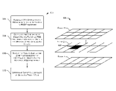
[0078] Fig. 6 further illustrates a flow diagram of an illustrative process
604 for
determining a target floor for zonal localization. At 606, a WiFi sample 206
is received from
a WiFi-enabled device 204 that is submitting a location query. This WiFi
sample 206
includes all WiFi APs 104(1)-(P) in its view (i.e., in range) and an RSS
fingerprint detailing
the RSS measurements at the WiFi-enabled device 204 corresponding to each WiFi
AP 104
in view.
[0079] At 608, the zone selection component 226 calculates a likelihood of
observing the
reported RSS fingerprint in individual ones of the multiple zones of the area
600. In some
embodiments, unlikely zones are pruned away to consider only those zones in a
candidate
set using only the histograms of the candidate zones.
[0080] At 610, the zone selection component 226 selects a target zone 602
among multiple
available zones of an area 600 that maximizes the likelihood of observing the
reported RSS
fingerprint in the received WiFi sample 206. At 612, a target floor is
determined based on
the selected target zone 602.
[0081] Fig. 7 is a flow diagram of an illustrative process 700 that
compensates for device
gain diversity. That is, different WiFi-enabled devices 204(1)-(N) tend to
report different
WiFi signal strength measurements (i.e., different sensitivity) even at the
same location.
Such device gain diversity among different WiFi-enabled devices 204(1)-(N)
affects the
model-based localization process, including which zone is to be selected as
the target zone.
The training samples in the survey data 212 may also be affected by device
gain diversity if
different devices are used to collect training samples for model training.
[0082] At 702, a RSS measurement from a WiFi-enabled device 204 is shifted by
multiple
gain offset values in a range of possible gain offsets. For example, a gain
offset range of -
20dB to +20dB may be used as the gain offset range, and a given RSS
measurement in a
WiFi sample 206 is then offset iteratively across the range of possible gain
offsets. For
example, one shift may offset the measured RSS by -20dB, while the next shift
may offset
the measured RSS by -19dB, and so on, until the last shift offsets the
measured RSS by
+20dB.
[0083] At 704, each shifted RSS measurement is analyzed with respect to the
likelihood
of observing the respective shifted RSS measurement in individual ones of the
multiple
zones of the area 100, and the zone that maximizes the likelihood of observing
the shifted
RSS is selected. At 706, the gain offset corresponding to the maximum among
all of the
CA 02938864 2016-08-04
WO 2015/126606 PCT/US2015/014101
likelihoods from each shifted RSS measurement is selected at 706 as the gain
offset for the
received RSS measurement. In some embodiments, the zone selected at 704 may be
the
target zone for purposes of localization, such as the target zone selected at
404 of the process
400 of Fig. 4. In this scenario, the gain offset may be used during a
localization process,
such as the process 400 of Fig. 4.
[0084] The environment and individual elements described herein may of course
include
many other logical, programmatic, and physical components, of which those
shown in the
accompanying figures are merely examples that are related to the discussion
herein.
[0085] The various techniques described herein are assumed in the given
examples to be
implemented in the general context of computer-executable instructions or
software, such
as program modules, that are stored in computer-readable storage and executed
by the
processor(s) of one or more computers or other devices such as those
illustrated in the
figures. Generally, program modules include routines, programs, objects,
components, data
structures, etc., and define operating logic for performing particular tasks
or implement
particular abstract data types.
[0086] Other architectures may be used to implement the described
functionality, and are
intended to be within the scope of this disclosure. Furthermore, although
specific
distributions of responsibilities are defined above for purposes of
discussion, the various
functions and responsibilities might be distributed and divided in different
ways, depending
on circumstances.
[0087] Similarly, software may be stored and distributed in various ways and
using
different means, and the particular software storage and execution
configurations described
above may be varied in many different ways. Thus, software implementing the
techniques
described above may be distributed on various types of computer-readable
media, not
limited to the forms of memory that are specifically described
Conclusion
[0088] In closing, although the various embodiments have been described in
language
specific to structural features and/or methodological acts, it is to be
understood that the
subject matter defined in the appended representations is not necessarily
limited to the
specific features or acts described. Rather, the specific features and acts
are disclosed as
example forms of implementing the claimed subject matter.
21