Note: Descriptions are shown in the official language in which they were submitted.
CA 02940400 2016-08-22
WO 2015/134142
PCMJS2015/014400
DYNAMIC WIDE-AREA EARTH THERMAL PROPERTIES AND EARTH AMBIENT
TEMPERATURE DETERMINATION SYSTEM
BACKGROUND
I. Field of the Invention
This invention is related to a dynamic wide-area subsurface earth thermal map,
which can
improve the accuracy of underground power cable ratings in general as well as
dynamic rating
io systems and fluid leak detection systems for power cables in particular.
A dynamic wide area
subsurface earth map can also be utilized to improve the performance of oil
and gas pipeline
monitoring and leak detection systems, heat pump analysis, etc.
2. Description of the Related Art
The electrical power transmission capability of underground cables is limited
by the maximum
allowable conductor temperature. If the conductor temperature exceeds the
maximum allowable
conductor temperature, the cable dielectric will be damaged and deteriorate
and ultimately fail.
The conductor temperature results from heat generated by the cable and the
ability of the
surroundings to dissipate this heat, thus raising the temperature above earth
ambient temperature
at the depth of the cable.
Typically, the worst-case earth thermal conditions are estimated and used to
calculate the "static"
or "book" rating for underground cables. Generally, the conservative and worst-
case thermal
conditions are not realized in practice and the underground cable current
capacity is higher than
the conservative "book rating" using estimated parameters.
How efficiently the surroundings (native soil, thermal backfill, or concrete
duct bank) can take
heat away from the cable is determined by the soil temperature, soil thermal
resistivity, and soil
volumetric heat capacity. One way to obtain soil temperature is to measure it
with discrete
temperature sensors buried in the ground. Soil thermal resistivity and
volumetric heat capacity
can also be measured in situ by commercially available instruments. However,
since it is costly
CA 02940400 2016-08-22
WO 2015/134142 PCMJS2015/014400
to install temperature sensors in the ground and to maintain and repair them,
discrete earth
temperature sensors are usually limited to only a few locations for a typical
power cable system
and usually only for higher voltage heavily loaded circuits. Therefore
heretofore arbitrary
assumptions must be made regarding earth temperatures between discrete
measurement points.
s Discrete measurement points are also subject to failure, and without a
reliable means to replace
this data, real-time dynamic systems can be seriously compromised. Taking
discrete soil samples
several feet below the ground surface for thermal resistivity and volumetric
heat capacity
measurements is also expensive and measurements can be unreliable due to the
fact that thermal
resistivity and volumetric heat capacity change with soil temperature and
weather dependent
io moisture content. In addition, soil thermal properties can change along
the cable route.
In recent years, Distributed Temperature Measurement Systems (DTS), which
provide a thermal
profile along a fiber installed under the cable jacket in adjacent ducts or
otherwise along the cable
route have also been utilized-either alone or in combination with discrete
temperature sensors.
More efficient and practical ways to more closely estimate soil temperature,
soil thermal
resistivity, and soil thermal volumetric capacity without installing,
maintaining and reading a
large quantity of underground sensors is needed to operate underground power
systems safely
which are typically spread out over a large geographical area(cities),
reliably, and efficiently.
Disclosed is a system that estimates soil temperatures as a function of depth
below the surface
over a wide area using an iterative process to "identify" the soil temperature
using a minimum of
sub-surface soil temperature measurement data in conjunction with weather data
from weather
stations or weather services. In the process this system also uses an
iterative process to "identify"
soil thermal resistivity and soil thermal capacitance which are also used by
the dynamic modeling
system. The system continuously "identifies" or updates the three parameters:
soil temperature,
soil thermal resistivity, and soil thermal volumetric heat capacity in real-
time. With these real-
time data, a large geographical dynamic thermal contour map at any depth can
be created to aid
power utility companies and other users in rating their underground power
cable systems more
2
CA 02940400 2016-08-22
WO 2015/134142 PCMJS2015/014400
accurately and in real-time in a wide geographical area utilizing a limited
number of
weather/earth/load real-time measurements and data.
One method for assessing underground cable ratings for a discrete cable system
based on
Distributed Temperature Sensing (DTS) is presented in an article entitled
"Assessment of
Underground Cable Ratings Based on Distributed Temperature Sensing", IEEE
Transactions on
Power Delivery, October 2006 by H.J. Li et al. Hot spots of the power system
are identified and
located with the DTS sensor. Information and data on cable construction and
circuit installation
on the hot spots is then collected. Cable loading and DTS temperature data is
collected for
io estimating the unknown parameters such as the soil thermal resistivity.
The Finite Element
Method (FEM) technique is utilized for solving two dimensional differential
thermal equations to
obtain the final rating results.
Another model for estimating earth ambient temperature using dynamic weather
data input is
proposed in an article entitled "Method for Rating Power Cables Buried in
Surface Troughs",
IEEE Proc-Gener, Transm, Distrib, Vol, 146, No. 4. July 1999 by P. L. Lewin et
al. Earth
ambient temperature is calculated using weather data such as, ambient
temperature, wind speed,
solar intensity, etc based on assumed constant thermal parameters.
However, thermal parameters are not updated (or "identified") continuously in
either of the
above references. In the real world, these parameters change with
environmental conditions. For
instance, rain can increase moisture content in the soil resulting in a lower
thermal resistivity.
SUMMARY OF THE DISCLOSURE
Advantages of the disclosed techniques include providing a dynamic as well as
more accurate
systems, devices, and methods of determining the real-time thermal conditions
and properties of
the earth over a wide area where underground power cables and other devices
are buried to help
system owners utilize these systems more safely and efficiently. After the
earth thermal
conditions and properties are "identified", the maximum allowable power the
system can deliver,
i.e, the rating is calculated. The ratings calculated using earth conditions
determined by this
3
CA 02940400 2016-08-22
WO 2015/134142 PCMJS2015/014400
method may be higher or lower than the ratings based on the case of estimated
thermal conditions,
but they will be more accurate. Furthermore, the system can also compute
conductor temperature
in real-time and send alarms to the control center before the conductor
temperature exceeds the
allowable maximum operating temperature.
The disclosed techniques and calculations can be used to determine either
static ratings or
dynamic ratings for electrical conductor. A static rating provides a single
number for current
carrying capacity of an electrical cable for a given set of conditions -
ambient temperature, earth
thermal characteristics, etc. - associated with the conductor. A dynamic
rating is constantly
I() changing with changes in the set of conditions acting on the electrical
cable.
In one aspect, the method of determining earth sub-surface thermal
characteristics over an area
includes collecting real-time weather data and earth data for a plurality of
locations associated
with an underground electrical cable and calculating earth thermal properties
at the plurality of
locations based on the real-time weather data and the earth data by an
iterative process. The
calculated earth thermal properties at two or more of the plurality of
locations are interpolated to
determine interpolated earth thermal properties at another location associated
with the
underground electrical cable and a wide-area thermal property map created from
at least some of
the calculated earth thermal properties and the interpolated earth thermal
properties.
In another aspect, the method includes superimposing heat sources and heat
sinks affecting the
earth thermal properties associated with the underground electrical cable into
the wide-area
thermal property map and continuously providing real-time weather data and
earth data to
provide a wide-area dynamic thermal 3-dimensional map of earth thermal
properties at depths at
the plurality of locations. The earth thermal properties can include soil
volumetric heat capacity
and soil thermal resistivity.
The iterative process for calculating the earth thermal characteristics
includes, for one or more
selected locations from the plurality of locations, performing the steps of
calculating earth
ambient temperature data based on values of earth thermal properties and the
real-time weather
4
CA 02940400 2016-08-22
WO 2015/134142
PCT/US2015/014400
data and collecting real-time measured earth ambient temperature from earth
ambient
temperature measurement devices. The calculated earth ambient temperature data
is compared
with the measured earth ambient temperature data and an error value determined
based on the
comparison. Based on the determining step, values for the earth thermal
properties are adjusted
s and the calculated earth ambient temperature data is recalculated using
the adjusted values for
earth thermal properties. The process of comparing the calculated earth
ambient temperature data
with the real-time measured earth ambient temperature, adjusting the earth
thermal properties,
and recalculating the calculated earth ambient temperature data is repeated
until the error value is
within a predetermined value.
Power ratings including safe current carrying ampacities for the underground
electrical cable can
be determined based on the generated wide-area dynamic 3-dminesional map and
warning
signals can be generated when changes in earth thermal properties result in
changes in earth
thermal properties affecting the safe current carrying ampacity of the
underground electrical
is cable.
An advantage of the disclosed technique can be to estimate the large-area
earth ambient sub-
surface temperature profile using primarily weather data input with earth
parameters derived
from a limited number of weather stations equipped with sub-surface soil
temperatures alone, or
weather stations alone, or data from weather service providers.
Another advantage of the disclosed technique can be to provide a measurement
and calculation
procedure to derive earth parameters using real-time weather conditions and
earth temperatures.
Another advantage of the disclosed technique can be to calculate the cable
ratings based on the
derived earth properties and calculated and measured earth temperature.
Another advantage of the disclosed technique can be to build a wide-area earth
thermal contour
map at various depths based on the derived earth parameters and ambient air
and other weather
data input. The wide-area earth contour will allow power utility companies to
assess the status of
their underground power cable systems network in the wide area whether or not
circuits have
discrete temperature sensors.
5
X1799285
Another advantage of the disclosed technique can be to fully utilize "DTS"
systems and other
conductor or cable surface temperature measurements by establishing a virtual
earth ambient
thermal profile along the axis of the cable.
According to one aspect of the present invention, there is provided a method
of determining
.. earth sub-surface thermal characteristics over an area, comprising:
collecting real-time
weather data and earth data for a plurality of locations associated with an
underground
electrical cable; calculating earth thermal properties at each of the
plurality of locations based
on the real time weather data and the earth data by an iterative process;
interpolating the
calculated earth thermal properties at two or more of the plurality of
locations to determine
.. interpolated earth thermal properties at another location associated with
the underground
electrical cable; and creating a wide-area thermal property map from at least
some of the
calculated earth thermal properties and the interpolated earth thermal
properties.
According to another aspect of the present invention, there is provided a
method of calculating
power ratings, comprising: collecting real-time weather data and earth data
for a plurality of
locations associated with an underground electrical cable; calculating earth
thermal properties
at each of the plurality of locations based on the real time weather data and
the earth data by
an iterative process; interpolating the calculated earth thermal properties at
two or more of the
plurality of locations to determine interpolated earth thermal properties at
another location
associated with the underground electrical cable; creating a wide-area thermal
property map
from at least some of the calculated earth thermal properties and the
interpolated earth thermal
properties; superimposing heat sources and heat sinks affecting the earth
thermal properties
associated with the underground electrical cable into the wide-area thermal
property map;
continuously providing real-time weather data and earth data to provide a wide-
area dynamic
thermal 3-dimensional map of earth thermal properties at depths at the
plurality of locations;
.. calculating underground electrical cable power ratings including safe
current carrying
ampacities based on the wide-area dynamic 3-dimensional map; and generating
warning
signals when changes in earth thermal properties result in changes in earth
thermal properties
affecting the safe current carrying ampacity of the underground electrical
cable.
6
CA 2940400 2018-09-17
81799285
The various features are pointed out in the claims annexed to and forming a
part of the
disclosure. Advantages of the present invention are made clear during the
course of a detailed
description of the novel system set out herein below.
BRIEF DESCRIPTION OF THE DRAWINGS
.. FIG. 1 is a block diagram of the system according to the present invention
for dynamically
monitoring wide-area thermal properties by feeding real-time weather and earth
data using a
weather-based technique.
FIG. 2 is a diagram illustrating how earth conditions can be retrofitted for a
route that does not
have earth stations using measured weather data with the help of a Geographic
Information
System (GIS) engine.
FIG.3 is a diagram illustrating different types of temperature sensors and
earth trees.
FIGS.4A-4B are a diagram illustrating a weather-driven model that can be used
to calculate
earth ambient temperature with weather data input.
FIG.5 illustrates using a weather-driven model to estimate earth thermal
properties using
weather data and measured earth ambient temperature input.
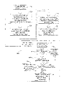
FIG.6 is a system diagram showing a system organization and application.
FIG.7 is a diagram showing an area with additional heat sources and sinks.
Weather/earth
stations are deployed for superimposing effect of heat sources/sinks on the
system.
6a
CA 2940400 2018-09-17
CA 02940400 2016-08-22
WO 2015/134142
PCMJS2015/014400
DETAILED DESCRIPTION
Hereinafter, the present invention will be described in detail with reference
to the above drawings.
It should be noted that terms and vocabularies used herein should not be
construed as limited to
general and dictionary meanings.
Referring to FIG.1, the present technique relates to a method for estimating
real-time wide-area
earth thermal conditions using real-time measured temperature data, weather
data. Weather data
and earth data are collected at step 110 in real-time by weather stations or
provided by weather
data service providers for locations related to an underground cable. Real-
time earth data come
to from earth ambient temperature measurement devices such as an earth tree
or Distributed
Temperature Sensors (DTS). Gathered weather data may be provided to the
weather driven
calculation module at step120 resulting in calculated earth ambient
temperature data by an
iterative process described in more detail below. By comparing the calculated
earth ambient
temperature data with the measured earth ambient temperature data in real-
time, earth thermal
properties can be identified for the locations with weather and earth data. In
step 130 the real-
time calculated values from nearby locations are interpolated so that a wide-
area thermal property
map can be created utilizing Geographic Information System (GIS) or some other
mapping
technique. Next in step 140 by superimposing heat sources and heat sinks
affecting the
underground cable into the map and continuously feeding real-time weather and
earth data into
the real-time model, a complete wide-area dynamic thermal 3-dimensional map is
achieved,
which in step 150 can be used for applications such as power cable ratings,
system planning, pipe
fluid leak detection. etc. With real-time earth conditions known, real-time
cable ratings can be
calculated. Warning signals can be generated upon the occurrence of dangerous
earth conditions
due to, for example, extremely dry and hot weather. In response, underground
power delivery
systems can be operated for maximum safe ampacities (current carrying
capacity).
As discussed above, the weather-driven method for determining earth thermal
properties in step
120 is achieved by an iterative process 160. In the iterative process real-
time weather data are
collected at step 162. The real-time weather data are provided at step 164 for
a location to a
weather-driven calculation for determining an earth ambient temperature at
step 166. At step 168
7
CA 02940400 2016-08-22
WO 2015/134142
PCMJS2015/014400
actual real-time measured earth ambient temperature is collected from earth
stations including
earth trees and/or DTS for the location. At step 170 the actual real-time
measured earth ambient
temperature collected in step 168 is compared to the calculated earth ambient
temperature
determined in step 166. If the difference between the real-time temperature
and the calculated
temperature is not within a predetermined error value then the earth thermal
properties, including
values for soil volumetric heat capacity and soil thermal resistivity, used in
the weather-driven
calculation are adjusted at step 172. This iterative comparison at step 170
continues until the
real-time earth ambient temperature and the calculated earth ambient
temperature are within the
predetermined error value. If so, at step 174 the weather-driven method
identified the real-time
io earth thermal properties. A method for calculating earth ambient
temperature using the real-time
weather data and the earth thermal properties is discussed further in regards
to FIG. 4.
Global Earth Condition Estimation
Before turning to a description of the details of the system it is helpful to
understand the concept
is of wide area earth condition estimation and how such conditions can
affect an underground
power delivery system. The underground power delivery system is widely
distributed and due to
complex installation conditions and the fact that the system is buried
underground it can be
extremely expensive to install and monitor temperature sensors to establish
the appropriate earth
ambient temperature throughout the whole system. High Voltage transmission
cable systems can
zo have a number of discrete temperature sensors installed on the cable
jacket or cable pipe and
infrequently a remote earth temperature sensor. The bulk of the underground
Transmission and
Distribution system is the Distribution component at voltages below 100 kV and
standard
practice is not to install sensors on the cable jacket, etc. Temperature
sensors, such as
thermocouples, are installed at selected locations along the cable route
identified by analyzing
25 plan profile drawings augmented by soil stratigraphy information and
generic or discrete soil
thermal property survey data to identify where critical hot spots may exist.
Without a wide-area
earth estimation model, most sections of the underground power cable system
lack temperature
and soil thermal property data for assessing their ampacities and rely almost
exclusively on
estimates that create significant uncertainty and can lead to catastrophic
failure at the most
30 inappropriate time (contingent loads during environmentally extreme
dry/hot conditions). As an
8
CA 02940400 2016-08-22
WO 2015/134142 PCMJS2015/014400
example, referring to FIG. 2, cable route 1 has existing earth stations at
locations A, E and G.
Cable 2 has no earth stations and cannot be easily retrofitted due to below
grade permitting and
route access. In contrast, above grade weather stations can be readily added
within the region of
interest at locations B, C, D and F. Using a commercial GIS engine, a
relatively detailed thermal
contour map of the region can be generated using interpolation algorithms. Not
only is an
improved thermal profile of cable 1 obtained, but a reasonably accurate
thermal profile of cable 2
is generated for the underground power delivery system. There are several
major factors that
determine the system ampacity, such as cable current loading, cable
construction, installation,
thermal properties of the surrounding soil, the ambient temperature, etc. Of
these factors, soil
to thermal properties and ambient temperature vary continuously with
weather. In other words, the
system ampacity is dynamic. With the wide-area earth condition estimation
system, soil thermal
properties and ambient temperature in a large area can be estimated thus the
ampacity of the
various discrete power cable systems in that wide area can be assessed in real-
time even when
there are no temperature sensors for certain routes or temperatures sensors
are out of service.
is Furthermore, by accumulating data for a period of time, the thermal
properties of areas monitored
can be identified, and this data can be provided to optimize cable design
layout, construction and
installation to maximize cable ampacities of new power cable systems.
Temperature Sensors
20 Point temperature sensors as well as distributed temperature sensors can
be used for earth
temperature measurements. Other types of sensing devices can also be used for
temperature
measurements for the earth condition estimation.
Referring to FIG. 3, an advantage of point temperature sensing devices 304 is
that such sensors
25 can be easily installed on critical locations and several point
temperature sensors 306a. . . 306n
can be installed at one particular location at different depths forming an
"earth tree" 306 to
collect soil temperatures at different depths below ground level 302. The
condition estimation
system is more robust and accurate with point temperature sensors 304 than
distributed
temperature sensors (DTS) because there are multiple sensors 306a. . . 306n at
one location.
30 Additionally, the deployment of temperature sensors at different depths
makes thermal property
9
CA 02940400 2016-08-22
WO 2015/134142
PCMJS2015/014400
estimation more accurate because heat flow can be observed more closely
leading to more
accurate determination of thermal property parameters than with a DTS system.
Also, flexibility
is another advantage for point temperature sensors when dealing with critical
locations. Point
temperature sensors can be installed at different depths and different spacing
relative to the cable
312 surface to more closely define and monitor a critical hot spot.
One advantage of DTS 308, 310 is that such systems can monitor the temperature
profile
continuously along the whole cable route. Cable hot spots can be identified
and monitored from
the distributed temperature profile. A disadvantage of a DTS system is that
the DTS measures
io the cable core or cable shield. While another fiber can be installed in
an empty duct or in the
cable trench, the relationship of the additional fiber to ambient earth
temperature is likely to be
unknown. So a cable rating is still based on an assumed earth ambient
temperature and the
thermal resistance from cable surface to earth ambient is assumed. A second
disadvantage of the
distributed temperature sensors is that it is prone to a common mode failure;
that is, once the
DTS sensor fails, the estimation system will stop.
To take advantage of both types of temperature sensors - DTS and point
temperatures sensors -
for cable routes where the distributed temperature sensor is installed, the
distributed temperature
sensor is used for establishing the temperature profile of the cable along the
cable route. From
.. the temperature profile, hot spots can be identified. Additional point
temperature sensors can be
installed at these hot locations for discrete soil thermal condition
estimation. If these point
temperature sensors are monitored in real-time, then the soil thermal property
can be identified in
real-time at these locations. However, there is no assurance these thermal
cross sections will
remain the hottest, that is, the locations that are most likely limiting cable
ampacity. If the DTS
measured hot spot moves due to changes in cable loading, of soil moisture,
temperature, or
adjacent heat source or sink, then in the absence of a wide area earth model
additional point
temperature sensors may need to be installed to establish the hot spot thermal
property in real-
time. The point temperature sensors if not at the DTS identified hotspots can
be calibrated and
used as a default for the system if the DTS fails or is otherwise out of
service.
10
CA 02940400 2016-08-22
WO 2015/134142
PCMJS2015/014400
Weather-Based Wide-Area Earth Ambient Temperature and Thermal Property
Estimation
The earth ambient temperature is a component of a dynamic rating system. When
an earth sensor
fails or is electrically noisy, the systems may be compromised. The present
technique discloses a
method for replacing missing or noisy earth ambient data using a weather-
driven model in
conjunction with available data from adjacent earth condition estimation
systems. Information
can be interpolated between earth estimation systems (thus the term 'Wide-
Area') rather than
depend strictly on isolated earth sensors associated with each earth condition
system. The
reliability and accuracy of the earth condition estimation system could be
substantially improved
by using interpolation formulae thus providing continuous subsurface earth
temperature data over
io .. a wide area.
Description of the Dynamic Earth Temperature Model
Earth (soil) ambient temperature annual and daily fluctuations are determined
mainly by
variations in air temperature, solar radiation, wind speed, and cloud covering
ratio. Normally,
heat is transferred into the earth in summer and out of the earth in winter.
A one-dimensional distributed parameter model such as depicted in Figure 4A is
sufficiently
accurate for the temperature estimation provided that the vertical increments
are small. Finite
difference or finite element techniques could also be used. The model consists
of a square heat
flow tube extending vertically from the earth's surface to some distance below
the surface where
about 99% of the cyclic thermal wave has been dissipated and can be considered
a constant
temperature, Te. This depth is typically in the 8-15 meter range. The vertical
rectangular
surfaces of the heat flow tube can be considered adiabatic as adjacent soil
properties and
conditions are not expected to vary much. The heat balance of any incremental
element (z) can
be written as:
dT z
= ant Qc = ant 4- z dt (1)
Where:
Qin = heat flow into the element, W
11
CA 02940400 2016-08-22
WO 2015/134142
PCMJS2015/014400
Qout = heat flow out of the element, W
= heat absorbed by the thermal capacity of the element, W
Cz = thermal capacitance, W-s/ C
T, = temperature of the element, C
t = time,
Thereby a distributed ladder network of Figure 4B can be generated where:
PAz
R4= C, = CV (2a, 2b)
A
lo Where:
p = thermal resistivity of element, C-m/W
A = Ax * Ay = cross-sectional area of element, m2
Az = height of element, z
Cõ = volumetric thermal capacity, w¨ s
C ¨ tn3
is V = Ax * Ay * Az = volume of element, m3
A system of linear differential equations that describes the model can be
written as follows:
= 1 7i =7X¨ )+T2( )+AH
RICI RIC1
H, = Hsa H404 + Rh,
(3a)
i = 2 . . . (n - 1)
= 1 1 1 , 1 ,
20 T, = 1 R, ,C, R,C,+ r+tl-R,C, (3b)
= 1 1 1 T
T=-T(
)+Tn(¨ Rõ_,Cõ RõC,,)+ R,,C, (3c)
where is the derivative dTti/dt which is approximated by AT,i/At , and Fis is
the heat flowing in
and out of the surface including 11401, solar heat, H., convective heat flux,
and F11, long-wave
12
CA 02940400 2016-08-22
WO 2015/134142
PCMJS2015/014400
radiation heat. A solution for the present temperature at each node T0 is then
obtained by adding
to the temperature array Tn..i of the previous time step. The method of
integrating or marching
forward is dependent on the accuracy desired. However, a two-step enhanced
Euler technique
may be sufficiently accurate. The procedure is to march two steps forward and
average the
results:
(k, +Oh
T T
)1,12 )1,t1 '
2
,---Tn,n; (4)
k2 = n,11+11;
h = t2 ¨
More accurate integration methods such as a 6 step Runge-Kutta procedure could
also be used.
The conditions at the earth's surface also can be considered. The dominant
driving function is
io the ambient air temperature. Additional factors are solar heat loading
Qs, and radiation Qr. and
wind convection. Radiation, sometimes referred to a "long wave radiation"
tends to cool the
earth at nighttime when cloud cover is non-existent or trap heat when cloud
cover is high. The
wind velocity (9w) can be obtained via an anemometer. The ambient air
temperature Ta is easily
obtained with a shielded temperature sensor incorporated in the weather
station. Solar radiation
can be measured directly by a pyranometer incorporated in the weather station.
This is preferred
over a mathematical prediction for the particular latitude and longitude as it
accounts for cloud
interference or blockage by nearby structures. The long wave radiation can be
measured by
radiation meters pointed at both the sky and the ground surface or can be
calculated using the
following equation:
Hh,= p(Ta411. _ rg.t, ) X-0.2
(170.9-0.195137') (7)
0.8
where Tair is the ambient air temperature, Tgr is the ground surface
temperature, f3 is the
Boltzmann constant, and X is the daily cloud cover factor. Convective heat
flux can be
computed using the following equation:
13
CA 02940400 2016-08-22
WO 2015/134142
PCMJS2015/014400
Hem =k(T gr Tair)
(8)
k=6+4.6V,
Note in the above Equations 7 and 8, some parameters may need adjustments to
get best results,
.. which can be done after some data are accumulated. Weather data can be
obtained directly from
weather station measurements or from weather service providers. Cables are
frequently buried
under pavement and properties of the pavement may be included in the first
several elements of
the model. This is readily accomplished by changing the properties of the
elements
corresponding to the pavement geometry. If knowledge of certain soil strata is
also available
io then those properties could be modified in layers.
Temperature Estimation Initialization
The model is constructed by initially using measured earth parameters, namely
resistivity (p) and
volumetric thermal capacity (C,) or previously estimated earth parameters
using the method
described below. When installing the subsurface earth tree it may be
beneficial to retain soil
samples and perform laboratory analysis to determine the values of p and C. In
the absence of
measured parameters, guidelines for selecting these parameters can be found in
many published
sources (Appendix B of the National Electrical Code (B.3 1 0.1 5(B)(2)), G. S.
Campbell
Biophysical Measurements and Instruments, Measurement of Soil Thermal
Properties and Heat
.. Flux, Volumetric heat capacity, Wikipedia). A suggested range of values are
shown in Table 1:
TABLE 1
Thermal Properties Dry Wet
Thermal resistivity 1.2 0.6
(Km/W)
Volumetric heat capacity 1.2 4.18
(MJ/Km3)
An initial deep earth temperature T, can be estimated from historical weather
information and the
average yearly air temperature can be used as an initial estimate. It is
possible to initialize all
14
CA 02940400 2016-08-22
WO 2015/134142
PCMJS2015/014400
nodes in the model at the deep earth temperature and let the parameter
adjustment feedback loop
automatically adjust parameters. However, due to long time constants it may
take several months
or up to V2 year before the modeled temperatures begin tracking the measured
values. Another
method of initialization is to adjust air temperature, solar heat loading and
radiation so that the
calculated temperatures closely match the measured subsurface temperatures
when a steady state
solution of Equations (3) is obtained.
Adaptive Earth Themial Property Identification Method
The earth model described above can not only be used to estimate the earth
ambient temperature
to but also used for estimating earth thermal properties. An adaptive or
learning based modeling
scheme is used to continuously update the model such that weather dependent
parameters are
considered. The scheme is diagrammatically depicted in FIG. 5. The forcing
functions that drive
the model, consisting of measured air temperatures, wind speed, solar input
and radiation are
provided to the model. The data can be processed according to Equations (3) to
compute earth
temperatures at each incremental node at each time step. The computed earth
temperatures can
be compared to measured temperatures below the ground surface that correspond
to calculated
temperatures at a particular location, if the temperatures agree, then the
calculated earth
temperatures can be passed along to the GIS engine for contour mapping and to
dynamic rating
systems for dynamic rating calculations, If the temperatures do not agree
within a certain desired
zo or allowable predetermined error value, then model earth property
parameters may be adjusted to
minimize the difference between the calculated and measured earth ambient
temperature at the
particular location. The process includes separating the soil thermal
resistivity parameters from
the soil volumetric heat capacity parameters. The thermal resistivity
parameters are modified so
the computed temperatures seek the magnitudes of the measured points and the
heat capacity
parameters are adjusted so the rate-of-change of the computed temperatures
correspond to the
rate-of-change of the measured points. The feedback loop can include
sufficient dampening and
dead band such that overshoot and oscillation does not occur.
CA 02940400 2016-08-22
WO 2015/134142 PCMJS2015/014400
Construction of a Weather-Based Wide Area Earth Thermal Condition Estimation
System
The wide area scheme is constructed of an array of monitoring stations. These
will generally
consist of weather and earth stations (WES), earth stations (ES) and weather
stations (WS). The
weather station may also be replaced by data streaming from weather data
service providers if
available. Fig. 6 illustrates an implementation of a weather-based wide area
earth thermal Si
condition estimation system. An ES 602 includes an earth tree 602a measuring
subsurface
temperatures at several depths that usually correspond to the maximum range of
cable depths. A
remote terminal unit 602b can be used to transmit the earth tree data to a
local earth condition
estimation unit 608. A WS 604 includes an air temperature sensor, a
pyranometer - an
actinometer also known as a solarimeter, an anemometer and a long wave
radiation sensor
measuring long wave radiation coming from both the sky and the earth 604a. A
remote terminal
unit 604b can be used to transmit the earth tree data to the local earth
condition estimation unit
608. The WES 606 includes features of both WS 606a and ES instrumentation
606c. A remote
terminal unit 606b can be used to transmit the earth tree data to a local
earth condition estimation
is unit 608. At WES stations a more comprehensive dynamic modeling
procedure can occur based
on local data than can be obtained from either a ES or WS alone. At locations
having an ES, the
ES dynamic model obtains weather data from a nearby WS and WES stations. At
locations
having WS, the WS station completes dynamic analysis by obtaining updated soil
parameters
from a nearby WES and ES stations. In the WS based model the parameter
adjustment feedback
loop is disabled. In terms of sharing information, a system of weighting may
be employed that
ranks information based on (1) closeness or geophysical similarity of
locations, and (2) strength
or confidence of the calculated parameters, including soil volumetric heat
capacity, soil thermal
resistivity, and earth ambient temperature. The strength of the calculated
parameters is highest
for WES stations followed by ES and WE stations. Information from real-time
commercial or
government weather services such as SCADA 614 can also be integrated into the
weather system
data.
Referring agains to FIG. 6, with these sensing locations (earth stations,
weather stations, and/or
earth-weather stations) installed in a wide area, the thermal properties and
ambient temperatures
at these locations can be determined. For the areas where there are no sensing
locations, thermal
16
CA 02940400 2016-08-22
WO 2015/134142
PCMJS2015/014400
properties and ambient temperature can be estimated by interpolating values
from nearby
measured locations. In this manner thermal condition data can be determined
for a wide area.
With map engines, such as a GIS engine 610, data can be displayed to form an
underground
thermal contour map 612 as shown in FIG. 2. Cable ratings for underground
cables in the wide
area network and resultant display and warning signals for such cables 616 can
be cased on the
calculated underground thermal contour map and available real-time commercial
or government
data.
Superposition of Heat Sources and Heat Sinks
io .. Referring to Figs. 2 and 7, when constructing a real-time Weather-Based
Wide Area Earth
Thermal Condition 3-dimensional map factors such as additional heat sources -
which tend to
add heat, or heat sinks, which tend to remove heat, from an underground cable,
also may be
considered. Heat sources and sinks include, for example, other nearby cables,
lakes, rivers, etc.
The heat sources and heat sinks can affect the current carrying capacity of an
underground cable.
A heat source can heat up earth leading to a higher earth ambient temperature
and higher soil
thermal resistivity at affected areas whereas the heat sink can cool the earth
leading to a lower
earth ambient temperature and lower soil thermal resistivity. Fig. 7
illustrates three underground
cables, Cable A, Cable B, and Cable C. To consider the effect of a heat source
such as a cable, a
weather station, earth station, or weather earth stations can be deployed at
locations close to the
.. cable. For example, each of Cables A-C has a number of WS , ES, or WES
702a, õ 702k at
locations adjacent the respective cable runs. A WS, ES, or WES 702e is
deployed near a lake
704 as the lake can affect the soil parameters associated with Cable B. In a
similar manner, a WS,
ES, or WES 702b is deployed at a location on Cable A that may affected by a
nearby factory 706.
With the real-time data from these stations, earth ambient temperatures can be
measured and
.. earth thermal properties can be determined using the algorithm described
above and shown in
Fig 5. These results can be used as input to map engines and using the
interpolation algorithm a
revised real-time Weather-Based Wide Area Earth Thermal Condition map
considering heat
sources and heat sinks can be obtained. The same thing can be done to a heat
sink such as a
water pipe by deploying measurement stations at locations close to the water
pipe for measuring
.. affected earth ambient temperatures and establishing earth thermal
properties. Subsequently
17
CA 02940400 2016-08-22
WO 2015/134142 PCT/1JS2015/014400
utilizing the map engines and interpolation algorithm, the heat sources and
heat sinks can be
superimposed onto the Wide Area Earth 3-dimensional Thermal Condition map
resulting in a
real-time Weather-Based Wide Area Earth Thermal Condition map with the weather
conditions
as the driving force. The 3-dimensional map displays both earth ambient
temperatures and earth
thermal properties dynamically in the wide area and can be used for power
cable ratings and
other applications. The 3-dimensional map may be used by utilities to help
operators monitor
their underground power systems in real-time. Wide-area thermal properties and
ambient earth
temperature data can also be used to calculate dynamic ampacity of underground
power devices.
When values of the thermal properties or ambient temperature exceed the
predefined value,
to warning signals are created and sent to the controlling center to
control possible damages.
Although preferred embodiments of the present invention thereof have been
disclosed and
described in details herein, it is to be understood that this invention is not
limited to those precise
embodiments. Other modifications and variations may be effected by one skilled
in the art
without departing from the spirit and scope of the invention as define by the
appended claims.
18