Note: Descriptions are shown in the official language in which they were submitted.
CA 02940810 2016-08-25
WO 2015/131016 PCMJS2015/017930
AUTOMATIC METHOD FOR THREE-DIMENSIONAL STRUCTURAL
INTERPRETATION OF BOREHOLE IMAGES ACQUIRED IN HIGH-
ANGLE AND HORIZONTAL WELLS
Cross Reference to Related Applications
[0001] Priority is claimed from U.S. Provisional Application 61/946,662
filed on
February 28, 2014.
Statement Regarding Federally Sponsored Research or Development
100021 Not Applicable.
Background
100031 This disclosure is related to the field of well logging instruments
having sensors
that make measurements usable to generate an equivalent of a visual image of a
wall of a
wellbore through which the instrument is moved. More specifically, the
disclosure
relates to methods and systems for processing such measurements to
automatically
identify certain types of geologic features from the measurements. This
section is
intended to introduce the reader to various aspects of the technical field of
the disclosure
that may be related to the subject matter described and/or claimed below. This
section is
believed to be helpful in providing the reader with background information to
facilitate a
better understanding of the various aspects of the present disclosure.
Accordingly, it
should be understood that these statements are to be read in this context, and
are not to be
construed as admissions of prior art.
[0004] Well logging instruments are used in wellbores drilled through
subsurface
formations to make, for example, measurements of selected physical parameters
of the
formations to infer properties of the formations surrounding the wellbore and
the fluids in
void spaces in the formations. Well logging instruments known in the art
include
electromagnetic tools, nuclear tools, acoustic tools, and nuclear magnetic
resonance
CA 02940810 2016-08-25
WO 2015/131016 PCMJS2015/017930
(NMR) tools, though various other types of tools for evaluating formation
properties are
also known.
[0005] Well logging instruments may be deployed in and moved along the
interior of a
wellbore on an armored electrical cable ("wireline") after the wellbore has
been drilled.
Present versions of such "wireline" well logging instruments are still used
extensively.
However, as the demand for information during the drilling of a wellbore
continues to
increase, measurement-while-drilling (MWD) tools and logging while drilling
(LWD)
instruments have been developed to fulfill such demand. MWD tools are
generally
defined as those making measurements of drilling parameters such as axial
force (weight)
on a bit used to drill the wellbore, torque applied to a drill string,
wellbore temperature,
wellbore fluid pressure, and well trajectory direction and inclination. LWD
instruments
are generally defined as those which make formation parameter measurements
such as
electrical resistivity, fractional volume of pore space in the formations
("porosity"),
acoustic velocity, density, neutron hydrogen index and/or capture cross-
section and NMR
relaxation time distributions, among other measurements. MWD and LWD
instruments
often have sensors similar in nature to those found in wireline instruments
(e.g.,
transmitting and receiving antennas, sensors, etc.), but MWD and LWD tools are
designed and constructed to operate in the harsh environment of wellbore
drilling.
[0006] Well logging measurements may be processed to form images. Such
processing
may include plotting values of one or more well logging measurements in the
form of
gray scale or color scale with respect to both axial position in the wellbore
(measured
depth) and circumferential orientation within the wellbore. Logging-while-
drilling
(LWD) images acquired in highly inclined or horizontal wellbores may be
characterized
by various features that are sensitive to formation geologic structure near
the wellbore. In
well log data processing known in the art, image features commonly referred to
as
"sinusoids", "bulls-eyes", or "reverse bulls-eyes" may extracted from the
images
manually. However, manual feature extraction is time consuming and prone to
user bias.
This is of particular concern in highly inclined and/or horizontal wells,
where small errors
in determining formation layering angle with respect to horizontal
("structural dip") may
translate into large errors in calculated formation reservoir volumetrics.
See, for
2
CA 02940810 2016-08-25
WO 2015/131016 PCT/US2015/017930
example, Q. R. Passey et al., Overview of High-Angle and Horizontal Well
Formation
Evaluation: Issues, Learnings, and Future Directions, SPWLA 46th Annual
Logging
Symposium, June 26-29, 2005. Furtheimore, "bulls-eye" features have been
observed
extending for hundreds of feet in measured depth (axial length along the
wellbore). It is
therefore important to account for changes in both wellbore trajectory
inclination and
geodetic or geomagnetic direction ("azimuth"), and formation dip/azimuth, in
the
structural interpretation of such formations.
Summary
[0007] A summary of example embodiments disclosed herein is set forth
below. It
should be understood that these embodiments are presented only to provide the
reader
with a brief summary of the subject matter and that the disclosed embodiments
are not
intended to limit the scope of this disclosure. The disclosure may encompass a
variety of
aspects and embodiments that may not be set forth herein.
[0008] The present disclosure sets forth example methods for automatic
structural
interpretation of bulls-eye and sinusoidal features observed in logging while
drilling
(LWD) images acquired in highly inclined and/or horizontal wellbores. In
accordance
with example embodiments, the method is based on an automatic workflow for
extracting
smooth contours from LWD images that demarcate boundaries of structural
features,
followed by projection of the boundary contours to three-dimensional (3D)
point clouds
in the wellbore coordinate system for structural interpretation. The method
may
characterize both sinusoidal features and bulls-eye features, taking into
account variations
of formation dip/azimuth, or wellbore inclination/azimuth, on the topology of
a structural
feature. Compared to methods known in the art prior to the present disclosure,
methods
described in the present disclosure may have a processing time of as little as
a few
seconds for a hundred feet (30 meters) of wellbore image data. Accordingly,
example
methods disclosed herein may be sufficiently fast for use in real-time
analysis and
interpretation, or to provide constraints for physics-based well log data
inversion
processing.
3
81799404
[0009] In accordance with aspects of the present disclosure, the effect
of well logging
instrument eccentering on the accuracy of formation dip estimated from
sinusoidal features
may also be quantified. Based on a geometric model, it has been found that
logging
instrument eccentering perturbs the shape of an image of a geologic feature
from a simple
sinusoid. However, when eccentering is ignored, it has been observed that
errors in
estimated apparent relative dip and apparent azimuth are less than a few
tenths of a degree
for many highly inclined or horizontal well logging situations.
[0010] In one embodiment, a method includes acquiring an azimuthally
substantially
continuous wellbore image using a well logging instrument disposed in a
wellbore
penetrating a subsurface formation. The method includes using a processor to
process the
azimuthally substantially continuous borehole image for extraction of
contours, to group the
extracted contours into clusters corresponding to a single transition zone,
and to map the
extracted contours having a measured depth interval (axial extent) that is
greater than a
length-scale over which the dip of the subsurface formation varies to a three-
dimensional
space corresponding to a coordinate system associated with the wellbore.
Extracted contours
having a measured depth interval that is less than the length-scale over which
the dip of the
subterranean formation varies, using the processor to estimate relative
formation dip and
apparent azimuth based on a first harmonic approximation of a contour.
[0010a] In a further embodiment, there is provided a method comprising:
in real time
accepting as input to a processor an azimuthally substantially continuous
wellbore image
being obtained from a well logging tool moving along a wellbore penetrating a
subsurface
formation; in the processor, extracting contours from the substantially
azimuthally
continuous image; in the processor, grouping the extracted contours into
clusters
corresponding to a single transition zone; and in the processor, mapping the
clustered
contours having a measured depth extent that is greater than a length-scale
over which a dip
of the subsurface formation varies to a three-dimensional space corresponding
to a
coordinate system associated with the well; and in the processor, calculating
a dip and
azimuth of a layer boundary of the subsurface formation from the mapped
clustered contours
and at least one of storing and displaying the calculated dip and azimuth; and
interpreting
features observed in the display.
4
Date Recue/Date Received 2022-05-19
81799404
10010b] In a further embodiment, there is provided a method for
determining dip and
azimuth of a subsurface formation, comprising: moving a well logging tool
along an interior
of a wellbore penetrating the subsurface formation to generate a substantially
azimuthally
continuous image from measurements made by the well logging tool; in a
processor,
extracting contours from the substantially azimuthally continuous image; in
the processor,
grouping the extracted contours into clusters corresponding to a single
transition zone; in the
processor, mapping the clustered contours having a measured depth extent that
is greater
than a length-scale over which a dip of the subsurface formation varies to a
three-
dimensional space corresponding to a coordinate system associated with the
well; and in the
processor, calculating a dip and azimuth of a layer boundary of the subsurface
formation
from the mapped clustered contours and at least one of storing and displaying
the calculated
dip and azimuth; and interpreting features observed in the display.
[0010c] In a further embodiment, there is provided a system for
determining dip and
azimuth of a subsurface formation, comprising: a well logging tool for
obtaining an
azimuthally substantially continuous wellbore image while being moved along a
wellbore
penetrating a subsurface formation, a processor programmed to accept as input
thereto the
azimuthally substantially continuous wellbore image obtained using the well
logging tool;
the processor programmed to extract contours from the substantially
azimuthally continuous
image; the processor programmed to group the extracted contours into clusters
corresponding to a single transition zone; the processor programmed to map the
clustered
contours having a measured depth extent that is greater than a length-scale
over which a dip
of the subsurface formation varies to a three-dimensional space corresponding
to a
coordinate system associated with the well; and the processor programmed to
calculate a dip
and azimuth of a layer boundary of the subsurface formation from the mapped
clustered
contours and at least one of storing and displaying for interpretation the
calculated dip and
azimuth.
[0011] The brief summary presented above is intended to familiarize the
reader with
certain aspects and contexts of embodiments of the present disclosure without
limitation to
the claimed subject matter.
4a
Date Recue/Date Received 2022-05-19
81799404
Brief Description of the Drawings
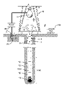
[0012] FIG. 1 shows an example wellbore drilling and LWD/WMD system
that
may be used in some embodiments.
[0013] FIG. 2 shows an example of topology of structural features
observed in
LWD images. The tracks show well azimuth, well inclination, simulated density
image, and curtain section formation model.
4b
Date Re9ue/Date Received 2021-06-28
CA 02940810 2016-08-25
WO 2015/131016 PCT/US2015/017930
[0014] FIG. 3 shows an overview of workflow for automatic structural
interpretation of
logging-while-drilling images.
[0015] FIG. 4 shows an example plot from step 4 of the workflow (Contour
Projection
and Dip Estimation), wherein contours are mapped to three-dimensional point
clouds,
and true dip and true azimuth of a planar feature are estimated by fitting a
plane to a point
cloud.
[0016] FIG. 5: shows from left to right and illustration of workflow steps
1-3 for a field
density image with sinusoidal features.
[0017] FIG. 6 shows an illustration of step 4 of the workflow for a field
density image
with sinusoidal features.
[0018] FIG. 7 shows from left to right an illustration of workflow steps 1-
3 for a field
density image with bulls-eye feature.
[0019] FIG. 8 shows an illustration of step 4 of the workflow for a field
density image
with a bulls-eye feature. The 3D projection of the bulls-eye, and the
corresponding dip
and azimuth are shown with the circled points on the right.
[0020] FIG. 9 shows from left to right, an illustration of workflow steps 1-
3 for a field
density image with a reverse bulls-eye feature.
[0021] FIG. 10 shows an illustration of step 4 of the workflow for a field
density image
with a reverse bulls-eye feature. The 3D projection of the reverse bulls-eye
feature and
the corresponding dip and azimuth are shown with circled points.
[0022] FIG. 11 shows results for a field resistivity image with sinusoidal
features.
[0023] FIG. 12 is a schematic illustration showing a definition of
eccentering parameters.
The azimuth of the instrument sensor, and the instrument touching angle, are
denoted by
O and (p respectively. The eccentering parameter e is defined as e--=(
\rbh rtoodlrbh, where
rbh is the radius of the cylindrical borehole and r is
the instrument radius. An
equivalent definition is e-t1(2rt00rFt), where t is the maximum standoff.
CA 02940810 2016-08-25
WO 2015/131016 PCT/US2015/017930
[0024] FIG.
13 shows graphically the effect of varying eccentering e and touching angle
cp on the parametric model 40) given by Eq. 8. In practice, an eccentering
e=0.25 may be
unrealistically large. For example, for an 8.25 inch diameter tool, e=0.25
corresponds to a
maximum standoff of t=2.75 inch, which is much larger than the typical
standoff
observed in practice.
[0025] FIG.
14: graphically shows sensitivity of first and second harmonics of the
parametric model 1(0) given by Eq. 8 to changes in the eccentering e (top
row), and
changes in the touching angle cp (bottom row). The first harmonic shows weak
sensitivity
to e or cp, while most of the sensitivity appears in the second harmonic. Thus
relative dip
and apparent azimuth estimated from the first harmonic (see Eqs. 6-7), as in
the
workflow, should be relatively insensitive to eccentering.
est
[0026] FIG.
15 shows error in estimated relative dip f3r resulting from applying Eq. 6 to
a contour 1(0) given by Eq. 8, for different values of eccentering e and
touching angle cp.
The error is defined as 113est¨r13r' and each pixel shows a worst error over
the range
70 <13r<90 , and ¨10 <aa<10 .
[0027] FIG.
16 shows the error in estimated apparent azimuth resulting from applying
Eq. 7 to a contour 1(0) given by Eq. 8, for different values of eccentering e
and touching
est
angle cp. The error is defined as aa ¨aa and each pixel shows a worst error
over the
range 70 <13r<90 , and ¨10 <aa<10 .
Detailed Description
[0028] One or
more example embodiments according to the present disclosure are
described below. The disclosed embodiments are merely examples of the
presently
disclosed subject matter. Additionally, in an effort to provide a concise
description of
such embodiments, all features of an actual implementation may not be
described in the
specification. It should be
appreciated that in the development of any such
6
CA 02940810 2016-08-25
WO 2015/131016 PCT/US2015/017930
implementation, as in any engineering or design project, numerous
implementation-
specific decisions may be made to obtain the developers' specific objectives,
such as
compliance with system-related and business-related constraints, which may
vary from
one implementation to another. Moreover, it should be appreciated that such
development efforts might be complex and time consuming, but would
nevertheless be a
routine undertaking of design, fabrication, and manufacture for those of
ordinary skill
having the benefit of the present disclosure.
[0029] When introducing elements of various embodiments of the present
disclosure, the
articles "a," "an," and "the" are intended to mean that there are one or more
of the
elements. The embodiments discussed below are intended to be examples that are
illustrative in nature and should not be construed to mean that the specific
embodiments
described herein are necessarily preferential in nature. Additionally, it
should be
understood that references to "one embodiment" or "an embodiment" within the
present
disclosure are not to be interpreted as excluding the existence of additional
embodiments
that also incorporate the recited features.
[0030] FIG. 1 shows a simplified schematic view of a wellbore drilling
system in which
various embodiments according to the present disclosure may be used. The
wellbore
drilling system shown in FIG. 1 may be deployed either on land or offshore. In
the
described drilling system, a wellbore 11 may be formed in subsurface
formations by
rotary drilling in a manner that is well known to those skilled in the art.
Some
embodiments can also use directional drilling.
[0031] A drill string 12 is suspended within the borehole 11 and has a
bottom hole
assembly (BHA) 100 which includes a drill bit 105 at its lower end. A surface
system
includes a platform and derrick assembly 10 positioned over the wellbore 11,
with the
platform and derrick assembly 10 including a rotary table 16, kelly 17, hook
18 and
rotary swivel 19. In a drilling operation, a drill string 12 is rotated by the
rotary table 16
(energized by means not shown), which engages the kelly 17 at the upper end of
the drill
string 12. The drill string 12 is suspended from a hook 18, attached to a
traveling block
(also not shown), through the kelly 17 and a rotary swivel 19 which permits
rotation of
7
CA 02940810 2016-08-25
WO 2015/131016 PCT/US2015/017930
the drill string 12 relative to the hook 18. As is well known, a top drive
system could be
used in other embodiments of a drilling system instead of the kelly, rotary
swivel and
rotary table.
[0032] Drilling fluid ("mud") 26 may be stored in a pit 27 formed at the
well site or a
tank. A pump 29 moves the drilling fluid 26 to the interior of the drill
string 12 via a port
in the swivel 19, which causes the drilling fluid 26 to flow downwardly
through the drill
string 12, as indicated by the directional arrow 8 in FIG. 1. The drilling
fluid 26 exits the
drill string 12 via ports (not shown separately) in the drill bit 105, and
then circulates
upwardly through the annulus region between the outside of the drill string 12
and the
wall of the borehole, as indicated by the directional arrows 9. In this known
manner, the
drilling fluid lubricates the drill bit 105 and carries formation cuttings up
to the surface as
it is returned to the pit 27 for recirculation.
[0033] The drill string 12 includes a bottom hole assembly (BHA) 100 which
in an
example embodiment may comprise one MWD module 130 and multiple LWD modules
120 (with reference number 120A depicting a second LWD module). As used
herein, the
term "module" as applied to MWD and LWD devices may be understood to mean
either
a single instrument or a suite of multiple instruments contained in a single
modular
device. Additionally. the BHA 100 includes the drill bit 105 and a steering
mechanism
150, such as rotary steerable system (RSS), a motor, or both.
[0034] The LWD modules 120 may be disposed in a drill collar or in
respective drill
collars and may include one or more types of well logging instruments. The LWD
modules 120 may include devices for measuring, processing, and storing
information, as
well as for communicating with surface equipment. By way of example, the LWD
module 120 may include, without limitation, a nuclear magnetic resonance (NMR)
logging tool, an electromagnetic induction and/or electromagnetic propagation
resistivity
tool, a nuclear tool (e.g., gamma-ray), a laterolog resistivity tool, a
photoelectric factor
tool, a neutron hydrogen index tool, a neutron capture cross-section tool
and/or a
formation density tool. The LWD module 120, in general, may include any type
of
CA 02940810 2016-08-25
WO 2015/131016 PCT/US2015/017930
logging tool suitable for acquiring measurements that may be processed to
generate
wellbore images.
[0035] The MWD module 130 may also be housed in a drill collar, and can
contain one
or more devices for measuring characteristics of the drill string and drill
bit. In the
present embodiment, the MWD module 130 may include one or more of the
following
types of measuring devices: a weight-on-bit measuring device, a torque
measuring
device, a vibration measuring device, a shock measuring device, a stick/slip
measuring
device, a direction measuring device, and an inclination measuring device (the
latter two
sometimes being referred to collectively as a direction and inclination
package).
[0036] The MWD tool 130 may also include a telemetry apparatus (not shown).
[0037] The MWD tool 130 may also include an apparatus (not shown) for
generating
electrical power for the MWD tool and the LWD tool(s). In some embodiments,
such
apparatus may include a turbine generator powered by the flow of the drilling
fluid 26. It
is understood, however, that other power and/or battery systems may be used.
[0038] The operation of the platform and derrick assembly 10 of FIG. 1 as
well as the
LWD modules 120, 120A and MWD module 130 may be controlled using a control
system 154. In one embodiment, the control system 154 includes a surface
control
system for controlling the operation of the platform and derrick assembly 10,
the LWD
modules 120 and 120A and the MWD module 130. Alternatively, control can be
split
with the platform and derrick assembly 10 controlled by a surface control
system and
some or all of the LWD modules 120, 120A and MWD module 130 controlled using a
control system located in the BHA 100. Communication between the surface
control
system and the controls system located in the BHA 100 can be effected by
telemetry
systems, such as a telemetry system in the MWD 130 communicating with the
surface.
The control system 154 may include one or more processor-based computing
systems. In
the present context, a processor may include a microprocessor, programmable
logic
devices (PLDs), field-gate programmable arrays (FPGAs), application-specific
integrated
circuits (ASICs), system-on-a-chip processors (SoCs), or any other suitable
integrated
circuit capable of executing encoded instructions stored, for example, on
tangible
9
CA 02940810 2016-08-25
WO 2015/131016 PCT/US2015/017930
computer-readable media (e.g., read-only memory, random access memory, a hard
drive,
optical disk, flash memory, etc.). Such instructions may correspond to, for
example,
processes for carrying out a drilling operation, algorithms and routines for
processing
data received at the surface from the BHA 100 (e.g., as part of an inversion
to obtain one
or more desired formation parameters), and the like.
[0039] While the example wellsite system shown in FIG. 1 illustrates a
basic
logging-while-drilling system, it will be appreciated by those skilled in the
art that the
methods disclosed herein are also applicable to borehole images acquired using
wireline
tools deployed by a wireline (e.g., armored electrical cable). Because the LWD
modules
120, 120A and MWD module 130 shown in FIG. 1 may be rotated during drilling of
the
wellbore 11, measurements made by the various sensors therein may be
substantially
azimuthally or circumferentially continuous. While certain types of wireline
images may
not be azimuthally continuous, a suitable "in-painting" (interpolation)
algorithm may be
used in wireline embodiments to make wellbore images be substantially
azimuthally or
circumferentially continuous such that the presently disclosed methods are
applicable
thereto.
[0040] As described above, embodiments according to the present disclosure
relate to
systems and methods for automatic interpretation of structural features
observed in
wellbore images made from well logging measurements acquired in a wellbore
penetrating subterranean formations. In particular, the methods disclosed
herein for
automatic structural interpretation are applicable to, but are not limited to
high-angle and
horizontal wells. Other methods are disclosed in International (PCT)
Application
Publication No. W02013/066682, filed on October 24, 2012 and entitled -
Inversion-
Based Workflow for Processing Nuclear Density Measurements In High-Angle and
Horizontal Wells."
[0041] By way of background information, FIG. 2 illustrates the topology of
various
structural features that may be observed in images acquired in horizontal or
high-angle
(highly inclined) wells. The example in FIG. 2 is intended to represent images
acquired
using a LWD tool. The tracks in FIG. 2 represent, from top to bottom, measured
well
CA 02940810 2016-08-25
WO 2015/131016
PCT/US2015/017930
azimuth, measured well inclination, a simulated density image (which may be
plotted in
color scale or gray scale corresponding to density measurement values), and a
curtain
section formation model. As explained above, methods used to generate images
such as
shown in FIG. 2 may also be used with images acquired using wireline tools
(provided
that they are processed to be azimuthally substantially continuous, as
explained above).
Thus, when the term "LWD image" is used in the present disclosure, it should
be
understood that this term is intended to mean that the image is azimuthally
substantially
continuous, though such images could be acquired using LWD tools or wireline
tools, as
previously explained.
[0042] From three dimensional (3D) geometry, it can be shown that when a
centralized
(disposed coaxially in a wellbore) well logging instrument crosses a planar
formation
layer boundary having substantially constant inclination and substantially
constant
azimuth, an image generated from the well logging measurements may be
characterized
by a feature whose shape is described by a simple sinusoid:
/(0)=/0+(rbh+EPL)(tanI3rcose+tan13rtanaasine), (1)
tanaa=sin(13t¨f3r)tan(ara)/sin13r' (2)
tan(I3t-13r)=tanl3cos(at¨a)' (3)
[0043] where is the tool sensor azimuth, 13r is apparent relative dip (the
angle between
the tool axis and a line normal to the formation layer boundary, measured at
the well
azimuth), aa is apparent relative azimuth, at is well azimuth, f3t is well
inclination, 13 is
true layer dip, a is true layer azimuth, rbh is the borehole radius, and EPL
is the so-called
"effective penetration length" of the well logging tool. It is noted that the
EPL reflects
the fact that the tool measures properties of the formation within a finite
volume-of-
investigation that extends laterally into the formation beyond the wellbore
wall. The
variables and their symbols are summarized below in Table 1.
CA 02940810 2016-08-25
WO 2015/131016 PCT/US2015/017930
Table 1 Summary of parameters and symbols for geometric model of
sinusoidal features
Parameter Symbol
Tool sensor azimuth
True layer dip l3
True layer azimuth a
Well inclination Pt
Well azimuth at
Apparent relative dip
Apparent relative azimuth aa
100441 The shape of a feature in an image generated from well logging
measurements
will differ from a simple sinusoid if the relative formation dip varies as the
well logging
tool crosses the layer boundary, for example, due to variations of formation
layer dip or
well trajectory. Because the image sinusoid amplitude is proportional to
tanl3r,
departures from simple sinusoidal shapes are more likely to occur when the
local relative
dip 13r approaches 900, i.e., when the wellbore trajectory is close to
parallel to the layer
boundary. An example of a non-sinusoidal feature is often referred to as a
"bulls-eye"
feature. Bulls-eye features may appear during near-parallel drilling when the
relative dip
changes polarity from down-section (131.<900) to up-section (I3r>900). A bulls-
eye feature
is shown in the density image track in FIG. 2, for example. Further, reverse
bulls-eye
features may appear in the opposite case, when drilling near-parallel from up-
section to
down-section. When a wellbore is drilled parallel to a nearby layer boundary
over an
extended axial (measured depth) interval without change in polarity, the image
may
characterized by parallel stripes that are often referred to as "railroad
tracks." As will be
appreciated by those skilled in the art, a well logging instrument or sensor
that makes
measurements corresponding to formation density may include the capability of
measuring formation photoelectric effect. Such capability may be provided by
using a
source of gamma rays to energize the formation and measuring numbers of
backscattered
12
CA 02940810 2016-08-25
WO 2015/131016 PCT/US2015/017930
gamma rays from the formation as well as photons having energy corresponding
to the
photoelectric factor of the subsurface formation.
[0045] In accordance with embodiments according to the present disclosure,
a process for
structural interpretation of sinusoidal and bulls-eye features observed in LWD
images is
set forth below. The process may include at least the actions described below
as applied
to a "noisy" synthetic density image, shown in FIGS. 3 and 4. The details of
each act in
example processes are set forth below. Additionally, FIGS. 5-11 show examples
of how
the acts described may be applied to various LWD images acquired from within a
wellbore on different types of structural features (e.g., sinusoidal, bulls-
eye, reverse bulls-
eye).
[0046] 1. Contour Extraction
[0047] As may be observed in FIG. 3, an LWD image may be characterized by
nearly
piece-wise constant regions whose boundaries are demarcated by a thin
transition zone
where the image pixel values transition between the pixel values of adjacent
regions. In
contour extraction, boundary information for each piece-wise constant region
is extracted
by computing contours of the image with the expectation that contours will
generally
tend to cluster within transition zones.
[0048] Generally, contours that are either open or closed are computed. As
the terms are
used herein, an "open" contour may be generally regarded as a contour that
extends from
0=0 to Co=360 , where is the well logging sensor azimuth, and a "closed"
contour is
one that forms a closed loop in the interior of the image. The image may be
rotated by
0=180 to capture reverse bulls-eye features. As can be appreciated, contours
of the
image may be computed using any suitable contour extraction algorithm, such as
a
marching-squares algorithm (see, e.g., Lorenson et al., "Marching Cubes: A
High
Resolution 3D Surfhce Construction Algorithm," SIGGRAPH '87 Proceedings of the
14th Annual Conference on Computer Graphics and Interactive Techniques, vol.
21, pp.
163-169, July 1987), square tracing algorithm, Moore-Neighbor algorithm,
radial sweep
algorithm, Theo Pavlidis' algorithm, asymptotic decider algorithm, cell-by-
cell
13
CA 02940810 2016-08-25
WO 2015/131016 PCT/US2015/017930
algorithm, or any suitable computer graphics contouring algorithm or a
combination of
such algorithms. Contour extraction is shown in the left hand most track in
FIG. 3.
[0049] The contour extraction process may fail to detect a feature if there
are very large
deviations in the values of adjoining pixels of a structural feature. For
example, in LWD
resistivity images, the upper quadrant of the image may be excluded for the
calculation of
contours. The exclusion of the upper quadrant improves reliability of the
contour
extraction because, unlike density images, resistivity images are generally
not
compensated for mud standoff effects. Therefore, sinusoidal features may not
be
continuous across the upper quadrant of a resistivity image. Upper quadrant as
used
herein is intended to mean a circumferential or azimuthal segment of the
wellbore wall
subtending an azimuthal angle of 1/4 of the full circumference (90 degrees)
and being
centered about the gravitationally uppermost point of the wellbore
circumference. Thus
the track scales for the three image tracks in FIG. 3 identify the upper
quadrant "U", right
hand quadrant "R", bottom quadrant "B" and left hand quadrant "L."
[0050] 2. Contour Filtering
[0051] Noise in the wellbore images may lead to the extraction of a large
number of
spurious contours that do not correlate with the transition zone of any actual
geologic
feature in the image. Noise also results in extracted contours having small-
scale waves
and/or large meanderings away from the transition zone. In accordance with an
example
embodiment, the present method may use one or both of the following example
filtering
processes to help reduce spurious contours and contour waves.
[0052] First, it is noted that bulls-eye features generally have a minimum
extent in
measured depth. This can be better understood if L mth is defined to be the
characteristic
length-scale over which the well inclination may vary (dogleg severity, that
is, angular
change in wellbore trajectory with respect to axial span, places a lower limit
on the
length-scale), or the length-scale over which the formation dip varies,
whichever is
smaller (usually the former is limiting). A bulls-eye feature having a
measured depth
extent (axial length along the wellbore) less than Lmin thus generally does
not manifest
14
CA 02940810 2016-08-25
WO 2015/131016
PCT/US2015/017930
itself in the image because both the well inclination and formation dip would
be nearly
constant over the length Linin.
[0053] Thus,
a structural feature with length-scale smaller than L n must be a sinusoid,
nzin
and the corresponding threshold relative dip 13r for
sinusoidal features to manifest
min themselves in the image would be given by 13r =tan-1
(0.5Linin/(rbh+EPL)). In
accordance with an embodiment of the present method, any closed contour with a
maximum extent in measured depth less than L is
considered to be not representative
min
of an actual formation feature and may be deleted. As an example 13r =88 is
used
herein.
[0054]
Second, using the assumption that real geologic features have substantially
smooth boundaries, the present example method may compute a low-order Fourier
series
approximation of each contour using, for example, least-squares minimization
and delete
any contours for which the quality of fit, as measured by the correlation
coefficient R2, is
lower than a specified threshold R2inin.
[0055] In one
example, an open contour may be approximated using only the first
hannonics in the tool azimuth 0:
yopen(0)=y0+A cose+Bi sine, (4)
[0056] It can
be observed from Eq. 1 that the above approximation is exact if the well
logging instrument is centralized (coaxial with) in the wellbore and the
relative dip is
constant as the well logging instrument crosses a layer boundary. However,
when the
well is drilled near-parallel to a formation layer boundary, variations of
well inclination
or formation layer dip may perturb the shape of the contour from a simple
sinusoid. To
capture that behavior, if an open contour has measured depth extent greater
than Lmin,
second harmonics may be included in the approximation.
CA 02940810 2016-08-25
WO 2015/131016
PCT/US2015/017930
[0057] For a closed contour, the foregoing may be approximated using the
first m
harmonics in the elliptical polar angle y:
in
closed0¨r 0+ Picosiy+Qisiniy. (5)
i=1
[0058] For the example results presented in this disclosure, m=4 was used.
Using the
elliptical polar angle as the Fourier expansion variable instead of Cartesian
polar angle
allows more efficient approximation of closed contours that have an aspect
ratio greater
than unity (e.g., the aspect ratio of a closed contour is defined as its
maximum measured
depth extent to its maximum azimuthal extent). Closed contours observed in LWD
images are often highly elongated in the measured depth (along the length of
the
wellbore) direction. For example, the measured depth extent (¨Livi) is
typically much
greater than their maximum azimuthal extent (-2 _nrbh). Contour filtering is
shown in
FIG. 3 in the second track.
[0059] 3. Contour Clustering
[0060] In contour clustering, extracted, filtered contours may be
automatically grouped
into clusters such that each cluster corresponds to a single transition zone.
In accordance
with one example embodiment, a "log-squaring" algorithm may be used to
identify
locations of transition zones in a well log derived by azimuthal averaging of
the pixels in
the bottom quadrant of the image. Contours that are sufficiently close to a
transition zone
are grouped into a single cluster and their Fourier coefficients are averaged
to derive a
single smooth contour demarcating the boundary of a feature. Contour
clustering is
illustrated in the third track in FIG. 3.
[0061] 4. Contour Projection and Dip Estimation
[0062] For open contours that have a measured depth extent less than L n,
based on the
est
geometric model for sinusoidal features in the previous section, apparent
relative dip 13r
16
CA 02940810 2016-08-25
WO 2015/131016
PCT/US2015/017930
est
and apparent azimuth aa may be estimated from the amplitudes of the first
harmonics in
Eq. 4:
tanestf3r = Al/ (I' bh+EPL)' (6)
tanaesta = B 11 A 1. (7)
est est
[0063] True layer dip and azimuth may be determined from 13r and aa using
the
geometric model.
[0064] For closed contours and open contours that have measured depth
extent greater
than L112/11' a two-dimensional image contour may be projected into a three-
dimensional
cloud point referenced in the well coordinate system. Such projection methods
may
include one such as described in Liu et al., Improved Borehole Image Dip
Calculation In
Irregularly Shaped and Curved Boreholes in High-Angle and Horizontal Wells,
SWPLA
51st Annual Logging Symposium, June 19-23, 2010. The projections take into
account
the well inclination, azimuth, and borehole geometry along the contour. In
accordance
with the presently described techniques, true dip and true azimuth of a
feature may be
estimated by least-squares fitting a plane to the 3D point cloud. The residual
of the fit
may be used to identify non-planar features. Further, open contours having
measured
depth extent less than Linin can also be evaluated using the above-mentioned
projection
technique, which may simplify the computations/logic and also avoid the
intermediate
computations of Eqs. 6 and 7. Estimation of layer dip and azimuth using the
foregoing
process elements is shown in FIG. 3 in the right hand track and graphically in
FIG. 4.
[0065] 5. Effect of Tool Eccentering on Accuracy of Dip Estimated from
Sinusoidal Features
[0066] As explained above, in developing the methods disclosed herein, the
effect of tool
eccentering (that is, displacement of the instrument axis from the wellbore
axis) on the
accuracy of dip estimation was studied. For an eccentered tool, a model for
the wellbore
17
CA 02940810 2016-08-25
WO 2015/131016 PCT/US2015/017930
shape may be obtained by replacing the constant borehole radius rbh in Eq. 1
with the
variable r(0):
/(0)=/0+(r(0)+EPL)(tani3reose+tanI3rtanaasin0), (8)
r(0)=rbh (ecos(0¨(p)+ "\11¨e2sin2(0¨(p)), (9)
e(rbh¨rtoodlrbh=t1(2rtool+t), (10)
[0067] where r is the well logging tool radius, p is the touching angle,
t is the
maximum standoff, and e is the tool eccentering. The eccentering geometry and
definitions of the foregoing parameters are shown in FIG. 12.
[0068] FIG. 13 shows the effect of varying the eccentering parameters on
the shape of
the curve 1(0). In the present example, the eccentering e is varied from 0.0
to 0.5, and the
touching angle cp is varied from 00 to 90 . For e=0, the curve reduces to a
simple
sinusoid. Further, it has been observed that increasing the eccentering e
broadens the
curve without noticeably changing its phase or amplitude, while varying the
touching
angle (1-) shifts the phase of the curve. For a physical interpretation of the
results, note that
for an 8.25 inch diameter tool, an eccentering e=0.25 corresponds to a maximum
standoff
t=2.75 inch (using Equation 10), which is much larger than typical standoff
observed in
practice. Therefore, it is concluded that changes in curve shape caused by
eccentering are
generally unlikely to be discernible in field images.
[0069] As described above, example methods for estimating dip from a
sinusoidal feature
includes extracting a contour from the image that traces the shape of the
feature, and
est est
estimating apparent relative dip Is,.and apparent azimuth aa from the
amplitude of the
first harmonics of the contour using, for example, Equations 6 and 7. However,
assuming
that the contour is in reality described by the curve /(0) in Equation 8, the
parameters
est 13r and aesta would be accurate when e=0, and would be erroneous if the
tool were
1 R
CA 02940810 2016-08-25
WO 2015/131016 PCT/US2015/017930
eccentered. To understand the behavior of the error, one may use the fact that
e<1 to
expand r(0) as a power series of e:
e2 r(0)=r bh(l+ecos0¨ Tsin2 0+...) (11)
[0070] where for convenience of analysis, it is assumed that the touching
angle y is zero.
[0071] Substituting the above expression for 40) in Eq. 8, multiplying out
the various
terms and expressing as a Fourier series in terms of angle 0 results in the
expression:
/(0)=70+A1cos0+1B1sine+A2cos20+... (12)
[0072] where the amplitude A1 and"Bi of the first harmonics are:
[0073] Al ¨ i'.b1/(1¨e2/4)+EPL)tanl3r (13)
[0074] Bl¨ .1,bh(1-3e2/4)+EPL)tanaatani3r. (14)
[0075] When comparing Eqs. 13-14 with Eqs. 6-7, it can be observed that
errors in the
estimated relative dip and apparent azimuth have a relatively weak, second-
order
dependence on tool eccentering e.
[0076] The above analysis may be independently validated by generating
synthetic
contours using Eq. 8 for different values of [T,e431.,aa] and
extracting harmonics of
1(0) numerically. FIG. 14 shows qualitatively the behavior of the first
harmonic for
different preselected values of eccentering and touching angle. Sensitivity of
the first and
second harmonics of the parametric model 1(8) given by Eqn. 8 are shown with
respect to
changes in the eccentering e (shown in the top row in FIG. 14), and changes in
the
touching angle y (shown in the bottom row). The first harmonic shows very weak
sensitivity to e or cp, while most of the sensitivity appears in the second
harmonic. Thus
relative dip and apparent azimuth estimated from the first harmonic (see Eqs.
6-7) should
be relatively insensitive to eccentering. To quantify the error, relative dip
and apparent
azimuth may be estimated from the first harmonic using Eqs. 6-7, and compared
with the
true values. Example error plots are shown in FIGS. 15-16.
19
CA 02940810 2016-08-25
WO 2015/131016 PCT/US2015/017930
[0077] For the present example, it can be observed that the error in
relative dip and
apparent azimuth are both less than 0.2 , for e<0.2, 0 <(p<90 , 70 013r<9..0
05
and
¨10 <ar<10 . This is a conservative bound. For example, for an 8.25 inch
diameter
tool, e<0.2 is equivalent to a maximum standoff t<2.1 inches, which is
typically much
larger than typical standoff observed in practice. FIG. 15 shows error in
estimated
est
relative dip 13r resulting from applying Eqn. 6 to a contour 7(0) given by
Eqn. 8, for
different values of eccentering e and touching angle cp. The error may be
defined as
est
113r1,
¨131, and each pixel shows the worst error over the range 70 <13r<90 , and
¨10 <aa<10 . FIG. 16 shows error in estimated apparent azimuth resulting from
applying Eqn. 7 to a contour 7(0) given by Eqn. 8, for different values of
eccentering e
and touching angle (p. The error is defined as laest¨aa' and each pixel shows
the worst
a
error over the range 70 <13r<90 , and ¨10 <aa<10 .
[0078] 6. Results for Actual Wellbore Data
[0079] FIGS. 5-6, FIGS. 7-8, and FIGS. 9-10 illustrate application of the
above-described
methods to LWD density images containing sinusoidal, bulls-eye, and reverse
bulls-eye
features, respectively. FIG. 5 shows, from left to right, illustration of
contour extraction,
contour filtering and contour clustering for wellbore density image with
sinusoidal
features. FIG. 6 shows identified contours mapped to three-dimensional point
clouds,
and true dip and true azimuth of a feature estimated by fitting a plane to a
point cloud.
FIGS. 7 and 8 show process elements as illustrated in FIGS. 5 and 6,
respectively as
applied to a bulls-eye feature. FIGS. 9 and 10 show process elements as
illustrated in
FIGS. 5 and 6, respectively, as applied to a reverse bulls-eye feature.
[0080] The disclosed method may enable detecting contours for structural
features,
which are then projected into three-dimensional space of the wellbore for
characterization
of formation structure. In one example, a bulls-eye feature in the image may
be shown to
CA 02940810 2016-08-25
WO 2015/131016 PCT/US2015/017930
correspond to a non-planar structure intersected by the wellbore. In practice,
it has been
found that the processing time is a few seconds for a hundred feet (30 meters)
of
measured depth of well log data, thus enabling the disclosed method to be fast
and
efficient when compared to certain other techniques for structural
interpretation of
wellbore image data. A summary of the input parameters and their values for
the results
are set forth in Table 2. FIG. 11 shows the results of applying the disclosed
process to an
actual wellbore resistivity image.
Table 2: Summary of input parameters for the workflow and their values for the
results
presented here.
Parameter Definition Value
inin Relative dip for computing threshold length-scale 880
Pr L''n for filtering non-physical closed contours;
L mie2(r bh+EPL)tan13minr
Threshold correlation coefficient for filtering 0.8-0.9
R2min
spurious closed and open contours
in Number of harmonics for approximating a closed 4
contour
[0081] As may be understood, the various techniques described above
relating to
automatic structural interpretation of sinusoidal, bulls-eye, and/or reverse
bulls-eye
features observed in azimuthal borehole images are provided as examples.
Accordingly,
it should be understood that the present disclosure should not be construed as
being
limited to just the examples provided herein. Further, it should be
appreciated that
automatic structural interpretation techniques according to the present
disclosure may be
implemented in any suitable manner, including hardware (suitably configured
circuitry),
software (e.g., via a computer program including executable code stored on one
or more
tangible computer readable medium), or by using a combination of both hardware
and
software elements. Further, it should be expressly understood that the various
automatic
structural interpretation techniques described herein may be implemented on a
downhole
processor (e.g., a processor that is part of a wellbore deployed
logging/imaging tool),
with the results communicated to the surface by any suitable telemetry
technique.
Additionally, in other embodiments, borehole image data may be transmitted
from the
21
CA 02940810 2016-08-25
WO 2015/131016 PCT/US2015/017930
instrument in the wellbore to surface using telemetry, and the automatic
structural
interpretation methods may be performed at the surface using a surface-
deployed
computer (e.g., part of control system 154 in FIG. I).
100821 The specific embodiments described above are only intended to serve
as
examples. It will be appreciated that many modifications and other embodiments
will
come to the mind of one skilled in the art having the benefit of the foregoing
description
and the associated drawings. Accordingly, it is understood that various
modifications and
embodiments are intended to be included within the scope of the appended
claims, and
that the scope of the present disclosure shall be limited only by such
appended claims.
22