Note: Descriptions are shown in the official language in which they were submitted.
TITLE OF THE INVENTION
GENERATING AN AGRICULTURE PRESCRIPTION
CROSS REFERENCE TO RELATED PATENTS
The present application claims priority to U.S. Provisional Application No.
61/981,909, entitled "OPTIMIZATION OF AN AGRICULTURAL LIFE CYCLE", filed 21
April 2014, and to U.S. Utility Application No. 14/691,280, entitled
"GENERATING AN
AGRICULTURE PRESCRIPTION", filed 20 April 2015.
BACKGROUND OF THE INVENTION
TECHNICAL FIELD OF THE INVENTION
This invention relates generally to computing systems utilized in agriculture
and more
particularly to utilization of computing systems to prescribe aspects of an
agriculture life cycle to
provide improved results of the agriculture life cycle.
DESCRIPTION OF RELATED ART
Agriculture is known to include cultivation of plants to sustain and enhance
human
life. The cultivation of plants includes executing numerous steps of the
agriculture lifecycle, such
as, land management, irrigation, fertilization, planting, and harvesting.
Effectiveness of the
agriculture lifecycle may depend upon process control of the execution of the
numerous steps and
further depend upon numerous conditions, such as, available sunlight, water
availability,
temperature ranges, wind speeds, soil type, soil nutrients, and other factors.
Computing devices are known to gather data, store the data, process the data,
and communicate
the data. Examples of a computing device includes embedded fanning equipment
electronics, a
smart phone, a tablet computer, a laptop computer, a personal computer, a
storage server, and/or a
data processing server. Basically, any device that includes a computing unit,
one or more interfaces,
and a memory system may be deemed a
computing device.
1
Date Recue/Date Received 2021-07-19
CA 02945820 2016-10-13
WO 2015/164393 PCT/US2015/026906
As is further known, computing devices may be utilized to gather data
associated with
the agriculture lifecycle and to process the gathered data. Such processed
data may be
utilized to understand cause and effect relationships associated with the
effectiveness of the
agriculture lifecycle.
BRIEF DESCRIPTION OF THE SEVERAL VIEWS OF THE DRAWING(S)
Figure 1 is a schematic block diagram of an embodiment of a computing system
in
accordance with the present invention;
Figure 2 is a diagram illustrating an embodiment of a plurality of geographic
regions
in accordance with the present invention;
Figure 3 is a diagram illustrating an embodiment of a plurality of sub-
geographic
regions in accordance with the present invention;
Figure 4 is a schematic block diagram of an embodiment of a user device in
accordance with the present invention;
Figure 5 is a schematic block diagram of another embodiment of a computing
system
in accordance with the present invention;
Figure 6 is a diagram illustrating an embodiment of a drive path for an
associated
geographic region in accordance with the present invention;
Figure 7 is a diagram illustrating a relationship between a user device and
tracks along
a drive path in accordance with the present invention;
Figure 8 is a diagram illustrating an example of a structure of a data record
in
accordance with the present invention;
Figure 9 is a schematic block diagram of an embodiment of an application unit
and an
associated storage unit in accordance with the present invention;
Figure 10 is a diagram illustrating another embodiment of a drive path for an
associated geographic region in accordance with the present invention;
Figure 11 is a diagram illustrating a relationship between a user device, an
actuator
set, and tracks along a drive path in accordance with the present invention;
Figures 12A and 12B are a schematic block diagram of another embodiment of a
computing system in accordance with the present invention;
Figure 12C is a flowchart illustrating an example of generating an agriculture
prescription in accordance with the present invention;
Figure 12D is a schematic block diagram of another embodiment of a computing
system in accordance with the present invention;
2
CA 02945820 2016-10-13
WO 2015/164393 PCT/US2015/026906
Figure 12E is a diagram illustrating another embodiment of a drive path for an
associated geographic region in accordance with the present invention;
Figures 12F-G are diagrams illustrating examples of topographic maps for an
associated geographic region in accordance with the present invention;
Figure 12H is a flowchart illustrating an example of identifying topographic
abnormalities in accordance with the present invention;
Figure 13A is a schematic block diagram of an embodiment of an application
processing module in accordance with the present invention;
Figure 13B is a diagram illustrating an example of producing a super-region
analysis
in accordance with the present invention;
Figure 13C is a diagram illustrating an example of producing a super-region
analysis
summary in accordance with the present invention;
Figure 13D is a diagram illustrating an example of producing an agricultural
prescription for a geographic region in accordance with the present invention;
Figure 13E is a flowchart illustrating an example of generating an
agricultural
prescription in accordance with the present invention;
Figure 14A is a schematic block diagram of another embodiment of an
application
processing module in accordance with the present invention;
Figure 14B is a diagram illustrating an example of a drive path agricultural
prescription in accordance with the present invention;
Figure 14C is a flowchart illustrating another example of generating an
agricultural
prescription for a geographic region in accordance with the present invention;
Figure 15A is a diagram illustrating another relationship between a user
device and
tracks along a drive path in accordance with the present invention;
Figure 15B is a schematic block diagram of another embodiment of an
application
processing module in accordance with the present invention;
Figure 15C is a flowchart illustrating an example of digitizing objects within
a
geographic region in accordance with the present invention;
Figure 16A is a schematic block diagram of another embodiment of an
application
processing module in accordance with the present invention;
Figure 16B is a diagram illustrating an example of a drive speed agricultural
prescription in accordance with the present invention;
Figure 16C is a flowchart illustrating an example of determining a drive speed
for an
agricultural prescription in accordance with the present invention;
3
CA 02945820 2016-10-13
WO 2015/164393 PCT/US2015/026906
Figure 17A is a diagram illustrating another relationship between a user
device, an
actuator set, and tracks along a drive path in accordance with the present
invention;
Figure 17B is a diagram illustrating another embodiment of a drive path for an
associated geographic region in accordance with the present invention;
Figure 17C is a flowchart illustrating an example of coding data as a planting
pattern
in accordance with the present invention;
Figure 18A is a diagram illustrating another relationship between a user
device, an
actuator set, and tracks along a drive path in accordance with the present
invention;
Figure 18B is a diagram illustrating another embodiment of a drive path for an
associated geographic region in accordance with the present invention; and
Figure 18C is a flowchart illustrating an example of aligning tracks of a
drive path in
accordance with the present invention.
DETAILED DESCRIPTION OF THE INVENTION
Figure 1 is a schematic block diagram of an embodiment of a distributed
computing
system 10 that includes at least one wireless location network 18, one or more
wireless
communication networks 1, 2, etc., a network 24, an application unit 16, a
storage unit 36, a
plurality of user devices 14, and a plurality of user devices associated with
geographic
regions 1-R (e.g., user devices 1-1A, 1-1C, 1-2A, 1-2C, etc., associated with
geographic
region 1, user devices 2-1A, 2-1B, 2-1C, 2-2A. 2-2C, etc., associated with
geographic region
2). Hereafter, the user devices associated with the geographic regions and the
user devices 14
may be referred to interchangeably as the user devices. The components of the
computing
system 10 are coupled via the network 24, which may include one or more of
wireless and/or
wireline communications systems, one or more private communications systems, a
public
intemet system, one or more local area networks (LAN), and one or more wide
area networks
(WAN).
Each wireless communications network includes one or more of a public wireless
communication system and a private wireless communication system and may
operate in
accordance with one or more wireless industry standards including universal
mobile
telecommunications system (UMTS), global system for mobile communications
(GSM), long
term evolution (LTE), wideband code division multiplexing (WCDMA), IEEE
802.11. IEEE
802.16. Each wireless communication network 1-R sends wireless communications
signals
42 to the user devices and receives wireless communications signals 42 from
the user devices
to communicate data messages 44 and/or application messages 46. The user
devices
4
CA 02945820 2016-10-13
WO 2015/164393 PCT/US2015/026906
associated with the geographic regions may send and receive the wireless
communications
signals 42 directly between two or more user devices. Alternatively, or in
addition to, the
two user devices may communicate interface information 40 directly via a
wireline interface
between the two user devices. For instance, user device 2-1A communicates the
interface
information 40 with the user device 2-1B when the user device 2-1A and the
user device 2-
1B are operably coupled with the wireline interface.
The wireless location network 18 includes one or more of a public wireless
location
system (e.g., global positioning satellite (GPS), a cellular network) and a
private wireless
location system (e.g., wireless beacon, a wireless local area network (WLAN)).
The wireless
location network 18 sends wireless location signals 38 to at least some of the
plurality of user
devices to enable determination of location information.
The application unit 16 and storage unit 36 include a processing module (e.g.,
an
application processing module) and memory to support execution of one or more
applications
(e.g., an agricultural lifecycle optimization application) and storage of
information. Each
user device may be a portable computing device (e.g., embedded farming
equipment
electronics, a farming equipment interface dongle, embedded vehicular
electronics, a smart
phone, a tablet computer, a laptop, a handheld computer, and/or any other
portable device
that includes a computing unit) and/or a fixed computing device (e.g., a
desktop computer, a
cable television set-top box, an application server, an internet television
user interface and/or
any other fixed device that includes a computing unit). Such a portable or
fixed computing
device includes one or more of a computing unit (e.g., providing processing
module
functionality), one or more wireless modems, sensors, and one or more user
interfaces. The
user device is discussed in greater detail with reference to Figure 4.
Farming equipment includes any machinery, apparatus, and/or tool associated
with
agriculture. For example, the farming equipment may include one or more of a
tractor, a seed
planter, a fertilizer dispenser, a soil tiller, a combine, and a harvesting
mechanism. As an
example of user device implementation, user devices 1-IA, 1-2A, 2-IA, and 2-2A
includes
embedded farming equipment electronics associated with farm tractors. As
another example,
user devices 1-1C, 2-1C, 1-2C, and 2-2C include smart phones. As yet another
specific
example, user device 2-1B includes a tractor interface dongle.
The user device 14, the application unit 16, and the storage unit 36, may be
implemented in a variety of ways. For example, a first user device includes a
computing unit,
which includes the application unit 16. As another example, a second user
device includes
another computing unit, which includes the storage unit 36. As yet another
example, a third
5
CA 02945820 2016-10-13
WO 2015/164393 PCT/US2015/026906
user device includes yet another computing unit that includes the application
unit 16 and the
storage unit 36. As a still further example, a still further computing unit
includes the
application unit 16 and the storage unit 36.
In general and with respect to optimization of the agricultural lifecycle, the
computing
system 10 supports at least five example functions: capturing data, analyzing
data, producing
an analysis summary, producing an agricultural prescription, and utilizing the
agricultural
prescription in the execution of the steps associated with the agricultural
lifecycle. In
accordance with these functions, agricultural prescriptions can be created
that are relevant in
relationship to likely planting lifecycles and may be utilized to enhance the
effectiveness of
the overall agricultural lifecycle.
The first example function includes the computing system 10 capturing data. In
this
example, the user device 1-1A receives wireless location signals 38 and
determines location
information (e.g., location coordinates, a timestamp, identification of
geographic region 1)
therefrom. Having produced the location information, the user device 1-1A
captures data
associated with one or more steps of the agricultural lifecycle within the
geographic region 1
and generates wireless communication signals 42 based on one or more of the
data and the
location information. As a specific example, the user device 1-1A traverses at
least a portion
of the geographic region 1 and captures sensor data as the captured data when
the embedded
control electronics for the farm tractor includes the user device I-1A.
Alternatively, the user
device 1-1A stores at least a portion of the captured data in a local memory.
The wireless
communication signals 42 from user device 1-1A are received by a user device 1-
1C. The
user device 1-1C extracts the data from the received wireless communication
signals 42 from
the user device 1-1A and subsequently generates wireless communication signals
42 for
transmission to the wireless communication network 1, where the wireless
communication
signals 42 are based on the data.
The wireless communication network 1 receives the wireless communication
signals
42 from the user device 1-1C and decodes the wireless communication signals 42
to
reproduce the data. Having reproduced the data, the wireless communication
network 1
sends a data message 44, via the network 24, to the storage unit 36, where the
data message
44 includes the reproduced data. Alternatively, or in addition to, the user
device 1-2A
functions in a similar fashion as the user device 1-1A to capture further data
within the
geographic region 1, and to send, via a user device 1-2C, the wireless
communication
network 1, and the network, the further captured data to the storage unit 36.
Having received
one or more of the data message 44 from the user device 1-1A and another data
message
6
CA 02945820 2016-10-13
WO 2015/164393 PCT/US2015/026906
from the user device 1-2A, the storage unit 36 extracts the reproduced data
from the data
message 44 of the user device 1-1A and/or extracts the further captured data
from the other
data message 44 from the user device 1-2A to produce data from the geographic
region 1.
Having obtained the data from geographic region 1, the storage unit 36
generates data
records based on the data from geographic region 1. Having generated the data
records, the
storage unit 36 facilitates storage of the data records in at least one of a
local memory
associated with the storage unit, the application unit, one or more user
devices, another
storage unit. and in a storage system. As a specific example, the storage unit
36 stores the
data records in the local memory of the storage unit and sends, via the
network 24, an
information message 48 to a user device 14 associated with the geographic
region 1, where
the information message 48 includes the data record.
In another example of operation of the capturing of the data, a user device 2-
1A
captures data associated with the geographic region 2 and sends interface
information 40 to
the user device 2-1B, where the interface information 40 includes the captured
data
associated with the geographic region 2 and location information associated
with the user
device 2-1A. Alternatively, or in addition to, the user device 2-1A stores at
least a portion of
the interface information 40 in a local memory of the user device 2-1A. The
user device 2-
1B sends, using the wireless communication signals 42, the captured data to
the user device
2-1C. Alternatively, or in addition to, the user device 2-1B stores at least
the portion of the
interface information 40 in a local memory of the user device 2-1B.
Alternatively, the user
device 2-1B sends, using the wireless communication signals 42, the interface
information 40
to the communication network 2. The user device 2-1C sends, using the wireless
communication signals 42, the interface information 40 that includes the
captured data to the
wireless communication network 2 when the user device 2-1B sends the captured
data to the
user device 2-1C. The wireless communication network 2 sends the captured
data, via the
network 24, to the storage unit 36. Alternatively, the user device 2-1C sends,
using the
wireless communication signals 42, the captured data to the wireless
communication network
1 where the wireless communication network 1 sends the captured data, via the
network 24,
to the storage unit 36. In a similar fashion, a user device 2-2A captures
further data within
the geographic region 2, and sends the captured further data, via one or more
of the user
device 2-2C, the wireless communication network 2, and the network 24, to the
storage unit
36.
The storage unit 36 receives data and/or captured further data from one or
more of the
user devices 2-1A and 2-2A to produce data from the geographic region 2.
Having obtained
7
CA 02945820 2016-10-13
WO 2015/164393 PCT/US2015/026906
the data from geographic region 2, the storage unit 36 generates data records
based on the
data from geographic region 2 and facilitates storage of the data records from
the geographic
region 2 in at least one of the local memory associated with the storage unit,
the application
unit, the one or more user devices, another storage unit, and in the storage
system. As a
specific example, the storage unit 36 stores the data records associated with
the geographic
region 2 in the local memory of the storage unit and sends, via the network
24, another
information message 48 to another user device 14 associated with the
geographic region 2,
where the other information message 48 includes the data record associated
with the
geographic region 2.
The second example function includes the computing system 10 analyzing the
data.
In an example of operation, the user device 14 associated with geographic
region 1 issues an
application message 46, via the network 24, to the application unit 16, where
the application
message 46 requests an analysis of the agricultural lifecycle for the
geographic region 1. The
application unit 16 obtains the information message 48 from the storage unit
36, where the
information message 48 includes one or more of data records associated with
the geographic
region 1 and historical summaries associated with the geographic region 1.
Such historical
summaries include one or more of a result of a previous analysis, a summary of
a previous
analysis, and a summary of a previous agricultural prescription.
Alternatively, or in addition
to, the application unit 16 obtains another information message 48 from the
storage unit 36,
where the other information message 48 includes one or more data records
associated with
one or more other geographic regions. As a specific example, the application
unit 16 obtains
data records associated with geographic regions that are immediately
proximally adjacent to
the geographic region 1.
Having obtained the one or more of the data records and the historical
summaries, the
application unit 16 performs one or more analysis functions on the data
records and/or the
historical summaries to produce an analysis. The analysis functions includes
one or more of
a filtering function, correlation function, a comparing function, a
transformation function, a
mathematical function, a logical function, an identification function, a
listing function, a
searching function, an estimation function, a probability density generating
function, a trend
analysis function, and any other function that may be utilized in assisting in
analyzing the
data records and/or the historical summaries to provide insights to improving
the
effectiveness of the steps of the agricultural lifecycle. As a specific
example, the application
unit 16 compares corn crop yield rates for the geographic region 1 and the
geographic region
2 for a similar set of conditions (e.g., soil type, weather) and for differing
approaches to the
8
CA 02945820 2016-10-13
WO 2015/164393 PCT/US2015/026906
steps of the agricultural lifecycle to produce the analysis. Alternatively, or
in addition to, the
application unit 16 facilitates storage of the analysis in the storage unit 36
(e.g., to facilitate
subsequent retrieval as history summaries).
The third example function includes the computing system 10 producing the
analysis
summary. In an example of operation, having produced the analysis, the
application unit 16
may obtain one or more further information messages 48 from the storage unit
36, where the
one or more further information messages 48 includes one or more previous
analysis
summaries. Having obtained the further information messages 48, the
application unit 16
summarizes the analysis to produce the analysis summary based on one or more
of the
analysis, the application message, and the previous analysis summaries. As a
specific
example, the application unit summarizes the analysis to produce a corn crop
yield analysis
summary for a previous year using a similar format in accordance with the
previous analysis
summaries, when the application message 46 from the user device 14 associated
with the
geographic region 1 requests a corn crop yield analysis for the previous year.
Alternatively,
.. or in addition to, the application unit 16 facilitates storage of the
analysis summary in the
storage unit 16 (e.g., to facilitate subsequent retrieval as history
summaries).
The fourth example function includes the computing system 10 producing the
agricultural prescription. In an example of operation, having produced the
analysis summary,
the application unit 16 may obtain still further information messages 48 from
the storage unit
.. 36, where the still further information messages 48 includes one or more
previous agricultural
prescriptions. Having obtained the further information messages 48, the
application unit 16
generates the agricultural prescription based on one or more of the analysis
summary, the
application message 46, and the previous agricultural prescriptions. The
generating may
include further analysis. As a specific example, the application unit 16
analyzes a previous
.. agricultural prescription for the previous year, and the summary analysis
for the previous year
indicating results of utilizing the previous agricultural prescription, to
produce a corn crop
optimization prescription for a current year. For instance, the corn crop
optimization
prescription indicates which hybrid corn type to plant, when to plant, how to
plant (e.g.,
including a density level of planting seeds), and a recommended procedure for
harvesting.
Having produced the agricultural prescription, the application unit 16 may
send, via the
network 24, yet another application message 46 to the user device 14
associated with the
geographic region 1, where the yet another application message 46 includes the
agricultural
prescription. Alternatively, or in addition to, the application unit 16
facilitates storage of the
9
CA 02945820 2016-10-13
WO 2015/164393 PCT/US2015/026906
agricultural prescription in the storage unit 36 (e.g., to facilitate
subsequent retrieval as
history summaries).
The fifth example function includes the computing system 10 utilizing the
agricultural
prescription. In an example of operation, the application unit 16 generates
another data
message 44, where the other data message 44 includes the agricultural
prescription. The
agricultural prescription may be represented in a variety of formats including
one or more of
hypertext markup language, text, graphics, typographic maps, and a machine-
readable format
to facilitate some level of automation. For instance, the agricultural
prescription includes the
recommended steps of the agricultural lifecycle in a machine-readable format
that is
compatible with a particular set of farming machinery including one or more of
farm tractors,
soil maintenance machinery, fertilizer application machinery, planting
machinery (e.g., a
planter), and crop harvesting machinery (e.g., a combine). Having generated
the other data
message 44, the application unit 16 sends, via the network 24 and the wireless
communication network 1 (e.g., using the wireless communication signals), the
other data
message 44 to the user device 1-1C. Having received the other data message 44,
the user
device 1-1C distributes the agricultural prescription to one or more of a user
interface
associated with the user device 1-1C (e.g., to display to an operator of farm
machinery) and
to user device 1-1A. Having received the agricultural prescription, the user
device 1-1A
extracts control information from the agricultural prescription. Having
obtained the control
information, the user device 1-1A outputs the control information to an
actuator set
associated with one or more varieties of farming machinery to facilitate the
automation of the
one or more steps of the agricultural lifecycle. The outputting of the control
information to
the actuator set is discussed in greater detail with reference to Figure 11.
Figure 2 is a diagram illustrating an embodiment of a plurality of geographic
regions,
where one or more of the geographic regions include the geographic regions 1-R
of Figure 1.
The plurality of geographic regions may include any number of geographic
regions spanning
relatively small areas (e.g., a few acres per region), relatively large areas
(e.g., tens of
thousands of acres or more per region), or any size in between. Two or more
geographic
regions may be associated with common characteristics. For example, each
geographic
region may include a common geographic region size or a unique geographic
region size.
Two or more geographic regions may overlap such that a common portion is
included in each
of the two or more geographic regions. Each geographic region may include two
or more
sub-geographic regions.
CA 02945820 2016-10-13
WO 2015/164393 PCT/US2015/026906
Each geographic region may be associated with region characteristics. The
region
characteristics include one or more of a natural water supply level, a man-
made irrigation
water supply level, an average number of sun-days, an average sun intensity
level, a soil type,
a soil nutrient level, a previous utilization history, a crop yield rate, an
insect affect level, an
average altitude level, and average temperature level, and any other metric
associated with
characteristics that may affect the efficiency of the agricultural lifecycle.
Two or more
regions may share common and/or similar region characteristics. For example,
adjacent
geographic regions have a higher probability of sharing more common region
characteristics
than non-adjacent geographic regions. As another example, a series of
geographic regions
that include a common waterway (e.g., a lake, a river) may share more common
region
characteristics.
Each geographic region may be associated with varying groups of user devices
utilized in the primary steps of the computing system 10 of Figure 1. For
example, a
common first user device is associated with operation within geographic
regions 1 and 2. As
another example, a unique second user device is associated with operation
within geographic
region 2 and a unique third user device is associated with operation within
geographic region
3.
Figure 3 is a diagram illustrating an embodiment of a geographic region
divided into
any number of sub-geographic regions. Hereafter, a sub-geographic region may
be referred
to interchangeably as a geographic sub-region. For example, geographic region
1 includes
geographic sub-regions 1-1, 1-2, 1-3, 1-4, etc.
Each geographic sub-region may include any number of user devices that operate
within the sub-region. For example, the geographic sub-region 1-1 includes a
user device 1-
1A and a user device 1-1C; the geographic sub-region 1-2 includes a user
device 1-2A and a
user device 1-2C; the geographic sub-region 1-3 includes a user device 1-3A, a
user device 1-
3B operably coupled with the user device 1-3A to exchange interface
information 40, and a
user device 1-3C; and the geographic sub-region 1-4 includes a user device 1-
4A and a user
device 1-4C. As another example, each geographic sub-region may include a
common group
of user devices such that the common group of user devices traverses each
geographic sub-
region of the geographic region.
Figure 4 is a schematic block diagram of an embodiment of a user device (e.g..
12, 14
or any other user device). The user device includes a user interface output
50, a user
interface input 52, one or more sensors 1-S, an interface 54, a computing unit
26, one or more
wireless communications modems 1-M, and at least one wireless location modem
56. The
11
CA 02945820 2016-10-13
WO 2015/164393 PCT/US2015/026906
user interface output 50 may include a single interface output device or a
plurality of
interface output devices to present user output 60. The interface output
device may include
one or more of a display, a touch screen, a speaker, an earpiece, a motor, an
indicator light, a
light emitting diode (LED), a transducer, and a digital indicator. For
instance, the interface
output device includes a color touch screen display capable of rendering
static images and/or
full-motion video.
The user interface input 52 may include a single interface input device or a
plurality
of interface input devices to capture user input 62. The interface input
device includes one or
more of a touch screen sensor array, a keyboard, a microphone, a fingerprint
reader, a
trackball, a mouse sensor, an image sensor, a pushbutton, and a selector
switch. For instance,
the interface input device includes a touch screen sensor array associated
with the color touch
screen display.
Each sensor includes capabilities for sensing one or more of a magnetic field
(e.g., a
compass). motion (e.g., an accelerometer), temperature, pressure, altitude,
humidity,
moisture, an image, visible light, infrared light, an electromagnetic field,
ultrasonic sound,
weight, density, a chemical type, fluid flow volume, execution of a step of
the agricultural
lifecycle, a stream of images (e.g., capture video), biometrics, proximity,
capacitance, gases,
radiation, pathogens, light levels, bio hazards, DNA, wind speed, wind
direction, and
characteristics of an object to support object detection and/or object
identification. The
sensors 1-S output sensor data 1-S to the computing unit 26. For example, a
first sensor
outputs sensor data 1 that includes a video stream when the first sensor
includes an image
capture device. As another example, a second sensor outputs sensor data 2 that
includes a
moisture level indicator when the second sensor includes a moisture detector.
As yet another
example, a third sensor outputs sensor data 3 that includes tractor pitch,
tractor yaw, tractor
roll, tractor velocity, tractor acceleration, tractor position, tractor
inclination, tractor tilt,
tractor orientation tractor impact (e.g., shock) when the third sensor
includes the
accelerometer and the embedded control electronics of a farming tractor
includes the user
device.
The interface 54 provides an external wireline interface to the computing unit
such
.. that interface information 40 may be communicated with one or more other
devices operably
coupled to the interface 54. Each device includes one or more other user
devices. For
example, another user device is associated with embedded control electronics
of a farming
planting mechanism. As another example, the other user device is associated
with embedded
control electronics of a farming fertilizing mechanism. As yet another
example, the other
12
CA 02945820 2016-10-13
WO 2015/164393 PCT/US2015/026906
user device is associated with embedded control electronics of a farming
harvesting
mechanism. As a still further example, the other user device is associated
with the embedded
control electronics of the farming tractor.
The interface 54 may operate in accordance with one or more industry interface
protocol standards such as on-board diagnostics (OBD), controller area network
(CAN), or
any other industry interface protocol standard. For instance, the interface
operably couples to
a CAN interface of a farming tractor such that the interface information 40
may be exchanged
between the computing unit 26 and the embedded control electronics of the
farming tractor.
The interface information 40 includes one or more of further sensor data, an
agricultural
prescription, and control information (e.g., one or more steps of an
agricultural lifecycle). As
a specific example, the interface 54 couples the computing unit 26 to the
farming fertilizing
mechanism such that the computing unit 26 receives sensor data from a sensor
array
associated with the farming fertilizing mechanism that monitors fertilization
steps of the
agricultural lifecycle.
Each wireless communication modem 1-M may include a single wireless
transceiver
or a plurality of wireless transceivers. Alternatively, or in addition to,
each communication
modem may include one or more wireless transmitters. The wireless transceiver
and/or
transmitter encodes wireless messages to produce wireless communication
signals and the
wireless transceiver further receives other wireless communication signals for
decoding into
corresponding wireless messages. The wireless transceiver and/or transmitter
may operate in
accordance with one or more wireless industry standards including universal
mobile
telecommunications system (UMTS), global system for mobile communications
(GSM), long
term evolution (LTE), wideband code division multiplexing (WCDMA), IEEE
802.11, IEEE
802.16. and Bluetooth. For example, the wireless communication modem 1 encodes
the
wireless messages 1 for transmission as Bluetooth wireless communication
signals to a local
user device and the wireless communication modem 2 encodes the wireless
messages 2 for
transmission as LTE wireless communication signals to a wireless communication
network.
The wireless location modern 56 may include one or more of a single wireless
location receiver, a single wireless location transceiver, a plurality of
wireless location
receivers, and a plurality of wireless location transceivers. The wireless
location receiver and
wireless location transceiver may operate in accordance with one or more
wireless location
technologies including GPS, WiFi, angle of arrival, time difference of
arrival, signal strength,
and beaconing to produce location information 64.
13
CA 02945820 2016-10-13
WO 2015/164393 PCT/US2015/026906
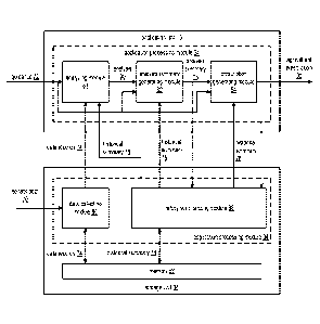
The computing unit 26 includes an application processing module 34, a memory
58,
and one or more internal interfaces to one or more of the user interface
output 50, the user
interface input 52, the sensors 1-S, the interface 54, the wireless
communication modems 1-
M, and the wireless location modem 56. The memory 58 provides a non-transitory
computer
readable storage medium that stores operational instructions that are executed
by the
processing module 34.
The memory 58 may include a single memory device or a plurality of memory
devices. Each memory device is associated with a memory type including one or
more of a
read-only memory, random access memory, volatile memory, non-volatile memory,
cache
memory, and/or any device that stores digital information. Each memory device
may be
implemented utilizing one or more technologies including static random access
memory
(SRAM), dynamic random access memory (DRAM), NAND flash memory, magnetic
memory (e.g., a hard disk), and optical memory (e.g., an optical disc) that
stores digital
information. The memory device may be removable (e.g., a universal serial bus
flash drive)
to facilitate transfer of data between the computing unit 26 and other
entities that may
operably coupled with the removable memory device.
Figure 5 is a schematic block diagram of another embodiment of a computing
system
that includes the wireless location network 18, the wireless communication
network 1, the
network 24, the application unit 16, the storage unit 36, and the user device
14 that is
associated with geographic region 1-1. Within the geographic region 1-1 are
the user device
1-1A (e.g., embedded control electronics of a farming tractor) and the user
device 1-1C (e.g.,
a smart phone utilized by an operator of the farming tractor).
In an example of operation of performing one of the five example functions,
the user
device 1-1A determines location information based on receiving wireless
location signals 38
from the wireless location network 18 and captures sensor data (e.g., farming
tractor
accelerometer data, soil moisture levels, soil chemical content, etc.) along a
drive path 1-1 for
at least a portion of the geographic region 1-1. The drive path 1-1 includes a
geographic path
of the user device 1-1A when the user device 1-1A operates within the
geographic region 1.
The drive path may include two or more sub-drive paths. For example, a first
sub-drive path
traverses the geographic region 1-1 from west to east and a second sub-drive
path traverses
the geographic region 1-1 from east to west. The user device 1-1A may monitor
the drive
path (e.g., passively monitoring along a path taken by the farming tractor) or
may provide the
drive path (e.g., where an agricultural prescription includes control
information to invoke
operation of the farming tractor along the drive path). The
drive path 1-1 may be
14
CA 02945820 2016-10-13
WO 2015/164393 PCT/US2015/026906
obtained by the user device 1-1A in a variety of ways including one or more of
determining a
specific drive path in accordance with the agricultural prescription 80,
utilizing a
predetermined drive path (e.g., the drive path for geographic region 1-1 from
a list),
generating a random drive path, utilizing a previous drive path associated
with geographic
region 1-1 (e.g., obtaining a historical summary), and receiving the
agricultural prescription
80 that includes control information associated with the drive path. As a
specific example,
the user device 1-1A utilizes the drive path 1-1 from the agricultural
prescription 80 while an
associated farming tractor and tilling machinery is tilling the soil of at
least a portion of the
geographic region 1-1.
Having captured the sensor data, the user device 1-1A sends, using, for
example,
Bluetooth wireless communication signals, the captured sensor data to the user
device 1-1C.
The user device I- IC sends, utilizing, for example, long-term evolution (LTE)
wireless
communication signals, the captured sensor data 70 via the wireless
communication network
1 and the network 24 to the storage unit 36. The application processing module
34 of the
storage unit 36 processes the captured sensor data 70 to produce data records
74 for storage in
the memory of the storage unit 36. Alternatively, a removable memory of the
user device 1-
1A is utilized to temporarily store the captured sensor data 70. The removable
memory is
operably coupled to the storage unit 36 to facilitate transfer of the captured
sensor data 70 to
the application processing module 34 of the storage unit 36. For example, the
removable
memory device is directly interfaced to the storage unit 36. As another
example, the removal
memory device is interfaced to the user device 14 associated with the
geographic region 1-1
and the user device 14 facilitates sending, via the network 24, the captured
sensor data 70 to
the storage unit 36.
The application processing module 34 of the user device 14 associated with the
geographic region 1-1 receives a user input to invoke a request for an
analysis and generation
of an agriculture prescription 80. The application processing module 34 of the
user device 14
generates guidance 72 based on the request and other desired characteristics
(e.g., a crop list,
a time frame, equipment availability, chemical availability, and soil
management operational
ranges available) of the agriculture prescription 80 for the geographic region
1-1. The user
device 14 sends, via the network 24, the guidance 72 to the application unit
16. The
application processing module 34 of the application unit 16 obtains the data
records 74 for
the geographic region 1-1 from the storage unit 36 based on the guidance 72.
The application
processing module 34 of the application unit 16 may further obtain historical
summaries 76
with regards to the geographic region 1-1 based on the guidance 72.
CA 02945820 2016-10-13
WO 2015/164393 PCT/US2015/026906
Having obtained the guidance 72, the data records 74, and/or the historical
summaries
76, the application processing module 34 of the application unit 16 produces
an analysis
based on the data records 74 and/or the historical summaries 76. The
application processing
module 34 of the application unit 16 processes the analysis in accordance with
the guidance
72 and/or the historical summaries 76 to produce an analysis summary 78. The
application
processing module 34 of the application unit 16 facilitates storage of the
analysis summary 78
by the storage unit 36 to enable subsequent recovery of the historical
summaries 76 that
includes the analysis summary 78.
Having produced the analysis summary 78, the application processing module 34
of
the application unit 16 processes the analysis summary 78 in accordance with
the guidance 72
and the historical summaries 76 to produce the agricultural prescription 80.
The agricultural
prescription 80 may further include a plurality of steps, where each step
includes one or more
actions, and for each action, one or more required preconditions to execute
the action. Such
steps may be executed in parallel, in series, and in a combination in
accordance with the
preconditions for execution.
The preconditions for execution of the action includes required conditions to
enable
execution of the action (e.g., when to execute the action) including one or
more of a current
date match, a current date within a date range, a time within a time range, a
current data
sensor value within a desired range (i.e., a current temperature within a
temperature range),
an actuator readiness state, distance from a previously executed step (i.e.,
seed dispensing
population of seeds per acre), and elapsed time since a previously executed
step). For
example, a precondition for planting a short growing seed at a later date has
occurred within a
growing season.
Each action includes what to do and how to do it (e.g., when to do it is a
.. precondition). As such, each action includes one or more of dispensing
particular one or
more materials (i.e. a gas, a liquid, a slurry, a solid), how to dispense the
material (i.e.,
distance between dispensing points, distance between parallel dispensing
tracks), collect
sensor data, and manipulate another object (i.e. management practices
including one or more
of: tilling, irrigation control, sunlight control), activate a variant of an
electromagnet field).
.. The liquids include chemical compounds such as fertilizers and pesticides.
The pesticides
include one or more of insecticides (e.g., insect killers), herbicides (e.g.,
weed killers), and
fungicides (e.g., to kill or inhibit fungi). The solids include one or more of
seed, fertilizer
powder, and manure. The seeds include a plurality of hybrid seed types and may
vary from
growing season to growing season.
16
CA 02945820 2016-10-13
WO 2015/164393 PCT/US2015/026906
Having produced the agricultural prescription 80, the application processing
module
34 of the application unit 16 sends, via the network 24, one or more of the
analysis summary
78 and the agricultural prescription 80 to the user device 14. The application
processing
module 34 of the application unit 16 may further send the agricultural
prescription 80, via the
network 24 and the wireless communication network 1, to the user device 1-1C
for utilization
in performing of one or more steps of the agricultural lifecycle in accordance
with the
agricultural prescription 80. For example, the user device 1-1C displays a
portion of the
agricultural prescription 80 and sends control information of the agricultural
prescription, via
wireless signals 42, to the user device 1-1A to automate a portion of the
execution of at least
some of the steps of the agricultural lifecycle. For the example, the user
device 1-1A issues
control information to a set of actuators to dispense fertilizer in accordance
with the
agricultural prescription 80. For instance, to control dispensing a specified
volume of liquid
fertilizer in a specified date range in a specified geometric pattern for at
least a portion of the
geographic region 1-1 as the user device 1-1A versus the drive path 1-1.
Figure 6 is a diagram illustrating an embodiment of a drive path 1-1 for an
associated
geographic region 1-1. In an example of operation, the user device 1-1A of
Figure 1
traverses the drive path 1-1 when executing steps of an agricultural
lifecycle. The traversing
of the drive path 1-1 may be in accordance with an agricultural prescription.
The drive path
1-1 includes a plurality of corresponding drive paths 1-1-1, 1-1-2, 1-1-3, 1-1-
4, etc. Each
corresponding drive path may be associated with a portion of the overall drive
path such that
the corresponding drive path is associated with favorable attributes. Such
favorable attributes
includes one or more of minimizing waste by including fewer turnaround
sections or deleting
sections that link one corresponding drive path to another, minimizing fuel
usa2e, minimizing
soil erosion, maximizing crop yield, and maximizing overall efficiency of
executing one or
more steps of an agricultural lifecycle. For example, drive path 1-1-1 extends
from a western
edge of the geographic region 1-1 to an eastern edge of the geographic region
1-1 such that a
farming tractor traversing the drive path 1-1-1 minimizes an amount of time to
cover acreage
associated with drive path 1-1-1 (e.g., driving in a substantially straight
line).
The user device 1-1A includes an array of sensors that are utilized along the
drive
path 1-1 to capture sensor data in accordance with a data capture scheme. The
agricultural
prescription may include the data capture scheme. The data capture scheme
includes one or
more of where to capture sensor data (e.g., coordinates, distance between
capturing), when to
capture sensor data (e.g., how often, precondition trigger), which sensors to
capture sensor
data from (e.g., selecting particular sensors based on a step of an
agricultural lifecycle), and
17
CA 02945820 2016-10-13
WO 2015/164393 PCT/US2015/026906
how to capture the sensor data (e.g., instantaneous sample, average sample,
another
mathematical distribution applied to sample data).
The user device 1-1A may utilize the array of sensors to capture the sensor
data for as
many as each pass along the drive path 1-1 when operating within the
geographic region 1-1
to execute at least some of the steps of the agricultural lifecycle. For
example, the user
device 1-1A captures sensor data while one or more of the following steps of
the agricultural
lifecycle are executed: initiating a planting cycle by tilling soil, applying
fertilizer, applying
pesticide, planting a primary crop, simultaneously applying fertilizer while
planting the
primary crop, planting a cover crop (e.g., utilized to minimize soil erosion
and enhance soil
nutrients), managing irrigation, harvesting according to a time schedule,
harvesting based on
detecting a crop condition trigger (e.g., crop moisture content), tilling the
soil after
harvesting, and applying fertilizer after harvesting.
The capturing of the sensor data may be unique for each of the corresponding
drive
paths. For example, the data capture scheme indicates to capture the sensor
data from all
sensors along the drive path 1-1-1 every one tenth of an inch to produce data
capture points
1,1, 1,2, 1,3, 1,4, etc. When capturing the sensor data at periodic distance
intervals, one of
the data sensors may be utilized to measure the distance between data capture
points to
trigger capture of a next set of sensor data at a next data capture point. As
another example,
the data capture scheme indicates to capture the sensor data from sensors 1,
3, 5, and 7 along
the drive path 1-1-2 every two seconds. As yet another example, the data
capture scheme
indicates to capture the sensor data from sensors 2 and 4 along the drive path
1-1 when sensor
data from sensor 1 is interpreted to detect that a particular chemical density
level is less than
a low chemical density threshold level.
Figure 7 is a diagram illustrating a relationship between the user device 1-1A
and
tracks 1-7 along the drive path 1-1-1. The user device 1-1A includes the
application
processing module 34, an array of sensors 1-7. sensor L, sensor R, and sensor
ALL to capture
corresponding sensor 70 data along the drive path 1-1-1 as the user device 1-
1A traverses the
drive path 1-1-1 in accordance with a velocity 1-1-1. The velocity 1-1-1 may
be established
as at least one of a random velocity, a predetermined velocity, and an
instantaneous velocity
in accordance with a velocity schedule. An agricultural prescription may
include the velocity
schedule for each corresponding drive path or portion thereof.
The drive path 1-1-1 is associated with the tracks 1-7 and may include further
tracks.
Each track is a virtual path substantially parallel with the drive path 1-1-1.
A center track
(e.g., track 4) may further align with the drive path 1-1-1 and each other
track runs in parallel
18
CA 02945820 2016-10-13
WO 2015/164393 PCT/US2015/026906
to the center track, where each track is separated from another track by a
potentially unique
distance d (e.g., different distances between different tracks in a typical
range of a few
centimeters to many meters). For example, track 3 is separated from track 4 by
distance d3-4
of 8 inches and track 4 is separated from track 5 by distance d4-5 of 20
inches. The
agricultural prescription may include a number of tracks, each of the
distances that separate
the tracks, and a track to sensor mapping.
Each sensor is associated with one or more tracks. For example, sensor 1 is
associated with track 1, sensor 2 is associated with track 2, sensor 3 is
associated with track 3,
etc., through sensor 7 is associated with track 7; sensor L is associated with
tracks 1-4; sensor
R is associated with tracks 4-7; and sensor ALL is associated with tracks 1-7.
Each sensor
may include capabilities to sense one or more attributes associated with one
or more of the
tracks in accordance with the track mapping. For example, sensors 1-7 include
image sensors
to detect and enable identification of objects (e.g., desired and undesired)
along tracks 1-7,
sensor L includes an ultrasonic sensor to detect objects associated with
tracks 1-4, sensor R
includes an ultrasonic sensor to detect objects associated with tracks 4-7,
and sensor ALL
includes an accelerometer to provide inertia information with regards to a
farming tractor
associated with the user device 1-1A (e.g., to enable precision location
determination).
The application processing module 34 captures the sensor data 70 from the
array of
sensors from time to time in accordance with a data capture scheme. The
application
processing module 34 processes the sensor data 70 in accordance with a sensor
data
processing scheme. The agricultural prescription may include the sensor data
processing
scheme. The application processing module 34 obtains the sensor data
processing scheme by
at least one of accessing a predetermination, initiating a query, receiving a
query response,
receiving the agricultural prescription, and determining the agricultural
prescription.
The sensor data processing scheme includes one or more of locally storing at
least a
portion of the sensor data, outputting at least some of the sensor data,
identifying a portion of
the sensor data for analysis, analyzing the identified portion of the sensor
data to produce an
analysis, summarizing the analysis to produce an analysis summary, and
generating an
updated agricultural prescription. As a specific example of capturing the
sensor data 70, the
application processing module 34 captures the sensor data 70 from the array of
sensors at a
data capture point 1,1 for each of the tracks 1-7, where the distance between
tracks is 8
inches; captures the sensor data 70 from the array of sensors at a data
capture point 1, 2 for
each of the tracks 1-7, where the distance between tracks is adjusted to 6
inches, from sensor
L, from sensor R, and from sensor ALL; captures the sensor data 70 from the
array of sensors
19
CA 02945820 2016-10-13
WO 2015/164393 PCT/US2015/026906
at a data capture point 1, 3 for each of the tracks 1-7, where the distance
between tracks is
maintained at 6 inches, and the velocity 1-1-1 is suggested from 8 miles per
hour (MPH) to
11 MPH; etc.
Figure 8 is a diagram illustrating an example of a structure of a geographic
region 1-1
-- data record, where the data records 74 may include the geographic region 1-
1 data record.
The geographic region 1 -1 data record includes a plurality of drive path data
records 1-1-1,
1-1-2, 1-1-3, etc. Each drive path data record is associated with a plurality
of corresponding
drive paths of a drive path associated with the geographic region 1-1. Each
drive path data
record includes data capture point data records. For example, the drive path 1-
1-1 data record
-- includes data capture point data records for data capture points 1,1, 1,2,
1,3, 1,4. etc.
Each data capture data record includes the sensor data 70 for a sensor array
corresponding to a user device associated with capture of the sensor data. For
example, the
data capture point data records for the drive path 1-1-1 data record includes
sensor data 1-8,
sensor data L, sensor data R, sensor data ALL, and may include further data
associated with
-- data capture point 1,1. The further data may include one or more of a
timestamp
corresponding to capturing of the sensor data, a timestamp corresponding to
receiving of the
captured sensor data, location information associated with the data capture
point, an identifier
of a user device associated with the sensor array, identifiers for each sensor
of the sensor
array, an identifier associated with another user device that is associated
with the user device,
-- an identifier of the geographic region, an identifier of the drive path
data record, an identifier
of the data capture point, a data owner identifier, an access control list,
security credentials,
security information (e.g., a signed certificate. an encryption key, an
encryption key seed),
and any other data to facilitate optimization of an agricultural lifecycle.
Figure 9 is a schematic block diagram of an embodiment of the application unit
16
-- and of the storage unit 36, where the application unit 16 and the storage
unit 36 include
corresponding application processing modules 34 and may include the memory 58.
Alternatively, a single computing device may include each application
processing module 34
and each memory 58. The application processing module 34 of the application
unit 16
includes an analyzing module 81, an analysis summary generating module 82, and
a
-- prescription generating module 84. The application processing module 34 of
the storage unit
36 includes a data collecting module 86 and a history summarizing module 88.
The application unit 16 and storage unit 36 perform at least some steps
associated
with the five example functions of the computing system 10. In an example of
operation, the
data collecting module 86 receives sensor data 70 from one or more user
devices associated
CA 02945820 2016-10-13
WO 2015/164393 PCT/US2015/026906
with a geographic region of a plurality of geographic regions. The data
collecting module 86
generates one or more data records 74 based on the sensor data 70 and stores
the one or more
data records 74 in the memory 58 of the storage unit 36.
The analyzing module 81 receives guidance 72 from a user device (e.g., the
user
device 14 of Figure 1) associated with the geographic region. For example, the
guidance 72
includes a request for an analysis and conditions of the analysis. The
analyzing module 81
obtains data records 74 from the data collecting module 86 based on the
guidance 72 and may
further obtain a historical summary 76 from the history summarizing module 88
based on the
guidance 72. Hereafter, the historical summary 76 may be interchangeably
referred to as a
history summary. For example, the analyzing module 81 issues a data records
request to the
data collecting module 86 with regards to the geographic region and receives
the data records
74 from the data collecting module 86, where the received data records 74 are
associated with
the geographic region and adjacent geographic regions to the geographic
region. As another
example, the analyzing module 81 issues a history summary request to the
history
summarizing module 88 and receives the historical summary 76 with regards to
the
geographic region and the adjacent geographic regions from the history
summarizing module
88.
Having obtained the data records 74 and the historical summary 76, analyzing
module
81 analyzes one or more of the data records 74 and the historical summary 76
to produce an
analysis 90 in accordance with the guidance 72. For example, the analyzing
module 81
identifies results from the data records 74 and correlates the results to
specific steps of an
agricultural lifecycle of the historical summary 76 to produce the analysis
90, where the
analysis 90 indicates results and associated steps.
The analysis summary generating module 82 obtains another historical summary
76
from the history summarizing module 88, where the other historical summary 76
includes a
previous analysis summary associated with the geographic region. Having
received the
historical summary 76, the analysis summary generating module 82 summarizes
the analysis
90 in accordance with one or more of the guidance 72 and the historical
summary 76 to
produce an analysis summary 78. For example, the analysis summary generating
module 82
determines probabilities of favorable results associated with the steps based
on previous sets
of results and steps.
The history summarizing module 88 may obtain the analysis summary 78 and
process
the analysis summary 78 to produce a further historical summary 76 for storage
in the
memory 58 of the storage unit 36. The prescription generating module 84
obtains yet another
21
CA 02945820 2016-10-13
WO 2015/164393 PCT/US2015/026906
historical summary 76 from the history summarizing module 88, where the yet
another
historical summary 76 may include one or more previous agricultural
prescriptions associated
with the geographic region and/or agricultural prescriptions associated with
the adjacent
geographic regions. Having received the analysis summary 78 and the yet
another historical
summary 76, the prescription generating module 84 generates a prescription 80
for the
geographic region based on one or more of the analysis summary 78, the yet
another history
summary 76, and the guidance 72. For example, the prescription generating
module 84
utilizes the probabilities of favorable results associated with the steps to
recommend steps of
the agricultural lifecycle associated with the geographic region and in
accordance with the
guidance 72 (e.g., for a specific desired crop type).
The prescription 80 may include one or more of steps, actions associated with
each
step, and preconditions for each action. The prescription generating module 84
outputs the
prescription 80 which may include sending the prescription 80 to the history
summarizing
module 88. When receiving the prescription 80, the history summarizing module
88
processes the prescription 80 to produce an updated historical summary 76 for
storage in the
memory 58.
Figure 10 is a diagram illustrating another embodiment of the drive path 1-1
for
associated geographic region 1-1. The user device 1-1A captures sensor data at
the plurality
of data capture points along each associated drive path of the drive path 1-1
and provides
action data along at least some of the associated drive paths. The user device
enables
execution of the action data along each associated drive path in accordance
with an
agricultural prescription.
The action data includes one or more steps of an agricultural lifecycle, and
may
further include actions and associated preconditions for each action. For
example, an action
may include depositing a specified volume of liquid fertilizer along the drive
path 1-1-1 at
specific intervals. As another example, the action may include planting seeds
of a desired
crop at a specific soil depth at specified intervals along the drive path 1-1-
2. For instance, a
specified average number of seeds are deposited along the drive path 1-1-2 in
accordance
with action data 2, 4 followed by depositing further seeds along the drive
path 1-1-2 in
accordance with action data 2, 3 etc.
Figure 11 is a diagram illustrating a relationship between the user device 1-
1A, an
actuator set 92, and the tracks 1-7 along the drive path 1-1-1. In an
embodiment, the actuator
set 92 includes a set of actuators 1-7, actuator L, actuator R, and actuator
ALL. Each actuator
is operable to perform an action in accordance with control information 94
including one or
22
CA 02945820 2016-10-13
WO 2015/164393 PCT/US2015/026906
more of dispensing fluid (e.g., fertilizer, pesticide, fungicide), dispensing
a solid (e.g.,
planting a seed), and manipulating soil (e.g., tilling). An agricultural
prescription 80 includes
the control information 94 that includes the actions of the planting. The user
device 1-1A
includes the sensor array of Figure 7 and the application processing module 34
of Figure 7.
The control information 94 further includes one or more instructions with
regards to
implementation of actions performed by the actuators. The instructions
includes one or more
of setting a distance d between the tracks, planting a seed at a specified
planting depth,
dispensing a specified volume of a liquid within a linear distance along a
track, setting a
velocity 1-1-1 of traversing of the drive path 1-1-1 in accordance with a
velocity schedule,
modifying the velocity 1-1-1 based on real-time sensor data, and utilizing one
or more
sensors to detect preconditions to enable execution of one or more actions.
The user device 1-1A and the actuator set 92 share a common implementation
association. For example, embedded control electronics of a farming tractor
includes the user
device 1-1A and a farming planting mechanism, propelled by the farming
tractor, includes
the actuator set 92, where the actuator set 92 facilitates actions associated
with planting along
the drive path 1-1-1.
Each actuator may be associated with one or more of the tracks 1-7. For
example,
actuator 1 is associated with track 1, actuator 2 is associated with track 2,
etc., through
actuator 7 is associated with track 7, actuator L is associated with tracks 1-
4, actuator R is
associated with tracks 4-7, and actuator ALL is associated with tracks 1-7.
For example,
actuators 1-7 include planting actuators. actuator L includes a mechanism to
simultaneously
adjust a position of actuators 1-4 (e.g., lift left, lower left). actuator R
includes a mechanism
to simultaneously adjust a position of actuators 4-7 (e.g., lift right, lower
right), and actuator
ALL includes a mechanism to simultaneously adjust a position of actuators 1-7
(e.2., lift all,
lower all).
In an example of operation, the application processing module 34 of the user
device
l -1A extracts the control information 94 from the received prescription 80
and activates the
actuator set 92 with the control information 94. As the user device 1-1A and
the actuator set
92 traverses the drive path 1-1-1 at velocity 1-1-1, the actuator set 92
performs the actions of
the control information 94 (e.g., plants seeds along the tracks) in accordance
with a plurality
of action data 1,1. 1,2, 1,3, 1,4, etc., and the application processing module
34 captures
sensor data 70 from the array of sensors at data capture points 1,1, 1,2, 1,3,
1,4, etc. The
application processing module 34 may update the control information 94 based
on the
captured sensor data 70. For example, the application processing module
modifies a planting
23
CA 02945820 2016-10-13
WO 2015/164393 PCT/US2015/026906
depth of the control information 94 based on a moisture sensor data value and
in accordance
with the prescription 80.
Figures 12A and 12B are a schematic block diagram of an embodiment of a
computing system 100 that includes the wireless location network 18 of Figure
1, the
geographic region 1-1 of Figure 3, the wireless communication network 1 of
Figure 1, the
network 24 of Figure 1, the user device 14 of Figure 1, and the application
unit 16 of Figure
1. The geographic region 1-1 includes the user devices 1-1A and 1-1C of Figure
1, where the
user device 1-1A is associated with agriculture equipment (e.g., operably
coupled to a
farming tractor of a plurality of farming tractors) and traverses a drive path
1-1 (e.g., with at
least one of the agriculture equipment) within the geographic region 1-1.
Hereafter, the user
devices 1-1A and 1-1C may be interchangeably referred to as the agriculture
equipment and
the geographic region may be interchangeably referred to as an agriculture
region. The user
device 14 includes the application processing module 34 of Figure 4. The
application unit 16
includes the application processing module 34 of Figure 4 and the memory 58 of
Figure 4.
Hereafter, the application unit 16 may be interchangeably referred to as a
host device. The
computing system functions to generate an agriculture prescription. The
generation of the
agriculture prescription is discussed in greater detail with reference to
Figures 12A-12H.
Figure 12A illustrates steps of an example of operation of the generating of
the
agriculture prescription where the agriculture equipment collects current on-
site gathered
.. agriculture data regarding an agriculture region (e.g., geographic region 1-
1). For example,
the user device 1-1A collects sensor data (e.g., accelerometer data) with
regards to the
geographic region 1-1 as the associated agriculture equipment traverses the
drive path 1-1;
sends, via wireless communication signals 42, the sensor data to the user
device 1-1C; and
the user device 1-1C receives wireless location signals 38 from the wireless
location network
18 to produce location information associated with the sensor data.
The collecting of the current on-site gathered agriculture data may further
include at
least one collecting approach of a variety of collecting approaches. As a
specific example of
a first collecting approach, the user device 1-1A receives, via the network 24
and the wireless
communication network 1 by way of the wireless communication signals 42, from
the host
device (e.g., the application unit 16), an indication to collect the current
on-site gathered
agriculture data. For instance, the user device 1-1A receives a collect-all
sensor data
indicator from the host device the indication to collect the current on-site
gathered agriculture
data.
24
CA 02945820 2016-10-13
WO 2015/164393 PCT/US2015/026906
As a specific example of a second collecting approach, the user device 1-1A
receives,
from the host device, a message to collect a particular type of agriculture
data. For instance,
the user device 1-1A receives an indicator to collect the accelerometer data
as the message to
collect the particular type of agriculture data. As a specific example of a
third collecting
approach, the user device 1-1A interprets an agriculture prescription to
determine one or
more types of agriculture data to collect as the current on-site gathered
agriculture data. For
instance, the user device 1-1A receives an agriculture prescription that
includes an indicator
to collect the accelerometer data and interprets the received agriculture
prescription to
determine to collect the accelerometer data as the current on-site gathered
agriculture data.
Having collected the current on-site gathered agriculture data regarding the
agriculture region, the user device 1-1A sends, at least a representation of
the current on-site
gathered agriculture data to the host device (e.g., the application unit 16).
For example, the
user device 1-1A and the user device 1-1C produces agriculture data for region
1-1 as the
representation and sends, via the wireless location signals 42, the
agriculture data for region
1-1 to the wireless location network 1, where the wireless communication
network 1 sends,
via the network 24 the agriculture data for region 1-1 to the application unit
16.
The sending may further include at least one of a variety of sending
approaches. As a
specific example of a first sending approach, the user device 1-1A generates
the at least a
representation of the current on-site gathered agriculture data by utilizing
the current on-site
gathered agriculture data as the at least a representation of the current on-
site gathered
agriculture data. For instance, the user device 1-1A utilizes the sensor data
as the
representation (e.g., raw sensor data). As a specific example of a second
sending approach,
the user device 1-1A filters, based on the agriculture prescription, the
current on-site gathered
agriculture data to produce the at least a representation of the current on-
site gathered
agriculture data. For instance, the user device 1-1A selects every tenth
accelerometer data
sample along the drive path 1-1 to filter the accelerometer data to produce
the representation.
As a specific example of a third sending approach, the user device 1-1A and/or
the
user device 1-1C compile the current on-site gathered agriculture data to
produce the at least
a representation of the current on-site gathered agriculture data. For
instance, the user device
1-1A sends the accelerometer data, via wireless communication signals 42
(e.g., Bluetooth) to
the user device 1-1C and the user device 1-1C associates the accelerometer
data with the
location information to produce the representation. As a specific example of a
fourth sending
approach, user device 1-1A processes the current on-site gathered agriculture
data to produce
the at least a representation of the current on-site gathered agriculture
data. For instance, the
CA 02945820 2016-10-13
WO 2015/164393 PCT/US2015/026906
user device 1-1A performs an averaging function on the accelerometer data
(e.g., to produce
an average elevation for a portion of the drive path 1-1) to produce the
representation.
Alternatively, or in addition to, still further user devices associated with
the
geographic region 1-1 send corresponding representations of the current on-
site gathered
agriculture data associated with the geographic region 1-1. Further
alternatively, or further in
addition to, the user device 1-1A and/or the user device 1-1C send further
representations of
further current on-site gathered agriculture data associated with the
geographic region 1-1
when the user device 1-1A further traverses the drive path 1-1 (e.g., for each
pass of the
farming tractor performing steps of an agriculture lifecycle along the drive
path 1-1).
Figure 12B illustrates further steps of the example of operation of the
generating of
the agriculture prescription 114 where the host device processes one or more
of the at least a
representation of the current on-site gathered agriculture data, current off-
site gathered
agriculture data 110, historical on-site gathered agriculture data, historical
off-site gathered
agriculture data, and historical analysis of agriculture predictions regarding
the agriculture
region to produce a current agriculture prediction for the agriculture region.
For example, the
application processing module 34 of the application unit 16 compares the
current on-site
gathered agriculture data with the historical on-site gathered agriculture
data (e.g., from a
previous traversing of the geographic region) to produce a topographical trend
(e.g., detecting
a change in elevation of a portion of the geographic region that is greater
than a change in
elevation threshold level) as the current agriculture prediction.
The processing may further include the host device receiving the at least a
representation of the current on-site gathered agriculture data and storing
the received
representation. For instance the application processing module 34 of the
application unit 16
receives, via the network 24 and the wireless communication network 1, the
agriculture data
for region 1-1 and stores the agriculture data for region 1-1 in the memory 58
producing a
new portion of the historical on-site gathered agriculture data.
The processing may further include the application unit 16 receiving, via the
network
24, the current off-site gathered agriculture data 110 from an external entity
(e.g., a server via
a public Internet, a server of a private computing system, a fixed sensor
array, etc.), where the
current off-site gathered agriculture data 110 includes one or more of current
regional
topology information (e.g., a current topographical map of the geographic
region), current
weather data (e.g., temperature, wind direction, wind speed, precipitation
level, sunlight
intensity, etc.), and current soil conditions (e.g., moisture level, nutrient
level, fertilizer level,
etc.).
26
CA 02945820 2016-10-13
WO 2015/164393 PCT/US2015/026906
The processing may further include the application unit 16 retrieving, from
the
memory 58, one or more of the historical on-site gathered agriculture data,
the historical off-
site gathered agriculture data, the historical analysis of the agriculture
predictions, where the
historical off-site gathered agriculture data includes one or more of
historical regional
topology information (e.g., a series of chronologically ordered topographical
maps of the
geographic region), historical weather data (e.g., historical temperatures,
historical wind
directions, historical wind speeds, historical precipitation levels,
historical sunlight
intensities, etc.), and current historical soil conditions (e.g., historical
moisture levels,
historical nutrient levels, historical fertilizer levels, etc.).
The processing by the host device may further include, for a given snapshot of
an
agriculture season (e.g., for a time portion of the agriculture lifecycle),
comparing agriculture
predictions with actual agriculture results to produce comparison data. For
example, the
application processing module 34 of the application unit 16 analyzes
agriculture data for the
agriculture region 1-1 associated with a harvesting portion of the agriculture
season to
produce the actual agriculture results (e.g., yield in terms of bushels of
corn per acre), and
compares an agriculture prediction associated with an earlier portion of the
agriculture season
with the actual agriculture results associated with the harvesting portion to
produce the
comparison data (e.g., indicating accuracy of the agriculture prediction for
the harvesting of
the corn).
Having produced the comparison data, the host device processes the comparison
data
with the one or more of the at least a representation of the current on-site
gathered agriculture
data, the current off-site gathered agriculture data, the historical on-site
gathered agriculture
data, the historical off-site gathered agriculture data, and the historical
analysis of agriculture
predictions regarding the agriculture region to produce an in-season course
correction
agriculture prediction for the agriculture region. For example, the
application processing
module 34 of the application unit 16 processes the indicated accuracy of the
comparison data
for the harvesting of the corn and the historical analysis of agriculture
predictions (e.g., from
previous agriculture lifecycles of the agriculture region 1-1) to produce the
in-season course
correction agriculture prediction for the agriculture region 1-1. For
instance, the application
processing module 34 generates the in-season course correction agriculture
prediction that
indicates optimizing of crop yield further includes a requirement to use 4%
more fertilizer
than a previous agriculture prediction.
The processing by the host device may further include processing geographical
information of the at least a representation of the current on-site gathered
agriculture data to
27
CA 02945820 2016-10-13
WO 2015/164393 PCT/US2015/026906
produce a current topographical map of the agriculture region. For example,
the application
processing module 34 processes the accelerometer data and corresponding
location
information of the agriculture data for region 1-1 for multiple passes of the
drive path 1-1 to
produce the current topographical map of the agriculture region 1-1. Having
produced the
current topographical map. the host device compares the current topographical
map with one
or more previous topographical maps of the agriculture region to detect one or
more areas of
erosion. For example, the application processing module 34 of the application
unit 16 detects
a pocket area of a lowering of an elevation level over time and indicates the
pocket area as
the area of erosion. The generating of the current topographical map and the
detecting of the
erosion is discussed in greater detail with reference to Figures 12D-H.
Having produced one or more of the current agriculture prediction and the in-
season
course correction agriculture prediction, the host device generates an
agriculture prescription
114 regarding at least a portion of the agriculture region based on one or
more of the current
agriculture prediction and the in-season course correction agriculture
prediction. For
example, the application processing module 34 of the application unit 16
analyzes a series of
current agriculture predictions with regards to correlation of steps of the
agriculture lifecycle
and crop yield optimization and selects a group of steps to produce the
agriculture
prescription 114, where the selected group of steps facilitates the crop yield
optimization.
The host device may produce the agriculture prescription 114 in accordance
with a
variety of producing approaches. As an example of a first producing approach,
the host
device establishes a speed pattern (e.g., average velocity, maximum velocity,
minimum
velocity, etc.) for one of the agriculture equipment while traversing the at
least a portion of
the agriculture region. For example, the application processing module 34 of
the application
unit 16 identifies an optimal speed (e.g., not too slow, not too fast) for the
farming tractor of
the agriculture equipment when performing one or more steps of the agriculture
prescription
for each of a plurality of portions of the agriculture region, where the
optimal speeds correlate
to the improved crop yield optimization. The identifying of the optimal speed
is discussed in
greater detail with reference to Figures 16A-C.
As an example of a second producing approach, the host device establishes a
crop
.. planting orientation pattern for the one of the agriculture equipment while
traversing the at
least a portion of the agriculture region. For example, the application
processing module 34
of the application unit 16 identifies an optimal direction (e.g., heading) for
the farming tractor
of the agriculture equipment when performing the one or more steps of the
agriculture
prescription for the each of a plurality of portions of the agriculture
region, where the optimal
28
CA 02945820 2016-10-13
WO 2015/164393 PCT/US2015/026906
directions correlate to the improved crop yield optimization. The identifying
of the optimal
direction is discussed in greater detail with reference to Figures 14A-C.
As an example of a third producing approach, a host device establishes a crop
planting distribution pattern for the one of the agriculture equipment while
traversing the at
least a portion of the agriculture region. For example, the application
processing module 34
of the application unit 16 identifies an optimal crop planting distribution
pattern (e.g., seed
depth, seed spacing, etc.) for the farming tractor of the agriculture
equipment when
performing the one or more steps of the agriculture prescription for the each
of a plurality of
portions of the agriculture region, where the optimal crop planting
distribution patterns
correlate to the improved crop yield utilization.
Having produced the agriculture prescription 114, the host device sends the
agriculture prescription 114 to one or more of the agriculture equipment.
Alternatively, or in
addition to, the host device sends the agriculture prescription 114 to the
user device 14, where
the user device 14 may further process and/or display the agriculture
prescription 114. For
example, the application processing module 34 of the application unit 16
sends, via the
network 24, the agriculture prescription 114 to the user device 14 and to the
wireless
communication network 1. Having received the agriculture prescription 114,
the
communication network 1 sends, via the wireless communication signals 42, the
agriculture
prescription 114 to the user device 1-1C. Having received the agriculture
prescription 114,
the user device 1-1C may further process the agriculture prescription 114
and/or forward, via
further wireless communication signals 42, the agriculture prescription 114 to
the user device
1-1A. The processing of the agriculture prescription 114 by the user device 1-
1C may
include one or more of extracting an indicator to collect agriculture data,
identifying steps of
the agriculture prescription associated with the user device 1-1C, and
modifying the
agriculture prescription 114 to produce an updated agriculture prescription
114 based on
further collected agriculture data.
Having received the agricultural prescription, the one or more of the
agriculture
equipment executes at least a portion of the agriculture prescription 114. For
example, the
user device 1-1A identifies steps of the agriculture prescription 114
associated with the user
device 1-1A and facilitates execution of the identified steps (e.g., gathering
further
agriculture data, activating actuators associated with the agriculture
equipment, etc.).
Figure 12C is a flowchart illustrating an example of generating the
agriculture
prescription. In particular, a method is presented for use in conjunction with
one or more
functions and features described in conjunction with FIGs. 1-11. 12A-B, and
also FIG. 12C.
29
CA 02945820 2016-10-13
WO 2015/164393 PCT/US2015/026906
The method begins or continues at step 120 where a processing module of one or
more
processing modules of one or more computing devices affiliated with
agriculture equipment
collects current on-site gathered agriculture data regarding an agriculture
region. For
example, a processing module of the agriculture equipment collects the current
on-site
gathered agriculture data regarding an agriculture region. The collecting the
current on-site
gathered agriculture data may further include at least one of the agriculture
equipment
receiving, from a host device, an indication to collect the current on-site
gathered agriculture
data; the agriculture equipment receiving, from the host device, a message to
collect a
particular type of agriculture data; and the agriculture equipment
interpreting an agriculture
prescription to determine one or more types of agriculture data to collect as
the current on-
site gathered agriculture data.
The method continues at step 122 where the agriculture equipment sends at
least a
representation of the current on-site gathered agriculture data to the host
device. The sending
may include one of the agriculture equipment generating the at least a
representation of the
current on-site gathered agriculture data by at least one of utilizing the
current on-site
gathered agriculture data as the at least a representation of the current on-
site gathered
agriculture data, filtering, based on the agriculture prescription, the
current on-site gathered
agriculture data to produce the at least a representation of the current on-
site gathered
agriculture data, compiling the current on-site gathered agriculture data to
produce the at least
a representation of the current on-site gathered agriculture data, and
processing the current
on-site gathered agriculture data to produce the at least a representation of
the current on-site
gathered agriculture data.
The method continues at step 124 where the host device processes one or more
of the
at least a representation of the current on-site gathered agriculture data,
current off-site
gathered agriculture data, historical on-site gathered agriculture data,
historical off-site
gathered agriculture data, and historical analysis of agriculture predictions
regarding the
agriculture region to produce a current agriculture prediction for the
agriculture region. The
method continues at step 126 where the host device, for a given snapshot of an
agriculture
season, compares agriculture predictions with actual agriculture results to
produce
comparison data.
The method continues at step 128 where the host device processes the
comparison
data with the one or more of the at least a representation of the current on-
site gathered
agriculture data, the current off-site gathered agriculture data, the
historical on-site gathered
agriculture data, the historical off-site gathered agriculture data, and the
historical analysis of
CA 02945820 2016-10-13
WO 2015/164393 PCT/US2015/026906
agriculture predictions regarding the agriculture region to produce an in-
season course
correction agriculture prediction for the agriculture region. The method
continues at step 130
where the host device processes geographical information of the at least a
representation of
the current on-site gathered agriculture data to produce a current
topographical map of the
agriculture region when the current topographical map is desired to facilitate
another step.
The method continues at step 132 where the host device compares the current
topographical
map with one or more previous topographical maps of the agriculture region to
detect one or
more areas of erosion.
The method continues at step 134 where the host device generates an
agriculture
prescription regarding at least a portion of the agriculture region based on
one or more of the
current agriculture prediction and the in-season course correction agriculture
prediction. The
host device may generate the agriculture prescription in accordance with a
variety of
generation approaches. The generating step method continues at step 134a where
the host
device establishes a speed pattern for one of the agriculture equipment while
traversing the at
least a portion of the agriculture region when the agriculture prescription
requires the speed
pattern. Alternatively, or in addition to, the generating step method
continues at step 134b
where the host device establishes a crop planting orientation pattern for the
one of the
agriculture equipment while traversing the at least a portion of the
agriculture region when
the agriculture prescription requires the crop planting orientation pattern.
Further
alternatively, or in addition to, the generating step method continues at step
134c where the
host device establishes a crop planting distribution pattern for the one of
the agriculture
equipment while traversing the at least a portion of the agriculture region
when the
agriculture prescription requires the crop planting distribution pattern.
The method continues at step 136 where the host device sends the agriculture
prescription to one or more of the agriculture equipment. For example, the
host device
transmits the agriculture prescription to a fleet of farming tractors. The
sending may further
include transmitting the agriculture prescription to one or more user devices
associated with
the geographic region. The method continues at step 138 where the one or more
of the
agriculture equipment executes at least a portion of the agriculture
prescription. For example,
the fleet of farming tractors executes steps of the agriculture prescription.
The method described above in conjunction with the processing module can
alternatively be performed by other modules of the one or more computing
devices affiliated
with the agriculture equipment or by other devices. In addition, at least one
memory section
(e.g., a non-transitory computer readable storage medium) that stores
operational instructions
31
CA 02945820 2016-10-13
WO 2015/164393 PCT/US2015/026906
can, when executed by one or more processing modules of the one or more
computing
devices affiliated with the agriculture equipment, cause the one or more
computing devices to
perform any or all of the method steps described above.
Figure 12D is a schematic block diagram of another embodiment of a computing
system that includes the wireless location network 18 of Figure 1, the
geographic region 1-1
of Figure 1, the wireless communication network 1 of Figure 1, the network 24
of Figure 1,
the user device 14 of Figure 1, the application unit 16 of Figure 1, and the
storage unit 36 of
Figure 1. The geographic region 1-1 includes the user devices 1-1A and 1-1C of
Figure 1,
where the user device 1-1A traverses the drive path 1-1. User device 14
includes the
application processing module 34 of Figure 3. The application unit 16 includes
the
application processing module 34 of Figure 4. The storage unit 36 includes the
application
processing module 34 of Figure 4 and the memory 58 of Figure 4.
The computing system is operable to identify a sub-region within the
geographic
region 1-1 associated with a results abnormality of an agricultural lifecycle.
The results
.. abnormality may include one or more of a crop yield below a low crop yield
threshold level,
the crop yield above a high crop yield threshold level, utilization of a
resource above a high
resource utilization threshold level, utilization of the resource below a low
resource
utilization threshold level, and any other results metric that compares
unfavorably to an
expected results range. For example, the system identifies a quarter acre
portion of the
geographic region 1-1 that is associated with a corn crop yield rate that is
30% below an
average corn crop yield rate for the entire geographic region 1-1.
The computing system may further operate to identify a potential root cause
for the
results abnormality for the sub-region. For example, the computing system
identifies an
above average level of soil erosion associated with the sub-region as the
potential root cause
for the below average corn crop yield rate. As another example, the computing
system
identifies an above average level of soil buildup associated with the sub-
region has potential
root cause for the below average corn crop yield rate.
In an example of operation, the user device 1-1A obtains a plurality of sets
of sensor
data for two or more instances of operation along the drive path 1-1. The user
device 1-1A
sends, via the wireless communication signals 42 via user device 1-1C, the
wireless
communication network 1, and the network 24, sensor data sets for region 1-1
to the storage
unit 36. The storage unit 36 processes the sensor data sets for region 1-1 to
produce two or
more data records 1, 2. For example, the application processing module 34 of
the storage
unit 36 produces 10 data records that corresponds to a last 10 passes over the
drive path 1-1
32
CA 02945820 2016-10-13
WO 2015/164393 PCT/US2015/026906
by the user device 1-1A. The application processing module 34 of the storage
unit 36 stores
the data records 1, 2 in the memory 58 of the storage unit 36.
The application processing module 34 of the user device 14 issues, via the
network
24, an erosion analysis request 160 to the application unit 16, where the
erosion analysis
request 160 includes an identifier for the geographic region 1-1. The
application processing
module 34 of the application unit 16 obtains, via the network 24, the data
records 1, 2 from
the storage unit 36 based on the erosion analysis request 160, where the data
records 1, 2
pertain to the geographic region 1-1 of the erosion analysis request 160.
Having obtained the data records 1, 2, the application processing module 34 of
the
application unit 16 analyzes the data records 1, 2 in accordance with the
erosion analysis
request 160 to generate a topographic map for each data record with regards to
the
geographic region 1-1. The generating includes the application processing
module 34
analyzing one or more of accelerometer sensor data and location information to
produce an
interim map that includes precise elevation information for a plurality of X Y
coordinates.
For example, application processing module 34 produces the elevation
information for each
data capture point of the drive path 1-1 based on one or more of the
accelerometer sensor data
and the location information. Having produced the interim map, the application
processing
module 34 generates connectors between points of substantially similar
elevation, where
additional points of elevation may be interpolated between the data capture
points. Having
generated the connectors, the application processing module 34 aggregates the
interim map
and the connectors to produce a corresponding topographic map that includes
contour lines of
common elevation levels.
Having produced the topographic map for each data record, the application
processing
34 module of the application unit 16 interprets the contour lines of each
topographic map for
the two or more data records to identify an elevation abnormality trend. The
application
processing module 34 identifies the elevation abnormality trend when a
difference between
elevation levels depicted by contour lines of at least two topographic maps
for a common
location is greater than a difference threshold level. For example, the
application processing
module indicates a soil erosion elevation abnormality trend when an elevation
level depicted
by a first typographic map for a particular location is 6 inches higher than
an elevation level
depicted by a second topographic map for the same particular location, where
the second
topographic map is associated with a later timestamp. As another example, the
application
processing module 34 indicates a soil buildup elevation abnormality trend when
the elevation
level depicted by the first typographic map for the particular location is 6
inches lower than
33
CA 02945820 2016-10-13
WO 2015/164393 PCT/US2015/026906
the elevation level depicted by the second topographic map for the same
particular location,
where the second topographic map is associated with a later timestamp.
Having identified the elevation abnormality trend, the application processing
module
34 of the application unit 16 obtains a historical summary 162 with regards to
the geographic
-- region 1-1 from the storage unit 36, where the historical summary 162
includes historical
crop yield rates for the geographic region 1-1. Having obtained the historical
summary 162,
the application processing module 34 correlates crop yield rates of the
historical summary
162 to the particular location of the elevation abnormality trend to determine
a level of
impact on the crop yield rates as a potential result of the elevation
abnormality trend. Having
-- determined the level of impact, the application processing module 34
generates an erosion
analysis summary 164 that includes one or more of an identifier for the
particular location,
one or more of the topographic maps, one or more of the crop yield rates, and
the level of
impact on the crop yield rates. For example, the application processing module
34 generates
the erosion analysis summary 164 to indicate that crop yield rates associated
with particular
-- location is 30% below the average crop yield rate level of the geographic
region 1-1 since the
erosion has extended beyond an 8 inch level of erosion over the last three
years.
Having generated the erosion analysis summary 164, the application processing
module 34 of the application unit 16 sends, via the network 24, the erosion
analysis summary
164 to one or more of the user device 14 and the storage unit 36.
Alternatively, or in addition
-- to, the application processing module 34 of the application unit 16
generates an agricultural
prescription that includes additional soil management steps (e.g., aggressive
tilling, etc.) of an
agricultural lifecycle to abate the soil erosion.
Figure 12E is a diagram illustrating another embodiment of a drive path for an
associated geographic region 1-1. A user device obtains a plurality of sets of
sensor data for
-- two or more instances of operation along the drive path 1-1 in accordance
with a data capture
scheme. For example, the user device captures a set of sensor data from an
array of sensors
every one tenth of an inch of travel along the drive path 1-1 when the data
capture scheme
indicates to capture sensor data every one tenth of an inch. As such, the user
device captures
sensor data at approximately 633,000 data capture points along each west-to-
east traversal of
the geographic region 1-1 when the traversal is approximately 1 mile in
distance.
The sensor array may cover a 40 foot path along the drive path when a farming
mechanism that includes the sensor array is at least 40 feet in width. As
such, the drive path
further includes approximately 100 horizontal traversals of drive path
elements when the area
34
CA 02945820 2016-10-13
WO 2015/164393 PCT/US2015/026906
of coverage on the drive path is 40 feet and the north to south distance is
approximately 4,000
feet.
The user device produces approximately 63.3 million sets of sensor data when
each of
the 100 horizontal elements of drive path includes the 633,000 data capture
points. Each set
-- of the sensor data include sensor data from sensors spaced apart across the
width of the drive
path. For example, data capture points are spaced one tenth of an inch apart
along a track
where tracks are separated by approximately 6 feet when the drive path with is
approximately
40 feet and seven tracks of sensors are utilized along the drive path.
Figures 12F-G are diagrams illustrating examples of topographic maps for an
-- associated geographic region 1-1. Each topographic map indicates contours
of elevation
(e.g., in feet above sea level, in the meters above sea level, in a distance
versus another
reference level) that is generated based upon a plurality of sets of captured
sensor data. Each
topographic map is associated with a particular timestamp. Figure 12F
indicates a
topographic map produced based on sensor data associated with time ti. Figure
12G
-- indicates a topographic map produced based on sensor data associated with
time t2.
Alternatively, or in addition to, further topographic maps may be produced
based on further
sensor data associated with further timestamps.
Contour lines of two or more of the topographic maps are compared to identify
a
potential elevation abnormality trend. For example, the topographic map of the
geographic
-- region 1-1 at time t2 indicates a new lower area of potential erosion
within a swale between
elevation points at the 990 level. A geographic location of the identified
potential elevation
abnormality trend may be identified to enable further analysis. For example,
the further
analysis includes correlating crop yield rates for the geographic region over
time to identify a
level of impact on the crop yield rates from the identified potential
elevation abnormality
-- trend.
Figure 12H is a flowchart illustrating an example of identifying topographic
abnormalities. The method begins or continues at step 166 where a user device
obtains two
or more groups of sets of sensor data, where each group includes a plurality
of sets of sensor
data and where each group of sets of sensor data corresponds to a common drive
path. The
-- obtaining includes one or more of initiating a query, receiving a query
response, interpreting
an agriculture prescription to identify the sensor data for obtaining,
selecting sensors of a
sensor array, selecting the common drive path, appending timestamps to the
sensor data, and
appending location information to the sensor data.
CA 02945820 2016-10-13
WO 2015/164393 PCT/US2015/026906
The method continues at step 168 where a storage unit obtains the two or more
groups
of sets of sensor data. The obtaining includes at least one of receiving a
group of sets of
sensor data, initiating a sensor data request, and receiving a sensor data
response. The
method continues at step 170 where the storage unit processes the two or more
groups of sets
of sensor data to produce two or more data records. The processing includes
one or more of
generating a data record to include a group of sets of sensor data in
accordance with a data
record formatting scheme, storing the data records, and sending the data
records to an
application unit.
The method continues at step 172 where the application unit processes the two
or
more data records to produce two or more topographic maps of a common
geographic area.
The processing includes one or more of requesting the two or more data records
(e.g., sending
a request to the storage unit), receiving the two or more data records,
analyzing sensor data of
the two or more data records to produce a grid of XYZ coordinates for the
common
geographic region, and interpolating further coordinates of the grid to
produce the
topographic map. For example, the application unit interprets accelerometer
data of the
sensor data to account for pitch and roll of a farm tractor traversing the
drive path of the
common geographic area to produce the grid of XYZ coordinates.
The method continues at step 174 where the application unit compares the two
or
more topographic maps to identify contour differences that are greater than a
contour
difference threshold level. The comparing includes obtaining the threshold
level, calculating
the contour differences, comparing the contour differences to the threshold
level, and
indicating that the contour differences are greater than the contour
difference threshold level
when a difference between two contours is greater than the contour difference
threshold level.
The method continues at step 176 where the application unit identifies the
corresponding geographic location information for each instance of identifying
the contour
differences that are greater than the contour difference threshold level. The
identifying
includes extracting geographic location information from one or more of the
two or more data
records. The method continues at step 178 where the application unit compares
historical
results that include results associated with the identified geographic
location information to
identify one or more potential results abnormalities. The comparing includes
one or more of
obtaining the historical results from the storage unit (e.g., crop yield rates
of previous years)
and correlating changes in results for the identified geographic location. For
example, the
application unit identifies a 30% drop in corn crop yield rates when soil
erosion within the
identified geographic location is greater than 8 inches of soil depletion.
36
CA 02945820 2016-10-13
WO 2015/164393 PCT/US2015/026906
The method continues at step 180 where the application unit generates an
analysis
summary that includes the identified one or more potential results
abnormalities and the
corresponding geographic location information. The generating includes one or
more of
aggregating the results abnormalities and the location information, outputting
the analysis
summary to a requesting entity, and facilitating storage of the analysis
summary within the
storage unit as a historical summary.
Figure 13A is a schematic block diagram of an embodiment of an application
processing module that includes the analyzing module 81 of Figure 9, the
analysis summary
generating module 82 of Figure 9, the prescription generating module 84 of
Figure 9, the data
collecting module 86 of Figure 9, the history summarizing module 88 of Figure
9, and the
memory 58 of Figure 9.
In an example of operation, the analyzing module 81 receives a request for
guidance
for a region of interest (e.g., geographic region 9). The request includes a
request to optimize
selection of the crop type for the geographic region 9 and may further include
one or more of
candidate crop types and conditions associated with the agricultural
lifecycle. The analyzing
module 81 selects a super-region 166 based on the request, where the super-
region 166
includes the geographic region 9. The selecting may be based on one or more of
accessing a
list of adjacent geographic regions for geographic region 9, performing a
lookup, initiating a
query, and receiving a query response. For example, the analyzing module 81
selects
.. geographic regions 2-4, 8-10, and 14-16 to be included in the super-region
166 based on a
lookup.
Having selected the super-region 166, the analyzing module 81 obtains data
records
168 for the super-region 166. For example, the analyzing module 81 issues a
data records
request for the super-region to the data collecting module 86 and receives the
data records
168 in response. The data collecting module 86 accesses the memory 58 to
recover the data
records 168 based on identity of one or more of the super-region, the
geographic region 9,
and the adjacent geographic regions.
Having obtained the data records 168, the analyzing module 81 obtains
historical
summaries for the super-region. For example, the analyzing module 81 issues a
historical
summary request to the history summarizing module 88 for historical summaries
of each of
the geographic regions associated with the super-region, the history
summarizing module 88
recovers the historical summaries from the memory 58, and the history
summarizing module
88 sends the historical summaries (e.g., for geographic regions 2, 3, 4, 8, 9,
10, 14, 15, and
16) to the analyzing module 81.
37
CA 02945820 2016-10-13
WO 2015/164393 PCT/US2015/026906
Having obtained the data records 168 and the historical summaries, the
analyzing
module 81 analyzes the data records 168 and/or the historical summaries to
produce results of
a super-region analysis 170, where the results include results of the
agricultural lifecycle for
the candidate crop types as a function of associated conditions. The analysis
may include one
.. or more of an analysis over the super-region as a single geographic region,
an analysis over
portions of the super-region, and an analysis over each geographic region of
the super-region.
The analysis may weight utilization of the data records 168 and/or historical
summaries from
each geographic region of the super-region based on one or more of age of the
data records
and/or historical summaries, a data collection accuracy estimate, a data owner
identifier, an
.. indicator of differences between previous predictions and measured results,
and a distance of
the geographic region to the region of interest. For example, the analyzing
module may
apply higher weight to utilization of data records of geographic regions that
are immediately
adjacent to the region of interest than other geographic regions that are not
immediately
adjacent to the region of interest.
The results of agricultural lifecycle includes one or more of absolute crop
yield levels
for each of the candidate crop types, normalized crop yield rates for each of
the candidate
crop types, and a return on investment (ROI) level for each of the candidate
crop types. The
associated conditions include one or more of, for each result, a weather
pattern, a planting
cycle template identifier, a water supply level, and a list of steps and
actions of a previous
.. agricultural lifecycle. For example, the analyzing module analyzes the data
records 168 and
the historical summaries to produce results that indicate that a crop yield
rate for beans is
10% higher than average when a rainfall weather pattern is average over the
super-region. As
another example, the analyzing module 81 analyzes the data records 168 and the
historical
summaries to produce results that indicates that a crop yield rate for corn is
15% higher than
.. average when the rainfall weather pattern is 8-10% drier than average over
the super-region.
The analysis summary generating module 82 obtains one or more super-region
analysis sets 170 and, for similar conditions, compares results of two or more
crop types to
produce a super-region analysis summary 172. For example, the analyzing module
81
analyzes the data records 168 and the historical summaries to produce results
that indicate
.. that an ROI for beans is 9% higher than an ROI for corn when a rainfall
weather pattern is
average in geographic region 9. As another example, the analyzing module 81
analyzes the
data records 168 and the historical summaries to produce results that
indicates that ROI for
corn is 16% higher than beans when the rainfall weather pattern is 8-10% drier
than average
in geographic region 9. The analysis summary generating module 82 may send the
super-
38
CA 02945820 2016-10-13
WO 2015/164393 PCT/US2015/026906
region analysis summary 172 to the historical summarizing module 88 to
facilitate storage of
the super-region analysis summary 172 in the memory 58 as a historical
analysis summary.
The prescription generating module 84 obtains the super-region analysis
summary
172. The prescription generating module 84 may further obtain geographic
region 9
historical summaries from the history summarizing module 88. Having obtained
the super-
region analysis summary 172 and the geographic region 9 historical summaries,
the
prescription generating module 84 generates a prescription for geographic
region 9 based on
the super-region analysis summary 172 and the geographic region 9 historical
summaries,
where the prescription includes a crop type recommendation for each of one or
more sets of
conditions. The prescription may further include one or more of steps,
actions, and
associated conditions of the agricultural lifecycle. For example, the
prescription includes a
recommendation for a first segment of a drive path to plant beans for a first
3,000 feet and
then to plant corn for a next 2,280 feet. The prescription may further include
other actions
associated with the agricultural lifecycle, such as, applying fertilizer in
accordance with
optimizing fertilizer-based results based on the super-region analysis summary
172.
Figure 13B is a diagram illustrating an example of producing a super-region
analysis
172. Data records and/or historical summaries are analyzed for a super-region
166 to
produce the super-region analysis 172, where the analysis includes a portrayal
of the super-
region where the portrayal indicates areas of common results. A result of the
common results
may represent a normalized outcome over an associated portion of the
geographic region for
a particular crop type and associated conditions. Alternatively, the results
may represent a
difference between at least two crop choices where a higher level indicates
more favorable
results for one of the two crop choices. For example, a results 1 portion
indicates an area of
the super-region where a lowest return on investment (ROI) is realized for
soybeans (e.g.,
beans), a results 2 portion indicates an area of the super-region where an ROI
advantage
exists for corn over beans for similar conditions, and a results 3 portion
indicates an area of
the super-region where an ROI for beans is greater than corn. The ROI may be
based on one
or more of past yield rates, estimated yield rates, past pricing levels,
estimated future pricing
levels, estimated weather conditions, and any other conditions and/or factors
that play into a
calculation of ROI.
Figure 13C is a diagram illustrating an example of producing a super-region
analysis
summary 172. A plurality of super-region analysis outcomes are obtained and
utilized to
generate the super-region analysis summary 172, where the summary, for similar
conditions,
compares two or more crops to highlight which of the two or more crops
produces more
39
CA 02945820 2016-10-13
WO 2015/164393 PCT/US2015/026906
optimal results. For example, a super-region analysis for corn hybrid 457 in
terms of an ROI
under a wet weather condition set 1, a super-region analysis for beans hybrid
106 in terms of
an ROI under the wet weather condition set 1, a super-region analysis for the
corn hybrid 457
in terms of an ROI under a dry weather condition set 1, and a super-region
analysis for beans
hybrid 106 in terms of an ROI under the dry weather condition set 1 are all
compared to
produce the super-region analysis summary for a given wet condition or dry
condition. As
illustrated, a portion of the super-region corresponds to where beans have a
more optimal
ROI over corn and another portion of the super-region corresponds to where
corn has a more
optimal ROI over beans for similar weather conditions.
Figure 13D is a diagram illustrating an example of producing an agricultural
prescription for a geographic region. A super-region analysis summary 172 is
analyzed to
generate an agricultural prescription for a region of interest (e.g.,
geographic region 9), where
the prescription includes a crop type recommendation for given conditions. The
prescription
may further include steps and/or actions of an agricultural lifecycle. For
example, the
prescription for geographic region 9 indicates a portion of the geographic
region 9 where
beans hybrid 106 shall be planted and another portion of the geographic region
9 where corn
hybrid 457 shall be planted to optimize overall return on investment.
Figure 13E is a flowchart illustrating an example of generating an
agricultural
prescription. The method begins or continues at step 174 where an analyzing
module selects
a super-region based on an analysis request. The analysis request may include
identifiers of
two or more candidate crop types, and conditions for comparison. The selecting
may include
receiving a region of interest, identifying one or more adjacent regions to
the region of
interest, aggregating the adjacent regions and region of interest to produce
the super-region.
The method continues at step 176 where the analyzing module obtains history
summaries for
the super-region. The history summaries include one or more of current data
records for a
current year and historical summaries for previous years. The obtaining
includes one or more
of receiving the summaries, initiating a request, and receiving a response.
The method continues at step 178 where, for each candidate crop type, the
analyzing
module analyzes portions of the history summaries to produce a super-region
analysis that
includes results and associated conditions. For example, the analyzing module
identifies
desired results categories, and for each desired result category, analyzes one
or more of the
data records and/or the historical summaries to produce results (e.g., yield
rates, ROI), and
identifies associated conditions for the results. The method continues at step
180 where an
CA 02945820 2016-10-13
WO 2015/164393 PCT/US2015/026906
analysis summary generating module obtains the super region analysis. The
obtaining
includes one or more of receiving the analysis, initiating a request, and
receiving a response.
For each of a range of conditions of a plurality of condition ranges, the
method
continues at step 182 where the analysis summary generating module compares
the results for
two or more crops of the candidate crops to produce an analysis summary. For
example, the
analysis summary generating module identifies areas of optimal results for
each of the
candidate crop types. The method continues at step 184 where a prescription
generating
module obtains the analysis summary. The obtaining includes at least one of
receiving the
summary, initiating a request, and receiving a response.
The method continues at step 186 where the prescription generating module
generates
a prescription with regards to crop type selection based on the analysis
summary for at least
one common condition range. For example, the prescription generating module
selects,
based on estimated conditions for a current year, a crop type for different
sub-regions of the
geographic region of interest based on the analysis summary. Alternatively, or
in addition to,
the prescription generating module may further generate the prescription to
include a steps
template of an agricultural lifecycle based on steps of the history summaries
and associated
results.
Figure 14A is a schematic block diagram of another embodiment of an
application
processing module that includes the analyzing module 81 of Figure 9, the
analysis summary
generating module 82 of Figure 9, the prescription generating module 84 of
Figure 9, the data
collecting module 86 of Figure 9, the history summarizing module 88 of Figure
9, and the
memory 58 of Figure 9. In an example of operation, the analyzing module 81
receives a
request for guidance for a region of interest (e.g., geographic region 9). The
request includes
a request to optimize the steps of an agricultural lifecycle with regards to
planting and
harvesting a desired crop type within the region of interest.
The analyzing module 81 obtains data records 190 and historical summaries 192
for
the region of interest. For example, the analyzing module issues a data
records request for
the geographic region 9 to the data collecting module 86 and receives region 9
data records in
response. As another example, the analyzing module 81 issues a historical
summary request
to the history summarizing module 88 for historical summaries of geographic
region 9 and
receives the geographic region 9 historical summaries where the summaries
includes past
agricultural prescriptions for the geographic region of interest.
Having obtained the data records and the historical summaries, the analyzing
module
81 analyzes the data records and/or the historical summaries to produce a
region 9 analysis,
41
CA 02945820 2016-10-13
WO 2015/164393 PCT/US2015/026906
where the analysis includes results (e.g., return on investment (ROI), crop
yield rates,
efficiency, soil erosion levels, time efficiency levels, etc.) of one or more
previous planting
cycles for a plurality of planting approaches. The planting approaches include
one or more of
a direction of a drive path for a portion of the region of interest (e.g.,
traversing a contour
pattern), planting depth versus a contour gradient, and a planting volume for
the portion of
the region of interest (e.g., seeds per acre). For example, the analyzing
module generates an
ROI for a planting approach that includes a drive path planting pattern that
follows contour
curves. As another example, the analyzing module generates an ROI for a
planting approach
that includes a drive path planting pattern that cuts diagonally across a
downward sloping
contour curve. As yet another example, the analyzing module generates an ROI
for a
planting approach that includes a drive path planting pattern that cuts
horizontally across the
downward sloping contour curve.
The analysis summary generating module 82 obtains one or more region 9
analysis
sets and, for similar conditions, correlates the planting approaches to
associated results for
various conditions to produce a region 9 analysis summary. For example, the
analysis
summary generating module 82 produces the region 9 analysis summary to
indicate that, for
average rainfall years, the drive path that includes following the contour
curves is associated
with optimized results, and, for below average rainfall years, the drive path
that cuts
diagonally across the country curves is associated with the optimized results.
The analysis
summary generating module 82 may send the region 9 analysis summary to the
historical
summarizing module 88 to facilitate storage of the region 9 analysis summary
in the memory
58 as historical summaries 192.
The prescription generating module 84 obtains the region 9 analysis summary.
The
prescription generating module 84 may further obtain geographic region 9
historical
summaries from the history summarizing module 88. Having obtained the region 9
analysis
summary and the geographic region 9 historical summaries, the prescription
generating
module 84 generates a prescription for geographic region 9 based on the region
9 summary
and the geographic region 9 historical summaries, where the prescription
includes
recommended drive paths for a portion of the geographic region 9 for similar
conditions. The
generating may include determining conditional probabilities for drive path
scenarios that
optimize various contour scenarios for particular crop types, obtaining a
topographic map for
the region of interest, and generating the prescription that includes
recommended drive paths
for one or more portions of the geographic region 9 based on contour
information of the
topographic map and the conditional probabilities.
42
CA 02945820 2016-10-13
WO 2015/164393 PCT/US2015/026906
Figure 14B is a diagram illustrating an example of a drive path agricultural
prescription. The drive path agricultural prescription includes a topographic
map of
geographic region 9, where portions of the geographic region 9 each include a
prescription
for geographic region 9 drive paths. For example, a northwest (e.g., upper
left) portion of the
geographic region 9 includes a prescription that includes a drive path
recommendation for
north-south paths. As another example, a southeast (e.g., lower right) portion
of the
geographic region 9 includes a prescription that includes a drive path
recommendation for
west-east paths, etc.
Figure 14C is a flowchart illustrating another example of generating an
agricultural
prescription for a geographic region. The method begins or continues at step
194 where an
analyzing module analyzes a plurality of data records to produce corresponding
results for
one or more planting cycles of a geographic region of interest. The data
records may include
current agricultural cycle data and past historical summaries of previous
planting cycles. For
example, the analyzing module produces crop yield results for various portions
of the
geographic region of interest for each planting cycle.
The method continues at step 196 where the analyzing module identifies one or
more
planting approaches associated with the corresponding results of each of the
one or more
planting cycles. For example, the analyzing module identifies drive path
approaches versus
contour of typography for a range of yield information (e.g., planting down a
hill, planting up
a hill, and planting across a hill). The method continues at step 198 where
the analyzing
module identifies, for each of the one or more planting approaches, common
conditions
associated with each of the one or more planting cycles. For example, the
analyzing module
extracts planting information from the data records, where the planting
information includes
one or more of a crop type, a soil type, a moisture content level, a number of
rain days, a
number of sun days, and timing of steps of an agricultural lifecycle.
The method continues at step 200 where an analysis summary generating module
correlates, for each planting approach, the corresponding results and the
common conditions
to produce a results estimate for the planting approach based on a range of
common
conditions. For example, the analysis summary generating module, for each
planting
approach, identifies optimal crop yield rates from results for a given range
of common
conditions.
The method continues at step 202 where a prescription generating module
generates
conditional results probabilities for each planting approach based on the
range of common
conditions. For example, the prescription generating module performs trend
analysis on
43
CA 02945820 2016-10-13
WO 2015/164393 PCT/US2015/026906
results estimates for each occurrence of a planning cycle associated with the
common range
of conditions. The method continues at step 204 where the prescription
generating module
generates a planting prescription for the geographic region of interest based
on the
conditional results probabilities for a requested crop type, where the
prescription includes a
recommended planting approach. For example, the prescription generating module
indicates
drive paths on a topographic map of the geographic region of interest, where
the drive paths
are associated with an optimization of crop yields using the conditional
results probabilities.
Figure 15A is a diagram illustrating another relationship between the user
device 1-
IA of Figure 7, one or more desired crops 210, one or more desired plants 212,
one or more
undesired plants 214, debris 216, and the tracks 1-7 of Figure 7 along the
drive path 1-1-1 of
Figure 7 within a data capture zone 1-1. The user device 1-1A includes the
sensor array of
Figure 7 and an application processing module 218. The application processing
module 218
may be implemented utilizing the application processing module 34 of Figure 4.
The desired crop 210 includes subsequent crop growth resulting from previous
planting of seeds of the desired crop. The desired plant 212 includes a plant
that while not a
desired crop is not undesirable (e.g., a cover crop). As such, the desired
plant may favorably
affect the desired crops (e.g., enhancing soil nutrients, favorably affecting
soil erosion, etc.).
The undesired plant 214 includes any plants that may unfavorably affect the
desired crops
(e.g., weeds that consume water and nutrients). The debris 216 includes any
other object that
may unfavorably affect steps of an agricultural lifecycle and/or results of
the agricultural
lifecycle. Examples of the debris 216 includes one or more of a rock, a tree
branch, a bottle,
paper waste, a plastic bag, etc.
The user device 1-1A is operable to capture sensor data 222 associated with
one or
more of the desired crop 210, the desired plant 212, the undesired plant 214,
and the debris
216 as the user device 1-1A traverses the drive path 1-1-1 through the data
capture zone 1-1.
The one or more of the desired crop 210, the desired plant 212, the undesired
plant 214, and
the debris 216 may hereafter be interchangeably referred to as objects. The
user device 1-1A
may further function to detect and/or identify the objects.
In an example of operation of detecting an object of the objects, two or more
sensors
capture sensor data 222 associated with the object. The application processing
module 218
analyzes captured sensor data 1 from sensor 1 to detect the object. For
example, the
application processing module 218 compares the sensor data 1 to a sensor data
pattern for a
non-object reference (e.g., background with no object present) and indicates
that the object is
detected when the sensor data 1 compares unfavorably to the sensor data
pattern for the non-
44
CA 02945820 2016-10-13
WO 2015/164393 PCT/US2015/026906
object reference. As another example, when the sensor data 1 compares
unfavorably to the
sensor data pattern for the non-object reference, the application processing
module compares
sensor data 2 from sensor 2 to the sensor data pattern for the non-object
reference and
indicates that the object is detected when both the sensor data 1 and sensor
data 2 compares
unfavorably to the sensor data pattern for the non-object reference.
In an example of operation of identifying the object, the application
processing
module 218 analyzes captured sensor data 1 from sensor 1 to identify the
object. The
analyzing may be in accordance with an associated agricultural prescription
220, where the
agricultural prescription 220 indicates one or more of a desired crop type
(e.g., corn was
planted), a desired plant type (e.g., a cover crop species), an expected
undesired plant (e.g., a
particular weed associated with the data capture zone 1-1), and expected
debris (e.g., types of
rocks associated with the data capture zone 1-1). For example, the application
processing
module 218 compares the sensor data 222 to a sensor data pattern for the
object and indicates
that the object is detected when the sensor data 222 compares favorably to the
sensor data
pattern for the object. For example, the application processing module 218
compares an
image from sensor 1 to a stored image of a first desired crop associated with
the agricultural
prescription 220 (e.g., a corn stock image when corn was previously planted)
and indicates
that the object has been identified as the corn stock when the image from
sensor 1 compares
favorably to the stored image of the corn stock.
The application processing module 218 detects objects and/or identifies
objects along
the tracks 1-7 and may, based on a trigger, output and/or locally store sensor
data 222 that
includes one or more of sensor output, indications of detected objects,
identities of identified
objects, and statistics associated with each type of object for at least a
portion of the data
capture zone 1-1. The trigger may be based on one or more of an elapsed time
since a
previous trigger, a distance traveled since a last trigger, detection of an
object, identification
of a particular object type, and detecting sensor data 222 the compares
favorably to a sensor
data precondition threshold level.
The application processing module 218 may further analyze sensor data 222 to
characterize objects to produce object characteristics (e.g., physical
characteristics). The
statistics includes one or more of a number of objects per unit of measure
(e.g., distance,
time), a number of identified objects by object type per unit of measure, and
object
characteristics by object type (e.g., average corn stock width, minimum corn
stock width,
maximum corn stock width, average corn stock moisture level, average estimated
yield).
CA 02945820 2016-10-13
WO 2015/164393 PCT/US2015/026906
Figure 15B is a schematic block diagram of another embodiment of the
application
processing module 218 of Figure 15A that includes two or more object detection
modules,
two or more object identification modules, and two or more object
characterization modules.
Each object detection module is operably coupled to a sensor of a sensor array
associated
with the user device 1-1A of Figure 15A. The application processing module 218
is operable
to detect and identify objects within an operational area of at least one
sensor of the sensor
array to produce sensor data 222.
In an example of operation, a desired crop 210 is within the operational area
of sensor
1, a desired plant 212 is within the operational area of sensors 1 - 2, and
another desired crop
210 is within the operational area of sensor 2. Alternatively, an object may
be within the
operational area of each of any number of sensors of the sensor array. The
object detection
module 1 analyzes sensor data 1 from sensor I to produce object info 1 when an
object is
detected (e.g., either or both of the desired crop 210 and the desired plant
212 are detected).
The object information 1 includes a subset of the sensor data 1 that is
associated with the
detected object(s) and an indication of the detected object(s). For example,
the object
detection module 1 indicates that an object is detected when the sensor data 1
compares
unfavorably to a background sensor data template with no objects present.
Similarly, the
object detection module 2 analyzes sensor data 2 from sensor 2 to produce
object info 2 when
either or both of the desired plant and the other desired crop are detected.
The object identification module 1 analyzes object information from one or
more
object detection modules in accordance with a prescription 220 to identify the
detected object
and produce identified object information 1. For example, the object
identification module 1
compares object info 1 to a series of sensor data templates associated with
the prescription to
pre-identify the detected object and compares object info 2 to a particular
sensor data
template associated with the pre-identification of the detected object to
produce the identified
object information 1. The identified object information 1 includes one or more
of an object
type indicator (e.g., desired crop identifier (ID), desired plant ID,
undesired plant ID, debris
ID) and a portion of one or more of the object information 1 and the object
information 2.
The object characterization module 1 analyzes the identified object
information 1 to
produce object characterization information 1 of the sensor data 222, where
the object
characterization information 1 includes one or more of object characteristics,
objects statistics
(e.g., corn stock width, etc.), the object type indicator, and the identified
object information 1.
The analyzing may include analyzing object information from two or more
sensors to
produce the object characteristics. For example, the object characterization
module 1
46
CA 02945820 2016-10-13
WO 2015/164393 PCT/US2015/026906
compares images of a detected corn stock from sensors 1 and 2 to a stock width
calibration
image to determine the corn stock width.
Figure 15C is a flowchart illustrating an example of digitizing objects within
a
geographic region. The method begins or continues at step 224 where a
processing module
(e.g., an application processing module) selects a plurality of sensors for
analyzing objects
within a geographic region. The selecting may be based on one or more of
identifying crop
types from an associated agricultural prescription and identifying sensor
types based on the
identified crop types, performing a lookup, initiating a request, initiating a
query, receiving a
query response, detecting an available sensor, and interpreting a
predetermination.
The method continues at step 226 where the processing module obtains sensor
data
from at least some of the plurality of sensors. The obtaining includes at
least one of receiving
the sensor data, initiating a query, receiving a query response that includes
the sensor data,
and accessing a memory. The method continues at step 228 where the processing
module
analyzes the sensor data from one or more of the sensors to detect an object.
The analyzing
includes one or more of comparing the sensor data to a predetermined sensor
data template
that corresponds to a background without an object present, comparing the
sensor data to a
sensor data table, and detecting the object utilizing two or more sensor types
(e.g., a camera
image and radar).
The method continues at step 230 where the processing module generates object
information for the detected object. For example, the processing module
identifies a subset
of the sensor data that is associated with the detected object. For the
detected object, the
method continues at step 232 where the processing module identifies the
detected object
based on the sensor data from at least some of the one or more sensors, the
object
information, and an associated agricultural prescription. For example, the
processing module
analyzes the object information and or additional sensory data utilizing an
object
identification algorithm, where the algorithm may utilize an object type bias
pattern obtained
from the prescription. The object identification algorithm may include
indicating the
identified object when a pattern of the object information substantially
matches the pattern of
the object type.
The method continues at step 234 where the processing module generates
identified
object information for the identified detected object. For example, the
processing module
generates the identified object information to include the object type and the
object
information for the detected object. The method continues at step 236 where
the processing
module analyzes the identified object information to produce object
characterization
47
CA 02945820 2016-10-13
WO 2015/164393 PCT/US2015/026906
information. For example, the processing module compares the object
information and/or
additional sensory data using an object characterization algorithm to produce
the object
characterization information. The object characterization algorithm includes
indicating a
characteristic when a pattern of the object information substantially matches
a pattern of a
characteristic. The object characterization includes one or more of the object
type, the object
information, and the object characterization information.
The method continues at step 238 where the processing module outputs one or
more
of the sensor data, the object information, the identified object information,
and the object
characterization information. The outputting includes one or more of receiving
a request for
the sensor data, executing autonomous outputting, locally storing the sensor
data, sending the
sensor data to a storage unit, sending the sensor data to a requesting user
device, and sending
the sensor data to a requesting application unit.
Figure 16A is a schematic block diagram of another embodiment of an
application
processing module that includes the analyzing module 81 of Figure 9, the
analysis summary
generating module 82 of Figure 9, the prescription generating module 84 of
Figure 9, the data
collecting module 86 of Figure 9, the history summarizing module 88 of Figure
9, and the
memory 58 of Figure 9.
In an example of operation, the analyzing module 81 receives a request for
guidance
for a region of interest (e.g., geographic region 9). The request includes a
request to optimize
the steps and/or actions of the agricultural lifecycle with regards to
planting and harvesting a
desired crop type within the region of interest. The analyzing module 81
obtains data records
and historical summaries for the region of interest. For example, the
analyzing module 81
issues a data records request for the geographic region 9 to the data
collecting module 86 and
receives region 9 data records (e.g., which may include current and/or live
sensor data 250) in
response. For instance, the data collecting module 86 retrieves data records
252 from the
memory 58, and extracts the region 9 data records from the retrieved data
records 252, and
sends the region 9 data records to the analyzing module 81. As another
example, the
analyzing module 81 issues a historical summary request to the history
summarizing module
88 for historical summaries of geographic region 9 and receives the geographic
region 9
historical summaries where the summaries includes past agricultural
prescriptions for the
geographic region of interest. For instance, the history summarizing module 88
retrieves
historical summaries 254 from the memory 58, extracts the geographic region 9
historical
summaries from the historical summaries 254, and sends the geographic region 9
historical
summaries to the analyzing module 81.
48
CA 02945820 2016-10-13
WO 2015/164393 PCT/US2015/026906
Having obtained the data records and the historical summaries, the analyzing
module
81 analyzes the data records and/or the historical summaries to produce a
region 9 analysis,
where the analysis includes results (e.g., return on investment (ROI), crop
yield rates,
efficiency, etc.) of one or more previous planting cycles for a plurality of
planting
.. approaches. The planting approaches includes one or more of a direction of
a drive path for a
portion of the region of interest (e.g., traversing a contour pattern), a
drive path speed,
planting depth versus a contour gradient, and a planting volume for the
portion of the region
of interest (e.g., seeds per acre). For example, the analyzing module 81
generates an ROI for
a planting approach that includes a first drive path speed range for a
prescribed drive path
within a first portion of the region of interest. As another example, the
analyzing module
generates another ROI for another planting approach that includes a second
drive path speed
range for the prescribed drive path within the first portion of the region of
interest. As yet
another example, the analyzing module 81 generates yet another ROI for yet
another planting
approach that includes the first drive path speed range for another prescribed
drive path
within a second portion of the region of interest.
The analysis summary generating module 82 obtains one or more region 9
analysis
sets and, for similar conditions, correlates the planting approaches to
associated results for
various conditions (e.g., including current and/or future conditions) to
produce a region 9
analysis summary. For example, the analysis summary generating module 82
produces the
region 9 analysis summary to indicate that, for average rainfall years, the
first drive path
speed range utilized on the first portion of the region of interest is
associated with optimized
results, and, for below average rainfall years, the second drive path speed
range utilized on
the first portion of the region of interest is associated with the optimized
results. The analysis
summary generating module 82 may send the region 9 analysis summary to the
history
summarizing module 88 to facilitate storage of the region 9 analysis summary
in the memory
58 as a portion of the historical summaries 254.
The prescription generating module 84 obtains the region 9 analysis summary.
The
prescription generating module 84 may further obtain geographic region 9
historical
summaries from the history summarizing module. Having obtained the region 9
analysis
summary and the geographic region 9 historical summaries, the prescription
generating
module 84 generates a prescription for geographic region 9 based on the region
9 summary
and the geographic region 9 historical summaries, where the prescription
includes
recommended drive path speed ranges for portions of the geographic region 9
for similar
conditions. The generating may include determining conditional probabilities
for drive path
49
CA 02945820 2016-10-13
WO 2015/164393 PCT/US2015/026906
speed range scenarios that optimizes results for particular crop types,
obtaining a topographic
map for the region of interest, and generating the prescription that includes
recommended
drive path speed ranges for multiple portions of the geographic region 9 based
on contour
information of the topographic map and the conditional probabilities.
Alternatively, or in
addition to, the generating may be based on updating the region 9 data records
to include
current sensor data. For example, the prescription generating module 84
updates the
prescription for geographic region 9 to include lowering the drive path speed
range to
optimize results in accordance with the conditional probabilities when current
sensor data
indicates that soil moisture is below average by 20% (e.g., based on farming
machinery
chatter detected by the sensor array).
Figure 16B is a diagram illustrating an example of a drive speed agricultural
prescription. The drive path agricultural prescription includes a topographic
map of
geographic region 9, where portions of the geographic region 9 each include a
prescription
for geographic region 9 drive paths. For example, a region 9-1 of the
geographic region 9
includes a prescription that includes a 5-7 miles per hour (MPH) drive path
speed range
recommendation to optimize results of the agricultural cycle when the expected
rainfall cycle
is average. As another example, a region 9-2 of the geographic region 9
includes a
prescription that includes a 9-11 miles per hour (MPH) drive path speed range
recommendation to optimize results of the agricultural cycle when the current
soil moisture is
10% more moist than average, etc.
Figure 16C is a flowchart illustrating an example of determining a drive speed
for an
agricultural prescription. The method begins or continues at step 256 where an
analyzing
module analyzes a plurality of data records to produce corresponding results
for one or more
planting cycles. For example, the analyzing module generates results for the
one or more
planting cycles that includes crop yield information based on one or more of a
crop type,
typography, a drive path speed range, and other conditions (e.g., weather, a
soil moisture
range, etc.). The one or more planting cycles may include a current planting
cycle. When the
cunent planting cycles included, the plurality of data records includes
current data records
based on current sensor data. For example, the current sensor data includes
life readings for
one or more of soil moisture, weather conditions, accelerometer data, location
information,
etc.
The method continues at step 258 where the analyzing module identifies one or
more
planting speed ranges associated with the corresponding results of each of the
one or more
planting cycles. For example, the analyzing module determines drive path speed
ranges for
CA 02945820 2016-10-13
WO 2015/164393 PCT/US2015/026906
ranges of the crop yield information by portion of a geographic region of
interest. The
method continues at step 260 where the analyzing module identifies, for each
of the one or
more planning speed ranges, common conditions associated with each of the one
or more
planting cycles. For example, the analyzing module extracts the common
conditions from
one or more of the data records and/or historical summaries. For instance, the
analyzing
module extracts crop type, soil type, soil moisture level, number of rain
days, number of sun
days, and planting calendar timing with respect to steps of an agricultural
lifecycle. In an
example of identifying the common conditions associated with the one or more
planting
cycles, the analyzing module identifies, for a first set of conditions,
optimal crop yields occur
for a portion of a geographic region with a drive path speed range of 5-7
miles per hour
(MPH). In another example, the analyzing module identifies, for a second set
of conditions
(e.g., current conditions), the optimal crop yields occur for the portion of
the geographic
region with a drive path speed range of 8-12 MPH.
The method continues at step 262 where an analysis summary generating module
correlates, for each planning speed range, the corresponding results and the
common
conditions to produce a result estimate for the planning speed range based on
a range of
common conditions. For example, the analysis summary generating module, for
each
planning speed range, identifies optimal crop yields from the results for a
given range of
common conditions. The method continues at step 264 where the prescription
generating
module generates conditional results probabilities for each planning speed
range based on the
range of common conditions. For example, the prescription generating module
performs a
trend analysis on results estimates for each occurrence of a planting cycle in
the common
range of conditions to produce the conditional results probabilities. For
instance, the
prescription generating module generates the conditional results probabilities
to indicate that
a highest range of conditional probability is associated with the drive path
speed range of 8-
12 MPH to produce the optimal crop yields for the portion of the geographic
region with
when associated with the second set of conditions.
The method continues at step 266 where the prescription generating module
generates
a planting prescription for a requested geographic region based on the
conditional results
probabilities for a requested crop type, where the prescription includes a
recommended
planting speed range. For example, the prescription generating module
indicates the drive
path speed ranges for drive paths on a topographic map of the requested
region, where the
drive path speed ranges are associated with an optimization of crop yield
rates using the
conditional results probabilities.
51
CA 02945820 2016-10-13
WO 2015/164393 PCT/US2015/026906
Figure 17A is a diagram illustrating another relationship between the user
device 1-
1A of Figure 11, the actuator set 92 of Figure 11, and the tracks 1-7 of
Figure 11 along the
drive path 1-1-1. The user device 1-1A includes the application processing
module 34 of
Figure 4 and the sensor array of Figure 11. The application processing module
34 functions
to encode data into a planting pattern and to decode the planting pattern to
recover the data.
In an example of the encoding the data into the planting pattern, the
application
processing module 34 selects data for encoding to produce selected data. The
data may
include one or more of a crop hybrid identification number, a crop type
indicator, a
geographic region identifier, a present date, a date of a step of an
agricultural prescription
270, an identifier of the agricultural prescription, a corn maze pattern, and
ornamental crop
pattern, and any other data item or pattern for encoding related to
agriculture. The selecting
includes one or more of receiving a user input, receiving a request, and
interpreting the
agricultural prescription 270.
Having selected the data, the application processing module 34 encodes the
selected
.. data using a coding scheme to produce a planting pattern for a portion of a
geographic region.
The encoding includes transforming a portion of the selected data into a
corresponding
planting pattern symbol, where the planting pattern symbol includes a track
planting pattern
for one or more tracks of at least a portion of an encoded zone. A track
planting pattern
includes one or more crop groups and one or more gaps between the one or more
crop
groups. Each crop group includes one or more of a number of plants, a length
of the crop
group, a density of the crop group, and a crop type indicator. Each gap
includes one or more
of a length of the gap, an alternate plant type indicator, a number of
alternate plants, and a
density of the alternate plants. The coding scheme may include one or more of
a quick
response code format, a barcode format, and any other scheme to encode data
into a
geographic pattern that includes plants that are planted in one or more
substantially parallel
tracks along a drive path. For example, a first planting pattern symbol
includes a crop group
1-1 for 15 inches in length along track 1 filed by a gap 1-1 of 19 inches
followed by a crop
group 1-2 of 14 inches in length over the encoded zone 1-1.
Having encoded the selected data to produce the planting pattern for the
portion of the
geographic region, the application processing module 34 facilitates planting
across the
encoded zone in accordance with the planting pattern for the portion. For
example, the
application processing module 34 detects the portion of the geographic region
(e.g., present
location information matches a beginning of the portion), translates the
planting pattern into
control information 272, and outputs the control information 272 to the
actuator set 92 such
52
CA 02945820 2016-10-13
WO 2015/164393 PCT/US2015/026906
that actuators of the actuator set 92 plant in accordance with the planting
pattern for the
portion.
In an example of decoding the planting pattern to recover the data, the
application
processing module 34 obtains raw sensor data from the sensor array for the
portion of the
geographic region. For example, the application processing module 34 detects
the encoded
zone and receives the front sensor data from the sensor array. Having obtained
the raw
sensor data, the application processing module interprets the raw sensor data
to detect the
planting pattern. For example, the application processing module 34 detects
the crop groups
and the gaps between crop groups of each of the tracks 1-7, and matches the
detected crop
groups and gaps to planting pattern symbols of the coding scheme to produce
planting pattern
symbols of the planting pattern.
Having produced the planting pattern symbols, the application processing
module 34
decodes the detected planting pattern using the coding scheme to produce
recovered data.
For example, the application processing module 34 interprets the planting
pattern symbols
using the coding scheme to produce the recovered data. Having produced the
recovered data,
the application processing module 34 outputs sensor data 274 that includes one
or more of the
recovered data and the raw sensor data. The outputting may include one or more
of
presenting a portion of the data via a user interface, triggering execution of
a corresponding
agricultural prescription, and sending the recovered data to another
application processing
module 34 as the sensor data 274.
Figure 17B is a diagram illustrating another embodiment of a drive path 1-1
for an
associated geographic region 1-1 that includes a series of drive paths, where
each drive path
includes a set of tracks. The series of drive paths includes an encoded zone 1-
1 and a non-
encoded planting pattern 276. The non-encoded planting pattern 276 includes a
planting
pattern for one or more desired crops and does not include planting pattern
symbols in
accordance with encoded data. The encoded zone 1-1 includes the planting
pattern symbols
in accordance with the encoded data.
An example of operation, a user device associated with fanning machinery
traverses
the series of drive paths. The traversing of the drive paths includes
traversing the encoded
zone 1-1. When traversing the encoded zone 1-1, the user device detects the
planting pattern
symbols and decodes the planting pattern symbols to produce recovered data. As
a specific
example, the farming machinery enters the geographic region 1-1 via the
encoded zone 1-1,
produces the recovered data, extracts a crop hybrid indicator from the
recovered data, and
displays the crop hybrid indicator on a user interface associated with the
user device and/or
53
CA 02945820 2016-10-13
WO 2015/164393 PCT/US2015/026906
another user device associated with the farming machinery. As another specific
example, the
farming machinery enters the geographic region 1-1 via the encoded zone 1-1,
produces the
recovered data, extracts an agricultural prescription identifier from the
recovered data, and
facilitates a next agricultural lifecycle step in accordance with the
agricultural prescription
(e.g., automatically applies a desired amount of fertilizer across desired
portions of the
geographic region based on the agricultural prescription).
Figure 17C is a flowchart illustrating an example of coding data as a planting
pattern,
where when encoding the data, the method begins or continues at step 278 where
a
processing module (e.g., of an application processing module) selects data for
encoding. The
selecting may include at least one of interpreting a prescription and
receiving a user input.
The method continues at step 280 where the processing module encodes the
selected data
using a coding scheme to produce a planting pattern for a portion of a
geographic region. For
example, the processing module selects the coding scheme based on one or more
of an
identifier of the geographic region, a crop type, and a coding scheme
compatibility factor.
Having selected the coding scheme, the processing module encodes the data
utilizing the
coding scheme to produce planting pattern symbols of the planting pattern.
Alternatively, the
processing module may produce more than one planting pattern.
When planting the portion of the geographic region, the method continues at
step 282
where the processing module facilitates the planting in accordance with the
planting pattern.
For example, the processing module detects planting the portion of the
geographic region
(e.g., based on a favorable comparison of location information of the portion
of the
geographic region to current location information), transforms the planting
pattern into
control information, and outputs the control information to one or more
actuators to facilitate
the planting of desired plants in accordance with the planting pattern. As
another example,
the processing module receives a machine-readable prescription that includes
the control
information and outputs the control information to the one or more actuators.
When decoding the planting pattern to recover the data, the method continues
at step
284 where the processing module obtains sensor data from a sensor array
associated with the
portion of the geographic region. The obtaining includes at least one of
detecting proximity
to the portion of the geographic region, initiating a query, receiving a query
response, and
receiving the sensor data. The method continues at step 286 where the
processing module
interprets the sensor data to produce a detected planting pattern. The
interpreting includes
one or more of determining a number of plants within an expected distance of a
crop group;
determining a length of the crop group; determining a length of a gap between
the crop
54
CA 02945820 2016-10-13
WO 2015/164393 PCT/US2015/026906
groups; and matching a pattern of the lengths of the crop groups, the number
of crop groups,
and the gaps between the crop groups to profiles of planting pattern symbols
to identify
planting pattern symbols of the detected planting pattern.
The method continues at step 288 where the processing module decodes the
detected
planting pattern in accordance with the coding scheme to produce recovered
data. For
example, the processing module obtains the coding scheme (e.g., a lookup),
interprets the
identified planting pattern symbols using the coding scheme to produce
portions of the
recovered data, and aggregates portions of the recovered data to produce the
recovered data.
The method continues at step 290 where the processing module outputs the
recovered
data. The outputting includes one or more of receiving a request from a
requesting entity,
outputting the recovered data to the requesting entity, outputting the
recovered data to a user
interface output, sending that recovered data to another application
processing module, and
sending the recovered data to a storage unit.
Figure 18A is a diagram illustrating another relationship between the user
device 1-
lA of Figure 11, the actuator set 92 of Figure 11, and the tracks 1-7 of
Figure 11 along the
drive path 1-1-1. The user device 1-1A includes the application processing
module 34 of
Figure 4 and the sensor array of Figure 11. The application processing module
34 functions
to align the tracks 1-7 with drive paths. The aligning includes producing an
end of drive path
indicator and subsequent detection of the drive path indicator to facilitate
the aligning of the
tracks 1-7 with a next drive path.
In an example of operation of the producing the end of drive path indicator,
the
application processing module 34, while planting along a set of tracks along a
drive path,
detects an end of the drive path. For example, the application processing
module 34 indicates
that the end of the drive path has been detected when current location
information compares
favorably to predetermined location information associated with the end of the
drive path that
is associated with the drive path.
Having detected the end of the drive path, the application processing module
facilitates planting along the set of tracks in accordance with an end of
drive path planting
pattern to produce the end of drive path indicator. The end of drive path
planting pattern
includes one or more agricultural lifecycle steps with regards to planting
plants across one or
more of the tracks of the set of tracks. For example, the end of drive path
planting pattern
includes suspending planting on all but one track, where the one track (e.g.,
track 7) is at an
edge bordering next to a corresponding track (e.g., track 7) of the next drive
path (e.g., drive
path 1-1-2). As another example, the end of drive path planting pattern
includes suspending
CA 02945820 2016-10-13
WO 2015/164393 PCT/US2015/026906
planting one track prior to a row end (e.g., 1 foot), where the one track
(e.g., track 7) is at the
edge bordering next to the corresponding track (e.g., track 7) of the next
drive path (e.g.,
drive path 1-1-2).
As a specific example of the planting in accordance with the end of drive path
planting pattern, the application processing module 34 obtains the end of
drive path planting
pattern (e.g., from an agricultural prescription 300, from a predetermined
list) and sends
control information 302 to the actuator set 92 (e.g., attached to a planter),
where the control
information 302 includes the end of drive path planting pattern such that the
actuator set 92
plants in accordance with the end of drive path planting pattern. For
instance, tracks 1-6 stop
planting and track 7 continues planting for one more foot to produce an edge
of drive path
indicator 1-1-1. As another instance, tracks 1-5 stop planting and tracks 6-7
continues
planting for the one more foot to produce the edge of drive path indicator 1-1-
1. As yet
another instance, track 7 stops planting 1 foot early and tracks 1-6 stop
planting at the end of
the drive path to produce the edge of drive path indicator 1-1-1. As a still
further instance,
tracks 1-3 and 5-6 stop planting at the end of the drive path and tracks 4 and
7 continue
planting for the one more foot to produce the edge of drive path indicator 1-1-
1 (e.g., which
includes an indicator in the middle to facilitate subsequent detection
utilizing the sensor array
when attached to a combine, where the planter is twice the width of the
combine).
In an example of operation of the subsequent detection of the drive path
indicator to
facilitate the aligning of the tracks 1-7 with the next drive path, the
application processing
module 34 obtains raw sensor data from the sensor array. As a specific
example, the
application processing module 34 receives the raw sensor data when next steps
of the
agricultural lifecycle include continuing to plant. As another specific
example, the
application processing module 34 receives the raw sensor data when the next
steps of the
agricultural lifecycle include other steps beyond planting (e.g., subsequent
traversals of the
drive path for fertilizing and/or harvesting).
Having obtained the raw sensor data, the application processing module 34
interprets
the raw sensor data to detect the end of drive path planting pattern. The
interpreting includes
comparing the raw sensor data from the sensor array to one or more planting
patterns
associated with the end of drive path planting pattern. For example, sensor
data from sensor
7 detects the edge of drive path indicator 1-1-1 by detecting at least one of
a pattern
associated with a recent planting (e.g., minutes later) and a pattern
associated with growing
crops associated with a previous planting (e.g., weeks later after the
previous planting).
56
CA 02945820 2016-10-13
WO 2015/164393 PCT/US2015/026906
Having detected the end of drive path planting pattern, the application
processing
module 34 obtains location information associated with the end of drive path
planting pattern.
The application processing module 34 interprets the location information
associated with the
end of drive path planting pattern to produce location information of an edge
of a previous
drive path. Having produced the location information of the edge of the
previous drive path,
the application processing module 34 facilitates alignment of traversing along
the set of
tracks of the next drive path utilizing the location information of the edge
of the previous
drive path. As a specific example, the application processing module 34
produces further
control information 302 to adapt location of farming machinery using the
location
information of the edge of the previous drive path, outputs sensor data 304
that includes the
control information 302 to the farming machinery, outputs an indicator to a
user interface,
and initiates a next step of a series of steps of an agricultural lifecycle
when at a beginning of
the next drive path.
Figure 18B is a diagram illustrating another embodiment of a drive path 1-1
for an
associated geographic region 1-1. The drive path includes a series of drive
paths, where each
drive path includes a set of tracks. Plants are planted along at least some of
the tracks of the
series of drive paths. The planting traverses the drive path and ends at a
boundary of the
geographic region. An end of each drive path is planted in accordance with an
end of drive
path planting pattern to produce at least one of an end of drive path
indicator and an edge of
drive path indicator. For example, an edge track (e.g., of a drive path that
borders a
corresponding edge of a next drive path) is planted with a track extension 1-1-
1 at the end of
a first drive path to provide an edge of drive path indicator 1-1-1. For
instance, a seventh
track is planted for an additional 3 feet beyond other tracks. Farming
machinery, upon
approaching a beginning of the next drive path, may be substantially aligned
on the next drive
path by detecting the end of drive path indicator of a previous drive path and
adjusting
positioning of the farming machinery such that a desired spacing between edge
tracks of
drive paths is achieved without undesired overlap and/or under lap.
As a specific example, the farming machinery traverses the first drive path,
plants the
track extension 1-1-1, turns around to face the beginning of the second drive
path, detects the
track extension 1-1-1, and adjusts the positioning of farming machinery to
provide desired
alignment of the tracks along the second drive path. For instance, the desired
alignment
includes achieving a distance of separation between the edge track of the
first drive path and
the corresponding edge track of the second drive path to be substantially the
same as a
distance of separation between each of the tracks within any given drive path.
57
CA 02945820 2016-10-13
WO 2015/164393 PCT/US2015/026906
Figure 18C is a flowchart illustrating an example of aligning tracks of a
drive path.
The method begins or continues at step 306 where, when applying an end of
drive path
indicator, a processing module (e.g., an application processing module)
detects an end of a
drive path. For example, the processing module indicates the end of the drive
path when
present location information compares favorably to location information
associated with the
end of the drive path. As another example, the processing module indicates the
end of the
drive path when detecting a previous end of drive path planting pattern.
The method continues at step 308 where the processing module obtains an end of
drive path planting pattern. The obtaining includes at least one of retrieving
from an
agricultural prescription and generating based on an attribute of the
planting. The attribute
includes one or more of a crop type, a geographical location identifier, and a
present terrain
type indicator. The method continues at step 310 where the processing module
modifies
planting along a set of tracks of the drive path in accordance with the end of
drive path
planting pattern. The modifying includes replacing the current planting
pattern with the end
of drive path planting pattern and outputting the end of drive path planting
pattern to a set of
actuators associated with farming machinery.
The method continues, when utilizing a detected end of drive path indicator,
at step
312 where the processing module obtains sensor data from a sensor array. The
obtaining
includes one or more of receiving sensor data, initiating a query, receiving a
query response,
and accessing a storage unit. The obtaining may be associated with
continuation of planting
or for subsequent traversals of the drive path (e.g., associated with
fertilizing, associated with
harvesting).
The method continues at step 314 where the processing module interprets the
sensor
data to detect the end of drive path planting pattern. The interpreting
includes one or more of
detecting one or more crops, determining a relationship pattern of the one or
more crops,
comparing the relationship pattern to one or more expected relationship
patterns of end of
drive path planting patterns, and indicating detection of the end of drive
path planting pattern
when a comparison is favorable.
The method continues at step 316 where the processing module determines
location
information of an edge of a previous drive path based on the detected end of
drive path
planting pattern. For example, the processing module identifies an edge of the
detected end
of drive path planting pattern and determines location information
corresponding to the
identified edge.
58
CA 02945820 2016-10-13
WO 2015/164393 PCT/US2015/026906
The method continues at step 318 where the processing module facilitates
traversing
along a set of tracks of a next drive path based on the location information
of the edge of the
previous drive path. For example, the processing module generates alignment
guidance
information based on a current location and the location information of the
edge of the
previous drive path and outputs the alignment guidance. The outputting
includes issuing a
message to a user interface output (e.g., turn left, turn right, go straight,
backup, set speed).
The outputting may further include issuing control information to a set of
actuators of the
farming machinery to substantially automate the traversing along the set of
tracks of the next
drive path.
As may be used herein, the terms -substantially" and -approximately" provides
an
industry-accepted tolerance for its corresponding term and/or relativity
between items. Such
an industry-accepted tolerance ranges from less than one percent to fifty
percent and
corresponds to, but is not limited to, component values, integrated circuit
process variations,
temperature variations, rise and fall times, and/or thermal noise. Such
relativity between
items ranges from a difference of a few percent to magnitude differences. As
may also be
used herein, the term(s) "operably coupled to", "coupled to", and/or
"coupling" includes
direct coupling between items and/or indirect coupling between items via an
intervening item
(e.g., an item includes, but is not limited to, a component, an element, a
circuit, and/or a
module) where, for indirect coupling, the intervening item does not modify the
information of
a signal but may adjust its current level, voltage level, and/or power level.
As may further be
used herein, inferred coupling (i.e., where one element is coupled to another
element by
inference) includes direct and indirect coupling between two items in the same
manner as
"coupled to". As may even further be used herein, the term "operable to" or
"operably
coupled to" indicates that an item includes one or more of power connections.
input(s),
output(s), etc., to perform, when activated, one or more its corresponding
functions and may
further include inferred coupling to one or more other items. As may still
further be used
herein, the term "associated with", includes direct and/or indirect coupling
of separate items
and/or one item being embedded within another item. As may be used herein, the
term
"compares favorably", indicates that a comparison between two or more items,
signals, etc.,
provides a desired relationship. For example, when the desired relationship is
that signal 1
has a greater magnitude than signal 2, a favorable comparison may be achieved
when the
magnitude of signal 1 is greater than that of signal 2 or when the magnitude
of signal 2 is less
than that of signal 1.
59
CA 02945820 2016-10-13
WO 2015/164393 PCT/US2015/026906
As may also be used herein, the terms "processing module", "processing
circuit",
and/or "processing unit" may be a single processing device or a plurality of
processing
devices. Such a processing device may be a microprocessor, micro-controller,
digital signal
processor, microcomputer, central processing unit, field programmable gate
array,
programmable logic device, state machine, logic circuitry, analog circuitry,
digital circuitry,
and/or any device that manipulates signals (analog and/or digital) based on
hard coding of the
circuitry and/or operational instructions. The processing module, module,
processing circuit,
and/or processing unit may be, or further include, memory and/or an integrated
memory
element, which may be a single memory device, a plurality of memory devices,
and/or
embedded circuitry of another processing module, module, processing circuit,
and/or
processing unit. Such a memory device may be a read-only memory, random access
memory, volatile memory, non-volatile memory, static memory, dynamic memory,
flash
memory, cache memory, and/or any device that stores digital information. Note
that if the
processing module, module, processing circuit, and/or processing unit includes
more than one
.. processing device, the processing devices may be centrally located (e.g.,
directly coupled
together via a wired and/or wireless bus structure) or may be distributedly
located (e.g., cloud
computing via indirect coupling via a local area network and/or a wide area
network).
Further note that if the processing module, module, processing circuit, and/or
processing unit
implements one or more of its functions via a state machine, analog circuitry,
digital
circuitry, and/or logic circuitry, the memory and/or memory element storing
the
corresponding operational instructions may be embedded within, or external to,
the circuitry
comprising the state machine, analog circuitry, digital circuitry, and/or
logic circuitry. Still
further note that, the memory element may store, and the processing module,
module,
processing circuit, and/or processing unit executes, hard coded and/or
operational instructions
corresponding to at least some of the steps and/or functions illustrated in
one or more of the
Figures. Such a memory device or memory element can be included in an article
of
manufacture.
The present invention has been described above with the aid of method steps
illustrating the performance of specified functions and relationships thereof.
The boundaries
and sequence of these functional building blocks and method steps have been
arbitrarily
defined herein for convenience of description. Alternate boundaries and
sequences can be
defined so long as the specified functions and relationships are appropriately
performed. Any
such alternate boundaries or sequences are thus within the scope and spirit of
the claimed
invention. Further, the boundaries of these functional building blocks have
been arbitrarily
CA 02945820 2016-10-13
WO 2015/164393 PCT/US2015/026906
defined for convenience of description. Alternate boundaries could be defined
as long as the
certain significant functions are appropriately performed. Similarly, flow
diagram blocks
may also have been arbitrarily defined herein to illustrate certain
significant functionality. To
the extent used, the flow diagram block boundaries and sequence could have
been defined
otherwise and still perform the certain significant functionality. Such
alternate definitions of
both functional building blocks and flow diagram blocks and sequences are thus
within the
scope and spirit of the claimed invention. One of average skill in the art
will also recognize
that the functional building blocks, and other illustrative blocks, modules
and components
herein, can be implemented as illustrated or by discrete components,
application specific
integrated circuits, processors executing appropriate software and the like or
any combination
thereof.
The present invention may have also been described, at least in part, in terms
of one
or more embodiments. An embodiment of the present invention is used herein to
illustrate
the present invention, an aspect thereof, a feature thereof, a concept
thereof, and/or an
example thereof. A physical embodiment of an apparatus, an article of
manufacture, a
machine, and/or of a process that embodies the present invention may include
one or more of
the aspects, features, concepts, examples, etc., described with reference to
one or more of the
embodiments discussed herein. Further, from figure to figure, the embodiments
may
incorporate the same or similarly named functions, steps, modules, etc., that
may use the
same or different reference numbers and, as such, the functions, steps,
modules, etc., may be
the same or similar functions, steps, modules, etc., or different ones.
While the transistors in the above described figure(s) is/are shown as field
effect
transistors (FETs), as one of ordinary skill in the art will appreciate, the
transistors may be
implemented using any type of transistor structure including, but not limited
to, bipolar. metal
oxide semiconductor field effect transistors (MOSFET), N-well transistors, P-
well transistors,
enhancement mode, depletion mode, and zero voltage threshold (VT) transistors.
Unless specifically stated to the contra, signals to, from, and/or between
elements in a
figure of any of the figures presented herein may be analog or digital,
continuous time or
discrete time, and single-ended or differential. For instance, if a signal
path is shown as a
single-ended path, it also represents a differential signal path. Similarly,
if a signal path is
shown as a differential path, it also represents a single-ended signal path.
While one or more
particular architectures are described herein, other architectures can
likewise be implemented
that use one or more data buses not expressly shown, direct connectivity
between elements,
61
CA 02945820 2016-10-13
WO 2015/164393 PCT/US2015/026906
and/or indirect coupling between other elements as recognized by one of
average skill in the
art.
The term "module" is used in the description of the various embodiments of the
present invention. A module includes a processing module, a functional block,
hardware,
and/or software stored on memory for performing one or more functions as may
be described
herein. Note that, if the module is implemented via hardware, the hardware may
operate
independently and/or in conjunction software and/or firmware. As used herein,
a module
may contain one or more sub-modules, each of which may be one or more modules.
While particular combinations of various functions and features of the present
invention have been expressly described herein, other combinations of these
features and
functions are likewise possible. The present invention is not limited by the
particular
examples disclosed herein and expressly incorporates these other combinations.
62