Note: Descriptions are shown in the official language in which they were submitted.
CA 02946711 2016-10-21
WO 2015/187208
PCT/US2015/014732
SYSTEM AND METHOD OF BUILDING COMPLEX EARTH
MODELS
TECHNICAL FIELD
[0001] The disclosed embodiments relate generally to techniques for using
geophysical data (e.g., seismic data and/or well-log data) to build complex
earth models that
account for horizons, faults, and rock properties.
BACKGROUND
[0002] Seismic exploration involves surveying subterranean geological media
for
hydrocarbon deposits. Some surveys are known as "marine" surveys because they
are
conducted in marine environments. However, "marine" surveys may be conducted
not only in
saltwater environments, but also in fresh and brackish waters. In one type of
marine survey,
called a "towed-array" survey, an array of seismic sensor-containing streamers
and sources is
towed behind a survey vessel.
[0003] A survey typically involves deploying seismic source(s) and seismic
sensor(s)
at predetermined locations. The sources generate seismic waves, which
propagate into the
geological medium creating pressure changes and vibrations. Variations in
physical
properties of the geological medium change properties of the seismic waves,
such as their
direction of propagation and other properties. Parts of the seismic waves
reach the seismic
sensors. Some seismic sensors are sensitive to pressure changes (hydrophones),
others to
particle motion (e.g., geophones), and industrial surveys may deploy only one
type of sensor
or both. In response to the detected seismic waves, the sensors generate
corresponding
electrical signals and record them in storage media as seismic data.
[0004] Well-log data can also be used to better understand a geological
medium.
Well-log data is obtained by placing a sensor (e.g., an electrical sensor,
porosity sensor,
gamma ray sensor, nuclear magnetic resonance (NMR) sensor, and/or others) in a
well that
has been, or is being drilled, and measuring various properties along the path
of the well
using the sensor.
[0005] One goal of seismic exploration is to create an accurate image of
the
underground geological structure using the seismic data collected from the
region and an
1
CA 02946711 2016-10-21
WO 2015/187208
PCT/US2015/014732
earth model that represents a geomechanical state of the same region. But
current earth
models lack the level of detail, resolution, and complexity needed for modern
hydrocarbon
exploration.
SUMMARY
[0006] Accordingly, there is a need for earth models that include
information about
more complex structures of a geological medium. Such earth models would give a
more
detailed picture of the geological medium, help produce more accurate seismic
images, and
offer better insights for exploration and hydrocarbon recovery.
[0007] In accordance with some embodiments, a method is performed at a
computer
system with one or more processors and memory. The method includes accessing,
for a
geological medium: a horizon model including a plurality of horizons in the
geological
medium; a fault model including a plurality of faults in the geological
medium; and a rock
property model including one or more physical rock properties at a plurality
of spatial
locations on a first grid corresponding to the geological medium. The method
further includes
determining one or more intersections between respective horizons of the
horizon model and
respective faults of the fault model by correlating the horizon model with the
fault model.
The method further includes calculating a faulted structural model for the
geological medium
in accordance with the one or more determined intersections between respective
horizons of
the horizon model and respective faults of the fault model. The method still
further includes
generating an earth model for seismic forward modeling by assigning one or
more physical
rock properties to the faulted structural model in accordance with the rock
property model.
[0008] In another aspect of the present invention, to address the
aforementioned
problems, some embodiments provide a non-transitory computer readable storage
medium
storing one or more programs. The one or more programs comprise instructions,
which when
executed by a computer system with one or more processors and memory, cause
the
computer system to perform any of the methods provided herein.
[0009] In yet another aspect of the present invention, to address the
aforementioned
problems, some embodiments provide a computer system. The computer system
includes one
or more processors, memory, and one or more programs. The one or more programs
are
stored in memory and configured to be executed by the one or more processors.
The one or
2
CA 02946711 2016-10-21
WO 2015/187208
PCT/US2015/014732
more programs include an operating system and instructions that when executed
by the one or
more processors cause the computer system to perform any of the methods
provided herein.
BRIEF DESCRIPTION OF THE DRAWINGS
[0010] Figure 1 is a schematic diagram of a marine geological exploration
environment, in accordance with some embodiments.
[0011] Figure 2 is an example image of an outcrop of a geological medium
that is
modeled to produce an earth model, in accordance with some embodiments.
[0012] Figures 3A-3D illustrate a graphical example of a method of building
complex
earth models, in accordance with some embodiments.
[0013] Figures 4A-4B illustrate warping of a first grid or mesh onto a
second grid or
mesh, in accordance with some embodiments.
[0014] Figures 5A-5B are a schematic flowchart of a method of building
complex
earth models, in accordance with some embodiments.
[0015] Figure 6 is a block diagram illustrating a seismic modeling system,
in
accordance with some embodiments.
[0016] Like reference numerals refer to corresponding parts throughout the
drawings.
DETAILED DESCRIPTION OF EMBODIMENTS
[0017] Described below are methods, systems and computer readable storage
media
that provide a manner of building complex earth models. These earth models are
used, in
some circumstances, for seismic forward modeling or seismic imaging. An earth
model is a
model for a geological medium that specifies, at each point on a numerical
grid within the
geological medium (sometimes called a "mesh"), a value for each of one or more
physical
properties of the geological medium, including: density, porosity, various
wave propagation
velocities (e.g., s-wave and p-wave velocities), and/or other rock properties.
Forward
modeling is a process (e.g., a simulation) by which seismic wave (e.g.,
synthetic source data)
is numerically propagated through a geological medium and captured by an array
of receiver
locations. Forward modeling using an earth model is useful for a number of
reasons. As one
example, synthetic source data can be propagated via forward modeling to
receiver locations
3
CA 02946711 2016-10-21
WO 2015/187208
PCT/US2015/014732
to produce synthetic seismic data. The synthetic seismic data can be compared
to measured
seismic data as part of an iterative process used to further refine the earth
model, thereby
making the earth model more accurate. As another example, once a satisfactory
earth model
has been obtained, forward modeling can be used to increase the resolution of
seismic
sections (e.g., "images" of the geological medium) through a process known as
reverse time
migration (RTM).
[0018] Conventional earth models often have a challenge of accounting for
faults in a
geological medium. This means that horizons in conventional earth models are
seamless. As
used herein, the term "horizon" is used to mean a boundary between adjacent
lithographic
strata (or, alternatively, a respective surface of a particular lithographic
stratus), and the term
"fault" is used to mean a break in rock across which there is observable
displacement. As
such, a fault will also represent a break, or "seam," in any horizon
transected (e.g., crossed)
by the fault. One reason conventional earth models fail to account for faults
is that, although
seismic data is spatially extended, inversion of seismic data generally yields
a "smooth" earth
model in which faults appear the same as folds. (Inversion of seismic data is
the process of
generating an earth model from measured seismic data, e.g., as obtained in a
marine
geophysical exploration environment, as described with reference to Figure 1.)
Unlike a fault,
a fold is a wave-like geological structure that forms when rocks deform by
bending instead of
breaking (see description of Figure 2), and thus folded horizons are by
definition seamless.
Types of folds include anticlines (arch-like structures), synclines (U-like
structures) or
monoclines (step-like structures). Well-log data also generally does not help
with generation
of three-dimensional fault models because well-log data is localized to the
well within which
it was obtained.
[0019] Nevertheless, a fault model for a geological medium can be generated
by
interpreting geophysical data, particularly seismic data. In various
circumstances, fault
modeling includes having a geologist hand pick fault planes, or at least
certain locations on
the fault planes, from inverted seismic data. In some embodiments, a computer
system
generates (e.g., interpolates) the remainder of the fault model using the
geologist's picks.
Alternatively, fully computerized methods of fault plane picking may be used,
for example,
by rendering an additional analysis upon the inverted seismic data. Generally
speaking, the
details of fault modeling and horizon modeling (e.g., the process of creating
a model of the
rock horizons within the geological medium) fall outside of the focus of the
present
4
CA 02946711 2016-10-21
WO 2015/187208
PCT/US2015/014732
disclosure, but are described in greater detail, for example, in Sheriff,
Robert E., Geldart,
Lloyd P., Exploration Seismology, Second Edition, Cambridge: Cambridge
University Press,
1995, which is incorporated herein by reference in its entirety.
[0020] Faults are important for a number of reasons. Faults may constitute
a
hydrocarbon trapping mechanism, meaning that certain fault structures provide
candidates for
drilling locations. As another example of their importance, some fault
structures are
responsible for sharp transitions between so-called "high-velocity" rock and
so called "low-
velocity" rock. Such sharp transitions between two different rock types can be
potential
drilling hazards. Also, when an earth model is used for forward modeling,
unwanted effects
in the forward modeled data (e.g., effects that are not physically accurate)
arise from horizons
that are erroneously represented as seamless. In some circumstances, for
example, these
effects are due to refraction of propagated seismic data off of an erroneously
seamless
horizon. Such effects hinder the resolution of seismic sections when used for
migration (e.g.,
RTM, as discussed above), and hamper iterative algorithms used to further
refine earth
models (also discussed above).
[0021] The complex earth models described herein combine a horizon model, a
fault
model, and a rock property model for a geological medium by determining one or
more
intersections between respective horizons of the horizon model and respective
faults of the
fault model. These models can be 2D or 3D models. In some embodiments, the
determination includes correlating the horizon model with the fault model to
produce a
faulted structural model and then generating an earth model for seismic
forward modeling by
assigning one or more physical rock properties to the faulted structural model
in accordance
with the rock property model. The rock property model includes one or more
physical rock
properties (e.g., rock density, s-wave velocity, p-wave velocity, or porosity)
at a plurality of
spatial locations on a grid (sometimes called a "mesh") corresponding to the
geological
medium. In accordance with a wide variety of embodiments, the physical rock
properties for
the spatial locations on the grid are determined in any number of ways,
including, for
example, by inversion of seismic data (e.g., inverting seismic data to yield p-
wave velocities),
by using physical principles in combination with inverted seismic data (e.g.,
using Gardner's
relation to convert between p-wave velocity and rock density), by using well-
log data, and/or
a combination thereof In some embodiments, the earth model is used for forward
modeling
(e.g., using RTM to produce a high resolution seismic section). In some
embodiments, the
CA 02946711 2016-10-21
WO 2015/187208
PCT/US2015/014732
earth model is combined with a reservoir model so that, for example, an
overburden pressure
on a hydrocarbon deposit can be calculated.
[0022] Reference will now be made in detail to various embodiments,
examples of
which are illustrated in the accompanying drawings. In the following detailed
description,
numerous specific details are set forth in order to provide a thorough
understanding of the
present disclosure and the embodiments described herein. However, embodiments
described
herein may be practiced without these specific details. In other instances,
well-known
methods, procedures, components, and mechanical apparatus have not been
described in
detail so as not to unnecessarily obscure aspects of the embodiments.
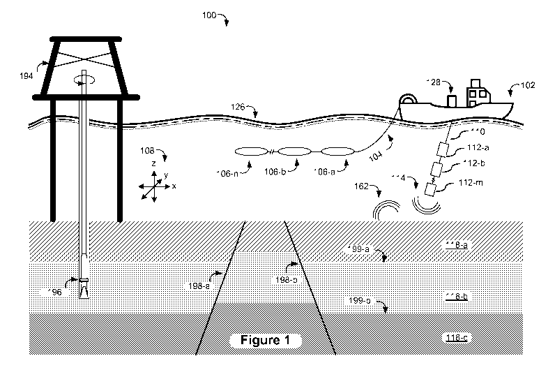
[0023] Figure 1 is a schematic diagram of a marine geophysical exploration
environment 100, in accordance with some embodiments. In marine geophysical
exploration
environment 100, a survey vessel 102 tows one or more seismic streamers (one
exemplary
streamer 104 being depicted in Figure 1) behind the vessel 102. The seismic
streamers 104
may be several thousand meters long and may contain various support cables
(not shown), as
well as wiring and/or circuitry (not shown) that may be used to support
communication along
the streamers 104. In general, a streamer 104 includes a primary cable onto
which seismic
sensors 106 are mounted (e.g., seismic sensor 106-a, 106-b, 106-c through
seismic sensor
106-n) that record seismic signals. Collectively, the recorded seismic signals
constitute
seismic data.
[0024] In some embodiments, the seismic sensors 106 are pressure sensors or
are
multi-component seismic sensors. For the case of multi-component seismic
sensors, each
sensor is capable of detecting a pressure value and at least one component of
a particle
motion that is associated with acoustic signals that are proximate to the
multi-component
seismic sensor. Examples of particle motions include one or more components of
a particle
displacement (e.g., one or more of an in-line (x), a cross-line (y) and/or a
vertical (z)
component as shown in axes 108, for example), one or more components of
particle velocity,
and one or more components of particle acceleration.
[0025] In some embodiments, the multi-component seismic sensor may include
one
or more hydrophones, geophones, particle displacement sensors, particle
velocity sensors,
accelerometers, pressure gradient sensors, or a combination thereof
6
CA 02946711 2016-10-21
WO 2015/187208
PCT/US2015/014732
[0026] For example, in some embodiments, a particular multi-component
seismic
sensor includes a hydrophone for measuring pressure and three orthogonally-
aligned
accelerometers to measure three corresponding orthogonal components of
particle velocity
and/or acceleration near the seismic sensor. It is noted that the multi-
component seismic
sensor may be implemented as a single device or may be implemented as a
plurality of
devices. A particular multi-component seismic sensor may also include one or
more pressure
gradient sensors, which constitute another type of particle motion sensor.
Each pressure
gradient sensor measures the change in the pressure wavefield at a particular
point with
respect to a particular direction. For example, one of the pressure gradient
sensors may
acquire seismic data indicative of, at a particular point, the partial
derivative of the pressure
wavefield with respect to the cross-line direction, and another one of the
pressure gradient
sensors may acquire, at a particular point, seismic data indicative of the
pressure data with
respect to the in-line direction.
[0027] Marine geophysical exploration environment 100 includes one or more
seismic source arrays 110. A source array 110, in turn, includes one or more
strings of
seismic sources such as air guns (e.g., seismic source 112-a, 112-b, 112-c
through seismic
source 112-m). In some embodiments, the seismic sources 112 may be coupled to,
or towed
by, the survey vessel 102. Alternatively, the seismic sources 112 may operate
independently
of the survey vessel 102, in that the source elements 112 may be coupled to,
for example,
other vessels or buoys.
[0028] As the seismic streamers 104 are towed behind the survey vessel 102,
acoustic
signals 114 (sometimes referred to as "shots") are produced by the seismic
sources 112 and
are directed down through a water column 116 into lithographic strata 118
(e.g., lithographic
strata 118-a, 118-b, and 118-c each represent a respective layer, or stratus,
of the geological
medium) beneath a water bottom surface 120. Reflected acoustic signals 122 are
reflected
from the various subterranean geological features, such as horizons 199 (e.g.,
horizon 199-a
represents an interface between lithographic stratus 118-a and lithographic
stratus 118-b).
[0029] The incident acoustic signals 114 produce corresponding reflected
acoustic
signals, or pressure waves, which are sensed by the seismic sensors 106. It is
noted that the
pressure waves that are received and sensed by the seismic sensors 106 include
"up-going"
pressure waves, as well as "down-going" pressure waves that are produced by
reflections of
the pressure waves from an air-water boundary 126.
7
CA 02946711 2016-10-21
WO 2015/187208
PCT/US2015/014732
[0030] The seismic sensors 126 generate signals (digital signals, for
example), called
"traces," which indicate the acquired measurements of the pressure wavefield
and particle
motion (if the sensors are particle motion sensors), e.g., as a function of
time. The traces are
recorded and are, in some embodiments, at least partially processed by a
signal processing
unit 128 that is deployed on the survey vessel 102.
[0031] Well-log data is another source of data that is available, in some
circumstances, to help understand a geological medium. In an example scenario,
a borehole
196 is drilled from a derrick 194. A well-logging sensor obtains well-logging
data along the
path of borehole 196. There are many different types of well-logging sensors,
each capable of
measuring a different physical property of the geological medium along the
path of borehole
196. These include:
= Resistivity well-log sensors that characterize the rock or sediment
around borehole
196 by measuring electrical resistivity along the path of borehole 196;
= Acoustic impedance sensors that measure acoustic impedance to create an
image
along the path of borehole 196;
= Porosity sensors that use acoustic or nuclear technology (e.g., neutron
or gamma ray
sensors) to measure the fraction or percentage pore volume in the rock along
the path
of borehole 196;
= Density sensors that infer rock density along the path of borehole 196 by
measuring
resultant gamma rays after bombarding the rock with a radioactive source; and
= Nuclear magnetic resonance (NMR) sensors that are used to infer, for
example,
porosity and permeability values along the path of borehole 196.
[0032] Many other types of well-log sensors and/or combinations of sensor
types can
be employed. For example, some types of well-log data require core removal at
select
locations along the borehole 196 followed by analysis of said cores in a
laboratory setting.
Also, in accordance with various embodiments, well-logging can be performed in
a logging
while drilling (LWD) configuration or can be performed after drilling borehole
196. These
embodiments are not described in detail for the sake of brevity, but are
nonetheless intended
to fall within the scope of the appended claims.
8
CA 02946711 2016-10-21
WO 2015/187208
PCT/US2015/014732
[0033] A goal of geophysical exploration is to build up an image of a
survey area for
purposes of identifying subterranean geological features (e.g., hydrocarbon
deposits/reservoirs). To that end, an intermediate goal is to develop and
accurate earth model.
The earth models described herein are created by combining several sub-models,
including a
fault model, a horizon model, and a rock property model. In particular, when
faults 198
transect horizons 199, seams are created in horizons 199. The earth models
described herein
capture (e.g., incorporate) such seams into an earth model and assign
accordingly (e.g., map)
the rock properties described by the rock property model. Subsequent analysis
(e.g., forward
modeling by way of reverse time migration) using the earth model may reveal
probable
locations of hydrocarbon deposits in the geological medium.
[0034] In some embodiments, some analysis of geophysical data (e.g.,
seismic or
well-log data) may be performed on the seismic survey vessel 102, such as by
the signal
processing unit 128. In some embodiments, the geophysical data is processed,
at least
partially, by a seismic modeling system (such as an exemplary seismic modeling
system 600
that is depicted in Figure 6 and is further described below) that may be, for
example, located
on land or on the vessel 102. Thus, many variations are possible and are
within the scope of
the appended claims.
[0035] One of ordinary skill in the art will appreciate that the marine
geophysical
exploration environment 100 described above is merely an example of one of
many different
types of seismic data acquisition environments that may be used. For example,
in some
embodiments, a geophysical exploration environment may use stationary sensor
cables that
are disposed on the seabed. As another example, in some embodiments, a
geophysical
exploration environment may be a land-based environment in which sensor cables
are buried
in the earth. Thus, many variations are contemplated and are within the scope
of the
appended claims.
[0036] Figure 2 is an example image of an outcrop of a geological medium.
While the
methods, computer systems, and non-transitory computer readable storage media
provided
herein are described, for the sake of understanding, in the remainder of this
document using
simple examples, the purpose of Figure 2 is to demonstrate that geological
media are, in some
circumstances, quite complex. To that end, the geological medium shown in
Figure 2 is an
example of a geological medium that is modeled using the embodiments described
herein
(e.g., the embodiments described herein are used, in some circumstances, to
generate an earth
9
CA 02946711 2016-10-21
WO 2015/187208
PCT/US2015/014732
model for the geological medium exposed by the outcrop or an analogous
geological
medium). It should be understood, however, that geological media of interests
(e.g., potential
hydrocarbon bearing geological media) are often entirely subterranean, and
therefore such
outcroppings do not exist. Moreover, some embodiments of the present
disclosure are used to
generate three-dimensional models, in which case the complexity shown in
Figure 2
potentially extends throughout a three-dimensional volume.
[0037] To illustrate a specific example of the complexity in building earth
models that
account for faults, horizons, and rock properties, consider that the
geological medium shown
in Figure 2 includes a plurality of faults 602 (e.g., fault 602-a, fault 602-
b, and fault 602-c)
and a plurality of horizons 604 (e.g., horizon 604-a and horizon 604-b).
Horizons 604 are
folded such that they are nearly parallel with faults 602. Many other faults
and horizons are
present in the geological medium, but are not labeled for the sake of clarity.
Where a
respective fault 602 transects a respective horizon 604, a seam 606 is
created. Using
conventional methods, it is difficult to distinguish between, for example, a
steep fold in a
horizon 604 and a seam 606 created by a steeply normal fault 602. But by
combining, in
accordance with some embodiments, a seamless horizon model with a separately
generated
fault model to produce a faulted structural model of the geological medium
(e.g., a horizon
model with seams created by faults), and then assigning rock properties to a
numerical grid or
mesh in accordance with the faulted structural model, the inaccuracies in
conventional three-
dimensional earth models for complex geological media are mitigated.
[0038] Figures 3A-3D illustrate a graphical example of a method of building
complex
earth models, in accordance with some embodiments. While, generally speaking,
the methods
described herein are used to build earth models in which a plurality of
horizons is present, for
illustrative purposes, only a single horizon is shown (e.g., horizon 199-a
from the geological
medium shown in Figure 1). Figures 3A-3D also include the axes 108, previously
shown in
Figure 1, which indicate the in-line (x), cross-line (y), and vertical (z)
directions.
[0039] Figure 3A illustrates a horizon model that includes a single horizon
199-a.
Horizon 199-a is specified in three-dimensions (in general, the shape of a
horizon will vary in
all three directions, e.g., the lateral directions and vertical direction). In
some embodiments,
horizon 199-a is specified with respect to a first grid or mesh (e.g., the
dots in the shading of
horizon 199-a in Figure 3A each represent a point on the grid that belongs to
horizon 199-a).
CA 02946711 2016-10-21
WO 2015/187208
PCT/US2015/014732
Horizon 199-a is initially seamless (e.g., simply-connected) meaning that
there are no holes
in it.
[0040] Figure 3B illustrates a fault model that includes two faults: fault
198-a and
fault 198-b. In some embodiments, faults 198 are also specified with respect
to the first grid.
For reference, horizon 199-a is still shown; however, for clarity, the shading
has been
modified to be lighter as compared to Figure 3A. Faults 198 transect horizon
199-a, meaning
that in the physical geological medium, the physical faults represented by
faults 198 create
seams (e.g., breaks or displacements) in the horizon represented by horizon
199-a. It is those
seams that the present method captures when generating an earth model for the
geological
medium.
[0041] Figure 3C illustrates an operation of determining where faults 198
(Figure 3B)
intersect horizon 199-a. For clarity, faults 198 have been omitted from Figure
3C and horizon
199-a has been returned to its original shading presented in Figure 3A.
Regions 302 (e.g.,
region 302-a and region 302-b) are regions of intersection, meaning that a
determination has
been made that a respective fault 198 coincides with horizon 199-a at each
point within
regions 302. In some embodiments, any point on horizon 199-a's specification
that is within a
predefined distance tolerance of a fault 198 is determined to be within a
region 302 of
intersection. In some embodiments, a nominal region of intersection is
generated by
determining which points on horizon 199-a's specification lie within a
predefined distance
tolerance of a fault 198. In some embodiments, an additional smoothing
operation is
performed on the nominal regions of intersection to generate regions 302 and
assure that the
regions 302 are simply-connected (e.g., there are no holes in them).
[0042] Figure 3D illustrates a faulted structural model of the geological
medium. In
the faulted structural model, the specification of horizon 199-a has been
modified to account
for faults 198 (e.g., the regions 302 have been removed). In some embodiments,
the
specification of horizon 199-a has also been modified by mapping the
specification from a
first numerical grid or mesh to a second numerical grid or mesh that allows
for more precise
and accurate forward modeling of seismic signals given the faulted structure
of the faulted
structural model.
[0043] Figures 4A-4B illustrate warping of a first grid or mesh (e.g., a
numerical grid
or mesh) onto a second grid or mesh. In some embodiments, the first grid,
shown in Figure
11
CA 02946711 2016-10-21
WO 2015/187208
PCT/US2015/014732
4A, comprises a plurality of evenly spaced first spatial (e.g., grid)
locations 402 (certain dots
indicating spatial locations that interfere with reference numbers and/or
arrows have been
omitted for the sake of visual clarity). For example, in some embodiments, the
first grid
includes a plurality of first spatial locations in a three-dimensional volume
evenly spaced by a
predefined distance (e.g., 1 centimeter, 10 centimeters, 1 meter, or 10
meters) in the
geological medium. In some embodiments, the first grid is a finite elements
grid and the first
spatial (e.g., grid) locations represent vertices of finite element volumes.
Alternatively, the
first grid is a finite differencing grid and the first spatial locations
represent calculation
locations.
[0044] As shown in Figure 4B, in some embodiments, the first grid is
remapped
(along with fault, horizon, and rock property specifications) onto a second
grid that includes
one or more second spatial locations and/or lines aligned with a respective
fault that intersects
the respective horizon. For example, the second spatial locations 404
represented by the
hollow circles have been remapped (e.g., warped, or moved) onto faults 198-a
and 198-b.
[0045] Figures 5A-5B are a schematic flowchart of a method 500 of building
complex
earth models, in accordance with some embodiments. Method 500 is, optionally,
governed by
instructions that are stored in computer memory or a non-transitory computer
readable
storage medium (e.g., memory 606 in Figure 6) and are executed by one or more
processors
(e.g., processor(s) 602) of one or more computer systems, including, but not
limited to, signal
processing unit 128 (Figure 1) and/or system 600 (Figure 6). The computer
readable storage
medium may include a magnetic or optical disk storage device, solid state
storage devices
such as flash memory, or other non-volatile memory device or devices. The
computer
readable instructions stored on the computer readable storage medium may
include one or
more of: source code, assembly language code, object code, or another
instruction format that
is interpreted by one or more processors. In various embodiments, some
operations in each
method may be combined and/or the order of some operations may be changed from
the
order shown in the figures. For ease of explanation, method 500 is described
as being
performed by a computer system, although in some embodiments, various
operations of
method 500 are distributed across separate computer systems.
[0046] A computer accesses (502), for a geological medium: a horizon model
including a plurality of horizons in the geological medium (an example horizon
in a horizon
model is shown in Figure 3A); a fault model including a plurality of faults in
the geological
12
CA 02946711 2016-10-21
WO 2015/187208
PCT/US2015/014732
medium (two examples of faults in a fault model are shown in Figure 3B); and a
rock
property model including one or more physical rock properties at a plurality
of spatial
locations on a first grid corresponding to the geological medium. In some
embodiments, the
computer system receives and stores the horizon model, the fault model, and
the rock
property model.
[0047] In some embodiments, the horizons in the horizon model represent
boundaries
between adjacent lithographic strata, or alternatively (in some cases
equivalently), the
horizons represent a respective surface (e.g., the top surface or the bottom
surface) of a
respective lithographic stratus. For example, as shown in Figure 1, horizon
199-a can be
described as a boundary between lithographic stratus 118-a and lithographic
stratus 118-b.
Alternatively, horizon 199-a can be described as atop surface of lithographic
stratus 118-b or
a bottom surface of lithographic stratus 118-a. Variously, the lithographic
strata optionally
include rock strata, sediment strata, and or fluid strata (e.g., representing
ocean). The horizon
model optionally includes one or more free horizons (e.g., representing
seafloor, sea-level,
and/or ground) that, in some circumstances, will transect one or more non-free
horizons (e.g.,
when the lithography is tilted with respect to the seafloor). In some
embodiments, each
horizon in the plurality of horizons is specified in two-dimensions or three-
dimensions with
respect to the first grid or mesh (e.g., a finite element or finite difference
grid or mesh). In
some embodiments, the horizon model represents a present state or structure of
the horizons
(e.g., a state in present geological time, as compared with a state or
structure of the horizons
at a previous geological time when the lithographic strata were deposited). To
that end, the
horizons in the horizon model are, in some circumstances, folded and/or
tilted. However, as
noted below, in some embodiments the horizons in the horizon model are
seamless, meaning
that each horizon is represented by a continuous surface (e.g., each horizon
is represented by
a simply-connected surface). In some embodiments, prior to accessing the
horizon model, the
horizon model is generated by inversion of seismic data and/or geological
interpretation of
seismic data.
[0048] In some embodiments, the faults in the fault model represent breaks
in
lithographic strata with displacement of the lithographic strata on one side
of each fault with
respect to the other side. Faults can be categorized as being primarily normal
(i.e.,
compressive or tensile), or strike-slip (e.g., shear); however, often faults
include more than
one type of character (e.g., a compressive component and a shear component).
In some
13
CA 02946711 2016-10-21
WO 2015/187208
PCT/US2015/014732
embodiments, each fault in the fault model is specified with respect to the
first grid (e.g., the
same grid with which the horizons in the horizon model are specified). Faults
are, in various
embodiments, specified in two-dimensions (2D) or three-dimensions (3D),
depending on the
dimensionality of the first grid. In various embodiments, prior to accessing
the fault model,
the faults in the fault model are generated by interpreting seismic data,
interpreting inverted
seismic data, interpreting seismic sections, and/or using other methodologies
and
combinations of the aforementioned methodologies. In some embodiments,
generating the
faults in the fault model includes specifying the faults with respect to the
first grid. The
specification is achieved, in various embodiments, by having a geologist hand
pick specific
fault locations and having a computer interpolate between said fault locations
(e.g., using the
seismic data), or through fully-automated computer methods.
[0049] In some embodiments, the physical rock properties in the rock
property model
include, for each point on the first grid, a value for one or more of: a p-
wave velocity Vp, an
s-wave velocity Vs, the Thomsen parameters 6 and c, density p, and/or an
attenuation factor Q
(e.g., when the rock property model includes an attenuation model). In some
circumstances,
the geological medium is anisotropic and the rock property model specifies,
for each point on
the first grid, two or more values for the p-wave velocity (e.g., Vpõ, Vpy,
and Vpz). In an
analogous fashion, in some embodiments, two or more values are specified for
other rock
properties for each point on the first grid as well. In some embodiments, the
values of the
rock property model are determined by combining values obtained from low-
frequency
seismic data with high-frequency well-log data. For example, in some
embodiments, the rock
model includes (504): a low-frequency sub-model (e.g., sometimes called a DC
model, where
DC stands for "direct current" in an analogy to electrical signal processing)
indicating a depth
trend for the one or more physical rock properties that is determined in
accordance with
seismic data that is extrapolated onto the first grid, and a high-frequency
sub-model
indicating fluctuations in the one or more physical rock properties that are
determined in
accordance with well-log data that is extrapolated onto the first grid. For
example, in some
embodiments, porosity is measured at a plurality of depths along a borehole
within the
geological medium, yielding a depth trend. In some embodiments, the high-
frequency sub-
model is used to account for (e.g., calculate) lateral fluctuations (e.g.,
perturbations, also
called "fine-structure," in the lateral directions) away from the depth trend.
In some
embodiments, the calculation is done using an optimization algorithm (routine)
that attempts
to minimize a residual data (e.g., residual travel-time data, or residual
amplitude data) once
14
CA 02946711 2016-10-21
WO 2015/187208
PCT/US2015/014732
the depth trend has been considered. In some embodiments, the depth trend
describes a one-
dimensional rock property trend.
[0050] In some embodiments, the complex earth model built (e.g., generated)
by
method 500 includes two volumes: a first volume that represents the geological
medium and
a second volume which represents a non-physical boundary region. The purpose
of the non-
physical boundary volume is to avoid spurious artifacts that arise when the
earth model is
used to simulate propagation of seismic waves in a finite volume (e.g.,
spurious artifacts
arising from non-physical boundary conditions). To that end, in some
embodiments, the
second volume includes an attenuation (Q) profile and velocity profiles that
are design (e.g.,
constructed, contrived) to avoid reflecting and/or refracting simulated
seismic energy back
into the first volume when said seismic energy reaches the edges of the first
volume.
[0051] In some embodiments, the horizon model, fault model, and rock
property
model are accessed by a software platform such as SKUAO developed by Paradigm
(SKUA stands for Subsurface Knowledge Unified Approach and is a computing
environment
and software suite for modeling geological media). In some embodiments, the
horizon model,
fault model, and rock property model are generated by a module of the software
platform and
accessed (e.g., received) by a different module of the software platform.
[0052] Further to method 500, the computer system determines (506) one or
more
intersections (e.g., regions of intersection) between respective horizons of
the horizon model
and respective faults of the fault model by correlating the horizon model with
the fault model
(an example of two regions of intersection, each between a horizon and a
respective fault, is
shown Figure 3C). In some embodiments, determining an intersection between a
fault and a
respective horizon includes determining, for each point on the respective
horizon (e.g., as
specified with respect to the first grid), whether the point falls within a
predefined distance
tolerance (e.g., 10 centimeters, 1 meter, 2 meters, or 5 meters) of the fault.
Those points that
are within the predefined distance tolerance of the fault are then considered
(e.g., determined
to be) within a region of intersection. In some embodiments, determining an
intersection
between a fault and a respective horizon includes determining an intersecting
path (e.g., a
one-dimensional path specified in a three-dimensional volume) and determining
an offset
magnitude and offset direction of the fault.
CA 02946711 2016-10-21
WO 2015/187208
PCT/US2015/014732
[0053] The computer system calculates (508) a faulted structural model for
the
geological medium in accordance with the one or more determined intersections
between
respective horizons of the horizon model and respective faults of the fault
model (a simple
example of a faulted structural model is shown in Figure 3B). In some
embodiments, the
horizons in the plurality of horizons in the accessed fault model are (510)
seamless horizons
(e.g., represented by smooth, or simply-connected, surfaces). Calculating the
structural model
includes modifying a respective horizon of the plurality of horizons to
include a seam, or a
plurality of seams (e.g., by removing portions of the horizon), that
corresponds to a respective
intersection of a fault with the respective horizon. For example, in some
embodiments, the
regions of intersection that are determined in operation 504 are removed from
the respective
horizon. Alternatively, in some embodiments, portions of a respective horizon
are removed in
accordance with an intersection path and an offset magnitude and offset
direction of the
intersecting fault. Thus, a horizon that originally looks like the horizon
shown in Figure 3A is
modified to look like the horizon shown in Figure 3D.
[0054] In some embodiments, as noted above, a respective horizon of the
horizon
model is specified (512) with respect to the first grid. Calculating the
structural model
includes remapping the respective horizon onto a second grid distinct from the
first grid, the
second grid including a plurality of second spatial locations, one or more of
said second
spatial locations being aligned with a respective fault that intersects the
respective horizon. In
some embodiments, the first grid and second grid are finite difference grids
and the second
grid includes a plurality of grid locations (e.g., connected by grid lines)
aligned along the
respective fault (e.g., the second grid is constructed so as to capture the
sharp changes in rock
properties produced by the faults). In some embodiments, the first grid and
the second grid
are finite element grids and the second grid includes a plurality of finite
element volumes
having edges aligned with the respective fault. In this manner, the horizons
in the horizon
model and/or the faults in the fault model are remapped from the first grid to
a second grid
that is consistent with their intersection.
[0055] The computer system generates (514) an earth model for seismic
forward
modeling by assigning one or more physical rock properties to the faulted
structural model in
accordance with the rock property model. For example, in some embodiments, the
computer
system also remaps (516) the rock model onto the second grid. In some
embodiments, the
computer system warps the rock properties onto the second grid (or the first
grid, if a second
16
CA 02946711 2016-10-21
WO 2015/187208
PCT/US2015/014732
grid is not employed). This is realized, in some embodiments, by interpolating
values of the
rock properties specified with respect to the first grid to locations on the
second grid (e.g.,
that are not on the first grid). Alternatively, the geological medium is
modeled using a "layer
cake" model in which rock properties are established as constant within
respective
lithographic strata. In this case, the remapping of rock model properties onto
the second grid
is realized by defining regions corresponding to respective lithographic
strata (e.g., in
accordance with the horizons and faults), and assigning rock properties based
on the strata
corresponding to each second grid location. In some embodiments, the earth
model is (518) a
three-dimensional model. To that end, in various embodiments, one, two, or all
three of the
horizon model, the fault model, and the rock property model, are specified in
three-
dimensions so that the generated earth model is also specified in three-
dimensions.
[0056] In some embodiments, the computer system calculates (520), using the
earth
model, a velocity model for the geological medium. In some embodiments, the
generated
earth model (see operation 514) specifies a density at each location on the
second grid. In
some embodiments, the computer system generates a model that includes values
for the Lame
parameters 2, and la at each point on the computational grid. The computer
system uses a
mathematical relationship to calculate a velocity model. One such relationship
is Gardner's
relation, given below:
p = AvpB , (1)
where p is the density at a location in the geological medium, Vp is the p-
wave velocity at the
location in the geological medium, A and B are constants with typical values
of A = 0.23 and
B = 0.25.
[0057] Alternatively, the p-wave velocity can be calculated from the Lame
parameters 2, and la using the relation:
_ \IA+21.1. (2)
Vp - .
P
[0058] More generally speaking, in some embodiments, the computer system
generates an earth model in operation 514 that describes one or more first
rock properties at
each location on a computational grid, and the computer system then calculates
in operation
520 a model for a distinct set of one or more second rock properties for each
location on the
17
CA 02946711 2016-10-21
WO 2015/187208
PCT/US2015/014732
computational grid (i.e., meaning that at least one of the second rock
properties is different
than, or not among, the first rock properties).
[0059] In some embodiments, the computer system propagates (522) one or
more
seismic signals through the geological medium in accordance with the velocity
model. In
some embodiments, propagating the one or more seismic signals through the
geological
medium comprises (524) forward modeling of the one or more seismic signals.
The operation
of propagating (e.g., time-stepping, or forward modeling) the one or more
seismic signals can
be viewed as an operation of calculating, for each location on a computational
grid (e.g., the
first grid or the second grid), and at each of a plurality or sequence of
times, at least one
seismic wavefield resulting from the seismic signals. A seismic wavefield is a
representation
of the state of seismic waves in the geological medium (e.g., a wavefield
represents
displacement magnitudes and directions at each location on the computational
grid). Two
important aspects of wavefield propagation are an earth model, which has been
described
above, and a governing system of one or more propagation equations. In some
embodiments,
the governing system of one or more propagation equations used to propagate
the one or
more seismic signals comprises a system of equations that approximate the
fully elastic wave
equation. In addition, an attenuation (Q) model is used, in some embodiments,
to simulate
inelastic losses in the geological medium.
[0060] In some embodiments, synthetic (e.g., approximated) source signals
(e.g.,
wavelets) are propagated through the geological medium to receiver locations
in order to
simulate received seismic data. The simulated received seismic data is then
compared to
measured seismic data (e.g., measured at the receiver locations) in order to
iteratively refine
the earth model. In some embodiments, the forward modeling comprises (526)
reverse time
migration (RTM) and is used to increase the resolution of seismic sections
produced during
geophysical exploration scenarios (see Figure 1).
[0061] Figure 6 is a block diagram illustrating a seismic modeling system
600, in
accordance with some embodiments. While certain specific features are
illustrated, those
skilled in the art will appreciate from the present disclosure that various
other features have
not been illustrated for the sake of brevity and so as not to obscure more
pertinent aspects of
the embodiments disclosed herein.
18
CA 02946711 2016-10-21
WO 2015/187208
PCT/US2015/014732
[0062] To that end, the seismic modeling system 600 includes one or more
processing
units (CPU's) 602, one or more network or other communications interfaces 608,
memory
606, and one or more communication buses 604 for interconnecting these and
various other
components. The seismic modeling system 600 also optionally includes one or
more seismic
sensors 106 (e.g., geophones and/or hydrophones) and optionally includes one
or more
seismic sources 112 (e.g., air-guns). The communication buses 604 may include
circuitry
(sometimes called a chipset) that interconnects and controls communications
between system
components. Memory 606 includes high-speed random access memory, such as DRAM,
SRAM, DDR RAM or other random access solid state memory devices; and may
include
non-volatile memory, such as one or more magnetic disk storage devices,
optical disk storage
devices, flash memory devices, or other non-volatile solid state storage
devices. Memory 606
may optionally include one or more storage devices remotely located from the
CPU(s) 602.
Memory 606, including the non-volatile and volatile memory device(s) within
memory 606,
comprises a non-transitory computer readable storage medium.
[0063] In some embodiments, memory 606 or the non-transitory computer
readable
storage medium of memory 606 stores the following programs, modules and data
structures,
or a subset thereof including an operating system 616, a network communication
module 618,
and a seismic modeling module 620.
[0064] The operating system 616 includes procedures for handling various
basic
system services and for performing hardware dependent tasks.
[0065] The network communication module 618 facilitates communication with
other
devices (e.g., facilitates communication with the seismic sources 112 and/or
the seismic
sensors 106 if not included in the system 600, or facilitates communication
with other land-
based components) via the communication network interfaces 608 (wired or
wireless) and
one or more communication networks, such as the Internet, other wide area
networks, local
area networks, metropolitan area networks, and so on (e.g., in some
embodiments, seismic
modeling system 600 is located remotely from the seismic sources 112 and/or
seismic sensors
106).
[0066] In some embodiments, the seismic modeling module 620 is configured
to
access (e.g., and store in data sub-module 626), for a geological medium: a
horizon model
626-1 including a plurality of horizons in the geological medium; a fault
model 626-2
19
CA 02946711 2016-10-21
WO 2015/187208
PCT/US2015/014732
including a plurality of faults in the geological medium; and a rock property
model 626-3
including one or more physical rock properties at a plurality of spatial
locations on a first grid
corresponding to the geological medium. The seismic modeling module 620
includes a model
registering sub-module 624 (which includes a set of instructions 624-1 and
optionally
metadata and parameters 624-2) that merges the three models. For example,
model
registering sub-module 624 correlates horizon model 626-1 with fault model 626-
2 in order
to determine one or more intersections between respective horizons of the
horizon model and
respective faults of the fault model. The model registering sub-module 624
then calculates a
faulted structural model for the geological medium in accordance with the one
or more
determined intersections between respective horizons of the horizon model and
respective
faults of the fault model, and generates an earth model for seismic forward
modeling by
assigning one or more physical rock properties to the faulted structural model
in accordance
with rock property model 626-3.
[0067] In some embodiments, the seismic modeling module 620 propagates one
or
more seismic wavefields (e.g., propagates one or more seismic signals) using a
propagation
sub-module 622 (which includes a set of instructions 622-1 and optionally
metadata and
parameters 622-2). Propagation of seismic signals is described in greater
detail with reference
to method 500, Figure 5.
[0068] While particular embodiments are described above, it will be
understood it is
not intended to limit the invention to these particular embodiments. On the
contrary, the
invention includes alternatives, modifications and equivalents that are within
the spirit and
scope of the appended claims. Numerous specific details are set forth in order
to provide a
thorough understanding of the subject matter presented herein. But it will be
apparent to one
of ordinary skill in the art that the subject matter may be practiced without
these specific
details. In other instances, well-known methods, procedures, components, and
circuits have
not been described in detail so as not to unnecessarily obscure aspects of the
embodiments.
[0069] The terminology used in the description of the invention herein is
for the
purpose of describing particular embodiments only and is not intended to be
limiting of the
invention. As used in the description of the invention and the appended
claims, the singular
forms "a," "an," and "the" are intended to include the plural forms as well,
unless the context
clearly indicates otherwise. It will also be understood that the term "and/or"
as used herein
refers to and encompasses any and all possible combinations of one or more of
the associated
CA 02946711 2016-10-21
WO 2015/187208
PCT/US2015/014732
listed items. It will be further understood that the terms "includes,"
"including," "comprises,"
and/or "comprising," when used in this specification, specify the presence of
stated features,
operations, elements, and/or components, but do not preclude the presence or
addition of one
or more other features, operations, elements, components, and/or groups
thereof
[0070] As used herein, the term "if' may be construed to mean "when" or
"upon" or
"in response to determining" or "in accordance with a determination" or "in
response to
detecting," that a stated condition precedent is true, depending on the
context. Similarly, the
phrase "if it is determined [that a stated condition precedent is truer or "if
[a stated condition
precedent is truer or "when [a stated condition precedent is truer may be
construed to mean
"upon determining" or "in response to determining" or "in accordance with a
determination"
or "upon detecting" or "in response to detecting" that the stated condition
precedent is true,
depending on the context.
[0071] Although some of the various drawings illustrate a number of logical
stages in
a particular order, stages that are not order dependent may be reordered and
other stages may
be combined or broken out. While some reordering or other groupings are
specifically
mentioned, others will be obvious to those of ordinary skill in the art and so
do not present an
exhaustive list of alternatives. Moreover, it should be recognized that the
stages could be
implemented in hardware, firmware, software or any combination thereof
[0072] The foregoing description, for purpose of explanation, has been
described with
reference to specific embodiments. However, the illustrative discussions above
are not
intended to be exhaustive or to limit the invention to the precise forms
disclosed. Many
modifications and variations are possible in view of the above teachings. The
embodiments
were chosen and described in order to best explain the principles of the
invention and its
practical applications, to thereby enable others skilled in the art to best
utilize the invention
and various embodiments with various modifications as are suited to the
particular use
contemplated.
21