Note: Descriptions are shown in the official language in which they were submitted.
CA 02955343 2017-01-16
DETERMINING ONE OR MORE PARAMETERS OF A
WELL COMPLETION DESIGN BASED ON DRILLING DATA CORRESPONDING
TO VARIABLES OF MECHANICAL SPECIFIC ENERGY
BACKGROUND
1. Field
[0001] Embodiments disclosed herewith generally relate to well drilling and
completion and,
more specifically, to methods for determining one or more parameters of a well
completion
design.
2. Description of the Related Art
[0002] The following descriptions and examples are not admitted to be prior
art by virtue of
their inclusion within this section.
[0003] Wells are drilled for a variety of reasons, including the extraction of
a natural resource
such as ground water, brine, natural gas, or petroleum, for the injection of a
fluid to a
subsurface reservoir or for subsurface evaluations. Before it can be employed
for its intended
use, a well must be prepared for its objective after it has been drilled. The
preparation is
generally referred to in the industry as the well completion phase and
includes casing the
drilled well to prevent its collapse as well as other processes specific to
the objective of the
well and/or the geomechanical properties of the rock in which the well is
formed. For
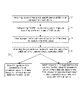
example, typical well completion processes for oil and gas wells may include
perforating,
hydraulic fracturing (otherwise known as 'Tracking") and/or acidizing.
[0004] In many cases, the efficacy of a well depends on the implementation of
the well
completion phase. For instance, it has been found that a well completed
according to the
geomechanical properties of rock along the trajectory of the well is generally
more effective
for its intended use than a well completed assuming the rock is homogeneous
and isotropic. In
particular, a wellbore used to extract a natural resource generally has higher
production when
it is completed based on geomechanical properties of the rock along its
trajectory rather than
when the rock is assumed to be homogeneous and isotropic. Designing a well
completion
phase based on geomechanical properties of rock, however, is time consuming
and expensive,
particularly in horizontal wells. Furthermore, return on investment is often
unknown when
1
CA 02955343 2017-01-16
designing a well completion phase based on geomechanical properties of rock.
Given such
uncertainty and the drive in the industry to reduce completion costs, most
well operators
choose to implement a well completion design which assumes the rock along a
wellbore
trajectory is homogeneous and isotropic.
[0005] Therefore, it would be advantageous to develop a method for determining
one or more
parameters of a well completion design for at least a portion of a drilled
well that causes little
or no delay between the drilling and completion phases of the well. It would
be further
beneficial for such a method to be relatively low cost and deliver higher
efficacies relative to
wells completed on the assumption that the rock along the wellbore trajectory
is homogeneous
and isotropic.
SUMMARY
[0005a] Certain exemplary embodiments can provide a method, comprising:
acquiring values
of mechanical specific energy (MSE) for at least a portion of a drilled well;
and determining
one or more parameters of a well completion design for at least the portion of
the drilled well
based on the MSE values.
[0005b] Certain exemplary embodiments can provide a method, comprising:
acquiring data
regarding a drilling operation of a well, wherein the data comprises values
for variables
correlating directly to mechanical specific energy (MSE), and wherein the
variables comprise
rate of penetration, rotary speed, weight on bit, applied torque, and bit
diameter or bit face
area; identifying distortions among the acquired data which are not related to
geomechanical
properties of rock drilled in the well; generating an altered set of values
for the variables by
amending some of the acquired data to substantially neutralize the
distortions; and
determining one or more parameters of a well completion design for at least a
portion of the
drilled well based on the altered set of values for the variables.
[0005c] Certain exemplary embodiments can provide a storage medium comprising
program
instructions which are executable by a processor for: receiving data regarding
a drilling
operation of a well; calculating values of mechanical specific energy (MSE)
from the received
data; creating a geomechanical model of at least a portion of the well based
at least in part on
the calculated MSE values; and determining one or more parameters of a well
completion
design for at least the portion of the drilled well from the geomechanical
model.
2
CA 02955343 2017-01-16
[0006] The following description of various embodiments of methods and storage
mediums is
not to be construed in any way as limiting the subject matter of the appended
claims.
[0007] Embodiments of methods for determining one or more parameters of a well
completion design for at least a portion of a drilled well based on drilling
data corresponding
to variables of mechanical specific energy (MSE) are provided. In some cases,
the methods
include acquiring values of mechanical specific energy (MSE) for at least the
portion of the
drilled well and determining one or more parameters of the well completion
design based on
the MSE values. In some cases, the MSE values may be obtained from a provider.
In other
embodiments, the MSE values may be acquired by obtaining data regarding a
drilling
operation of the well and calculating the values of MSE via the data. In any
case, some of the
drilling data may be amended prior to determining parameter/s of the well
completion design
to substantially neutralize distortions of the data which are not related to
geomechanical
properties of rock drilled in the well. In some embodiments, the methods may
include creating
a geomechanical model of at least the portion of the well from the acquired
MSE values and
determining one or more parameters of the well completion design from the
geomechanical
model. In some cases, the geomechanical model may be amended prior to
determination of
the one or more parameters of the well completion design to substantially
neutralize
distortions of MSE values resulting from drilling data which is not related to
geomechanical
properties of rock drilled in the well. In addition or alternatively, the
geomechanical model
may be amended in view of data that is not typically encompassed by the
calculation of MSE.
Storage mediums having program instructions which are executable by a
processor for
performing any steps of the disclosed methods are also provided.
BRIEF DESCRIPTION OF THE DRAWINGS
[0008] Other objects and advantages of selected embodiments will become
apparent upon
reading the following detailed description and upon reference to the
accompanying drawings
in which:
3
CA 02955343 2017-01-16
[0009] Fig. 1 is a schematic diagram of a storage medium having program
instructions which
are executable by a processor for processing input of drilling data and/or
values of mechanical
specific energy (MSE) of at least a portion of a drilled well and determining
for output of one
or more parameters and/or a geomechanical model for at least the portion of
the well;
[0010] Fig. 2 is a flowchart of a method for acquiring MSE values for at least
a portion of a
drilled well and determining one or more parameters of a well completion
design for at least
the portion of the well;
[0011] Fig. 3 is a flowchart of a method for obtaining data regarding a
drilling operation of a
well and calculating MSE values via the data;
[0012] Fig. 4 is a portion of a geomechanical model in which locations of
perforation clusters
of a well completion design have been designated based on MSE values
corresponding to a
drilling operation of a well;
[0013] Fig. 5 is the portion of the geomechanical model depicted in Fig. 4
subsequent to the
lengths of subsets of the geomechanical model being amended;
[0014] Fig. 6 is a portion of a geomechanical model in which lengths of
subsets of the
geomechanical model have been demarcated based on MSE values corresponding to
a drilling
operation of a well;
[0015] Fig. 7 is a portion of a geomechanical model in which quantities of
perforation
clusters of a well completion design have been designated per subset of the
geomechanical
model based on MSE values corresponding to a drilling operation of a well; and
[0016] Fig. 8 is a portion of a geomechanical model in which one or more
fracking
parameters of a fracking operation of a well completion design have been
defined per fracking
stage of the geomechanical model based on MSE values corresponding to a
drilling operation
of a well.
[0017] While the invention is susceptible to various modifications and
alternative forms,
specific embodiments thereof are shown by way of example in the drawings and
will herein
be described in detail. It should be understood, however, that the drawings
and detailed
description thereto are not intended to limit the invention to the particular
folin disclosed, but
on the contrary, the intention is to cover all modifications, equivalents and
alternatives falling
within the scope of the present invention as defined by the appended claims.
4
CA 02955343 2017-01-16
DETAILED DESCRIPTION OF THE PREFERRED EMBODIMENTS
[0018] Provided herein are methods and storage mediums having processor-
executable
program instructions for determining one or more parameters of a well
completion design
based on drilling data corresponding to variables of mechanical specific
energy (MSE). In
particular, the methods and storage mediums described herein take advantage of
the close
relationship between MSE and rock strength:
Rock Strength -,-=-== MSE * Deff (Eq. 1)
Where Deff¨efficiency of transmitting the penetration power of the drilling
rig to the rock and
Rock Strength refers to various strength properties of rock, such as but not
limited to
unconfined compressive strength, confined compressive strength, tensile
strength, modulus of
elasticity, stiffness, brittleness and/or any combination thereof.
[0019] MSE is often computed and monitored in real time during a drilling
operation of a
well to maximize drilling efficiency (i.e., by keeping MSE as low as possible
and the rate of
penetration as high as possible via changes to drilling parameters such as
weight on bit,
revolutions per minute, torque and/or differential pressures or changing out
the drill bit for a
new or different bit). Given its correlation to rock strength, changes in MSE
during a drilling
operation of a well may be indicative of substantial changes in rock
properties, but it is
difficult to confirm such a cause due to the several possibilities which may
induce drilling
inefficiencies during a drilling operation (such as but not limited to dull or
damaged bits, poor
mud circulation, and/or vibrations). As such, MSE is generally not used to
decipher reservoir
properties within a well during a drilling operation. Rather, if knowledge of
reservoir
properties along a trajectory of a well is desired to enhance a drilling
operation, other rock
analysis techniques, such as gamma ray and compressive full waveform acoustic
measurements are generally used.
4a
CA 02955343 2017-01-16
WO 2016/010667 PCT/US2015/036190
[0020] The methods and storage mediums disclosed herein, however, differ from
such
practices in that variations of MSE are evaluated for the determination of
parameter/s of a well
completion design. In particular, it is well understood that one of the
largest contributors to the
variability of well production is the variation in stress between neighboring
perforation clusters
within a given stage (i.e., larger variations of stress between neighboring
perforation clusters
generally yield lower production). As such, the methods and the storage
mediums described
herein function to characterize the geological heterogeneity within relatively
short portions of a
well. In general, the methods and storage mediums described herein are based
on the reasonable
presumption that the Deff factor for a drilling rig will remain reasonably
constant in a short
interval (e.g., < 500 feet) of the well, such as a hydraulic fracturing stage
(also known as a frack
stage). In doing so, MSE can be used as a reliable qualitative predictor of
rock strength within a
short interval of the well and, thus, zones of comparable rock strength can be
identified for the
placement of perforation clusters and/or the determination of other
parameter/s of a well
completion design.
[0021] As set forth in more detail below, the one or more parameters of a well
completion
design determined by the methods and storage mediums described herein may
relate to
perforating operations and/or fracking operations of the well completion
design. In some cases,
the methods and storage mediums disclosed herein may be used to create a
geomechanical model
based on MSE and then one or more parameters of a well completion design may
be determined
based on the geomechanical model. In general, parameters of perforating
operations may
include locations and/or quantities of perforation clusters. Parameters of
fracking operations
may include locations or lengths of fracking stages and/or parameters to
induce hydraulic
fracturing and/or to maintain fractures (e.g., required hydraulic horsepower,
fracturing fluid
selection, proppant type). It is noted that although the methods and storage
mediums disclosed
herein are described particularly in reference to well completion designs
employing fracking
operations, the methods and storage mediums are not necessarily so restricted.
In particular, the
methods and storage mediums disclosed herein may be employed to determine
parameter/s of a
well completion design which does not involve hydraulic fracturing operations.
Furthermore,
although the methods and storage mediums described herein concentrate on
determining
parameters of perforating operations and/or fracking operations of well
completion phases, the
methods and storage mediums described herein are not so limited. In
particular, the methods and
CA 02955343 2017-01-16
WO 2016/010667 PCT/US2015/036190
storage mediums described herein may be used to determine parameters of other
operations of
well completion phases, such as but not limited to the placement of fracturing
sleeves.
[0022] Furthermore, although the methods and storage mediums disclosed herein
are described
particularly in reference to well completion designs for horizontal portions
of wells (i.e., wells
which are parallel to or are angled less than or equal to 45 degrees relative
to the earth's surface),
the methods and storage mediums may be additionally or alternatively used for
vertical portions
of wells (i.e., wells which are substantially perpendicular to or are angled
between 45 degrees
and 90 degrees relative to the earth's surface). Moreover, even though the
methods and storage
mediums disclosed herein are described particularly in reference to
determining parameter/s of
well completion designs for the extraction of petroleum from a well,
particularly shale oil, the
methods and storage mediums are not so limited. For example, the methods and
storage
mediums disclosed herein may be alternatively used for determining parameter/s
of well
completion design for the extraction of natural gas, brine or water from a
well. In yet other
cases, the methods and storage mediums disclosed herein may be used for
determining
parameters of a fluid disposal well.
[0023] Furthermore, although the methods and storage mediums disclosed herein
are described
herein for determining one or more parameters of a well completion design
based on values of
MSE, the methods and storage mediums need not be so limited. In particular,
the methods and
storage mediums disclosed herein may be used to determine one or more
parameters of a well
completion design based on any correlation of drilling data which corresponds
to variables of
MSE. As set forth in more detail below, MSE is defined as the energy input per
unit rock
volume drilled and is generally computed via two components, a thrust
component and a rotary
component. The emphasis of either of the two components changes for different
drilling
applications, lending to different MSE equations being employed. For example,
horizontal
portions of wells are often drilled using mud motors, variables of which
affect the rotary
component of MSE, particularly flow rate through the mud motor (e.g.,
gallons/minute), mud
motor speed to flow ratio (e.g., revolutions per gallon) and differential
pressure.
[0024] It was discovered during the development of the methods and storage
mediums
disclosed herein that the rotary component of an MSE equation including such
mud motor
variables often accounts for more than 99% of the total value of MSE and,
thus, variables
associated with a thrust component of the equation, such as weight on bit, may
not contribute
6
CA 02955343 2017-01-16
WO 2016/010667 PCT/US2015/036190
significantly to the MSE value in some cases. In light of this, it is
contemplated that instead of
determining one or more parameters of a well completion design based on values
of MSE,
methods and storage mediums could be developed to determine one or more
parameters of a well
completion design based on a rotary component of MSE. Alternatively, methods
and storage
mediums could be developed to determine one or more parameters of a well
completion design
based on a computation alternative to MSE, but which incorporates the rotary
component of
MSE. For example, a computation which assumes a constant value for the thrust
component of
MSE could be used.
[0025] It was further discovered during the development of the methods and
storage mediums
disclosed herein that in many cases rotational speed of a drill and flow rate
of a mud motor often
fluctuate very little while drilling a horizontal portion of a well and, thus,
such variables could be
assumed constant for some calculations. In light of such information, methods
and storage
mediums could be developed to determine one or more parameters of a well
completion design
based on some correlation of one or more of the remaining variables of the
rotary component for
MSE, such as rate of penetration and differential pressure. It is noted that
while the
aforementioned observations regarding variables associated with a thrust
component of an MSE
equation and minor fluctuations among rotational speed of a drill and flow
rate of a mud motor
are true for most drilling operations, they are not exclusively true for all
drilling operations.
Thus, reviewing the drilling data to determine whether such data regularities
exist before use of
the alternative computations set forth above may be prudent in some cases.
[0026] Regardless of the basis used to determine one or more parameters of a
well completion
design, one or more steps of the methods described herein may be computer
operated and, thus,
storage mediums having program instructions which are executable by a process
for performing
one or more of the method steps described herein are provided. In general, the
term "storage
medium", as used herein, refers to any electronic medium configured to hold
one or more set of
program instructions, such as but not limited to a read-only memory, a random
access memory, a
magnetic or optical disk, or magnetic tape. The term "program instructions"
generally refers to
commands within software which are configured to perform a particular
function, such as
receiving and/or processing drilling data and/or MSE values, creating a
geomechanical model
and/or determining one or more parameters of a well completion design as
described in more
detail below. Program instructions may be implemented in any of various ways,
including
7
CA 02955343 2017-01-16
WO 2016/010667 PCT/US2015/036190
procedure-based techniques, component-based techniques, and/or object-oriented
techniques,
among others. For example, the program instructions may be implemented using
ActiveX controls,
C++ objects, JavaBeans, Microsoft Foundation Classes ("MFC"), or other
technologies or
methodologies, as desired. Program instructions implementing the processes
described herein
may be transmitted over on a carrier medium such as a wire, cable, or wireless
transmission link.
It is noted that the storage mediums described herein may, in some cases,
include program
instructions to perform processes other than those specifically described
herein and, therefore,
the storage mediums are not limited to having program instructions for
performing the operations
described in reference to Figs. 2-8.
[0027] A schematic diagram of storage medium 10 having program instructions 12
which are
executable by processor 14 to determine one or more parameters of a well
completion design
based on drilling data corresponding to variables of MSE is illustrated in
Fig. 1. As shown in
Fig. 1, program instructions 12 are executable by processor 14 to receive
drilling data and/or
MSE values 16. In embodiments in which program instructions 12 receive MSE
values, the
MSE values may, in some cases, be acquired from a data file in a memory of a
computer in
which storage medium 10 resides. In yet other cases, the MSE values may be
acquired from a
separate entity, such as the drilling operator of a well, a separate software
program, or an
intermediary agency. In other cases, program instructions 12 may include
commands to
calculate MSE values from drilling data corresponding to variables of MSE
received by program
instructions 12. In yet other embodiments, program instructions 12 may include
commands to
correlate drilling data which correspond to variables of MSE in a manner other
than calculating
MSE. In either case, program instructions 12 may include commands to amend
some of the
drilling data prior to calculating MSE or correlating the data in another
manner. In any case, the
drilling data received by program instructions 12 may include raw field data
(i.e., data collected
while drilling the well) and/or data processed and/or amended from raw field
data. Furthermore,
in addition to including data which corresponds to variables of MSE, the
drilling data may
include data regarding a drilling operation of a well which does not
correspond to variables of
MSE. Moreover, regardless of whether program instructions 12 receives the
drilling data and/or
MSE values, the data/values may correspond to an entire well or may be for a
portion of a well.
[0028] As shown in Fig. 1 and described in more detail below, program
instructions 12 are
executable by processor 14 to process the received drilling data and/or MSE
values to determine
8
CA 02955343 2017-01-16
WO 2016/010667 PCT/US2015/036190
one or more parameters of a well completion design and/or create a
geomechanical model for at
least the portion of a well for output 18. Output 18 may be displayed on a
screen connected (i.e.,
wired or wireless connection) to a computer comprising storage medium 10
and/or may be sent
to an accessible data file in memory of a computer comprising storage medium
10. In addition
or alternatively, output 18 may be sent to a screen or memory of an electronic
device connected
to the computer comprising storage medium 10. In some cases, output 18 may be
fixed
information (i.e., output 18 may not be amended as displayed and/or within its
data file). In yet
other embodiments, however, output 18 may be changeable, either via a user
interface of a
computer comprising storage medium 10 or via additional program instructions
of storage
medium 10 or a different storage medium. Allowing output 18 to be changeable
may be
advantageous for fine tuning parameter/s of a well completion design and/or
developing and
saving different well completion designs based on output 18.
[0029] A more detailed description of manners in which drilling data and/or
MSE values may
be manipulated and/or evaluated to determine one or more parameters of a well
completion
design and/or create a geomechanical model for at least the portion of a well
are provided below
in reference to Figs. 2-8. In addition, examples of parameters of a well
completion design which
may be determined from MSE values or data corresponding to variables of MSE
are described in
more detail below in reference to Figs. 4-8. Although Figs. 2-8 are described
in reference to
methods, any of such processes may be integrated into processor-executable
program
instructions and, thus, the processes described in reference to Figs. 2-8 are
interchangeable in
reference to processor-executable program instructions for performing such
processes.
[0030] Turning to Fig. 2, a flowchart of a method for determining one or more
parameters of a
well completion design for at least the portion of a well is illustrated. As
shown in block 20, the
method may include acquiring values of MSE for at least a portion of a drilled
well. The term
"acquire" as used herein is defined as the gain of information and is
inclusive to both
obtaining/procuring information from a separate entity or
computing/determining the
information based on received data. Thus, in some cases, the MSE values may be
obtained from
a separate entity, such as the drilling operator of a well, a separate
software program, or an
intermediary agency. In other cases, the MSE values may be calculated from
drilling data
corresponding to variables of MSE. A flowchart of this latter scenario is
illustrated in Fig. 3 and
described in more detail below denoting several optional steps for amending
the obtained data
9
CA 02955343 2017-01-16
WO 2016/010667 PCT/US2015/036190
prior to calculating values of MSE. Regardless of the manner in which MSE
values are acquired,
the drilling data and MSE values may correspond to an entire well or may be
for a portion of a
well. In some cases, it may be advantageous to limit the drilling data and/or
MSE values to a
corresponding area of interest of the well to minimize data processing. For
example, the
horizontal portion of a well may be an area of interest for the extraction of
oil from shale rock.
Likewise, a lowermost portion of a vertical well may be an area of interest
for the extraction of
water.
[0031] As noted above, Fig. 3 illustrates a flowchart of a method for
calculating MSE values
from drilling data. In particular, Fig. 3 shows block 30 in which data
regarding a drilling
operation of a well is obtained and block 38 in which values of MSE are
calculated via the data.
As similarly described in reference to block 16 of Fig. 1, the drilling data
obtained at block 30
may include raw field data (i.e., data collected while drilling the well)
and/or data processed
and/or amended from raw field data. Furthermore, in addition to including data
which
corresponds to variables of MSE, the drilling data may include data regarding
a drilling
operation of a well which does not correspond to variables of MSE. In any
case, the drilling data
may be obtained from a separate entity, such as the drilling operator of a
well, a separate
software program or an intermediary agency. As noted above and explained in
more detail
below, different MSE equations are used for different drilling applications.
Thus, the drilling
data corresponding to variables of MSE may differ depending on the drilling
operation of the
well. In general, however, most MSE equations include variables of rate of
penetration, rotary
speed, weight on bit, applied torque and bit diameter or bit face area.
Regardless of the MSE
equation to be used it may be generally advantageous to limit the drilling
data to operations in
which the well is first being bored and exclude data not related to the
initial formation of the
well, such as drilling data corresponding to the removal of cement from a
casing operation of the
well.
[0032] As denoted by their dotted line borders, the method may include some
optional blocks
32, 34 and 36 between blocks 30 and 38 to amend some of the data prior
calculating values of
MSE. It is noted that the any number of the processes described in reference
to block 32, 34 and
36 may be performed prior to calculating MSE values in reference to block 38,
specifically any
one, two or all three processes. In cases in which more than one of the
processes is conducted,
CA 02955343 2017-01-16
WO 2016/010667 PCT/US2015/036190
the processes need not be conducted in the order depicted in Fig. 3. In fact,
in some
embodiments, two or more of the optional processes may be conducted
simultaneously.
[0033] In any case, the method may include block 32 in which some of the data
which
correlates directly to MSE is amended to substantially neutralize distortions
of the data which are
not related to geomechanical properties of rock drilled in the well. Data
which correlates directly
to MSE as used herein refers to values for variables used to calculate MSE
values. The
distortions may be identified by first analyzing the obtained data for null
values, negative values,
spikes, missing sections of data and anomalous behavior. If any of such issues
are found, it may
be advantageous in some cases to analyze the data on either side of the issue,
determine if other
variables are having the same issue, and/or review gamma ray or mudlog
lithology curves if
available to determine the manner in which to amend the data to neutralize the
distortion. In yet
other cases, data may be amended per a predetermined rule, such as setting a
rotational speed of
the drill pipe (N) to zero when obtained values of N are less than a
predetermined threshold as
described in more detail below in regard to when the drill bit is sliding.
Amendments may
include removing data, substituting values from neighboring data (i.e.,
relative to the trajectory
of the well) determined to be "good" or computing amendment values from linear
averaging,
extrapolation, and/or trend lines of the good neighboring data. In addition or
alternatively,
amendments may be derived from good data of other wells in the same basin,
field or reservoir in
which the well being evaluated for completion is formed. "Good data" as used
herein refers to
data which appears to be representative of a drill penetrating rock without
distortions which are
not related to geomechanical properties of the rock.
[0034] Blocks 40, 42 and 44 offer some examples of scenarios in which data can
be amended
to neutralize distortions of the data which are not related to geomechanical
properties of rock
drilled in the well. For example, block 40 denotes amending data which is
indicative of a
measurement sensor being off or malfunctioning. Another scenario in which data
may be
amended to neutralize distortions of the data which are not related to
geomechanical properties
of rock drilled in the well is when data is indicative of a drill bit
predominantly sliding while
drilling the well as denoted block 42. For example, rate of penetration (ROP)
is generally very
low during sliding operations. In such cases, since ROP is in the denominator
of the MSE
equation, low values of ROP will result in disproportionally high values of
MSE. In order to
neutralize such data, the ROP values may be amended using any of the manners
described above
11
CA 02955343 2017-01-16
WO 2016/010667 PCT/US2015/036190
or a minimum value may be set for ROP. In the latter cases, any obtained ROP
data which falls
below a particular threshold it may be changed to the preset minimum value.
[0035] Another variable of drilling data corresponding to MSE which may
indicate when a
drill bit is predominantly sliding while drilling the well is the rotational
speed of the drill pipe
(N). In some cases, a drill operator may oscillate the drill pipe during a
sliding operation to
reduce static friction, which produces small, but non-zero values of N. Since
this movement of
the drill pipe does not translate to additional rotational force at the bit
and values of zero for N do
not distort values of MSE relative to the scale of MSE computed for other
portions of the well in
which the drill bit is rotated, N may be set to zero when obtained values of N
are less than a
predetermined threshold. Yet another variable of drilling data which may
indicate when a drill
bit is predominantly sliding while drilling the well is torque and, thus,
torque may be amended in
response thereto.
[0036] In some cases, information may be received from a separate entity
regarding regions of
a well in which a drill bit was predominantly sliding during drilling of the
well (i.e., in addition
or alternative to the sliding regions being determined by analysis of the
drilling data obtained in
block 30). Such information may be received with the drilling data obtained in
block 30 or may
be received separate from such data. In either case, the sliding information
may, in some
embodiments, be validated by analyzing the drilling data corresponding to such
regions. Upon
identifying one or more regions of a well at which a drill bit was
predominantly sliding while
drilling the well (i.e., via received information and/or drilling data
analysis), some of the drilling
data corresponding to such identified regions may be amended to neutralize
distortions of such
data due to sliding operations. For example, rate of penetration, rotational
speed of the drill pipe,
or torque may be amended as described above. Yet another variable of drilling
data that may be
amended when one or more regions of a well are identified (i.e., via received
information and/or
drilling data analysis) as locations at which a drill bit was predominantly
sliding while drilling
the well is differential pressure of a mud motor used for drilling the well.
In particular,
differential pressure of a mud motor is typically lower in sliding regions
than other regions of a
well.
[0037] Another scenario in which differential pressure data may be amended to
neutralize
distortions of the data which are not related to geomechanical properties of
rock drilled in the
well is when differential pressure data has been calibrated to a value less
than its target range
12
CA 02955343 2017-01-16
WO 2016/010667 PCT/US2015/036190
during a drilling operation. In particular, it is standard practice in the
drilling industry to
recalibrate differential pressure several times during a drilling operation to
set it within a range at
which drilling efficiency may be better managed (i.e., through the monitoring
of MSE). More
specifically, the value of differential pressure during a drilling operation
is often affected by
conditions which do not correlate to the geomechanical properties of rock
drilled in the well. As
result, MSE values calculated using differential pressure data that is not
recalibrated may be
skewed and, hence, the MSE values will be less reliable for monitoring
drilling efficiency. In
some cases, the differential pressure is not calibrated to the target range
and it must be
recalibrated. In such cases, the first calibration often sets the differential
pressure to very low or
even negative values. Thus, it may be advantageous to amend such low
differential pressure data
using any of the manners described above or calibrate it with an offset as
denoted in block 44 of
Fig. 3.
[0038] Regardless of whether the obtained drilling data is amended to
neutralize distortions of
the data which are not related to geomechanical properties of rock drilled in
the well (block 32),
the method outlined in Fig. 3 includes an optional step in block 34 prior to
computing values of
MSE in block 38. In particular, block 34 specifies that some of the data (as
obtained in reference
to block 30 or amended in reference to block 32) may be amended with respect
to data which
does not directly correlate to MSE. Data which does not directly correlate to
MSE as used herein
refers to information which does not constitute the variables used to
calculate MSE. There is a
plethora of information that may be collected during a drilling operation of a
well which does not
include variables of MSE, but which correlates to rock strength or may be
assumed to correlate
to rock strength. Thus, some of the information may be used to fine tune
values of MSE
variables to yield MSE values which better represent the variation of rock
strength along a
trajectory of a well.
[0039] Such data may include but is not limited to directional data, mudlog
data, logging while
drilling (LWD), gamma ray measurements, as well as data from daily drilling
reports. Other data
that does not directly correlate to MSE but which may additionally or
alternatively be used to
amend some of the data obtained in reference to block 30 and/or the data
amended in reference
to block 32 is data from production logs and/or production history of one or
more other wells in
the same basin, field or reservoir in which the well being evaluated for
completion is formed.
Other data regarding the basin, field, or reservoir in which the well is being
formed, such as
13
CA 02955343 2017-01-16
WO 2016/010667 PCT/US2015/036190
geological cross section data, wireline log measurements or formation
evaluation data, may
additionally or alternatively be used to amend the data obtained in reference
to block 30 and/or
the data amended in reference to block 32. In addition or alternatively, any
of such data (i.e.,
data which does not directly correlate to MSE) may be used to amend MSE values
calculated in
block 38 or more generally MSE values acquired in block 20 of Fig. 2.
[0040] Another optional process which may be conducted using the data obtained
in reference
to block 30 prior to the calculation of MSE values in block 38 is to create
one or more new data
fields and corresponding data for one or more of the variables used to
calculate the MSE values
as denoted in block 36. The one or more variables may be any of those used to
calculate the
MSE values. In some cases, the corresponding data of the one or more new data
fields may be
derived from data which does not directly correlate to MSE. For example as
described in more
detail below, corresponding data of a new data field for differential pressure
(DIFP) data may be
derived from standpipe pressure data. In other cases, the corresponding data
of the one or more
new data fields may be derived from data of one or more variable which
directly correlate to
MSE. In yet other embodiments, the corresponding data of the one or more new
data fields may
be derived from data of one or more variable which directly correlate to MSE
and data which
does not directly correlate to MSE. In any case, the corresponding data of the
new data field
may be used for the calculation of MSE values in reference to block 38 rather
than using data of
the corresponding variable obtained in reference to block 30. In other cases,
the corresponding
data of the new field may be used in combination with the data of the
corresponding variable
obtained in reference to block 30 for the calculation of MSE values in
reference to block 38. For
example, data obtained in reference to block 30 deemed to be "good data" could
be used to
calculate MSE values for the corresponding locations of the drilled well and
the new field data
could be used to calculate MSE values for other locations of the drilled well.
[0041] As noted above, an example of corresponding data of a new data field
derived from
data which does not directly correlate to MSE is a new data field for
differential pressure derived
from standpipe pressure. Standpipe pressure (SPP) as used herein refers to the
total
frictional pressure drop in a hydraulic circuit of a drilling operation using
a mud motor. As set
forth above, it is standard practice in the drilling industry to recalibrate
differential pressure
frequently during a drilling operation to set it within a range at which
drilling efficiency may be
better managed. If the DIFP is not calibrated to the target range, values of
DIFP for those
14
CA 02955343 2017-01-16
WO 2016/010667 PCT/US2015/036190
calibrations may be skewed. The issue occurs in sliding and rotating intervals
of the drilling
operation, but it is more difficult to detect in rotating intervals because
DIFP values are higher
and, thus, the changes in DIFP values can easily be misinterpreted as changes
in rock
properties. This can be problematic and lead to significant errors in
reservoir evaluation if not
handled properly, particularly for the determination of parameters of a well
completion design.
[0042] During the development of the methods and storage mediums described
herein, a
relationship between SPP and DIFP was investigated. Both of these measurements
contain a
reservoir-related component (i.e., a portion which is representative of
geomechanical properties
of the rock formation being drilled) and a non-reservoir-related component
(i.e., a portion which
is not representative of the geomechanical properties of the rock formation
being drilled). The
non-reservoir component is impacted primarily by three effects: (1) the
hydrostatic pressure
caused by the column of fluid inside the drill pipe, which increases with true
vertical depth, (2)
changes in the flow rate from the mud pumps and (3) changes in density of the
fluid inside the
drill pipe (i.e., due to changes in the make-up of the drilling fluid) which
will increase/decrease
the hydrostatic pressure. It is the impact of these effects that causes a
driller to re-calibrate the
DIFP measurement repeatedly while drilling. In particular, recalibrating the
differential pressure
nulls the non-reservoir component of the variable, allowing the driller to
monitor MSE values
which are representative of the geomechanical properties of the rock formation
being drilled and,
thus, manage drilling efficiency better. As noted above, however, if DIFP is
calibrated to a value
less than the target range, the resulting changes DIFP values can be
misinterpreted as changes in
geomechanical properties for the purposes of reservoir evaluation and, thus,
could lead to less
than optimum parameters for well completion designs. Thus, it may be desirable
to void or
offset these unpredictable calibration events from DIFP measurements.
[0043] One manner for doing so is to create new data field for DIFP and derive
data for it from
standpipe pressure. In particular, SPP data obtained in reference to block 30
may be amended in
light of the three effects noted above. More specifically, the effect of
increasing hydrostatic
pressure on SPP measurements relative to the true vertical depth of the drill
pipe may be
subtracted from the SPP values. In addition, SPP values may be amended to
negate changes in
mud pump flow rate. In particular, SPP values may be amended in proportion to
increases or
decreases in mud pump flow rate. Furthermore, SPP values may be amended to
accommodate
changes in fluid density in the drill pipe. More specifically,
increases/decreases in fluid density
CA 02955343 2017-01-16
WO 2016/010667 PCT/US2015/036190
in the drill pipe will increase/decrease hydrostatic pressure within the line
and, thus, will affect
the amount subtracted from the SPP values with respect to the level of
hydrostatic pressure in the
line. Each of the amended SPP values may then be modified by a set amount such
that at least
some of their values match DIFP values obtained during good recalibration
events (i.e., not
calibrations which reset DIFP to a value less than the target range) in the
drilling operation of the
well. In this manner, most of the modified SPP values will be in the DIFP
range that the driller
was attempting to maintain during the drilling operation of the well without
data skewed by
calibration events to particularly low values or being affected by hydrostatic
pressure in the pipe
or changes in mud flow rate or fluid density. The modified SPP values may be
saved to the new
DIFP data field, which will be used for the calculation of MSE in reference to
block 38. The
result is reliable DIFP values that deliver superior MSE calculations.
[0044] As shown in block 38, values of MSE may be calculated via the drilling
data (i.e., the
drilling data as obtained in reference to block 30, the drilling data amended
in reference to block
32 and/or block 34 and/or the new data field/s created in reference to block
36). As noted above,
MSE equations are used for different drilling applications and thus, the MSE
equation used in
reference to block 38 will depend on the type of wellbore as well as the
parameters and
equipment used to form the wellbore. The concept of MSE was first published by
Teale in 1965
having two components, a thrust component and a rotary component. The thrust
component et
was stated as:
et = Force/Area = WOB/nr2 = WOB/n(D/2)2 = 4W0B/702 (Eq. 2)
The rotary component er was stated as:
er = (27r/A)(NT/u) (Eq. 3)
= (27r/n(D/2)2)*(N*T)/(ROP/60) (Eq. 4)
= (2*4*60)(NT/nD2ROP) = 480NT/ nD2ROP (Eq. 5)
Thus, a basic MSE equation may be set forth as:
MSE(psi) = 4*WOB + 480*N*T (Eq. 6)
702 D2*ROP
where WOB = Weight on Bit (k.lbs)
16
CA 02955343 2017-01-16
WO 2016/010667 PCT/US2015/036190
= = Rotational Speed (rev/min)
= = Torque (k.ft-lbs)
= = hole diameter (inches)
ROP = rate of penetration (ft/hr)
[0045] Equation 6 is well suited to drilling in vertical wells. However,
horizontal wells
involve the use of a mud motor which changes the rotary component of the
equation. The
rotation seen at the bit is instead the sum of the rotation of the pipe (N)
and the rotation of the
mud motor:
N' = N +Kn*Q (Eq. 7)
where Kn = Mud motor speed to flow ratio (rev/gal)
= Total Mud flow rate (gal/min)
= = Rotational Speed of drill pipe (rev/min)
The torque seen at the bit is also effected by the mud motor and may be
defined as,
T' = (Tmax/Pmax)* AP (Eq. 8)
where Tmax = Mud Motor max-rated torque (ft-lb)
Pmax = Mud Motor max-rated AP (psi)
AP = Differential Pressure (psi)
Thus, an MSE equation for a well in which a mud motor is used may be set forth
as:
MSE(k) = 4*WOB + 480(N+Kn*Q)*((Tmax/APmax))* AP/1000 (Eq. 9)
irD2 D2ROP
Alternatively, the torque seen at the bit may be determined downhole while
drilling (i.e., via
additional hardware) and, thus, Equation 9 may be modified to include torque
as a variable
instead of the correlation of Tmax, Pmax and AP. In addition or alternatively,
an MSE equation
including a hydraulic component may be considered for the methods and storage
mediums
described herein.
[0046] Although not depicted in Figs. 2 and 3, any of the data and MSE values
described in
reference to blocks 20, 30, 32, 34, 36, 38, 40, 42, and 44 may be averaged
over a given distance
along a trajectory of the well. In particular, drilling data is typically
sampled at a rate of one
17
CA 02955343 2017-01-16
WO 2016/010667 PCT/US2015/036190
sample per foot and if MSE values are calculated to evaluate the efficiency of
the drilling
operation, the calculations are generally conducted in real time at the same
rate. Such an amount
of data, however, can cause too much noise in the analysis of the data and/or
the evaluation of
MSE values for determining parameters of a well completion phase, particularly
for a horizontal
portion of a well. As such, in some cases, the drilling data (raw or amended)
and/or the acquired
MSE values may be averaged over a given distance along a trajectory of the
well, such as a few
feet, particularly less than approximately 5 feet and in some cases about
approximately 3 feet for
a horizontal portion of a well. Averaging over a shorter distance may be
warranted in a vertical
portion of well to achieve better vertical resolution. In other embodiments,
the drilling data
obtained at block 30 or the MSE values acquired at block 20 may be averaged
values obtained
from a separate entity. In yet other cases, the drilling data (raw or amended)
or the acquired
MSE values may not be previously or subsequently averaged.
[0047] In any case, an optional process denoted in Fig. 2 is categorizing the
MSE values
acquired in block 20 into a plurality of groups according to different ranges
of MSE values as
shown in block 22. Categorizing the MSE values in such a manner allows the
determination of
one or more parameters of a well completion design to be simplified (i.e.,
take less time) in that
it is based on the groups to which the MSE values are categorized rather than
individual MSE
values. Although such a process will homogenize the variability of rock
properties along the
well, it was determined during the development of the methods and storage
mediums disclosed
herein that the benefit of simplifying the determination of parameter/s of the
well completion
design often outweighs having a finer granularity of rock properties
delineated for a well. In
some cases, however, it is contemplated that a finer granularity of rock
properties will be
advantageous and, thus, the determination of one or more parameters of a well
completion design
may be based on individual MSE values. It is noted that the degree of
homogenization incurred
by the process denoted in block 22 will be dependent on the number of groups
to which MSE
values are categorized. An example listing of groups to which MSE values may
be categorized
is shown in Table 1 below, but the methods and storage mediums described
herein are not
necessarily restricted to categorizing MSE values into 14 groups or in the
range of MSE values
listed in Table 1. In particular, any plurality of groups and designations of
MSE values may be
used to categorize MSE values for the process denoted in block 22. In any
case, the different
ranges of MSE values for the designated groups represent different facies of
rock.
18
CA 02955343 2017-01-16
WO 2016/010667 PCT/US2015/036190
Table 1 ¨ Grouping Index for MSE
Group MSE Range (Ksi)
HD1 0-14
HD2 15 ¨ 29
HD3 30 ¨ 49
HD4 50 ¨ 74
HD5 75 ¨ 99
HD6 100 ¨ 124
HD7 125 ¨ 149
HD8 150 ¨ 174
HD9 175 ¨ 199
HD10 200 ¨ 224
HD11 225 ¨ 249
HD12 250 ¨ 299
HD13 300 ¨ 399
HD14 400 ¨ 500
[0048] As noted above, the methods and storage mediums described herein are
based on the
presumption that the efficiency of a drilling rig to penetrate rock will
remain reasonably constant
in a short interval (e.g., <500 feet) of the well. As such, the methods and
storage mediums
described herein may include individually analyzing different subsets of the
acquired MSE
values in block 20 or the MSE values categorized in block 22 that respectively
correspond to
different sections of the drilled well. In doing so, MSE can be used as a
reliable qualitative
predictor of rock strength within a short interval of the well and, thus,
zones of comparable rock
strength can be identified for the placement of perforation clusters and/or
the determination of
other parameter/s of a well completion design via the individualized analysis.
In order to
facilitate such individual analysis, the MSE values or the groups to which MSE
values are
categorized may be mapped with locations of the drilled well associated with
the MSE values
(i.e., the locations of the drilled well for which the MSE values were
acquired or calculated
based on the drilling data derived at such locations). The term "mapped" in
such a context refers
to a matching process where the points of one set are matched against the
points of another set.
A geomechanical model of the mapped values/groups in succession relative to a
trajectory of the
drilled well may be created as a result of the mapping process or may be
created from the
mapped values/groups as shown by block 24 in Fig. 2. The term geomechanical
model as used
herein refers to a correlation of relative geomechanical properties of one or
more rock formations
19
CA 02955343 2017-01-16
WO 2016/010667 PCT/US2015/036190
along a cross section of the rock formation/s. The term encompasses a database
of mapped
values/groups as well as a pictorial representation of the geomechanical
properties.
[0049] In any case, subsets of a geomechanical model may in some embodiments
be
demarcated to respectively correspond to different sections of the drilled
well. The
geomechanical model may be demarcated based on a set length/s of sections of
the drilled well
(e.g., 100 ¨ 500 foot sections) and/or may be demarcated at boundaries of
neighboring groups to
which the MSE values are categorized. In general, demarcation of the
geomechanical model
may be advantageous for facilitating individual analysis of the mapped MSE
values/groups in
short intervals to determine one or more parameters of a well completion
design for each of the
different sections of the drilled well. In some cases, the determination of
parameter/s of a well
completion design for a particular section of a drilled well may include
analyzing mapped
values/groups of one or both of the subsets neighboring the respective subset
of the
geomechanical model. In other embodiments, however, the geomechanical model
need not be
demarcated, but rather the methods and storage mediums may be configured to
arbitrarily
analyze subsets of the MSE values/groups within relatively short intervals to
determine
parameter/s of a well completion design.
[0050] Regardless of the type of geomechanical model created for the MSE
values/groups, a
geomechanical model may in some cases be amended with respect to data which
does not
directly correlate to MSE as shown in block 25. In particular, a geomechanical
model may, in
some cases, be amended to incorporate data which does not directly correlate
to MSE. In
addition or alternatively, a geomechanical model may be amended in light of
data which does not
directly correlate to MSE, such as to denote areas of interest or areas to
potential problems in
light of information gleaned from the data. Similar to the optional amendment
process described
in reference to block 34 of Fig. 3, there may be a plethora of information
that is collected during
a drilling operation of a well which do not include variables of MSE, but
which may be used to
fine tune a geomechanical model to better determine one or more parameters of
a well
completion design. The data which does not directly correlate to MSE may
correlate to rock
strength of a rock formation and/or may correlate to other facets of the rock
formation. For
example, logging while drilling (LWD) data may be used to identify water zones
in rock
formations.
CA 02955343 2017-01-16
WO 2016/010667 PCT/US2015/036190
[0051] In general, data which does not directly correlate to MSE that may be
used to amend a
geomechanical model to better determine one or more parameters of a well
completion design
may include but is not limited to directional data, mudlog data, LWD, gamma
ray measurements,
as well as data from daily drilling reports. For example, as noted above, LWD
may be used to
identify water zones in rock formations and that information may be used to
amend the
geomechanical model to denote the areas in which the water zones reside. As a
result, a well
completion design may be created which avoids placement of perforation
clusters in such areas.
Other data that does not directly correlate to MSE but which may additionally
or alternatively
used to amend a geomechanical model is data from production logs and/or
production history of
one or more other wells in the same basin, field or reservoir in which the
well being evaluated
for completion is formed. Other data regarding the basin, field, or reservoir
in which the well is
being formed, such as geological cross section data, wireline log
measurements, or formation
evaluation data, may additionally or alternatively used to amend a
geomechanical model.
[0052] In many cases, drill bits are changed during a drilling operation. Such
changes often
cause a skew in drilling data that is not a result of changes in the
geomechanical properties of the
rock. As a consequence, MSE values calculated for portions of a well forward
and behind
locations at which a drill bit was changed may be skewed relative to each
other. In view of this,
the methods and storage mediums described herein may, in some embodiments,
denote drilling
data, MSE values, portions of groups to which MSE values are categorized, or
portions of a
geomechanical model which correspond to a location along the well at which a
drill bit was
changed during the drilling operation. Information regarding such locations
may be received
from a separate entity and may be received with or separate from the drilling
data or acquired
MSE values. Such a denotation may be advantageous for discounting the
data/values as part of
the analysis for the determination of parameter/s of the well completion
design, particularly if
there is a significant change in drilling data or MSE values at a location at
which a drill bit is
changed. For example, the methods and storage mediums described herein may
evaluate drilling
data/MSE values/MSE groups forward a location at which a drill bit was changed
separately
from drilling data/MSE values/MSE groups backward from the location. The
amount of drilling
data/MSE values/MSE groups to be separately evaluated forward and backward of
the drill bit
change location may vary among applications. An example amount may correspond
to
approximately 50 feet to approximately 100 feet of the drilled well.
21
CA 02955343 2017-01-16
WO 2016/010667 PCT/US2015/036190
[0053] As shown by blocks 26 and 28 in Fig. 2, the method may include
determining one or
more parameters of a well completion design or a well recompletion design for
at least a portion
of a drilled well. A well completion design as used herein refers to a plan
proposed for at least
some parts of a completion phase of a borehole. A well recompletion design as
used herein is a
term encompassed by the term well completion design and refers to plan
proposed for
recompleting a borehole in zones different from the zones initially completed
in the borehole.
As known in the art, a well recompletion phase includes plugging perforations
in the zones
initially completed in the borehole prior to forming perforations in the
different zones. As such,
the determination of parameter/s of a well recompletion design for the methods
and storage
mediums described herein are not only based on MSE values corresponding to the
portion of the
well of interest, it is based on locations of perforation clusters created
during an initial well
completion of the drilled well as denoted in block 28 of Fig. 2. Block 26
denotes the
determination of parameter/s of the more broadly characterized term well
completion design to
be based at least on MSE values corresponding to a portion of a well of
interest and, thus, block
26 covers scenarios for initial well completion designs as well as well
recompletion designs. In
some cases, the determination of parameters of an initial well completion
design may be based
solely on MSE values corresponding to a portion of a well of interest as
described in more detail
below in reference to Figs. 4-8.
[0054] Figs. 4-8 illustrate portions of a geomechanical model having different
parameters of a
well completion design for the same well. Only a portion of the geomechanical
model is shown
in the interest to emphasize the determination of operating parameters for the
well completion
designs based on the MSE values corresponding to the depicted portion of the
well. In
particular, Figs. 4-8 only depict five subsets of the geomechanical model, but
geomechanical
models with fewer or more subsets may be created using the methods and storage
mediums
described herein. The MSE values corresponding to the depicted portion of the
well in Figs. 4-8
have been categorized into groups according to Table 1 and are coded according
to the color
chart provided in the models. Other coding techniques may be employed and,
thus, the
geomechanical models created via the method and storage mediums described
herein are not
limited to color indices of MSE groups. As noted above, the different ranges
of MSE values for
the designated groups represent different facies of rock and, as such, the
colors coded in the
22
CA 02955343 2017-01-16
WO 2016/010667 PCT/US2015/036190
geomechanical models depicted in Figs. 4-8 represent the array of facies along
the depicted
portion of the well.
[0055] Turning to Fig. 4, geomechanical model 50 is shown geometrically
divided into subsets
52 of equal length. Such a geometrical demarcation is not based on MSE values
of the well, but
rather on the distance of the portion of the well designated for the well
completion. In some
cases, subsets 52 may be fracking stages (i.e., if hydraulic fracturing is
part of the well
completion design). In such embodiments, the geometrical demarcation of the
stages may be
further based on the number stages predetermined for the portion of the well.
In other cases,
however, subsets 52 may simply be stages for forming perforation clusters when
hydraulic
fracturing is not part of the well completion design. Such a scenario will
generally more
applicable for vertical portions of wells. As shown in Fig. 4, each of subsets
52 has a set of four
perforation clusters designated at different locations within the respective
subset. In such an
embodiment, the number of perforation clusters for such a subset is predefined
and not based on
the MSE values corresponding to the depicted portion of the well. However, the
locations of the
perforation clusters are based on the groups to which the MSE values
corresponding to the
depicted portion of the well are categorized. In particular, the methods and
storage mediums
disclosed herein may designate perforation clusters to locations within each
subset that have
similar MSE values.
[0056] In some cases, the designation process may include designating
perforation clusters at
locations within a subset corresponding to two different groups of MSE values
(i.e., facies) as
shown by perforation clusters 56 and 57 in Fig. 4. In yet other embodiments,
all of the
perforation clusters may be designated at locations within a subset having
associated MSE values
of the same group as shown by perforation clusters 54 and 55 in Fig. 4. In
particular, subsets 8
and 9 in Fig. 4 have MSE groups (i.e., yellow and orange MSE groups
respectively) of sufficient
length to accommodate a number of perforation clusters set for each subset of
the well. In
contrast, the MSE groups in subsets 6 and 7 are not of sufficient length to
accommodate the
predefined number of perforations clusters for the subsets and, thus,
perforation clusters 56 and
57 are divided among two groups of MSE values (i.e., perforation clusters 57
are divided among
dark blue and red MSE groups in subset 6 and perforation clusters 56 are
divided among red and
yellow MSE groups in subset 7).
23
CA 02955343 2017-01-16
WO 2016/010667 PCT/US2015/036190
[0057] Perforation clusters 58 in subset 5 in Fig. 4 differ from perforation
clusters 54-57 in that
they are geometrically divided with equal spacing within subset 5 rather than
being based on the
MSE groups in the subset. In particular, it was determined during the
evaluation of
geomechanical model 50 that none of the preset number of four perforation
clusters for subset 5
could be designated at locations having MSE values of the same group or among
two groups
and, thus, the location of the perforation clusters was defaulted to a
geometrical arrangement of
equal spacing. Alternatively, each of the perforation clusters of subset 5
could be assigned a
location corresponding to a different MSE group of the subset. In other
embodiments, the
methods and storage mediums described herein may decategorize the MSE values
of subset 5
and then either recategorize them into groups having larger ranges of MSE to
create MSE groups
in subset 5 of larger lengths to accommodate more than one perforation cluster
or analyze the
MSE values individually after their decategorization to determine four
locations within subset 5
that have similar MSE values. In any case, subset 5 could be marked in the
geomechanical
model as one in which production is anticipated to be low due to the high
variation of rock
properties within the subset. Furthermore, it is noted that the determination
of perforation cluster
locations in any of subsets 52 may be confined to a set distance from the
borders of subsets 52
such that a section of the drilled well may be adequately sealed off for the
formation of
perforation clusters and/or a hydraulic fracturing process without coming in
proximity to a
perforation cluster.
[0058] Subsequent to designating locations of perforation clusters for a well
completion
design, the demarcation of subsets 52 of geomechanical model 50 in Fig. 4 may
in some cases be
amended, particularly based on the groups to which the MSE values of each
subset are
categorized as well as the designated locations of the perforation clusters.
Fig. 5 illustrates
geomechanical model 50 of Fig. 4 subsequent to such amendment, particularly
having newly
demarcated subsets 59. As shown, the locations of perforation clusters 54-58
are the same as
those depicted in Fig. 4, but the demarcations of subsets 59 have changed. In
particular, the
subsets have been demarcated at interfaces of neighboring MSE groups.
Alternatively stated, the
subsets have been demarcated at positions in geomechanical model 50
corresponding to
boundaries of neighboring facies in the drilled well since the coded MSE
groups represent
different facies of rock. More specifically, subset 9 has been demarcated over
the orange MSE
group comprising perforation clusters 54, particularly at the interfaces of
its neighboring yellow
24
CA 02955343 2017-01-16
WO 2016/010667 PCT/US2015/036190
MSE groups. Similarly, subset 8 has been demarcated over the yellow MSE group
comprising
perforation clusters 55, particularly at the interfaces of its neighboring
orange MSE groups. In
doing so, two of perforation clusters 56 are now located in subset 8, which is
likely to be
beneficial given the increased size of subset 8 (i.e., it may be sensible to
have more perforation
clusters in a subset of greater length to optimize production from the
subset). It is further
advantageous that the two perforation clusters 56 now located in subset 8 are
categorized in the
same MSE group as perforation clusters 55, increasing the likelihood of
greater production from
the subset.
[0059] As further shown in Fig. 5, subset 7 has been moved and lengthened
relative to its
demarcation in Fig. 4 to extend across four MSE groups, particularly having
its respective
borders demarcated at interfaces between yellow and orange MSE groups and red
and dark blue
MSE groups. The amended demarcation of subset 7 includes three of perforation
clusters 57,
two of which are categorized to the red MSE group, which pairs well with the
two perforation
clusters 56 positioned along the other red MSE group in subset 7 to optimize
production from the
subset. The third perforation cluster of perforation clusters 57 in subset 7
located in the dark
blue MSE group is the lone perforation cluster in subset 7 for such a facies.
In some cases, the
third perforation cluster of perforation clusters 57 in subset 7 may be
removed from
geomechanical model 50 due to its variance of MSE values from the other
perforation clusters in
the subset. In other embodiments, however, the third perforation cluster of
perforation clusters
57 in subset 7 may be retained in geomechanical model 50 since the red and
dark blue MSE
groups neighbor each other along the scale of MSE groups. In yet other cases,
subset 7 may be
amended (i.e., relative to geomechanical model 50 in Fig. 4 or Fig. 5) to
include the dark blue
MSE group of subset 6 interposed between red and piffl( MSE groups. In
particular, the
perforation cluster located in the noted dark blue MSE group in subset 6 may
pair well with the
perforation cluster located in the dark blue MSE group of subset 7 to optimize
production from
the subset.
[0060] In other embodiments, the dark blue MSE group may be retained in subset
6 if subset 6
is amended relative to geomechanical model 50 in Fig. 4. In particular, Fig. 5
illustrates subset 6
moved relative to its demarcation in Fig. 4 to extend across two dark blue MSE
groups and two
pink MSE groups, particularly having its respective borders demarcated at
interfaces between red
and dark blue MSE groups and pink and purple MSE groups. The amended
demarcation of
CA 02955343 2017-01-16
WO 2016/010667 PCT/US2015/036190
subset 6 shown in Fig. 5 includes one of perforation clusters 57 and three of
perforation clusters
58. The amended demarcation of subset 6 facilitates a balance of the
perforation clusters among
the dark blue and piffl( MSE groups, increasing the likelihood of greater
production from the
subset. Lastly, Fig. 5 illustrates subset 5 moved such that one of its borders
is demarcated at the
interface between the pink and purple MSE groups. The extent of subset 5 is
not illustrated in
Fig. 5 since it spans into a portion of geomechanical model not shown in Fig.
5. One of
perforation clusters 58 is retained within amended subset 5 in Fig. 5 and may
be used as basis for
determining its span. In other embodiments the lone perforation cluster 58 may
be removed
from geomechanical model 50 and perforation clusters may be redesignated for
subset 5 based
on the amended demarcation of the subset.
[0061] As with the determination of perforation cluster locations described in
reference to Fig.
4, the amendments to the subset demarcations described in reference to Fig. 5
may be restricted
to insure the perforation cluster locations are a set distance from the
borders of subsets 59. In
alternative embodiments, however, perforation cluster locations may be amended
to comply with
the distance requirement after the subset demarcation amendments have been
made. In any case,
it is noted that subsets 52 of Fig. 4 may be amended in a different manner
than reflected for
subsets 59 in Fig. 5, particularly that the borders of the subsets may be
demarcated to different
interfaces between neighboring facies along the well or even demarcated to a
location within a
single facie.
[0062] Turning to Fig. 6, geomechanical model 60 is shown having subsets 62
demarcated
based on the groups to which the MSE values of each subset are categorized.
More specifically,
subsets 62 have been demarcated at positions along the depicted portion of the
well
corresponding to boundaries of neighboring facies. As shown, the demarcation
lines are the
same as the demarcation lines determined with respect to geomechanical model
50 shown in Fig.
5. The discussion with respect to Fig. 5 of the particular border lines for
each subset with respect
to the different facies of the depicted portion of the well is referenced for
the subsets depicted in
geomechanical model 60 in Fig. 6 and is not reiterated for the sake of
brevity. The difference
with geomechanical model 60, however, is that the subsets were not demarcated
previously and
locations of perforation clusters were not defined beforehand. Thus, the
demarcation process for
geomechanical model 60 is not based on previously designated locations of
perforation clusters.
As noted for subsets 59 in Fig. 5, subsets 62 in geomechanical model 60 may be
demarcated in a
26
CA 02955343 2017-01-16
WO 2016/010667 PCT/US2015/036190
different manner than depicted in Fig. 6, particularly that the borders of the
subsets may be
demarcated to different interfaces between neighboring facies along the well
or even demarcated
to a location within a single facie.
[0063] Fig. 7 illustrates geomechanical model 64 geometrically divided into
subsets 52 of
equal length as was done for geomechanical model 50 depicted in Fig. 4. In an
alternative
embodiments, geomechanical model 64 may include subsets demarcated based on
the groups to
which the MSE values of each subset are categorized, such as was done for
geomechanical
model 60 depicted in Fig. 6. Either scenario may be generally referred to as
demarcating subsets
along the portion of the drilled well for determining one or more parameters
of a well completion
design. In any case, Fig. 7 further illustrates a particular number of
perforation clusters
designated for each of the subsets. In particular, Fig. 7 illustrates subsets
5 and 6 having two and
five perforation clusters respectively designated thereto. In addition, Fig. 7
illustrates subsets 7-9
respectively having four, six and five perforation clusters assigned thereto.
[0064] In some cases, the designated quantity of perforation clusters for a
subset in Fig. 7 may
be based on a composite length of one or more particular facies within the
subset. As noted
above, one of the largest contributors to the variability of well production
is the variation in
stress between neighboring perforation clusters (i.e., larger variations of
stress between
neighboring perforation clusters generally yield lower production). Thus, it
would be
advantageous to base the number perforation clusters within a subset to that
which may fit within
a single type of facie within a subset or two facie types within a subset
having groups of MSE
values which neighbor each other along the scale to which they are
categorized. Such a process
may be beneficial for optimizing production from each subset rather than
assigning the same
number of perforation clusters per subset as done in many conventional well
completion designs.
For example, the designation of two perforation clusters in subset 5 may be
based on the
composite length of the neighboring piffl( and purples MSE groups therein. In
addition, the
designation of five perforation clusters in subset 6 may be based on the
composite length of the
two dark blue MSE groups and the intervening red MSE group therein. Moreover,
the
designation of four perforation clusters in subset 7 may be based on the
composite length of the
red and orange MSE groups therein or the orange and yellow MSE groups therein.
On the
contrary, the respective designations of six and five perforation clusters in
subsets 8 and 9 may
27
CA 02955343 2017-01-16
WO 2016/010667 PCT/US2015/036190
be based on the length of a single MSE group in each subset, particularly the
yellow MSE group
in subset 8 and the orange MSE group in subset 9.
[0065] Fig. 8 illustrates geomechanical model 66 geometrically divided into
subsets 52 of
equal length as was done for geomechanical model 50 depicted in Fig. 4.
Similar to
geomechanical model 64 described in reference to Fig. 7, geomechanical model
66 may
alternatively include subsets demarcated based on the groups to which the MSE
values of each
subset are categorized, such as was done for geomechanical model 60 depicted
in Fig. 6. In any
case, Fig. 8 further illustrates specific sets of fracking parameters defined
for each of the subsets.
In particular, Fig. 8 is specific to a geomechanical model of a well in which
hydraulic fracturing
is to be performed and, thus, subsets 52 in Fig. 8 represent fracking stages
of a well completion
design. In addition, Fig. 8 illustrates subsets 5-9 respectively having
fracking parameter sets E,
D, C, B and A assigned thereto. The defined fracking parameter sets may
generally include but
are not limited to an amount of hydraulic horsepower, a volume of proppant,
one or more types
of proppant, a volume of fracking fluid, and one or more types of fracking
fluids.
[0066] In general, one or more of the parameters of the fracking parameter
sets designated in
Fig. 8 may be based on identifying one or more facies in a fracking subset in
which perforation
clusters will be or are already designated (such as described in reference to
Fig. 4) and then
defining the one or more parameters of the fracking parameters sets based on
the range of MSE
values for the identified one or more facies. For example, the assignment of
fracking parameter
sets E, D, C, B and A to subsets 5-9 may be based on the piffl( and purple MSE
groups in subset
5, the two dark blue MSE groups and the intervening red MSE group in subset 6,
the red and
orange MSE groups or the orange and yellow MSE groups in subset 7, the yellow
MSE group in
subset 8 and the orange MSE group in subset 9. In some cases, all parameters
of a fracking
operation may be based on the identified one or more facies. In other
embodiments, however,
less than all parameters of a fracking operation may be based on the
identified one or more
facies. In the latter of such cases, the fracking parameters not based on the
identified one or
facies may be predetermined and the same for all subsets. In any case,
defining one or more
fracking parameters of individual subsets based on facies of the subset may
facilitate hydraulic
fracturing operations to generate more productive fractures in rock.
[0067] It is noted the example manners of determining parameters of a well
completion design
described in reference to Figs. 4-8 are not necessarily mutually exclusive. In
particular, any
28
CA 02955343 2017-01-16
combination of the techniques described in reference to such figures may be
used to define
parameters of a well completion design of at least a portion of a well.
Furthermore, it is noted
that parameters of well completion designs other than those disclosed in
relation to Figs. 4-8
may be based on MSE values or groups to which MSE values are categorized.
100681 It will be appreciated to those skilled in the art having the benefit
of this disclosure
that this invention is believed to provide methods and storage mediums with
processor-
executable program instructions for determining one or more parameters of a
well completion
design based on drilling data corresponding to variables of MSE. Further
modifications and
alternative embodiments of various aspects of the invention will be apparent
to those skilled
in the art in view of this description. For example, although the methods and
storage mediums
disclosed herein are emphasized for horizontal oil wells, the methods and
storage mediums
are not so restricted. In particular, the methods and storage mediums may be
used to
determine parameter/s of a well completion design of any drilled well from
which data related
to variables of MSE are available. Accordingly, this description is to be
construed as
illustrative only and is for the purpose of teaching those skilled in the art
the general manner
of carrying out the invention. It is to be understood that the forms of the
invention shown and
described herein are to be taken as the presently preferred embodiments.
Elements and
materials may be substituted for those illustrated and described herein, parts
and processes
may be reversed, and certain features of the invention may be utilized
independently, all as
would be apparent to one skilled in the art after having the benefit of this
description of the
invention. Changes may be made in the elements described herein without
departing from the
scope of the invention as described in the following claims. The term
"approximately" as used
herein refers to variations of up to +/- 5% of the stated number.
29