Note: Descriptions are shown in the official language in which they were submitted.
CA 02958759 2017-02-15
ENHANCED POSITIONING METHOD FOR MOVING TARGET IN MINE SHAFT
BASED ON WITNESS NODES UNDER INTERNET OF THINGS ARCHITECTURE
Field of the Invention
The present invention relates to an enhanced positioning method for a moving
target in a mine
shaft, in particular to an enhanced positioning method for a moving target in
a mine shaft based
on witness nodes under Internet of Things architecture.
Background Art
In the special environment in a coal mine shaft, severe non-line of sight and
multi-path fading
phenomena exist in wireless signal propagation, and constrain the positioning
accuracy of
conventional positioning techniques when used in the shaft.
Positioning algorithms can be classified into ranging-based algorithms and non-
ranging-based
algorithms, depending on whether range measurement is required in the
positioning process.
Though non-ranging-based algorithms, such as centroid algorithm, dv-hop
algorithm, etc., are
simple to implement, these algorithms have poor positioning accuracy, and most
algorithms are
not suitable for use in long and narrow roadway environments in mine shafts.
Ranging-based
algorithms are usually applied for positioning in coal mine shafts, wherein,
RSSI-based
positioning algorithms are applied most widely owing to their advantages, such
as simple
principle, and easy hardware implementation, etc. However, since the signal
fading in roadways
in coal mines are very irregular, it is difficult to set up an appropriate
signal attenuation model;
consequently, RSSI-based positioning algorithms don't have high accuracy, and
the positioning
accuracy varies with time; other common ranging-based algorithms, such as DOA
and TOA, etc.,
requires the cooperation of high-precision hardware equipment, and their
positioning accuracy is
not ideal or the cost is high owing to the influences of a variety of
conditions.
As can be seen, mine shaft positioning systems solely based on existing
positioning algorithms
can't meet the requirement for positioning accuracy of production safety in
mine shafts. As the
Internet of Things for mines is constructed and developed, a large quantity of
sensor nodes that
have different functions will be deployed in coal mine shafts, to sense,
monitor, and pre-alarm,
etc., in real time for coal mine environments, production equipment, and
production personnel.
Under the Internet of Things architecture, it is a basic function to realize
thing-thing
interconnection and information communication between different nodes, so that
those sensor
nodes can provide auxiliary services for positioning systems; in addition, an
Internet of Things
management and control platform on the ground manages the equipments of the
entire mine
shaft, the mounting positions of these equipments and sensors are stored in a
database, and the
CA 02958759 2017-02-15
platform can coordinate the nodes that don't belong to the positioning system
to provide
assistance for positioning in shaft.
Contents of the Invention
The object of the present invention is to provide an enhanced positioning
method for a moving
target in a mine shaft based on witness nodes under Internet of Things
architecture, so as to
improve the positioning accuracy without replacing the existing positioning
system.
The object of the present invention is attained as follows: the enhanced
positioning method for a
moving target comprises: positioning a moving target with an existing mine
shaft positioning
system when the moving target moves in a roadway, and obtaining an initial
positioning
coordinate point tp(i); then, projecting the initial positioning coordinate
point tp(i) to the center
line of the roadway, so as to obtain a projection point tpt(i), and utilizing
an Internet of Things
management and control platform to search for sensor nodes wherein the
distance bwtween
corresponding sensor node and the projection point tpi(i) is within the range
of a maximum
communication distance; finally, using the sensor nodes as witness nodes to
correct the obtained
initial positioning coordinate point with an enhanced positioning method based
on witness nodes
to improve the positioning accuracy of the moving target; specifically, the
steps are as follows:
(1)
obtaining an initial positioning coordinate point tp(i) of a moving target
with a mine shaft
positioning algorithm when the moving target moves in a roadway and
communicates with
the mine shaft positioning system;
(2) projecting the initial positioning coordinate point tp(i) to the center
line of the roadway, so
as to obtain a projection point tpr(i);
(3) obtaining a maximum search radius dõkõ, of sensor node, when a maximum
transmitting
power Põ of the sensor node is known;
(4) utilizing an Internet of Things management and control platform to
search for sensor nodes
wherein the distances between the corresponding sensor node and the projection
point is
within the range of a maximum communication distance (i.e., the maximum search
radius
dõ,õx), and logging the number n of the sensor nodes and the coordinates of
the sensor
nodes;
(5) using the sensor nodes as witness nodes to correct the obtained initial
positioning
coordinate point with an enhanced positioning method based on witness nodes,
to obtain a
final positioning coordinate point rp(i).
The enhanced positioning method based on witness node comprises the following
steps:
2
=
CA 02958759 2017-02-15
step 1: judging which of the following conditions is met by the number n of
sensor nodes;
(1) if n=0, it indicates there is no witness node near the moving target,
and it is unable to
correct the initial positioning coordinate point tp(i); in that case, it is
unnecessary to carry
out the processing in the following steps; instead, the result is outputted
directly, i.e., tp(i)
is the final positioning coordinate point rp(i);
(2) if n>=1, the step 1 is handled in the following two cases:
a. if n=1, it indicates there is one witness node near the moving target; in
that case, a base station
that is at the nearest distance to the moving target in the Internet of Things
management and
control platform is used as another witness node, the two witness nodes are
denoted as sp,(1) and
sp(2) respectively, and their coordinates are (x,/, y,i) and (xo, yo);
b. if n>=2, two sensor nodes that are at the nearest distances to tp'(i) are
used as witness nodes,
the two witness nodes are denoted as sp1(1) and sp42) respectively, and their
coordinates are (xii,
ya) and (2c,2, y,2) respectively;
step 2: calculating the distances d,(1) and d1(2) from the projection point
tp'(i) to the witness
nodes sp,(1) and sp1(2) respectively; calculating a line ii passing through
sp,(i) and sp,(2):
Xi¨Yr
xi1)+Ya
xit , a line
/2 passing through sp1(1) and parallel to the center line of the
roadway, and a line /3 passing through sp,(2) and parallel to the center line
of the roadway;
setting the positioning accuracy range of the moving target to ro meter;
step 3: adjusting the transmitting power of the witness nodes, determining a
search area in radius
da, searching for the moving target, and handling in either of the following
cases depending on
whether the moving target is found:
case 1: if the witness nodes find the moving target within the search area in
radius d,G), j=1, 2,
adjusting the transmitting power so that the search radius is inwardly
compressed by ro m in
each time, i.e., iteratively searching for the moving target in radius (ddi) -
countXr0), till the
witness nodes can't find the moving target or a condition (d,C) m X ro < ro)
is met in the 'nth
search cycle, where, count---,1, m; d10)
> niX ro; m is the total number of iteration search
cycles:
a. if the witness nodes can't find the moving target in the M(h search cycle,
it indicates that the
moving target is within a range constituted by concentric annuli centering on
sp,C), i.e., within a
range constituted by annuli (1) and (2); in that case, the following formula
(I) is met:
3
CA 02958759 2017-02-15
R2 = (x¨ x,1)2 ty¨ yv ( r = (x- x, j)2 +(y¨v)2
r2 S(x¨xii)2 +(y¨ y11)2 R2 ( )
where, R=di(j) - (m - 1) X ro, r = c/a - m X ro;
b. if the criterion (di(j) - m X ro < ro) is met, it indicates that the moving
target is within a range
of a minimum circle in radius (61,0 - m X ro) centering on sp,a); in that
case, the following
formula (2) is met:
(X¨ x) )1 +(v¨ y0)2 rz (2)
where, r = (14)- mX ro;
case 2: if the witness nodes can't find the moving target within the search
area in radius dia),
adjusting the transmitting power so that the search radius is outwardly
expanded by ro meter in
each time, i.e., iteratively searching for the moving target in radius (diG) +
countXro), till the
witness nodes finds the moving target in the /nth search cycle or no witness
node is found within
the range dmax, where, count=1, m; (d,a)
+ m x ro) < m is the total number of iteration
search cycles:
a. if the witness nodes finds the moving target in the Mrh search cycle, it
indicates that the
moving target is within a range constituted by concentric annuli centering on
spa, i.e., within a
range constituted by annuli (3) and (4); in that case, the following formula
(3) is met:
= ( x )2. + ( y ¨ yt, )2 r = (x ¨ + ( y y; I )2 (i)
r'2 (x¨ x)2 -1- (y ¨ y R.2 ( 3 )
where, R'=dia) + rriX ro, e=c11(j) 4- (M-i) X ro;
b. if no witness node is found within the range clõ,, it indicates the moving
target can't be found
within the maximum expansion range; in that case, the following formula (4) is
met:
(d,(j)+mxr) >dõ,õ ( 4)
step 4: correcting the initial positioning point tp(i) based on the two
witness nodes:
'after iterative search is carried out for sp,(1) and sp,(2), analyzing the
types of sp,(1) and sp,(2)
directed to the step 3 and correcting the initial positioning point;
(1) if both sp,(1) and sp,(2) belong to the type b in the case 2, the witness
nodes can't play a
role, and tp(i) is the final positioning coordinate point rp(i);
(2) if one of sp,(1) and sp1(2) belongs to the type a in the case 1 and
the other of sp1(1) and
4
CA 02958759 2017-02-15
sp,(2) belongs to the type b in the case 2, then, only one witness node can
find the target
node and plays the role of "witness" truly, in the case that the moving target
is within the
range of double annuli centering on sp1(1) and outside of a circle centering
on sp,(2) in
radius dõ,õ if there is an intersection region at a side, the area scope of
the moving target
can be determined, and the line 12 has two intersecting points with the
boundary of the area
of the moving target; in that case, a middle point rp'(i) between the two
intersecting points
is calculated; otherwise, there are two intersection areas; in that case, a
shadow area that is
= closer to the initial positioning value is selected as the area of the
moving target, and rp'(i)
is obtained in the same way;
if the moving target is within double annuli centering on sp,(2) and outside
of a circle centering
on sp41) in radius dõ,, rp'(i) can be calculated in the same way;
(3) in other cases except the above-mentioned cases, the moving target is
within an intersection
area centering on sp,(1) and sp,(2), and the line 1, has two intersecting
points with the boundary
of the intersection area; in that case, calculating a middle point rp'(i)
between the two
intersecting points; if there is no intersection between the search result
areas of spi(1) and sp,(2),
an inner arc in a result annular area at the right side of the left witness
node and an inner arc in a
result annular area at the left side of the right witness node are taken, the
line // has one
intersecting point with the two arcs respectively, and a middle point rp'(i)
between the two
intersecting points is calculated;
step 5: projecting rp'(i) to the center line of the roadway; thus, the
projection point on the center
line is the final positioning coordinate point rp(i).
Beneficial effects: With the technical solution described above, the enhanced
positioning
method for a moving target in a mine shaft based on witness nodes under
Internet of Things
architecture in the present invention positions a moving target with a mine
shaft positioning
system when the moving target moves in a roadway, so as to obtain an initial
positioning
coordinate point tp(i); then, projects the initial positioning coordinate
point tp(i) to the center
line of the roadway, so as to obtain a projection point tp'(i), and utilizes
an Internet of Things
management and control platform to search for sensor nodes wherein the
distance between the
corresponding sensor node and the projection point tp1(i) is within the range
of a maximum
communication distance; finally, uses the sensor nodes as witness nodes to
correct the obtained
initial positioning coordinate point with an enhanced positioning method based
on witness nodes
to improve the positioning accuracy of the moving target.
Under the guideline of Internet of Things architecture, an initial positioning
value is provided for
5
CA 02958759 2017-02-15
=
the moving target by an existing positioning system. In view that the
preliminary positioning
result may not be accurate, other nodes that know the accurate positions
thereof are required as
witnesses to prove whether the moving target is at the position obtained in
the preliminary
positioning result; accordingly, the nodes that can provide proof are witness
nodes. Utilizing
these sensor nodes as witness nodes, whether the positioning result obtained
with the positioning
system is accurate or not is judged. If the positioning accuracy is low,
operating commands are
sent via an Internet of Things management and control platform on the ground
to the witness
nodes, so as to correct the positioning result and improve the positioning
accuracy.
Advantages: Under Internet of Things architecture, the method provided in the
present invention
effectively incorporates a positioning system and sensor nodes, realizes
system optimization and
upgrade without changing the existing mine shaft positioning system, so as to
improve the
positioning accuracy of the moving target. The method provided in the present
invention has
high practicability and high usability.
Description of the Drawings
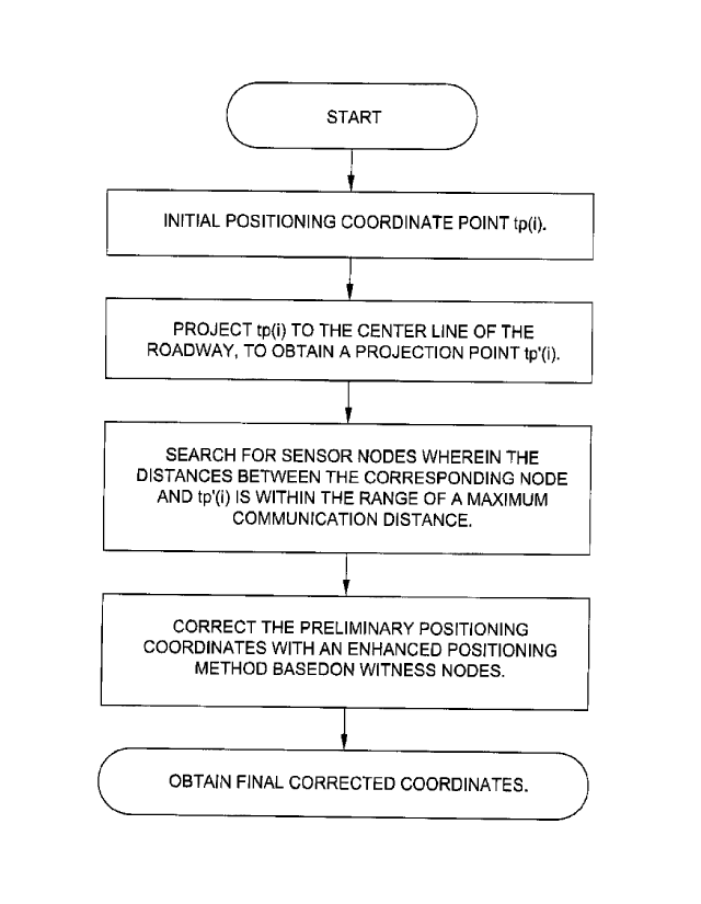
Fig. 1 is a flow chart of the entire algorithm in the present invention;
Fig. 2 is a schematic diagram of the enhanced algorithm in the present
invention, when the
nearest witness node and the second nearest witness node finally can find and
can't find the
moving target;
Fig. 3 is a schematic diagram of the enhanced algorithm in the present
invention, when the
nearest witness node and the second nearest witness node finally can't find
and can find the
moving target;
Fig. 4 is a partial schematic diagram of the enhanced algorithm in the present
invention, in the
case that both witness nodes can finally find the moving target.
Embodiments
Hereunder an example of the present invention will be further described with
reference to the
accompanying drawings.
The enhanced positioning method for a moving target in a mine shaft based on
witness nodes
under Internet of Things architecture comprises: positioning a moving target
with an existing
mine shaft positioning system when the moving target moves in a roadway, and
obtaining an
initial positioning coordinate point tp(i); then, projecting the initial
positioning coordinate point
tp(i) to the center line of the roadway, so as to obtain a projection point
tp'(i), and utilizing an
Internet of Things management and control platform to search for sensor nodes
wherein the
6
CA 02958759 2017-02-15
distance bwtween corresponding sensor node and the projection point tp'(i) is
within the range
of a maximum communication distance; finally, using the sensor nodes as
witness nodes to
correct the obtained initial positioning coordinate point with an enhanced
positioning method
based on witness nodes to improve the positioning accuracy of the moving
target; specifically,
the steps are as follows:
(1) obtaining an initial positioning coordinate point tp(i) of a moving
target with a mine shaft
positioning algorithm when the moving target moves in a roadway and
communicates with
the mine shaft positioning system;
(2) projecting the initial positioning coordinate point tp(i) to the center
line of the roadway, so
as to obtain a projection point tp'(i);
(3) obtaining a maximum search radius d,,, of sensor node, when a maximum
transmitting
power P. of the sensor node is known;
(4) utilizing an Internet of Things management and control platform to
search for sensor nodes
wherein the distances between the corresponding sensor node and the projection
point is
within the range of a maximum communication distance (i.e., the maximum search
radius
and logging the number n of the sensor nodes and the coordinates of the sensor
nodes;
(5) using the sensor nodes as witness nodes to correct the obtained initial
positioning
coordinate point with an enhanced positioning method based on witness nodes,
to obtain a
final positioning coordinate point rp(i).
The entire process of the algorithm is shown in Fig. I.
The enhanced positioning method based on witness node comprises the following
steps:
step 1: judging which of the following conditions is met by the number n of
sensor nodes;
(I) if n=0, it indicates there is no witness node near the moving target,
and it is unable to
correct the initial positioning coordinate point tp(i); in that case, it is
unnecessary to carry
out the processing in the following steps; instead, the result is outputted
directly, i.e., tp(i)
is the final positioning coordinate point rp(i);
(2) if n>=1, the step I is handled in the following two cases:
a. if n=1, it indicates there is one witness node near the moving target; in
that case, a base station
that is at the nearest distance to the moving target in the Internet of Things
management and
control platform is used as another witness node, the two witness nodes are
denoted as sp,(1) and
spi(2) respectively, and their coordinates are (x,i, yil) and (x1.2, y12);
7
CA 02958759 2017-02-15
b. if n>=2, two sensor nodes that are at the nearest distances to tp'(i) are
used as witness nodes,
the two witness nodes are denoted as spi(1) and sp,(2) respectively, and their
coordinates are (xii,
y,i) and (xi2, yo) respectively;
step 2: calculating the distances d,(1) and d,(2) from the projection point
tpt(i) to the witness
nodes spi(1) and sp,(2) respectively; calculating a line // passing through
spi(i) and spi(2):
V -y.,
x -x
11 s2 , a line
12 passing through spi(1) and parallel to the center line of the
roadway, and a line 13 passing through sp1(2) and parallel to the center line
of the roadway;
setting the positioning accuracy range of the moving target to ro meter;
step 3: adjusting the transmitting power of the witness nodes, determining a
search area in radius
did), searching for the moving target, and handling in either of the following
cases depending on
whether the moving target is found:
case 1: if the witness nodes find the moving target within the search area in
radius d,O, j=1, 2,
adjusting the transmitting power so that the search radius is inwardly
compressed by ro m in
each time, i.e., iteratively searching for the moving target in radius (diN -
countX ro), till the
witness nodes can't find the moving target or a condition (da m X ro < ro) is
met in the mil'
search cycle, where, count=1, m; cl(1)
> inX ro; m is the total number of iteration search
cycles:
a. if the witness nodes can't find the moving target in the mth search cycle,
it indicates that the
moving target is within a range constituted by concentric annuli centering on
spa, i.e., within a
range constituted by annuli (I) and (2); in that case, the following formula
(1) is met:
+ ( v ¨ v (11) r = (x¨x,2)2 + (y ¨ N)' (2)
(X¨ x 4)2 + v ¨ y )2 :5-R2 (I)
where, R=diN -(m-1) X ro, r = 4.0 - rn X ro;
b. if the criterion (d,0) - m X ro < ro) is met, it indicates that the moving
target is within a range
of a minimum circle in radius (d,(i) - m X ro) centering on spi0); in that
case, the following
formula (2) is met:
(x x,) )2 + y ¨ )2 5 r2 ( 2 )
where, r d,02- mXro;
case 2: if the witness nodes can't find the moving target within the search
area in radius d,a),
8
CA 02958759 2017-02-15
adjusting the transmitting power so that the search radius is outwardly
expanded by ro meter in
each time, i.e., iteratively searching for the moving target in radius (40 +
countXr0), till the
witness nodes finds the moving target in the mth search cycle or no witness
node is found within
the range dm, where, count=?, m; (d,C)
+ m X ro) < ?I is the total number of iteration
search cycles:
a. if the witness nodes finds the moving target in the Mt h search cycle, it
indicates that the
moving target is within a range constituted by concentric annuli centering on
spa, i.e., within a
range constituted by annuli (3) and (4); in that case, the following formula
(3) is met:
R'2 = ( x ¨ xi/ )2 ( y ¨ yt, )2 (4) r'2 = (x )2 + ( y )2 (4)
r'' 5(x¨x)2 +(y¨ )2 R (3)
where, R'=d,a) + m X 7.0, r'=c11(j) + (m-1) X ro;
b. if no witness node is found within the range dm, it indicates the moving
target can't be found
within the maximum expansion range; in that case, the following formula (4) is
met:
(d,(j)+mxrp) (4)
step 4: correcting the initial positioning point tp(i) based on the two
witness nodes:
after iterative search is carried out for sp,(1) and sp1(2), analyzing the
types of sp,(1) and sp1(2)
directed to the step 3 and correcting the initial positioning point;
(1) if both sp,(1) and sp,(2) belong to the type b in the case 2, the
witness nodes can't play a
role, and tp(i) is the final positioning coordinate point rp(i);
(2) if one of sp,(1) and sp,(2) belongs to the type a in the case 1 and the
other of sp,(1) and
sp,(2) belongs to the type b in the case 2, then, only one witness node can
find the target
node and plays the role of "witness" truly, in the case that the moving target
is within the
range of double annuli centering on sp1(1) and outside of a circle centering
on sp,(2) in
radius d,õõõ, if there is an intersection region at a side, the area scope of
the moving target
can be determined, and the line 12 has two intersecting points with the
boundary of the area
of the moving target; in that case, a middle point rp'(i) between the two
intersecting points
is calculated; otherwise, there are two intersection areas; in that case, a
shadow area that is
closer to the initial positioning value is selected as the area of the moving
target, and rp'(i)
is obtained in the same way;
if the moving target is within double annuli centering on sp,(2) and outside
of a circle centering
on sp1(1) in radius dõ,,õ rp'(i) can be calculated in the same way;
9
CA 02958759 2017-02-15
(3) in other cases except the above-mentioned cases, the moving target is
within an intersection
area centering on sp,(1) and sp,(2), and the line ii has two intersecting
points with the boundary
of the intersection area; in that case, calculating a middle point rp'(i)
between the two
intersecting points; if there is no intersection between the search result
areas of sp,(1) and sp,(2),
an inner arc in a result annular area at the right side of the left witness
node and an inner arc in a
result annular area at the left side of the right witness node are taken, the
line ii has one
intersecting point with the two arcs respectively, and a middle point rp'(i)
between the two
intersecting points is calculated;
step 5: projecting rp'(i) to the center line of the roadway; thus, the
projection point on the center
line is the final positioning coordinate point rp(i), as shown in Figs. 2, 3,
4.