Note: Descriptions are shown in the official language in which they were submitted.
CA 02960470 2017-03-07
HH-1530
PCT/JP2015/080410
DESCRIPTION
TITLE OF THE INVENTION: MAP GENERATION DEVICE
TECHNICAL FIELD
[0001]
The present invention relates to a map generation device
generating travelable map information used for traveling of
work machines.
BACKGROUND ART
[0002]
For the mining operation of mines and the like, there is
a need for the autonomous travel technology to use unmanned
machines to carry out mining work with the aim of improving the
safety and reducing the costs. At a mining site, after a work
machine such as a hydraulic excavator or the like excavates
minerals and/or a topsoil layer, the excavated minerals and/or
topsoil layer must be hauled to the outside of the mining site.
Such haulage work is carried out by a work machine such as a
dump truck and the like, which has a body (vessel) capable of
carrying minerals and/or topsoil layer and having a relatively
high maximum load capacity.
[0003]
As one of conventional techniques in the autonomous
travel technology using a work machine of this type such as a
dump truck, for example, an autonomous travel system is
proposed to implement travel control of a vehicle for
autonomous traveling without an onboard operator on the basis
of own-vehicle position information calculated by a positioning
1
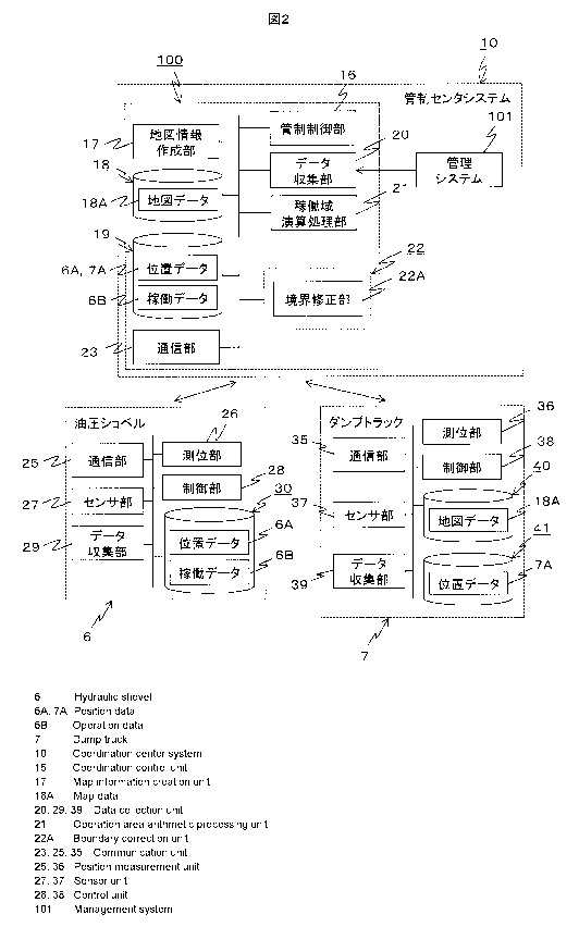
CA 02960470 2017-03-07
HH-1550
PCT/JP2015/080410
device, such as using GPS (Global Positioning System) or the
like, mounted on the work machine.
[0004]
In the autonomous travel system, the own-vehicle position
calculated by the positioning device is transmitted to a
control center over wireless communications. The control
center generates a transportation course from a loading site at
which a work machine such as a hydraulic excavator or the like
loads minerals and/or topsoil layer, to a dumping site at which
a work machine such as a dump truck or the like dumps the
minerals and/or topsoil layer, and generates a target route in
a working site such as a loading site, dumping site and/or the
like. Then, the control center transmits target route
information as data indicating the target route to the work
machine such as a dump truck or the like.
[0005]
For the transportation course, the target route of the
work machine is generated based on mine map data generated from
trajectory information of the work machine, such as a dump
truck or the like, previously obtained by the positioning
device. Also, for the working site, a target route is
generated, for example, from an entrance to a loading point to
the loading point set near the work machine such as a hydraulic
excavator or the like.
[0006]
In contrast, the map data includes boundary information
indicating a boundary. The boundary is generated by being
extracted from a travel trajectory of the work machine, such as
a dump truck or the like, the travel trajectory being included
in the own-vehicle position information calculated by the
2
CA 02960470 2017-03-07
HH-1530
PCT/JP2015/080410
positioning device, and the boundary defines a travelable area
capable of being travelled by a work machine and a non-
travelable area incapable of being travelled by a work machine.
The boundary information is used to prevent interference
between a boundary line in map data and a target route when the
target route for the transportation course and the working site
as described above are generated. Thus, the map data is
required to be updated frequently as the work process proceeds.
[0007]
To address this, the following patent literature 1 is
known as one of conventional techniques to update map data.
The patent literature 1 discloses "an unmanned-vehicle guidance
device that guides an unmanned vehicle to travel along a guide
course on the basis of a travel position of the unmanned
vehicle measured by travel position measuring means and course
data defining the guide course for the unmanned vehicle, the
unmanned-vehicle guidance device comprising: means that inputs
data on boundary lines of a course area; means that generates
course data; means that infers interference between the
unmanned vehicle and the boundary lines of the course area when
the unmanned vehicle is traveled along the guide course defined
by the generated course data; course data changing means that
changes the course data if the interference is inferred;
recognizing means that recognizes which of all segments of the
boundary lines of the course area changes in shape of the
boundary line; and course-area boundary-line updating means
that updates data on the boundary lines of the course area in
respect of only the segment with the changed shape of the
boundary line of all the segments of the boundary lines of the
course area, in which the recognizing means includes a work
3
CA 02960470 2017-03-07
HH-1530
PCT/JP2015/080410
machine moving the course area, moving position measuring means
that measures a moving position of the work machine, and means
that specifies the segment with the changed shape of the
boundary lines of all the segments of the boundary lines of the
course area on the basis of the moving position of the work
machine."
CITATION LIST
PATENT LITERATURE
[0008]
Patent literature 1: JP-A No. 2010-134961
SUMMARY OF INVENTION
TECHNICAL PROBLEM
[0009]
The unmanned-vehicle guidance device disclosed in the
above patent literature 1 uses the position information of the
work machine to specify the segment with the changed shape of
the boundary in the travelable map information indicating the
area capable of being travelled by a work machine. However, an
actual boundary of a working site such as a loading site, a
dumping site and/or the like is varied with not only the moving
position of the work machine but also the operational status of
the work machine, but the unmanned-vehicle guidance device of
the conventional techniques take only the moving position of
the work machine into account. Thus, the travelable map
information updated by the unmanned-vehicle guidance device of
the conventional techniques may possibly not reflect properly a
boundary of a working site.
[0010]
4
CA 02960470 2017-03-07
HH-1530
PCT/JP2015/080410
For example, it is possible that a dump truck may be
loaded with or may dump minerals and/or topsoil layer within
the boundary of a working site in the travelable map
information, whereas a loading machine may collect minerals
and/or topsoil layer from a place other than the travelable
area for the dump truck located across the boundary of the
working site. Therefore, if the full position information of
the loading machine obtained from a positioning device such as
using GPS or the like is used to generate a boundary of a
working site for the travelable map information as done in the
unmanned-vehicle guidance device of the conventional techniques,
position information about an area capable of being travelled
by the dump truck may be included in the travelable map
information as a travelable area. This causes a concern about
a reduction in accuracy of the extraction of a boundary of a
working site for the travelable map information.
[0011]
Further, even if the positioning device such as using GPS
or the like acquires position information while a dump truck is
traveling, it is possible that the dump truck does not travel
around the boundary. Therefore, if the position information
while the dump truck is traveling is taken into account, this
unnecessary position information may have effect on generation
of boundaries of a working site for the travelable map
information. In consequence of this, similarly to above, there
is a concern about a reduction in accuracy of the extraction of
boundaries of a working site for the travelable map information.
[0012]
The present invention has been made in light of such
circumstances in the conventional techniques, and it is an
object of the present invention to provide a map generation
device capable of improving the accuracy of extraction of a
boundary of a working site in travelable map information.
SOLUTION TO PROBLEM
[0013]
Certain exemplary embodiments can provide a map generation
device generating travelable map information representing a
travelable area of a working site for autonomous dump trucks,
the travelable map information being defined as inside a
boundary of the travelable area of the working site, the map
generation device comprising: a controller including a CPU; a
communication device in operable wireless communication with the
autonomous dump trucks and a non-autonomous hydraulic excavator;
and a storage device, wherein the storage device stores
statements and instructions that when executed by the CPU cause
the CPU to: store the travelable map information in the storage
device and retrieve the travelable map information from the
storage device; receive and transmit, between the controller
through the communication device and the autonomous dump trucks,
position information measured by positioning devices equipped on
the autonomous dump trucks; wirelessly communicate, by the
communication device, the travelable map information stored in
the storage device with the autonomous dump trucks; receive, at
the communication device from the non-autonomous hydraulic
excavator, position information measured by positioning devices
equipped on the non-autonomous hydraulic excavator and
operational information measured by operational status devices
equipped on the non-autonomous hydraulic excavator as the non-
autonomous hydraulic excavator travels in the working site;
calculate an operational range of the non-autonomous hydraulic
6
CA 2960470 2019-08-20
excavator on the basis of the position information and the
operational information for the non-autonomous hydraulic
excavator; calculate a center of gravity of the non-autonomous
hydraulic excavator as a reference point of the operational
range of the non-autonomous hydraulic excavator on the basis of
the position information for the non-autonomous hydraulic
excavator; verify the operational range of the non-autonomous
hydraulic excavator against the travelable map information for
the autonomous dump trucks by determining that the non-
autonomous hydraulic excavator is within the boundary of the
working site when a distance between the center of gravity of
the non-autonomous hydraulic excavator and a position closest to
the center of gravity of the non-autonomous hydraulic excavator
on the boundary is greater than a predetermined threshold;
correct boundary information of the working site in the
travelable map information for the autonomous dump trucks to
decrease the travelable area of the working site for the
autonomous dump trucks when the center of gravity of the non-
autonomous hydraulic excavator is determined in the verifying of
the operational range of the non-autonomous hydraulic excavator
to be located within the boundary; correct the boundary
information of the working site in the travelable map
information for the autonomous dump trucks to increase the
travelable area of the working site for the autonomous dump
trucks when the center of gravity of the non-autonomous
hydraulic excavator is determined in the verifying of the
operational range of the non-autonomous hydraulic excavator to
be either located on the boundary or outside the boundary;
update the travelable map information for the autonomous dump
trucks with the corrected boundary information; and transmit, by
the communication device, the updated travelable map information
6a
CA 2960470 2019-08-20
to the autonomous dump trucks for controlling operation and
travel of the autonomous dump trucks.
ADVANTAGEOUS EFFECTS OF INVENTION
[0014]
6b
CA 2960470 2019-08-20
CA 02960470 2017-03-07
HH-1530
PCT/JP2015/080410
With the map generation device according to the present
invention, an improvement in accuracy of extraction of a
boundary of a working site for the travelable map information
is enabled. The above-recited and other problems,
configuration and advantages will be apparent from the
following description of embodiments.
BRIEF DESCRIPTION OF DRAWINGS
[0015]
[Fig. 1] Fig. 1 is a diagram illustrating the overall
layout of a mine in which a map generation device in accordance
with a first embodiment of the present invention is used.
[Fig. 21 Fig. 2 is a function block diagram illustrating
the configurations of a control center system, a hydraulic
excavator and a dump truck in accordance with the first
embodiment of the present invention.
[Fig. 3] Fig. 3 is a diagram illustrating an example
configuration of map data stored in a map information storage
unit in accordance with the first embodiment of the present
invention.
[Fig. 4] Fig. 4 is tables for illustrating an example
configuration of each set of data accumulated in a work machine
information accumulation unit in accordance with the first
embodiment of the present invention, in which Fig. 4A is a
table showing position data of the hydraulic excavator and Fig.
4B is a table showing operational data of the hydraulic
excavator.
[Fig. 5] Fig. 5 is a flowchart showing a flow of
generation processing of map data performed by a map
information generation unit in accordance with the first
7
CA 02960470 2017-03-07
HH-1530
PCT/JP2015/080410
= embodiment of the present invention.
[Fig. 6] Fig. 6 is a sequence diagram showing a flow of
operation of each of the control center system, the hydraulic
excavator and the dump truck in accordance with the first
embodiment of the present invention.
[Fig. 7] Fig. 7 is a flowchart showing a flow of
arithmetic processing for an operational range of the hydraulic
excavator performed by an operational range arithmetic
processing unit in accordance with the first embodiment of the
present invention.
[Fig. 8] Fig. 8 is a diagram illustrating a process of
arithmetic performed for the operational range of the hydraulic
excavator by the operational range arithmetic processing unit
in accordance with the first embodiment of the present
invention.
[Fig. 9] Fig. 9 is a flowchart showing a flow of update
processing perfolmed on map data by map information update unit
in accordance with the first embodiment of the present
invention.
[Fig. 10] Fig. 10 is diagrams showing map data after the
update processing by the map information update unit in
accordance with the first embodiment of the present invention,
in which Fig. 10A is the diagram when the area of a loading
site in the map data is decreased, and Fig. 10B is the diagram
when the area of the loading site in the map data is increased.
[Fig. 11] Fig. 11 is a sequence diagram showing a flow of
operation of each of a control center system, a hydraulic
excavator and a dump truck in accordance with a second
embodiment of the present invention.
[Fig. 12] Fig. 12 is a flowchart showing a flow of
8
CA 02960470 2017-03-07
HH-1530
PCT/JP2015/080410
arithmetic processing for operational ranges of the hydraulic
excavator and the dump truck performed by an operational range
arithmetic processing unit in accordance with the second
embodiment of the present invention.
[Fig. 13] Fig. 13 is a diagram illustrating a process of
arithmetic performed for the operational ranges of the
hydraulic excavator and the dump truck by the operational range
arithmetic processing unit in accordance with the second
embodiment of the present invention.
[Fig. 14] Fig. 14 is a function block diagram
illustrating the configurations of a control center system, a
hydraulic excavator and a dump truck in accordance with a third
embodiment of the present invention.
[Fig. 15] Fig. 15 is a diagram illustrating an example
configuration of operational data of the dump truck accumulated
in a work machine information accumulation unit in accordance
with the third embodiment of the present invention.
[Fig. 16] Fig. 16 is a sequence diagram showing the flow
of each operation of the control center system and the dump
truck in accordance with the third embodiment of the present
invention.
[Fig. 17] Fig. 17 is a flowchart showing the flow of
arithmetic processing for an operational range of the dump
truck performed by an operational range arithmetic processing
unit in accordance with the third embodiment of the present
invention.
[Fig. 18] Fig. 18 is a diagram illustrating the process
of arithmetic performed for Lhe operational range of the dump
truck by the operational range arithmetic processing unit in
accordance with the third embodiment of the present invention.
9
CA 02960470 2017-03-07
HH-1530
PCT/JP2015/080410
DESCRIPTION OF EMBODIMENTS
[0016]
Embodiments of a map generation device in accordance with
the present invention will be described below with reference to
the accompanying drawings. In the following embodiments, a
description is divided into a plurality of sections or
embodiments if necessary for the sake of convenience. In the
embodiments, where reference is made to a specific number of
elements and/or the like (including numbers, numeric values,
amounts, ranges, etc.), the specific number is not limited
thereto, and any number greater or less than the specific
number may be used unless otherwise specified, unless the
specific number is limited thereto clearly in theory, and the
like. It should be noted that in the following embodiment the
element(s) (including a processing step(s) etc.) is not
necessarily essential unless otherwise specified, unless the
element(s) is considered to be essential clearly in theory, and
the like.
[0017]
Further, configurations, functions, processing units,
processing means and the like in the following embodiments may
each be implemented in part or in whole as, for example, an
integrated circuit or any other hardware. Further,
configurations, functions, processing units, processing means
and the like, which will be described later, may be implemented
as a program executed on a computer, that is, may also be
implemented as software. Information regarding programs,
tables, files and/or the like which implement each
configuration, function, processing unit, processing means
CA 02960470 2017-03-07
HH-1530
PCT/JP2015/080410
and/or the like may be stored in a storage device such as
memory, hard disks, SSD (Solid State Drive) and/or the like,
and/or on a storage medium such as IC cards, SD cards, DVDs
and/or the like.
[0018]
Embodiments of a map generation device in accordance with
the present invention will now be described in detail with
reference to the accompanying drawings. It should be noted
that in all the drawings used to describe the embodiments,
members having the same function are denoted by the same or
related reference signs, and a repetitive description is
omitted. Further, in the following embodiments, a description
of the same or similar component is not repeated in principle
except when necessary.
[0019]
First embodiment
Regarding a map generation device in accordance with a
first embodiment of the present invention, work machines
include haulage vehicles such as dump trucks hauling a load and
the like, and loading machines such as hydraulic excavators,
wheel loaders and the like to load the haulage vehicles with
the load, by way of example. A feature of the map generation
device is a configuration for generating travelable map
information indicating an area capable of being travelled by
the haulage vehicle.
[0020]
The map generation device 100 in accordance with the
first embodiment of the preset invention is used, for example,
in a mine illustrated in Fig. 1. The mine includes at least a
loading site 1 and a dumping site 2 which are working sites,
11
CA 02960470 2017-03-07
HH-1530
PCT/JP2015/080410
and a machine parking site 3, as well as transport courses 4
connecting the loading site 1, the dumping site 2 and the
machine parking site 3 to each other, and a radio base station
located distance from the loading site 1, the dumping site 2,
the machine parking site 3 and the transport courses 4. Two
travel paths of the traveling directions opposite to each other
are formed in each transport course 4.
[0021]
The loading site 1 is a place where a loading machine 6
performs a loading work at a loading position to load minerals
and/or topsoil layer on to a haulage vehicle 7. The loading
machine 6 is equipped with, for example, a huge hydraulic
excavator (hereinafter denoted by the same reference sign as
that of the loading machine). The hydraulic excavator 6 is
equipped with: a travel base; a revolving upperstructure
mounted rotatably above the travel base through a swing frame;
a front working assembly placed forward of the revolving
upperstructure; a cab placed in the front of the revolving
upperstructure for an operator on board; and an antenna placed
on the top of the cab for connection to a wireless
communication channel 8.
[0022]
The front working assembly includes: a boom mounted in an
elevatable manner with respect to the revolving upperstructure;
an arm attached rotatably at the leading end of the boom; and a
bucket attached rotatably at the leading end of the arm. The
boom, the arm and the bucket are operated by the operator in
the cab in such a manner as to rotate in the vertical direction
in order to excavate minerals and/or topsoil layer and load
them on to the haulage vehicle 7. Note that the loading
12
CA 02960470 2017-03-07
HH-1530
PCT/JP2015/080410
machine is not limited to include the above-described hydraulic
excavator 6, and may include a work machine such as a wheel
loader or the like. Also, a description will be given later of
a specific configuration showing the function of the hydraulic
excavator 6 for implementing the map generation device in
accordance with the first embodiment of the present invention.
[0023]
Further, the dump truck 7 includes an antenna installed
on an upper forward portion of the vehicle for connection to
the wireless communication channel 8. Also, a description will
be given later of a specific configuration showing the function
of the dump truck 7 for implementing the map generation device
in accordance with the first embodiment of the present
invention.
[0024]
The dumping site 2 is a place where the dump truck 7
dumps the transported minerals and/or topsoil layer. The
machine parking site 3 is a place where the operators are
replaced and the dump truck 7 is parked. A control center 9 in
which the operators wait is provide within the machine parking
site 3. In the control center 9, a control center system 10
(see Fig. 2) is installed to be operated by the operator to
control the autonomous traveling of the dump truck 7. The
control center system 10 transmits, for example, operational
instructions to the hydraulic excavator 6 and the dump truck 7
via a later-described data collection unit 20 (see Fig. 2) to
operate the hydraulic excavator 6 and the dump truck 7,
respectively. The control center system 10 has a management
system 101 to manage the operational status of the hydraulic
excavator 6.
13
CA 02960470 2017-03-07
HH-1530
PCT/JP2015/080410
[0025]
The loading site 1, the dumping site 2 and the machine
6
parking site 3 in such a mine have respective boundaries 1A, 2A,
3A defining a travelable area and a non-travelable area for the
dump truck 7. Then, the hydraulic excavator 6 performs the
excavation work and the loading work in the vicinity of the
boundary 1A of the loading site 1. The dump truck 7 travels
within the boundaries 1A, 2A, 3A of the loading site 1, the
dumping site 2 and the machine parking site 3 and along the
transport course 4 and performs the dumping work within the
boundary 2A of the dumping site 2.
[0026]
Kinds of the dumping work includes a work for the dump
truck 7 dumping minerals and/or topsoil layer toward the
outside of the boundary 2A, a work for the dump truck 7 dumping
minerals and/or topsoil layer to a predetermined position
within the boundary 2A, and a work for the dump truck 7 dumping
minerals and/or topsoil layer to change from one dumping
position to another within the boundary 2A which is also called
"paddock dumping".
[0027]
The radio base station 5 is a base station to provide
intercommunication connection between the hydraulic excavator 6,
the dump truck 7 and the control center system 10 over the
wireless communication channel 8. Radio waves in wireless
communication from the hydraulic excavator 6, the dump truck 7
or the control center system 10 pass through the radio base
station 5, thereby making reception/transmission of various
kinds of information between the hydraulic excavator 6, the
dump truck 7 and the control center system 10.
14
CA 02960470 2017-03-07
HH-1530
PCT/JP2015/080410
[0028]
Further, in addition to the hydraulic excavator 6 and the
dump truck 7, a work vehicle 11 and a light vehicle 12 for
navigation measurement are in operation in the mine. The work
vehicle 11 monitors whether or not the works are conducted with
safety in the loading site 1 and the dumping site 2, and also
performs a work of removing the dumped minerals and topsoil
layer, and the like. The light vehicle 12 obtains and collects
trajectory information which is to serve as the origin of
travelable map information (hereinafter referred to as the "map
data" for convenience sake) required for autonomous traveling
of the dump truck 7.
[0029]
The light vehicle 12 receives positioning radio waves
from a GPS navigation satellite, not shown, to obtain a
position of the vehicle's own (e.g., coordinate values).
[0030]
The light vehicle 12 is equipped with, for example, a GPS
receiver (not shown) mounted at a predetermined position of the
vehicle, and saves trajectory information including an
acquisition time and an own-vehicle position obtained through
the GPS receiver as record information. Then, the light
vehicle 12 transmits the saved trajectory information to the
control center system 10 at predetermined time intervals over
the wireless communication channel 8.
[0031]
The following description is given, in order with
reference to Fig. 2, of each configuration showing functions of
the control center system 10, hydraulic excavator 6 and the
dump truck 7 for implementing the map generation device in
CA 02960470 2017-03-07
HH-1530
PCT/JP2015/080410
accordance with the first embodiment of the present invention.
[0032]
As shown in Fig. 2, the control center system 10 is
equipped with a control-center control unit 16, map information
generation unit 17, map information storage unit 18, work
machine information accumulation unit 19, data collection unit
20, operational range arithmetic processing unit 21, map
information update unit 22 and a communication unit 23, and the
control center system 10 has a function as the map generation
device 100 implemented by associating these units 16 to 23 with
each other.
[0033]
The control-center control unit 16 controls the operation
of each element of the control center system 10, and is
configured using, in addition to an arithmetic and control
device such as CPU (Central Processing Unit) and/or the like: a
storage device such as ROM (Read Only Memory), HDD (Hard Disk
Drive) and/or the like to store programs executed by the
control center system 10; and hardware including RAM (Random
Access Memory) providing a workspace when CPU executes the
programs.
[0034]
The control-center control unit 16 also
receives/transmits required information from/to later-described
control units 28, 38 of respective the hydraulic excavator 6
and the dump truck 7 in order to control the operations of the
hydraulic excavator 6 and the dump truck 7 on the basis of map
data for controlling dispatch management and autonomous
travelling of the dump truck 7.
[0035]
16
CA 02960470 2017-03-07
HH-1530
PCT/JP2015/080410
The map information generation unit 17 generates map data
18A on the basis of the trajectory information collected by the
light vehicle 12 and the dump truck 7. The map information
storage unit 18 is configured with a device permanently storing
information such as HDD and/or the like, and stores the map
data 18A generated mainly by the map information generation
unit 17. Incidentally, the processing of the map information
generation unit 17 to generate the map data 181\ will be
described later in detail.
[0036]
As shown in Fig. 3, the map data 18A includes boundaries
18a to 18c on the map corresponding to the respective
boundaries 1A to 3A of the loading site 1, the dumping site 2
and the machine parking site 3, and a transport course 18d on
the map corresponding to the transport course 4. The transport
course 18d of the map data 18A includes position information
(coordinate values) on each of nodes 18d1 defining the travel
path on the transport course 4, and links 18d2 each connecting
adjacent nodes 18d1 to each other. Note that the map data 18A
may include mine topographic information and absolute
coordinates of each node 18d1 (real three-dimensional
coordinates calculated based on positioning radio waves).
Incidentally, the nodes 18d1 and the links 18d2 are assigned
identification information uniquely identifying each of the
nodes 18d1 and links 18d2.
[0037]
In Fig. 2, the work machine information accumulation unit
19 is configured with a device permanently storing information
such as HDD and/or the like, and accumulates: position
information indicating a position of the hydraulic excavator 6
17
CA 02960470 2017-03-07
HH-1530
PCT/J2015/0804l0
collected by the data collection unit 20 (hereinafter referred
to as the "position data" for convenience sake) 6A operational
4
information indicating an operational status of the hydraulic
excavator 6 (hereinafter referred to as the "operational data"
for convenience sake) 6B; and position information indicating a
position of the dump truck 7 (hereinafter referred to as the
"position data" for convenience sake) 7A.
[0038]
For example, as shown in Fig. 4A, the position data 6A of
the hydraulic excavator 6 includes: an acquisition time 6A1; a
work machine ID 6A2 pre-assigned to each hydraulic excavator 6
in the mine for identification of the hydraulic excavator 6;
and position coordinates 6A3 representing the position of the
hydraulic excavator 6 at the acquisition time 6A1 by use of
latitude X, longitude Y and altitude Z coordinates. Note that
the configuration of position data 7A of the dump truck 7 is
similar to the configuration of the above position data 6A of
the hydraulic excavator 6, and a repetitive description is
omitted.
[0039]
For example, as shown in Fig. 4B, the operational data 6B
of the hydraulic excavator 6 includes: an acquisition time 6B1;
a work machine ID 6B2 pre-assigned to each hydraulic excavator
6 in the mine for identification of the hydraulic excavator 6;
and operational status 6B3 that is a column for a record of the
status of a work performed by the hydraulic excavator 6 at the
acquisition time 681. Thus, the position data 6A and the
operational data 6B of the hydraulic excavator 6 are associated
with each other in terms of the acquisition times 6A1, 6B1.
[0040]
18
CA 02960470 2017-03-07
HH-1530
PCT/JP2015/080410
= The data collection unit 20 collects the position data 6A
and the operational data 6B of the hydraulic excavator 6 and
the position data 7A of the dump truck 7 from the information
received via the communication unit 23 by the control-center
control unit 16. The operational range arithmetic processing
unit 21 functions as an operational range arithmetic unit that
calculates an operational range of the hydraulic excavator 6 on
the basis of the position data 6A and the operational data 6B
of the hydraulic excavator 6 out of the data 6A, 6B and 7A
accumulated in the work machine information accumulation unit
19, and performs predetermined processing until the map
information update unit 22 initiates the update processing on
the map data 18A.
[0041]
The map information update unit 22 verifies the
operational range of the hydraulic excavator 6 calculated by
the operational range arithmetic processing unit 21 against the
map data 18A stored in the map information storage unit 18 in
order to correct the boundary 18a of the loading site 1 in the
map data 18A, thus updating the map data 18A.
[0042]
Specifically, the map information update unit 22 includes
a boundary correction unit 22A. The boundary correction unit
22A corrects the boundary 18a of the loading site 1 in the map
data 18A such that the area of the loading site 1 is decreased
when the operational range of the hydraulic excavator 6
calculated by the operational range arithmetic processing unit
21 is located within the boundary 18a of the loading site 1 in
the map data 18A, whereas, when the operational range of the
hydraulic excavator 6 calculated by the operational range
19
CA 02960470 2017-03-07
HH-1530
PCT/JP2015/080410
arithmetic processing unit 21 is located on the boundary 18a
and without the boundary 18a of the loading site 1 in the map
data 18A, the boundary correction unit 22A corrects the
boundary 18a of the loading site 1 in the map data 18A such
that the area of the loading site 1 is increased.
[0043]
The communication unit 23 establishes intercommunication
connection between the outside-located dump truck 7 and the
control center system 10 over the wireless communication
channel 8.
[0044]
The hydraulic excavator 6 is equipped with a
communication unit 25, a positioning unit 26, a sensor unit 27,
a control unit 28, a data collection unit 29, and a work
machine information accumulation unit 30. Note that the
communication unit 25 is similar to the above-described
communication unit 23 of the control center system 10, and a
repetitive description is omitted.
[0045]
The positioning unit 26 receives positioning radio waves
from a CPS navigation satellite, not shown, to obtain its own
position. In the first embodiment according to the present
invention, the positioning unit 26 obtains, for example, a
position of the bucket as the position of the hydraulic
excavator 6.
[0046]
Specifically, the positioning unit 26 includes a GPS
receiver installed in a predetermined position of the vehicle,
and an attitude detection unit that detects the attitude of the
front working assembly, which are not shown. The positioning
CA 02960470 2017-03-07
HH-1530
PCT/JP2015/080410
unit 26 calculates the position of the bucket on the basis of
the position obtained by the GPS receiver, the attitude
detected by the attitude detection unit and the dimension
information of the front working assembly. Note that the
attitude detection unit is configured with, for example, an
angle sensor detecting each of angles of the boom, the arm and
the bucket. Also, arithmetic for the position of the bucket by
the positioning unit 26 is not limited to the above, and may be
performed by installing the GPS receiver directly to the bucket,
by way of example.
[0047]
The sensor unit 27 is configured with, for example, a
sensor detecting obstruction around the vehicle such as a
millimeter-wave radar, a camera and/or the like. The detection
result of the sensor is displayed on a monitor (not shown) in
the cab. Thus, the operator in the cab can easily determine
the obstruction around the vehicle by checking the display on
the monitor.
[0048]
The control unit 28 controls the operation of each of
elements of the hydraulic excavator 6, and is configured using,
in addition to an arithmetic and control device such as CPU
and/or the like: a storage device such as ROM, HDD and/or the
like to store programs executed by the hydraulic excavator 6;
and hardware including RAM providing a workspace when CPU
executes the programs.
[0049]
The data collection unit 29 collects, for example,
positions of the bucket obtained by the positioning unit 26 at
predetermined time intervals as the position data 6A, and also
21
CA 02960470 2017-03-07
HH-1530
PCT/JP2015/080410
collects the operational data 6B of the hydraulic excavator 6.
As concrete examples of the collection of the operational data
6B, the data collection unit 29 records information on
instructions of the operator to the hydraulic excavator 6 in
order to collect information on a status in which the loading
position of the hydraulic excavator 6 is set (see Fig. 4B), a
status in which the loading work of the hydraulic excavator 6
is completed (see Fig. 4B), and the like.
[0050]
Also, the data collection unit 29 records the detection
result of the attitude detection unit of the positioning unit
26 that monitors the operating conditions of the hydraulic
excavator 6, in order to collect information on a status in
which the revolving upperstructure is swinging (see Fig. 4B), a
status in which the bucket is being rotated upward (see Fig.
4B), and the like. Note that the collection of the operational
data 6B by the data collection unit 29 is not limited to the
above, and may be performed by recording information on
operation performed by the operator.
[0051]
The work machine information accumulation unit 30 is
configured with a device permanently storing information such
as HDD and/or the like, and accumulates the position data 6A
and the operational data 6B collected by the data collection
unit 29. Further, the position data 6A accumulated in the work
machine information accumulation unit 30 is transmitted at
predetermined time intervals to the control center system 10
through the communication unit 25.
[0052]
The dump truck 7 is equipped with a communication unit 35,
22
CA 02960470 2017-03-07
HH-1530
PCT/JP2015/080410
a positioning unit 36, a sensor unit 37, a control unit 38, a
data collection unit 39, a map information storage unit 40 and
a work machine information accumulation unit 41. Note that the
communication unit 25 is similar to the above-described
communication unit 23 of the control center system 10, and a
repetitive description is omitted.
[0053]
The positioning unit 36 receives positioning radio waves
from a GPS navigation satellite, not shown, to obtain its own
position. In the first embodiment according to the present
invention, the positioning unit 36 is configured with, for
example, a GPS receiver installed in a predetermined position
of the vehicle, so that a position of the dump truck 7 is
obtained by the GPS receiver.
[0054]
The sensor unit 37 includes a sensor detecting
obstruction ahead of the vehicle in the traveling direction
(the direction in which the vehicle is headed) such as a
millimeter-wave radar, a camera and/or the like, and a sensor
detecting a shoulder such as a lidar and/or the like. The
detection results of the sensors are output to the control unit
38 to be used for acceleration/deceleration and monitoring of
traveling positions such that the vehicle is not off the travel
path under normal circumstances. In emergency, the detection
results are used for braking operation required for emergency
avoidance action.
[0055]
The control unit 38 controls the operation of each of
elements of the dump truck 7, and is configured using, in
addition to an arithmetic and control device such as CPU and/or
23
CA 02960470 2017-03-07
HH-1530
PCT/JP2015/080410
= the like: a storage device such as ROM, HDD and/or the like to
store programs executed by the hydraulic excavator 6; and
hardware including RAM providing a workspace when CPU executes
the programs.
[0056]
The data collection unit 39 collects, for example,
positions of the dump truck 7 obtained by the positioning unit
36 at predetermined time intervals as the position data 7A.
The map information storage unit 40 is configured with a device
permanently storing information such as HDD and/or the like,
and stores the map data 18A received from the control center
system 10.
[0057]
The work machine information accumulation unit 41 is
configured with a device permanently storing information such
as HDD and/or the like, and accumulates the position data 7A
collected by the data collection unit 39. Further, the
position data 7A accumulated in the work machine information
accumulation unit 41 is transmitted at predetermined time
intervals to the control center system 10 through the
communication unit 35 and then the position data 7A is utilized
as trajectory information serving as the origin of the map data
18A by the map information generation unit 17 to generate the
map data 18A.
[0058]
The generation processing of the map data 18A performed
by the map information generation unit 17 of the control center
system 10 will now be described in detail with reference to Fig.
5.
[0059]
24
CA 02960470 2017-03-07
HH-1530
PCT/JP2015/080410
As shown in Fig. 5, the map information generation unit
17, initially, reads the trajectory information received from
the light vehicle 12 or the dump truck 7 via the communication
unit 23 (step (hereinafter referred to as "S") 501). Then, the
map information generation unit 17 extracts the respective
boundaries 18a to 18c of the loading site 1, the dumping site 2
and the machine parking site 3 from the travel trajectory of
the light vehicle 12 or the dump truck 7 in order to generate
boundary information (S502).
[0060]
Then, the map information generation unit 17 generates
node information on the basis of the trajectory information of
the light vehicle 12 or the dump truck 7 (S503). Specifically,
for generation of a transport course 18d on a map in the map
data 18A, the map information generation unit 17 extracts, as
position data, the positions of the light vehicle 12 or the
dump truck 7 included in the trajectory information at, for
example, predetermined time intervals or predetermined distance
intervals. Then the map information generation unit 17 sets
the extracted position data as position information of nodes
18d1. Then, the map information generation unit 17 assigns an
ID as identification information for uniquely identifying each
node 18d1, thus generating node information.
[0061]
In contrast, for generation of a travel path within each
of the boundaries 18a to 18c of the loading site 1, dumping
site 2 and the machine parking site 3 in the map data 18A, the
map information generation unit 17 uses, for example,
predetermined means to generate travel paths extending
respectively from the entrances of the loading site 1, the
CA 02960470 2017-03-07
HH-1530
PCT/JP2015/080410
dumping site 2 and the machine parking site 3 to a loading
position of the hydraulic excavator 6, to a dumping position of
the dump truck 7 and to a stop position of the dump truck 7,
thereby setting position information of nodes (not shown) at
predetermined distance intervals for generation of node
information
[0062]
The map information generation unit 17 then generates
link information representing the connection relationship of
the links 18d2 each connecting adjacent nodes 18d1 (S504).
Specifically, the map information generation unit 17 makes
connections between two nodes 18d1 obtained respectively at the
acquisition times close to each other, on the basis of the
acquisition times included in the trajectory information of the
light vehicle 12 or the dump truck 7, thus generating link
information. At this time, the processing is performed to
assume that two nodes close to each other with a difference
between the acquisition times falling below a threshold is the
same node. This makes it possible to represent a road
structure with branches such as intersections and/or the like
by means of the connection relationship of the links 18d2.
[0063]
In this manner, after the map information generation unit
17 generates the boundary information, the node information and
the link information to generate the map data 18A, the map
information generation unit 17 transmits the map data 18A thus
generated to the dump truck 7 via the communication unit 23
(S505). This completes the generation processing of the map
data 18A by the map information generation unit 17.
[0064]
26
CA 02960470 2017-03-07
HH-1530
PCT/JP2015/080410
The operation of each of the control center system 10,
the hydraulic excavator 6 and the dump truck 7 will now be
described in detail with reference to Fig. 6. In particular,
the description focuses mainly on the transmission of
information between the control-center control unit 16 of the
control center system 10, the control unit 28 of the hydraulic
excavator 6 and the control unit 38 of the dump truck 7.
[0065]
As shown in Fig. 6, initially, the control unit 28 of the
hydraulic excavator 6 sets a loading position of the hydraulic
excavator 6 (S601). Specifically, upon the operator in the cap
operating the hydraulic excavator 6, the control unit 28 sets
the position of the bucket obtained by the positioning unit 26
to be a loading position, and then transmits the loading
position information to the control center system 10.
[0066]
Then, the control-center control unit 16 of the control
center system 10 determines a destination of the dump truck 7
on the basis of the loading position information received from
the hydraulic excavator 6 (S602). After that, the control-
center control unit 16 sets a travel path of the dump truck 7
to the destination determined in S602 (S603).
[0067]
Specifically, for the setting, the control-center control
unit 16 designates a point sequence of nodes 18d1 of a
transport path 18d in the map data 18A stored in the map
information storage unit 18, as a travel path from a departure
point of the dump truck 7 to the entrance of the loading site 1.
Further, the control-center control unit 16 generates
dynamically a point sequence of nodes 18d1 as a travel path
27
CA 02960470 2017-03-07
HH-1530
PCT/JP2015/080410
from the entrance of the loading site 1 to the destination
determined in S602, that is, the loading position of the
hydraulic excavator 6 in order to set the travel path.
[0068]
Next, based on the travel path set in S603, the control-
center control unit 16 sets a travelable section for the dump
truck 7 in the travel path (hereinafter referred to as the
"traveling permitted section" for convenience sake) so that
interference is prevented from occurring between dump trucks 7
(S604). Then, the control-center control unit 16 transmits the
travel path of the dump truck 7 and the traveling permitted
section to the dump truck V via the communication unit 23.
[0069]
Next, the control unit 38 of the dump truck 7 recognizes
the own-vehicle position and an ambient environment through the
positioning unit 36 and the sensor unit 37, and then controls
the operation of the dump truck 7 so that the dump truck 7
travels along the travel path and the travelling permitted
section received from the control-center control unit 16. This
causes the dump truck 7 to travel along the first leg of the
travel path from a departure place toward a destination (S605).
Then, upon the dump truck 7 arriving at the loading position of
the hydraulic excavator 6 which is the destination (S606), the
control unit 38 transmits arrival notification that the dump
truck 7 has arrived at the loading position, to the control
center system 10 via the communication unit 35.
[0070]
In contrast, after the operator in the cab of the
hydraulic excavator 6 visually ensures that the dump truck 7
arrives at the loading position, the hydraulic excavator 6
28
CA 02960470 2017-03-07
HH-1530
PCT/JP2015/080410
commences the work of loading the dump truck 7 as directed by
the operation of the operator (S607). Then, upon completion of
the work of loading the dump truck 7 (S608), the control unit
28 transmits completion notification that the loading work has
been completed, to the control center system 10 via the
communication unit 25.
[0071]
Upon reception of the completion notification about the
loading work, the control-center control unit 16 of the control
center system 10 transmits the travel path and the traveling
permitted section from the loading position of the hydraulic
excavator 6 to the next destination to the dump truck 7 via the
communication unit 23.
[0072]
Next, the control unit 38 of the dump truck V recognizes
the own-vehicle position and an ambient environment through the
positioning unit 36 and the sensor unit 37, and then controls
the operation of the dump truck 7 so that the dump truck 7
travels along the travel path and the travelling permitted
section received from the control-center control unit 16. This
causes the dump truck 7 to travel along the second leg of the
travel path from the loading position of the hydraulic
excavator 6 toward the next destination (S609).
[0073]
In contrast, the control unit 28 of the hydraulic
excavator 6 cancels the setting of the loading position set in
S601 (S610). Then, the control unit 28 transmits the position
data 6A of the hydraulic excavator 6 accumulated in the work
machine information accumulation unit 30 (S611) so that the
position data 6A is accumulated in the work machine information
29
CA 02960470 2017-03-07
HH-1530
PCT/JP2015/080410
accumulation unit 19 of the control center system 10. Then,
the control unit 28 transmits the operational data 6B of the
hydraulic excavator 6 accumulated in the work machine
information accumulation unit 30 (S612) so that the operational
data 6B is accumulated in the work machine information
accumulation unit 19 of the control center system 10.
[0074]
Arithmetic processing for an operational range of the
hydraulic excavator 6 performed by the operational range
arithmetic processing unit 21 of the control center system 10
will now be described in detail with reference to Fig. 7 and
Fig. 8.
[0075]
As shown in Fig. 7, the operational range arithmetic
processing unit 21 reads the operational data 6B of the
hydraulic excavator 6 accumulated in the work machine
information accumulation unit 19 (S701), and then reads the
position data 6A of the hydraulic excavator 6 accumulated in
the work machine information accumulation unit 19 (S702). Then,
the operational range arithmetic processing unit 21 calculates
an operational range of the hydraulic excavator 6 from a
predetermined operational status of the hydraulic excavator 6
in the operational data 6B and also from a position of the
hydraulic excavator 6 associated with the predetermined
operational status in the position data 6A.
[0076]
Specifically, since the position data 6A and the
operational data 6B are associated with each other in terms of
the acquisition times 6A1, 6B1, the operational range
arithmetic processing unit 21 uses the acquisition time 6B1
CA 02960470 2017-03-07
HH-1530
PCT/JP2015/080410
included in the operational data 6B as a key to search the
position data 6A of the hydraulic excavator 6 for position
coordinates 6A3 falling within a predetermined time period from
the acquisition time 6A1 concurrent with the acquisition time
6B1, as shown in Fig. 8, thereby calculating the operational
range of the hydraulic excavator 6 (S703).
[0077]
Specifically, the operational range arithmetic processing
unit 21 searches the position data 6A of the hydraulic
excavator 6 for position coordinates 6A3 falling within a
predetermined time period from, for example, the time at which
the completion of the loading work of the hydraulic excavator 6
is notified. As a result, the operational range arithmetic
processing unit 21 is able to quickly determine the operational
range of the hydraulic excavator 6 in a status close to the
time of completion of the loading work of the hydraulic
excavator 6 as a predetermined operational status of the
hydraulic excavator 6.
[0078]
Next, the operational range arithmetic processing unit 21
performs arithmetic to determine, for example, a gravity center
position G at the position coordinates 6A3 retrieved in S703 as
a predetermined reference point of the operational range of the
hydraulic excavator 6 calculated in S703 (S704). Then, the
operational range arithmetic processing unit 21 determines
whether or not a distance L between the gravity center position
G obtained in S704 and a point P of the boundary 18a of the
loading site 1 in the map data 18A stored in the map
information storage nit 18, the point P being closest to the
gravity center position G (hereinafter referred to as the
31
CA 02960470 2017-03-07
HH-1530
PCT/JP2015/080410
"closest contact point" for convenience sake) is equal to or
greater than a predetermined threshold (S705).
[0079]
At this time, if the operational range arithmetic
processing unit 21 is determined that the distance L between
the gravity center position G obtained in S704 and the closest
contact point P of the boundary 18a of the loading site 1 in
the map data 18A is less than the predetermined threshold
(S705/No), the arithmetic processing for the operational range
of the hydraulic excavator 6 is terminated in the operational
range arithmetic processing unit 21. In contrast, at S705, if
the operational range arithmetic processing unit 21 is
determined that the distance L between the gravity center
position G obtained in S704 and the closest contact point P of
the boundary 18a of the loading site 1 in the map data 18A is
equal to or greater than the predetermined threshold (S705/Yes),
the update processing of the map data 18A by the map
information update unit 22 follows (S706), and the arithmetic
processing for the operational range of the hydraulic excavator
6 by the operational range arithmetic processing unit 21 is
terminated.
[0080]
The update processing of the map data 18A by the map
information update unit 22 of the control center system 10 will
now be described in detail with reference to Fig. 9 and Fig. 10.
[0081]
As shown in Fig. 9, the map information update unit 22
sets a circumscribed rectangle F (see Fig. 10) of the position
coordinates 6A3 retrieved in S703 by the operational range
arithmetic processing unit 21 (S901). Then, the map
32
CA 02960470 2017-03-07
RH-1530
PCT/JP2015/080410
information update unit 22 determines whether or not the
gravity center position G found in S704 by the operational
range arithmetic processing unit 21 is located within the
boundary 18a of the loading site 1 in the map data 18A (S902).
[0082]
At this time, if the map information update unit 22
determines that the gravity center position G found in S704 by
the operational range arithmetic processing unit 21 is located
within the boundary 18a of the loading site 1 in the map data
18A (S902/Yes), it is determined whether or not an endpoint p
of the circumscribed rectangle F set in S901 (see Fig. 10) is
located within the boundary 18a of the loading site 1 in the
map data 18A (S903).
[0083]
If the map information update unit 22 determines at step
S903 that the endpoint p of the circumscribed rectangle F set
in S901 is not located within the boundary 18a of the loading
site 1 in the map data 18A (S903/No), the processing in S905
described later is performed. In contrast, if the map
information update unit 22 determines at step S903 that the
endpoint p of the circumscribed rectangle F set in S901 is
located within the boundary 18a of the loading site 1 in the
map data 18A (S903/Yes), the boundary correction unit 22A of
the map information update unit 22 adds the endpoint p to
temporary map data 18A as a point forming part of the boundary
18a of the loading site 1 of the map data 18A (S904).
[0084]
Then, the map information update unit 22 confirms whether
or not the determination in S903 has been made on all the
endpoints p of the circumscribed rectangle F set in S901 (S905).
33
CA 02960470 2017-03-07
HH-1530
PCT/JP2015/080410
At this time, if the map information update unit 22 confirms
that the determination in S903 has not been made on all the
endpoints p of the circumscribed rectangle F set in S901
(S905/No), the processing steps from S903 are repeated.
[0085]
In S905, if the map information update unit 22 confirms
that the determination in S903 has been made on all the
endpoints p of the circumscribed rectangle F set in S901
(S905/Yes), the boundary correction unit 22A corrects the
boundary 18a of the loading site 1 in the map data 18A such
that the boundary 18a passes through the endpoints p of the
circumscribed rectangle F added to the temporary map data 18A
in S904 in order to update the map data 18A (S906). As a
result, as shown in Fig. 10A, the area of the loading site 1 in
the map data 18A is decreased.
[0086]
In contrast, if the map information update unit 22
determines in S902 that the gravity center position G acquired
in S704 by the operational range arithmetic processing unit 21
is not located within the boundary 18a of the loading site 1 in
the map data 18A, or that the gravity center position G is
located on the boundary 18a and without the boundary 18a of the
loading site 1 in the map data 18A (S902/No), it is determined
whether or not the endpoints p of the circumscribed rectangle F
set in S901 are located without the boundary 18a of the loading
site 1 in the map data 18A (S907).
[0087]
If the map information update unit 22 determines in S907
that the endpoints p of the circumscribed rectangle F set in
S901 are not located without the boundary 18a of the loading
34
CA 02960470 2017-03-07
HH-1530
PCT/JP2015/080410
site 1 in the map data 18A (S907/No), the processing at S909
described later is performed. In contrast, if the map
information update unit 22 determines in S907 that the
endpoints p of the circumscribed rectangle F set in S901 are
located without the boundary 18a of the loading site 1 in the
map data 18A (S907/Yes), the boundary correction unit 22A of
the map information update unit 22 adds the endpoints p to
temporary map data 18A as points forming part of the boundary
18a of the loading site 1 of the map data 18A (S908).
[0088]
Then, the map information update unit 22 confirms whether
or not the determination in S907 has been made on all the
endpoints p of the circumscribed rectangle F set in S901 (S909).
At this time, if the map information update unit 22 confirms
that the determination in S907 has not been made on all the
endpoints p of the circumscribed rectangle F set in S901
(S909/No), the processing steps from S907 are repeated.
[0089]
In 5909, if the map information update unit 22 confirms
that the determination in S907 has been made on all the
endpoints p of the circumscribed rectangle F set in S901
(S909/Yes), a confirmation instruction for confirming the
boundary LA of the loading site 1 is transmitted to, for
example, the manned work vehicle 11 in the mine via the
communication unit 23. Upon reception of the confirmation
instruction from the control cemetery system 10, the operator
in the cab performs visual confirmation work and then the work
vehicle 11 transmits to the control center system 10 a
completion notification on confirmation work that the
confirmation work is completed.
CA 02960470 2017-03-07
HH-1530
PCT/JP2015/080410
[0090]
This makes it possible to avoid the dump truck 7 from
autonomously traveling in an area in which the dump truck 7 has
never traveled, without actual confirmation before the map
information update unit 22 updates the map data 18A to increase
the area of the loading site 1 in the map data 18A. Therefore,
safety of the dump truck 7 autonomously traveling in the mine
can be sufficiently improved. It is noted that instead of the
transmission of the above confirmation instruction, the above
confirmation instruction may be automatically delivered from
the control center system 10 to the work vehicle 11 or may be
provided by a call from the operator in the control center
system 10 to the work vehicle 11. In another way, the above
confirmation instruction may be transmitted from the control
center system 10 to a manned work machine such as the hydraulic
excavator 6 and/or the like rather than the work vehicle 11.
Further, the above-described processing in S910 and S911 may be
omitted.
[0091]
Next, the map information update unit 22 determines,
based on the presence/absence of the completion notification on
confirmation work from the work vehicle 11, whether or not the
work vehicle 11 has completed the confirmation work (S911). At
this time, if the map information update unit 22 receives the
completion notification on confirmation work from the work
vehicle 11 and therefore determines that the work vehicle 11
has completed the confirmation work (S911/Yes), the boundary
correction unit 22A corrects the boundary 18a of the loading
site 1 in the map data 18A such that the boundary 18a passes
through the endpoints p of the circumscribed rectangle F added
36
CA 02960470 2017-03-07
HH-1530
PCT/JP2015/080410
to the temporary map data 18A in S908 in order to update the
map data 18A (S906). As a result, as shown in Fig. 10B, the
area of the loading site 1 in the map data 18A is increased.
[0092]
In S911, in contrast, if the map information update unit
22 does not receive the completion notification on confirmation
work within a predetermined time period, for example, from the
work vehicle 11 and therefore determines that the work vehicle
11 has not completed the confirmation work (S911/Yes), the
update processing of the map data 18A by the map information
update unit 22 is terminated without updating the map data 18A.
[0093]
According to the first embodiment of the present
invention in this manner of the configuration, the map
information update unit 22 verifies the operational range of
the hydraulic excavator 6 calculated by the operational range
arithmetic processing unit 21 against the map data 18A stored
in the map information storage unit 18, so that the operational
status of the hydraulic excavator 6 is taken into account when
the map data 18A is updated. This makes it possible to correct,
in an appropriate manner, the boundary 18a on the map data 18A
varying with reference to the operational status of the
hydraulic excavator 6. Thus, the extraction accuracy for the
boundary 18a of the loading site 1 in the map data 18A can be
improved, leading to improved safety of working with the
hydraulic excavators 6 and the dump trucks 7 in the mine.
[0094]
Further, in the first embodiment of the present invention,
based on the positional relationship between the boundary 18a
of the loading site 1 in the map data 18A and a predetermined
37
CA 02960470 2017-03-07
HH-1530
PCT/JP2015/080410
reference point of an operational range of the hydraulic
excavator 6 calculated by the operational range arithmetic
processing unit 21, that is, a gravity center position G at
position coordinates 6A3 in the position data 6A when the
hydraulic excavator 6 is in a predetermined operational status,
the map information update unit 22 is capable of decreasing or
increasing the area of the loading site 1 in the map data 18A.
This makes it possible to reflect the operational status of the
hydraulic excavator 6 into the correction of the boundary 18a
of the loading site 1 in the map data 18A to a sufficient
degree.
[0095]
Accordingly, when the hydraulic excavator 6 performs the
loading work or the like in the loading site 1, the map
information update unit 22 decreases the range of the loading
site 1 in the map data 18A. Thus, if the dump truck 7
autonomously travels along the travel path in the loading site
1, the dump truck is able to be prevented from coming into
physical contact with the hydraulic excavator 6 within the
loading site with reliability. In contrast, when the hydraulic
excavator 6 is located beyond the boundary lA of the loading
site 1 to excavate minerals and/or topsoil layer, the map
information update unit 22 increases the area or the loading
site 1 in the map data 18A. Thus, after the excavation work of
the hydraulic excavator 6 is completed, the dump truck 7 can
travel in a place resulting from the increase of the area of
the loading site 1, so that the travel path of the dump truck 7
in the loading site 1 can be increased. As a result, the load
haulage work of the dump truck 7 can be performed with a high
degree of efficiency.
38
CA 02960470 2017-03-07
HH-1530
PCT/JP2015/080410
[0096]
Second Embodiment
In a second embodiment in accordance with the present
invention, in addition to the configuration of the above first
embodiment, for example, the operational range arithmetic
processing unit 21 further calculates an operational range of
the dump truck 7 from a position of the dump truck 7 associated
with a predetermined operational status in the position data 7A
accumulated in the work machine information accumulation unit
19. The map information update unit 22 verifies the
operational ranges of the hydraulic excavator 6 and the dump
truck 7 calculated by the operational range arithmetic
processing unit 21 against the map data 18A stored in the map
information storage unit 18 in order to correct the boundary
18a of the loading site 1 in the map data 18A, thus updating
the map data 18A. The configuration in the second embodiment
except for this point is the same as the configuration in the
first embodiment, in which the same reference signs are used
for the same or corresponding components, and a repetitive
description is omitted.
[0097]
The operation of each of the control center system 10,
the hydraulic excavator 6 and the dump truck 7 in accordance
with the second embodiment of the present invention will now be
described in detail with reference to Fig. 11.
[0098]
About the operation of each of the control center system
10, the hydraulic excavator 6 and the dump truck 7 in
accordance with the second embodiment of the present invention,
as shown in Fig. 11, the operation is essentially the same as
39
CA 02960470 2017-03-07
HH-1530
PCT/JP2015/080410
A the aforementioned operation steps in S601 to S612 as shown in
Fig. 6, but the operation in S1101 is performed after the
operation in S609. Specifically, in S609, the dump truck 7
travels along the second leg of the travel path from the
loading position of the hydraulic excavator 6 toward the next
destination. Then, upon arrival at the next destination, in
S1101, the control unit 38 of the dump truck 7 transmits the
position data 7A of the dump truck 7 accumulated in the work
machine information accumulation unit 41 to the control center
system 10 via the communication unit 35.
[0099]
Next, arithmetic processing for operational ranges of the
hydraulic excavator 6 and the dump truck 7 performed by the
operational range arithmetic processing unit 21 of the control
center system 10 in accordance with the second embodiment of
the present invention is described in detail with reference to
Fig. 12 and Fig. 13.
[0100]
Regarding the arithmetic processing for an operational
range of the hydraulic excavator 6 performed by the operational
range arithmetic processing unit 21 of the control center
system 10 in accordance with the second embodiment of the
present inventions, as shown in Fig. 12, the operation is
essentially the same as the aforementioned operation steps in
S701 to S706 shown in Fig. 7, but the processing steps of S1201
to S1204 are performed instead of the processing steps of S703
to S705.
[0101]
Specifically, subsequent to the processing in S702, the
operational range arithmetic processing unit 21 reads the
CA 02960470 2017-03-07
HH-1530
PCT/JP2015/080410
position data 7A of the dump truck 7 accumulated in the work
machine information accumulation unit 19 (S1202). Then, the
operational range arithmetic processing unit 21 uses the
acquisition time 6B1, included in the operational data 6B of
the hydraulic excavator 6 accumulated in the work machine
information accumulation unit 19, as a key to retrieve position
coordinates 6A3 from the position data 6A of the hydraulic
excavator 6 and position coordinates 7A3 from the position data
7A of the dump truck 7, the position coordinates 6A3 and 7A3
falling within a predetermined time period from the acquisition
time 6A1 concurrent with the acquisition time 6B1, as shown in
Fig. 13, and thereby the operational range arithmetic
processing unit 21 calculates the operational ranges of the
hydraulic excavator 6 and the dump truck 7 (S1202).
[0102]
Then, as a predetermined reference point of the
operational range of the hydraulic excavator 6 calculated in
S1202, the operational range arithmetic processing unit 21
calculates, for example, a gravity center position G1 at the
position coordinates 6A3 and a gravity center position G2 at
the position coordinates 7A3 in the position data 7A of the
dump truck 7, the position coordinates 6A3, 7A3 being retrieved
in S1202, and the operational range arithmetic processing unit
21 takes an average position GA of the gravity positions G1 and
G2 (S1203). Then, the operational range arithmetic processing
unit 21 determines whether or not a distance LA between the
average position GA obtained in 31203 and a point PA of the
boundary 18a of the loading site i in the map data 18A stored
in the map information storage nit 18, the point PA being
closest to the average position GA (hereinafter referred to as
41
CA 02960470 2017-03-07
HH-1530
PCT/JP2015/080410
the "closest contact point" for convenience sake), is equal to
or greater than a predetermined threshold (S1204).
[0103]
According to the second embodiment of the present
invention in this manner of the configuration, in addition to
similar advantageous effects to those in the aforementioned
first embodiment, since the operational range of the dump truck
7 as well as the operational range of the hydraulic excavator 6
are taken into account in the update processing of the map data
18A, the map information update unit 22 is able to accurately
determine whether or not the predetermined reference point of
the hydraulic excavator 6 calculated by the operational range
arithmetic processing 21 is located within the boundary 18a of
the loading site 1 in the map data 18A. This makes it possible
to achieve improved accuracy for the extraction of the boundary
18a of the loading site 1 in the map data 18A in consideration
of movement of the dump truck 7.
[0104]
Third Embodiment
Describing a difference of a third embodiment in
accordance with the present invention from the first embodiment,
the map information update unit 22 in accordance with the first
embodiment corrects the boundary 18a of the loading site 1 in
the map data 18A stored in the map information storage unit 18
in order to update the map data 18a. In contrast, the map
information update unit 22 in accordance with the third
embodiment verifies the operational range of the dump truck 7
calculated by the operational range arithmetic processing unit
21 against the map data 18A stored in the map information
storage unit 18 as shown in Fig. 14, by way of example.
42
CA 02960470 2017-03-07
HH-1530
PCT/JP2015/080410
Thereby, the boundary 18b (see Fig. 3) of the dumping site 2 in
the map data 18A is corrected for update of the map data 18A.
[0105]
In this case, the data collection unit 39 of the dump
truck 7 records, for example, operation information and/or
instruction information provided to the dump truck 7 from the
operator waiting in the control center 9 in the machine parking
site 3, as operational instruction to be transmitted to the
dump truck 7 from the management system 101 of the control
center system 10, thereby collecting the operational data 7B of
the dump truck 7. Then, the work machine information
accumulation unit 41 accumulates the operational data 7B of the
dump truck 7 collected by the data collection unit 39, in
addition to the position data 7A of the dump truck 7.
[0106]
As shown in Fig. 15, the operational data 7B of the dump
truck 7 is essentially the same configuration as that of the
aforementioned operational data 6b of the hydraulic excavator 6
shown in the Fig. 4B, and includes an acquisition time 7B1; a
work machine ID 7B2; and operational status 7B3. The work
machine ID 7B2 is pre-assigned to each dump truck V in the mine
for identification of the dump truck 7. Also, concrete
examples of the operational status 7B3 includes a status in
which the dump truck 7 reaches the dumping position, a status
in which the load body (body) is being rotated upward, a status
in which the load body is being rotated downward, and the like.
[0107]
Further, in the third embodiment in accordance with the
present invention, as shown in Fig. 14, the operational range
arithmetic processing unit 21 includes an update determination
43
CA 02960470 2017-03-07
HH-1530
PCT/JP2015/080410
unit 211\ for a determination about whether or not the map
information update unit 22 should update the map data 18A based
on the kind of load dumping work of the dump truck 7. In this
case, for example, if the dump truck 7 dumps the loads to the
same point of the dumping site 2 a predetermined number of
times, the update determination unit 21A determines to perform
an update to the map data 18A. If the dump truck 7 does not
dumps the loads to the same point of the dumping site 2 a
predetermined number of times, the update determination unit
21A determines to perform no update to the map data 18A. The
configuration in the third embodiment except for this point is
the same as the configuration in the first embodiment, in which
the same reference signs are used for the same or corresponding
components, and a repetitive description is omitted.
[0108]
The operation of each of the control center system 10 and
the dump truck 7 in accordance with the third embodiment of the
present invention will now be described in detail with
reference to Fig. 16. In particular, the description focuses
mainly on the transmission of information between the control-
center control unit 16 of the control center system 10 and the
control unit 38 of the dump truck 7. Note that the operations
in S1502 to S1504 and S1508 are respectively the same as those
in S603 to S605 and S609, and a repetitive description is
omitted.
[0109]
As shown in Fig. 16, the control-center control unit 16
of the control center system 10 determines a destination of the
dump truck 7 and a kind of the dumping work such as paddock
dumping or the like in order to generate an instruction
44
CA 02960470 2017-03-07
HH-1530
PCT/JP2015/080410
information for the dumping work (S1501). Then, subsequent to
the operations in S1502 to S1504, upon the dump truck 7
arriving at the dumping position which is the destination
(S1505), the control unit 38 transmits an arrival notification
that the dump truck 7 has arrived at the dumping position, to
the control center system 10 via the communication unit 35.
[0110]
Then, the dump truck 7 commences the dumping work in
compliance with the instruction information generated in S1501
by the control-center control unit 16 of the control center
system 10 (S1506). Then, upon completion of the dumping work
of the dump truck 7 (S1507), the control unit 38 transmits a
completion notification on the dumping work that the dumping
work has been completed, to the control center system 10 via
the communication unit 35.
[0111]
After that, upon reception of the completion notification
on the dumping work, the control-center control unit 16 of the
control center system 10 transmits the traveling permitted
section and the travel path from the dumping position to the
next destination to the dump truck 7 via the communication unit
23.
[0112]
Then, subsequent to the operation in S1508, the control
unit 38 of the dump truck 7 transmits the position data 7A of
the dump truck 7 accumulated in the work machine information
accumulation unit 41 (S1509), so that the position data 7A is
accumulated in the work machine information accumulation unit
19 of the control-center system 10. Then, the control unit 38
transmits the operational data 7B of the dump truck 7
CA 02960470 2017-03-07
HH-1530
PCT/JP2015/080410
accumulated in the work machine information accumulation unit
41 (S1510), so that the operational data 7B is accumulated in
the work machine information accumulation unit 19 of the
control-center system 10.
[0113]
Arithmetic processing for an operational range of the
dump truck 7 performed by the operational range arithmetic
processing unit 21 of the control center system 10 in
accordance with the third embodiment of the present invention
will now be described in detail with reference to Fig. 17 and
Fig. 18. Note that the operations in S1707 and S1708 shown in
Fig. 17 are respectively the same as the aforementioned
operations in S705 and S706 shown in Fig. 7, and a repetitive
description is omitted.
[0114]
As shown in Fig. 17, the operational range arithmetic
unit 21 reads the operational data 7B of the dump truck 7
accumulated in the work machine information accumulation unit
41 (S1701), and reads the position data 7A of the dump truck 7
accumulated in the work machine information accumulation unit
41 (S1702). Then, the operational range arithmetic processing
unit 21 uses the acquisition time 7B1, included in the
operational data 7B of the dump truck 7 accumulated in the work
machine information accumulation unit 41, as a key to search
the position data 7A of the dump truck 7 for position
coordinates 7A3 falling within a predetermined time period from
the acquisition time 7A1 concurrent with the acquisition time
7B1, as shown in Fig. 18, and thereby calculates the
operational ranges of the dump truck 7 (S1703).
[0115]
46
CA 02960470 2017-03-07
HH-1530
PCT/JP2015/080410
Next, the operational range arithmetic processing unit 21
performs arithmetic to determine, for example, a gravity center
position G at the position coordinates 7A3 retrieved in S1703
as a predetermined reference point of the operational range of
the dump truck 7 calculated in S1703 (S1704). Then, the update
determination unit 21A of the operational range arithmetic
processing unit 21 determines whether or not the kind of
dumping work is paddock dumping (S1705). At this time, if the
update determination unit 21A determines that the kind of
dumping work is not paddock dumping (S1705/No), the arithmetic
processing for the operational range of the dump truck 7 by the
operational range arithmetic processing unit 21 is terminated.
[0116]
In contrast, in S1705, if determining that the kind of
dumping work is paddock dumping (S1705/Yes), the update
determination unit 21A determines whether or not the dump truck
7 has dumped loads at the same point of the dumping site 2 a
predetermined number of times (S1706). Note that this
determination is made, for example, by counting the number of
times the control center system 10 receives the completion
notification on the dumping work from the dump tuck 7 at the
same location.
[0117]
If the update determination unit 21A determines in S1706
that the dump truck 7 has not dumped loads at the same point of
the dumping site 2 a predetermined number of times (S1706/No),
the arithmetic processing for the operational range of the dump
truck 7 by the operational range arithmetic processing unit 21
is terminated without the update processing of the map data 18A
being performed by the map information update unit 22. If the
47
CA 02960470 2017-03-07
HH-1530
PCT/JP2015/080410
= update determination unit 21A determines in S1706 that the dump
truck 7 has dumped loads at the same point of the dumping site
2 a predetermined number of times (S1706/Yes), the processing
is performed in S1707 and S1708 before the arithmetic
processing for the operational range of the dump truck 7 by the
operational range arithmetic processing unit 21 is terminated.
[0118]
According to the third embodiment of the present
invention in this manner of the configuration, in addition to
similar advantageous effects to those in the aforementioned
first embodiment, the update determination unit 21A of the
operational range arithmetic processing unit 21 determines,
based on the kind of load dumping work performed by the dump
truck 7, whether or not the map information update unit 22
should update the map data 18A, so that a transition to the
update processing of the map data 18A can be made following the
decision about the kind of load dumping work. As a result, the
efficiency of generating the map data 18A in the map generation
device 100 can be improved.
[0119]
Further, in the third embodiment of the present invention,
after the update determination unit 21A has determined that the
kind of load dumping work is paddock dumping, only when the
dump truck 7 dumps he loads at the same point of the dumping
site 2 a predetermined number of times, the map information
update unit 22 performs the update processing on the map data
18A, thereby permitting accurate verification of the
operational range of the dump truck 7 against the map data 18A
allowing for changes involved in paddock dumping. As a result,
the accuracy of extraction of the boundary 18b of the dumping
48
CA 02960470 2017-03-07
HH-1530
PCT/JP2015/080410
site 2 in the map data 18A can be improved.
[0120]
It should be noted that the above embodiments are
described in detail for the purpose of facilitating
understanding of the present invention, which are not
necessarily limited to include all the configurations described
above. Further, a part of the configuration of one of
embodiments may be substituted by a configuration of any other
embodiment or a configuration of any embodiment may be added to
the configuration of any other embodiment.
[0121]
Further, the first embodiment of the present invention
has been described with reference with an example, in which, as
illustrated in Fig. 9, in S901, the map information update unit
22 sets the circumscribed rectangle F of the position
coordinates 6A3 retrieved by the operational range arithmetic
processing unit 21 in S703 shown in Fig. 7, and then in S904,
adds each endpoint p of the circumscribed rectangle F to
temporary map data 18A as a point forming part of the boundary
18a of the loading site 1 in the map data 18A. However, the
present invention is not limited to this example. For example,
the map information update unit 22 may add polygon data to
temporary map data 18A to connect outermost points of the
positional coordinates 6A3 by predetermined means as points
forming part of the boundary 18a of the loading site 1 in the
map data 18A.
[01221
Further, the third embodiment of the present invention
has been described with reference with an example, in which the
data collection unit 39 of the dump truck 7 collects the
49
CA 02960470 2017-03-07
HH-1530
PCT/JP2015/080410
operational data 7B of the dump truck 7 by recording operation
information and/or instruction information provided to the dump
truck V from the operator waiting in the control center 9 in
the machine parking site 3, as operational instruction to be
transmitted to the dump truck 7 from the management system 101
of the control center system 10, in order to collect the
operational data 7B of the dump truck 7. However, the present
invention is not limited to this example.
[0123]
For example, the data collection unit 20 of the control
center system 10 may have the function as an operational
information collection unit that collects the operational data
7B of the dump truck 7 by recording the operating information
and/or the instruction information provided to the dump truck 7
by the operator waiting in the control center 9 in the machine
parking site 3, and then the operational data 73 thus collected
may be accumulated in the work machine information accumulation
unit 19. This provides efficient accumulation of the
operational data 7B of the dump truck 7 into the work machine
information accumulation unit 19.
LIST OF REFERENCE SIGNS
[0124]
1 Loading site (working site)
lA Boundary
2 Dumping site (working site)
2A Boundary
3 Machine parking site
3A . Boundary
6 Hydraulic excavator (work machine, loading machine)
CA 02960470 2017-03-07
HH-1530
PCT/3P2015/080410
= 6A, 7A Position data (position information)
6A1 Acquisition time
6A2 Work machine ID
6A3, 7A3 Position coordinates
6B, 7B Operational data (operational information)
6B1, 7B1 Acquisition time
6B2, 7B2 Work machine ID
6B3, 7B3 Operational status
7 Dump truck (work machine, haulage vehicle)
9 Control center
Control center system
11 work vehicle
16 Control-center control unit
17 Map information generation unit
18 Map information storage unit
18A Map data (travelable map information)
18a, 18b, 18c Boundary
19 Work machine information accumulation unit
Data collection unit (operational information collection
unit)
21 Operational range arithmetic processing unit (operational
range arithmetic unit)
21A Update determination unit
22 Map information update unit
22A Boundary correction unit
26 Positioning unit
27 Sensor unit
28 Control unit
29 ... Data collection unit
... Work machine information accumulation unit
51
CA 02960470 2017-03-07
HH-1530
PCT/JP2015/080410
36 Positioning unit
37 Sensor unit
38 Control unit
39 Data collection unit
40 Map information storage unit
41 Work machine information accumulation unit
100 Map generation device
101 Management system
52