Note: Descriptions are shown in the official language in which they were submitted.
LANDSCAPE DESIGN
SYSTEMS AND METHODS
CROSS-REFERENCE TO RELATED APPLICATIONS
[0001] This invention claims priority to United States provisional patent
application serial
number 62/371,420, filed August 5, 2016 entitled "Landscape Design Systems and
Methods",
the content of which is incorporated entirely herein by reference.
FIELD
[0002] The present concepts relate generally to landscape design at garden
centers, and more
specifically, to systems and methods for assisting store customers with
designing a landscape or
garden architecture.
BACKGROUND
[0003] Stores offering garden centers or the like typically receive
customers during the
planting season, or during other times of the year, for the purpose of
improving their lawns,
gardens, or other outdoor regions of their real property. Many of these
customers are
inexperienced, and seek assistance to perform their landscape-related
improvements.
BRIEF SUMMARY
100041 In one aspect, landscape design system comprises a first processor
for retrieving a
two-dimensional image of a real property in response to a query by a user of
the landscape
design system; a second processor that generates for display a two-dimensional
view of a region
of the real property for simulation; a converter that converts a region of the
two-dimensional
view into a three-dimensional image in response to an identification of the
region of the real
property; and a simulator that displays the three-dimensional image of the
real property modified
according to possible improvements to the real property.
1
CA 2974314 2017-07-21
[0005] In some embodiments, the system further comprises a notification
generator that
generates and outputs alerts to an electronic device of the user regarding the
simulated modified
property.
[0006] In some embodiments, the first processor outputs a query to a remote
database to
receive the two-dimensional view of the property in response to a receipt by
the processor of an
address of the property.
[0007] In some embodiments, the two-dimensional view of the real property
includes a
satellite image.
100081 In some embodiments, the system further comprises a third processor
for retrieving
data from a remote database that is used for generating simulation images that
are part of a
simulation of the three-dimensional image of the user's property.
[0009] In some embodiments, the system further comprises a recommendation
engine that
generates a recommendation for output to an electronic device.
[0010] In some embodiments, the recommendation includes information
regarding purchased
made regarding the recommended improvements to the user's property.
[0011] In some embodiments, the real property includes a property of the
user of the
landscape design system.
[0012] In some embodiments, the system further comprises a user interface
for providing
interactive access for the user to modify the three-dimensional image of the
real property.
[0013] In some embodiments, the three-dimensional image is derived
exclusively from the
two-dimensional view of the real property.
[0014] In some embodiments, the three-dimensional image is derived from a
combination of
the two-dimensional view of the real property and user input.
[0015] In another aspect, a kiosk for landscape design comprises a first
input device that
receives a satellite image of a real property; a second input device that
receives user input; a
display for displaying the satellite image; and a modification processor for
permitting a user at
one or more of the second user input and the display to simulation of a region
identified in the
satellite region, the simulation including a landscape modification, the
display further for
2
CA 2974314 2017-07-21
displaying a representation of the identified region and a result of a
recommendation for the
landscape modification.
[0016] In some embodiments, the representation of the identified region
includes three-
dimensional image derived from a combination of the satellite image of the
real property and the
user input.
[0017] In some embodiments, the three-dimensional image is derived
exclusively from a
two-dimensional view of the satellite image of the real property.
[0018] In another aspect, a system for landscape design comprises a kiosk,
comprising: an
input device for receiving user inputs regarding a land property of a user;
and a network device
for communicating with a central computer. The central computer comprises a
first processor
for retrieving a two-dimensional image of a property of the land property in
response to a query
by the user at the kiosk; a second processor that generates for display a two-
dimensional view of
a region of the land property for simulation; a converter that converts a
region of the two-
dimensional view into a three-dimensional image in response to an
identification of the region of
the land property; and a simulator that displays the three-dimensional image
of the land property
modified according to recommended improvements to the land property.
[0019] In some embodiments, the system further comprises a 3-D printer for
producing a
physical representation of the modified three-dimension image.
[0020] In some embodiments, the kiosk displays a time of day bar, which
identifies a
location of the sun and an amount of shade at the selected region of the land
property at a time of
day, and wherein the recommended improvements take into account the location
of the sun and
an amount of shade at the selected region of the land property at the selected
time of day.
[0021] In other aspect, a method for landscape design comprising receiving
and processing
by a special purpose hardware processor an electronic image of a real
property; identifying
regions of the property of interest where a user desires to perform a
landscape project; and
determining by a special purpose hardware processor recommendations to the
regions of the
property of interest.
[0022] In some embodiments, the method further comprises generating an
alert regarding the
recommendations.
3
CA 2974314 2017-07-21
BRIEF DESCRIPTION OF THE SEVERAL VIEWS OF THE DRAWINGS
[0023] The above and further advantages of this invention may be better
understood by
referring to the following description in conjunction with the accompanying
drawings, in which
like numerals indicate like structural elements and features in various
figures. The drawings are
not necessarily to scale, emphasis instead being placed upon illustrating the
principles of the
invention.
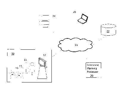
[0024] FIG. 1 is a diagram illustrating an environment at which embodiments
of the present
inventive concepts may be practiced.
[0025] FIG. 2 is a block diagram of a kiosk, in accordance with some
embodiments.
[0026] FIG. 3 is a block diagram of a landscape planning processor, in
accordance with some
embodiments.
[0027] FIG. 4 is an illustration of flow paths between elements of the
environment of FIG. 1,
in accordance with some embodiment.
[0028] FIG. 5 is a flow diagram illustrating a landscape design process, in
accordance with
some embodiments.
[0029] FIG. 6A is a screenshot of a 2 dimensional satellite image.
[0030] FIG. 6B is a 3 dimensional representation of the 2-D satellite image
of FIG. 6A, in
accordance with some embodiments.
[0031] FIG. 6C is a 3 dimensional representation of the 2-D satellite image
of FIG. 6A
overlaid with a simulation produced according to a recommendation generated by
a landscape
planning processor, in accordance with some embodiments.
DETAILED DESCRIPTION
[0032] In the following description, specific details are set forth
although it should be
appreciated by one of ordinary skill in the art that the systems and methods
can be practiced
4
CA 2974314 2017-07-21
without at least some of the details. In some instances, known features or
processes are not
described in detail so as to not obscure the present invention.
[0033] FIG. 1 is a diagram illustrating an environment at which embodiments
of the present
inventive concepts may be practiced.
[0034] A store customer 11 may be present in a garden center or other
landscape-related
store 10, where garden-related items 13 are offered. At the store 10, a kiosk
12 may be available
for use by the customer 11, or other user of the kiosk 12. In some
embodiments, the kiosk 12 is
located at another public location such as a mall, airport, and so on.
[0035] A landscape design system may include other electronic components
that
communicate with the kiosk 12 and a user computer 14 such as a smartphone,
notebook
computer, and so on in possession by the customer 11. As shown in FIG. 1,
other electronic
components may include but not be limited to a landscape planning processor
20, data repository
22, and 3-D printer 24, which may communicate with each other and/or other
electronic devices
via network 16. The network 16 may be a public switched telephone network
(PSTN), a mobile
communications network, a data network, such as a local area network (LAN) or
wide area
network (WAN), or a combination thereof, or other communication network known
to those of
ordinary skill in the art.
[0036] The landscape planning processor 20 processes inputs for generating
landscape or
garden design recommendation. For example, the landscape planning processor 20
may process
a 2-dimensional (2-D) satellite image of a customer's property, which may
include relevant
details such as the customer's home, property fence, existing garden,
shrubbery, walkways, and
so on, and convert relevant portions of the satellite image into a 3-
dimensional (3-D)
representation, or model, of the property, or at least a portion identified as
being of interest by
the user 11. In particular, 2-D data gathered from a satellite may be
converted using a special-
purpose processor into a 3-D image. The landscape planning processor 20 may
generate
recommended improvements to the selected region of the property based on user
inputs, such as
flower preferences, garden tools of interest, projects, and so on.
[0037] The data repository 22 may be a database or the like located
remotely from the store
and accessible by the kiosk 12, landscape planning processor 20, and/or other
electronic
device used by the user 11. The data repository 22 may store information
regarding real
5
CA 2974314 2017-07-21
properties, such as maps, deeds, satellite images, and/or other information
regarding a property
of interest, which may be a candidate for landscape modifications. This
information may be
used by the landscape planning processor 20 to generate a 3-D representation
of a user's
property.
[0038] A remote computer 26 may be used to view or otherwise access
simulation results, 3-
D models, and so on produced by the landscape planning processor 20.
Therefore, some or all
features provided by the kiosk 12 may likewise be performed at the remote
computer 26.
[0039] FIG. 2 is a block diagram of a kiosk 12, in accordance with some
embodiments. The
kiosk 12 may be part of the environment illustrated in FIG. 1.
[0040] The kiosk 12 includes a first input device 32, a second input device
34, a display 36, a
user interface 38, a modification processor 40, and a processor interface 42.
Some or all of these
elements are stored in an electronic memory device and executed by a hardware
processor of the
kiosk 12. Some or all of these elements include hardware processors for
performing functions of
the elements. In some embodiments, at least some of these elements are
performed on other
electronic devices instead of the kiosk 12, which are in communication with
the kiosk 12, for
example, via the network 16.
[0041] The first input device 32 and the second input device 34 may include
the same inputs
or different inputs. For example, the first input device 32 and the second
input device 34 may
include a common physical connector to a network device for communicating with
the network
16.
[0042] The first input device 32 is constructed and arranged to receive 2
dimensional data
from the landscape planning processor 20, or directly from a data repository
22 or other
information source, for example, which stores a satellite image of real
property, also referred to
as a land property, real estate, and so on.
[0043] The second input device 34 may include a touchscreen, mouse,
keyboard, and so on
for providing user input such as address information, specific requests,
information in response
to a displayed inquiry displayed by the user interface 38, and so on.
[0044] The display 36, e.g., a liquid crystal display or the like, is
constructed and arranged
for displaying a 2-D satellite image so that a user 11 can identify regions of
the image for
6
CA 2974314 2017-07-21
converting into a 3-D representation of a region of interest of the property
displayed in the
satellite image. FIGs. 6A and 6B illustrate a 2-D satellite image 601 and 3-D
representation 602
of the satellite image, respectively, each of which may be displayed at the
display 36. The
display 36 can also display information regarding suggested item purchases,
recommended
landscape-regarding designs, simulations of a recommended landscape design
(for example,
shown in FIG. 6C), and so on. The user interface 38 may generate for display a
time-of-day bar
or the like, which identifies a location of the sun and an amount of shade at
the selected region of
the land property at a time of day. Data regarding the location or the sun,
amount of shade, etc.
may be processed by the landscape planning processor 20, which in turn can be
used to establish
the time-of-day bar, and wherein the recommended improvements take into
account the location
of the sun and an amount of shade at the selected region of the land property
at the selected time
of day.
[0045] The modification processor 40 receives from the second user device
34 data input by
the customer 11 and/or the display 36 regarding customer-proposed
modifications to the
identified regions of the 2-D satellite image. For example, the customer 11
may select a region
of interest from the displayed 2-D satellite image. The modification processor
40 can present
options for the customer 11 to modify the selected open region of interest,
for example, build a
garden, fire pit, stone wall, and so on at the selected region of the
displayed property. The
presented options may be generated by the landscape planning processor 20, by
analyzing the
selected open region of interest and producing recommendations which are
output as options to
the modification processor 40.
[0046] The modification processor 40 can present a recommended option as a
3-D
representation produced by and received from the landscape planning processor
20. For example,
a 3-D representation may include a view of the property as provided in the 2-D
satellite image,
and overlaid with a realistic-looking replication of, shrubs, mulch, stones,
patios, walls, fire pits,
or the like identified in the user's desired or recommended property
improvements by the
landscape planning processor 20, for example, shown in the image 603 of FIG.
6C. The overlaid
features may include dimensions, materials, shapes, and so on according to
user input submitted
via the second input device 34. The modification processor 40 may generate a
recommended
property improvement based on the user input and/or external data provided by
the landscape
planning processor 20. For example, a user may select a region of the property
for adding a fire
7
CA 2974314 2017-07-21
pit, along with dimensions of the fire pit. The modification processor 40 may
produce a different
simulation, for example, display the fire pit at a different location than the
user's choice due to
information received from an external source by the landscape planning
processor 20 that there is
a swamp, and therefore, mosquito beds, near the user's selected region of the
property. .
[0047] The processor interface 42 exchanges data with the landscape
planning processor 20
and receives data such as recommendations, modifications, simulation data, or
the like from the
landscape planning processor 20, for example, illustrated in the previous
example.
[0048] FIG. 3 is a block diagram of a landscape planning processor 20, in
accordance with
some embodiments. The landscape planning processor 20 may be part of the
environment
illustrated in FIG. 1.
[0049] The landscape processor 20 comprises a first processor 52, a second
processor 54, a
converter 56, a simulator 58, a notification generator 60, a third processor
62, and a
recommendation engine 64. Although these components of the landscape processor
20 are
shown as being part of a common hardware platform, some or all of first
processor 52, second
processor 54, converter 56, simulator 58, notification generator 60, third
processor 62, and
recommendation engine 64 can be at other hardware platforms, for example, at
the kiosk 12.
[0050] The first processor 52 retrieves a two-dimensional image of a real
property in
response to a query by a user 11. The user 11 may submit a query to the kiosk
12 or mobile
computing device 15 at the store 10 for a particular property, such as the
user's home or other
real property. Alternatively, the user 11 may submit a query at a remote
location from the store
10, for example, at a user computer 14, or for a particular property, such as
the user's home or
other real property. A map, diagram, satellite image, and/or other 2-
dimensional image of the
requested real property may be electronically stored at the data repository
22.
[0051] The second processor 54 generates for display a two-dimensional view
of a region of
a real property of interest for simulation. For example, the user 11 may view
at a kiosk or
personal computer display screen a retrieved satellite image of a property of
interest, and select a
region of the satellite image for possible landscape improvements such as the
addition of
shrubbery, gardens, walkways, and so on, which is processed by the second
processor 54 for
display, for example, as an enlarged view relative to the original satellite
image. The system
may recognize certain features from the satellite image by image or object
recognition
8
CA 2974314 2017-07-21
techniques known to those of ordinary skill in the art. The viewer 11 may
validate such
identified features such as trees, ponds, driveways, and so on, for example,
by providing input
regarding improvements of interest to the landscape shown in the image.
[0052] The converter 56 converts the selected region of the displayed two-
dimensional view
into a three-dimensional image, which may replace or coexist with the two-
dimensional view
displayed on the display screen. The three-dimensional image generated may be
based on depth
assumptions provided by the customer 11 such as depth of a ditch, the slope of
a hillside, the
height of a tree, and so on. The converter 56 distinguishes from the
modification processor 40
of the kiosk 12 in that the converter 56 performs a conversion function, while
the modification
processor 40 processes a converted file and overlays it with simulation
details, as described
above.
[0053] The simulator 58 updates the three-dimensional image of the real
property according
to recommended improvements to the real property, and outputs the result to
the modification
processor 40 of the kiosk 12. In particular, the simulator 58 places virtual
plants, objects, and so
on into a generated 3-D model. Here, the user 11 may view on a display screen
what the user's
selected property would look like if updated, for example, during various
stages of a growing
season based on predictive assumptions over time under specified conditions.
Predictive
assumptions may be received from external data sources, such as the Farmer's
Almanac or other
predictive sources. Specified conditions may likewise be received from
external sources such as
a data repository that stores historical weather data.
[0054] The notification generator 60 may output alerts to the user 11
regarding landscape-
related actions the user 11 should take regarding an identified region of the
property of interest,
such as a garden that needs water based on predetermined rainfall. This data
may be retrieved by
the third processor 62 from an external data source, such as a weather-centric
website, which
includes data on type of soil, sunshine, humidity, and so on. Other alerts may
pertain to when to
fertilize, type of fertilizer, time of day to fertilize, etc. Other alerts may
be on what insecticides
to use, how to control insects, grubs based on time of year, how to keep
animals from destroying
plants, etc. Other alerts may be to alert the customer when to cover the
plans, i.e., due to frost,
hail, etc. Other alerts may be when to plant seeds, bulbs, digging
up/transplants, etc. Other alerts
may be when to trim hedges, mow law, etc. ¨ weekly, etc. Here, the
recommendation engine 64
9
CA 2974314 2017-07-21
can recommend tools for performing this function. Another notification may be
remind the user
11 when they need certain products to keep garden healthy, or other care. The
user 11 via a
personal computing device can receive alerts to assist the user 11 with future
gardening
suggestions, inputs, and so on.
[0055] The third processor 62 retrieves data from a remote database that is
used for
generating simulation images and/or options for improving a selected region of
property shown I
in the images that are part of a simulation of the three-dimensional image of
the user's property.
[0056] The recommendation engine 64 generates recommendations on selected
regions of a
2-D image of a real property. The recommendation engine 64 may receive a
combination of user
inputs via the kiosk 12, such as types of plants, flowers, shrubs, selected by
the user 11, and
inputs received from external sources via the third processor 62, such as
fertilization options,
rainfall estimates at the address of the selected property, and so on. Also,
the recommendation
engine 64 may recognize and analyze certain items on the displayed 2-D image,
such as trees or
plants currently at the property that produce shade, type and/or acidity of
soil, and so on. For
example, the system 20 may determine a type of tree without recognizing the
leaves on the tree
by determining a height of the tree from shadows over time of day based on sun
location which
is captured by the images. The color of leaves may be determined in the fall,
the time at which
blooms are seen, a comparison of other known species, and so on.
[0057] A generated recommendation may include information regarding
purchases made
regarding the recommended improvements to the user's property. For example,
the customer
may have purchased a tree at the store. This information may be used to
generate a
recommendation to plant the tree at a particular region of the user's property
based on soil
conditions. Other recommendations may include suggested locations for placing
stepping
stones, gazebos, lawn furniture, and so on. Other recommendations may include
specific product
recommendations based on collected data, for example, particular weed killer
products to use
based on soil content, plant types, and so on.
[0058] FIG. 4 is an illustration of flow paths between elements of the
environment of FIG. 1,
in accordance with some embodiment.
CA 2974314 2017-07-21
[0059] At step 202, a kiosk 12 receives a user input, namely, an address or
other identifier of
a real property of interest to a user 11 of the kiosk 12. The user 11 may be a
store customer
interested in improving a home or business by purchasing items and/or services
used for
gardening, landscaping, and so on.
[0060] At step 204, the kiosk 12 generates and outputs a request to the
landscape planning
processor 20 for an electronic image of the real property corresponding to the
address or other
identifier entered in step 202. Other data related to the address or other
identifier may be
included with or instead of the image data. The requested image data may
include a satellite
image, map, or other visual representation of the real property of interest.
[0061] At step 206, the landscape planning processor 20 provides a result,
namely, a 2-D
map or satellite image, of the real property identified in step 202. The
landscape planning
processor 20 may send a query to the data repository 22 and/or other remote
repository where
this data is known to be available.
[0062] At step 208, a user 11 may view on the kiosk display 36 the 2-D
image and identify
via the second input device 34, e.g., a touchscreen, mouse, keyboard, and so
on a region of the
2-D image where the user 11 desires to perform a landscape-related function,
such as gardening,
building a stone wall, and so on. The user 11 may also input other information
such as desired
landscape projects, types of plants to grow, and so on.
[0063] At step 210, the kiosk 12 outputs the user input data provided in
step 208 to the
landscape planning processor 20, which at step 212 generates a 3-D image from
the received user
input data and 2-D image.
[0064] At step 214, the 3-D image if output from the landscape planning
processor 20 to the
kiosk 12 for display. This permits a gardener can walk through and see what
the garden look
like during various stages of the growing season based on predictive
assumptions over time
under specified conditions. In some embodiments, this may be achieved by the
landscape
planning processor 20 applying imaging time-lapse animation techniques or the
like to a
produced three-dimensional (3-D) video image.
11
CA 2974314 2017-07-21
[0065] At step 216, the 3-D image of the user's property picture overlaid
with realistic-
looking shrubs, mulch, stones, patios, walls, or the like identified in the
user's desired or
computer-recommended property improvements design is optionally generated by a
3-D printer
24 or the like, and/or displayed at the kiosk display 36.
[0066] FIG. 5 is a flow diagram illustrating a landscape design process, in
accordance with
some embodiments. In describing the method, reference may be made of elements
of FIGs. 1-4.
[0067] At block 402, a kiosk 12 is accessed by a user interested in
landscape design,
modification, and/or other related information.
[0068] At block 404, a satellite image is retrieved by the kiosk 12, for
example, by the first
processor 32 of the kiosk 12. A plurality of satellite images of the same
property taken at
different times may be stored. Thus, a most recent satellite may be retrieved.
[0069] At block 406 the user 11 may review the two-dimensional image
displayed at the
kiosk 12 or remote computer 26. The user 11 may determine whether the
retrieved satellite
image is a recent display, i.e., that it correctly captures the property of
interest. For example, an
older satellite image may not display recent property changes, such as an
addition to the home, a
new swimming pool, and so on.
[0070] At decision diamond 408, the kiosk 12 via the user interface 38 may
present a request
for the user to select whether the retrieved and displayed satellite image is
a correct, i.e., most
recent, version. If no, then the method proceed to block 410, where a store
associate 17 or other
authorized representative may direct a satellite to generate at least one new
image of the property
of interest. In other embodiments, the satellite images are retrieved from a
third party database.
The system may determine if the image of interest can be digitally aged,
locate a later image than
an image at hand, or request an updated image.
[0071] At block 412, the satellite generates the new images as directed.
The new images
may be stored at a data repository 22 or other remote data storage device. At
block 416, options
are presented at the kiosk 12 for possible improvements to the property
identified in the image.
The system may identify open or available regions of the property from the
image that are
candidates for improvement, and generate options for improving these areas.
12
CA 2974314 2017-07-21
[0072] Returning to decision diamond 408, if the kiosk 12 establishes that
the images are
recent images and acceptable for subsequent processing, then the method may
proceed directly to
block 416.
[0073] At block 418, the customer 11 may select options of the presented
options at block
416 for open spaces of interest, where possible landscape modifications may be
made. For
example, a displayed 2-D image may illustrate an open space in a front lawn
between the front
door of the home shown on the property and the street. The open space may be
surrounded by
pine trees on the front lawn. The customer 11 may select from the kiosk 12
this displayed open
space.
[0074] At block 420, the landscape planning processor 420 can analyze
selected options and
generate recommended items or services for performing the selected options.
For example, the
third processor 62 may retrieve information from a website regarding seasonal
growing
preferences at the location of the selected property. This data can be used to
establish that
orange trees are not appropriate for adding to the property, but apple trees
are appropriate. In
another example, the landscape planning processor 420 may establish from an
image that the
property includes pine trees, and establish from a remote source that the lawn
is highly acidic
due to the presence of pine trees, then recommend a particular type of grass
conducive to an
acidic soil.
[0075] At block 422, recommendations may be displayed at the kiosk 12 or
remote computer
display 26 for consideration by the shopper 12.
[0076] At block 424, a selected recommendation option may be output, for
example, formed
on a 3-D printer, and/or displayed at the kiosk 12 or remote computer display
26. A simulation
result, for example, a simulation shown at FIG. 6C, may be provided to a
remote computing
device, such as a user's smartphone, which may permit the user to perform an
augmented
walkthrough of the property using the smartphone. A smartphone or other
electronic device may
also be used to communicate with the kiosk 12, for example, to retrieve and
process relevant
results produced at the kiosk 12.
13
CA 2974314 2017-07-21
[0077] In some embodiments, the system may be integrated with an online
shopping site or
the like, which provides an approach for ordering products, shipping, and
payment methods.
[0078] As will be appreciated by one skilled in the art, concepts may be
embodied as a
device, system, method, or computer program product. Accordingly, aspects may
take the form
of an entirely hardware embodiment, an entirely software embodiment (including
firmware,
resident software, micro-code, etc.) or an embodiment combining software and
hardware aspects
that may all generally be referred to herein as a "circuit," "module" or
"system." Furthermore,
aspects may take the form of a computer program product embodied in one or
more computer
readable medium(s) having computer readable program code embodied thereon.
[0079] Computer program code for carrying out operations for the concepts
may be written
in any combination of one or more programming languages, including an object
oriented
programming language such as Java, Smalltalk, C++ or the like and conventional
procedural
programming languages, such as the "C" programming language or similar
programming
languages. The program code may execute entirely on the user's computer,
partly on the user's
computer, as a stand-alone software package, partly on the user's computer and
partly on a
remote computer or entirely on the remote computer or server. In the latter
scenario, the remote
computer may be connected to the user's computer through any type of network,
including a
local area network (LAN) or a wide area network (WAN), or the connection may
be made to an
external computer (for example, through the Internet using an Internet Service
Provider).
[0080] Concepts are described herein with reference to flowchart
illustrations and/or block
diagrams of methods, apparatus (systems) and computer program products
according to
embodiments. It will be understood that each block of the flowchart
illustrations and/or block
diagrams, and combinations of blocks in the flowchart illustrations and/or
block diagrams, can
be implemented by computer program instructions. These computer program
instructions may
be provided to a processor of a general purpose computer, special purpose
computer, or other
programmable data processing apparatus to produce a machine, such that the
instructions, which
execute via the processor of the computer or other programmable data
processing apparatus,
create means for implementing the functions/acts specified in the flowchart
and/or block diagram
block or blocks.
14
CA 2974314 2017-07-21
[0081] These computer program instructions may also be stored in a computer
readable
medium that can direct a computer, other programmable data processing
apparatus, or other
devices to function in a particular manner, such that the instructions stored
in the computer
readable medium produce an article of manufacture including instructions which
implement the
function/act specified in the flowchart and/or block diagram block or blocks.
[0082] The computer program instructions may also be loaded onto a
computer, other
programmable data processing apparatus, cloud-based infrastructure
architecture, or other
devices to cause a series of operational steps to be performed on the
computer, other
programmable apparatus or other devices to produce a computer implemented
process such that
the instructions which execute on the computer or other programmable apparatus
provide
processes for implementing the functions/acts specified in the flowchart
and/or block diagram
block or blocks.
[0083] The flowchart and block diagrams in the Figures illustrate the
architecture,
functionality, and operation of possible implementations of systems, methods
and computer
program products according to various embodiments. In this regard, each block
in the flowchart
or block diagrams may represent a module, segment, or portion of code, which
comprises one or
more executable instructions for implementing the specified logical
function(s). It should also be
noted that, in some alternative implementations, the functions noted in the
block may occur out
of the order noted in the figures. For example, two blocks shown in succession
may, in fact, be
executed substantially concurrently, or the blocks may sometimes be executed
in the reverse
order, depending upon the functionality involved. It will also be noted that
each block of the
block diagrams and/or flowchart illustration, and combinations of blocks in
the block diagrams
and/or flowchart illustration, can be implemented by special purpose hardware-
based systems
that perform the specified functions or acts, or combinations of special
purpose hardware and
computer instructions.
[0084] While concepts have been shown and described with reference to
specific preferred
embodiments, it should be understood by those skilled in the art that various
changes in form and
detail may be made therein without departing from the spirit and scope as
defined by the
following claims.
CA 2974314 2017-07-21