Note: Descriptions are shown in the official language in which they were submitted.
SUBSURFACE ROBOTIC MAPPING SYSTEM AND METHOD
Field of the Invention
This invention relates to subsurface mapping systems. In particular, this
invention relates to a mapping system for real-time mapping of a path and/or
surface
in a subsurface cavity, such as a tunnel, and employing subsurface avionics
for
navigation purposes.
Background of the Invention
In environments that are unsuitable or hostile for humans, robots are
particularly suited to perform tasks that would otherwise be performed by
humans. An
example of such an inhospitable environment that would benefit from robotics
is
subsurface mapping, such as the mapping of a tunnel or cavity underground.
A specific application of subsurface mapping is the charting and mapping
of tunnels such as sewer tunnels. In such subsurface environments, ventilation
is poor
and the environment may be partially or fully flooded with water and/or liquid
waste.
As a result, personnel entry is either forbidden, or requires the use of
specialized
ventilators.
Many regions are faced with trying to accommodate current, as well as old
and dis-used, tunnel systems. It would be advantageous to use a robotic system
for
charting and/or mapping a subsurface cavity. It would also be advantageous to
control
subsurface robots in the system with a navigation system that employs
avionics.
Navigation systems for the operation and geo-positioning of aircraft,
watercraft and land-based vehicles are well known in the art. In general, many
navigation systems include one or more subsystems that are integrated to
provide the
most accurate positioning possible. Often, inertial navigation systems are
used with
one or more sensors to calculate the position, orientation and velocity as a
moving
object as it travels. However, subsurface navigation presents challenges that
are not
encountered with traditional surface (land or water) or aerial navigation
systems due
to the inherent restrictions on line-of-sight communication in the subsurface
and the
limitations on data transmission through the subsurface environment.
- 1 -
CA 2975094 2017-08-02
Inertial navigation systems use local measurements from on-board sensors
over time and certain algorithms to produce a best estimate of position as an
object
moves from an initial position. Sensors known in the art as "dead-reckoning"
sensors
measure acceleration and angular velocity from which integrative functions
produce a
distance and vector relative to an initial reference coordinate position. A
known
problem with inertial navigation systems is the deterioration of accuracy over
time due
to the accumulation of unbounded errors with each measurement.
To compensate for these unbounded errors, many navigation systems for
surface or aerial applications augment the inertial system with a
complementary
system, such as a positioning system, that aids in reducing the effect of
accumulating
measurement errors. For example, Global Positioning Systems (GPS) are often
used in
commercial airplane avionics to periodically update and correct the inertial
system
with external position measurements.
While inertial navigation systems have been used for subsurface
applications, traditional GPS has not been used to compensate for the problems
associated with unbounded errors in the subsurface data transmissions given
that the
ability to obtain an accurate geographical position using GPS requires
triangulation of
signals from at least three satellites by line-of-sight transmission from each
satellite to
the GPS receiver. As a result, inertial systems have found limited application
in the
subsurface and are known to have limited accuracy that degrades as the
distance from
the initial reference point increases spatially and temporally.
It would be advantageous to provide a subsurface avionics system that
includes an inertial navigation system or some other means of navigation that
can be
supplemented with a means of external reference for accurate real-time
positional re-
calibration of the inertial navigation system.
Brief Description of the Drawings
In drawings which illustrate by way of example only a preferred
embodiment of the invention,
Figure 1 is an isometric cutaway view of a robotic mapping system;
- 2 -
CA 2975094 2017-08-02
Figure 2 shows perspective views of an embodiment of a mapping
telerobot;
Figure 3 provides exemplary still images of underground sewer conditions;
Figure 4 provides exemplary thermal images of a sewer;
Figure 5 provides exemplary geospatially positioned laser scans;
Figure 6 is a perspective view of an embodiment of a subsurface mapping
generated from a fusion of a plurality of sensor readings from outside the
cavity;
Figure 7 is a view of the subsurface mapping from within the cavity;
Figure 8 illustrates a further embodiment of a robotic mapping system;
Figure 9 is a schematic diagram of an avionics navigation system;
Figure 10 is a diagram of a typical XYZ reference frame;
Figure llis a diagram showing typical yaw, roll and pitch;
Figure 12 is a schematic diagram of an avionics navigation system at
reference time T1;
Figure 13 is a schematic diagram of an avionics navigation system at
reference time T2;
Figure 14 is a schematic diagram of an avionics navigation system at
reference time T3.
Detailed Description of the Invention
In an embodiment, a robotic subsurface mapping system is provided that
may comprise a mobile control centre for location on the surface near an
access shaft
to the subsurface to be mapped; a support located proximate to the access
shaft, for
supporting a tether; the tether affixed to the support and affixed to at least
one robot,
the tether selected to provide physical restraint of the at least one robot;
the at least
- 3 -
CA 2975094 2017-08-02
one robot comprising: at least sensor for generating scanning data for
detecting the
subsurface in relation to the at least one robot; a geospatial positioning
system for
continuously generating geospatial data for determining the geospatial
position of the
at least one robot; a controller for collecting and storing the geospatial
data and the
scanning data associated with timing data; a wireless communications device
for
transmitting the collected geospatial data, the scanning data and the
associated timing
data to communicate the geospatial data, the scanning data and the associated
timing
data to the mobile control centre.
The robotic mapping system is capable of charting or mapping a path
through an underground cavity, and/or mapping a surface of the underground
cavity.
The application is described in relation to sewer tunnels, though the surfaces
of other
subsurface cavities may similarly be mapped. The condition of the subsurface
cavity is
often unknown from the surface, and can change, with the robots potentially
operating
in a dry, partially submerged, and fully submerged environment.
The mapping robots may also be teleoperated. The present application also
provides a subsurface avionics system (SAS), preferred embodiment of which is
illustrated in Figure 10, and a subsurface avionics method, which is adaptable
to
virtually any subsurface environment or any fluid mass and is particularly
suitable for
use in subsurface engineering, subsurface mining and underwater mining
environments. The system and method of the invention will be described in the
context of subsurface engineering, but it has applications in other
environments and
the description is not intended to be limiting in this regard. For instance,
without
limitation, the system and method of the invention also has application as a
positioning system for humans (which can also be 'vehicles' for transporting
the
system) and assets in subsurface environments, which may include subterranean,
submarine, or subglacial environments (both terrestrial and extra-
terrestrial), such as,
without limitation, within lakes, ponds, oceans, seas, ice bodies, pipes,
sewers,
tunnels, mine shafts, cavities, and below surface of the moon or other non-
earth
bodies.
- 4 -
CA 2975094 2017-08-02
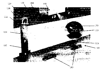
Referring to Figure 1, one embodiment of a telerobotic mapping system
100 is illustrated. In the illustration a surface 105 of a subsurface cavity
102, such as a
sewer tunnel, is being mapped by the robotic mapping system 100. A mobile
control
centre 110 is located proximate to an access shaft 103. The mobile control
centre may
comprise a teleoperation console 115 that provides information to an operator
on one
or more view screens 120.
The mobile control centre 110 is in communication via communication
link 112 with a wireless relay 107 situated to communicate wirelessly to a
teleoperated mapping telerobot 160 located in the access shaft 103. In an
embodiment,
the wireless relay 107 may either be located at a base of the access shaft 103
in the
subsurface cavity 102, or situated to communicate with a secondary relay
located in
the subsurface cavity 102, to communicate directly with the mapping
telerobot(s) 160
in the subsurface cavity 102.
The telerobots 160 may each be connected to one another, and to a support
108 by a physical tether 150, such as an aircraft cable. In an aspect, each
robot 160
may be connected to an end of a separate tether 160 in daisy chain fashion. In
an
alternate embodiment, a single continuous tether 150 may be used, and the
robots 160
attached at locations along the tether 150.
In an embodiment of the robotic mapping system 100, the tether 150 is
neither a communications nor a power cable, but only a physical tether. The
purpose
of the tether 150 being to provide a means to withdraw the telerobots 160 from
the
subsurface cavity 160, and to restrain them within the subsurface cavity 102
in case of
flood or drop off. The use of tether 150 that is only a physical tether allows
for
flexible, relatively lightweight tether that may be fed deep into a subsurface
cavity
102, and may be conveyed by the telerobots 160 if necessary along the ground
of the
cavity 102. The telerobots 160 communicate through the subsurface cavity 102
by
wireless communication between robots 160. Accordingly, the series of
telerobots 160
act as a relay to convey communication between the lead robot 160 and the
mobile
control centre 110.
- 5 -
CA 2975094 2017-08-02
One embodiment of a telerobot 160 is illustrated in Figure 2. The telerobot
160 shown in Figure 2, which may be the lead telerobot 160 in a daisy chain of
such
robots, comprises a sensor package for mapping at least one surface 105 of the
subsurface cavity 102.
Referring to Figure 2, the telerobot 200 may comprise a chassis 205
supporting opposed drive units 210 separated by a payload. The payload may be,
for
example, a sensor package 220 (as illustrated in the figure) or it may be a
communications module that allows for data processing and communications
relay, or
it may be any combination thereof. The drive units 210 are operative to propel
the
lo robot 160 when in a dry or partially submerged environment. The payload
may further
contain a battery to power the telerbobot 160.
The drive units may further contain an ethernet switch, radio and antenna,
a light, a video encoder, a gas nipple, fuse, charging plug and on/off switch,
all of
which are components known to the skilled person.
A processor may be mounted in the payload in a shock and impact resistant
casing that allows for thermal dissipation of heat from the processor.
Further, as
subsurface environments may be hazardous, the telerobot 160 itself is built to
be
resistant to the shock of explosions, and provides no ignition source to cause
explosions in the presence of explosive gases in mine shafts or any flammable
liquids.
In one embodiment, the sensor package 220 may comprise a plurality of
sensors. In the embodiment of Figure 2, the sensor package 220 comprises a
plurality
of Infrared cameras 225, a laser scanner 230. In one embodiment, the telerobot
160
may further comprise a thermal imaging camera, and/or sonar or radar sensors
(not
shown).
The telerobot 160 further includes a geospatial positioning system, such as
by using sensitive gyroscopes and/or accelerometers, and a controller and
memory for
collecting and storing the geospatial positioning data, along with the imaging
and
scanning data. In an aspect, the controller may further comprise a clock for
generating
- 6 -
CA 2975094 2017-08-02
timing data that may be used to associate the geospatial data with the imaging
and
scanning data.
While it may be preferred to communicate the data wirelessly to the mobile
control centre 110 to ensure capture of the data, it is also preferred to
maintain a local
copy of the data on the telerobot 160 in case wireless communications are not
possible, to buffer in case of slow communication rates, and to provide a back-
up
copy in case the wireless communication is otherwise lost. Wireless
communication
of the data is preferred as the subsurface environment is dangerous, and it is
generally
advantageous to relay the captured information to the surface as soon as
practically
possible in case of loss of equipment in the subsurface cavity 102.
In operation, the telerobot 160 continuously captures geospatial data,
imaging, and scanning data, and stores it in association with corresponding
timing
data. In an aspect the stored data may further be transmitted by wireless
communication through the subsurface cavity 102 via a series of telcrobots 160
to
reach the relay 107 at the surface, and be conveyed to the mobile control
centre 110.
Testing of the telerobotic mapping system 100 was completed in mine and
a mine map data set was compiled. The data set could be accurately measured
and
used for several mine applications such as equipment fit, ventilation surface
roughness
determination, mine road quality and tunnel construction quality.
Figure 3 provides exemplary photos of underground sewer conditions
taken by a telerobot 160 of the present invention during testing.
Figure 4 provides exemplary thermal images of a sewer. Thermal imaging
may be used to assist in assessing tunnel conditions, as well as structural
issues that
may be present, such as identifying leaks in the tunnel wall. In the thermal
images in
Figure 4, the water level of the tunnel can be seen, as well as objects in the
path of the
sensor. Leaks are identifiable in the lower left hand side image, though
difficult to see
without image processing to enhance the features. The right hand image in
Figure 4
shows a hot water pipe and a cold water pipe. In one embodiment, thermal
imaging
may be used to assist in leak detection within tunnels. The leak can be
identified as a
- 7 -
CA 2975094 2017-08-02
hot spot (e.g. hot water) or a cold spot (e.g. cold supply water, ground
water, etc.) on
the thermal image. A thermal image of a hot and cold water pipe is simpler to
distinguish with the naked eye from a non-processed thermal image, than an
actual
tunnel wall leak. An identified leak may be tagged with the geospatial
position of the
telcrobot 160 at the time of image capture. This information may be
subsequently used
to affect a repair of the leak.
Figure 5 provides exemplary geospatially positioned laser scans and
renderings taken by the laser scanner of a telerobot 160.
Figure 6 is an exemplar mapping of a surface of a subsurface cavity
constructed by combining the imaging and scanning data collected for each
geospatial
location. In an aspect, the mobile control centre 110 may be operative to
generate the
mapping from data transmitted wirelessly from the telerobots 160 in the
subsurface
cavity 102.
Figure 7 is a further view of the exemplar mapping of Figure 6 from within
the subsurface cavity. The mapping is generated by combining the laser scan
data, the
infrared data, the thermal imaging, sonar, radar, or other scanning and
imaging data
taken at each geospatial location within the subsurface cavity 102.
In an alternative embodiment, communications from the mobile control
centre 110 may be facilitated not by a daisy chain of telerobots 160 but by
the
inclusion of a plurality of relays 705 located within the subsurface cavity
102. Figure
8 is a schematic diagram showing an installation whereby an additional access
tunnel
720 to the subsurface cavity 102 has been used to provide for a remote relay
707
separate from the mobile control centre 110. The plurality of relays 705
within the
subsurface cavity 102 to provide communications to the telerobot(s) 160. The
additional access tunnel 720 provides for a direct wired connection 722 to the
remote
relay 707. A mobile wireless relay 710 is provided above ground to provide a
communications link between the mobile control centre 110 and the remote relay
707.
In this fashion for extended underground networks, such as sewer systems, the
mobile
control centre 110 can maintain a plurality of communications paths to the
robot 760,
- 8 -
CA 2975094 2017-08-02
and even switch communication paths as the distance traversed makes the
tethered
relay system impractical.
In a further embodiment, to provide data regarding an underground area
that is correctly geospatially situated, and therefore measurable with
reference to
locations in the real world, the telerobot 160 is equipped with an inertial
navigation
system to locate the telerobot 160 in space. This allows data captured by the
telerobot
160 to be associated with a geospatial location. The inertial navigation
system is able
to provide the mobile control centre 110 with real time data regarding the
position of
the telerobot 160 within the mine cavity, or otherwise within the area for
which data is
being collected.
Referring now to Figure 9, the telerobot 160 is equipped with a subsurface
avionics navigation system comprising a multisensor navigation subsystem and a
communications subsystem. It will be appreciated by those skilled in the art
that the
system of this embodiment could also be used with a different vehicle, such as
affixed
to or carried by or on humans (for example, miners) or affixed to, carried by,
or
integrated with assets¨such as machinery, vehicles, submersible crafts, or
automated
devices¨within a subsurface environment (including an underwater environment),
and perform the same or similar function. Typical subsurface environments for
the
subsurface avionics system of the present invention include, without
limitation, pipes,
sewers, tunnels, underwater environments (including open water or underwater
caves/tunnels), and below the surface of the moon or other extraterrestrial
body.
The multisensor navigation subsystem of the subsurface avionics system
shown in Figure 9 combines an inertial navigation system with a subsurface
positioning navigation system. The inertial navigation system is used to track
movement in the subsurface relative to the initial position of the telerobot
160 and the
subsurface positioning navigation system is used as an intermittent
recalibration or
verification of the inertial system by triangulation using signals generated
by localized
antennae. The subsurface positioning navigation system acts to verify or re-
calibrate
positioning to reduce or compensate for unbounded errors generated by the
inertial
navigation system as the telerobot travels through the subsurface.
- 9 -
CA 2975094 2017-08-02
In the embodiment of Figure 9, the primary means of navigation employed
by the subsurface telerobot is through the use of the on-board inertial
navigation
system, which may be a Subsurface Avionics System (SAS) element. The inertial
navigation system of this embodiment is calibrated to start from a known
geospatial
position as an initial reference point. For example, the initial geospatially
known
reference point may be the tunnel entrance or access shaft 103 entrance (see
Figure 1).
As the telerobot 160 moves down the tunnel from the initial position, on-board
instrumentation generates data related to the vertical, horizontal and
rotational
movement of the telerobot 160 from the initial reference point. As the
telerobot 160
moves through the subsurface, the data generated from the instrumentation may
be
used by the inertial navigation system to derive the three-dimensional
movement of
the telerobot 160 within the subsurface and to provide an estimate of the
three-
dimensional position of the telerobot 160 in the subsurface relative to the
initial
reference point.
The inertial navigation system of the telerobot 160 of this embodiment
may be a conventional inertial navigation system known in the art. The system
uses
the principles of dead reckoning that uses known location, velocity and time
to give
displacement, therefore new location. In general, sensitive accelerometers and
gyroscopes on the stable telerobot 160 platform are used to sense the change
in
acceleration as the telerobot 160 as it moves through the subsurface, which
are then
used to determine the velocity of the telerobot 160 and the displacement from
its
initial position.
As the telerobot 160 begins to move, the accelerometers sense the change
in movement and produce an output signal used with algorithms to calculate
velocity.
In general, three accelerometers may be used to sense the (a) horizontal
component of
movement in one plane (the X axis), (b) horizontal component of movement in a
second plane perpendicular to the first plane (the Y axis), and (c) the
vertical
component of movement (the Z axis) perpendicular to both planes. The
accelerometers are affected by gravity that will constantly hold the
accelerometers in
error and give a constant output proportional to gravity. This error may be
kept
constant and linear by a gyroscopic stabling system that is employed to keep
the
- 10 -
CA 2975094 2017-08-02
platform level to the surface of the earth. In general, the gyroscopic system
may utilise
three directional gyros each having two axes of rotation selected from the X,
Y and Z
axes. As the earth rotates, the gyros will maintain the platform stable in
relation to
space, therefore the earth rotates around the gyro. The interaction between
these two
reference frames is described in more detail below.
The reference frames commonly used for inertial navigation systems are
shown in Figures 10 and 11. Figure 10 shows the typical XYZ reference frame,
which
is commonly termed the Earth-centred Earth-fixed or ECEF frame, which has its
origin as the centre of the Earth. Also shown in Figure 10 is the typical
north, east,
down (NED) coordinate navigation system, commonly used in aircraft inertial
navigation systems. Figure 11 shows the body frame that is typically aligned
with the
axes of the inertial measurement unit (IIVIU) of the craft. The MU is an
electronic
device that measures and reports on a craft's velocity, orientation, and
gravitational
forces, using a combination of accelerometers and gyroscopes.
To transition between frames, several rotation matrices are used. The first
matrix translates measurements from the body frame to the navigation frame
according to the following formula:
e9ew sOsOnv¨cOsw sOsty 4 co),
= cos, coõ,+sosos, cos , _ s4ctil
-50 S OC COC'e
where O is roll, 0 is pitch, and w is yaw (as shown in Figure 11). This
sequence has singularities when the pitch is +/- 90 degrees because at this
angle both
the roll and yaw have similar effects. Methods known to those in the art may
be used
to account for this problem, if necessary.
A second matrix is used to transform points from the ECEF frame to the
navigation frame, as follows:
- 11 -
CA 2975094 2017-08-02
--scpek ---scpsk e();)
R (`" = ck 0
_.--cOck ¨OA ¨AI)
where 1:13, is latitude and k is longitude. Using the rotations calculated
above, the third
rotation can be determined according to the following:
RI, = RRI
The third rotation may be integrated into standard navigation equations as
follows. Newton's second law of motion states that a change in motion occurs
as a
force is applied to a body. To calculate the specific force, both sides of the
equation
are divided by mass according to the following equation:
f/rn = a = S
For inertial navigation, accelerometers detect accelerations due to forces,
typically expressed as S, exerted on the body. The navigation equations for
the ECEF
system are as follows:
..2 o R); 1?); 0 Alit.
pe v. I
0 0 P 0 0 0 Si'
<j)
- 0 0 0 (1) _0 0 0
_
0
=
(Oh. 0 0
0 0 0
where coie is the rotation rate of the Earth, R is the rotation matrix between
different
coordinate systems, P is the position and V is the velocity vector in the ECEF
coordinate system as denoted by the superscript e.
- 12
CA 2975094 2017-08-02
The attitude will be changed from Euler's roll, pitch and yaw quatemions.
Quatemions will help to prevent the body to navigation rotation matrix from
becoming non-orthogonal:
0 CO: -(01,
-(0.. 0 (0 (0
= x
CO -(0 0 (0
v
-(0, 0_
Inertial navigation systems are susceptible to various errors including
sensor generated errors, including alignment errors, accelerator bias or
offset, non-
orthogonality of gyros and accelerometers, gyro drift bias (for example due to
temperature changes), gyro scale factor error and random noise. Errors in the
accelerations and angular rates increase steadily over time in the position
and velocity
components of the craft due to integration. These may be caused by or
compounded
by other errors, such as Earth rate drift, transport drift, mechanical drift
(all errors
from a gyroscopic system) and other errors that affect the accelerometers,
such as
errors due to the Coriolis effect, centripetal force, and the curvature of the
Earth
(Schuler tuning accounts for this).
As a telerobot 160 begins to move in the subsurface, the internal sensors of
the inertial navigation system begin to work. The accelerometers sense
movement and
the triaxial gyroscopes keep track of small displacements and rotations. This
information provides individual x,y,z coordinate data for the telerobot 160 as
it
progresses and may be stored in a data processing device, for example the
telerobot
160 on-board computer or an external computer receiving signals from the
telerobot
160. Even the best gyros drift approximately one degree per hour. To
compensate for
gyroscope drift and other errors, a re-reference may be required for this
method to
work effectively.
In the embodiment of Figure 12, the geospatial information generated by
the onboard inertial navigation system of the telerobot 160 is verified,
corrected, or re-
calibrated, at a predetermined interval using positional information derived
from the
- 13 -
CA 2975094 2017-08-02
telerobot's subsurface positioning navigation system. Various control system
techniques known in the art, such as Kalman filtering, are suitable for
combining
inertial measurements and external positional measurements into appropriate
navigation data.
The subsurface positioning navigation system of the telerobot of the
embodiment shown in Figure 12 includes a communications subsystem with a means
of receiving coded emr signals, for example a Very Low Frequency (VLF) radio
signal, from antennas 1200 positioned about the communications zone. VLF
signals
are preferred for their transmissibility through various subsurface
environments,
however other frequencies may be used. The coded emr signals include
identifier
information that can be discriminated by an on-board computer so the
particular
antenna 1200 from which the signal was sent is identifiable. In particular,
the
subsurface positioning navigation system receives signals via the
communications
subsystem transmitted sequentially through the subsurface by each of a first,
second
and third antenna as a series of signal bursts, and time of flight data is
derived at least
in part from data identifying a phase shift between successive transmissions.
In the embodiment of Figure 12, transmission of signals used for positional
information occurs using a radio frequency transmission capable of penetrating
the
medium, for example using a VLF radio transmission system. This system may be
capable of data transmission through rock for distances of up to 2000 metres.
However, other electromagnetic radiation (emr) transmission systems may be
suitable
depending upon the environment. Stratton, J.A., Electromagnetic Theory, McGraw-
Hill (1941) provides a formula to calculate the electric and magnetic
components of
an electromagnetic wave in a medium as follows:
E = Eo.exp(-az).exp(i(cot ¨ I3z))
H = Ho.exp(-az).exp(i(wt
1 \I ____________________ 2
¨ ¨ = _____________________ meters
- 14 -
CA 2975094 2017-08-02
where:
a = attentuation constant in Nepers
z = propagation distance in m
= frequency in radians/s
fl = phase constant in radians/m
,u = magnetic permeability
= conductivity in siemens/rn
= skin depth in meters = length at which wave attenuates
to ¨1 or (0.386) of its value
For transmission through a rock mass, for example, the penetration depth
is affected by conductivity (mineral content) and water content (% moisture).
If the
rock mass is highly conductive, the energy of transmission will dissipate
within a few
metres. Lower frequencies allow for greater penetration, but the difficulty of
the
precise timing of the signals is exacerbated. For transmission through other
environments, for example when the telerobot 160is travelling through sewers
or
tunnels below a municipal infrastructure, the penetration depth may be
influenced by
man-made objects such as pipes, concrete structures, materials of varying
density such
as sand, gravel, clay, etc.
In the embodiment of Figure 12, there are at least first, second and third
antennas 1200A, 1200B, and 1200C for respectively transmitting first, second
and
third antenna emr signals, for example as shown in the embodiment of Figure 12
as
VLF antennas. There may be four or five VLF antennae, or more, if desired,
circumscribing the desired communications zone at different levels, as shown
for
example in the embodiment of Figure 12. Each VLF antenna is disposed within
communications range of both the current and expected prospective positions of
the
telerobot 160. Most of the VLF antennae in this embodiment only need to be
capable
of signal transmission and not signal reception, except for the mobile station
antenna,
which must be capable of signal reception as described below. The VLF antennae
are
connected to an atomic clock station 1201, for example via coax connecting
cables
1202, which contains or is connected to an atomic clock 1201. Each connecting
cable
- 15 -
CA 2975094 2017-08-02
1202 is of equal length for each VLF antennae (1200A, 1200B, or 1200C) that is
connected to the atomic clock station 1201, regardless of the distance of the
VLF
antennae from the atomic clock station 1201, so that the VLF antennae are
operating
in synchronous time. The person skilled in the art will appreciate that any
means of
ensuring synchronous time for the VLF antennae will be applicable. For
example,
each VLF antennae may include an atomic clock and each atomic clock may be
operating in synchronous time.
Referring to Figure 12, once the telerobot 160 begins to move within the
subsurface, a first VLF antenna 1200A transmits a first signal at time T1 that
contains
time data from the atomic clock 1201 and is received by the receiver of the
telerobot's
160 subsurface positioning navigation system and assigned coordinates XIYIZI
based
on the telerobot's 160 position at the time the signal is received. T1 thus
corresponds
to an initial position on a sine wave representing the time the first signal
leaves the
first VLF antenna 1200A. In a preferred embodiment, the first VLF antenna
1200A
transmits a burst of a predetermined number of pulses each, in turn, precisely
calibrated to transmit at specified time intervals, for example every 5
milliseconds.
This results in a phase measurement system that can be implemented in a
digital
measurement system using noisy signals. It also allows the telerobot's 160
subsurface
positioning navigation system to associate the pulses with the specific VLF
antenna
making the transmission, by the pulse count; for example, if the transmissions
cycle
between the VLF antennas after each VLF antenna has emitted a specific number
of
pulses, say 10 pulses over 50 milliseconds, then it is known that after the
first 10
pulses from the first VLF antenna 1200A the signal is being transmitted from
the
second VLF antenna 1200B, and after 10 more pulses the signal is being
transmitted
from the third VLF antenna 1200C, etc.
As all of the VLF antennae are operating in synchronous time, T2
corresponds to a second position on the sine wave representing the time a
second
signal leaves a second VLF antenna 1200B, as shown in Figure 13, which is
received
by the telerobot160 and assigned coordinates X2Y2Z2 based on the position of
the
telerobot 160 at the time the second signal (burst of pulses) is received. The
second
VLF antenna 1200B thus transmits a second burst of pulses (which may commence
- 16 -
CA 2975094 2017-08-02
immediately after the first VLF antenna 1200A is finished sending the burst of
pulses
associated with the first VLF antenna 1200A) each, in turn, precisely
calibrated to
transmit at the specified time intervals, for example every 5 milliseconds.
T3 similarly corresponds to a third position on the sine wave representing
the time a third signal leaves a third VLF antenna 1200C, if present, as shown
in
Figure 14, which is received by the telerobot 160 and assigned coordinates
X3Y3Z3
based on the position of the telerobot 160 at the time the third signal is
received. The
third VLF antenna 1200C transmits a third burst of pulses (which may commence
immediately after the second VLF antenna 1200B is finished sending the burst
of
pulses associated with the second VLF antenna 1200B) each, in turn, precisely
calibrated to transmit at the specified time intervals, for example every 5
milliseconds.
In this embodiment, the telerobot 160 is capable of signal transmission and
reception. Once the telerobot 160 receives the signals from the VLF antennae,
the
telerobot 160 detects its position and transmits a characteristic signal
containing at
least a unique identifier, and data representing the position of the telerobot
160 or time
of flight.
The mobile station 110 (which may also be a stationary control or base
station) may contain an antenna that is disposed within communications range
of both
the current and expected prospective positions of the telerobot 160. The
mobile station
antenna receives from the telerobot 160 the characteristic signals containing
positional
data.
The characteristic signals from the telerobot 160 are then transmitted from
the mobile station antenna back to the station computer, for example via
coaxial cable.
The mobile station computer calculates any change in position of the telerobot
160
based on the time of flight of the signals received by the telerobot from the
VLF
antennas 1200. In this embodiment, time of flight can be derived from the
phase
differential between the multiple transmitted signals received and time-
stamped by the
telerobot 160, which have subsequently been transmitted to the mobile station
antenna. The phase shift is proportional to the distance travelled by the
signal, and can
be calibrated to provide the (x, y, z) position in time for the telerobot 160,
for example
- 17 -
CA 2975094 2017-08-02
as follows. In other embodiments, these calculations may be performed by a
computer
on-board the telerobot, as desired.
The following describes a mathematical derivation of a phase measurement
system that can be implemented in a digital measurement system using noisy
signals.
The averaging effect of the convolution process reduces the error in the final
measurement. The following formulae are provided for an understanding of at
least
one manner in which data provided by the invention may be analyzed and
utilized.
However, the method of the invention relates to a system for generating
positional
data, and is not intended to be limited by how the data is processed or used.
From Maxwell's equations, the electric field at time t and position x can be
written as:
E(x, t) = Eoei(w1-4
where:
A = wavelength (also equal to vff ; velocity / frequency)
x = position (distance) in m
co = frequency in radians/s
Without loss of generality, the signal being transmitted can be considered
as a sine wave:
S = sin(cot)
A receiver (and thus a telerobot 160) at position (x, y, z) can be considered
within a volume. Assume four transmitters (i.e. antennae 20), A, B, C and D,
located
at points (XA, YA,ZA), (Xs, Yr?, .213), (XC, y, zc) and (XD, YD, ZD) each
transmitting a burst
of sine waves each in turn, precisely calibrated to commence (for example)
every 5
milliseconds. The signals received by the receiver will be S = sin(on + (51),
where 61 is
the time of flight of the signal. This can be thought of as producing a phase
shift that
will be different for each source. This phase shift expressed in terms of the
signal
wavelength would be, for example, from transmitter A to the receiver:
DA
=
- 18 -
CA 2975094 2017-08-02
where DA is the distance from transmitter A to the receiver, and ). is the
wavelength of
the frequency of interest in the medium. Converting the phase shift to a
distance is
accomplished by the following:
meters
DA = 2 _______________________ x OA degrees
360 degrees
Expressing the received signal in terms of a sine wave with a phase shift,
there are four equations:
SA = sin(cot + 04
SB = sin(cot + 08)
Sc = sin(cot + Oc)
SD= sin(cot + OD)
The signals can be stored in circuitry on board the telerobot that can
numerically determine the phase shift 0 for each signal. It may also be
possible for all
of this information to be transmitted back to the mobile station computer for
such
calculations. Absolute phase cannot be measured at the receiver, only relative
phase
differences. The phase differences represent hyperbolic curves, and the
intersection of
the curves provides the (x, y, z) position of the receiver. Four transmitters
are preferred
to provide enough information for the three variables that will locate the
receiver with
the preferred degree of accuracy. The position of the receiver may be
determined if
only three transmitters are used, although the result may be less accurate.
The distance between two points in space located at (x, y, Z) and (XA, YA, ZA)
is given by the 3D version of the Pythagorean theorem:
D = (x ¨ xA)2
+ (y-yA)2 + (z - zA)2
By measuring the phase differences between successive transmissions, it is
possible to convert this to a difference in the distance between the distances
from the
receiver and two of the transmitters. Define DAB as the difference between DA
and DB
as defined above. The differences in distance can be expressed as:
- 19 -
CA 2975094 2017-08-02
DA¨DB = DAB = 11(.)C ¨ XA)2 (y ¨ yA)2 +(z ¨ zA)2 ¨ (x ¨ xB)2 +(y ¨ y8)2 +(z ¨
ZB)2
DA¨DC = DAC = 11(X XA) 2 + (.); YA)2 (Z ¨ ZA)2 ¨11(X ¨ X02 (y ¨ yc)2 (Z ¨ ZO2
DC ¨DB = DCB = Al(X ¨ XC)2 (y ¨ y()2 +(z ¨ zc)2 ¨ 1/(X ¨ X13)2 (y ¨ yB)2 +(z ¨
zB)2
\ 2 \ 2
DC¨DD = DCD = V(X ¨ X02 (y ¨ yc)2 + (z ¨ zc)2 ¨ -j(x ¨ xD) + ¨ yD) + kµz ¨ zD)
Rearranging the equations gives:
DAB ¨ -µ1(X ¨ XA)2 (y ¨ yA)2 +(z ¨ zA)2 = -\1(x ¨ xB)2 +(y ¨ yB)2 +(z ¨ zB)2
DAC ¨ I (X ¨ XA)2 (y ¨ yA)2 + (z ¨ zA)2 = (x ¨ xc)2 +(y ¨yc)2 +(z¨zc)2
DCB ¨ Ai(X ¨ XC)2 (y ¨ yc)2 +(z ¨ zc)2 = (x x13)2 + (y ¨ yn)2 + (z ¨ zB)2
\ 2 \ 2
DCD ¨ (X ¨ XCY (y ¨ yc)2 +(z ¨zc)2 11(x ¨ xD) 2 + ¨ yD) ¨ zD)
By squaring both sides of each equation and simplifying, the following
system of equations results:
-1(x-xA)2 (y-yA)2 (z_zA)2 õ-[_D2,,+2xxA_x2A+2yyA ¨ y2 A + 2zzA ¨ z2 A
¨2xxe + x2 B ¨2yys + y2 B ¨2zze + z2 B]/(-2DAB)
(x ¨ xA)2 + (y ¨ yA)2 (z ¨ zA)2 = [¨ D2 Ac + 2xxA ¨ x2 A + 2yy)¨ y2 A + 2zzA
¨ z2 A
¨ 2xxc + x2c ¨ 2yyc + y2 c ¨ 2zzc + z2c] /(-2DAc)
AI(x ¨x02 +(y ¨YO2 +(z ¨ zc)2 = [¨D2 c8 +2xxc ¨ x2 c +2yyc ¨ y2 c + 2zzc ¨ z2c
¨ 2xxB + x2 B ¨ 2 yyB + y2 B ¨ 2zzB + z2B]/(-2D(B)
11(x ¨ xc)2 +(y ¨ yc)2 +(z ¨ zc)2 =[¨D2cD + 2xxc ¨ x2 c +2yyc ¨ y2 c +2zzc ¨
z2(
¨2xxD+x2D ¨2yyD + y2 D ¨ 2zzD + z2D]/(-2DcD)
- 20 -
CA 2975094 2017-08-02
This system of equations can be solved to provide the x, y and z
coordinates of the receiver, and thus of the telerobot 160.
In the embodiment shown in Figure 9, the telerobot 160 is equipped with a
communications subsystem to receive control and non-control data from exterior
sources, such as a VLF antenna, and to transmit non-control data. For
instance,
characteristic signals transmitted by the VLF antennae 1200 supply control
data that is
used by the control system of the telerobot 160 to control the movement and
other
actions of the telerobot 160. In some embodiments, the control system may
operate
the telerobot autonomously based on the navigation information and would not
receive control data from external sources. However, in the preferred
embodiment, as
shown in Figure 9, the telerobot 160 is operated remotely by human operators
located
at the mobile station using control data transmitted over the communications
system.
In embodiments where the telerobot 160 is operated remotely, and
optionally also in embodiments where the telerobot 160 is autonomous, the
telerobot
160 transmits non-control data directly to one or more of the VLF antennas
1200 for
the non-control data to be relayed back to the mobile station 110. The non-
control data
comprises navigation information based on measurement data from the inertial
navigation system and the subsurface positioning system, and/or other sensor
data,
including imaging data, signal strength data, and other vehicle telemetry.
Control data
is transmitted from the mobile station 110 and VLF antennas 1200, through the
communications channel, to the telerobot 160 using the receiver or transceiver
of the
telerobot's communications system, which may be the same or a different
communication system as used by the telerobot's subsurface positioning
navigation
system. Similarly, the VLF antenna(e) used to transmit and receive control
and/or
non-control data to and from the telerobot 160 may be the same or different
VLF
antenna(e) from the VLF antenna(e) used to transmit emr signals used as input
for the
telerobot's subsurface positioning navigation system. In other embodiments,
the
control and/or non-control data may be transmitted or relayed to and from the
telerobot via other telerobots.
-21 -
CA 2975094 2017-08-02
In some embodiments, sensors are used to augment the positional accuracy
of the subsurface avionics system of the invention. For example, in some
embodiments sensors including radar sensors, pressure sensors or reverse
altimeter
sensors may be used alone or in combination to provide additional reference
data for
orientation and positioning of the telerobot 160. These additional sensors may
be
included in the payload of the telerobot 160.
In some embodiments, there are multiple subsurface telerobots, each with a
unique identifier. In this embodiment, the control data includes header and
footer
information identifying the target telerobot for control. Depending on the
header and
footer used, the on-board computer or electronics discern whether the control
data is
intended for other telerobots in the network or for use the control data for
its own
control operations.
In further embodiment, the communications systems of each telerobot may
each transmit a characteristic signal with appended header and footer
information
comprising identifying information to transmitted signals. The communications
systems of each telerobot, or the on-board computer of the telerobot, is
capable of
analysing the received characteristic signals from other telerobots and
triangulating its
geoposition, even in the event that the telerobot receiving the signals is out
of
communication range of the first, second or third VLF antennas.
In another embodiment, the communications systems of each telerobot is
preferably capable of transmitting and/or receiving individual positional data
on an
ongoing basis, which may for example be by means of IP protocol. In this
embodiment, the telerobot is capable of signal transmission and reception.
Once a
telerobot receives the signals from the VLF antennae 20, the telerobot detects
its
position and then transmits a characteristic signal containing at least a
unique
identifier, and data representing the position of that telerobot or time of
flight. The
characteristic signal from the transmitting telerobot is received by all other
telerobots
within transmission range. The characteristic signals from other telerobots
are
similarly received and transmitted by telerobots within range to relay the
data, in a
- 22 -
CA 2975094 2017-08-02
cascading fashion, through the group of two or more telerobots, until the
signals from
all (or substantially all) telerobots have been received by the base station
antenna.
Because the telerobots in this embodiment not only transmit their own data
but also serve as repeaters to transmit data received from other telerobots,
the mobile
station antenna may be located anywhere within communication range of a single
telerobot in the current and expected positions of the telerobots within
subsurface area
of interest. The mobile station antenna receives from at least one of the
telerobots,
typically the telerobot(s) in closest proximity to the position of the mobile
station
antenna, the relayed characteristic signals of all the telerobots containing
positional
data for each of the telerobots respectively associated with the unique
identifier of
each telerobot.
The characteristic signals from all of the telerobots are then transmitted
from the mobile station antenna back to the mobile station computer, for
example via
coaxial cable or by any other suitable means. The mobile station computer
calculates
the change in position of the telerobots based on the time of flight of the
signals
received by the telerobots from the VLF antennas 1200. In this embodiment,
time of
flight can be derived from the phase differential between the multiple
transmitted
signals received and time-stamped by each telerobot, which have subsequently
been
relayed through the matrix of two or more telerobots to the mobile station
antenna.
The phase shift is proportional to the distance travelled by the signal, and
can be
calibrated to provide the (x, y, z) position in time for each telerobot.
In another embodiment, a first telerobot is equipped with an atomic clock,
which may also be included in its payload, and transmitters to transmit a
characteristic
signal at time Tx that contains time data from the on-board atomic clock and
is
received by the receiver of a second telerobot's subsurface positioning
navigation
system and assigned coordinates XõYxZ, based on the second telerobot's
position at
the time the signal is received. T, thus corresponds to an initial position on
a sine
wave representing the time the characteristic signal leaves the first
telerobot. In the
preferred embodiment, the first telerobot transmits a burst of a predetermined
and
characteristic number of pulses each, in turn, precisely calibrated to
transmit at
- 23 -
CA 2975094 2017-08-02
specified time intervals, for example every 5 milliseconds. This results in a
phase
measurement system that can be implemented in a digital measurement system
using
noisy signals. It also allows the second telerobot's subsurface positioning
navigation
system to associate the pulses with the specific telerobot making the
transmission, by
the characteristic pulse count. The person skilled in the art will appreciate
that each
telerobot may be equipped to transmit and receive signals to or from other
telerobots
in this manner. The positional data derived from signals that originated from
other
telerobots can be used to supplement the positional data derived from antenna
signals
as desired to enhance the efficiency of the system. In other embodiments, the
positional data of a particular telerobot can be determined using signals from
other
telerobots even when the particular telerobot may be in communication range
with one
or two or even no VLF antennae. The accuracy of such positional data may be a
function of the number of transmissions received from either the VLF antennae
1200
or other telerobots and the known or calculated positional data and the
accuracy of
such data for the telerobots from which transmissions are received.
In other embodiments, a first telerobot may remain stationary while
emitting a characteristic signal that is received by a second telerobot and
used to
determine positional data as the second telerobot moves through the
subsurface. Then,
after a predetermined period of time or distance, the second telerobot may
remain
stationary while emitting a characteristic signal that is received by the
first telerobot
and used to determine positional data as the first telerobot moves through the
subsurface. In this manner, the errors associated with the positional data for
each
telerobot can be minimized. The person skilled in the art will appreciate that
such a
system may require additional signals from one or more VLF antennae 1200
and/or
one or more additional telerobots 160, operating in the same fashion as those
previously described, to supplement the accuracy of the positional data
determined for
each telerobot as it moves through the subsurface.
In another embodiment, the VLF antennae 1200 used in the system of the
present invention may all be located on the surface while the telerobots 160
move
through the subsurface. In other embodiments, one or more VLF antennae 1200
may
- 24 -
CA 2975094 2017-08-02
be located in the subsurface above the telerobot 160 or in the subsurface
below the
telerobot 160.
In another embodiment, the system may use only one VLF antenna
equipped with an atomic clock to send a signal that is then relayed or
repeated by two
or more repeaters or antennae, each repeaters or antenna adding a
characteristic
identifier for that repeater or antenna. In this embodiment, the telerobot
receives the
initial signal from the VLF antenna equipped with the atomic clock, or some
other
means of accurate time keeping, and the additional signals from each repeater
or
antenna. The characteristic identifiers added to the additional signals
relayed by the
repeaters enable the telerobot's on-board computer, or the base station
computer that
receives the data from the telerobot, to determine the time that the signals
were
repeated by the repeaters or antennae and which repeater or antenna relayed
the signal.
This information is combined with the known location for each repeater or
antenna
and the time the signal relayed by each repeater or antenna is received by the
telerobot
to provide positional data for the telerobot within the communications zone.
It will be
appreciated by the person skilled in the art that other telerobots may also be
used as
repeaters in this embodiment, although the accuracy of the positional data
derived
from those repeated signals would be a function of the accuracy of the
positional data
for the telerobot acting as the repeater at the time the signal is relayed.
In the above embodiments, the person skilled in the art will appreciate that
positional data for each telerobot may be transmitted or relayed back the base
station
on an ongoing basis and in real-time as the telerobot moves through the
subsurface or
may be stored on-board the telerobot and downloaded or transmitted at a later
time, as
desired.
The person skilled in the art will appreciate that in certain environments or
for certain uses, at least one or more of the communications systems of each
telerobot
may comprise optical receivers and may also comprise optical transmitters, or
optical
transceivers, for receiving optical signals from the antennas or from other
telerobots.
The optical transmitters or transceivers may also transmit optical signals to
other
telerobots in the network or to one or more of the antennas.
- 25 -
CA 2975094 2017-08-02
The person skilled in the art will appreciate that in certain environments or
for certain uses, at least one or more of the telerobots may comprise an
acoustic
receiver and may comprise an acoustic transmitter for communication in a
similar
manner using acoustic signals.
It will thus be appreciated by the person skilled in the art that the
invention
described herein may be used in any subsurface environment in which a radio
frequency, light or acoustic transmission is capable of penetrating the
medium. For
example, the present invention has application in submarine environments where
the
subsurface avionics system of the invention may be used to determine the
position of
humans (for example, divers) or assets at any given depth, for example on the
bed of
the water body, such as the ocean floor. The present invention also has
application in
other environments, such as in extra-terrestrial or nano-environments. The
functionality of the present invention is not frequency dependent. The
frequency can
be selected to suit the particular environment in which the subsurface
avionics system
of the present invention is employed. In micro-environments a higher frequency
may
be used, whereas in a macro-environment a very low frequency may be used.
In another embodiment of the invention, instead of VLF loop antennas,
VLF ferrite core antennae can be used for emr signal transmission and
reception.
When a VLF loop antenna is wrapped around a ferrite core, instead of as a
continuous
loop, this enables transmission of a VLF radio signal from a known point since
each
VLF ferrite core antenna can be placed in a predetermined position.
Various embodiments of the present invention having been thus described
in detail by way of example, it will be apparent to those skilled in the art
that
variations and modifications may be made without departing from the invention.
The
invention includes all such variations and modifications as fall within the
scope of the
appended claims.
- 26 -
CA 2975094 2017-08-02