Note: Descriptions are shown in the official language in which they were submitted.
CA 02975500 2017-07-28
WO 2016/128820
PCT/1B2016/000106
A SYSTEM, METHOD AND APPARATUS FOR DETERMINING THE DISPOSITION OF
STRUCTURAL FEATURES PRESENT IN BOREHOLE CORES
[0001] This invention relates to determination of the disposition/orientation
of a structural
feature or structural feature present in a borehole core.
BACKGROUND OF THE INVENTION
[0002] The following discussion of the background art is intended to
facilitate an
understanding of the present invention only. The discussion is not an
acknowledgement or
admission that any of the material referred to is or was part of the common
general
knowledge as at the priority date of the application.
[0003] Diamond drilling involves the excavation of sections of drill core
underground in
order to determine the underground geology.
[0004] Techniques for determining the orientations/dispositions of structures
present in
borehole cores are widely known and used. However, existing techniques are for
the most
part awkward, time consuming and often require specialised training for
effective and
reliable structural analysis.
[0005] The existing techniques typically involve measurements taken to
represent the
borehole are the depth of a section of core extracted, as well as the
direction that the
section of core faces in three dimensions. If the directions were to be known
as a function
of the depth, then the path that the borehole traces out in three dimensions
can be derived.
The borehole survey typically gives the direction as a function of measured
depths.
[0006] There are several structural features that generally require
measurement; namely,
linear structural features, planar structural features, or a combination of
both (e.g. striations
on shear surfaces). Planar structural features may include: bedding, cleavage,
foliations,
1
CONFIRMATION COPY
CA 02975500 2017-07-28
WO 2016/128820
PCT/1B2016/000106
joints, faults and the like. Linear structural features may include features
such as
slickenside striae, fold axes, crenulations, mullions, deformed pebbles, and
the like.
[0007] These features are typically measured on a core sample by a geologist
who records
the data and later logs it for subsequent analysis. The measurements are taken
using
conventional instruments, such as a rule to measure distance and a goniometer
to
measure angles. The measurements, once taken, are recorded and later logged
.for
subsequent analysis. This can be a time-consuming procedure which involves
several
steps at which errors might possibly occur.
[0008] It is against this background that the present invention has been
developed.
[0009] In particular, the present invention in one embodiment seeks to provide
an
arrangement by which the orientation of planar and linear structural features
relative to a
core can be determined by utilising one apparatus.
SUMMARY OF THE INVENTION
[0010] In accordance with a first aspect of the invention there is provided a
method of
determining the disposition/orientation of structural feature(s) present in a
borehole core,
wherein the method includes:
moving/orienting an apparatus, or part thereof, in a specific relation to a
structural
feature present in the core;
capturing data on the movement/orientation of the apparatus, or said part
thereof,
as/when it is moved/oriented in relation to the structural feature and core,
by using a
movement/orientation arrangement of the apparatus; and
determining, by using a processor, the orientation/disposition of the
structural
feature in relation to the core, by utilising the captured data.
[0011] The method may further include visually displaying the
orientation/disposition of the
structural feature in relation to the core on a display.
2
CA 02975500 2017-07-28
WO 2016/128820
PCT/1B2016/000106
[0012] The method may also include transferring data relating to the
orientation/disposition
of the structural feature in relation to the core to a remote server. In this
regard, the
method may include real-time delivery of data from the point of acquisition to
cloud-based
storage.
[0013] The core may be a core sample.
[0014] More specifically, the step of determining the orientation/disposition
of the structural
feature includes determining the real space orientation/disposition in
relation to the core.
[0015] For the purposes of the specification, the term "structural features"
refers to linear
structural features, planar structural features, or a combination of both
(e.g. striations on
shear surfaces). Planar structural features may include: bedding, cleavage,
foliations,
joints, faults, and the like. Linear structural features may include features
such as
slickenside striae, fold axes, crenulations, mullions, deformed pebbles, and
the like.
[0016] The method may be performed outside an actual borehole (e.g. in a
testing/analysing environment, such as a test lab).
[0017] The step of moving/orienting an apparatus may include aligning the
apparatus, or a
part thereof, with the structural feature, or a specific part/portion thereof.
[0018] The step of determining the orientation of the structural feature in
relation to the core
may include determining the movement/orientation of the apparatus in relation
to a
reference point/orientation. The method may therefore include determining a
reference
point/orientation for the apparatus. The reference point/orientation may be in
relation to the
core.
[0019] A core typically has an elongate, cylindrical shape. A longitudinal
side of the core
therefore refers to a radially outer side of the core which extends between
opposed ends
thereof. An outer surface of the core refers to the surface of the
longitudinal side. The
3
CA 02975500 2017-07-28
WO 2016/128820
PCT/1B2016/000106
reference orientation may therefore, for instance, be where the apparatus (or
part thereof)
is placed against an outer surface of the core. More specifically, the
reference orientation
may be where the apparatus (or part thereof) is placed against the outer
surface and
oriented along the length thereof (e.g. along a bottom-of-core line).
[0020] The step of moving/orienting the apparatus may include, if the
structural feature is a
planar feature, aligning the apparatus, or said part thereof, with a surface
of the feature.
More specifically, the method may include aligning the apparatus, or part
thereof, with the
surface by aligning an alignment indicator with the surface of the feature.
The alignment
indicator may comprise means for providing a visual indication on the surface
of the core
sample. The alignment indicator may comprise a beam of light which is
projected from the
apparatus to the surface. The beam may be a laser beam. Accordingly, the
method may
include the step of aligning the apparatus, or a part thereof, with the
surface by aligning a
beam of light which is projected from the apparatus with the surface.
[0021] The step of moving/orienting the apparatus may include moving the
apparatus over
an outer surface of the core in order to align the apparatus, or part thereof,
with at least
one part of the structure which is exposed on the outer surface, and to
capture orientation
data of the apparatus once aligned. More specifically, the step of capturing
the data may
include aligning the apparatus, or part thereof, with two or more parts of the
structure which
are exposed on the outer surface, and to each time capture orientation data
once aligned.
[0022] The method may include determining, by using a processor, the change in
orientation of the apparatus, or a part thereof, between a reference
orientation and the
orientation when it is aligned with the structure, or said part thereof.
[0023] The capturing/measuring of structural features using the apparatus may
therefore be
made directly off the surface of the core. The apparatus may therefore have
the ability to
measure the orientation of structures accurately even at relatively high core
angles relative
to the core axis (i.e. to record the orientation of non-penetrative linear
structural features,
such as fold axes and crenulations).
4
CA 02975500 2017-07-28
WO 2016/128820
PCT/1B2016/000106
[0024] The step of visually displaying the orientation/disposition of the
structural feature
may more specifically include displaying the orientation/disposition of the
said structural
feature in real time as soon as the data has been captured and the
orientation/disposition
of the structural feature in relation to the core sample has been determined.
The real-space
orientation of structures is therefore immediately (i.e. in real time)
presented to the
geologist at the time of logging/capturing the data.
[0025] As mentioned above, there may be provision for transfer of data from
the point of
acquisition to cloud-based storage.
[0026] In accordance with a second aspect of the invention there is provided
apparatus for
capturing data on structural features present in a borehole core, wherein the
apparatus
includes:
an orientation arrangement which is configured to determine the orientation,
or
change in orientation, of the apparatus, or part thereof;
a data-capturing arrangement which is configured to capture orientation data
generated by the orientation arrangement.
[0027] The apparatus may include an alignment arrangement which can be used to
align
the apparatus with a structural feature, when in use. In other words, the
alignment
arrangement is operable to align the apparatus with the structural feature.
The alignment
arrangement may comprise an alignment indicator.
[0028] The alignment indicator may comprise means for providing a visual
indication on the
surface of the core sample.
[0029] The alignment indicator may comprise a beam-forming arrangement which
is
configured to emit at least one beam, when in use, which can be used to align
the
apparatus with the structural feature. The beam-forming arrangement may be
configured to
emit a single beam or two beams. The, or each of the, beams may be a light
beam. The
light beam may more specifically be a laser beam.
5
CA 02975500 2017-07-28
WO 2016/128820
PCT/1B2016/000106
[0030] The data-capturing arrangement may include at least one data-capturing
button
which can be used to capture specific orientation data of the current
orientation of the
apparatus.
[0031] The orientation arrangement may include a gyroscope. In addition, the
orientation
arrangement may include an accelerometer and/or optical sensor.
[0032] The apparatus may include a magnetometer.
[0033] The apparatus may include a communication arrangement which is
configured to
send orientation data to a processing arrangement. More specifically, the
communication
arrangement may be configured to send orientation data wirelessly to a
processing
arrangement.
[0034] The apparatus may include a user interface having a display. More
specifically, the
apparatus may optionally also include a mouse wheel, or a switch (e.g. a
capacitive
switch), which is configured to allow for easy scrolling through menu options
provided on
the display, when in use.
[0035] The apparatus may include a housing within which at least part of the
orientation
arrangement is housed.
[0036] The apparatus may be a handheld apparatus.
[0037] The apparatus may include at least one guide formation which is
configured to guide
displacement of the apparatus over an outer surface of a borehole core, when
in use. More
specifically, the apparatus may include a pair of guide formations.
[0038] The movement over an outer surface of a borehole core may comprise
displacement along the outer surface in a direction parallel to the core axis.
With this
6
CA 02975500 2017-07-28
WO 2016/128820
PCT/1B2016/000106
arrangement, the displacement comprises rectilinear motion and the apparatus
moves in a
straight path over the outer surface. In other words, the motion is in one
dimension.
[0039] Alternatively, or additionally, the movement may comprise displacement
around the
outer surface about the central longitudinal axis; that is, the movement may
comprise a
circular motion over the outer surface.
[0040] In accordance with a third aspect of the invention there is provided a
system for
determining the disposition/orientation of structural features present in a
borehole core,
wherein the system includes:
an apparatus configured to derive data on a structural feature present in a
borehole
core, from the core;
a processing arrangement which is connected to, or forms part of, the
apparatus,
and which is configured to determine at least the orientation of the
structural feature in
relation to the borehole core, by utilising at least the derived data.
[0041] The system may also include provision of a visual simulation of the
orientation of the
structural feature in relation to the borehole core by utilising a display
arrangement.
[0042] The display arrangement may form part of the system.
[0043] The system may also include provision for transfer of data to cloud-
based storage.
In this regard, the system may have provision for real-time delivery of data
from the point of
acquisition using the apparatus to cloud-based storage accessible. This may
allow visibility
of the data in real time from anywhere (for example from a remote office),
enabling
effective decision making and minimising risks of operational delays. It may
also assist in
minimising the risk of human error in the transfer of the data.
[0044] The processing arrangement may be configured to provide the visual
simulation in
real-time, as soon as the orientation of the structural feature in relation to
the borehole core
7
CA 02975500 2017-07-28
WO 2016/128820
PCT/1B2016/000106
has been determined. By providing the simulation in real-time, a user is able
to obtain
immediate feedback on the structural features which were captured.
[0045] The apparatus may be configured to derive data on a structural feature
present in a
borehole core, from a sample of the core.
[0046] The apparatus may be an apparatus in accordance with the second aspect
of the
invention.
[0047] In accordance with a fourth aspect of the invention there is provided a
method of
providing a visual simulation/illustration of a borehole core, wherein the
method includes:
receiving orientation data from an apparatus, wherein the data relates to at
least one
structural feature present in the core;
determining, by using a processor, at least the orientation of the structural
feature in
relation to the borehole core, by utilising the received data; and
displaying a visual simulation/illustration of the structural feature in
relation to the
borehole core on a display, by utilising the determined orientation.
[0048] The orientation data may be received wirelessly from the apparatus.
[0049] The apparatus may be an apparatus in accordance with the second aspect
of the
invention.
[0050] More specifically, the step of receiving orientation data may include:
receiving orientation data on a reference orientation; and
receiving orientation data related to at least one structural feature present
in the
core.
[0051] The step of determining the orientation of the structural feature may
include utilising
both the orientation data on the reference orientation and the orientation
data related to the
at least one structural feature.
8
CA 02975500 2017-07-28
WO 2016/128820
PCT/1B2016/000106
[0052] The steps of determining the orientation of the structural feature and
displaying the
visual simulation may be conducted in real-time.
[0053] The structural feature may be a linear feature or a planar feature.
[0054] In accordance with a fifth aspect of the invention there is provided an
apparatus for
collecting data relating to a structural feature present in a core sample
having a circular
outer periphery defining an outer surface and a central longitudinal axis
defining a core
axis, the apparatus comprising a body configured for engagement with an outer
surface of
the core sample, the body comprising a base portion adapted for movement over
the outer
surface to determine the distance between two measurement points on the outer
surface,
the body further comprising an alignment indicator presenting a reference for
aligning the
body with a plane transverse to the central longitudinal axis, whereby an
indication of the
angular disposition of the plane can be obtained by a determination of the
attitude of the
apparatus relative to the central longitudinal axis.
[0055] The movement over the outer surface may comprises a sliding movement
over the
outer surface.
[0056] The movement over the outer surface may comprise displacement along the
outer
surface in a direction parallel to the central longitudinal axis. With this
arrangement, the
displacement comprises rectilinear motion and the apparatus moves in a
straight path over
outer surface. In other words, the motion is in one dimension.
[0057] Alternatively, or additionally, the movement may comprise displacement
around the
outer surface about the central longitudinal axis; that is, the movement may
comprise a
circular motion over the outer surface. This may measure angular displacement
between
two measurement points on the outer surface which are angularly offset.
[0058] The circular motion may involve subjecting the base portion to both a
displacement
and a rotation. In this arrangement, the apparatus moves in a curved path over
outer
9
CA 02975500 2017-07-28
WO 2016/128820
PCT/1B2016/000106
surface. In other words, the motion is in two or three dimensions, depending
upon the path
along which the base portion is moved. In one arrangement, the two points may
each be in
a respective plane normal to the central longitudinal axis, with the two
planes spaced
axially along the core sample, in which case the displacement may comprise
displacement
along the outer surface in a direction parallel to the central longitudinal
axis and also
displacement around the outer surface about the central longitudinal axis. In
another
arrangement, the two points may be in a common plane normal to the central
longitudinal
axis, in which case the displacement may comprise only circular motion.
[0059] The body may further comprise a contact portion for contacting the
outer surface of
the core sample while moving the body angularly with respect to the central
longitudinal
axis of the core sample to align the body with a plane transverse to the
central longitudinal
axis. With this arrangement, the contact portion may provide a reference point
on the outer
surface at which the indication of the angular disposition of the plane is
obtained. Further,
the contact portion may function to stabilise the body with respect to the
core sample as it
is moved angularly with respect to the central longitudinal axis of the core
sample.
[0060] The alignment indicator may comprise means for providing a visual
indication on the
surface of the core sample.
[0061] In operation, the attitude of the body is varied so as to align the
visual indication with
the structural feature being assessed.
[0062] The alignment indicator may comprise one or more light emitting devices
for
projecting light onto the outer surface of the core sample to provide said
visual indication
on the surface of the core sample.
[0063] The light emitting devices may comprise means for emitting coherent
radiation such
as a laser beam.
10
CA 02975500 2017-07-28
WO 2016/128820
PCT/1B2016/000106
[0064] Other forms of indication are also contemplated, such as for example an
electro-
mechanical indicator. The electro-mechanical indicator may comprise an
alignment marker
such as an angularly adjustable limb extending from the body and adapted to be
manually
aligned with a structural feature of the cores sample being assessed, with the
electro-
mechanical indicator providing an output indicative of the angle of the
structural feature
relative to the central longitudinal axis of the core sample.
[0065] The base portion may be configured as a saddle for location on an outer
surface of
the core sample and sliding movement over the outer surface.
[0066] The saddle may be adapted to cooperate with the core sample for guided
movement
over the outer surface, including in particular axially along the outer
surface.
[0067] The body may further comprise a locator for positioning the base
portion with
respect to a mark or feature an outer surface of the core sample. The locator
may
comprise a point provided on the base portion. The locator may be integrated
with the
contact portion.
[0068] The apparatus may be configured as a hand-held tool.
[0069] In accordance with a sixth aspect of the invention there is provided a
method of
capturing data on structural features present in a borehole core, the method
comprising
use of apparatus according to the fifth aspect of the invention.
BRIEF DESCRIPTION OF THE DRAWINGS
[0070] The invention will now be described, by way of example, with reference
to the
accompanying diagrammatic drawings. In the drawings:
11
CA 02975500 2017-07-28
WO 2016/128820
PCT/1B2016/000106
FIGURE 1 shows schematically a three-dimensional view of a
first
embodiment of an apparatus in accordance with the invention,
without an outer casing;
FIGURE 2 shows a three-dimensional view of the apparatus of Figure 1,
when positioned along the orientation line on borehole cores with
different diameters;
FIGURE 3 shows a three-dimensional view of part of the
apparatus of Figure
1, when viewed from below showing the reference surfaces for
measuring the structure exposed on surfaces in the core;
FIGURE 4 shows a top, plan view of a circuit board of the
apparatus of
Figure 1;
FIGURE 5 shows a top view of part of the apparatus of Figure
1, where two
diodes of the apparatus each emit a laser beam that passes
through the dispersion lens and then thru a narrow slit in the
housing that restricts width of the beam;
FIGURE 6 shows a schematic plan view of the arrangement for
emitting the
laser beam as depicted in Figure 5;
FIGURE 7 shows a schematic side view of the arrangement for
emitting the
laser beam as depicted in Figure 5;
FIGURE 8 shows a three-dimensional view of the apparatus of
Figure 5;
showing the twin laser beam aligned with a cursor/point of the
apparatus and the reference surfaces;
12
CA 02975500 2017-07-28
WO 2016/128820
PCT/1B2016/000106
FIGURE 9 shows a three-dimensional view of the apparatus of
Figure 1,
when viewed from below, displaying an optical sensor prism
protruding through a base of the apparatus;
FIGURE 10 shows a typical example of a stereographic projection
displaying
data collected by the system;
FIGURE 11 shows a typical 3-dimensional orthographic
projection of a
borehole plot displaying an extended planar structure
FIGURE 12 shows a three-dimensional orthographic projection
displaying the
various structures plotted as plates, showing the strike and dip
(with the borehole typically shown in colour coded geology);
FIGURE 13 shows a typical zoomed out plot of the borehole with a
reference
grid;
FIGURE 14 shows an example of a data file of the system in
accordance with
the invention, displaying the various parameters obtained by the
system that can be exported to an Excel spreadsheet;
FIGURE 15 shows a three-dimensional view of the apparatus of
Figure 5,
which is oriented in order to allow the laser beams to be aligned
with a structural feature present in a core (with various core
diameters being illustrated);
FIGURE 16 show a three-dimensional view of a borehole core
and indicates
possible recording positions to obtain accurate information when
recording a planar structural feature;
FIGURE 17 shows a side view of the arrangement depicted in
Figure 16;
13
CA 02975500 2017-07-28
WO 2016/128820
PCT/1B2016/000106
FIGURE 18 shows a three-dimensional view of a borehole core
indicating
possible recording positions to obtain accurate information when
recording a linear structural feature;
FIGURE 19 shows a three-dimensional view of the apparatus of
Figure 1, with
a possible outer casing;
FIGURE 20 shows another three-dimensional view of the
apparatus of Figure
19;
FIGURE 21 shows a schematic layout of a system in accordance
with the
invention;
FIGURE 22 shows a three-dimensional simulation of how an apparatus, in
accordance with the invention, can be used to capture a planar
structural feature using a quick alignment method;
FIGURE 23 shows another three-dimensional simulation of how
an apparatus,
in accordance with the invention, can be used to capture planar
and linear structures/features using a dimension method;
FIGURE 24 shows a three-dimensional simulation of how a
planar structural
feature can be captured using the alignment method using the
lasers/diodes to record the orientation of the structure.
FIGURE 25 shows a three-dimensional simulation of how a
planar structural
feature can be captured using the dimension method to position
the apparatus on an outcropping trace of the planar structure on
the surface of the core;
14
CA 02975500 2017-07-28
WO 2016/128820
PCT/1B2016/000106
FIGURE 26
shows a three-dimensional simulation of how a linear structural
feature can be captured using the dimension method to position
the apparatus on two positions where a linear feature outcrops on
the surface of the core;
FIGURE 27 shows a three-dimensional simulation of how a linear
structural
feature exposed on a slip surface, such as slickensides on a fault,
can be captured using the dimension method to determine the
direction of movement on the fault;
FIGURE 28 shows a schematic top view of a second embodiment of
apparatus according to the invention;
FIGURE 29
shows a schematic plan view of an arrangement for emitting the
laser beam as depicted in Figure 28; and
FIGURE 30
shows a schematic side view of the arrangement for emitting the
laser beam as depicted in Figure 28;
[0071] In the drawings like structures are referred to by like numerals
throughout the
several views. The drawings shown are not necessarily to scale, with emphasis
instead
generally being placed upon illustrating the principles of the present
invention.
[0072] The figures depict several embodiments of the invention. The
embodiments
illustrate certain configurations; however, it is to be appreciated that the
invention can take
the form of many configurations, as would be obvious to a person skilled in
the art, whilst
still embodying the present invention. These configurations are to be
considered within the
scope of this invention.
15
CA 02975500 2017-07-28
WO 2016/128820
PCT/1B2016/000106
DESCRIPTION OF PREFERRED EMBODIMENTS
[0073] As mentioned, diamond drilling involves the excavation of sections of
drill core
underground in order to determine the underground geology. The measurements
typically
taken to represent the borehole are the depth of a section of core extracted,
as well as the
direction that the section of core faces in three dimensions. If the
directions were to be
known as a function of the depth, then the path that the borehole traces out
in three
dimensions can be derived. The borehole survey typically gives the direction
as a function
of measured depths. A unit vector pointing along this direction is derived,
and is
interpolated for intermediate values of the depth. When parameterised in this
way, the
integral of the unit vector with respect to the downhole depth gives the
location of the
borehole in three dimensions. The current system, in accordance with the
invention, allows
the orientation of planar and linear structural features relative to a core to
be determined by
utilising a geotechnical, electronic handheld apparatus.
[0074] In the drawings, reference numeral 100 refers generally to a system for
determining
the disposition/orientation of structural features present in a borehole core
(see Figure 21).
The system 100 includes, amongst others, a geotechnical, electronic handheld
apparatus
10 and a central computer 200 or similar communications enabled computing
device such
as a personal computing device, a PDA, a web enable mobile phone, a web enable
computer tablet or the like. In the arrangement shown, the communications
enabled
computing device is depicted in the form of tablet computer 202 which is
connected
wirelessly to the apparatus 10.
[0075] The system 100 may provide for transfer of data from the point of
acquisition to
cloud-based storage. In this regard, the sub-system 100 may have provision for
real-time
delivery of data from the point of acquisition using apparatus 10 to cloud-
based storage
accessible from a remote office. This may allow visibility of the data in real
time from
anywhere, enabling effective decision making and minimizing risks of operation
delays. It
also minimises the risk of human error in the transfer of the data. The cloud-
based storage
16
CA 02975500 2017-07-28
WO 2016/128820
PCT/1B2016/000106
may be of any appropriate form; including, for example, a data management and
storage
system known as ReflexTM HubTM
[0076] The apparatus (10) comprises an orientation arrangement configured to
determine
the orientation, or change in orientation, of the apparatus, and a data-
capturing
arrangement configured to capture orientation data generated by the
orientation
arrangement, as will become apparent later.
[0077] The apparatus 10 comprises a body 11 having an inner casing/housing 12
and an
outer casing 14 (see Figure 1 as well as Figures 20 and 21) which at least
partially
encloses the inner casing 12. The inner casing 12 includes a bracket formation
18 within
which a battery pack 20 and a charging USB port are housed at the back of the
apparatus,
a GPS unit (not specifically shown), and activations means 28. A printed
circuit board
(PCB) 22 is housed in the inner casing 12.
[0078] The inner casing 12 has an elongate base 16 which includes two
parallel, elongate
guide formations 24.1, 24.2 (see Figures 3 and 9). An operatively lower part
26 of the
elongate base 16 is configured to define a saddle 27. In the arrangement
shown, the lower
part 26 is concave (or otherwise recessed) and has a generally obtusely angled
V-shape,
when seen in end view (see Figure 3). The angle of the V-shape may be about
146 to
accommodate a range of typical core diameters.
[0079] A front part of the base 16 tapers into a point 17. The point 17 can be
used to
position the apparatus 10 at a specific depth marker on an outer surface 400
of a core 300,
and to locate the position on the surface 400 of the core 300 where a
planar/liner structural
feature is exposed on the surface 400. In this way, the point 17 provides
locator which can
be positioned with respect to a mark or feature apparent on the outer surface
400 of a core
300. In other words, the point 17 defines what is, in effect, a cursor.
[0080] The saddle 27 is adapted for location on the surface 400 of the core
300 and to
cooperate with the core 300 for guided movement over the core surface. In
particular,
17
CA 02975500 2017-07-28
WO 2016/128820
PCT/1B2016/000106
opposed lateral sides of the base 16, which form the guide formations 24.1,
24.2, have
straight edges 19.1, 19.2 in order to help the apparatus 10 to be aligned with
exposed
linear structural features.
[0081] The point 17 also functions as contact portion for contacting the outer
surface 400 of
the core 300 while moving the body 11 angularly with respect to the core axis
to align the
body with a plane transverse to the core axis, as best seen in Figure 15. With
this
arrangement, the contact portion may provide a reference point on the outer
surface 400 at
which the indication of the angular disposition of the plane is obtained.
Further, the contact
portion may function to stabilise the body 11 with respect to the core 300 as
it is moved
angularly with respect to the core axis. In effect, the point 17 provides a
fulcrum about
which the body 11 is rotatable (movable angularly) for varying the angular
disposition of the
body, thereby changing the attitude of the apparatus 10 relative to the core
axis.
[0082] The PCB 22 includes an optical sensor 29, a gyroscope 30.1, an
accelerometer
30.2, a compass 30.3, an optional magnetometer 30.4, a Bluetooth communication
arrangement 32 (e.g. a Bluetooth radio with an antenna) and a microprocessor
36 (see
Figure 4). This provides the orientation arrangement in this embodiment The
PCB 22
further includes a series of pins 34 which can be connected to a GPS unit
(e.g. to allow the
apparatus 10 to be used as a surface mapping tool). The gyroscope 30.1,
accelerometer
30.2, compass 30.3 and magnetometer 30.4 may typically be incorporated into
one chip
(e.g. a motion-sensing chip). The orientation of the apparatus 10 can
therefore be
extracted from the chip by using either euler angles or quaternions. This may
be done
using averaging techniques or Kalman filter methods.
[0083] The optical sensor 29 is mounted such that it extends operatively
downwardly from
a bottom surface of the lower part 26, as best seen in Figure 9, and is
configured to
measure the distance which the apparatus 10 travels along the surface 400, say
between
two measurement points, when the apparatus 10 is placed against and slid/moved
there
along (in a similar fashion to a computer mouse). In this embodiment, the
optical sensor 29
is typically configured to determine relative motion/displacement within an
accuracy of
18
CA 02975500 2017-07-28
WO 2016/128820
PCT/1B2016/000106
about 2mm. In use, the apparatus 10 would be so positioned on the outer
surface 400 of
the core 300 in the manner shown in Figure 2, with the point 17 so positioned
as to be in
registration with one of two intended measurement points, and data relating to
that position
captured by way of optical sensor 29. The apparatus 10 would then be moved
along the
outer surface 400 of the core 300 into a position in registration with the
other of two
intended measurement points, and data relating to that position captured by
way of optical
sensor 29. The distance between the two measurement points can then be
determined,
reflected by the distance over which the optical sensor has moved.
[0084] The apparatus 10 further comprises an alignment arrangement which can
be used
to align the apparatus with a structural feature, when in use. The alignment
arrangement
comprises an alignment indicator 33. The alignment indicator 33 presents a
reference for
aligning the 'body with a plane transverse to the core axis, whereby an
indication of the
angular disposition of the plane can be obtained by a determination of the
attitude (angular
position or orientation) of the body 11 relative to the core axis. The plane
of interest
transverse to the core axis typically comprises a plane represented by a
surface of a
feature present in the core 300; for example, a plane corresponding to where a
planar
structure outcrops on the core surface 400. The gyroscope 30.1 and/or
accelerometer
30.2 can be in order to determine/measure the orientation of the apparatus 10
once it has
been aligned with a structural feature 600 by using the alignment indicator
33, as shown in
Figure 15.
[0085] In this embodiment, the alignment indicator 33 is operable to provide
visual
indication on the surface of the core sample. In the arrangement shown, the
alignment
indicator 33 comprises a beam-forming arrangement 35 which is configured to
emit at least
one beam, when in use, which can be used to align the apparatus 10 with the
structural
feature. The beam-forming arrangement 35 may be configured to emit a single
beam or
two beams. The, or each of the, beams may be a light beam. The light beam may
more
specifically be a laser beam. In this embodiment, the beam-forming arrangement
35
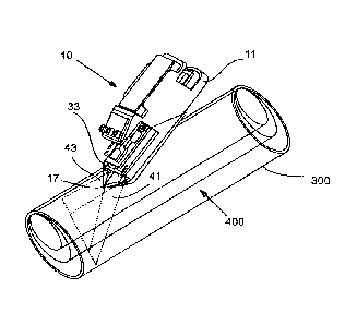
comprises two line laser diodes 38, 40 are mounted on respective sides of a
front part of
the base 16 and are directed forwardly (see Figure 5). A dispersion lens 71 is
mounted in
19
CA 02975500 2017-07-28
WO 2016/128820
PCT/1B2016/000106
front of each diode 38, 40 in order to allow the diode 38, 40 to emit a 60
beam of light 41,
43, with each beam being aligned with the pointer 17 (see also Figures 6 and
7). The base
16 defines a narrow slit 73 which allows the beams to together project a
straight line onto
the outer surface 400, when the diodes 38, 40 are oriented perpendicularly
thereto. If the
diodes 38, 40 are oriented at an acute angle relative to the outer surface
400, then, instead
of a straight line, an ellipse shape may be projected onto the surface 400.
The line/ellipse
shape can then be used to align the apparatus 10 with a structural feature
exposed on the
outer surface 400 of a borehole core 300.
[0086] The plane (generally indicated by reference numeral 500) defined by the
laser
beams 41, 43 can typically be determined by the vector which is at right
angles (normal) to
the plane. The 60 beams of light 41, 43 are typically designed to provide
maximum
coverage of the surface 400 of a core 300 in order to help allow accurate
recording of a
structural feature 600 (see Figures 17 and 18), irrespective of the angle of
the structural
feature 600 in relation to the core 300. The coverage generally ranges from
about 52% for
a B core (36.5mm diameter) to about 44% for an H core (63.5mm diameter).
[0087] An LED screen (not shown) is secured to the inner casing 12, above the
battery
pack 20. The LED screen is operatively connected to the Bluetooth
communication
arrangement 32 in order to allow a user to communicate with a computer 200 or
tablet 202
which forms part of the system 100. The LED screen can, for instance, be used
to input
parameters such as the depth and structure name (e.g. a planar or linear
structure).
[0088] The battery pack 20 can, for example, be a rechargeable NiCad battery
pack which
can provide about 6 hours of continuous use.
[0089] The capture and recording of data by way of the data-capturing
arrangement is
initiated through operation of the actuation means 28. In this embodiment, the
actuation
means 28 comprises one or more operating buttons. In the arrangement shown,
there are
three operating buttons 28.1-28.3. The button 28.1 is a referencing button
which is
configured to capture a reference orientation of the apparatus 10 when it is
placed against
CA 02975500 2017-07-28
WO 2016/128820
PCT/1B2016/000106
an outer surface 400 and oriented along a bottom-of-core ("BOC") line 106 (see
Figures
16, 17 and 18) which extends along the length of the core 300. A BOC line is a
term that is
well known in the industry and will therefore not be described in more detail.
The button
28.3 is a record button which can be used to capture a reading, or a number of
readings,
when the apparatus 10 is aligned with a structural feature 600. The button
28.2 a
multifunctional button in that it has a scroll function, as well as a single-
click and a double-
click function.
[0090] By using the single-click function, the computer 200 is instructed to
compute a best-
fit orientation of a particular structural feature 600 relative to the
borehole core 300
temporally. The computation includes determining a dip, dip direction and
strike for planar
features or a plunge and direction for linear features. It then plots the
structural feature 600
as a flashing point on a stereographic projection and as a plate or line on
orthographic
projection as well as calculate an apparent dip on a prescribed bearing. The
orthographic
projection is a representation in three dimensions of the borehole, together
with the planar
and linear structural features 600. A linear structural feature or lineation
can be
represented as a cylinder with an arrow indicating the direction of movement
on the slip
surface.
[00911 By using the double-click function, the computer 200 is instructed to
calculate and
save a number of parameters relating to the borehole and the structural
feature. The
computer 200 then saves the data, once a datum has been verified and saves the
geometric disposition to a data spread sheet. The calculated parameters may
include (but
is not limited to):
= down-hole depth (m) to where a mid-point of a structural feature 600
intersects a center of the core 300.
= borehole orientation: The azimuth and inclination of the borehole at that
depth.
= borehole co-ordinates (e.g. x, y and z coordinates) and vertical depth to
the
structure or geological contact.
21
CA 02975500 2017-07-28
WO 2016/128820
PCT/1B2016/000106
= real space orientation of the planar structure (e.g. the dip and dip
direction)
= alpha, beta and gamma angles of a structure used in the existing Internal
Core Angles method of determining the orientation. The alpha angle refers to
the angle between a vector pointing along the length of the core 300 and the
plane in which the planar feature extends.
= apparent dip or pitch of a structure in a predefined section line.
[0092] Typical data which is sent to the computer for further processing
includes:
= Quaternion data: The orientation of the apparatus 10 is sent through as a
unit
quaternion.
= Acceleration data: The raw acceleration data, in the three dimensional
directions (x,
y and x), is sent as a fraction of gravitational force (g).
= Gyroscope data: Data on the raw rotation around the three axes (x, y and
z).
= Optical sensor data: The movement of the optical sensor in two directions
(in
meters).
= Optical sensor status: The sensor identity, quality and status.
= The status as to whether any of the buttons have been pressed.
= Magnetic field
[0093] The apparatus 10 can be used in two different ways in order to measure
the
orientation of structural features 600 in a core 300.
[0094] The first method is referred to as the alignment method. This method
offers a
process of acquiring large structural data sets, primarily for stereographic
analysis where
the precise depth is not critical or even required. An example would be
measuring the
bedding planes to determine the direction of folding or measuring fore sets to
determine
the current direction or direction of flow. The process involves aligning the
unit using a flat
laser beam or the base of the device 10 with the structure.
22
CA 02975500 2017-07-28
WO 2016/128820
PCT/1B2016/000106
[0095] The normal method involves aligning the apparatus 10 with the structure
600 using
either the base or the planar laser beam 500 and acquiring at least four
recordings off the
surface 400 of the planar structure 600. The program statistically analyses
the recorded
measurements and calculates the 'plane of best fit' and determines the 'margin
of error'.
[0096] The method also offers a quick procedure that facilitates the rapid
acquisition of data
directly from the core 300 in a core tray. The program only requires one
alignment reading
per structure 600 before checking and saving. The alignment method utilises
the
gyroscope 30.1 and accelerometer 30.2 in order to determine/measure the
orientation of
the apparatus 10 once it has been aligned with a structural feature 600 by
using the laser
beams 41, 43. Alternatively, the edges 19.1, 19.2 of the lateral sides of the
base 16 can be
aligned with exposed structures (the alignment process will be described in
more detail
below). This method is convenient in gathering large data sets for
stereographic analysis in
situations where the exact depth of the structural feature 600 is irrelevant.
Routine
measuring of structural feature 600, particularly planar features such as
beddings,
foliations, fractures, faults, etc., can be undertaken by utilizing the laser
beams 41, 43
when the core 300 (more specifically a sample of the core 300 taken from a
borehole) is
positioned in a core tray. A technician should typically ensure that the core
samples are
properly pieced together and that the BOC line 106 is correctly aligned in the
tray. Drill
breaks and orientation discontinuities should be clearly demarcated as these
may have a
detrimental effect on the measurement of the structural feature 600.
[0097] The second method is referred to as the dimension method which uses the
optical
sensor 29 and the gyroscope 30.1 to measure a down-hole depth of the apparatus
10 and
to determine the angular displacement thereof, on the surface 400. This method
is
generally preferred when the accurate depth or precise geometric
disposition/orientation of
a structural feature 600, such as a major fault or fold axis, is critical.
Detailed and accurate
structural measurements, in particular the recording of linear features such
as slickenside
striae, rodding, boudins, or fold axes, may require the core 400 to be removed
from the
core tray and placed in a small V-bench to allow the apparatus 10 to be moved
over the
outer surface 400 of the core 300. To start recording, the apparatus 10 is
referenced to a
23
CA 02975500 2017-07-28
WO 2016/128820
PCT/1B2016/000106
depth mark line (see reference numeral 104 in Figures 17 and 19) parallel to
the BOC
orientation, i.e. by using the button 28.1. By simply sliding the apparatus 10
over the outer
surface 400 of the core 300 and aligning the point 17 with the position where
the structural
feature 600 intersects the outer surface 400 and recording several readings on
the same
feature 600, the apparatus 10, together with the computer 200, can determine
an estimated
orientation/disposition of the feature 600 in relation to the core 300.
[0098] A plane can be fitted in three dimensions, once three or more points on
the plane
are known.
[0099] Since the surface 400 of the core 300 forms a cylinder, if the
displacement along the
length of the core 300 can be kept separate from the displacement along/around
the
circumference thereof, the position/location of a particular point can be
obtained. Once
three or more points are measured in this way, relative to a fixed reference
point on the
orientation line 106, the orientation of a plane relative to the core 300 can
be calculated. If
more than three points are available, a plane of best fit can be derived. A
linear feature can
be derived by using two known points at which the lineation intersects the
surface 400. If
these points are measured repeatedly, the line of best fit can be derived and
the margin of
error is calculated.
[00100] The innate remnant magnetic disposition displayed by the core
300 can be
determined by using the magnetometer 30.4. Measuring the direction of the
remnant
magnetism of individual core samples from the same core 300 could be useful in
orientating/aligning the core samples correctly, such that the orientation
line 106 extends
across drill breaks (i.e. the direction of the remnant magnetism for the core
samples should
typically be in the same direction).
[00101] When the earth's magnetic field is subtracted and the residual
field measured
in proximity to the core 300 is correlated with the orientation, the
magnetisation of the core
300 can be extracted as a function of depth.
24
CA 02975500 2017-07-28
WO 2016/128820
PCT/1B2016/000106
[00102] All the data derived/calculated by the apparatus 10 is sent to
the computer
200 (or tablet 202) via the Bluetooth communication arrangement 32 for further
processing.
Specialised software is installed on the computer 200 (or similar
communications enabled
computing device) in order to provide a user with purposeful visual feedback
of the
structures 600 logged by the apparatus 10 on a computer (or other display)
screen.
[00103] The software typically integrates data received from various
sources, and
processes and combines the data with the structural feature data (received
from the
apparatus 10). Down-the-hole survey data, geological borehole logs,
geotechnical and
structural data are imported into the software by using Excel spreadsheets.
The data is
then processed, amalgamated with the structural feature data and can be
exported in
spreadsheet or text format into geological processing or mine planning
software programs.
One of the unique attributes of the software is the ability to depict planar
structural features
as planes plotted within the borehole in three-dimensional orthographic
projection (this will
be described in more detail below).
[00104] The software utilises a vector model to derive borehole
coordinates in three
dimensions and determine the plane geometry of a structural feature 600. The
apparatus
10, together with the software, has the ability to measure and calculate the
orientation of
structures accurately (even at relatively high core (Alpha and Beta) angles),
and to record
the orientation of non-penetrative linear structural features, such as fold
axes, crenulations.
The software can provide a user with a three-dimensional orientation of the
borehole and
structural feature 600 immediately (in real-time) at the time of logging (as
soon as the
necessary processing has been done as mentioned above). The orientation may be
displayed in orthographic and stereographic projection, thereby allowing a
user to audit and
verify the datum prior to saving.
[00105] The operational procedure involves; initially referencing the
apparatus 10
relative to the core 300 and BOC line 106 and then measuring the orientation
of the
structural feature 600 by either aligning the apparatus 10 with the structural
feature 600 or
by moving the apparatus 10 over the surface 400 and locating several points
where the
CA 02975500 2017-07-28
WO 2016/128820
PCT/1B2016/000106
structural feature 600 intersects the surface 400 by aligning the point 17
therewith.
Accurate measurements of a structural feature 600 can be obtained by recording
several
measurements of the feature 600 on the surface 400. The software then
statistically
analyses the data received from the apparatus 10 and produces a best-fit
estimation of the
orientation of the structural feature. This feature of the software can also
be used to
analyse the orientation of the same repetitive feature 400, such as bedding or
fore sets, to
calculate the best fit or average orientation of the measured structural
feature 600.
[00106] The software includes various software modules which are
described here
below:
Survey Module
[00107] Down-the-hole survey data can be entered manually on the
computer in a
single shot survey, or imported from any multi-shot survey tool. Once the data
is entered,
the coordinates are calculated and the projection of the borehole can
immediately be
viewed as a three-dimensional orthographic projection on a display screen. By
amending
the borehole azimuth and inclination cells, the software automatically
recalculates the down
hole coordinates and amends the borehole three-dimensional plot accordingly.
The
software allows a user to zoom in and out, scroll up and down the borehole,
and to
freehand pan and rotate the view angle.
Geology Module
[00108] Existing borehole logs, together with the structural feature
data received from
the apparatus 10, can be imported into certain software parameters, such as
depth,
lithological unit, description and a unique identifiable colour which can be
imported directly
from an Excel spreadsheet, as would be understood by a person skilled in the
art.
Stereographic Projection Module
[00109] The orientation of structural features 400 is automatically
plotted by the
software in stereographic projection, with various options available. Each
type of structure
is displayed in a unique colour for easy identification and a user/technician
has the option
26
CA 02975500 2017-07-28
WO 2016/128820
PCT/1B2016/000106
to display specific structure types selectively. The data can be exported to
recognized
structural analytical programs. In this regard please see Figure 10.
Orthographic Projection Module
[00110] Referring now to Figures 11-13, the orientation of a structural
feature 400 is
also automatically determined and plotted to a three-dimensional orthographic
projection.
Planar structures, with lines depicting strike and dip direction are projected
as rectangular
plates on the planar surface. Linear features, displayed as small rods and
structures, such
as faults where the direction of movement could be determined, are plotted as
arrows
showing the orientation and direction of movement. The software allows a user
to zoom
in/out, scroll up and down the borehole and to freehand change and rotate the
view angle.
The background can be annotated with various grid overlays, including a
coordinated
orthographic three-dimensional grid over the borehole projection, or a
circular grid with
compass bearing and the inclination of the borehole at that depth. Scrolling
up and down
the borehole changes the position of the grid down the borehole. By scrolling
up and down
the borehole, the grid can be positioned such that individual structures plots
in the centre of
the grid, the strike and dip directions and can be physically
measured/recorded off the grid
if required.
[00111] The strike and dip are depicted as white or black lines on the
animated plane
of the structural feature 600. The software provides an option to change the
colour and size
of individual structural plots. The ability to increase the size of the
plotted planes is useful in
extending the size and projecting major structures. These structure planes can
be enlarged
to provide the user with an idea of where the structure should be running
under ground.
This model can then be imported directly into a user's mine modelling software
where this
enlarged structure can be inspected throughout the mining area.
Data File Module
[00112] This is a multi-functional module. The primary function is to
provide a
database for the storage of all the structural feature recordings and
calculations. The
database can be exported to an Excel file. The secondary function serves to
edit and
27
CA 02975500 2017-07-28
WO 2016/128820
PCT/1B2016/000106
correct individual structural feature records. Certain specific cell values
can be amended or
changed in order to adjust the calculated results automatically. On saving the
input
parameters, up to 16 different parameters are calculated and saved to a data
file. In this
regard, reference is specifically made to Figure 14.
[00113] The following parameters may, for example, be calculated:
Calculated parameters pertaining to a borehole:
= down-hole depth (in meters) to where a mid-point of the structural
feature
intersects a center of the core 300.
= borehole orientation, azimuth and inclination at the down-hole depth.
= borehole co-ordinates (x, y, and z) and vertical depth to the structural
feature.
Calculated parameters pertaining to planar features:
= real space orientation of the feature, dip and dip direction.
= alpha and beta angles of the feature used in the Internal Core Angles
method of
determining the orientation.
= apparent dip of the planar feature in a predefined section line.
Calculated parameters pertaining to linear features:
= down-hole depth (in meters) to where a mid-point of the linear feature
intersects
the center of the core.
= orientation represented by the plunge and trend of the linear feature:
o trend - direction in which a linear feature plunges.
o plunge - angle between the lineation and the horizontal.
o pitch of the lineation - being the angle between the feature and a
predefined
section line.
= gamma and/or delta angles of the structure used in the Internal Core
Angles
method.
= Misfit - the angular difference between the lineation and a planar feature
in which
28
CA 02975500 2017-07-28
WO 2016/128820
PCT/1B2016/000106
it occurs.
Procedure for recording structural features
[00114] Here below follows an example of how a particular structural
feature may be
recorded by the system 100:
i. Initiate a new log by clearing existing data in the survey module.
ii. Import down-the-hole survey data into the survey module. Should the
actual down-
the-hole survey data not be available, then the borehole depth and the initial
estimated borehole survey, azimuth and inclination can be inserted manually by
using the computer 200. The actual borehole survey can be imported at a later
stage and the orientation of all the structural recordings will then be
automatically
adjusted/amended. The geometric disposition/orientation of structures is
computed
relative to the borehole survey.
iii. In order to capture structural feature data, an "input structure"
screen is opened by
selecting the appropriate option at the top of a user interface screen on the
computer 200.
Input Structure Screen
The input structure screen displays a number of cells which allows a user to
enter
information regarding the borehole/borehole core.
A visual orthographic 3D projection of the orientation of the apparatus 10
relative to
the core 300 is displayed. The display provides an indication that the
apparatus 10 is
working properly and is connected wirelessly to the computer 200.
The following information may, for example, be entered by a user:
= The downhole depth to the recording. The depth may be inserted
manually on the computer or inserted using the scroll function of the
29
CA 02975500 2017-07-28
WO 2016/128820
PCT/1B2016/000106
button 28.2 on the apparatus. The options may be a planar structure,
linear structure or a combination thereof.
= The technique/method used to record the structure. The options may be:
i. The alignment method; or
ii. The dimension method.
These two methods will be described in more detail below.
= A unique name to identify the structure.
= Margin of Error: This allows a user to define an acceptable margin of
error
level.
iv. Insert the borehole details:
= Units of measure (either metric or Imperial).
= Core diameter (the most common core sizes are displayed in a drop-down
menu on the user interface).
= Top -or Bottom-Of-Core orientation.
v. In a depth field), insert the down-hole depth at which the apparatus 10
is
referenced.\
vi. Method: Select the routine used to record the structural feature 600:
The program statistically determines the Plane of Best Fit (PBF) and
calculates the
margin of error for a desired degree of confidence, thereby determining the
number
of readings to be taken on a single structure.
The program determines the offset distances on the left and right-hand side of
the
core 300 from the position where the trace of the structural feature
intersects the
orientation line. This enables the user to verify and check the validity of
the
recording.
CA 02975500 2017-07-28
WO 2016/128820
PCT/1B2016/000106
The program determines the real space geometric orientation of the planar
structure,
i.e. the dip and dip direction, and the plunge and plunge direction for linear
structures in relation to the orientation line. The geometric disposition of
the
orientation line is derived from the data imported into the survey module.
The margin of error is determined by the irregularity of the structure and the
accuracy/precision of the measurement recordings.
The program utilizes the collar coordinates, x, y, and z together with the
down-hole
survey data to determine the geometric orientation and coordinates of the mid
point
where the structural element intersects the middle of the core.
Alignment Method
[00115]
This is a relatively quick and easy method of measuring structures in
core
samples by simply aligning the apparatus with the structure.
[00116]
The apparatus 10 is firstly referenced along the orientation line 106
and then
moved in order to align the apparatus 10 with the structural feature 600. The
apparatus 10
can be aligned by using either the laser beams 41, 43 or the edges 19.1, 19.2
of the lateral
sides of the base 16. This method is a rapid data acquisition method to
collate structural
data for stereographic analysis. Multiple structures can be recorded from a
single
reference.
o
Planar structures: Either the base 16 of the apparatus 10, or the laser
beams 41,
43 can be used to align the apparatus 10 with the structural feature 600,
depending on whether the structure 600 is exposed on the outer surface 400 of
the core 300. Figure 22 show an example of how an apparatus 10 can be first
be referenced (see reference numeral 10a) and thereafter be oriented such that
the laser beams 41, 43 project along a surface of a planar feature (i.e. to
align
the beams 41, 43 with the surface), to thereby align the apparatus 10
therewith
(see reference numeral 10b). By clicking the record button 28.3, the
orientation
31
CA 02975500 2017-07-28
WO 2016/128820
PCT/1B2016/000106
of the feature 600 is measured. By single clicking the button 28.2, the
computer
200 temporarily determines the orientation of the feature 600 and plots the
feature 600 as a flashing (blinking) point on a stereogram and a three-
dimensional orthographic projection. Once the results have been validated, it
can be saved on a database by double clicking the button 28.2. In certain
circumstances, more accurate results can be obtained by taking several
readings by aligning the apparatus 10 at varying positions on the feature 600,
before clicking the button 28.2.
o The procedure for recording unexposed planar structures using the Alignment
method may be summarised as follows:
= The apparatus 10 is initially referenced by placing it with the point 17
positioned anywhere on the core 300 where the vertical orientation plane
intersects the surface 400 of the core 300. The reference button is then
depressed to initialize the registration. The laser beam/ diodes 38, 40 turns
on automatically once the alignment method is selected and the apparatus 10
can then be lifted off the core surface 400.
= The point 17 is then positioned at any point where the trace of the
planar
structure 600 outcrops on the core surface 400. By turning and lifting the
apparatus the laser beams 41, 43 can be aligned with the outcrop of the
structure 600 on the core surface 400. The record button 28.1 is then
depressed. Any number of recordings can be taken along the outcrop of the
structure 600 on the core surface 400.
= The program determines the accuracy and reliability of the measurements
by
calculating the mean and standard deviation of the measurement.
= Once the operator is satisfied with the reliability and number of recordings
a
"Check" button is depressed and the orientation of the structure is determined
and displayed as a flashing point on the Stereographic projection. When the
operator is satisfied with the projection of the structure depressing a "save"
button provided on a user interface screen, stores the data to the data file.
32
CA 02975500 2017-07-28
WO 2016/128820
PCT/1B2016/000106
o Lineation (Linear Inertia): The edges 19.1, 19.2 of the lateral sides of
the base
16 can be used to align the apparatus 10 with the micro structural features
600,
otherwise the procedure is the same as for the planar structures. It should be
noted that only exposed lineations can be measured using this method.
o In the procedure for recording linear structures using the Alignment
method, the
base or the sides of the apparatus can be used to record the orientation of
planar or linear elements exposed on surfaces of breaks within the core.
o A combination of planar and liner structures can be recorded by combining
the
procedures set out above.
Dimension Method
[00117]
The apparatus is firstly/initially referenced at a specific depth along
the
vertical orientation line 106 (see reference numeral 10c in Figure 23, as well
as Figure 25
(see specifically the position indicated by reference numeral 501)). The
apparatus 10 is
then moved in close proximity along the surface 400 to record various
positions on the
feature 600 exposed on the surface 400 (see reference numerals 10d-f in Figure
23 which
refer to various positions of the apparatus 10 in which recordings can be
taken (in addition,
also see the positions indicated by reference numerals 502-504 in Figure 25).
Multiple
readings are required for an individual structure recording. Planar
structures, linear
structures, or a combination thereof, can be recorded. For lineations, only
two recordings
are required to determine the orientation of the structure. In this regard,
please see Figures
24 and 27 in which reference numerals 601 and 602 refer to two positions where
recordings can, for instance, be taken in order to determine the orientation
of a lineation.
vii. Define the unique identifying structural feature identification, such
as bedding,
foliation, cleavage, or Fl.
viii. Reference the apparatus 10 by placing it on the core with the point
17 positioned on
the BOC line 106. For the quick alignment method: the apparatus 10 only
requires to
33
CA 02975500 2017-07-28
WO 2016/128820
PCT/1B2016/000106
be referenced once if the structural features are recorded in a core tray. For
the
dimension method, the apparatus 10 should be referenced on the BOC line 106
with
the point 17 positioned at a specific depth.
ix. Structure identification: Select a unique name for the structure such
as cleavage 1,
bedding, Fl fold, etc.
x. Measurements: Each time the record button 28.3 is selected, the software
calculates the x, y and z vector values and determines the mean and standard
deviation. These values determine the accuracy and reliability of the data.
Operational procedures
[00115] The system 100 uses various techniques for recording the
orientation of
structural features 400 in cores 300. To undertake a structural analysis of a
core 300 and in
situations where depth is not an issue, the structural features 600 can be
recorded with the
core 300 in a core tray. The laser beams 41, 43 can simply be aligned with the
outcropping
trace of the planar feature on the surface 400. For a more detailed analysis,
the core 300
can be placed into a small V-bench and the apparatus 10 can then be moved
along the
surface 400 and positioned where the structural feature 600 is exposed on the
surface 400.
Stereographic analysis
[00116] Sterographic projections can be used to verify and check the
integrity of the
data prior to saving.
[00117] After all the relevant orientation data of the apparatus 10 has
been recorded
for a particular structure, the data is processed by the computer 200 and
plotted
stereographically The processed data can also be exported as text or in
spreadsheet
format into other structural data processing programs.
Orthographic analysis
34
CA 02975500 2017-07-28
WO 2016/128820
PCT/1B2016/000106
[00118] Once the borehole survey details have been entered or
imported, together
with the core size/diameter, the borehole is displayed in three dimensions in
the
orthographic section. The appropriate tab can then be selected on the
interface screen in
order to enter a data-capture mode in which the apparatus 10 can be used to
capture data
on the structural features 600 present in a core 300. The core 300 is
typically positioned in
a core tray (which should be carefully pieced together in order to ensure
accurate results).
The logging procedures generally require firstly, for the apparatus 10 to be
referenced (at a
specific reference point) and orientated relative to the BOC orientation line
106. This is
followed by various techniques for recording the structural features 600, be
it planar or
linear, and then final corroborating by returning the apparatus 10 to the
original reference
point. This way the device is able to re-calibrate itself and in turn certify
and confirm the
measurements taken prior to the re-calibration, by going back to a known
point. The
methods whereby the optical sensor 29 is not used, and reliance is only placed
on the
gyroscope 30.1 and accelerometer 30.2 to measure the orientation (or
direction) of the
structural feature 400, are less accurate when compared to using the optical
sensor 29 as
well. The error in the angle of the structural feature may be up to 5 degrees.
The more
accurate method requires the apparatus 10 to remain in contact with the
surface 400 at all
times. In this instance it is preferable to place the core samples on a small
V-bench to
acquire greater access to the core 300.
Referencing
[00119] Placing the apparatus 10 on the core 300 where the vertical
orientation plane
intersects the upper or lower surface of the core 300, commonly referred to as
the Top Of
Core Line (TOC) or Bottom of Core line (BOC) line 106 and pressing the
referencing button
28.1, initially aligns/references the apparatus 10 in relation to the core
300. This position
can be referred to as the reference point/position. The precise geometric
disposition of the
orientation line can be determined by using commercially available down-the-
hole
gyroscopic survey devices.
35
CA 02975500 2017-07-28
WO 2016/128820
PCT/1B2016/000106
[00120]
The disposition of the vertical orientation plane can be determined
using
commercially available down-the-hole orientation instruments.
[00121]
Accurate measurements of a structural feature 600 are obtained by
recording
several measurements of the feature 600 on the surface 400 of the core 300.
The software
statistically analyses the data and produces the best fit estimation of the
orientation of the
structural feature 600. This feature of the software can also be used to
analyse the
orientation of the same repetitive structural feature 600, such as bedding or
fore sets
(which are spaced along the length of the core). The program will calculate
the best fit or
average orientation of the measured structural features 600. Every section of
continuous
orientated core should be referenced and co-ordinated by the apparatus 10.
Procedure for recording planar structural features
i.
Reference the apparatus 10 by placing it on the core 300 parallel to the BOC
orientation line 106, with the point 17 positioned over a particular depth
mark
generally indicated by reference numeral 104 in Figures 16 and 17. Press the
referencing button 28.1 and enter the depth into the computer 200 (or tablet
202).
ii.
Align the apparatus 10 with a plane 102 Of the structural feature 600
(see Figures 16
and 17). This can be done in two ways:
a. For open/exposed planar features, place the apparatus 10 with the guide
formations 22.1, 22.2 resting on the plane 102, press the button 28.3 to
record the reading. For more accurate recordings a number of readings can
be entered at different positions on the plane 102.
b. For unexposed planar features, place the point 17 on any position where a
trace of the structural feature is exposed/outcrops on the surface 400 of the
core 300, the laser beam/ diodes 38, 40 turn on/off automatically once the
alignment method is selected, and rotate the apparatus 10 until the laser
beams 41, 43 project along the trace of the structure. Then, press the record
button 28.3.
36
CA 02975500 2017-07-28
WO 2016/128820
PCT/1B2016/000106
For more accurate planar recordings, after referencing, the apparatus 10 can
be
moved along the surface 400 such that the point 17 is placed at a position
where the
feature 600 intersects the surface 400. The button 28.3 is then pressed. (It
should
be noted that this is not the so-called Top of Ellipse' as defined in the
Internal Core
Angles Method.) Repeat this on at least four different points along the
feature trace.
It is imperative for the optical sensor 29 to work properly and that the
apparatus 10
remains on the core surface 400 at all times. The apparatus 10 should be
returned
to the original reference point to complete the recording.
Linear Structures
[00122] As mentioned above, the apparatus 10 utilises the optical
sensor 29 to record
the real-space orientation of linear structural features 600 (e.g. slickenside
striae, fold axes,
crenulations, mullions and deformed pebbles) in cores accurately. Even the so-
called Line
of Intersection (L01) between two planar structures can be determined using
the apparatus
10. To be able to take readings, the core samples should preferably be removed
from the
core tray and placed on a small V-bench. The measurements are made directly
off the
surface 400 and are accurate even for structural features at high core angles,
i.e.at angles
greater than 60 from the plane to the core axis. Detailed and comprehensive
micro-
structural analyses of individual core samples may also be performed.
Procedure for recording linear structural features
[00123] Reference is now specifically made to Figure 18.
i. The apparatus 10 by placing it on the surface 400 of the core 300
parallel to the
BOC orientation line 106 with the point 17 positioned over a particular depth
mark.
Press the button 28.1 and enter the depth into the computer 200.
ii. With the apparatus 10 remaining in contact with the surface 400 at
all times, move
the apparatus along the surface 400 and place the point 17 at the position
where the
feature 600 intersects the surface 400 (see Si). Then press the button 28.3.
37
CA 02975500 2017-07-28
WO 2016/128820
PCT/1B2016/000106
iii. Move the apparatus over the surface 400 to another position where
the linear
feature intersects the surface 400 (see S2). Again press the button 28.3. (It
should
be noted that either end of the linear feature, S1 or S2, can be used as the
initial
reference point (in step ii)).
iv. A number of structures can be logged in this way. The process ends once
the
apparatus 10 is returned to the original reference point captured in step i.
[00124]
If there is any evidence of displacement (i.e. slickensides), a side of
the
apparatus 10 can also be used as a reference to orientate the tool.
[00125]
In situations where the sense of shear (SOS) can be determined from
structures, e.g. with slickensides on a fault surface, the direction of
displacement can be
recorded and input into the program, so that a detailed kinematic analysis of
the core can
be conducted. The program plots the directional linear feature as an arrow on
the plate
representing the planar structure.
Magnetic susceptibility recordings
i. Reference the apparatus 10 by placing it on the surface 400 of the core
300 parallel
to the BOC orientation line 106 with the point 17 positioned over a particular
depth
mark. Press the referencing button 28.1 and enter the depth into the computer
200.
ii. With the apparatus 10 remaining in contact with the surface 400 at all
times move
the apparatus 10 along the surface 400 and place the point 17 at the position
where
a magnetic reading needs to be taken and press the button 28.3.
iii. Move the apparatus 10 over the surface 400 and take two additional
readings on
either side of the core 300 at the same depth as the position mentioned in
step ii.
iv. The captured data is sent directly to the software (which is
installed on the computer
200) which then determines the direction of the remnant magnetism.
[00126] The apparatus 10 is a geotechnical handheld sampling tool which is
capable
of measuring and computing the geometrical disposition of planar and linear
structural
38
CA 02975500 2017-07-28
WO 2016/128820
PCT/1B2016/000106
features exhibited in orientated borehole core samples. The Inventors believe
that the
system 100 and apparatus 10 simplify and enhance geotechnical mapping of
structures in
borehole cores.
[00127] The system 100 and apparatus 10 also offer an interactive and
quantitative
technique for logging structures and generally do not require specialized
training or an in-
depth understanding of stereographic analysis. Down-hole surveys and
geological and
structural logs can be imported, processed and then exported in spreadsheet or
text format
into geologic processing or mine planning software programs. Data so acquired
may
alternatively, or additionally, be transferred to cloud-based storage.
[00128] The apparatus 10 has the capability of recording the
orientation of structural
features 600 in core samples directly off the core 300. By clicking once on
the depth along
the orientation line 106 and then at three positions on the structural plane
(for a planar
feature) or at just two positions (for a linear feature), the system 10 can
immediately (in
real-time) calculate and display the orientation of the feature 600 on a
computer 200 or
tablet 202. The real space orientation of the structural feature 600 is
immediately presented
to the geologist in three-dimensional orthographic or stereographic projection
at the time of
logging the core 300.
[00129] The invention described above has a number of advantages over
existing
systems. One of the main advantages is that the 'real space' orientations of
structural
elements in core samples are automatically calculated and presented in 3D
orthographic
projection to the geologist at the time of logging (i.e. there is no
transposing or
recalculations). Individual datum points can also be checked and verified
prior to input. The
invention is also relatively simple in that the measurements are recorded
directly off the
surface 400 of the core 300 and does not require the use of measuring
templates. There is
also generally no rounding of the estimated measurements. Borehole survey data
together
with geotechnical/geological borehole logs can also be imported and/or
exported in
spreadsheet or text format, as well as optionally being transferred to cloud
based storage.
The accurate recording of structures and measurements are not reliant on the
39
CA 02975500 2017-07-28
WO 2016/128820
PCT/1B2016/000106
determination of the ellipse, as in the Internal Angles method. Even
structures at high alpha
angles can be accurately determined.
[00130] The Inventors also believe that the invention provides a
relatively simple
measuring technique. The invention simply utilizes the down-hole depth and the
offset
along the left and right-hand side of the core 300 to determine the
orientation of the planar
structures. Linear structures require the offsets combined with the rotation
angle that can
be recorded using a simple template.
[00131] The invention is also relatively inexpensive, since no expensive
goniometers
are used. The invention also saves time since the capturing of the data is
faster.
[00132] In the first embodiment, the beam-forming arrangement 35
comprises two
line laser diodes 38, 40 are mounted on respective sides of a front part of
the base 16
Other beam-forming arrangement are, of course possible, one example of which
is
featured in a second embodiment of apparatus 10
[00133] Referring now to Figures 28 to 30, there is shown
(schematically) a second
embodiment of apparatus 10. The second embodiment of apparatus 10 is similar
in many
respects to the first embodiment described and illustrated previously, and so
corresponding
reference numerals are used to denote similar parts.
[00134] In this second embodiment, the beam-forming arrangement 35
comprises a
centrally located laser module 82 and associated dispersion lens 84 operable
to emit a
beam of light for projection onto the surface 400 of the core 300 to provide a
visual
indication on the surface for alignment purposes. In the arrangement shown,
the
dispersion lens 84 comprises a Powell lens, or other similar lens, capable of
providing a
more evenly lit indication line and a generally wider angle of projection of
the beam. In this
embodiment, the beam width is about 120 degrees. An advantage of the
arrangement of
this second embodiment in comparison to the first embodiment is that there is
a single
CA 02975500 2017-07-28
WO 2016/128820
PCT/1B2016/000106
beam emitted, thereby avoiding the need to align two separate beams on opposed
sides of
the apparatus 10 with the pointer 17.
[00135] It should be appreciated that the scope of the invention is
not limited to the
scope of the two embodiments described. Modifications and variations such as
would be
apparent to the skilled addressee are considered to fall within the scope of
the present
invention.
[00136] The present disclosure is provided to explain in an enabling
fashion the best
modes of making and using various embodiments in accordance with the present
invention. The disclosure is further offered to enhance an understanding and
appreciation
for the invention principles and advantages thereof, rather than to limit in
any manner the
invention. While a preferred embodiment of the invention has been described
and
illustrated, it is clear that the invention is not so limited. Numerous
modifications, changes,
variations, substitutions, and equivalents will occur to those skilled in the
art having the
benefit of this disclosure without departing from the spirit and scope of the
present
invention as defined by the following claims.
[00137] Reference to positional descriptions, such as "inner",
"outer", "upper", "lower",
"top" and "bottom", are to be taken in context of the embodiments depicted in
the drawings,
and are not to be taken as limiting the invention to the literal
interpretation of the term but
rather as would be understood by the skilled addressee.
[00138] Additionally, where the terms "system", "device", and
"apparatus" are used in
the context of the invention, they are to be understood as including reference
to any group
of functionally related or interacting, interrelated, interdependent or
associated components
or elements that may be located in proximity to, separate from, integrated
with, or discrete
from, each other.
41
CA 02975500 2017-07-28
WO 2016/128820
PCT/1B2016/000106
[00139] Throughout this specification, unless the context requires
otherwise, the word
"comprise" or variations such as "comprises" or "comprising", will be
understood to imply
the inclusion of a stated integer or group of integers but not the exclusion
of any other
integer or group of integers.
10
20
42