Note: Descriptions are shown in the official language in which they were submitted.
CA 02976348 2017-08-10
WO 2016/130755 PCT/US2016/017468
TITLE
Method and System for Transportation Resource Grouping and Reallocation
RELATED APPLICATIONS
[0001] This application claims the benefit of priority to U.S. Provisional
Application
No. 62/114,956, titled "Transportation Resource Grouping and Reallocation"
filed
February 11, 2015, and to U.S. Application No. 15/040,441, titled "Method and
System for Transportation Resource Grouping and Reallocation", filed February
10,
2016, the entire contents of both of which are hereby incorporated by
reference.
BACKGROUND
[0002] The increasing use of electric automobiles has led to declining fuel
tax
revenues, with no reduction in throughput on public roadways. Increased use of
roadway charges such as bridge and road tolls may offset a portion of
diminished
fuel tax income, but motorists may be reluctant to use pay-for-use roadways
due to
traffic congestion associated with toll plazas. Thus, parts of the roadway go
largely
unused due to the perceived risk of delay and inconvenience associated with
toll
roads and bridges. Improved methods and solutions for dynamically allocating
roadway resources (e.g., use of particular lanes at particular times of day,
etc.)
throughout a transportation system for access and use by motorists will be
beneficial
to roadway owners, service providers, and to the motorists themselves.
SUMMARY
[0003] The various aspects include dynamic transportation resource arbitrage
(DTRA) methods, which may include generating granular vehicular occupancy
opportunity elements/units that each identify an amount of a transportation
resource
that is offered for allocation and use by travelers with respect to an area,
and
offering the vehicular occupancy opportunity elements/units for purchase,
lease, or
1
CA 02976348 2017-08-10
WO 2016/130755 PCT/US2016/017468
trade on a commodities exchange. In an aspect, generating the granular
vehicular
occupancy opportunity elements/units includes generating vehicular occupancy
opportunity elements/units that use a universal standard to identify,
quantify,
measure, and/or represent the transportation resource.
[0004] In a further aspect, generating the granular vehicular occupancy
opportunity
elements/units may include generating vehicular occupancy opportunity
elements/units that identify the transportation resource in a standard format,
structure, or unit that is readily understood by the trading community. In a
further
aspect, generating the granular vehicular occupancy opportunity elements/units
includes generating vehicular occupancy opportunity elements/units that
include or
provide a common reference point against which other vehicular occupancy
opportunity elements/units and transportation resources may be compared. In an
aspect, the method may include comparing two or more vehicular occupancy
opportunity elements/units that represent different resource offerings from
different
lessor parties to determine the relative economic value of the offered amounts
of
transportation resource. In a further aspect, generating the granular
vehicular
occupancy opportunity elements/units may include generating vehicular
occupancy
opportunity elements/units that define an amount of distance along a section
of
transportation grid in relation to a geographic area encompassing one cubic
meter.
In a further aspect, generating the granular vehicular occupancy opportunity
elements/units may include generating vehicular occupancy opportunity
elements/units that may be combined to cover a precise location or area.
[0005] In an aspect, the method may include combining the vehicular occupancy
opportunity elements/units to cover an area that encompasses a highway,
bridge,
navigation path, waterway, or air traffic corridor. In an aspect, the method
may
include receiving bids for the offered vehicular occupancy opportunity
element/unit,
determining one or more winning bids associated with registered users,
submitting
the winning bids to a charging system for payment, and allocating the
vehicular
2
CA 02976348 2017-08-10
WO 2016/130755 PCT/US2016/017468
occupancy opportunity elements/units to users having winning bids. In a
further
aspect, offering the vehicular occupancy opportunity elements/units for
purchase,
lease, or trade on a commodities exchange may include grouping the vehicular
occupancy opportunity elements/units to form a polygon, and offering the group
of
vehicular occupancy opportunity elements/units for purchase, lease, or trade
on the
commodities exchange.
[0006] Further aspects include a server computing device that includes a
memory
and a processor coupled to the memory, in which the processor is configured
with
processor-executable instructions to perform operations that include
generating
granular vehicular occupancy opportunity elements/units that each identify an
amount of a transportation resource that is offered for allocation and use by
travelers
with respect to an area, and offering the vehicular occupancy opportunity
elements/units for purchase, lease, or trade on a commodities exchange. In an
aspect, the processor may be configured with processor-executable instructions
to
perform operations such that generating the granular vehicular occupancy
opportunity elements/units includes generating vehicular occupancy opportunity
elements/units that use a universal standard to identify, quantify, measure,
and/or
represent the transportation resource.
[0007] In a further aspect, the processor may be configured with processor-
executable instructions to perform operations such that generating the
granular
vehicular occupancy opportunity elements/units includes generating vehicular
occupancy opportunity elements/units that identify the transportation resource
in a
standard format, structure, or unit that is readily understood by the trading
community. In a further aspect, the processor may be configured with processor-
executable instructions to perform operations such that generating the
granular
vehicular occupancy opportunity elements/units includes generating vehicular
occupancy opportunity elements/units that include or provide a common
reference
point against which other vehicular occupancy opportunity elements/units and
3
CA 02976348 2017-08-10
WO 2016/130755 PCT/US2016/017468
transportation resources may be compared. In a further aspect, the processor
may be
configured with processor-executable instructions to perform operations
further
including comparing two or more vehicular occupancy opportunity elements/units
that represent different resource offerings from different lessor parties to
determine
the relative economic value of the offered amounts of transportation resource.
In a
further aspect, the processor may be configured with processor-executable
instructions to perform operations such that generating the granular vehicular
occupancy opportunity elements/units includes generating vehicular occupancy
opportunity elements/units that define an amount of distance along a section
of
transportation grid in relation to a geographic area encompassing one cubic
meter.
In a further aspect, the processor may be configured with processor-executable
instructions to perform operations such that generating the granular vehicular
occupancy opportunity elements/units includes generating vehicular occupancy
opportunity elements/units that may be combined to cover a precise location or
area.
[0008] In a further aspect, the processor may be configured with processor-
executable instructions to perform operations further including combining the
vehicular occupancy opportunity elements/units to cover an area that
encompasses a
highway, bridge, navigation path, waterway, or air traffic corridor. In a
further
aspect, the processor may be configured with processor-executable instructions
to
perform operations further including receiving bids for the offered vehicular
occupancy opportunity element/unit, determining one or more winning bids
associated with registered users, submitting the winning bids to a charging
system
for payment, and allocating the vehicular occupancy opportunity elements/units
to
users having winning bids. In a further aspect, the processor may be
configured
with processor-executable instructions to perform operations such that
offering the
vehicular occupancy opportunity elements/units for purchase, lease, or trade
on a
commodities exchange includes grouping the vehicular occupancy opportunity
elements/units to form a polygon, and offering the group of vehicular
occupancy
4
CA 02976348 2017-08-10
WO 2016/130755 PCT/US2016/017468
opportunity elements/units for purchase, lease, or trade on the commodities
exchange. Further aspects include a non-transitory computer readable storage
medium having stored thereon processor-executable software instructions
configured to cause a processor to perform operations including generating
granular
vehicular occupancy opportunity elements/units that each identify an amount of
a
transportation resource that is offered for allocation and use by travelers
with respect
to an area, and offering the vehicular occupancy opportunity elements/units
for
purchase, lease, or trade on a commodities exchange. In an aspect, the stored
processor-executable software instructions may be configured to cause a
processor
to perform operations such that generating the granular vehicular occupancy
opportunity elements/units includes generating vehicular occupancy opportunity
elements/units that use a universal standard to identify, quantify, measure,
and/or
represent the transportation resource.
[0009] In a further aspect, the stored processor-executable software
instructions may
be configured to cause a processor to perform operations such that generating
the
granular vehicular occupancy opportunity elements/units includes generating
vehicular occupancy opportunity elements/units that identify the
transportation
resource in a standard format, structure, or unit that is readily understood
by the
trading community. In a further aspect, the stored processor-executable
software
instructions may be configured to cause a processor to perform operations such
that
generating the granular vehicular occupancy opportunity elements/units
includes
generating vehicular occupancy opportunity elements/units that include or
provide a
common reference point against which other vehicular occupancy opportunity
elements/units and transportation resources may be compared. In a further
aspect,
the stored processor-executable software instructions may be configured to
cause a
processor to perform operations further including comparing two or more
vehicular
occupancy opportunity elements/units that represent different resource
offerings
from different lessor parties to determine the relative economic value of the
offered
CA 02976348 2017-08-10
WO 2016/130755 PCT/US2016/017468
amounts of transportation resource. In a further aspect, the stored processor-
executable software instructions may be configured to cause a processor to
perform
operations such that generating the granular vehicular occupancy opportunity
elements/units includes generating vehicular occupancy opportunity
elements/units
that define an amount of distance along a section of transportation grid in
relation to
a geographic area encompassing one cubic meter. In a further aspect, the
stored
processor-executable software instructions may be configured to cause a
processor
to perform operations such that generating the granular vehicular occupancy
opportunity elements/units includes generating vehicular occupancy opportunity
elements/units that may be combined to cover a precise location or area.
100101 In a further aspect, the stored processor-executable software
instructions may
be configured to cause a processor to perform operations that further include
combining the vehicular occupancy opportunity elements/units to cover an area
that
encompasses a highway, bridge, navigation path, waterway, or air traffic
corridor.
In a further aspect, the stored processor-executable software instructions may
be
configured to cause a processor to perform operations that further include
receiving
bids for the offered vehicular occupancy opportunity element/unit, determining
one
or more winning bids associated with registered users, submitting the winning
bids
to a charging system for payment, and allocating the vehicular occupancy
opportunity elements/units to users having winning bids. In a further aspect,
the
stored processor-executable software instructions may be configured to cause a
processor to perform operations such that offering the vehicular occupancy
opportunity elements/units for purchase, lease, or trade on a commodities
exchange
includes grouping the vehicular occupancy opportunity elements/units to form a
polygon, and offering the group of vehicular occupancy opportunity
elements/units
for purchase, lease, or trade on the commodities exchange.
BRIEF DESCRIPTION OF THE DRAWINGS
6
CA 02976348 2017-08-10
WO 2016/130755 PCT/US2016/017468
[0011] The accompanying drawings, which are incorporated herein and constitute
part of this specification, illustrate exemplary embodiments of the invention,
and,
together with the general description given above and the detailed description
given
below, serve to explain features of the invention.
100121 FIGs. lA through 1C are system block diagrams illustrating various
logical
and functions components and communication links in communication systems that
may be used to implement the various embodiments.
[0013] FIG. 2 is a process flow diagram illustrating a dynamic transportation
resources arbitrage (DTRA) method of allocating the rights for the access and
use of
a transportation resource that is associated with a vehicular occupancy
opportunity
element/unit or group of vehicular occupancy opportunity elements/units in
accordance with an embodiment.
[0014] FIGs. 3A through 12 illustrate various shapes, characteristics,
features, and
data fields that may be associated with a vehicular occupancy opportunity
element/unit or vehicular occupancy opportunity element/unit grouping in
accordance with the various embodiments.
[0015] FIG. 13 is a component block diagram of an example wireless device
suitable
for use with the various embodiments.
100161 FIG. 14 is a component block diagram of a server suitable for use with
an
embodiment.
[0017] FIG. 15 is a corridor configuration vehicular occupancy opportunity
element/unit grouping in accordance with the various embodiments.
[0018] FIG. 16 is a block diagram illustrating components in an example system
that
is suitable for performing DTRA operations for allocating the rights for the
access
and use of a transportation resource that is associated with a vehicular
occupancy
7
CA 02976348 2017-08-10
WO 2016/130755 PCT/US2016/017468
opportunity element/unit or group of vehicular occupancy opportunity
elements/units in accordance with an embodiment.
[0019] FIG. 17 is a block diagram illustrating components in another example
system suitable for performing DTRA operations for allocating the rights for
the
access and use of a transportation resource that is associated with a
vehicular
occupancy opportunity element/unit or group of vehicular occupancy opportunity
elements/units in accordance with another embodiment.
[0020] FIG. 18 is a process flow diagram illustrating a DTRA method of
dynamically managing the availability, allocation, access, and use of
transportation
resources in accordance with an embodiment.
DETAILED DESCRIPTION
[0021] The various embodiments will be described in detail with reference to
the
accompanying drawings. Wherever possible, the same reference numbers will be
used throughout the drawings to refer to the same or like parts. References
made to
particular examples and implementations are for illustrative purposes, and are
not
intended to limit the scope of the invention or the claims.
[0022] In overview, the various embodiments include methods, and systems and
components (e.g., server computing devices, vehicle control systems, vehicle
console units, mobile devices, and/or other similar computing systems)
configured
to implement the methods, for dynamically managing the availability,
allocation,
access, and use of transportation resources, such as roadways air traffic
corridors,
waterways, canals, etc. As part of these operations, the systems/components
may be
configured to generate granular vehicular occupancy opportunity (V00) elements
or
units, which may be information structures that each includes information
identifying an area and an aspect of a transportation resource (e.g., rights
to use a
segment of road during certain time periods, etc.) that is offered for
allocation,
8
CA 02976348 2017-08-10
WO 2016/130755 PCT/US2016/017468
assignment, lease, distribution or use with respect to the area. The
systems/components (e.g., server computing devices, etc.) may also be
configured to
offer the VOOs for purchase, lease, or trade to other systems or components.
By
generating and using such VO0s, the various embodiments may reduce the
computational complexity associated with comparing different resource
offerings,
and/or may allow commodity traders to more readily compare and valuate
different
transportation resource offerings from different areas.
[0023] Modern mobile electronic devices (e.g., mobile phones) and
transportation
vehicles typically include one or more geospatial positioning
systems/components
for determining their current geographic location. Location information
obtained by
these geospatial systems may be used by location-aware mobile software
applications (e.g., Google Maps, Yelp , Twitter Places, "Find my Friends" on
Apple , etc.) to provide users with information regarding their physical
location at a
given point in time. In recent years, such location-based services and
software
applications have increased in popularity and use, and now enable their users
to
navigate cities, read reviews of nearby restaurants and services, track assets
or
friends, obtain location-based safety advice, and/or take advantage of many
other
location-based services wirelessly, almost anywhere and at any time. The
various
embodiments include computing systems that are configured to work in
conjunction
with, or collect location information from, such location-based services and
software
applications to dynamically manage the availability, allocation, access, and
use of
transportation resources and/or vehicular occupancy opportunity
elements/units.
[0024] Various embodiments may include computing systems that are configured
to
collect, generate, compute, and/or make use of location information pertaining
to a
mobile device or vehicle. A computing system may be configured to use such
location information to provide and/or implement a variety of location-based
services, including a location based tracking service for monitoring or
tracking the
movements of a transportation vehicle along a segment of a transportation grid
to
9
CA 02976348 2017-08-10
WO 2016/130755 PCT/US2016/017468
determine whether the transportation vehicle has the rights to access and/or
use the
transportation resource and/or to bill a vehicle operator for usage of the
transportation resource or specific segments of the transportation grid.
[0025] For example, a computing system that is configured to perform location
based
tracking operations in accordance with the various embodiments may perform
operations that include determining the segment of the transportation grid
that a
vehicle is using, determining the lane in which that the vehicle is currently
travelling/located, determining a current billing rate for a specific
transportation grid
segment at or near the vehicle's current position, comparing a vehicle's
current
location to/against previous or subsequent location information to determine
the
distance that the vehicle travels, travelled, or will travel within specific
segments of
the transportation grid, and other operations for collecting, generating,
computing,
or using location information pertaining to a mobile device or vehicle. The
computing system may also collect, analyze and use the location based
information
(e.g., tracking information, distance information, lane/segment usage
information,
vehicular occupancy opportunity element/unit usage information, etc.) for the
purposes of billing a vehicle operator based on usage of specific segments of
the
transportation grid.
[0026] The computing system may be configured to collect, generate or make use
of
location information that is obtained via one of a device centric approach, a
network
centric approach, and a hybrid approach that may include aspects of both the
device
centric and network centric approaches. As an example of a device centric
approach, the computing system in a vehicle may be configured to receive
(e.g., via
a GPS receiver, etc.) radio signals emitted by satellites, measure the time
required
for the signals to reach the vehicle, use trilateration techniques to
determine the
geographical coordinates (e.g., latitude and longitude coordinates) of the
vehicle,
and send the geographical coordinates to a server in a communication network
at
various times and/or in response to various conditions or events. As an
example of a
CA 02976348 2017-08-10
WO 2016/130755 PCT/US2016/017468
network centric approach, the computing system in a vehicle may be configured
to
transmit radio signals for reception by one or more (e.g., typically three)
radio
access points having installed thereon additional radio equipment for
measuring the
location of the vehicles/devices in the system. The radio access points may
receive
the transmitted signals, measure the signal strength and/or radio energy of
the
received signals to determine the location of the vehicle or computing system,
and
send the location information to the vehicle/system.
[0027] In various embodiments, the computing system may include, or may be
included in, a dynamic transportation resource arbitrage (DTRA) system. The
DTRA system may be configured to dynamically manage the availability,
allocation,
access, and use of transportation resources, such as roadways air traffic
corridors,
waterways, canals, etc., between transportation vehicle operators. The DTRA
system may allow users and owners of segments of a transportation grid (e.g.,
a
"lessee" and "lessor" of the segment) to collaborate and make better use of
the
available transportation resources.
[0028] In some embodiments, the DTRA system may be configured to allow for
leasing specific segments of a lessor's portion of transportation grid to
vehicle
operators for a cost. For example, the DTRA system may include components that
are configured to determine a vehicle operator's current location, determine
the
vehicle operator's current, intended, or future destinations (or likely
destinations),
determine the transportation resources that are suitable for use by the
operator in
transporting the vehicle to the destinations within one or more time periods,
determine the transportation resources that are available for use by the
operator (e.g.,
privately owned road segments that are offered for lease by a lessor, road
segments
that are currently not congested, road segments in which vehicles are
currently
traveling at the posted speed limit, etc.), notify the vehicle operator of the
available
transportation resources and an auction start time (e.g., by sending a
notification
message, etc.), conduct an auction for the available transportation resources
among
11
CA 02976348 2017-08-10
WO 2016/130755 PCT/US2016/017468
participating vehicle operators, receive offers or bids, identify a
participant that
submitted highest offer or bid as the winner of the auction, request payment
from a
charging system, and allocate the rights to use the available resources (e.g.,
the
owner/lessor's segment of the transportation grid, etc.) to a vehicle
associated with
the identified participant (or the winner of the auction, consumer willing to
pay the
auction price, etc.).
[0029] In some embodiments, the DTRA system may include or communicate with a
transportation resource commodity exchange (TRCE) component that is configured
to utilize the features provided by the DTRA system to conduct or manage the
auction for the available resources (e.g., transportation resources, road
segments,
etc.). The TRCE component may be configured to allow participating resource
owners, investors, speculators, and new entrants (collectively "participants")
to buy,
sell, exchange, and invest in transportation resources. In an embodiment, the
TRCE
component may be configured to pool the transportation resources that are
offered or
made available, such as multiple lanes of a highway or multiple adjacent
segments
that connect two cities, and conduct a resource auction for all or portions of
the
resources in the resource pool. As part of these operations, the TRCE
component
may receive resource bids from multiple participants, identify the
participant(s) that
submitted highest bid(s) as the winner(s) of the resource auction, submit the
winning
bids to a charging system for payment, and allocate the auctioned resources to
the
winning participant.
[0030] Thus, the TRCE component allows participating transportation resource
owners to make more efficient use of their excess transportation resources by
allowing them to sell or dynamically offer for lease (either short term or
long term)
these resources to the highest bidder. The TRCE component also allows
participating resource owners to lease resources from other transportation
resource
owners at competitive market rates that more accurately reflect the economic
principles of supply and demand.
12
CA 02976348 2017-08-10
WO 2016/130755 PCT/US2016/017468
[0031] In addition, the TRCE component may allow participants to invest in
future
allocations of the transportation resources. For example, the TRCE component
may
be configured to allow a participant to buy or sell futures contracts in
segments of a
lane of a highway. Such futures contracts may provide an assurance that a
lessor
will allocate a specified segment of the lane of the highway to a lessee at a
future
date (and for a period of time) for a presently agreed upon price. This, in
turn,
allows the lessee to better manage or hedge against future costs, or to
speculate
regarding future increases or decreases in the costs or demand for
transportation
resources.
[0032] Transportation resources are typically associated with a physical or
semi-
physical resource boundary, such as a lane, bridge, an exit ramp, a license
area,
subset of a license area, etc. Such resource boundaries may vary based on the
resource, the transportation grid, or the allocation scheme used for
allocating the
resource. In some embodiments, the DTRA system may generate and use polygons
to define the geographic areas in which a transportation vehicle of a lessee
is
authorized to use an allocated transportation resource. Yet, polygons
generated via
the use of existing solutions or techniques may not be well suited for use in
representing a transportation resource. This is because the shape and size of
the
polygons may differ based on the resource, the transportation grid,
maintenance that
modifies its geographic boundaries, or the allocation scheme used to allocate
the
resource. These and other differences may increase the computational
complexity
associated with appraising or comparing different transportation resource
offerings
from different components of a transportation grid or different transportation
grids,
and make it more challenging to determine the relative economic value of a
transportation resource that is offered for sale or lease. These and other
challenges
may discourage or detract investors from investing in or trading
transportation
resources alongside more traditional commodities, such as gold, oil, or
natural gas.
13
CA 02976348 2017-08-10
WO 2016/130755 PCT/US2016/017468
These challenges may also limit the DTRA system's ability to efficiently offer
transportation resources for purchase, lease, or trade as a commodity.
[0033] To better support the trade of transportation resources as a commodity,
the
various embodiments include components configured to identify, define,
quantify,
pool, partition, organize, and/or package transportation resources into well-
defined,
granular, discrete, standardized, and fungible vehicular occupancy opportunity
(V00) elements/units that are well suited for comparison and/or mutual
substitution. These VOOs may allow the DTRA system to offer the transportation
resources for purchase, lease, or trade on a commodities exchange alongside
more
traditional commodities, such as gold, oil, and natural gas. The VOOs also may
allow the DTRA system to present transportation resources to investors in a
format,
structure, or in units that are more readily understood by the trading
community. As
such, the various embodiments allow the DTRA system to efficiently offer and
trade
transportation resources in a commodity exchange system.
[0034] The various embodiments may include components configured to generate
vehicular occupancy opportunity (V00) elements/units that use a universal
standard
to identify, quantify, measure, and/or represent the transportation resources.
Such
VOOs may include or provide a common reference point against which other VOOs
and transportation resources may be compared. This reduces the computational
complexity associated with comparing different resource offerings from
different
components of a transportation grid or different transportation grids, and
allows
commodity traders to more readily compare and valuate different resource
offerings
from different networks.
[0035] Some embodiments may include components configured to generate the
vehicular occupancy opportunity (V00) elements/units so that they define each
transportation resource granularly, in relation to an area, resource boundary,
traffic
volume, usage times, and/or so that the resulting VOOs may be combined. For
14
CA 02976348 2017-08-10
WO 2016/130755 PCT/US2016/017468
example, the components may generate the VOOs so that they define a distance
of
road (e.g., 20 miles) in relation to a well-defined resource boundary (e.g., a
geographic area encompassing one cubic meter, one square kilometer, etc.)
and/or
duration for use. Such VOOs may be combined to create a resource boundary that
covers a precise time interval, location, or area, such as an area that
encompasses
one or more lanes of a highway but excludes its surrounding office buildings.
This
provides the participants with fine grain controls over the resources they
offer, lease
or purchase. For example, by generating granular and combinable VOOs that each
define a specific resource with respect to a relatively small and well-defined
area
(e.g., 20 miles of a highway lane three meters in width) and time period
(e.g.,
between 5:00 AM and 7:00 AM, month of January, etc.), the various embodiments
allow lessees to purchase/lease only the resources they require (e.g., the
left-hand
lane of a highway during peak traffic time, etc.) and lessors to more narrowly
slice
their available resources so that they may be priced more competitively and/or
leased to more consumers.
[0036] Some embodiments may include components configured to generate the
vehicular occupancy opportunity (V00) elements/units so that they include
information identifying various characteristics and/or properties of the
transportation
resource or offering, such as the peak traffic times and traffic flow volume
supported
or compatible with the offered resource, the geographic area(s) in which the
resource is offered for use, a resource availability time or date, a resource
expiration
time, a lease duration, lease start and stop times or dates, peak usage rates
and times,
average resource usage, and other similar information. Additional information
that
may be computed for, included in, and/or associated with the vehicular
occupancy
opportunity element/unit include the average speed, congestion, traffic,
commuting,
or usage information for the transportation resource as well as for
surrounding
resources, the surrounding geographical areas, relevant cities, etc.
CA 02976348 2017-08-10
WO 2016/130755 PCT/US2016/017468
[0037] Some embodiments may include components configured to generate the
vehicular occupancy opportunity (V00) elements/units so that they use
universal
standards or units to identify or describe the characteristics/properties of
the
transportation resource or offering. This allows the DTRA system,
participants, and
analysts to more directly compare VOOs that represent different resources.
This, in
turn, reduces the computational complexity associated with determining the
relative
economic value of a transportation resource that is offered for sale or lease.
[0038] Some embodiments may include components configured to classify or grade
the transportation resources or VOOs. The components may classify/grade a
vehicular occupancy opportunity element/unit based on the properties or
characteristics of its underlying resource. For example, similar to how oil is
graded
as "sweet" or "sour" based on its sulfur content and "light" or "heavy" based
on its
relative density, the components may generate, classify, categorize, package,
group,
label, and/or offer transportation resources and/or vehicular occupancy
opportunity
elements/units as graded units (e.g., as wide, narrow, fast, slow, prime,
junk,
premium, discount, light, heavy, durable, non-durable, hard, soft, etc.).
[0039] In some embodiments, the DTRA system may include components that are
configured to offer the VOOs for purchase or lease on the commodity exchange
based on their grade or classification. This allows the commodity traders (and
other
participants) to better understand the properties and characteristics of the
resources
offered by a vehicular occupancy opportunity element/unit, which in turn
allows
them to more accurately determine the relative economic values of that
vehicular
occupancy opportunity element/unit.
[0040] Various embodiments may include components configured to generate the
VOOs so that they represent a transportation resource (e.g., bridge, highway
lane,
local roadway, waterway, etc.) with respect to a geographic location, area,
time,
carrying volume, occupancy density, specialized condition, or any other
measurable
16
CA 02976348 2017-08-10
WO 2016/130755 PCT/US2016/017468
characteristic of the transportation resource or its offering. For example, a
component may be configured to generate a vehicular occupancy opportunity
element/unit so that it identifies a quantity or amount of an offered resource
(e.g., 10
miles of middle lane access along a highway) with respect a two or three
dimensional area (e.g., one mile along one lane in the highway, 1,000 cubic
meters
of airspace, etc.). The two or three dimensional area may be defined via of a
variety
of grid, location, and geographic coordinate systems that are known in the
art, such
as the Cartesian coordinate system, a polar coordinate system, a cylindrical
or
spherical coordinate system, an Euclidean system, the Universal Transverse
Mercator System (UTM), the Spatial Reference System (SRS), the Coordinate
Reference System (CRS), etc. Select systems and methods for representing the
transportation resource with respect to two and three dimensional areas are
discussed in detail further below.
[0041] In an embodiment, a component may be configured to generate a vehicular
occupancy opportunity element/unit that identifies a quantity or amount of an
offered resource (e.g., 10 miles of airspace access) with respect to a three
dimensional area. This vehicular occupancy opportunity element/unit may
identify
a geographic location (or point of origin) and coordinate values (e.g., X, Y,
and Z)
that represent the length, width, and height of an area in which the resource
may be
used by a lessee (i.e., the vehicle operator that purchases the vehicular
occupancy
opportunity element/unit or wins the resource auction). The vehicular
occupancy
opportunity element/unit may define the height of the three dimensional area
based
on altitude, such as relative to the mean sea level (MSL), the above ground
level
(AGL), or relative to a reference point that is above MSL or AGL (e.g., 100
meters
above AGL). Vehicular occupancy opportunity (V00) elements/units that define a
resource with respect to a three dimensional area may referred to herein as
"resource
cubes," "vehicular occupancy opportunity element/unit cubes
17
CA 02976348 2017-08-10
WO 2016/130755 PCT/US2016/017468
[0042] Some embodiments may include components configured to group or combine
vehicular occupancy opportunity (V00) elements/units to generate polygons or
other geodetic groupings. The components may also submit these groupings for
trade on the commodities exchange as a single unit. Resource cubes that are
grouped into a polygon may be submitted to the commodities exchange system as
a
"resource grouping." Such groupings may be necessary or beneficial for
covering
transportation grid resource usage by oversized vehicles, tractor trailers,
large boats,
etc.
[0043] To focus the discussion on the relevant features, some of the
embodiments
are described using highway lanes, bridges, and local roadways as exemplary
transportation resources. However, it should be understood that a vehicular
occupancy opportunity element/unit may identify, define, quantify, pool,
partition,
organize, and/or package any transportation resource, and thus nothing in this
application should be used to limit the scope of the claims to any individual
transportation resource unless expressly recited as such in the claim
language.
[0044] The various embodiments may be implemented within a variety of
transportation infrastructure and communications systems, examples of which
are
illustrated in FIGs. 1A-1C, and FIGs. 16-17. With reference to FIG. 1A, mobile
devices 102 integrated into or operatively coupled to a transportation vehicle
may be
configured to transmit and receive voice, data, and control signals to and
from a base
station 111, which may be a base transceiver station (BTS), NodeB, eNodeB,
etc.
The base station 111 may communicate with an access gateway 113, which may
include one or more of a controller, a gateway, a serving gateway (SGW), a
packet
data network gateway (PGW), an evolved packet data gateway (ePDG), a packet
data serving node (PDSN), a serving GPRS support node (SGSN), or any similar
component or combinations of the features/functions provided thereof Since
these
structures are well known and/or discussed in detail further below, certain
details
18
CA 02976348 2017-08-10
WO 2016/130755 PCT/US2016/017468
have been omitted from FIG. lA in order to focus the descriptions on the most
relevant features.
[0045] The access gateway 113 may be any logical and/or functional component
that
serves as the primary point of entry and exit of mobile device traffic and/or
connects
the mobile devices 102 to their immediate service provider and/or packet data
networks (PDNs). The access gateway 113 may forward the voice, data, and
control
signals to other network components as user data packets, provide connectivity
to
external packet data networks, manage and store contexts (e.g. network
internal
routing information, etc.), and act as an anchor between different
technologies (e.g.,
3GPP and non-3GPP systems). The access gateway 113 may coordinate the
transmission and reception of data to and from the Internet 105, as well as
the
transmission and reception of voice, data and control information to and from
an
external service network 104, the Internet 105, other base stations 111, and
to
mobile devices 102.
[0046] Each of the mobile devices 102 may include a global positioning system
(GPS) receiver in communication with multiple geo-spatial positioning and
navigation satellites 140 and any of the base station 111 of the communication
network 104. The mobile device 102 may receive (e.g., via the GPS receiver)
radio
signals emitted by the satellites 140, measure the time required for the
signals to
reach the mobile device 102, and use trilateration techniques to determine the
geographical coordinates (e.g., latitude and longitude coordinates) of the
mobile
device 102. The mobile device 102 may send the geographical coordinates to the
communication network 104 at various times and/or in response to various
conditions or events, such as upon initial acquisition with the communication
network 104, in response to network-based requests, etc.
[0047] The various embodiments may supplement or substitute GPS-based location
determination techniques with a mobile device centric approach to determining
19
CA 02976348 2017-08-10
WO 2016/130755 PCT/US2016/017468
precise location based information. The DTRA may use mobile device 102 to
mobile device 102 services in collecting information from multiple mobile
devices
102, generating more precise location information on or about one or more
mobile
devices 102, generating advanced two-dimensional or three-dimensional location
and position information on or about one or more mobile devices 102, and using
the
generated location/position information to provide mobile device the DTRA
system
with more accurate, more powerful, and more reliable location based services
that
may be used to track usage of transportation resources by lessees.
[0048] In various embodiments, the mobile device 102 may be configured to
determine its geospatial location based on information collected from sensors
in the
mobile device (e.g. gyroscope, accelerometer, magnetometer, pressure sensor,
etc.),
information received from other mobile devices 102, and information received
from
network components in a communication system (e.g., GPS satellites, base
stations,
etc.). In an embodiment, the collection and reporting of sensor information
may be
controlled/performed by a sensor data module. For example, an application
module
may retrieve/receive sensor information from the sensor data module and send
the
sensor information to a position calculation module to compute the location of
the
mobile device locally for position updates and/or position augmentation. The
application module may also send the computed location information to the
system
and or other mobile devices.
[0049] As mentioned above, in various embodiments, the mobile device 102 may
be
configured to determine its geospatial location based on information collected
from
other mobile devices. In these embodiments, two or more mobile devices may be
organized into groups. Each mobile device 102 may also share its location
information with the other mobile devices 102 with which the mobile device is
grouped. For example, mobile devices 102 may be configured to share their
current
location and/or position information (e.g., latitude, longitude, altitude,
velocity, etc.)
CA 02976348 2017-08-10
WO 2016/130755 PCT/US2016/017468
and an estimate of a distance between themselves and a target mobile device
with
other mobile devices 102 in their group.
[0050] In an embodiment, the mobile device 102 may be configured to
automatically
share its location information with other mobile devices 102 upon discovery of
the
other mobile devices 102. Mobile devices 102 may augment their location
information (e.g., position coordinates) with information received from other
mobile
devices 102 within same geographic location, and in a controlled pseudo ad-hoc
environment. Since the shared location information (e.g., latitude, longitude,
altitude, velocity, etc.) involves a relatively small amount of data, in an
embodiment
the mobile devices 102 may receive such information from a network server by
in-
band and or out-of-band signaling.
[0051] In various embodiments, the mobile devices 102 may be configured to
enable
transportation resource purchasing decisions, which may be relayed to a
charging
system 142 for settlement. Some embodiments may include a charging system that
is integrated into the TRCE. Other embodiments may include a charging system
including one or more third party financial institutions. TRCE purchases made
at
the mobile devices 102 may be relayed to the charging system 142 via the base
stations 111 and access gateways 113.
[0052] In various embodiments, the base stations 111 and/or access gateway 113
may be coupled (e.g., via wired or wireless communication links) to a dynamic
transportation resource arbitrage (DTRA) system configured to dynamically
manage
the availability, allocation, access, and use of various network resources
(e.g.,
transportation grid resources, etc.). The DTRA system is discussed in detail
further
below.
[0053] FIG. 1B illustrates that mobile devices 102 may be configured to send
and
receive voice, data and control signals to and from the service network 104
(and
ultimately the Internet 105) using a variety of communication
systems/technologies
21
CA 02976348 2017-08-10
WO 2016/130755 PCT/US2016/017468
(e.g., GPRS, UMTS, LTE, cdmaOne, CDMA2000TM), any or all of which may be
supported by, or used to implement, the various embodiments.
[0054] In the example illustrated in FIG. 1B, long term evolution (LTE) and/or
evolved universal terrestrial radio access network (E-UTRAN) data transmitted
from
a mobile device 102 is received by an eNodeB 116, and sent to a serving
gateway
(SGW) 118 located within the core network 120. The eNodeB 116 may send
signaling/control information (e.g., information pertaining to call setup,
security,
authentication, etc.) to a mobility management entity (MME) 130. The MME 130
may request user/subscription information from a home subscriber server (HS S)
132, communicate with other MME components, perform various administrative
tasks (e.g., user authentication etc.), select a SGW 118, and send
authorization and
administrative information to the eNodeB 116 and/or SGW 118. Upon receiving
the
authorization information from the MME 130 (e.g., an authentication complete
indication, an identifier of a selected SGW, etc.), the eNodeB 116 may send
data
received from the mobile device 102 to a selected SGW 118. The SGW 118 may
store information about the received data (e.g., parameters of the IP bearer
service,
network internal routing information, etc.) and forward user data packets to a
policy
control enforcement function (PCEF) and/or packet data network gateway (PGW)
128.
[0055] FIG. 1B further illustrates that general packet radio service (GPRS)
data
transmitted from the mobile devices 102 may be received by a base transceiver
station (BTS) 106 and sent to a base station controller (BSC) and/or packet
control
unit (PCU) component (BSC/PCU) 108. Code division multiple access (CDMA)
data transmitted from a mobile device 102 may be received by a base
transceiver
station 106 and sent to a base station controller (BSC) and/or packet control
function
(PCF) component (BSC/PCF) 110. Universal mobile telecommunications system
(UMTS) data transmitted from a wireless device 102 may be received by a NodeB
112 and sent to a radio network controller (RNC) 114.
22
CA 02976348 2017-08-10
WO 2016/130755 PCT/US2016/017468
[0056] The BSC/PCU 108, BSC/PCF 110, and RNC 114 components may process
the GPRS, CDMA, and UMTS data, respectively, and send the processed data to a
component within the core network 120. More specifically, the BSC/PCU 108 and
RNC 114 units may send the processed data to a serving GPRS support node
(SGSN) 122, and the BSC/PCF 110 may send the processed data to a packet data
serving node (PDSN) and/or high rate packet data serving gateway (HSGW)
component (PDSN/HSGW) 126. The PDSN/HSGW 126 may act as a connection
point between the radio access network and the IP based PCEF/PGW 128. The
SGSN 122 may be responsible for routing the data within a particular
geographical
service area, and send signaling (control plane) information (e.g.,
information
pertaining to call setup, security, authentication, etc.) to an MME 130. The
MME
130 may request user and subscription information from a home subscriber
server
(HSS) 132, perform various administrative tasks (e.g., user authentication,
enforcement of roaming restrictions, etc.), select a SGW 118, and send
administrative and/or authorization information to the SGSN 122.
[0057] The SGSN 122 may send the GPRS/UMTS data to a selected SGW 118 in
response to receiving authorization information from the MME 130. The SGW 118
may store information about the data (e.g., parameters of the IP bearer
service,
network internal routing information, etc.) and forward user data packets to
the
PCEF/PGW 128. The PCEF/PGW 128 may send signaling information (control
plane) to a policy control rules function (PCRF) 134. The PCRF 134 may access
subscriber databases, create a set of policy rules and performs other
specialized
functions (e.g., interacts with online/offline charging systems, application
functions,
etc.). The PCRF 134 may then send the policy rules to the PCEF/PGW 128 for
enforcement. The PCEF/PGW 128 may implement the policy rules to control the
bandwidth, the quality of service (QoS), the characteristics of the data, and
the
services being communicated between the service network 104 and the end users.
23
CA 02976348 2017-08-10
WO 2016/130755 PCT/US2016/017468
[0058] In an embodiment, the network 104 may also include an Evolved Serving
Mobile Location Center (E-SMLC) 138. Generally, the E-SMLC 138 collects and
maintains tracking information about the mobile device 102. The E-SMLC may be
configured to provide location services via a lightweight presentation
protocol
(LLP), which supports the provision of application services on top of TCP/IP
networks. The E-SMLC 138 may send or receive (e.g., via LPP) almanac and/or
assistance data to and from the MME 130 and/or eNB 116. The E-SMLC 138 may
also forward external or network initiated location service requests to the
MME 130.
[0059] In addition, the mobile device 102 may receive information from the
serving
eNodeB 116 via System Information Blocks that includes the neighbor cells to
scan
that are on the same system using the same frequencies or different
frequencies,
Home eNB (HeNB), in addition to CDMA, GERAN and UTRA cells.
[0060] In various embodiments, the E-SMLC 138 component configured to send and
receive location information (e.g., latitude, longitude, altitude, velocity,
etc.) to and
from the mobile devices 102, which may be achieved both on-net and off-net.
The
location information may be delivered in standard formats, such as those for
cell-
based or geographical co-ordinates, together with the estimated errors
(uncertainty)
of the location, position, altitude, and velocity of a mobile device and, if
available,
the positioning method (or the list of the methods) used to obtain the
position
estimate
[0061] To aid in the determination of the locations of mobile devices, some
networks
have standardized several reference signals. Various embodiments may use these
reference signals for timing based location and positioning solutions. Such
reference signals may include the primary and secondary synchronization
signals
and the cell specific reference signals
[0062] In the various embodiments, any or all of the components discussed
above
(e.g., components 102-138) may be coupled to, or included in, a DTRA system
24
CA 02976348 2017-08-10
WO 2016/130755 PCT/US2016/017468
configured to dynamically manage the availability, allocation, access, and use
of
transportation resources.
[0063] FIGs. 1C and 16-17 illustrate various logical components and
communication
links in an embodiment system 100 that includes a DTRA system 142 and an
evolved universal terrestrial radio access network (E-UTRAN) 140. In the
example
illustrated in FIG. 1C, the DTRA system 142 includes a dynamic resource
controller
(DRC) 144 component and a dynamic transportation resources arbitrage (DTRA)
policy controller (DPC) 146 component. The E-UTRAN 140 includes a plurality of
interconnected eNodeBs 116 coupled to the core network 120 (e.g., via a
connection
to an MME, SGW, etc.).
[0064] In various embodiments, the DRC 144 may be included in or coupled to
the
E-UTRAN 140, either as part of its core network 120 or outside of the core
network
120. In an embodiment, the DRC 144 may be coupled directly (e.g., via wired or
wireless communication links) to one or more eNodeBs 116. In an embodiment,
the
DPC 146 may include communication links to a transportation resource commodity
exchange (TRCE) component (not illustrated in FIG. 1C). In an embodiment, the
DPC 146 may include a TRCE component.
[0065] The eNodeBs 116 may be configured to communicate with the DRC 144 via
the Xe interface/reference point. The DRC 144 may be configured to communicate
with the DPC 146 via the Xd interface/reference point. The eNodeBs 116 may be
interconnected, and configured to communicate via an X2 interface/reference
point.
The eNodeBs 116 may be configured to communicate with components in the core
network 120 via the Si interface. For example, the eNodeBs 116 may be
connected
to an MME 130 via the Sl-MME interface and to a SGW 118 via the Si-U
interface. The Si interface may support a many-to-many relation between the
MMEs 130, SGWs 118, and eNodeBs 116. The eNodeBs 116 and MMEs130 may
further be configured to communicate with the E-SMLC to obtain location based
CA 02976348 2017-08-10
WO 2016/130755 PCT/US2016/017468
information, and may pass such information to the DPC 146, DRC 144, or other
network components. In embodiment, the DPC and/or DRC component may also be
configured to communicate with a HSS 132 component. In an embodiment, the
DPC and/or DRC may be configured to connect to the E-SMLC to obtain location
information for one or more mobile devices 102.
[0066] The eNodeBs 116 may be configured to provide user plane (e.g., PDCP,
RLC, MAC, PHY) and control plane (RRC) protocol terminations towards the
wireless device 102. That is, the eNodeBs 116 may act as a bridge (e.g., layer
2
bridge) between the mobile devices 102 and the core network 120 by serving as
the
termination point of all radio protocols towards the mobile devices 102, and
relaying
voice (e.g., VoIP, etc.), data, and control signals to network components in
the core
network 120. The eNodeBs 116 may also be configured to perform various radio
resource management operations, such as controlling the usage of radio
interfaces,
allocating resources based on requests, prioritizing and scheduling traffic
according
to various quality of service (QoS) requirements, monitoring the usage of
network
resources, etc. In addition, the eNodeBs 116 may be configured to collect
radio
signal level measurements, analyze the collected radio signal level
measurements,
and handover mobile devices 102 (or connections to the mobile devices) to
another
base station (e.g., a second eNodeB) based on the results of the analysis.
[0067] The DRC 144 and DPC 146 may be functional components configured to
manage the dynamic transportation resource arbitrage process for sharing
highway
lane use and other transportation resources between different E-UTRANs 140.
For
example, the DPC 146 component may be configured to manage the DTRA
operations and interactions between multiple E-UTRAN networks by
communicating with DRCs 144 in the E-UTRAN network.
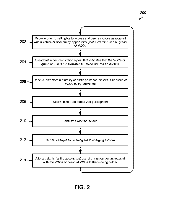
[0068] FIG. 2 illustrates a DTRA method 200 of auctioning a vehicular
occupancy
opportunity element/unit or group of vehicular occupancy opportunity
element/unit
26
CA 02976348 2017-08-10
WO 2016/130755 PCT/US2016/017468
in accordance with an embodiment. The operations of DTRA method 200 may be
performed by a processor or processing core in a DPC 146 component, in a TRCE
component, or a combination thereof In description below, DTRA method 200 may
be performed by a processing core in a DPC 146 component, which may include a
TRCE component.
[0069] In operation 202, the DPC 146 may receive offer for the sale of a
vehicular
occupancy opportunity element/unit (V00) or group of VO0s, and an asking price
for the offered V00 or group of VO0s. The offer for sale may be the offer of a
license to utilize a transportation resource at a current or future time. For
example, a
lessor of a bridge, distance of highway along one lane, cubic area of
airspace, or
distance of waterway, may offer for sale on the transportation resource
commodities
exchange, a license to travel along the bridge, section of highway, airspace,
or
waterway at the time of purchase or on a subsequent date of travel. In some
embodiments, a lessee may sub-lease their interest n the transportation
resource to
other travelers. For example, a commuter with a license to travel in the left
hand
lane of a highway between the hours of 8am-10am may decide to drive in a
slower
lane and offer his/her license up for temporary use by another motorist.
[0070] In operation 204, the DPC 146 may broadcast a communication signal that
includes information suitable for informing a plurality of potential auction
participants that the offered V00 or group of VOOs are available for sale and
of the
asking price for the V00 or group of VO0s. In some embodiments, the broadcast
may be passed to mobile devices 102 of auction participants and may be
displayed
on a screen of the mobile devices. Embodiments including mobile terminals
integrated into automobile dashboards may include receiving the broadcast and
displaying information about the asking price for the license to use the
transportation
resource (e.g., a particular lane of the highway, bridge access, etc) as the
user begins
to access the resource or in advance of accessing the resource.
27
CA 02976348 2017-08-10
WO 2016/130755 PCT/US2016/017468
[0071] In operation 206, the DPC 146 may receive bids from a plurality of
participants (e.g., vehicle operators, investors, etc.) for the V00 or group
of VO0s.
In some embodiments, bids may be made via mobile devices of the auction
participants such as by selecting an on-screen feature on a touch screen
display, or
interacting with an on-screen feature via an input device. Further, some
embodiments may enable users to increase and lower bids from a user interface.
Other embodiments the DPC 146 may increase or lower bids by pre-determined
amounts as bids are entered or withdrawn by users.
[0072] When a vehicle operator enters an area designated for bidding, the
operator
must make a bid, pay a predetermined flat fee, or leave the area. Vehicle
operators
who do not make a bid or pay a flat fee, may be notified that they have a set
amount
of time within which to pay for their use of the resource or penalties may
result.
Penalties for unauthorized resource access may include fines, levies, and or
imposing of moving violations.
[0073] In operation 208, the DPC 146 may accept only the bids received from
authorized participants determined to be eligible to participate in the
auction. For
example, as part of operation 206, the DPC 146 may determine whether the
participants are registered brokers that are authorized to participate in the
resource
auction, and accept only the bids that are received from these authorized
participants. The DPC 146 may further check for the presence of charging
account
information stored in association with broker registration information, to
ensure that
auction participants are able to settle transactions.
[0074] In operation 210, the DPC 146 may identify a winning bidder, such as by
identifying the participant that submitted the last or highest bid for the
current or
future right to access and use resources associated with the V00 or group of
VO0s.
The number of winners may depend upon the nature of the transportation V00 or
group being auctioned. For example, an auction for license to utilize a middle
lane
28
CA 02976348 2017-08-10
WO 2016/130755 PCT/US2016/017468
of a highway may have a rolling set of constantly updating winners as
motorists
enter and exit the section of highway for which the license is sought.
Conversely, an
auction for use of a cubic area of airspace may have only a single winner at
the time
to reduce the likelihood of aircraft collisions.
[0075] In operation 212, the DPC 146 may submit the amount of the winning bid
to a
charging system for settlement of the auction transaction. The charging system
may
be a component of the dynamic transportation resource arbitrage system or may
be a
third-party system such as a bank, a credit union, or other funds management
entity.
In various embodiments, the DPC 146 may attribute a winning bid to a specific
broker, obtain charging system information for the broker account, and submit
the
amount of the winning bid to the identify charging system along with charging
system account information. In some embodiments, the DPC 146 may wait for a
confirmation of successful transaction from the charging system (e.g., funds
are
available in the pertinent account at the time of payment request submission),
while
in other embodiments, the DPC 146 may proceed to operation 214 without waiting
for a charging system confirmation.
[0076] In operation 214, the DPC 146 may allocate the rights for the current
or
future access and use of the resources to the winning bidder. In an
embodiment, this
may accomplished by recording a transaction in a transaction database
identifying
the participant that submitted the winning bid as owning the VOOs and/or
having
exclusive or non-exclusive rights to the access and use of the resources
associated
with the VOOs at a current or future date or time.
[0077] FIG. 3A is an illustration of an embodiment vehicular occupancy
opportunity
element/unit in the form of a vehicular occupancy opportunity element/unit
(V00)
that defines an amount of transportation resource (e.g., 100 miles on Rte-1)
in
relation to a well-defined resource boundary (e.g., sides of the highway,
lanes of the
highway, flight path between two airports, etc.) in the form of a three
dimensional
29
CA 02976348 2017-08-10
WO 2016/130755 PCT/US2016/017468
cube. The cube may be defined based on two fundamental points (X1,Y1,Z1)-
(X2,Y2,Z2). The cube includes three dimensional points (A, B, and C), which
defined at (0,0,0), (1,1,0), and (1,1,1), respectively.
[0078] The V00 may include information identifying various characteristics
and/or
properties of the transportation resource or the resource offering, such as
the specific
access way/roadway, the geographic area(s) in which the resource is offered
for use,
a resource availability time or date, a resource expiration time, a lease
duration,
lease start and stop times or dates, an entryway/exit way status, the service
class of
the resource or offering, etc.
[0079] FIG. 3B is an illustration of table that may be stored in association
with a
V00 to identify these characteristics or properties. The table illustrated in
FIG. 3B
lists the properties/characteristics as parameter-value pairs, and includes a
description field that provides additional information for each parameter. The
parameters may be different for different types of transportation resources.
[0080] FIGs. 4 and 15 are illustrations of various geographical boundaries
associated
with a transportation resource that may be represented by one or more
vehicular
occupancy opportunity elements/units in accordance with the various
embodiments.
Specifically, FIG. 4 illustrates that the geographical boundaries of a
resource may be
represented via single V00 (201) or multiple VOOs that define a sector of road
(202), a whole highway (203), or which represent multiple lanes (204).
[0081] Each V00 cube may represent the most granular geospatial area of
commoditized transportation resource. Each V00 cube may include, identify or
represent an X amount of a transportation resource (e.g., distance of
roadway).
V00 cubes may be aggregated into larger cubes or forms within polygons or
groups
of polygons, and used as a multi-dimensional artillery grid by which those
seeking
resources may identify and select target areas, and as necessary, adjust onto
their
specific optimum target area.
CA 02976348 2017-08-10
WO 2016/130755 PCT/US2016/017468
[0082] FIGs. 5A and 5B illustrate that vehicular occupancy opportunity
elements/units may be combined to define polygons that cover different
geographical areas. FIG. 5C illustrates that vehicular occupancy opportunity
element/unites may combined or arranged so as to form an irregular shape. This
flexibility provides participants with fine grain controls over the resources
they
offer, lease or purchase. Such fine grain controls allow lessee travelers to
purchase
or lease only the resources they require or are likely to use. These fine
grain
controls also allow lessors to more narrowly slice their available resources
so that
they may be leased to more consumers or so that they may be priced more
competitively.
[0083] FIGs. 6A and 6B illustrate that resource cubes (i.e., vehicular
occupancy
opportunity elements/units that include a Z, height, or altitude component)
may be
combined or grouped to define polygons that cover different geographical
areas.
The Z, height, or altitude component of the resource cubes may be defined in
relation to the mean sea level (MSL) or the above ground level (AGL). For
example, altitude component may be defined relative to 100 meters above the
mean
sea level.
[0084] FIG. 6C is an illustration of table that may be stored in association
with a
V00 grouping that defines polygon to identify various properties of the
grouping or
the VOOs that are included in the group. The table illustrated in FIG. 6C
lists the
properties as parameter-value pairs, and includes a description field that
provides
additional information for each parameter. The parameters include a polygon
ID,
number of VOOs included in the grouping, number of VOOs that define an area in
terms of length and width, and number of VOOs that include a value for the Z,
height, or altitude component of the area. In the example illustrated in FIG.
6C, the
V00 grouping has a Polygon ID of "16" and includes 1000 VOOs. All the included
VOOs define an area in terms of length and width, and none of the included
VOOs
31
CA 02976348 2017-08-10
WO 2016/130755 PCT/US2016/017468
include Z, height, or altitude component. That is, all of the included VOOs
are
associated with two-dimensional resource boundaries.
[0085] FIGs. 7A and 7B are illustrations of different vehicular occupancy
opportunity element/unit groupings that share common geodetic reference points
in
accordance with an embodiment. FIG. 7C illustrates that the vehicular
occupancy
opportunity element/unit groupings illustrated in FIGs. 7A and 7B may be
aggregated to increase the availability of the transportation resource. This
aggregation may be accomplished by utilizing a transportation resource
allocation
scheme, and may include overlapping polygons and aggregating vehicular
occupancy opportunity elements/units that have different alignments (e.g.,
lanes of a
highway), distance allocations, or service classes.
[0086] FIGs. 8A through 8C are illustrations of different vehicular occupancy
opportunity element/unit groupings in accordance with an embodiment.
Specifically, FIG. 8A illustrates a vehicular occupancy opportunity
element/unit
grouping in the form of a primary polygon that is defined with a
representative
number of vehicular occupancy opportunity elements/units. FIGs. 8B and 8C
illustrates resource cube groupings corresponding to the primary polygon
illustrated
in FIG. 8A and which form a polygon having a Z, height, or altitude component.
[0087] FIGs. 9A through 9C are illustrations of different vehicular occupancy
opportunity element/unit groupings in accordance with another embodiment. FIG.
9A illustrates a vehicular occupancy opportunity element/unit grouping in the
form
of a primary polygon that is defined with a representative number of vehicular
occupancy opportunity elements/units. FIGs. 9B and 9C illustrates resource
cube
groupings corresponding to the primary polygon illustrated in FIG. 9A and
which
form a polygon having a Z, height, or altitude component. FIGs. 9B and 9C also
illustrate that the resource cube groups do not have to be contiguous in any
32
CA 02976348 2017-08-10
WO 2016/130755 PCT/US2016/017468
direction, and may include a height, length or width variance or gag between
the
vehicular occupancy opportunity elements/units.
[0088] FIG. 10 is an illustration that shows the resource cubes being
associated with
altitude ceilings in airspace in accordance with an embodiment. That is,
different
ceilings of the airspace are designated with different resource cube
combinations or
grouping. The two cube clusters/grouping illustrated in FIG. 10 do not have to
be
coupled, and it is possible that the particular attributes associated with the
different
resource cube groupings share a common polygon but have different attributes
leading to different transportation resource allocations based on the number
of
resource cubes and their relative position in terms of altitude, Z, to the
primary
polygon (e.g., the polygon illustrated in FIG. 9A).
[0089] Alternatively, the resource cubes may be grouped to cover parking
spaces
within a multi-level parking deck having an altitude Z. Each level of the
parking
deck may have a similar number of resource cubes available for lease and
pricing of
vehicular occupancy opportunity elements/units may differ by level of the
parking
garage.
[0090] FIG. 11 illustrates that the resource cubes may be grouped to cover
waterways, tunnels, corridors and other similarly narrow areas. Specifically,
FIG.
11 illustrates a resource group/cluster that includes resource cubes that
include an
altitude and which extend for a distance Y.
[0091] FIG. 12 illustrates that the resource cubes may be grouped to cover
lanes in a
highway, bridges and other similar areas. Such a corridor cluster could cover
the
licensing of highway lanes to travelers, such as the George Washington Bridge
during peak hours of usage. That is, at certain times of the day, some
segments of
the transportation grid come into an over abundance of motorist traffic from
commuters going in and out of New York City. Commuters interested in
travelling
across this zone may want to bid on the exact lane they wish to utilize during
their
33
CA 02976348 2017-08-10
WO 2016/130755 PCT/US2016/017468
commute. Using certain grid allocation techniques, the various embodiments may
allow for bidding on resources for the inbound upper and lower deck of the
bridge
for morning rush hour and then only looking for resources for the outbound
lower
deck for the bridge during the evening rush hour.
[0092] With the resource cubes the need for a common geodetic reference is
needed
to not only facilitate the potential bidder's ability to determine the
viability of an
offered polygon but also enable corridor clusters as well as use of
transportation
resources in multiple tiers of elevation. There are multiple ways of
dissecting the
planet Earth into grids for determining locations, and some are more useful
and
accurate than others. Using the latitude and longitude coordinate system for
defining some of the resource cube dimensions would be a mistake differing
sizes
that the resource cube may have as latitude changes due the earth's curvature.
[0093] One method that would work best however is a system called The
Universal
Transverse Mercator System, better known as "UTM." There are other coordinate
systems like the National Coordinate Systems including Spatial Reference
Systems
(SRS) or the Coordinate Reference System (CRS) that can be used as well.
However
for this example UTM will be used.
[0094] The UTM system divides the earth into 60 separate zones of six degrees
of
longitude each. Also, the earth is separated and labeled A to Z, in respect to
latitude.
The latitude division of the earth gives each section eight degrees of width,
with a
few exceptions. Letters I and 0 are not used to avoid confusion as they are
written
similarly to numbers. Sections A and B take up the southern eighty degrees of
the
globe, and Y and Z take up the northern eighty four degrees, so these sections
cover
the poles, the areas that make the latitude and longitude system nearly
unusable,
creating an amount of distortion that would only be detrimental to defining a
V00
cube. In addition, zone X in the UTM system encompasses twelve degrees of
34
CA 02976348 2017-08-10
WO 2016/130755 PCT/US2016/017468
latitude rather than the standard eight thereby making it's a better
coordinate system
to utilize.
[0095] With this system of creating exact, and useful grids of the planet
earth,
creating a location of an exact point on a two dimensional field becomes quite
simple. If you are aware of which grid you are located in, you can use X and Y
coordinates to determine how far in the X direction and the Y direction a
certain
location is in relation to the grid that you have picked. So going back to the
George
Washington Bridge, you can use UTM to determine the exact location of the
bridge,
or truly, the exact area desired for travel. Using UTM, you can determine the
beginning and end X and Y coordinates, and get as accurate and precise
measurement as desired.
[0096] Using UTM, the earth is already divided into equal sized areas, with a
handful of anomalous spots as you approach the northern and southern poles.
This
means we can create a standard unit of measure of space, and determine its
exact
location by using UTM coordinates. For example, let's say we were to create a
standard unit of a square meter. For the George Washington Bridge, if you had
the
coordinates for the start and end of the bridge, you can divide the determined
area
into square meter blocks, and auction off those in groups or individually,
depending
on who is leasing the resources.
[0097] We can make how we divide resources even more granular however, and
more effective and useful. There are two levels to the George Washington
Bridge,
and a traveler may only be interested in covering the upper level. The UTM
grid
system would work perfectly for helping determine our X and Y coordinates.
However UTM does not have a Z coordinate. Therefore Z coordinate can be
referenced to many points. The most common reference point is relative to sea
level, average mean above sea level (AMSL). Determining the Z coordinates in
relation to sea level gives a universal point of "Zero" for the Z axis. Being
able to
CA 02976348 2017-08-10
WO 2016/130755 PCT/US2016/017468
use the Z axis in determining coverage areas can help determine more exact
prices
of coverage for certain areas, such as levels of airspace and depths of
waterways.
Access to certain heights of the airspace may be worth more to certain people
than
others, and having the ability to choose the height of a unit of coverage
makes that
possible.
[0098] By adding in our third directional coordinates, we can modify our use
of a
basic unit of coverage from being a square meter to a meter cubed leading to
the
V00 cube. Therefore being able to divide the George Washington Bridge, or any
other trafficked area, into a definitive amount of purchasable coverage blocks
can
help unify the way VOOs can be will be used and defined both within any market
But also globally.
[0099] The various embodiments include dynamic transportation resource
arbitrage
(DTRA) methods and components configured to implement the DTRA methods. A
DTRA method may include generating granular vehicular occupancy opportunity
elements/units that each identify an amount of a transportation resource that
is
offered for allocation and use by other travelers with respect to an area or
volume,
and offering the vehicular occupancy opportunity elements/units for purchase,
lease,
or trade on a commodities exchange.
[0100] In an embodiment, generating the granular vehicular occupancy
opportunity
elements/units may include generating vehicular occupancy opportunity
elements/units that use a universal standard to identify, quantify, measure,
and/or
represent the transportation resource. In an embodiment, generating the
granular
vehicular occupancy opportunity elements/units may include generating
vehicular
occupancy opportunity elements/units that identify the transportation resource
in a
standard format, structure, or unit that is readily understood by the trading
community. In an embodiment, generating the granular vehicular occupancy
opportunity elements/units may include generating vehicular occupancy
opportunity
36
CA 02976348 2017-08-10
WO 2016/130755 PCT/US2016/017468
elements/units that include or provide a common reference point against which
other
vehicular occupancy opportunity elements/units and transportation resources
may be
compared. In an embodiment, generating the granular vehicular occupancy
opportunity elements/units may include generating vehicular occupancy
opportunity
elements/units that define a distance of road along a particular lane in
relation to a
geographic area encompassing one cubic meter. In an embodiment, generating the
granular vehicular occupancy opportunity elements/units may include generating
vehicular occupancy opportunity elements/units that may be combined to cover a
precise location or area.
101011 In an embodiment, the DTRA method may include comparing two or more
vehicular occupancy opportunity elements/units that represent different
resource
offerings from different lessors to determine the relative economic value of
the
offered amounts of transportation resource. In an embodiment, the DTRA method
may include combining the vehicular occupancy opportunity elements/units to
cover
an area that encompasses a highway, bridge, navigation path, waterway, air
traffic
corridor, and/or any other similar area. In an embodiment, the vehicular
occupancy
opportunity elements/units may be resource cubes that include an altitude
dimension. In an embodiment, offering the vehicular occupancy opportunity
elements/units for purchase, lease, or trade on a commodities exchange may
include
grouping the vehicular occupancy opportunity elements/units to form a polygon
and
offering the group of vehicular occupancy opportunity elements/units for
purchase,
lease, or trade on the commodities exchange.
[0102] Further embodiments may include a server computing device having a
multi-
core processor that includes two or more processor cores, one or more of which
is
configured with processor-executable instructions to perform operations of the
DTRA methods described above. Further embodiments may include a server
computing device having various means for performing functions of the
operations
of the DTRA methods described above. Further embodiments may include non-
37
CA 02976348 2017-08-10
WO 2016/130755 PCT/US2016/017468
transitory processor-readable storage medium having stored thereon processor-
executable instructions to cause a processor to perform operations of the DTRA
methods described above.
[0103] Various embodiments may be implemented on a variety of mobile wireless
computing devices, an example of which is illustrated in FIG. 13.
Specifically, FIG.
13 is a system block diagram of a mobile transceiver device in the form of a
smal __ tphone/cell phone 1300 suitable for use with any of the embodiments.
The cell
phone 1300 may include a processor 1301 coupled to internal memory 1302, a
display 1303, and to a speaker 1304. Additionally, the cell phone 1300 may
include
an antenna 1305 for sending and receiving electromagnetic radiation that may
be
connected to a wireless data link and/or cellular telephone transceiver 1306
coupled
to the processor 1301. Cell phones 1300 typically also include menu selection
buttons or rocker switches 1307 for receiving user inputs.
[0104] A typical cell phone 1300 also includes a sound encoding/decoding
(CODEC) circuit 1308 which digitizes sound received from a microphone into
data
packets suitable for wireless transmission and decodes received sound data
packets
to generate analog signals that are provided to the speaker 1304 to generate
sound.
Also, one or more of the processor 1301, wireless transceiver 1306 and CODEC
1308 may include a digital signal processor (DSP) circuit (not shown
separately).
The cell phone 1300 may further include a ZigBee transceiver (i.e., an IEEE
802.15.4 transceiver) for low-power short-range communications between
wireless
devices, or other similar communication circuitry (e.g., circuitry
implementing the
Bluetooth or WiFi protocols, etc.).
[0105] The embodiments described above, including the DTRA and transportation
resource arbitrage functions, may be implemented on any of a variety of
commercially available server devices, such as the server 1400 illustrated in
FIG.
14. Such a server 1400 typically includes a processor 1401 coupled to volatile
38
CA 02976348 2017-08-10
WO 2016/130755 PCT/US2016/017468
memory 1402 and a large capacity nonvolatile memory, such as a disk drive
1403.
The server 1400 may also include a floppy disc drive, compact disc (CD) or DVD
disc drive 1404 coupled to the processor 1401. The server 1400 may also
include
network access ports 1406 coupled to the processor 1401 for establishing data
connections with a network 1407, such as a local area network coupled to other
communication system computers and servers.
[0106] The processors 1301, 1401, may be any programmable microprocessor,
microcomputer or multiple processor chip or chips that can be configured by
software instructions (applications) to perform a variety of functions,
including the
functions of the various embodiments described below. In some wireless
devices,
multiple processors 1401 may be provided, such as one processor dedicated to
wireless communication functions and one processor dedicated to running other
applications. Typically, software applications may be stored in the internal
memory
1302, 1402, before they are accessed and loaded into the processor 1301, 1401.
The
processor 1301, 1401 may include internal memory sufficient to store the
application software instructions. In some servers, the processor 1401 may
include
internal memory sufficient to store the application software instructions. In
some
receiver devices, the secure memory may be in a separate memory chip coupled
to
the processor 1301. The internal memory 1302, 1402 may be a volatile or
nonvolatile memory, such as flash memory, or a mixture of both. For the
purposes
of this description, a general reference to memory refers to all memory
accessible by
the processor 1301, 1401, including internal memory 1302, 1402, removable
memory plugged into the device, and memory within the processor 1301, 1401
itself.
[0107] FIG. 15 illustrates an example corridor configuration vehicular
occupancy
opportunity element/unit grouping in accordance with various embodiments. As
discussed above, each vehicular occupancy opportunity element/unit (V00) may
define an amount of transportation resource (e.g., 100 miles on Rte-1) in
relation to
39
CA 02976348 2017-08-10
WO 2016/130755 PCT/US2016/017468
a well-defined resource boundary (e.g., lanes of the highway, area between
Richmond and Washington DC, etc.). In addition, each V00 may include
information identifying various characteristics and/or properties of the
transportation
resource or the resource offering, such as the specific access way/roadway,
the
geographic area(s) in which the resource is offered for use, a resource
availability
time or date, a resource expiration time, a lease duration, lease start and
stop times
or dates, an entryway/exit way status, the service class of the resource or
offering,
etc.
101081 In the example illustrated in FIG. 15, there are three lanes (i.e., Li,
L2, and
L3) of transportation resources available. The first lane Li includes a first
grouping
of vehicular occupancy opportunity elements/units (i.e., VOOs 11, 12, 13, 14,
15,
and 1X), and second first lane L2 includes a second grouping of vehicular
occupancy opportunity elements/units (i.e., VOOs 21, 22, 23, 24, 25, and 2X).
The
third lane L3 may be an open or "free" lane that is not organized into
vehicular
occupancy opportunity elements/units. V00 11 may define a first segment of
road
within the first lane Li, V00 12 may define a second segment of road within
the
first lane Li, etc. Similarly, V00 21 may define a first segment of road
within the
second lane L2, V00 22 may define a second segment of road within the second
lane L2, etc. Each of these segments may be associated with a speed or
congestion
value. For example, the V00 11 may include a speed value that indicates that a
vehicle may travel over its associated segment at speeds up to 70 miles per
hour,
whereas the V00 21 may include a speed value that indicates that the vehicle
may
travel over its associated segment at speeds up to 50 miles per hour. As such,
the
value of V00 11 may be greater than the value of V00 21 to a purchaser or
lessee.
101091 A DPC 146 component may be configured to dynamically manage the
availability, allocation, access, and use of the available transportation
resources
(e.g., the three lanes Li, L2 and L3). For example, the DPC 146 component may
monitor the location and position of a vehicle as it travels down the roadway
in the
CA 02976348 2017-08-10
WO 2016/130755 PCT/US2016/017468
third lane L3. When the vehicle begins to change lanes and/or otherwise
requests to
enter the second lane L2, the DPC 146 component may determine whether VOOs 21
through 2X are available (e.g., based on number of units outstanding, the
amount of
traffic in the second lane L2, etc.), and offer the available V00 units for
allocation
to the vehicle (e.g., by communicating with a computing device in the vehicle,
etc.).
The DPC 146 may receive a bid from the vehicle for the access or use of the
second
lane (VOOs 21 through 2X), determine that the vehicle is a winning bidder,
send a
message to a charging system to receive payment for the relevant VOOs,
allocate the
relevant VOOs to the vehicle (e.g., by updating a transaction database, etc.),
and
authorize the vehicle to enter and use the segments associated with the
allocated
VOOs. The DPC 146 component may continue monitoring the location and position
of the vehicle as it travels down the second lane L2, and any or all of the
above
operations repeated when the vehicle moves from the second lane L2 into the
first
lane Li.
101101 FIG. 16 illustrates components and operations in a system 1600
configured to
perform dynamic transportation resources arbitrage (DTRA) operations for
allocating the rights for the access and use of a transportation resource
associated
with a vehicular occupancy opportunity element/unit or group of vehicular
occupancy opportunity elements/units in accordance with an embodiment. In the
example illustrated in FIG. 16, the system 1600 includes DPC 146 component
that is
configured to communicate with a first DRC 144a component in a first
network/system 1602, a second DRC 144b component in a second network/system
1604, a third DRC 144c component in a third network/system 1606, and a fourth
DRC 144d component in a fourth network/system 1608. Each of the DRCs 144a,
144b, 144c, and 144d may be responsible for managing different type or
category of
vehicular occupancy opportunity elements/units. For example, the first DRC
144a
may be configured to request, submit bids on, receive, allocate, and monitor
the use
of vehicular occupancy opportunity elements/units for commercial aircraft,
41
CA 02976348 2017-08-10
WO 2016/130755 PCT/US2016/017468
chartered aircraft, and drone navigation. The second DRC 144b may be
configured
to request, submit bids on, receive, allocate, and monitor the use of
vehicular
occupancy opportunity elements/units for highway traffic, bridges and tunnels,
and
secondary roads. The third DRC 144c may be configured to request, submit bids
on,
receive, allocate, and monitor the use of vehicular occupancy opportunity
elements/units for inter-coastal shipping lanes and sea shipping lanes. The
fourth
DRC 144d may be configured to request, submit bids on, receive, allocate, and
monitor the use of vehicular occupancy opportunity elements/units for garage
parking and street parking.
[OM] FIG. 17 illustrates components and operations in a system 1700 configured
to
perform dynamic transportation resources arbitrage (DTRA) operations in
accordance with another embodiment. In the example illustrated in FIG. 17, the
system 1700 includes a transportation resource commodity exchange (TRCE) 1702
component, an over-the-counter corridor trading (OCT) 1704 component, a DPC
146 component, a first DRC 144a component, a second DRC 144b component, a
third DRC 144c component, and a fourth DRC 144d component. In some
embodiments, the TRCE 1702 component and/or the OCT 1704 component may be
included in, or implemented as part of, the DPC 146 component.
101121 Each of the DRCs 144 may be responsible for controlling or managing
different type or category of transportation resources. For example, the first
DRC
144a may be responsible for managing aircraft resources, the second DRC 144b
may
be responsible for managing roadway resources, the third DRC 144c may be
responsible for managing shipping lane resources, and the fourth DRC 144d may
be
responsible for managing vehicular storage resources (parking, etc.).
[0113] The OCT 1704 component may be configured to group resource cubes to
generate a corridor cluster that covers lanes in a highway, bridges and other
similar
areas, and send information identifying the grouped vehicular occupancy
42
CA 02976348 2017-08-10
WO 2016/130755 PCT/US2016/017468
opportunity elements/units or corridor cluster to the DPC 146 component and/or
the
TRCE 1702 component. For example, the OCT 1704 component may generate a
corridor cluster that covers the licensing of a lane over the George
Washington
Bridge during peak hours of usage. As a further example, the OCT 1704
component
may group the vehicular occupancy opportunity elements/units so as to allow
the
DPC 146 component to offer transportation resources that cover the inbound
upper
and lower deck of the George Washington Bridge for morning rush hour, and the
outbound lower deck during the evening rush hour.
[0114] The TRCE 1702 component may be configured to perform various operations
to allow participants to buy, sell, and exchange vehicular occupancy
opportunity
elements/units or groups of vehicular occupancy opportunity elements/units.
For
example, the TRCE 1702 may component may be configured to receive information
identifying corridor cluster from the OCT 1704 component, pool or package the
vehicular occupancy opportunity elements/units associated with the corridor
cluster
into a resource package, and offer the resource package for auction via the
DPC 146
component. For example, the TRCE component 1702 may broadcast information
that identifies the corridor cluster, and receive resource bids for the right
to access
and use the corridor cluster from the DRC 144a-d components via the DPC 146
component. The TRCE component 1702 may identify the DRC 144 that submitted
highest bid as the winner of the resource, and instruct the DPC 146 component
to
allocate the corridor cluster to the winning DRC 144.
[0115] FIG. 18 illustrates a dynamic transportation resource arbitrage (DTRA)
method 1800 of generating and using vehicular occupancy opportunity
elements/units in accordance with an embodiment. DTRA method 1800 may be
performed by one or more processors of one or more server computing devices
that
implement all or portions of a DPC component. In block 1802, a processor of
the
DPC component may receive information identifying transportation resources
(e.g.,
rights to use a roadway segment, etc.) that are offered for purchase, lease or
trade.
43
CA 02976348 2017-08-10
WO 2016/130755 PCT/US2016/017468
In block 1804, the processor may determine the encumbrances, characteristics
and/or properties of the transportation resources that are offered for
purchase, lease
or trade.
[0116] In block 1806, the processor may identify, define, quantify, pool,
partition,
organize, and/or package the offered transportation resources based on their
characteristics and/or properties into well-defined, granular, discrete,
standardized,
combinable and/or fungible vehicular occupancy opportunity elements/units that
are
suitable for comparison and/or mutual substitution. For example, in block
1806, the
processor may generating granular vehicular occupancy opportunity
elements/units
that each identify an amount of a transportation resource that is offered for
allocation and use by travelers with respect to an area. In block 1808, the
processor
may classify or grade each vehicular occupancy opportunity element/unit based
on
the encumbrances, properties or characteristics of its offered resources. In
some
embodiments, the processor may combine the granular vehicular occupancy
opportunity elements/units to cover a specific corridor (e.g., an area that
encompasses a lane in a highway, a bridge, an air traffic corridor, etc.) in
block
1808. In block 1810, the processor may broadcast or transmit a communication
signal that identifies the generated vehicular occupancy opportunity
elements/units,
their underlying resources, their classifications/grades and information
indicating
that the vehicular occupancy opportunity elements/units are available for
purchase,
lease or trade. In block 1812, the processor may receive and accept requests
(e.g.,
purchase requests, bids, etc.) for the purchase, lease or trade of one or more
of the
generated vehicular occupancy opportunity elements/units from many DRC 144
components. In block 1814, the processor may identify a winning bid and/or
winning DRC 144 component, and record a transaction in a transaction database
identifying one or more of the vehicular occupancy opportunity elements/units
as
being allocated to the winning DRC 144 component.
44
CA 02976348 2017-08-10
WO 2016/130755 PCT/US2016/017468
[0117] As used in this application, the terms "transportation vehicle" and
"vehicle" may be interchangeable and/or used to denote any passenger vehicle
capable of accessing the various modalities of a modern transportation grid.
Non-
limiting examples of such vehicles may include automobiles, motorcycles,
boats,
trains, submersibles, dirigible airships, or planes. Transportation vehicles
may
further include manual vehicles such as bicycles. While the embodiments
described
herein are directed towards automobiles and motorcycles, the systems and
methods
may be generally useful to allocating resources of any component of a
transportation
grid irrespective of the modality of transit.
101181 As used in this application, the terms "mobile device," "console unit",
"cellular telephone," and "cell phone" may be interchangeable and used to
refer to
any one or all of integrated or add-on transportation vehicle component
devices,
cellular telephones, smal tphones, personal data assistants (PDA's), laptop
computers, tablet computers, ultrabooks, palm-top computers, wireless
electronic
mail receivers, multimedia Internet enabled cellular telephones, wireless
gaming
controllers, and similar personal electronic devices which include a
programmable
processor, a memory and circuitry for sending and/or receiving wireless
communication signals. While some embodiments are particularly useful in
mobile
devices, such as cellular telephones, these embodiments are generally useful
in any
computing device that may be used to wirelessly communicate information.
101191 As used in this application, the term "charging system" refers to one
or
more components (e.g., server computing devices, etc.) that are closely
associated
with a bank, credit union, or other financial institution where funds may be
managed
or stored and payments processed. A charging system component may be
configured receive requests for payment, attribute the request to a user
account,
deduct funds from the user account, submit payment information to a financial
institution of the payment requester (e.g., settling transactions), and
perform other
similar operations.
CA 02976348 2017-08-10
WO 2016/130755 PCT/US2016/017468
[0120] As used in this application, the terms "wireless network", "network",
"cellular system", "cell tower" and "radio access point" may interchangeable
and
used to refer to any one of various wireless mobile systems or components for
wirelessly communicating information. In an embodiment, a wireless network may
be a radio access point (e.g., a cell tower), which provides the radio link to
the
mobile device so that the mobile device may communicate with components in the
core network.
101211 As used in this application, the terms "component," "module," and the
like
are intended to include a computer-related entity, such as, but not limited
to,
hardware, firmware, a combination of hardware and software, software, or
software
in execution, which are configured to perform particular operations or
functions.
For example, a component may be, but is not limited to, a process running on a
processor, a processor, an object, an executable, a thread of execution, a
program, a
computer, a server, network hardware, etc. By way of illustration, both an
application running on a computing device and the computing device may be
referred to as a component. One or more components may reside within a process
and/or thread of execution and a component may be localized on one processor
or
core and/or distributed between two or more processors or cores. In addition,
these
components may execute from various non-transitory computer readable media
having various instructions and/or data structures stored thereon.
[0122] A number of different cellular and mobile communication services and
standards are available or contemplated in the future, all of which may
implement
and benefit from the various embodiments. Such services and standards include,
e.g., third generation partnership project (3GPP), long term evolution (LTE)
systems, third generation wireless mobile communication technology (3G),
fourth
generation wireless mobile communication technology (4G), global system for
mobile communications (GSM), universal mobile telecommunications system
(UMTS), 3GSM, general packet radio service (GPRS), code division multiple
access
46
CA 02976348 2017-08-10
WO 2016/130755 PCT/US2016/017468
(CDMA) systems (e.g., cdmaOne, CDMA2000TM), enhanced data rates for GSM
evolution (EDGE), advanced mobile phone system (AMPS), digital AMPS (IS-
136/TDMA), evolution-data optimized (EV-D0), digital enhanced cordless
telecommunications (DECT), Worldwide Interoperability for Microwave Access
(WiMAX), wireless local area network (WLAN), public switched telephone
network (PSTN), Wi-Fi Protected Access I & II (WPA, WPA2), Bluetooth ,
integrated digital enhanced network (iden), and land mobile radio (LMR). Each
of
these technologies involves, for example, the transmission and reception of
voice,
data, signaling and/or content messages. It should be understood that any
references
to terminology and/or technical details related to an individual
telecommunication
standard or technology are for illustrative purposes only, and are not
intended to
limit the scope of the claims to a particular communication system or
technology
unless specifically recited in the claim language.
[0123] A number of different methods, technologies, solutions, and/or
techniques
(herein collectively "solutions") are currently available for determining the
location
of mobile device, any or all of which may be implemented by, included in,
and/or
used by the various embodiments. Such solutions include, e.g., global
positioning
system (GPS) based solutions, assisted GPS (A-GPS) solutions, and cell-based
positioning solutions such as cell of origin (C00), time of arrival (TOA),
observed
time difference of arrival (OTDOA), advanced forward link trilateration
(AFLT),
and angle of arrival (AOA). In various embodiments, such solutions may
implemented in conjunction with one or more wireless communication
technologies
and/or networks, including wireless wide area networks (WWANs), wireless local
area networks (WLANs), wireless personal area networks (WPANs), and other
similar networks or technologies. By way of example, a WWAN may be a Code
Division Multiple Access (CDMA) network, a Frequency Division Multiple Access
(FDMA) network, an OFDMA network, a 3GPP LTE network, a WiMAX (IEEE
802.16) network, and so on. The WPAN may be a Bluetooth network, an IEEE
47
CA 02976348 2017-08-10
WO 2016/130755 PCT/US2016/017468
802.15x network, and so on. A WLAN may be an IEEE 802.11x network, and so
on. A CDMA network may implement one or more radio access technologies
(RATs) such as CDMA2000, Wideband-CDMA (W-CDMA), and so on.
[0124] The foregoing method descriptions and the process flow diagrams are
provided merely as illustrative examples and are not intended to require or
imply
that the steps of the various embodiments must be performed in the order
presented.
As will be appreciated by one of skill in the art the order of steps in the
foregoing
embodiments may be performed in any order. Words such as "thereafter," "then,"
"next," etc. are not intended to limit the order of the steps; these words are
simply
used to guide the reader through the description of the methods. Further, any
reference to claim elements in the singular, for example, using the articles
"a," "an"
or "the" is not to be construed as limiting the element to the singular.
[0125] The various illustrative logical blocks, modules, circuits, and
algorithm steps
described in connection with the embodiments disclosed herein may be
implemented
as electronic hardware, computer software, or combinations of both. To clearly
illustrate this interchangeability of hardware and software, various
illustrative
components, blocks, modules, circuits, and steps have been described above
generally in terms of their functionality. Whether such functionality is
implemented
as hardware or software depends upon the particular application and design
constraints imposed on the overall system. Skilled artisans may implement the
described functionality in varying ways for each particular application, But
such
implementation decisions should not be interpreted as causing a departure from
the
scope of the present invention.
[0126] The hardware used to implement the various illustrative logics, logical
blocks, modules, and circuits described in connection with the embodiments
disclosed herein may be implemented or performed with a general purpose
processor, a digital signal processor (DSC), an application specific
integrated circuit
48
CA 02976348 2017-08-10
WO 2016/130755 PCT/US2016/017468
(ASIC), a field programmable gate array (FPGA) or other programmable logic
device, discrete gate or transistor logic, discrete hardware components, or
any
combination thereof designed to perform the functions described herein. A
general-
purpose processor may be a microprocessor, But, in the alternative, the
processor
may be any conventional processor, controller, microcontroller, or state
machine. A
processor may also be implemented as a combination of computing devices, e.g.,
a
combination of a DPC and a microprocessor, a plurality of microprocessors, one
or
more microprocessors in conjunction with a DPC core, or any other such
configuration. Alternatively, some steps or methods may be performed by
circuitry
that is specific to a given function.
[0127] In one or more exemplary aspects, the functions described may be
implemented in hardware, software, firmware, or any combination thereof If
implemented in software, the functions may be stored as one or more
instructions or
code on a non-transitory computer-readable medium or non-transitory processor-
readable medium. The steps of a method or algorithm disclosed herein may be
embodied in a processor-executable software module which may reside on a non-
transitory computer-readable or processor-readable storage medium. Non-
transitory
computer-readable or processor-readable storage media may be any storage media
that may be accessed by a computer or a processor. By way of example But not
limitation, such non-transitory computer-readable or processor-readable media
may
include RAM, ROM, EEPROM, FLASH memory, CD-ROM or other optical disk
storage, magnetic disk storage or other magnetic storage devices, or any other
medium that may be used to store desired program code in the form of
instructions
or data structures and that may be accessed by a computer. Disk and disc, as
used
herein, includes compact disc (CD), laser disc, optical disc, digital
versatile disc
(DVD), floppy disk, and blu-ray disc where disks usually reproduce data
magnetically, while discs reproduce data optically with lasers. Combinations
of the
above are also included within the scope of non-transitory computer-readable
and
49
CA 02976348 2017-08-10
WO 2016/130755 PCT/US2016/017468
processor-readable media. Additionally, the operations of a method or
algorithm
may reside as one or any combination or set of codes and/or instructions on a
non-
transitory processor-readable medium and/or computer-readable medium, which
may be incorporated into a computer program product.
[0128] The preceding description of the disclosed embodiments is provided to
enable
any person skilled in the art to make or use the present invention. Various
modifications to these embodiments will be readily apparent to those skilled
in the
art, and the generic principles defined herein may be applied to other
embodiments
without departing from the spirit or scope of the invention. Thus, the present
invention is not intended to be limited to the embodiments shown herein But is
to be
accorded the widest scope consistent with the following claims and the
principles
and novel features disclosed herein.