Note: Descriptions are shown in the official language in which they were submitted.
CA 02978500 2017-09-01
METHOD FOR AUTOMATICALLY EXTRACTING TECTONIC FRAMEWORK OF
POTENTIAL FIELD DATA
Field of the Invention
The present invention relates to a method for automatically extracting
structural framework from
gravity potential field data and magnetic potential field data, which is a
technique for detecting
geological structure based on gravity anomaly data and magnetic anomaly data.
More specifically,
the present invention is in the fields of wavelet analysis, image processing,
geophysics, geology
and mineral exploration. The method of the present invention can be directly
applied to the fields
of mineral exploration and related geological survey.
Background of the Invention
With the development of airborne geophysical exploration technology, gravity
and magnetic
(hereunder called as "gravity-magnetic") measurement methods have the
advantages of economy,
rapidness and covering landscape areas which are difficult to reach, and play
a more and more
important role in exploration and evaluation of metal ore deposits.
Especially, with the
development of high-precision aeromagnetic survey technique, methods for
detecting geological
structures controlling for-nation of the ore deposits based on the magnetic
anomaly data are very
important in all exploration stages from region selection to target selection.
At present, in the field
of mineral exploration, gravity-magnetic exploration are usually applied to
direct detection of
strong-magnetism or high-density mineralized bodies, and to interpretation and
inversion of strong-
anomaly geological structures. Most nonferrous metal and rare metal ore
deposits cannot directly
form obvious gravity-magnetic anomalies. However, geological structures
controlling the
formation of ore deposits can produce anomaly differences. Therefore,
detection of geological
structures controlling the formation of ore deposits based on gravity
potential field data and
magnetic potential field data is important in localization of the targets of
metal ore deposits.
1
CA 02978500 2017-09-01
Nowadays, methods for automatically identifying and extracting structural
information from
gravity-magnetic potential fields mainly include analytic signal method, Euler
deconvolution
method, multiscale edge detection method of potential field, etc. These
methods have problems of
being not sensitive to directional information, and cannot obtain complete and
accurate anomaly
boundary locations. A Chinese patent application No. 200810006676.6, titled
"Multidirectional
and Multiscale Edge Detection Method of Potential Field" of the applicant of
the present invention
discloses a multidirectional and multiscale edge detection method of potential
field, which
enhances directional information through directional wavelet transform,
obtains information about
anomaly source boundaries in different directions, achieves automatic
extraction of structural
framework, overcomes the problem of being not sensitive to directional
information in analytic
signal method, Euler deconvolution method and multiscale edge detection method
of potential
field, and is a technical solution for rapid inversion of three-dimensional
structures of shallow
crusts based on potential field data. However, this method still has the
following problems: (1) the
edges obtained through calculation are not single-pixel point width, actual
geographical ranges
corresponding to the edges and the intersections of the edges in different
directions are large, which
causes the accuracy of analysis result not high; (2) a three-dimensional
structural map of shallow
crusts is obtained by artificial vectorization to different scales of edges
and taking connection lines
of edge centers as anomaly boundaries, which causes a low working efficiency;
(3) the three-
dimensional structural map of shallow crusts shows only information about
structures at different
depths, cannot reflect lithological changes of structural belts and of the two
sides, and cannot
indicate defonuation and activity intensity of structures; and (4) scales are
not clearly defined, i.e.,
no specific geophysical attribute is given to the feature of scale. Therefore,
there is a need on a
method capable of precisely extracting a structural framework from potential
field based on the
acquired potential field data.
Furthermore, compared to gravity anomalies, magnetic anomalies are more
complex due to the
influence of magnetization direction. Usually, the Total magnetic intensity
(TMI) recorded by a
2
CA 02978500 2017-09-01
modern magnetometer is a component in a direction in parallel with the
direction of the main
magnetic field of the Earth. By performing international geomagnetic reference
field correction to
TMI, TMI anomalies can be obtained. Due to the influence of oblique
magnetization, TMI
anomalies have the problems of lateral deviation, pattern deformation, as well
as positive and
negative value change, for example. Usually, the influence of the above
factors is eliminated by
reduction-to-pole processing to TMI anomaly data. With the reduction-to-pole,
the observed TMI
anomalies are transformed into vertical magnetic anomalies under the vertical
magnetization
situation, i.e., the observed TMI anomalies are transformed into the anomalies
which can be
measured at the north magnetic pole, such that magnetic anomalies are migrated
to the locations
directly above their sources to facilitate geological interpretation of
magnetic anomalies.
However, under the influence of the small magnetic inclination and noise, it
is difficult to obtain
reliable magnetic anomaly data with vertical magnetization by performing
reduction to pole to TMI
anomalies data in low-latitude (which usually refers to a magnetic inclination
in range of 200)
areas. Current methods for automatically identifying and extracting magnetic
structure information
from the TMI anomaly data after reduction to pole, such as analytic signal
method, Euler
deconvolution method, phase symmetry, multiscale edge detection method of
potential field data
and multidirectional and multiscale edge detection method of potential fiend
data are not adapted
to automatic identification of magnetic structure information in low-latitude
areas.
Therefore, there is a need to provide a method capable of precisely extracting
a geological structural
framework based on data of magnetic anomalies in low-latitude areas.
Summary of the Invention
The purpose of the present invention is to provide a method for automatically
extracting structural
framework from gravity-magnetic potential field data, to rapidly obtain
information about
geological structures controlling the formation of the ore deposits so as to
achieve localization of
3
CA 02978500 2017-09-01
the targets of metal ore deposits. The present invention further provides a
method for automatically
extracting magnetic structural framework in low-latitude areas, which not only
obtains lineaments,
but also obtain ring structures. The present invention defines the structure
thus obtained as a
structural framework.
In order to achieve this purpose, the present invention provides a method
comprising extracting
gravity structural framework or magnetic structural framework by applying a
multidirectional and
multiscale edge detection to the measured gravity potential field data and
magnetic potential field
data, thinning the obtained structural framework of each scale into a single-
pixel width with a
morphological skeleton algorithm; highlighting information about structures at
different depths by
rendering the structural frameworks at different scales with different
gradually changing colors and
stacking on upon the other, to generate a composite structural framework map;
and highlighting
the intensity information of density change and magnetism change by rendering
the structural
intensity values extracted from gradient modulus corresponding to each edge
point on structural
frameworks at different scales with different gradually changing colors and
stack one upon the
other, to generate a composite structural intensity framework map. Thereby,
the solution of the
invention may obtain information about gravity-magnetic anomalies at different
depths in a study
area, information about distribution of structural frameworks representing
geological structures at
different depths and information about intensity of density change and
magnetism change of
structural frameworks at different depths, to identify and qualitatively
interpret geological
structures controlling the formation of ore deposits, and may determine the
potential ore deposit
types and attributes of structures controlling the formation of ore deposits
according to priori
knowledge about the study area, to screen the different types of structural
frameworks, to localize
the targets of metal ore deposits.
The present invention provides a method for automatically extracting a
structural framework of
potential field, comprising the following steps:
4
CA 02978500 2017-09-01
1) Preprocessing is performed to the gravity data or magnetic data measured
from an study area.
The preprocessing comprises reducing the magnetic data to the pole to obtain
reduction-to-pole
magnetic anomalies or pseudo-gravity transforming the magnetic data to pseudo-
gravity
anomalies; or preprocessing the gravity data to obtain Bouguer gravity
anomalies.
2) Applying multidirectional edge detection of the potential field data
respectively to the
preprocessed gravity potential field data or magnetic potential field data at
a plurality of scales,
comprises upward continuing the potential field data for a plurality of
predetermined heights to
obtain gravity potential field data or magnetic potential field data at the
plurality of scales, and
applying multidirectional edge detection respectively to the obtained
potential field data at each
scale to obtain the potential field edges of the scale.
By selecting different directions a to apply edge detection for each scale
upward-continued for the
plurality of the predetermined heights, information about edges in different
directions may be
highlighted. In order to achieve complete coverage, the direction value a is
taken as kit/(2''),
wherein k=0, 1, 2...(211-1) and n is an integer greater than or equal to 2. In
each direction, the points
with local maximum of modulus of two-dimensional directional wavelet transform
of the
preprocessed gravity data or magnetic data are connected in a direction
perpendicular to the
gradient to form curves and create edges. Edges calculated in a plurality of
different directions at
the same scale are obtained, a union of all the obtained edges is taken as the
edges at the scale, and
thereby multidirectional edge detection of the potential field data at all
scales can be achieved.
3) Thinning the calculated edges at the scales into single-pixel width
respectively by using a
morphological skeleton algorithm to obtain structural frameworks at the
scales.
4) Stacking the calculated structural frameworks of the scales one upon the
other to generate a
composite structural framework map.
5
CA 02978500 2017-09-01
The obtained structural frameworks at all scales are stacked to generate a
composite structural
framework map reflecting information at different depths. The lateral
deviation of edges at different
scales on the map reflects information about attitude of structural
frameworks.
By corresponding the edges extracted from the potential fields upward-
continued for different
heights to structures at different depths, with the depth being half of the
height after upward
continuation (see A Case for Upward Continuation as a Standard Separation
Filter for Potential-
Field Maps, Jacobsen, B.H., Geophysics, v.52 no.8, 1987), the structural
framework maps
representing different depths may be obtained.
5) Taking the gradient modulus at each edge point on the calculated edges as
an intensity value of
this edge point on the structural framework. The magnitude of the intensity
values of the edge
points on the structural framework to which intensity values are assigned
reflects the magnitude of
lithological changes of a structural belt and two sides, and reflects
intensity of deformation and
activity of the structure. By creating the intensity framework maps of
different scales to reflect
information at different depths, and by stacking the intensity framework maps
of different scales
to generate the composite structural intensity framework map, the regional
geological tectonic
framework is revealed.
Further, total horizontal derivatives of tilt derivatives (TDR) and analytic
signals of TMI anomaly
data are not influenced by magnetic inclination, calculation results are not
related to the magnitude
of magnetic inclination, and calculation of total derivatives of TDR and
analytic signals may be
directly performed to TM1 anomaly data without reduction-to-pole processing.
However,
calculation results of analytic signal method may increase the range of
magnetic anomalies, loss
geological structure attitude information and structure zoning information and
be not sensitive to
identification of geological structures. However, current results of total
horizontal derivatives of
tilt derivatives are expressed in form of grid images or contour maps, and
useful information for
geological interpretation and mineral exploration such as structure depth,
primary and secondary
6
CA 02978500 2017-09-01
relation, cutting relation and magnetic intensity cannot be represented. The
traditional edge
detection method based on horizontal gradient without considering the
directional information of
data may not obtain the complete and accurate boundary locations of source
bodies of magnetic
anomalies. By applying multidirectional edge detection based on total
horizontal derivatives of tilt
derivatives at a plurality of scales to the preprocessed TMI anomaly data, the
present invention can
effectively identify and establish magnetic structural frameworks in low-
latitude areas. Therefore,
the method for automatically extracting the structural framework according to
the present invention
is particularly applicable to automatic extraction of structural frameworks of
magnetic measure
data in low-latitude area.
According to one aspect of the present invention, the invention provides a
method for automatically
extracting a structural framework from a potential field data, comprising the
following steps:
preprocessing the potential field data from a study area;
upward continuing the preprocessed potential field data for a plurality of
predetermined heights to
obtain a plurality of potential field data at the corresponding scales;
applying multidirectional edge detection respectively to the plurality of
potential field data at the
scales to obtain a plurality of potential field edges at the corresponding
scales; and
thinning the obtained potential field edges at the scales respectively into a
single-pixel width with
a morphological skeleton algorithm to obtain a plurality of structural
framework maps at the
corresponding scales.
Preferably, the method further comprises stacking one upon the other the
obtained plurality of
structural framework maps at the corresponding scales to generate a composite
structural
framework map.
Preferably, the method further comprises using the gradient modulus of each
edge point on the
structural framework map at each scale as an intensity value of the edge point
on the structural
7
CA 02978500 2017-09-01
framework map at the scale to obtain the plurality of structural intensity
framework maps at the
corresponding scales.
Preferably, the method further comprises stacking the plurality of structural
intensity framework
maps at the corresponding scales one upon the other to generate a composite
structural intensity
framework map.
Preferably, the potential field data are gravity potential field data or
magnetic potential field data,
and the step of preprocessing further comprises: preprocessing the gravity
data to obtain Bouguer
gravity anomalies; or reducing the magnetic data to the pole to obtain
reduction-to-pole magnetic
anomalies or applying pseudo-gravity transformation to the magnetic data to
obtain pseudo-gravity
anomalies.
Preferably, the step of applying multidirectional edge detection to the
potential field data at each
scale comprises the following steps:
supposing that the scale s=z/zo, z>zo, zo is the measurement height and z is
height increasing
upward, defining a gravity anomaly or magnetic anomaly at a location (x, y) at
height of zero as
fo(x, y),
defining a smoothing function at the scale s as:
0,(x.y) = 0 + = yr_ (x, y)
s s 40
1 ,
Iszp(x- Y) ¨221-K
X, } ,SZ0)
wherein , k(x, y, z) is the Green's function,
defining a wavelet function in direction a as:
= cos a¨ + sin a ¨a e (x, y) = Da8 (x, y)
Ct
8
CA 02978500 2017-09-01
=
wherein D represents a first-order derivative;
for the scale s and the location (x, y), defining wavelet transform of the
gravity anomaly or magnetic
anomalyfb(x, y) in direction a as:
Wa [4] (x. y, s) = * 1(x. y)
= fo* (sDa 8,)
= sDa [A* Osi
sDa f * szol
wherein * represents convolution operation,
it is known that according to a potential field
upward
continuation formula, and
fz(x, y) is a gravity anomaly or a magnetic anomaly via upward continuation
offo(x, y) from height
zero to height z=szo and is obtained by upward continuing the gravity anomaly
or magnetic
anomalyfz0(x, y) measured at measurement height zo for height z-zo,
hence,
Wa [t) ](x. y õs) = sD" fz(x, y)
= (z I z0)IY2 (x, y) =
further, for the scale s and the location (x, y), defining a wavelet transform
of the gravity anomaly
or magnetic anomalyfo(x, y) in direction a+12 as:
z z
a ¨ l
W 2 {f01(x, s) = (Z I Zo)Da 2 f (x, y)
9
CA 02978500 2017-09-01
so, the two-dimensional wavelet transform offi(x, y) is written as in
gradient:
\ .\
(Walfol(x, Y, s) ( D'' 11,(x, y)
W [fol(x, Y ,s,a) = a t -_7 = - (Z I Zõ) II
If I-
047 2U-01(X, Y,S) j n 2 ft (X, Y))
W [fo i(X, Y,S,a)= (z I zo)V.f1(x, Y 'a)
wherein V denotes the two-dimensional gradient, and
for the location (x, y), the scale s and the direction a, a two-dimensional
direction wavelet transform
W [ fa 1( x:, y , s , a) Vf (x, y,a)
fo(x, y) is in direct proportion to gradient ' z
of fz(x, y), and
W Lfolix, Y .")
the two-dimensional direction wavelet transform
offo(x, y) may be represented
V .
by the gradient iz (x, y, a)offz(x, y),
Vf, (x, y,a)
for height z, defining the modulus of the gradient ' ' as:
R.
2 i 2
M [11 ](x. y . a) = ID" fz(x, y)1 + Da 2 lz(x,y) ,
,\I
,
wherein the corresponding argument of the gradient along the horizontal
direction is:
( 2,
a ¨
AL (x, y, a) = argument Da .f::(x, y)+ D 2 11(x, y) ,
i ,and
[1_ ](x, y, a)
defining the point where the modulus M ' '
is local maximum along argument
direction A=fz (x , y , a)
as an edge Point,
forming a curve by connecting points with local maximum of gradient modulus in
a direction
perpendicular to the gradient to create an edge, and
CA 02978500 2017-09-01
for the same height, calculating the edges in a plurality of different
directions a and taking a union
of calculated edges as the potential field edges at the corresponding scales.
Preferably, the step of calculating the edges in the plurality of different
directions a for the same
height further comprises: taking the direction value a as lur/(2n-1), wherein
k=0, 1, 2 ...(2n-1) and n
is an integer greater than or equal to 2, so as to completely cover a two-
dimensional plane.
Preferably, the edges extracted from the potential fields upward-continued for
the predetermined
heights correspond to structures at different depths, a composite structural
framework map
reflecting information at different depths is obtained by stacking the
structural framework maps of
the scales one upon the other.
Preferably, the heights are represented by using gradually changing colors to
form the composite
structural framework map.
Preferably, magnitudes of intensity values are represented by using gradually
changing colors to
form the composite structural intensity framework map.
According to another aspect of the present invention, the present invention
provides a method for
automatically extracting a structural framework, comprising the following
steps:
preprocessing the magnetic data or gravity measure data from a study area to
obtain total
magnetic intensity (TMI) anomaly data or Bouguer gravity anomaly data;
gridding the TMI anomaly data or the Bouguer gravity anomaly data, and upward
continuing the gridded TMI anomaly data or the Bouguer gravity anomaly data
for a plurality of
predetermined heights to obtain a plurality of gridded TMI anomaly data or
Bouguer gravity
anomaly data Th at the corresponding scales, wherein h represents height after
upward continuation;
respectively calculating a tilt derivative TDRI, of TMI anomaly data or
Bouguer gravity
anomaly data at each scale from the gridded TMI anomaly data or the Bouguer
gravity anomaly
data Th at the scale;
11
CA 02978500 2017-09-01
applying multidirectional edge detection based on a horizontal gradient
respectively to the
tilt derivative of the gridded TMI anomaly data or the Bouguer gravity anomaly
data at each scale
to obtain edges of source bodies of magnetic or gravity anomalies at the
scales; and
thinning the obtained edges of source bodies of magnetic or gravity anomalies
at the scales
respectively into single-pixel width with a morphological skeleton algorithm
to obtain a plurality
of structural framework maps at of the corresponding scales.
Preferably, the method further comprises stacking the plurality of structural
framework maps at the
corresponding scales to generate a composite structural framework map.
Preferably, the method further comprises corresponding the edges extracted
from the gridded TMI
anomaly data or Bouguer gravity anomaly data upward continued for the
plurality of determined
heights to structures at different depths, and stacking the obtained
structural framework maps at
the depths to obtain a composite structural framework map reflecting
information at different
cutting depths.
Preferably, the step of applying multidirectional edge detection based on a
horizontal gradient
respectively to the tilt derivative of the gridded TMI anomaly data or Bouguer
gravity anomaly
data at each scale comprises the following steps:
respectively defining directional derivatives of the tilt derivative TDRh at
directions a and a+12 as:
D'TDRE, = cos tic ¨ sin a LI) \ TDRh
6x ay
Tr 7r d
D'4 TDRh = (costa ¨)¨ sin(tr +
2 dx
wherein D represents a first-order derivative;
12
CA 02978500 2017-09-01
for the height h and the direction a, representing the horizontal gradient of
the tilt derivative TDRI,
as:
TORII \
VTDRa =
\D"+-2-TDR,i.
wherein V is horizontal gradient;
defining modulus of horizontal gradient 7TDRIL(t as:
z
MTBRI.`7, = lfY
ir-TDRI,F2 1)
1rpRiti
wherein argument of the horizontal gradient is:
ATDIV = argument (frTaRri D'47TDRiti , and
then, defining the points where modulus MTDRff is local maximum along argument
direction AT'DRI:
as edge points of source bodies of magnetic or gravity anomalies at the height
h in direction a;
in each direction a, forming a curve by connecting the points with local
maximum of modulus of
horizontal gradient of tilt derivative TDRI, in a direction perpendicular to
the gradient to create an
edge, and
for the same height, calculating edges in a plurality of different directions
a and taking a union of
the edges as edges of source bodies of magnetic or gravity anomalies at the
corresponding scales,
wherein the plurality of different direction values a are respectively taken
as 101/(2'1), wherein k=0,
1, 2...(2n-1) and n is an integer greater than or equal to 2, so as to
completely cover a two-
dimensional plane.
13
CA 02978500 2017-09-01
Preferably, the method further comprises respectively using modulus of
horizontal gradient at each
edge point on the structural framework map at each scale to represent a
structural cover depth at
the edge point in the structural framework map at the scale to obtain a
plurality of structural
framework maps representing structural cover depths at of the corresponding
scales.
Preferably, the method further comprises stacking the plurality of structural
framework maps
representing structural cover depths at the corresponding scales one upon the
other to generate a
composite cover depth structural framework map.
Preferably, the method further comprises respectively calculating a three-
dimensional analytic
signal ASh based on the gridded TMI anomaly data or Bouguer gravity anomaly
data Th at each
scale to obtain the ASh value of each edge point to obtain a plurality of
structural framework maps
representing intensity of magnetism or density of edge points at the
corresponding scales.
Preferably, the method further comprises stacking the plurality of structural
framework maps
representing intensity of magnetism or density of edge points at the
corresponding scales one upon
the other to generate a composite magnetic intensity structural framework map
or a composite
density intensity structural framework map.
Preferably, the method further comprises performing noise reduction processing
to the tilt
derivatives before edge detection.
Preferably, the method is applicable to automatic extraction of a magnetic
structural framework in
a low-latitude area; preferably, the method is applicable to magnetic measure
data of an area with
a magnetic inclination in range of 30'; and more preferably, the method is
applicable to magnetic
measure data of an area with a magnetic inclination in range of 20 .
According to the methods provided by the present invention, information about
gravity-magnetic
anomalies at different depths in a study area, information about distribution
of structural
frameworks representing geological structures at different depths and
information about change
14
CA 02978500 2017-09-01
intensity of magnetism and density of structural frameworks at different
depths can be obtained,
identification and qualitative interpretation of geological structures
controlling the formation of ore
deposits are achieved, potential ore deposit types and attributes of
structures controlling the
formation of ore deposits are determined according to priori knowledge about
the study area,
screening is performed to different types of structural frameworks and thus
localization of targets
of metal ore deposits is achieved.
The method for automatically extracting structural frameworks from magnetic
measure data in
low-latitude areas in the present invention solves the problem that it is
difficult to accurately obtain
structure information by using magnetic measure data in low-latitude areas in
the prior art. As
compared with the existing grid images or contour maps, the structural
framework maps obtained
according to the present invention intuitively represent structural
information such as cutting depth,
cover depth, primary and secondary relation, cutting relation and magnetic
intensity which have an
important significance to geological interpretation and mineral exploration.
The method for automatically extracting the magnetic structural framework in
the low-latitude area
provided by the present invention is also applicable to automatic extraction
of magnetic structural
frameworks in high-latitude areas, and is also applicable to automatic
extraction of structural
frameworks of gravity potential fields.
By adopting the methods according to the present invention, the range of areas
with structural
frameworks which are analyzed and obtained by means of magnetic method is
extended, the
accuracy of automatic extraction of structural frameworks is improved,
identification and
qualitative interpretation of geological structures controlling the formation
of ore deposits can be
achieved, potential ore deposit types and attributes of structures controlling
the formation of ore
deposits are determined according to priori knowledge about the study area,
screening is performed
to different types of structural frameworks and thus localization of targets
of metal ore deposits is
achieved.
CA 02978500 2017-09-01
Description of the Drawings
From the following description of exemplary embodiments with reference to the
drawings, further
features of the present invention will become obvious. The drawings described
here are used for
providing further understanding about the invention and constitute a part of
the application.
Schematic embodiments of the invention and the description thereof are used
for explaining the
invention instead of improperly limiting the invention. In the drawings:
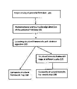
FIG. 1 illustrates a flowchart of a method for automatically extracting a
structural framework from
potential field data according to Embodiment 1 of the present invention.
FIG. 2 illustrates a single-pixel width structural framework map according to
Example 1 of the
present invention.
FIG. 3 illustrates a composite structural framework map according to Example 1
of the present
invention.
FIG. 4 illustrates a structural intensity framework map according to Example 1
of the present
invention.
FIG. 5 illustrates a composite structural intensity framework map according to
Example 1 of the
present invention.
FIG. 6 illustrates a flowchart of a method for automatically extracting a
magnetic structural
framework in a low-latitude area according to Embodiment 2 of the present
invention.
FIG. 7 illustrates a single-pixel width structural framework map according to
Example 2 of the
present invention.
FIG. 8 illustrates a composite structural framework map according to Example 2
of the present
invention.
16
CA 02978500 2017-09-01
FIG. 9 illustrates a structural framework map reflecting cover depth according
to Example 2 of the
present invention.
FIG. 10 illustrates a composite cover depth structural framework map according
to Example 2 of
the present invention.
FIG. 11 illustrates a structural framework map reflecting magnetic intensity
according to Example
2 of the present invention.
FIG. 12 illustrates a composite magnetic intensity structural framework map
according to Example
2 of the present invention.
Description of the Embodiments
In order to better understand the technical solution of the present invention,
the implementation
modes of the present invention will be further described below with reference
to the drawings in
combination with the embodiments, which, however, should not be considered as
limitations to the
present invention.
Embodiment 1
FIG. 1 illustrates a flowchart of a method for automatically extracting a
structural framework from
potential field data according to Embodiment 1 of the present invention. As
illustrated in FIG. 1,
the method comprises the following steps:
In step 101, preprocessing is performed to the measured gravity potential
field data or magnetic
potential field data.
Reduction-to-pole calculation is performed to the magnetic data to obtain the
reduction-to-pole
magnetic anomalies or pseudo-gravity transformation is applied to obtain
pseudo-gravity
anomalies.
17
CA 02978500 2017-09-01
Preprocessing is performed to the gravity data to obtain Bouguer gravity
anomalies.
In step 102, a potential field multidirectional and multiscale edge detecting
method is applied to
the preprocessed gravity potential field data or magnetic potential field data
to obtain edges at a
plurality of scales.
The potential field multidirectional and multiscale edge detecting method
comprises steps of
upward continuing the preprocessed gravity potential field data or magnetic
potential field data for
a plurality of predetermined heights to obtain a plurality of potential field
data at the corresponding
scales, and applying a multidirectional edge detection respectively to the
potential field data at each
scale to obtain a potential field edge at the scale.
The method for applying the multidirectional edge detection respectively to
the potential field data
at each scale comprises the following steps:
A gravity anomaly or magnetic anomaly at Earth surface point (x, y) at height
of zero is defined
as fo(x, y).
Let scale s=z/zo, and z>zo, zo representing measurement height and z
representing the upward
continued height.
A smoothing function for scale s is defined as:
Os (x, y) = s-28
s s
0
,
(x, y) =¨ K (X, , SZ0)
- 2R-
wherein , k(x, y, z) is Green's function.
A wavelet function in direction a is defined as:
18
CA 02978500 2017-09-01
(
C
tg"COS a- + sin a ¨0 0 (x, y) = D" (x, y)
oX
(73y
wherein D represents a first-order derivative.
For the scale s and the location (x, y), the wavelet transform of the gravity
anomaly or magnetic
anomaly fo(x, y) in direction a is defined as:
W" [t} (x, y, s) = fo * y ](x. y)
= f * (sD"9 )
= sD'[fo* 8s]
= sDa fo* ys_
_
wherein * represents convolution operation,
according to a potential field upward continuation formula, it is known that:
fz(x.y) = fo (x, Y) * is, (x, Y)
, and
fz(x, y) is a gravity anomaly or magnetic anomaly via upward continuation
offo(x, y) from height
zero to height z=szo and is obtained by upward continuing the gravity anomaly
or magnetic
anomalyfio(x, y) measured at measurement height zo for height z-zo,
hence,
Wa [Ad (X, 3), s)= spa 11,(x, y)
= (7./ zo)Da f (x, y)
. z ;
=
19
CA 02978500 2017-09-01
Similarly, for the scale s and the location (x, y), wavelet transform of the
gravity anomaly or
magnetic anomalyfo(x, y) in direction a+7-1-2 is defined as:
n-
a a ¨
W 2 [fo](X, S) (Z/ )D 2 (x v)
z
=
Gradient may be used to represent two-dimensional wavelet transform offo(x, y)
as:
Wa s) ( Da Px,y)
W[fo](x, y,s.a) = = / zo
a-- +-
2 Lfoi(X, Y,S)) D 24 (X, y))
W [ fo ](X, ),,s,a)= (z I zo)Vfz (x, y,a)
wherein V is the two-dimensional gradient.
The above equation establishes a relation between the horizontal gradient of
the gravity anomaly
or magnetic anomaly J;(x, y) at any height z (z>zo) and the two-dimensional
directional wavelet
transform of the gravity anomaly or magnetic anomalyfo(x, y) at height zero.
For location (x, y), scale s and direction a, two-dimensional wavelet
transform
W [fo](X, y, s,a) VI,(x, y , a)
of fo(x, y) is in direct proportion to gradient '
offz(x,
W[fo](X, y,S,a)
y), and two-dimensional wavelet transform
offo(x, y) can be represented
by the gradient V=f::.õ(x --y' a) offi(x, y).
Vf (x v , a)
For height z after upward continuation, a modulus of a gradient z
= is defined as:
CA 02978500 2017-09-01
I
a 4--
M { fi(x, y , a) -= Da r (x, y)2 1 + D 2 f (x, y) 2
\ - <, - 11-
/
=
wherein corresponding argument of the gradient along the horizontal direction
is:
( 7r
4f:_(x, )'a) = argument D' .f, (x, ))+ D 2 fz (X, y) /
\ i
, and
defining the point where the modulus M ['fz 1(x, Y, a) is local maximum along
the argument
Af (x, y, a)
direction ' z / as an edge point.
For each height z after upward continuation, different directions a are
selected to calculate,
information about edges in different directions may be highlighted. In order
to achieve complete
coverage of a two-dimensional plane, the direction value a may be taken as
lor/(2n-1), wherein k-----0,
1, 2...(2n-1) and n is an integer greater than or equal to 2. In each
direction, a curve is formed by
connecting the points with local maximum of gradient modulus in a direction
perpendicular to the
gradient to create an edge. For the same height after the upward continuation,
edges are calculated
in directions completely covering the two-dimensional plane, a union of all
the calculated edges is
taken to obtain the edge at the scale.
By performing the above calculation to the potential field data at each scale,
multidirectional edge
detection of the potential field data at each scale can be achieved.
In step 103, the obtained edges at each scale are thinned into single-pixel
width with a
morphological skeleton algorithm to obtain a framework map at each scale.
=
21
CA 02978500 2017-09-01
For the obtained edge images, edges are thinned into single-pixel width by
using an algorithm for
thinning the framework in Thinning Methodologies-A Comprehensive Survey, Lam,
L., Seong-
Whan Lee and Ching Y. Suen, IEEE Transactions on Pattern Analysis and Machine
Intelligence,
v. 14, no. 9, September 1992.
By thinning the obtained edges, the actual geographical range corresponding to
the edges and
intersections of the edges in different directions is significantly reduced
compared with the prior
art, such that the obtained potential field structural framework is closer to
the feature of the actual
geological mapping identified structure. On one hand, map information is clear
and the readability
is enhanced. On the other hand, the geological interpretation is also
facilitated.
In step 104, the obtained structural frameworks at all scales are stacked one
upon the other to
generate a composite structural framework map.
Edges at all scales extracted from the potential field data after upward
continuation for different
heights are stacked one upon the other to obtain a composite structural
framework map of the
potential field of the study area.
Corresponding the different heights after upward continuation of the potential
field to different
depths of source bodies (see A case for upward continuation as a standard
separation filter for
potential-field maps, Jacobsen, B.H., Geophysics, v.52 no.8, 1987), may obtain
structures
corresponding to different depths of the Earth. The frameworks at
corresponding different scales
or different depths are rendered with gradually changing colors and structural
frameworks at all
scales rendered with different gradually changing colors are stacking one upon
the other to
highlight information about structures at different depths. By stacking in
such a way, a composite
structural framework map reflecting information at different depths is
obtained.
In step 105, the gradient modulus of each edge point on the framework at each
scale is used for
reflecting edge intensity.
22
CA 02978500 2017-09-01
[ " a
For different directions a, the gradient modulus M 1,1(
) of each edge point does not change
and is a fixed value. The gradient modulus of the edge point is taken as a
structural intensity value
at this edge point to establish structural intensity framework maps at
different scales or different
depths.
In step 106, the structural intensity framework maps at the plurality of
scales are stacked one upon
the other to generate a composite structural intensity framework map.
By rendering the intensity values of edges at the scales or depths with
different gradually changing
colors and stacking, information of changing intensity of magnetism and
density can be
highlighted.
Example 1
The technical solution of the present invention will be explained by taking
automatic extraction of
a potential field structural framework from aeromagnetic data of West Yunnan
as an example.
Firstly, reduction-to-pole processing is performed in blocks to the
aeromagnetic data, the processed
data are spliced to form a potential field grid file and the size of the grid
is 500m. The aeromagnetic
data in this example is historical one measured and collected in the past in
many times, and the
measurement height is in range of 800-1200m.
Then, upward continuation processing is respectively performed to the spliced
potential field grid
file to obtain potential field data after upward continuation, the upward
continuing heights are
1000m, 1500m, 2000m, 2500m, 3000m, 4000m, 5000m, 10000m, 15000m, 20000m,
25000m and
30000m, respectively, edge detections in thirty-two directions are applied at
each upward continued
height, each direction a is taken a value as 1(7(42'1), wherein k=0, 1, 2,...,
(2n-1) and n=5, and
thereby edges at each scale are obtained.
Then, thinning processing is performed to the resulted edges at each scale
with a skeleton algorithm
to obtain a structural framework map at each scale.
23
CA 02978500 2017-09-01
FIG. 2 illustrates a single-pixel width structural framework extracted at a
corresponding scale to
the height upward continued for 5000m with the edges thinned with the skeleton
algorithm. It can
be seen that the single-pixel width potential field structural framework
automatically extracted by
the method of the present invention is closer to the feature of the actual
geological mapping
identified structure, and thereby the geological interpretation is
facilitated. In addition, the map
information is clearer and the superposition analysis of the frameworks at
different scales is
facilitated.
FIG. 3 illustrates a composite structural framework map formed by rendering
with gradually
changing colors and stacking the frameworks at all scales obtained by edge
detection in thirty-two
directions to the potential field data via upward continuation for heights of
1000m, 1500, 2000m,
2500m, 3000m, 4000m, 5000m, 10000m, 15000m, 20000m, 25000m and 30000m,
respectively.
Corresponding the heights via upward continuation to respective depths of
sources, the composite
structural framework map may be used for representing information about
structural frameworks
at different depths of the study area. Using colors gradually changing from
grey white to black to
represent upward continuation heights from low to high or depths from shallow
to deep, the
composite structural framework map reflects information about structures at
different depths.
FIG. 4 illustrates structural intensity reflected by gradient modulus at edge
points of a framework
obtained after upward continuation for a height of 5000m. Colors changing from
grey white to
black reflect that structural intensity values represented by gradient modulus
increase gradually.
This map reflects structural intensity change corresponding to one scale.
FIG. 5 illustrates a composite structural intensity framework map obtained by
stacking the edge
intensities obtained by upward continuing the potential field data for heights
of 1000m, 1500m,
2000m, 2500m, 3000m, 4000m, 5000m, 10000m, 15000m, 20000m, 25000m and 30000m.
It can
be seen from the mat, at different scales, major structural belts present high
structural intensity and
the corresponding magnetic anomalies change obviously, which indicates that
major structural
24
CA 02978500 2017-09-01
belts all are abrupt change belts of magnetic anomalies, the corresponding
depths are very deep,
and reflects that the structural belts control magmatic ore-forming process at
deep depth.
Furthermore, in FIG. 3 and FIG. 5, structural framework maps with depth and
intensity information
can clearly reflect primary structures of deep depth and long extension in the
area, secondary
structures of shallow depth and short extension, as well as mutual cutting
relations. Therefore, the
structural framework map obtained by the method according to the present
invention can help one
skilled in the art to recognize the structural framework of the surveyed area.
By comparing FIG. 3 and FIG. 5 with the surface mapping geological structure
of this area, the
spatial location and range fit very well, which indicates that the automatic
extraction method
according to the present invention is accurate and effective. In addition, as
compared with the
surface mapping geological structure of this area, structural information
about three-dimensional
extension, intensity and structure is incorporated in FIG. 3 and FIG. 5 of the
present invention,
which may help to identify the hidden structural belts.
Area near the structural belts with deep depths and high structural intensity,
intersection parts of
structures of different directions as well as the turned and curved parts of
the structural belts are
important locations where potential metal ore deposits may be discovered. With
the method
according to the present invention, structural framework maps with depth and
intensity information
can be rapidly and accurately extracted from aeromagnetic data and gravity
data, and help the
explorer's to accurately and rapidly discover potential metal ore deposits.
Embodiment 2
A flowchart of a method for automatically extracting a magnetic structural
framework of a low-
latitude area according to Embodiment 2 of the present invention will be
specially described below
by taking magnetic measure data as an example. One skilled in the art can
understand that the
method provided by the present invention is not limited to be applicable to
automatic extraction of
CA 02978500 2017-09-01
structural frameworks from magnetic survey data and is also applicable to
automatic extraction of
structural frameworks from gravity measure data.
FIG. 6 illustrates a flowchart of a method for automatically extracting a
magnetic structural
framework from a low-latitude area according to the present invention. As
illustrated in FIG. 6, the
method comprises the following steps:
In step 601, preprocessing is performed to measurement values obtained through
magnetic survey,
and Normal Geomagnetic Field (IGRF International Geomagnetic Reference Field)
correction is
performed to obtain Total Magnetic Intensity (TMI) anomaly data.
Gridding is performed to TMI anomaly data, and the grid size is taken as 1/8
to 1/4 of spacing of
the survey lines or a minimum point-to-point distance.
In step 602, the gridded TMI anomaly data T are upward continued for a
plurality of predetermined
heights to obtain a plurality of gridded TMI anomaly data Th at the
corresponding scales, wherein
h represents height after upward continuation.
In step 603, a tilt derivative TDRh of TMI anomaly data at each scale is
calculated by using the
gridded TMI anomaly data Th at the corresponding scale according to the
following formula:
TDRõ = aretan VD
R4
sih"DRit,
wherein VDRh and THDRh respectively represent vertical first-order derivative
and total horizontal
derivative of gridded TMI anomaly data Th:
afrh
DRit
ort, dT,
THDRit (-2-)1
=Ox
al,
26
CA 02978500 2017-09-01
In step 604, multidirectional edge detection based on a horizontal gradient is
applied respectively
to the tilt derivative TDRh at each scale.
Directional derivatives of the tilt derivative TDRh in directions a and a+12
are respectively defined
as:
O
a
DTDRh = (COS a 7¨ Sin a ¨dy)2"DRit
a a Tr \
Cr+
D TaRk (COS(Ct ¨ sin(cc ¨2)¨dy) TDRh
2. OX
wherein D represents a first-order derivative.
For height h and direction a, the horizontal gradient of the tilt derivative
TDRh is represented as:
=
( D"TDRit.
VTDR=(
= D"+r'TDRi
wherein V is horizontal gradient.
VTDR
A modulus of a horizontal gradient f is defined as:
AlTan = IlDff-TDRISz +11)(c+-fTDRd
wherein a corresponding argument of the gradient is:
,Ir
ATDRri' = argument (D9 TR.ri Da'77* h
total horizontal derivative of tilt derivatives (abbr.: TDR THDR) of the TMI
anomaly data is:
27
CA 02978500 2017-09-01
TDRThDR1 MDDRg: , and
the amplitude of the modulus MrpRri, is not related to the magnitude of the
magnetic inclination.
Thus, the point where the modulus mroK is local maximum along the argument
direction ATM
are an edge point of source bodies of magnetic anomalies at height h in
direction a.
In each direction a, the points with local maximum of gradient modulus are
connected in direction
perpendicular to the gradient to obtain a curve to create an edge.
Edges in a plurality of different directions a are calculated at the same
height h and a union of all
the created edges is taken to obtain edges of source bodies of magnetic
anomalies at corresponding
scales.
In order to achieve complete coverage of a two-dimensional plane, the
different direction values a
are respectively taken as lur/(21), wherein k=0, 1, 2...(2n-1) and n is an
integer greater than or
equal to 2.
The TDR calculation performed to the gridded TMI anomaly data may introduce
noise into
calculation results, and the subsequent multidirectional edge detection is
very sensitive to the noise.
In order to prevent noise from influencing multidirectional edge detection,
preferably, noise
reduction processing such as Gaussian filtering is performed to the TDRh data
with high noise
before the multidirectional edge detection is performed.
Since the total horizontal derivatives of the tilt derivatives of the TMI
anomaly data are independent
of the magnetic inclination, the calculation results are not related to the
magnitude of the magnetic
inclination, the edges of source bodies of magnetic anomalies obtained by the
above steps are not
influenced by the magnetic inclination, i.e., are not influenced by latitude
locations of the area to
be analyzed, the structural framework of the low-latitude area can be
accurately represented.
28
CA 02978500 2017-09-01
In step 605, the calculated edges at each scale are respectively thinned into
single-pixel width with
a morphological skeleton algorithm to obtain structural framework maps at a
plurality of scales.
For the calculated edge images, edges are thinned into single-pixel width by
using an algorithm for
thinning the framework in Thinning Methodologies-A Comprehensive Survey, Lam,
L., Seong-
Whan Lee and Ching Y. Suen, IEEE Transactions on Pattern Analysis and Machine
Intelligence,
v. 14, no. 9, September 1992.
By thinning the obtained edges, the actual geographical range corresponding to
the edges and
intersections of edges in different directions is significantly reduced
compared with the prior art,
such that the obtained structural framework is closer to the feature of the
actual geological mapping
identified structure. On one hand, map information is clear and the
readability is enhanced. On the
other hand, the geological interpretation is also facilitated.
In step 606, the obtained structural framework maps at all scales are stacked
one upon the other to
generate a composite structural framework map.
The obtained structural framework maps at all scales are stacked one upon the
other to generate a
composite structural framework map reflecting information at different depths,
and lateral
deviation of edges at different scales on the map reflects information about
attitude of structural
frameworks.
Corresponding the edges extracted from the gridded TMI anomaly data after
upward continuation
for different heights to the structures at different depths, the depth being
half of height after upward
continuation (see A case for upward continuation as a standard separation
filter for potential-field
maps, Jacobsen, B.H., Geophysics, v.52 no.8, 1987), may obtain structural
framework maps
representing different cutting depths. Stacking the obtained structural
framework maps at all depths
one upon the other, may obtain a composite structural framework map reflecting
information at
different cutting depths.
29
CA 02978500 2017-09-01
In step 607, a modulus of a horizontal gradient of TDRh at each edge point on
the structural
framework map at each scale is used to represent a structural cover depth to
obtain structural
framework maps representing structural cover depths at a plurality of scales.
For different directions a, the modulus Al T131:4g of the horizontal gradient
at each edge point does
not change and is a fixed value.
Due to the attribute of the arctan value of the trigonometric function, no
matter how great the
amplitudes of VDRh and THDRh are, the amplitude of TDRh is limited between -
7E/2 and +n/2.
Therefore, the modulus 'IltrDR,Fi= of the horizontal gradient at each edge
point has little correlation
with the amplitude of TMI anomalies, the value reflects the cover depths of
source bodies, the
magnitude of the value is in inverse proportion to the cover depth, and the
bigger the value is, the
shallower the cover depth is (see New Insights into Magnetic Derivatives for
Structural Mapping,
Bruno Verduzco, et al., The Leading Edge, v. 23 no. 2, 2004).
The structural cover depth reflected by the modulus of the horizontal gradient
of the tilt derivative
TDRh represents the thickness of the cover layer above the structural belt,
and different depths
corresponding to upward continuation to a plurality of predetermined heights
reflect the cutting
depth of the structural belt, which represents the downward extension depth of
the structural belt.
The gradient modulus MT 9=R;t1 of each edge point is used for representing the
edge relative cover
depth of the edge point at the scale, to establish structural framework maps
reflecting structural
relative cover depth at different scales or depths. Changes in the values of
the gradient modulus of
the same structural belt reflect cover depths of different parts of the
structural belt.
In step 608, the structural framework maps representing cover depths at the
plurality of scales are
stacked one upon the other to obtain a composite cover depth structural
framework map.
=
CA 02978500 2017-09-01
Modulus values of horizontal gradient of TDRh of edge points at scales or
depths are stacked one
upon the other and rendered with different gradually changing colors to
highlight information about
cover depth changes of structural frameworks of different cutting depth
ranges.
In step 609, a three-dimensional analytic signal ASh is calculated for the
gridded TMI anomaly
data Th at each height according to the following formula:
2
(Oil? (0- Th) `0 "\ 2
AS= 4()
ttx ov uz
The amplitude of the resulted analytic signal ASh has a strong correlation
with the amplitude of
TMI anomalies, but is independent of the magnitude of the magnetic
inclination, and may be used
for indicating locations and magnetic intensity of source bodies of magnetic
anomalies.
In step 610, the ASh value of each edge point on the framework at each scale
is used for indicating
the magnetic intensity of the structure.
Without considering the cover depths of source bodies of magnetic anomalies,
the amplitude of the
three-dimensional analytic signal ASh indicates magnetic intensity of sources
of magnetic
anomalies, and structures with strong magnetism usually have a close relation
with ore formation.
In step 611, the magnetic intensity structural framework maps at the plurality
of scales are stacked
one upon the other to generate a composite magnetic intensity structural
framework map.
ASh values of edge points at the scales or depths are rendered with gradually
changing colors and
stacked one upon the other to highlight information about magnetic intensity
changes of structural
frameworks in range of different depths.
Example 2
31
CA 02978500 2017-09-01
The technical solution of the present invention will be explained below by
taking automatic
extraction of a magnetic structural framework from high-precision aeromagnetic
data of Guyana
Shield in South America in low-latitude area as an example.
Survey scale of aeromagnetic data used in this example is 1:25000 and
measurement height is in
range of 70-120m.
Firstly, preprocessing is performed to the measurement values obtained through
aeromagnetic
survey of the study area, Normal Geomagnetic Field (IGRF International
Geomagnetic Reference
Field) correction is performed to obtain Total Magnetic Intensity (TMI)
anomaly data, and gridding
is performed to the TMI anomaly data, wherein the grid size is about 10m.
Then, upward continuation processing is respectively performed to the gridded
TMI anomaly data
to obtain gridded TMI anomaly data Ti, at a plurality of scales, wherein
upward continuation heights
are 100m, 200m, 300m, 400m and 500m, respectively.
TDR calculation is performed to the gridded TMI anomaly data Ti, at each
scale.
For each upward continuation height, multidirectional edge detection based on
a horizontal
gradient is respectively performed to the calculated TDR at each height after
upward continuation.
Edge detection in sixty-four directions is performed to each TDR calculation
result and different
direction values a are taken as lot/(2n-1) respectively, wherein k=0, 1,
2...(2n-1) and n=6, so as to
obtain a edges at each scale.
Then, thinning processing is performed to the resulted edges at each scale
with the skeleton
algorithm to obtain a structural framework map at each scale.
FIG. 7 illustrates a single-pixel width magnetic structural framework at a
corresponding scale
obtained by extracting from the gridded TMI anomaly data after upward
continuation for a height
of 300m and the edges are thinned with the skeleton algorithm. It can be seen
that the single-pixel
width structural framework automatically extracted by the method of the
present invention is closer
32
CA 02978500 2017-09-01
to the feature of the actual geological mapping identified structure, and
thereby the geological
interpretation is facilitated. In addition, the map information is clearer and
the superposition
analysis of the structural frameworks at different scales is facilitated.
FIG. 8 illustrates a composite structural framework map formed by rendering
with gradually
changing colors and stacking the frameworks at all scales obtained by edge
detection in sixty-four
directions to the gridded TMI anomaly data after upward continuation for
heights of 100m, 200m,
300m, 400m and 500m. Corresponding the heights via upward continuation to the
depths of source
bodies, the composite structural framework map may be used for representing
information about
structural frameworks at different depths of the study area. Using colors
gradually changing from
grey white to black to represent upward continued heights from low to high or
depths from shallow
to deep, and the composite structural framework map reflects information about
structures at
different cutting depths.
Then, the gradient modulus of TDRh at each edge point on a framework at each
scale is calculated
for representing structural cover depth. FIG. 9 illustrates structural cover
depths represented by the
gradient modulus at edge points of a framework upward continued for an height
of 300m, and
colors gradually changing from grey white to black reflect that structural
cover depths represented
by modulus of a horizontal gradient gradually decrease. This map reflects
structural cover depth
changes at a corresponding scale.
Then, the structural framework maps at the plurality of scales, which
represent the relative cover
depths, are stacked one upon the other to generate a composite cover depth
structural framework
map. FIG. 10 illustrates a composite cover depth structural framework map
obtained by stacking
the obtained structural framework maps representing relative cover depths
after upward continuing
the gridded TMI anomaly data for heights of 100m, 200m, 300m, 400m and 500m.
It can be seen
from the map, at different scales, cover depths of major structural belts
change obviously, usually
the structures at deeper cover depths, i.e., with thicker cover layers, has
lower value of TMI
33
CA 02978500 2017-09-01
anomalies, and the structures are hidden structures and thus this method
facilitates the identification
of hidden structures.
Then, a three-dimensional analytic signal ASh is calculated for the gridded
TMI anomaly data at
each scale. The value of the resulted analytic signal ASh is independent of
the magnitude of the
' magnetic inclination, and can be used for indicating locations and magnetic
intensity of source
bodies of magnetic anomalies.
In this example, the ASh value of each edge point on the framework at each
scale is used for
indicating the magnetic intensity of the structure. FIG. 11 illustrates a
structural framework map
with the ASh values indicating the magnetic intensity of edges points of the
framework upward
continued for a height of 300m, and colors gradually changing from grey white
to black represent
that magnetism of structural belts indicated by analytic signal ASh values
gradually increases.
Then, the magnetic intensity structural framework maps at the plurality of
scales are stacked one
upon the other to generate a composite magnetic intensity structural framework
map. As illustrated
in FIG. 12, ASh values of the edges at all scales or depths are stacked one
upon the other and
rendered with the colors gradually changing from grey white to black to
highlight information
about magnetism changes of structural frameworks at different depths.
Without considering the cover depths of source bodies, the amplitude of the
three-dimensional
analytic signal ASh indicates magnetic intensity of sources of magnetic
anomalies, and structures
with strong magnetism usually have a close relation with ore formation.
In addition, by observing FIG. 8 and FIG. 10, structural framework maps with
information about
the cutting depth and intensity may clearly reflect primary structures of deep
depths and long
extension in the area, secondary structures of shallow depths and short
extension, cover depths of
the structures as well as mutual cutting relations. Therefore, the structural
framework map obtained
by the method according to the present invention can help one skilled in the
art to recognize the
structural framework of the surveyed area.
34
CA 02978500 2017-09-01
Area near the structural belts with strong magnetism and deep depths,
intersection parts of
structures of different directions, as well as the turned and curved parts of
the structural belts are
important locations where potential metal ore deposits may be discovered. With
the method
according to the present invention, structural framework maps with information
about cutting
depth, cover depth, magnetic intensity, primary and secondary relation,
cutting relation and the like
can be rapidly and accurately extracted from magnetic measure data, and help
the explorers to
accurately and rapidly discover potential metal ore deposits.
The present invention has been described above in detail in combination with
the preferred
embodiments. However, the present invention is not limited thereto. One
skilled in the art may
make various modifications according to the principle of the present
invention. Therefore,
modifications made according to the principle of the present invention shall
be all understood as
included in the protection scope of the present invention.