Note: Descriptions are shown in the official language in which they were submitted.
International Application Number: AU2016050500
CA 02989335 2017-12-13
Article 34 Amendments
submitted with Demand for IPEA dated 18 Apr 2017
H.Nenka \InterworelANRPortbMICCIMICA \1404301:18_2.docx-18/04f2017
¨ 1 -
SOIL CONDITION ANALYSIS SYSTEM AND PROCESS
TECHNICAL FIELD
The present invention relates to a soil condition analysis system and process,
and in
particular to a system and process that measure soil properties and use
mathematical and
statistical methods to derive the condition of soil as a function of depth.
BACKGROUND
Information on the condition of soils is needed to address environmental
concerns over
food production, water and energy securities, land degradation, and climate
change. It is
also needed for the long-term provision of ecosystem function and ecosystem
services,
which are important for human well-being and economic development. However,
although
soils are central to these concerns, not enough is known about their
properties,
composition, functions, diversity and distributions. The main reason is that
soil science has
been constrained by the inconvenience and high costs of existing soil
measurement
methods, including outdated and on occasions imprecise laboratory techniques,
and the
need to measure at depth down to the root zone or deeper.
It is desired to provide a soil condition analysis system and process that
alleviate one or
more difficulties of the prior art, or to at least provide a useful
alternative.
SUMMARY
In accordance with some embodiments of the present invention, there is
provided a soil
condition analysis system, including:
a support platform to support an elongate soil core extracted from the Earth;
a plurality of soil sensing components configured to measure corresponding
characteristics of a soil core supported on the support platform, including a
camera to
image the soil core, an optical spectrometer to measure light from the soil
core at near-
infrared and/or mid-infrared wavelengths, and a gamma ray attenuation
component to
measure attenuation of gamma-rays transmitted through the soil core;
AMENDED SHEET
IPEA/AU
International Application Number: AU2016050500
CA 02989335 2017-12-13
Article 34 Amendments
submitted with Demand for I PEA dated 18 Apr 2017
H.Nenka \InterworelANRPortbMICCIMICA \1404301:18_2.docx-18/04f2017
- 2 -
one or more data acquisition components in communication with the soil sensing
components and configured to generate measurement data representing the
measured
characteristics from the soil sensing components; and
a data processing component configured to process the measurement data to
generate soil property data representing corresponding soil properties of the
elongate soil
core as a function of depth, based on spectroscopic models representing
relationships
between the soil properties and the measured characteristics;
wherein at least one of the support platform and the plurality of soil sensing
components is mounted on a computer-controlled translation stage to enable the
soil
sensing components to automatically measure the corresponding characteristics
of the soil
core at mutually spaced locations along a longitudinal axis of the elongate
soil core;
wherein the data processing component is configured to generate estimates of
the
bulk density of the soil core as a function of depth from the measured
attenuation of
gamma rays through the soil core and the measured water content of the soil
core by
compensating for the absorption of the gamma rays by the water content of the
soil core to
generate estimates of the bulk density of the soil core without the water
content;
wherein the water content of the soil core is determined from spectroscopic
modelling of visible¨near infrared spectra measured from the soil core.
In some embodiments, the soil sensing components include a long wave infrared
(LWIR)
camera.
In some embodiments, the soil sensing components include an x-ray sensor
component to
measure x-ray fluorescence of the soil or x-ray transmission through the soil
core.
In some embodiments, the soil sensing components include at least one of a
microwave
soil water sensing component and a laser induced breakdown spectroscopy (LIBS)
sensing
component.
In some embodiments, the soil condition analysis system includes a display
component to
display, during data acquisition, a visual image of at least a corresponding
portion of the
AMENDED SHEET
IPEA/AU
International Application Number: AU2016050500
CA 02989335 2017-12-13
Article 34 Amendments
submitted with Demand for IPEA dated 18 Apr 2017
H.Nenka \InterworelANRPortbMICCIMICA \1404301:18_2.docx-18/04f2017
- 3 -
soil core, together with measurement data being acquired from at least one
other of the soil
sensing components.
In some embodiments, the soil properties includes at least five of: soil
organic carbon,
organic carbon composition (particulate, humic, and resistant carbon), bulk
density, soil
carbon stocks, soil water, available water capacity, clay content, iron
mineralogies, soil
colour, clay mineralogies, cation exchange capacity, total nitrogen, and pH.
In some embodiments, the spectroscopic models are generated by machine
learning
applied to a soil spectral library of previously measured soil spectra and
corresponding soil
properties.
In some embodiments, the spectroscopic models are generated by analysing a
representative subset of a plurality of soil cores taken from a common
geographic region to
be analysed to determine the soil properties of the subset of soil cores by
laboratory
analysis, and associating the determined soil properties with corresponding
spectra from
the subset of soil cores; using the relationships between the determined soil
properties and
corresponding spectra to customise a soil spectral library of previously
measured soil
spectra and corresponding soil properties by removing those members of the
soil spectral
library that are least representative of the subset of soil cores and adding
the determined
soil properties and corresponding spectra of the subset of soil cores to the
remaining
members of the soil spectral library to provide a soil spectral library
customised to the
common geographic region; and generating the spectroscopic models from the
customised
soil spectral library.
In some embodiments, the members of the soil spectral library are removed by
iteratively
removing corresponding members of the soil spectral library that are least
representative of
the subset of soil cores as determined by a corresponding partial least
squares regression
performed in each iteration. In some embodiments, a fixed proportion of the
remaining
number of members of the soil library are removed in each iteration.
AMENDED SHEET
IPEA/AU
International Application Number: AU2016050500
CA 02989335 2017-12-13
Article 34 Amendments
submitted with Demand for IPEA dated 18 Apr 2017
H.Nenka \InterworelANRPortbMICCIMICA \1404301:18_2.docx-18/04f2017
- 4 -
In some embodiments, the representative subset of soil cores is selected by
the Kennard-
Stone method.
In some embodiments, the support platform, soil analysis components, and data
acquisition
components are mounted on a trailer such that the system can be transported to
a site
where soil cores are to be extracted for measurement by the system.
In accordance with some embodiments of the present invention, there is
provided
using a soil condition analysis system to generate measurement data
representing measured
characteristics of an elongate soil core at mutually spaced locations along a
longitudinal
axis of the elongate soil core by controlling a computer-controlled
translation stage to
automatically translate at least one of a support platform on which the soil
core is
supported and a plurality of soil sensing components configured to measure
corresponding
characteristics of the soil core, the plurality of soil sensing components
including a camera
to image the soil core, an optical spectrometer to measure light from the soil
core at near-
infrared and/or mid-infrared wavelengths, and a gamma ray attenuation
component to
measure attenuation of gamma-rays transmitted through the soil core;
processing the measurement data to generate soil property data representing
corresponding soil properties of the elongate soil core as a function of
depth, based on
spectroscopic models representing relationships between the soil properties
and the
measured characteristics, including determining water content of the soil core
from
spectroscopic modelling of visible¨near infrared spectra measured from the
soil core; and;
generating estimates of the bulk density of the soil core from the measured
attenuation of
gamma rays through the soil core and the determined water content of the soil
core by
compensating for the absorption of the gamma rays by the water content of the
soil core to
generate estimates of the bulk density of the soil core without the water
content.
In some embodiments, the process includes applying machine learning to a
spectral library
of previously measured soil spectra and corresponding soil properties to
generate the
spectroscopic models.
AMENDED SHEET
IPEA/AU
International Application Number: AU2016050500
CA 02989335 2017-12-13
Article 34 Amendments
submitted with Demand for IPEA dated 18 Apr 2017
H.Nenka \InterworelANRPortbMICCIMICA \1404301:18_2.docx-18/04f2017
- 5 -
In some embodiments, the spectroscopic models are generated by analysing a
representative subset of a plurality of soil cores taken from a common
geographic region to
be analysed to determine the soil properties of the subset of soil cores by
laboratory
analysis, and associating the determined soil properties with corresponding
spectra from
the subset of soil cores; using the relationships between the determined soil
properties and
corresponding spectra to customise a soil spectral library of previously
measured soil
spectra and corresponding soil properties by removing those members of the
soil spectral
library that are least representative of the subset of soil cores and adding
the determined
soil properties and corresponding spectra of the subset of soil cores to the
remaining
members of the soil spectral library to provide a soil spectral library
customised to the
common geographic region; and generating the spectroscopic models from the
customised
soil spectral library.
In some embodiments, the customising of the soil library includes iteratively
removing
members of the soil library that are least representative of the subset of
soil cores as
determined by a partial least squares regression.
In some embodiments, a fixed proportion of the remaining number of members of
the soil
library are removed in each iteration.
In some embodiments, the representative subset of soil cores is selected by
the Kennard-
Stone method.
In some embodiments, the soil properties includes at least five of: soil
organic carbon,
organic carbon composition (particulate, humic and resistant organic carbon),
bulk density,
soil carbon stocks, soil water, available water capacity, clay content, total
nitrogen, iron
mineralogies, clay mineralogies, soil colour, cation exchange capacity, and
pH.
In accordance with some embodiments of the present invention, there is
provided at least
one computer-readable storage medium having stored thereon executable
instructions that,
AMENDED SHEET
IPEA/AU
International Application Number: AU2016050500
CA 02989335 2017-12-13
Article 34 Amendments
submitted with Demand for IPEA dated 18 Apr 2017
H.Nenka \InterworelANRPortbMCCIMICA \1404301:18_2.docx-18/04f2017
- 6 -
when executed by at least one processor of a data processing system, cause the
at least one
processor to execute any one of the above processes.
Also described herein is a soil measurement system, including:
a support platform to support an elongate soil core extracted from the Earth;
a plurality of soil analysis components configured to measure respective
properties
of a soil core on the support platform;
data acquisition components configured to acquire, from the soil analysis
components, measurement data representing the soil properties measured by the
soil
analysis components;
wherein at least one of the support platform and the plurality of soil
analysis
components is mounted on a computer-controlled translation stage to enable the
soil
analysis components to automatically measure the properties of the soil core
at respective
locations along a longitudinal axis of the elongate soil core.
The soil analysis components may include a camera to image the soil core at
visible
wavelengths, a camera to image the soil core at thermal wavelengths, an
optical
spectrometer to measure light from the soil core at near-infrared or mid-
infrared
wavelengths, and a gamma ray attenuation component to measure attenuation of
gamma-
rays transmitted through the soil core.
The soil measurement system may include a data processing component configured
to
generate measurements of the bulk density of the soil core by measuring the
attenuation of
gamma rays through the soil core and the water content of the soil core, and
compensating
for the absorption of the gamma rays by the water content of the soil core to
generate
estimates the bulk density of the soil core without the water content.
AMENDED SHEET
IPEA/AU
CA 02989335 2017-12-13
WO 2016/201508 PCT/AU2016/050500
- 7 -
Also described herein is a soil measurement process, including:
receiving sample gamma attenuation data representing the measured attenuation
of
gamma rays through a soil sample;
receiving optical spectral data representing measured visible¨near infrared
optical
spectra from the soil sample;
processing the optical spectral data to generate water content data
representing
water content of the soil sample;
processing the sample gamma attenuation data and the water content data to
generate soil gamma attenuation data representing the attenuation of gamma
rays through
the soil sample without the water content; and
processing the soil gamma attenuation data to generate bulk density data
representing the bulk density of the soil sample.
The soil measurement process may include processing the optical spectral data
and the
sample gamma attenuation data to generate at least five soil attribute depth
functions to
determine soil condition data representing estimates of at least five of: soil
organic carbon,
organic carbon composition (particulate, humic and resistant organic carbon),
bulk density,
soil carbon stocks, soil water, clay content, total nitrogen, iron
mineralogies, clay
mineralogies, soil colour, cation exchange capacity, and pH.
- 8 -
BRIEF DESCRIPTION OF THE DRAWINGS
Some embodiments of the present invention are hereinafter described, by way of
example only,
with reference to the accompanying drawings, wherein:
Figure 1 is a block diagram of a soil condition analysis system in accordance
with an
embodiment of the present invention;
Figure 2 is a flow diagram of a soil condition analysis process in accordance
with an
embodiment of the present invention;
Figure 3 includes plan, front, side, and perspective views of a soil core
multisensor
platform of the system;
Figure 4 is a diagram showing the components and connections of a power and
multi sensor measurement control sub-system of the soil core multisensor
platform of
Figure 3. For clarity, Figure 4 is further depicted in magnified form by
Figures 4A, 4B,
4C and 4D;
Figure 5 is a block diagram showing the relationships between the hardware
components
of the soil core multisensor platform and software components of the system;
Figures 6 and 7 are CAD drawings of a base component of the soil core
multisensor
platform with its drawers open and closed, respectively;
Figure 8 is a CAD drawing of a hood component of the soil core multisensor
platform,
shown from the rear with access flaps open;
Figure 9 is a CAD drawing of the hood component mounted to the base component
to
form an enclosure for the soil core multisensor platform;
Figure 10 is a CAD drawing of the soil core multisensor platform installed
within the
enclosure of Figure 9;
Figure 11 is a CAD drawing showing a computer mounting platform within a front
right-hand draw of the base of the enclosure;
Figure 12 is a flow diagram of a soil core multisensor platform measurement
process of
the process of Figure 2;
7604603
Date Recue/Date Received 2022-06-20
CA 02989335 2017-12-13
WO 2016/201508 PCT/AU2016/050500
- 9 -
Figure 13 is a screenshot of a graphical user interface (GUI) screen of the
system,
as displayed to an operator of the system when setting up a new measurement;
Figure 14 is a screenshot of a "measurement settings" screen of the system;
Figure 15 is a screenshot of a "measurement" screen of the system displayed to
the
operator during the measurement of a soil core, showing a photographic image
of the soil
core with an indicator showing the current depth/location along the core being
analysed,
above which is displayed an analysis spectrum for that depth/location;
Figure 16 is a block diagram of a control computer of the system; and
Figure 17 is a pair of photographic images showing a contact probe soil core
attachment of the system moving from a raised position (left-hand image) to
being in direct
contact with (right-hand image) an elongate soil core disposed between a gamma
radiation
source and a gamma ray detector of the system;
Figure 18 is a block diagram showing ROS nodes of the system and their
distribution between two computer systems in accordance with an alternative
embodiment
of the system;
Figure 19 is a state diagram showing the various operating states of the
system of
the alternative embodiment;
Figure 20 includes an acquired photographic image along a soil core (extreme
left),
a corresponding depths profile of gamma rays passing through the soil core to
the gamma
ray detector (indicative of bulk density), and corresponding visible¨NIR
spectra acquired
at different depths along the soil core (and used to estimate water content
and other soil
properties at different depths);
Figure 21 is a set of graphs of cation exchange capacity (CEC), clay content,
and
organic carbon content and uncertainties as a function of depth along a soil
core,
demonstrating the filtering of the soil property profiles and their improved
accuracy, as
determined by the system;
Figures 22 and 23 are respectively first and second sets of 14 graphs of
various soil
properties as a function of depth for particular first and second soil cores,
respectively, as
determined by the system;
CA 02989335 2017-12-13
WO 2016/201508 PCT/AU2016/050500
- 10 -
Figure 24 is a set of three photographs showing the soil core measuring
component
mounted on a trailer and being used on site to measure characteristics of soil
cores; and
Figure 25 is a flow diagram of a soil core data analysis process of the
system.
DETAILED DESCRIPTION
As shown in the embodiment of Figure 1, a soil condition analysis system 100
includes a
soil core measuring component 102 and a soil data analysis component 104. The
system
100 executes a soil condition analysis process, as shown in Figure 2, that
measures a range
of soil characteristics as a function of depth along the length of a soil
core, and processes
the resulting measurement data to determine soil property depth functions to
assess soil
condition. The soil properties include at least five of soil organic carbon
content, organic
carbon composition (particulate, humic and resistant carbon), bulk density,
soil carbon
stocks, soil water, available water capacity, clay content, total nitrogen,
iron and clay
mineralogies, soil colour, cation exchange capacity, and pH.
The soil core measuring component 102 includes sensing and analysis hardware
components 106, a power (electrical and pneumatic), safety interlock, control
and data
acquisition sub system 108, and a control computer 110 coupled to a
touchscreen display
device 112. There is a separate PILZ (https://www.pilz.comJen-AU/) safety
system which
runs in parallel with the main Computer touch screen. In particular, we have a
PILZ safety
relay that overseas the safety aspects of the system.
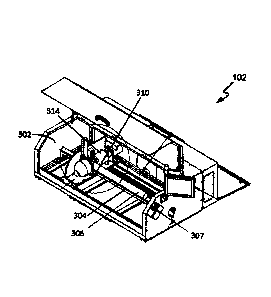
As shown in Figure 3, the sensing and analysis hardware components 106 include
an
elongate housing 302 having an elongate support bed or platform 304 to support
a soil core
306 in a generally horizontal orientation. In the described embodiments, the
support
platform 304 can accommodate soil cores 306 having lengths up to 1.5 m and
diameters in
the range from about 50 mm to 85 mm; however, it will be apparent to those
skilled in the
art that in other embodiments the system 100 can be configured to accommodate
soil cores
having essentially any practical dimensions.
CA 02989335 2017-12-13
WO 2016/201508 PCT/AU2016/050500
- 11 -
As shown in Figure 4, the operator is protected using a safety interlock relay
system (Pilz,
PNOZ S4). The safety interlocks include an e-stop switch 307, a multisensor
measurement
platform enable button to reset the safety interlock and a sensor to detect
closure of the
multisensor platform door. The interlocks disable operation of the linear
translation stage
310 (linear actuator) via the servo drive and pneumatic components related to
operator
safety e.g. where the sensor components 308 include an active gamma ray
attenuation
sensor, the pneumatically operated protective shutter of the gamma ray source
is not
opened when interlocks are active.
Soil analysis components 308 are mounted to a linear translation stage 310
that allows the
analysis components 308 to be moved to any desired location along the entire
length of the
soil core 306 by way of a linear actuator (partially visible in the isometric
drawing in
Figure 3), with the associated cables supported by a cable train. The linear
actuator is
under control of the computer 110 via a servo drive (Copely Controls ¨
Accelnet) with
encoder feedback. Typically, this is used to automatically translate the stage
310 along the
entire length of the soil core 306 in a continuous or stepwise manner,
acquiring data from
the analysis components 308 while the stage 310 is moving or is stationary
between
successive translation steps, in order to acquire data at many locations along
the length of
the soil core 306. Optical proximity sensors (not shown) are mounted on the
linear
translation stage 310 to determine the absolute position and length of the
soil core 306 on
the support platform 304.
The soil analysis components 308 include different types of analysis
components in order
to acquire respective types of analysis data and thereby more comprehensively
characterise
the composition and structure of the soil core 306. In the described
embodiments, the soil
analysis components 308 include at least an active gamma ray attenuation
sensor (an
LB444 sensor from Berthold Technologies GmbH, Germany), a visible to near-
infrared
(vis¨NIR) optical spectrometer and contact Probe (both from PANalytical,
formerly
Analytical Spectral Devices Inc. (ASDI), Boulder, Colorado USA), and a digital
camera
(Logitech C920). In some embodiments, the system 100 also includes one or more
of an X-
Ray Fluorescence (XRF) analysis component for soil elemental analysis, an X-
Ray
CA 02989335 2017-12-13
WO 2016/201508 PCT/AU2016/050500
- 12 -
transmission (attenutation) sensor, a mid-infrared (MIR) spectrometer, a
microwave soil
water analysis component, and/or a laser induced breakdown spectroscopy (LIES)
analysis
component.
The contact probe illuminates a spot of diameter 10 mm with high intensity
halogen light
bulb (2901 10K) to reduce errors arising from stray light entering the
spectrometer. As
shown in Figure 17, the system 102 includes an attachment 1702 for the contact
probe
1704 that prevents the window of the probe 1704 from coming into contact with
the soil
core 1706 and for additional optical shielding. The attachment which can be
made
manually with PVC or 3D printed from Nylon, includes a part-cylindrical shell
whose
inner curvature matches the outer curvature of the soil core 1706. In use, the
probe 1704
with attachment 1702 drops down pneumatically until it comes into contact with
the soil
core1706 so that the contact probe 1704 is positioned close to the surface of
the soil core
1706.
In the described embodiments, the gamma ray sensor is an LB444 sensor from
Berthold
Technologies GmbH, Germany, and is used to make gamma-ray attenuation
measurements
of soil bulk density, as described below. The sensor includes a shielded 137
Cs gamma ray
source 1708 having an activity of 185 MBq and emitting gamma rays with an
energy of
0.662 MeV. The source 1708 is equipped with a pneumatically operated shutter
that is
controlled with the multisensor platform's safety interlock. The detector 1710
is an
LB5441-01 (Berthold Technologies 135 GmBH, Gennany) with an uncollimated NaI
scintillation crystal of 25 mm diameter and 25 mm length. As shown in Figure
17, the
source 1708 and detector 1710 are positioned on opposite sides of a soil core
1706 to
enable measurements of the attenuation of gamma rays passing through the core
1706
along paths traversing thin circular disk portions of each cylindrical soil
core.
In the described embodiments, the control computer 110 is a computer system
such as an
Intel IA-64 based computer system, as shown in Figure 16, and the processes
executed by
the system 100 are implemented as programming instructions of software modules
1602
stored on non-volatile (e.g., hard disk or solid-state drive) storage 1604
associated with the
CA 02989335 2017-12-13
WO 2016/201508 PCT/AU2016/050500
- 13 -
computer system, as shown in Figure 3. However, it will be apparent that in
other
embodiments, at least portions of the processes could alternatively be
implemented as one
or more dedicated hardware components, such as application-specific integrated
circuits
(ASICs) and/or as configuration data of one or more field programmable gate
arrays
(FPGAs), for example. It will also be apparent to those skilled in the art
that in other
embodiments the various components of the control computer 110 may be
distributed
and/or combined in a variety of alternative ways other than those described
herein, and/or
at a number of alternative locations.
The control computer 110 includes standard computer components, including
random
access memory (RAM) 1606, at least one processor 1608, and external interfaces
1610,
1612, 1614, all interconnected by at least one bus 1616. The external
interfaces include
universal serial bus (USB) interfaces 1610, a network interface connector
(NIC) 1612
which provides Ethernet connectivity, an RS-232 interface 1614, and a display
adapter
1616, which is connected to a display device such as a touchscreen LCD panel
display
1622.
The control computer 110 also includes a number of standard software modules
1626 to
1630, including an operating system 1624 such as Linux, robotic operating
system (ROS)
components 1626, available from the ROS web site at lutp://www.ros.ora, and
Python
programming language support 1628, available from http://www.python.org. As
known to
those skilled in the art, the ROS software framework enables robotic control
applications
to be implemented as a distributed network of executable components referred
to as
"nodes" that communicate with one another via IP-based publish and subscribe
messaging.
In the described embodiments, the processes executed by the system 100 are
implemented
as ROS packages 1630 written in Python and C++ to implement respective ROS
nodes 502
to 514, as described below. Each node can subscribe to one or more "topics"
and then
receive messages published to those topics by other nodes.
In the system 100, each of the soil analysis components 308 interfaces with a
corresponding ROS software node which publishes data into the
publish/subscribe
CA 02989335 2017-12-13
WO 2016/201508 PCT/AU2016/050500
- 14 -
network, and a controller node 512 manages all the data collection. Whilst a
measurement
is running, the controller node builds an in-memory data structure of all
samples and then
saves this data to disk in open format YAML files for processing by other
applications.
In the embodiment of Figure 5, the ROS architecture of the system 100 includes
the
following seven nodes:
(i) accelnet node 502 (to control the linear translation stage);
(ii) uvc capture node 504 (digital image capture from USB camera);
(iii) advantys node 506 (ADC and digital i/o);
(iv) gamma node 508 (gamma density sensor);
(v) asd labspec node 510 (vis¨ NW spectrometer);
(vi) scanner controller node 512 (central controller, data management,
sampling); and
(vii) gui_desktop node 514 (user interface, visualisation).
In the described embodiments, the soil core measurement system 100 is mounted
within a
protective enclosure, as shown in Figures 3 and 6 to 10. The enclosure
includes a base
component 600, as shown in Figures 6 and 7, onto which the soil measurement
system 100
is mounted via rubber vibration isolation components. The base component 600
includes
storage compartments in the form of sliding drawers, for storing core samples
and general-
purpose storage, including a storage compartment for a generator and
compressor:
Generator Honda EP2200CX and compressor Maxus CFIWX1001. A hood component
800, as shown in Figure 8, sits on top of the base component 600, as shown in
Figure 9, in
order to protect the system 100 from the elements. The hood component 800
includes rear
flaps 802 that are operable to allow access to the power and multisensor
platform control
sub-system 108.
Figure 10 shows the elongate housing 302 of the sensing and analysis hardware
components 106 installed within the enclosure, and a transparent access door
of the
enclosure in an open position in order to allow access to the soil core and
soil analysis
components 308.
CA 02989335 2017-12-13
WO 2016/201508 PCT/AU2016/050500
- 15 -
Figure 11 is a close-up of the front right-hand storage compartment of the
base component
600, showing an optional articulated arm to which the touchscreen display
device 112 can
be mounted in some embodiments.
In the described embodiments, the enclosure is mounted on a wheeled trailer as
shown in
Figure 24, which allows the soil core multisensor platform measurement
component 102 to
be towed by a vehicle to essentially any desired location that can be accessed
by a vehicle.
In particular, the resulting portability of the soil core multisensor platform
measurement
component 102 allows it to be transported to locations or sites where soil
cores are to be
extracted, allowing immediate analysis of extracted soil cores and avoiding
any
requirements to transport the soil cores (which can induce structural and
compositional
(biochemical) changes in the soil) and thus reducing any changes in structure
and/or loss of
water content or other constituents from the soil cores. In some embodiments,
the soil core
multisensor platfolin component 102 includes a 3G or 4G mobile
telecommunications
network interface so that the operation of the system 100 can be controlled
remotely, and
the data acquired and/or generated by the soil core multisensor platform
component 102
can be transmitted to cloud storage and/or the soil data analysis component
104 for real
time analysis.
As shown in the flow diagram of Figure 2, the system 100 is used to assess
soil properties
that determine soil organic carbon stocks and soil condition as a function of
depth by
analysing the sensor or measurement data recorded from the soil cores that are
extracted
from the ground at selected sampling locations of a region of interest (e.g.,
a farm
property), using a drilling rig to extract the soil cores at step 202. In the
described
embodiments, intact soil cores with a diameter between about 45 to 85 mm are
extracted.
The extraction can be performed using, for example, a core extractor in the
form of a push-
tube (e.g., of a GeoprobeTM 7822DT drilling rig and DT325 sampling system with
sample
liners from Geoprobe, Salina, Kansas, geoprobe.com). Each soil core can be
sampled
directly into a plastic liner within the push-tube. A longitudinal section of
the liner is
removed using a cutting tool (e.g. a GeoprobeTM DT325 liner cutter) to expose
the soil core
surface prior to analysis. If the soil cores are to be transported to a remote
location for
CA 02989335 2017-12-13
WO 2016/201508 PCT/AU2016/050500
- 16 -
analysis, then the plastic core liner is left in-tact and sealed using end
caps the plastic core
liner is left intact and sealed using end caps. Alternatively, when using
other coring
systems, the soil core is removed from the push tube and slid into an elongate
tube of thin
plastic to prevent the soil core from drying out prior to analysis.
Alternatively, each soil
core can be extracted into a corresponding length of PVC pipe that has been
halved
longitudinally, and then the soil core and pipe wrapped in plastic to prevent
moisture loss
during transport. However, the portability of the soil core multisensor
platform component
102 allows it to be transported to the region of interest so that each soil
core extracted from
that region can be immediately placed in the soil core multisensor platform
component 102
and analysed without delay, if desired.
At step 204, an extracted soil core is received by the soil core multisensor
platform
component 102 by carefully placing it on the support bed or platform 304 in a
horizontal
orientation. At step 204, an operator of the soil core multisensor platform
component 102
then enters desired core measurement parameters into the soil core multisensor
platform
component 102 by way of the touchscreen device (or keypad/keyboard input
device, as the
case may be) 112.
Figure 13 is a screenshot of the initial graphical user Interface (GUI) or
start screen 1300
displayed on the touchscreen device 112 when the system 100 is ready to
commence a new
measurement. The start screen 1300 includes text boxes 1302 that allow an
operator of the
system 100 to enter text data defining a name of the project of which this
particular soil
multisensor measurement is a part, the name of the site from which the soil
core was
extracted, the name or identifier of the operator, and the name or identifier
of the particular
soil core that is about to be measured. The "Calibrate Gamma" button control
1304 allows
the operator to automatically calibrate the gamma ray attenuation sensor
(typically, the
radiometer is only calibrated once per day, prior to performing the first soil
core
measurement of that day). In embodiments where additional
sensors/detectors/spectrometers/analysis components are included, the start
screen 1300
includes additional button controls for calibrating the corresponding
components, where
calibration is required. The start screen visibly displays the status of the
soil core
CA 02989335 2017-12-13
WO 2016/201508 PCT/AU2016/050500
- 17 -
mutisensor measurement system such as the state of the safety interlocks,
supply air
pressure and up-to-date sensor calibration. These conditions must be satisfied
before the
system allows a core measurement to be commenced.
A "sensor measurement settings" button control 1308, when touched (or pressed
or
clicked, as the case may be in other embodiments where an input device other
than a
touchscreen is used to provide input) by the operator, causes the touchscreen
device 11 to 2
display a "sensor measurement settings" GUI or screen 1400, as shown in Figure
14,
which allows the operator to leave default values or define technical
parameters of the core
measurements, including the depth resolution (i.e., translation stage step
size) and analysis
parameters for each of the soil analysis components 308.
Alternatively, the operator can override the uniform step size using a
'sampling plan' text
file that provides a list of values with the desired absolute measurement
position on the
core specified individually for each sensor. This can be used to optimise the
soil core
sensor measurement process for detail (resolution) and measurement time. For
example,
the analysis locations might be at equidistant positions along the soil core,
or alternatively
may vary with position/depth (e.g., measure every 1 cm from the surface to 30
cm, then
every 5 cm from 30 to 60 cm, then 10 cm from 60 to 100cm), between analysis
locations
along the length of the soil core, a typical value being 2 cm. Positions can
be specified
individually for each sensor to suit the characteristics of the sensor (e.g.
capture digital
images at 5 cm intervals only).
In the described embodiments, where the soil analysis components 308 include
an optical
spectrometer, the sensor measurement settings screen 1400 includes optical
spectrometer
text boxes 1404 into which the operator respectively enters the number of
spectra (default
value 50) to average for sensor calibration purposes and the number of
measurement
spectra (default value 30) to be acquired and averaged from the optical
spectrometer during
the spectroscopic measurements (to improve the signal-to-noise ratio). The
spectrometer is
automatically calibrated at the start of each core using a SPECTRALON white
reference
standard that is fixed at a location on the core support rail. The optical
spectra are
CA 02989335 2017-12-13
WO 2016/201508 PCT/AU2016/050500
- 18 -
recorded at a wavelength resolution of 1 nm and each spectrum provides values
of
reflectance at 2151 different wavelengths.
In the described embodiments, where the soil analysis components 308 include a
gamma
ray attenuation sensor, the sensor measurement settings screen 1400 also
includes
corresponding gamma ray analysis text boxes 1406 into which the operator can
enter
values to define the completion of a gamma attenuation measurement. Completion
of a
measurement can be specified in terms of signal drift (a drift threshold),
although this
criterion can be overridden for any measurement by specifying a minimum and
maximum
analysis time. The signal drift at a given time is assessed by performing a
linear regression
over the last five gamma density measurements. Once the resulting slope is
less than the
configured value of the drift threshold, then the gamma ray attenuation sensor
is deemed to
be sufficiently stable, and the gamma ray measurement therefore complete. The
sensor
measurement settings screen also includes text boxes in which the operator can
enter the
respective mass densities of the gamma attenuation calibration standards. Once
the
operator is satisfied with the soil core multisensor platform measurement
parameters, the
operator selects an "OK" button control 1408 to return to the start screen
1300.
Where the soil analysis components 308 include a gamma ray attenuation sensor,
the start
screen 1300 contains a 'calibrate gamma' control button which allows the
operator to
perform a calibration of the gamma-ray attenuation sensor. The operator is
prompted to
install calibration standards on the soil core support platform 304. The
operator can initiate
the calibration by selecting the 'start' button. The linear translation stage
310 is moved by
the control computer 110 to determine the absolute position of the calibration
standards on
the support platform 304 using optical proximity sensors (not shown) installed
on the
linear translation stage 304.
From the start screen 1300 the user can then select a "start measurement"
button controls
1310 in order to initiate automatic soil core measurements and data
acquisition of the soil
core at step 208, under control of the control computer 110.
CA 02989335 2017-12-13
WO 2016/201508 PCT/AU2016/050500
- 19 -
In the described embodiments, the sensor measurement control sub-system 108 is
an
AdvantysTM STB modular device integration I/0 system manufactured by Schneider
Electric, as described at http://www.schneider-electric.com. The Advantys TM
system
allows up to 32 modules of various types to be interconnected with a common
communications bus, providing power and digital and analog signal distribution
to and
from the various sensing and analysis hardware components 106, using USB and
RS-232
communications protocols and connections (Ethernet is also available, where
required).
The AdvantysTM system thus provides an interface between the sensing and
analysis
hardware components 106 and the control computer 110. The AdvantysTM system
configuration of the system 100 is shown in Figure 4.
The Advantys STB interfaces with the control computer (via Ethernet to the
advantis node 506)
and with following system components:
Inputs:
Core detect sensor (optical proximity sensor)
Air pressure gauge
e-stop button state
e-stop status (from PNOZ)
Optical spectrometer sensor position ¨ the control software checks this (i.e.,
that the sensor
is in the up position) before moving the linear stage to prevent damage to the
core or the
optics
Outputs:
Front panel indicator lamp (enabled) with the e-stop and reset button
Pneumatic control of the gamma-ray source shutter
Core detect (optical proximity sensor) enable
Pneumatic control of the optical spectrometer sensor
LED illumination for the digital camera
Data acquisition from the soil analysis components 308 is handled directly by
the control computer,
interfaced as follows: Optical spectrometer (via ethernet), Gamma-ray
attenuation sensor (via
RS232), and Digital camera (via USB). The accelnet node 502 of the control
computer 110
communicates with the Accelnet motor driver using the RS232 interface 1614.
All multisensor
CA 02989335 2017-12-13
WO 2016/201508 PCT/AU2016/050500
- 20 -
platform control (apart from the independent safety interlocks) is handled by
the
scanner_controller node 512 of the control computer 110.
The core multisensor platform measurement process 208, as shown in Figure 12,
is
implemented by the scanner_controller node 512 and is executed by at least one
processor of
the control computer 110. Where the soil analysis components 308 include an
optical
spectrometer, the core multisensor measurement process 208 begins by
automatically
calibrating the optical spectrometer. The linear translation stage 310 is
moved by the
control computer 110 to a fixed position where a suitable optical reference
panel
(SPECTRALONO white reference panel) is installed on the core support rail 304.
A
reference measurement is collected using the optical spectrometer and used to
correct
subsequent measurements of the current soil core.
The core multisensor platform measurement process 208 continues (or begins in
embodiments that do not contain an optical spectrometer) at step 502 by
automatically
determining the locations of the two ends of the soil core and from these the
length and
position of the soil core. The linear translation stage 310 is moved by the
control computer
110 along the core support platform and the soil core is detected using an
optical proximity
sensor installed on the linear translation stage. Position is determined with
the use of an
optical encoder positioned on the motor.
Having identified the absolute positions of the two ends of the soil core with
respect to the
support bed platform the control computer 110 calculates a 'sampling plan'
consisting of
the absolute measurement positions and corresponding sensor measurements to
collect
measurements on the soil core at the positions and resolution specified by the
operator in
the sampling plan. The control computer uses pre-programmed offset
measurements from
a datum on the linear translation stage to account for sensors that are not co-
located. The
offset of each sensor is recorded relative to the sensor head datum, which is
defined as the
position of the main mounting plate. These configuration parameters are all
stored on the
core multisensor platform PC. Once the core detect process completes, the
sensor offsets
and the measurement plans are used to calculate each absolute measurement
position. If
absolute head positions align for multiple sensors, then these measurement
acquisitions are
CA 02989335 2017-12-13
WO 2016/201508 PCT/AU2016/050500
- 21 -
performed concurrently. The next measurement position is chosen as the next
closest
absolute location on the core to reduce head travelling time.
At step 504, the sensor head is moved to a fixed 'start' position on the core
support
platform. The control computer 110 then determines the closest sampling
location in the
'sampling plan' from its current position. The linear translation stage 310 is
moved by the
control computer 110 to this position and measurement using the required
sensors for this
position is commenced. Where multiple sensor measurements can be performed at
the
same sensor head position (accounting for any relative offsets between the
sensors), these
are collected in parallel to reduce the overall measurement time. At step 506
where the soil
analysis components 308 include a gamma-ray attenuation sensor and a gamma-ray
attenuation measurement is to be performed at this measurement location, the
protective
shutter on the radiation source is opened. This shutter remains open until all
gamma-ray
attenuation measurements have been completed. If the control computer 110
determines
that the gamma-ray attenuation sensor has exceeded the end positions of the
soil core, then
the protective shutter is closed to prevent damage to the detector. A digital
image of the
corresponding portion of the soil core is displayed on the touchscreen display
112 of the
multisensor platform control component, together with the spectrum that is
currently being
acquired from a user-selected one of the soil analysis components 308,
overlaid onto any
spectra that have been previously acquired from the same soil analysis
component during
the multisensor measurements, these spectra being displayed in grey whereas
the spectrum
being acquired is displayed in black, as shown in Figure 15. In addition, the
operator can
use the touchscreen (or other input means) to select any other depth/position
along the soil
core in order to display the corresponding spectra previously acquired at the
selected
depth/position. Additionally, the operator can select from a pull-down menu
any one of the
soil analysis components 308 in order to display the corresponding measurement
(e.g.
spectra, density, counts) from the selected soil analysis component.
All the sensor measurements are stored in the control computer 110 RAM during
the
multisensor platform measurement process. At step 512, the next position of
the sensor
head is determined as the closest unsampled position in the 'sampling plan'.
The linear
CA 02989335 2017-12-13
WO 2016/201508 PCT/AU2016/050500
- 22 -
translation stage 310 is moved by the control computer 110 to this position
and
measurement data is collected from the appropriate sensors at this location.
If there is no
remaining sample locations in the 'sampling plan' the process 208 then
completes. On the
completion of sensor measurements for a soil core, the acquired data for the
entire soil core
(together with metadata providing the core identity, vis¨NIR and gamma-ray
sensor
calibrations, project, site and operator names, date and time) is stored in a
hierarchical
directory/folder structure (based on the project name) on the control computer
110.
Referring to the flow diagram of Figure 2, the process 200 proceeds to process
all of the
acquired data for the soil core using a soil core data analysis process 210,
as shown in
Figure 25.
The multisensor platfoim measurement process can be terminated by the operator
in
software using the 'cancel' button or in hardware by activating the emergency
stop (using
the e-stop button) or by opening the protective hood of the multisensor
platform. If the
multisensor measurements are terminated using the cancel button or e-stop
button the
multisensor measurements can resume from its previous state using the 'start'
button. If the
protective hood of the soil core multisensor platfoim is opened at any point
the absolute
position of the core on the support platform is invalidated as it may have
been moved by
the operator. The multisensor measurement process will then recommence at step
502.
As shown in Figure 6, soil core data analysis process 210 begins at step 602
by stitching
together the images acquired by the digital camera to generate a single colour
digital image
of the entire soil core. Individual images are stored separately for later
processing.
However, during the multisensor measurements the visualisation system performs
a simple
real-time tiling of images. Because the sampling locations are known, and the
height above
the core is constant, the tiling overlap is approximated as a function of
sample position.
The exact function is configured visually via feedback in the graphical user
interface to
handle any variations in camera position and field of view. Each individual
image is
corrected for rotation, a subimage is extracted, and all subimages are
stitched together to
produce a composite full image of the soil core. The camera sampling plan
remains fixed
(i.e., it does not follow the user-supplied sampling plan because it is mainly
used to get the
CA 02989335 2017-12-13
WO 2016/201508 PCT/AU2016/050500
- 23 -
image of the core for visualization purposes only). The overlap only requires
reconfiguring
if the camera position is changed, or if a new camera is used.
At step 604, the core image are further analysed to provide additional
information using
computer vision techniques to extract visible RGB colour measurements and
relating them
to other colour space models and soil properties (as described in Viscarra
Rossel, RA,
Minasny B, Roudier, P. McBratney, AB. 2006, Colour space models for soil
science,
Geoderma 133: 320-337).
The data from the gamma and optical sensors are used to infer soil properties
along the soil
core at the measurement locations (which are determined by the user), as
follows.
vis¨NIR measurements
The vis¨NIR spectrometer measures the organic and mineral compositions of the
soil core.
When NIR radiation interacts with a soil sample, the overtones and
combinations of
fundamental vibrations in the mid-infrared (mid-IR) region are detected.
Molecular
functional groups can absorb in the mid-IR, with a range of progressively
weaker orders of
overtones detected in both the mid-IR and NIR regions. In the visible region,
electronic
excitations are the main processes as the energy of the radiation is high.
vis¨NIR spectra
contain useful information on organic and inorganic materials in the soil.
Absorptions in
the visible region (400-700 nm) are primarily associated with organic matter
and minerals
that contain iron (e.g., haematite, goethite). Soil organic matter can also
have broad
absorption bands in the visible region that are dominated by chromophores and
the
darkness of organic matter. Absorptions in the NIR region (700-2500 nm) result
from the
overtones of OH, SO4, and CO3 groups, as well as combinations of fundamental
features of
H20 and CO2. Clay minerals can show absorption in the vis¨NIR region due to
metal¨OH
bend plus 0¨H stretch combinations. Carbonates also have weak absorption peaks
in the
near infrared. Water has a strong influence on vis¨NIR spectra of soils. These
data can
therefore be modelled to infer soil properties.
CA 02989335 2017-12-13
WO 2016/201508 PCT/AU2016/050500
- 24 -
To estimate soil properties using the vis¨NIR spectra, general spectroscopic
models are
derived using the Australian spectral library (described in Viscarra Rossel,
R.A., Webster,
R., 2012, Predicting soil properties from the Australian soil visible¨near
infrared
spectroscopic database, European Journal of Soil Science 63, 848-860.
doi:10.1111/j.1365-2389.2012.01495.x). The spectroscopic models are developed
using
the machine learning algorithm Cubist (as described in Quinlan, J., 1992.
Learning with
continuous classes., in: Adams, A., Sterling, L. (Eds.), Proceedings AI'92,
5th Australian
Conference on Artificial Intelligence, World Scientific, Singapore. pp. 343-
348). These
models allow the simultaneous estimation of volumetric water content (0),
organic C, clay
content, cation exchange capacity (CEC), pH, total nitrogem, total phosphorus,
iron
content, water content, and a number of other soil properties. The Australian
soil organic
carbon fractions (particulate, humic and resistant C) are estimated using the
Australian
carbon vis¨NIR fractions library (described in Viscarra Rossel, R.A., Hicks,
W.S., 2015,
Soil organic carbon and its fractions estimated by visible¨near infrared
transfer
functions, European Journal of Soil Science 66, 438-450.
doi:10.1111/ejss.12237)).
Available water capacity can be estimated using a soil water library developed
for
Australian soils.
The estimates of the soil properties are derived using different approaches
for the
spectroscopic modelling, which depend on the availability of local data and
the
application. In the absence of any local data (i.e. data from the same
geographic location,
e.g. a field), estimates of the soil properties are made with Cubist models
derived using
the Australian soil property spectral library, the soil organic C fractions
library, and the
soil water library described above.
Conversely, when local samples are available, calibrations are developed using
the `rs-
local' method described below, which uses a small number of representative
local
samples with a well-selected subset of the large spectral library for the
calibrations with
CUBIST. A more extensive discussion of the rs-local method and comparison with
other
methods and validation of the method are provided in Lobsey, C., Viscarra
Rossel, R.,
Roudier, P., and Hedley, C. 2016, Can Large soil spectra libraries improve
local
- 25 -
calibrations of soil organic carbon?, submitted to the European Journal of
Soil Science
("Lobsey I")).
The 'RS-Local' method
The 'rs-local' method uses re-sampling to evaluate and then remove individual
spectra
from a soil spectral library (e.g. the Australian spectral libraries described
above) so that
the spectra that remain are the most appropriate for deriving a local
calibration. The
method requires only a small local data set that is representative of the
site, selected with,
for example, the Kennard-Stone, or DUPLEX algorithms (Kennard and Stone, 1969;
Snee, R.D., 1977. Validation of regression models: methods and examples.
Technometrics, 19(4), 415-428).
The rs-local method proceeds as follows for each 'target' soil parameter of
interest:
(i) initialise K as a subset of the soil spectral library, with K initially
containing the
entire library;
(ii) A training data set of size k, is sampled from K by random sampling
(without
replacement on the first execution immediately after step (i) only, and with
replacement on each subsequent repeat (looping from step (v));
(iii) Using the training data set k, a partial least squares regression
(PLSR) is derived
to predict the target soil property;
(iv) The model is validated using the local data set, and the root mean square
error
(RMSE) of this validation is generated and assigned to the selected k samples;
(v) steps 0i) to (iv) are repeated B times. Whereas k was previously
sampled without
replacement in step (ii), these samples are replaced before each repeat. The
root
mean square error (RMSE) generated at step (iv) is cumulatively assigned to
each
selected sample over the B repeats. B = length(K ) x (b/k), where b is the
number
of times a sample should be drawn (tested) after B repeats;
Date Recite/Date Received 2022-06-20
CA 02989335 2017-12-13
WO 2016/201508 PCT/AU2016/050500
- 26 -
(vi) The spectral library subset K is ranked by the cumulative RMSE, and a
proportion
of samples r with the largest cumulative RMSE values (i.e. those samples that
are
consistently used in the poorest performing models) are removed from the SSL
subset. r is defined as a fixed proportion of the spectral library subset so
that the
amount removed becomes progressively smaller as the size of the spectral
library
decreases. The number of times each sample is selected over the B repeats is
tracked and used to natmalise the cumulative RMSE before removing the samples;
(vii) The remaining samples in the spectral library subset are retained,
and form part of a
new, more specific, customised or 'tuned' spectral library subset K;
(viii) Steps (i) to (vii) are repeated until the spectral library has
reduced in size such that
k can no longer be sampled i.e. until the size of K equals k x (1 + r);
(ix) Once the 'tuned' spectral library subset has been derived, the local
data set in step
(iv) is used to augment it by spiking, and the local calibrations are
determined to
predict the target attribute.
A pseudo-code implementation of the method is as follows:
pivooltiro: its.tocAt.(m, r)
X 4¨ g$1).:
Iiiitiaktime EiSL ub&4 t 6111 SR;
viidlo ;.4i2,000 *. f
eizttfn
Vector te track tatraititiveRMSE
61: Vfttat Vplirkt
)4=!.V4.11:010 tOltI
(.6,10
OikkiLlitee u0/1160 ti Litomt.ion$
:= 8 do,
Kgarakik 00.100e(K,At =i=-z.:
mod 4-- estils-,:..t.T.:(86.L.4.130
riese es-iid4te(rwd,.,e)
titcikoi*. es-014044 rmoc
+
.end far
Irk U ti/V
Nkeusilise ownsiStivo 1:0141145, testa
:1St K K¨ reWaVe
1:41SNSt %Nes,
.t7z end while
ftermt miktotoi milwt
l* end Proce4i#0
CA 02989335 2017-12-13
WO 2016/201508 PCT/AU2016/050500
- 27 -
To implement rs-local, three parameters need to be determined. They are k, the
number of
training samples to draw from the spectral library subset for modelling, b the
number of
times a sample will be drawn over the B repeats, and the ratio r of the
spectral library
subset that is removed every time a new spectral library subset is drawn form
the spectral
library. As described in Lobsey I, recommended parameter values for r and b
are r < 0.2;
b? 20. Smaller values for r and larger values for b increase computation time.
Values for
k were consistent across the range tested by Lobsey et al. but they used
k=300.
Soil colour is also measured using different colour space models as described
above, and
the relative abundances of hematite, goethite, kaolinite, illite and smectite
are estimated
from the widths and heights of their corresponding specific absorptions on
continuum-
removed spectra, as described in Viscarra Rossel R.A., Cattle S.A, Ortega A,
Fouad, Y. In
situ measurements of soil colour, mineral composition and clay content by
vis¨NIR spectroscopy Geoderma 150 (2009)
253-266
doi:10.1016/j.geoderma.2009.01.025; and Clark, R.N., Roush, T.L., 1984.
Reflectance
spectroscopy: Quantitative analysis techniques for remote sensing
applications. Journal of
Geophysical Research: Solid Earth 89, 6329-6340. doi:10.1029/JB089iB07p06329).
When used in the field, soil vis¨NIR spectroscopy can be affected by water at
absorption
wavelengths near 1400 and 1900 nm. To enable in-field analysis with soil cores
under
field condition, the system uses either external parameter orthogonalisation
(EPO) (as
described in Roger, J.M., Chauchard, F., Bellon-Maurel, V., 2003, Epo-pls
external
parameter orthogonalisation of PLS application to temperature-independent
measurement of sugar content of intact fruits, Chemometrics and Intelligent
Laboratory
Systems 66, 191-204. doi:10.1016/50169-7439(03)00051-0; and in Minasny, B.,
McBratney, A.B., Bellon-Maurel, V., Roger, J.M., Gobrecht, A., Ferrand, L.,
Joalland, S.,
2011, Removing the effect of soil moisture from nir diffuse reflectance
spectra for the
prediction of soil organic carbon, Geoderma 167-168, 118-124.
doi:10.1016/j.geoderma.2011.09.008) to project spectra orthogonal to
variations induced
by water, or direct standardisation (DS) to transfer the wet field spectra so
that it may be
predicted with the laboratory-derived spectral library (as described in Ji,
W., Viscarra
CA 02989335 2017-12-13
WO 2016/201508 PCT/AU2016/050500
- 28 -
Rossel, R.A., Shi, Z., 2015, Accounting for the effects of water and the
environment on
proximally sensed vis¨NIR soil spectra and their calibrations, European
Journal of Soil
Science 66, 555-565. doi:10.1111/ejss.12239).
Uncertainty in the spectroscopic modelling is estimated using bootstrap re-
sampling (as
described in Viscarra Rossel, R., 2007, Robust modelling of soil diffuse
reflectance
spectra by bagging-partial least squares regression, Journal of Near Infrared
Spectroscopy 15, 39-47. doi:10.1255/jnirs.694). This technique uses random
sampling
with replacement to generate multiple training data sets for the spectroscopic
modelling.
These models are used to estimate different realisations of the soil property
to form
cumulative distribution functions for each estimate, from which mean and
confidence
intervals are determined.
Soil Densitometry
The gamma ray attenuation sensor includes a radioactive (137Cs) source to emit
7-rays into
the cylindrical soil core along a radial direction, and a y-ray detector to
detect those y-rays
that pass through the cylindrical soil core without being absorbed by the core
or scattered
out of the acceptance angle of the detector. The ratio of the detected number
of gamma
rays passing through the soil core to the detected number when the soil core
is not present
between the source and detector is referred to as gamma-ray attenuation, and
provides a
direct measure of the soil's apparent density at the corresponding location
along the core.
The attenuation of gamma-ray radiation passing through a soil core is given by
Beer
Lambert's law, as follows:
4
where I is the attenuated radiation at the detector after passing through the
soil core, /0 is
the unattenuated radiation (i.e., when no soil core is present), and x is the
sample thickness.
The parameters [t, and pbs represent the mass attenuation in cm2 g-1 and the
density of the
soil in g cm-3, respectively. The mass attenuation of soil, [is, is a function
of its elemental
- 29 -
constituents, and therefore the attenuation is affected by the sample's
texture and
mineralogy. However at high energies (e.g. 0.662 MeV) these effects are
insignificant.
To measure the bulk density of soil under field conditions, it is necessary to
account for the
mass attenuation of soil water at the corresponding gamma ray energy, in the
case of a
137Cs source, being 0.662 MeV. For a heterogeneous sample (i.e., a wet soil
core), the
measured attenuation is given by:
= exP[¨x(lisPs + liwPw0)]
lo
where 1 and 10 are the incident and attenuated radiation, respectively, x is
the effective
path length or core thickness in cm. The parameters ps and põ, are in units of
cm2 CI and
represent the mass attenuation coefficients of the soil and water
respectively. The
parameter põ, is the density of water, which is 1 g cm-3 and 0 is the
volumetric water
content of the soil in cm-3 cm-3. The effective path length or core thickness
accounts for
the curvature of the soil core, and is determined using cylindrical
calibration standards
having the same diameter as the soil core. The mass attenuation coefficient of
soil p,
depends on both the photon energy and its elemental constituents. However, at
high
photon energies (e.g., 0.662 MeV), the effects of varying soil composition
become
negligible (as described in Luo, X., Wells, L., 1992, Evaluation of gamma-ray
attenuation
for measuring soil bulk density, I. Laboratory investigation. Transactions of
the ASAE
35). The system use values of the soil and water mass attenuation coefficients
derived in
Lobsey, C., Viscarra Rossel, R., 2016. Sensing soil bulk density for more
accurate carbon
accounting. European Journal of Soil Science ("Lobsey IF').
Therefore, the dry bulk density of the soil, pbs, can be determined once
values for the
parameters /0, tis and arc arc known, and an independent measure of O. The
vis-NIR spectra
are used to infer 0 using the spectroscopic modeling described below. The bulk
density of
the soil cores when wet is determined by solving for ply,
1 (/0) /A,
Pb
xiis I ps
Date Recite/Date Received 2022-06-20
CA 02989335 2017-12-13
WO 2016/201508 PCT/AU2016/050500
- 30 -
where Ois inferred from the vis¨NIR spectra.
X-Ray Fluorescence (XRF) and x-ray transmission (attenuation) measurements
As described above, in some embodiments the soil analysis components 308
include an x-
ray fluorescence (XRF) analysis component to measure the elemental composition
of the
soil core at each sampling depth/ location along the core. XRF relies on the
fluorescence
at specific energies of atoms that are excited when irradiated with X-rays. In
some
embodiments the soil analysis components 308 include an x-ray sensor for
transmission
measurements through the soil core. In some embodiments, the XRF analysis
component is
an AMPTEK X-123SDD Complete X-Ray Spectrometer with Silicon Drift Detector
(SDD). It uses the Mini-X self-contained miniature X-ray tube, which is
designed to
replace radioisotopes in X-ray fluorescence analysis applications. Detection
of the specific
fluorescent photons enables the analysis of the elements in a sample. In air,
the
instrument can detect elements with atomic weights larger than 25 (i.e. it can
just
detect aluminium). In a vacuum, the XRF analysis component can measure lighter
elements.
The result of the process 200 is a set of data representing estimates of the
soil properties
such as organic carbon content, carbon composition (particulate, humic and
resistant
organic carbon), bulk density, carbon stocks, soil water, available water
capacity, clay
content, total nitrogen, iron and clay mineralogies, soil colour, cation
exchange capacity,
pH, which aid to define the condition of the soil as a function of depth for
the geographical
location at which the soil core was removed.
In general, embodiments of the soil measurement systems and processes
described herein
can measure key soil properties that define the condition of soil, including:
bulk density
(measured with the gamma sensors and with water corrections from the
spectroscopic
measurements of water, as described above) and soil organic carbon, carbon
composition
(particulate, humic and resistant organic carbon), clay content, total
nitrogen, water
content, available water capacity, clay and iron oxide mineral abundances,
soil colour,
cation exchange capacity, pH, which help to describe soil and its condition.
CA 02989335 2017-12-13
WO 2016/201508 PCT/AU2016/050500
-31 -
By performing spectroscopic modelling with the bootstrap Monte-Carlo method,
the
spectroscopic measurements can be derived with estimates of uncertainty. These
uncertainty estimates are used with a Kalman smoothing algorithm to derive
improved or
filtered estimates of the above soil properties with depth, while also
providing
corresponding measures of uncertainty in these estimates. The Kalman smoothing
algorithm is described in Grewal MS and Andrews AP (1993), Kalman Filtering
Theory
and Practice, Prentice Hall Information and System Sciences Series, Prentice
Hall. The
Kalman filter has a key advantage over other techniques for deriving soil
property profiles
(e.g. spline interpolation), in that it allows the uncertainty in the sensor
measurements to be
incorporated in the process and thus enables its propagation to the filtered
estimate.
The described embodiments use the implementation of Kalman smoothing provided
in the
KFAS package (as described in Helske, J., 2016. KFAS: Kalman Filter and
Smoother for
Exponential Family State Space Models. URL:
http://cran.r-
project .org/package=KFAS. r package version 1.2.1.) in the R software (R Core
Team,
2016. R: A language and environment for statistical computing. R Foundation
for
Statistical Computing. Vienna, Austria. URL: ht t p: //www .R-project .org).
For any soil property, x (e.g. soil organic C), along a soil core, sensor
measurements begin
at the soil surface, and are made at defined depth intervals k. These
measurements are
imprecise, but it is desired to maintain a model that defines the magnitude of
x along the
soil core and its rate of change with depth. Thus, the linear state space xk
is defined as:
xk = (3)
where )'c is the rate of change of soil property with depth. Note that k is
assumed to be
discrete (i.e. fixed measurement intervals), although this can vary depending
on the
measurement configuration defined by the user as described above. Then, the
state
transition model between the (k ¨ 1) and k depths, is defined by:
- 32 -
x = [1 Alt]
jXk-1+ Wk, (4)
W 1
where wk N (0,
%), is the process noise, which is assumed to be normally distributed
with variance Qk. It can be fixed or derived using maximum likelihood
estimation (MLE)
(see Helske, J., 2016. KFAS: Kalman Filter and Smoother for Exponential Family
State
Space Models. URL: ht tp: /cr an . r -pr oj ec t org/package=KFAS. r package
version
1.2.1).
At each depth, a noisy measurement, zk, of the true soil property value is
made with the
particular sensor so that the observation model can be defined by:
zk = [1 O]xk yk, (5)
where vk N (0,
RA) is the observation noise that is assumed to be normally
distributed with variance Rk. For the spectroscopic estimates of soil
properties, the
respective spectroscopic model bootstrap variances are used. For the gamma-ray
attenuation measurements Ri is the sum of two components. The first represents
a
standard error for gamma-ray attenuation measurements of 0.029 g cm-3(as
described in
Lobscy II), and the second is the bootstrap variance of the spectroscopic
estimate of
volumetric water content used in the correction (see above and Lobsey 11). The
method
then recursively predicts the soil property at the particular depth using only
the previously
estimated state and the sensor measurements at the current depth and its
uncertainty
matrix. A more extensive discussion of this method is provided in Viscarra
Rossel, R.A.,
Lobsey, C, Sharman, C., Flick, P., McLachlan, G. 2016. The Soil Condition
ANalysis
System (SCANS) quantifies the attributes of soil profiles to deepen our
understanding of
soil (submitted to European Journal of Soil Science).
The soil measurement systems and processes described herein can thus be used
to
effectively assess soil condition, stocks of soil carbon content and
composition and
Date Recite/Date Received 2022-06-20
CA 02989335 2017-12-13
WO 2016/201508 PCT/AU2016/050500
- 33 -
aspects of soil fertility to depth, for e.g. precision agriculture and the
assessment of
contaminated sites.
In an alternative embodiment, the sensor head holds four sensors, including
the vis¨NIR
spectrometer and active gamma-ray attenuation sensor described above, a camera
module
built from a Raspberry Pi 2 single board computer (Raspberry Pi Foundation,
https://www.raspberrypi.org/), a 5 megapixel Raspberry Pi camera and a Lepton
long wave
infrared camera (FUR Systems, Oregon, US).
In this embodiment, the visible and LWIR camera are interfaced to a second
computer
1902, namely a small single-board computer that in turn is interfaced to the
first or 'main'
computer 1600 described above. In the described embodiment, the single-board
computer
is a Raspberry Pi 2 single board computer connected to the main computer 1600
via
Ethernet, and the visible camera is a 5 megapixel Raspberry Pi camera.
However, it will
be apparent to those skilled in the art that other types of computer,
interconnection
methodologies and protocols, and peripheral types may be used in other
embodiments.
The soil core is illuminated by LED lighting installed on the camera.
As with the first embodiment described above, the processes executed by the
system are
implemented as ROS packages. However, in the second embodiment, the ROS nodes
are
distributed across the two computers 1600,1902, as shown in Figure 18. The
main
computer 1600 hosts most of the sensor interfacing software, multisensor
platform
measurement logic, data storage and graphical user interface, and also the ROS
master
node (not shown) which provides a register for other nodes to discover each
other. In the
described embodiment, the second (Raspberry Pi) computer 1902 is used
exclusively to
interface with the RGB and LWIR cameras, and thus includes the RGB camera node
504,
and a LWIR camera node 516, and communicates with the main computer 1600 via
Ethernet. In the described embodiment, each computer 1600,1902 runs a LinuxTM
operating system.
In this embodiment, the measurement process is implemented as a finite state
machine
with eight distinct states 902 to 816, as shown in Figure 19. The state flow
supports safe
CA 02989335 2017-12-13
WO 2016/201508 PCT/AU2016/050500
- 34 -
operation of the multi-sensor platform, if a safety condition is breached at
anytime (e.g.
the protective door is opened), the measurement controller will immediately
move to its
shutdown state 802 via an Error State 804. The state machine design also
ensures quality
control, with the controller node only progressing to an initialisation state
806 once it has
confirmed that all sensor nodes are operating.
Progressing to the sensor measurements state 808 is only possible after the
gamma-ray
attenuation sensor has been calibrated in state 810, and the locations of the
opposing ends
of the elongate soil core have been determined at state 814. Calibration is
configured with
a maximum age which forces the operator to perform a calibration after a fixed
period,
defined by the time elapsed since the previous calibration. Before the first
sensor
measurements on each soil core, the controller enters the vis¨NIR spectrometer
calibration state 810 to automatically calibrate the sensor using the fixed
Spectralone
white reference panel described above. By automating the calibration process,
frequent
and consistent calibration of the vis¨NlR spectrometer is ensured.
EXAMPLE
A stratified simple random sampling plan was used to select 150 soil core
sampling
locations in a 600 hectare cattle grazing farm located in Northern NSW
(S30.69,
E151.48), using an approach similar to that described in Viscarra Rossel,
R.A., Brus, D.,
Lobsey, C., Shi, Z., McLachlan, G., 2016, Baseline estimates of soil organic
carbon by
proximal sensing: Comparing design-based, model-assisted and model-based
inference,
Geoderma 265, 152-163. doi:dx.doi.org/10.1016/j.geoderma.2015.11.016). The
soil
measurement system was used to measure the properties of all 150 soil cores,
but for
conciseness only the measurements made on two soil cores are presented here,
as shown
in Figures 29 and 30, respectively.
The soil cores were sampled using a Geoprobe 7822DT core sampling rig and the
DT325 sampling systems, as described above, and were sampled directly into
clear plastic
liners with end caps. Immediately before measurement, a longitudinal section
of the liner
was cut to expose the core surface for vis¨N1R measurements and imaging.
CA 02989335 2017-12-13
WO 2016/201508 PCT/AU2016/050500
- 35 -
The soil core measurement locations were every 2.5 cm intervals from the
surface to a
depth of 30 cm, and then every 5 cm from 30 to 100 cm depth. Thus, there were
a total of
26 measurements per soil core, and the time taken to measure each core was
approximately 15 minutes (i.e., each measurement took approximately 35
seconds).
Figure 20 includes (moving from left to right) a true colour image of a soil
core (vertical
strip to the extreme left), which is useful for making visual inspection and
for record-
keeping, a graph of the soil core density as a function of depth along the
soil core, and a
graph showing the vis¨NIR reflectance spectra measured at each sampling depth.
The
density values are in (essentially arbitrary) units of detector counts per
second (cps) as
generated by the gamma ray attenuation sensor, and the reflectance spectra
were
generated from the vis¨NIR spectrometer.
The soil cores were under field conditions and not entirely dry. Thus, before
using the vis¨
NIR spectra with the spectroscopic modelling (Table 1), they were corrected
using the
EPO method described above to remove the effects of water on the spectra. The
DS
method (also described above) was used to remove the effects of water before
measuring
the Fe and clay mineralogy of the cores. In this case, DS was used because,
unlike EPO, it
does not alter the corrected spectra.
Spectroscopic modelling was used to predict the soil property depth profiles
using both
the Australian spectral libraries and rs-local, as described above. Using the
spectra of the
150 soil cores, a representative set of 20 local soil samples was selected for
laboratory
analyses. The selection was made using the Kennard-Stone algorithm (Kennard,
R.W.,
Stone, L.A., 1969, Computer aided design of experiments, Technometrics 11, 137-
148) as
described in Lobsey I 2016. The 20 samples were analysed for soil organic C by
total
combustion using a LECO carbon analyser (as described in Rayment, G., Lyons,
D.,
2011, Soil chemical methods ¨ Australasia, CSIRO Publishing, Collingwood,
Victoria),
particulate, humic and resistant C using the nuclear magnetic resonance (NMR)
method
(as described in Baldock, J.A., Sandennan, J., Macdonald, L.M., Puccini, A.,
Hawke, B.,
CA 02989335 2017-12-13
WO 2016/201508 PCT/AU2016/050500
- 36 -
Szarvas, S., McGowan, J., 2013, Quantifying the allocation of soil organic
carbon to
biologically significant fractions, Soil Research 51, 561-576.
doi:10.1071/SR12374).
12 local surface soil samples from a previous reconnaissance survey were
analysed for
clay content using the hydrometer method (as described in Gee, G., Bauder, J.,
1986.
Particle size analysis, in: Klute, A. (Ed.), Methods of Soil Analysis, Part 1,
2nd edition ed..
American Society of Agronomy and Soil Science Society of America, Madison, WI,
USA. Agronomy Monograph no. 9, pp. 383-411) and pH in a 1:5 water suspension
(as
described in Rayment, G., Lyons, D., 2011. Soil chemical methods -
Australasia. CSIRO
Publishing, Collingwood, Victoria).
The contents of particulate, humic and resistant organic C were predicted
using the
organic C fractions library described in Viscarra Rossel, R.A., Hicks, W.S.,
2015, Soil
organic carbon and its fractions estimated by visible¨near infrared transfer
functions,
European Journal of Soil Science 66, 438-450. doi:10.1111/ejss.12237). 0, CEC
and
AWC were predicted using only the Australian soil vis¨NlR library because no
local
measurements of these properties were available. All of the spectroscopic
models were
assessed using a 10-fold cross validation.
Using specific absorptions in the vis¨NIR, the relative abundances of
goethite, which was
the dominant iron oxide in the soil of this farm, and the clay minerals
kaolinite, illite and
smectite (see above) were determined.
Figure 21 shows the results of the Kalman smoothing, with depth profiles of
organic C,
clay, and CEC compared to the unfiltered discrete spectroscopic measurements
(discs
with 95% confidence lines), the Kalman estimates provide continuous profile
estimates
with narrower uncertainties.
The uncertainties of the estimates of organic C down the profile are small
because the
spectroscopic models with rs-local were derived using a representative set of
data. The
estimates of clay content are more accurate at the soil surface above 30 cm
because the
CA 02989335 2017-12-13
WO 2016/201508 PCT/AU2016/050500
- 37 -
models with rs-local used a local set of 12 surface samples. Thus, below 30 cm
the
estimates are more uncertain, as shown in Figure 21. There were no local
samples to help
with the modelling of CEC. The spectroscopic models were derived using the
Australian
soil spectral library and so the uncertainties are relatively large throughout
the profile
(Figure 21).
Each of Figures 22 and 23 is a set of graphs of the continuous soil property
profiles
generated from a corresponding single soil core of the study site. The
volumetric soil
organic C content (SOCv) profile was determined as the product of the organic
C content
(%) and bulk density profiles.
Many modifications will be apparent to those skilled in the art without
departing from the
scope of the present invention.