Note: Descriptions are shown in the official language in which they were submitted.
CA 02990332 2017-12-20
WO 2017/013387
PCT/GB2016/051965
METHOD FOR DETECTING CONFLICTS BETWEEN AIRCRAFT
[0001] The present technique relates to a computer implemented method for
detecting conflicts
between aircraft, an air traffic control system, and a computer program.
[0002] An air traffic control (ATC) system is responsible for assuring the
safe and expeditious
movement of air traffic through its airspace and contiguous areas, by assuring
that all aircraft are
separated from each other at all times. A conflict is an event in which two or
more aircraft experience
a loss of minimum separation between the positions which the aircraft are
expected to be at a given
time. The minimum separation or separation requirement may be based on a
measurements criteria
or based on the probability of conflict. If a conflict is detected between a
pair of aircraft, then the air
traffic controller using the system can decide what action to take. An air
traffic control system uses
trajectories to predict the separation of the aircraft. An aircraft trajectory
contains predicted positions
of the aircraft. The predicted positions are four dimensional (time,
horizontal position and vertical
position) and include tolerances corresponding to a predefined level of
confidence in each position.
[0003] To assure the separation of all aircraft, all combinations of aircraft
pairs are considered. For n
aircraft there are n(n-1)/2 combinations of aircraft pairs. This is the
essential problem of conflict
detection: the number of combinations of aircraft pairs increases with the
square of the number of
aircraft. The number of combinations can be controlled by limiting the size of
the airspace and/or the
duration of the look-ahead period. However, these limits also limit the
potential benefits of conflict
detection. The computationally intensive nature of conventional conflict
detection algorithms limits
their use in current real-time air traffic control systems to small volumes of
airspace with short look-
ahead periods.
[0004] The invention is defined in the appended claims.
[0005] At least some examples provide a computer implemented method for
detecting conflicts
between a plurality of aircraft comprising: identifying flight routes for the
plurality of aircraft; identifying
one or more conflict paths based on the identified flight routes, wherein a
conflict path comprises a
portion of a flight route which has a horizontal separation from another
flight route less than a
predetermined horizontal distance; performing conflict detection using
portions of predicted
trajectories for the plurality of aircraft corresponding to positions within
the one or more conflict paths.
Each trajectory comprises predicted timings at which the aircraft is predicted
to be situated at
respective positions. The conflict paths are identified independent of the
predicted trajectories of the
aircraft.
[0006] Aircraft intending to fly through a controlled airspace are normally
required to file a flight plan,
including an intended flight route for the aircraft. Based on the flight
routes for a plurality of aircraft,
one or more conflict paths can be identified which represent regions where the
horizontal separation
between two flight routes is less than a predetermined horizontal distance.
Hence, the locations
along a flight route where conflicts may occur can be determined without
considering the timings or
trajectories of the aircraft, which are typically more volatile and updated
more regularly than flight
1
CA 02990332 2017-12-20
WO 2017/013387
PCT/GB2016/051965
routes. As this determination of the conflict paths is trajectory independent,
the conflict paths can be
determined relatively quickly and do not need to be re-calculated each time
the trajectories change.
[0007] Having identified the conflict paths, subsequent conflict detection can
be performed using
portions of the predicted aircraft trajectories which correspond to the
conflict paths. The regions of
the flight routes outside the conflict paths have a horizontal separation
greater than the predetermined
distance and so separation can be assured here, so it is not necessary to
perform the trajectory-
based conflict detection for positions outside the conflict paths. The
conflict detection using the
predicted trajectories is typically more computationally intensive because it
may often involve a series
of comparisons between aircraft positions and timings at a series of points
along the predicted
trajectories. By identifying the conflict paths based on the flight routes and
using the identified conflict
paths to perform more targeted analysis of portions of the aircraft
trajectories, the speed of
computation for a given number of aircraft can be substantially quicker than
existing methods.
[0008] By reducing the computational complexity of analysing conflicts between
aircraft, this also
allows conflicts to be detected for larger sectors and allows the look-ahead
period to be increased.
There are also subsequent benefits in routing of aircraft. Faster computation
and earlier detection of
conflicts may avoid an air traffic controller having to instruct an aircraft
to make last minute deviations.
Also, aircraft can more frequently be routed direct, thus reducing the fuel
consumption for a given
flight and reducing environmental emissions.
[0009] The identification of conflict paths can also provide a further
advantage because the entry or
exit points of the conflict paths can provide reference points for determining
other information useful
for air traffic control, for example the time by which a pair of aircraft may
be separated or in conflict
and the earliest time when separation may be lost, which can be useful for
determining how to resolve
the conflicts that are identified and determining knock on effects of
resolving one conflict on other
aircraft. The conflict paths can provide a more useful reference fix for such
timing calculations than
arbitrary way points along the aircraft trajectories. Most air traffic control
tools (e.g. departure
managers, arrival managers, etc.) are time based, so this also makes it easier
to integrate the conflict
detection system with other air traffic control tools.
[0010] At least a portion of the predicted trajectories corresponding to
positions outside the one or
more conflict paths may be eliminated from the conflict detection. Eliminating
portions of the
predicted trajectories corresponding to positions outside the one or more
conflict paths from conflict
analysis reduces the amount of trajectory data that needs to be processed
thereby increasing the
computational speed of the method. In some embodiments, only portions of the
predicted trajectories
corresponding to conflict paths are considered in the conflict detection. In
other embodiments, for
safety a margin outside the conflict paths could also be considered, so that
the portions of the
trajectories that are analysed in the conflict detection include not only the
portions corresponding to
the conflict paths themselves, but also a portion either side of the conflict
paths. Nevertheless, by
eliminating from the conflict detection portions of the trajectories which lie
far from the conflict paths
(and so the separation of the aircraft at these positions can be assured with
any other aircraft flying on
the other identified flight routes), the amount of computation can be reduced
significantly.
2
CA 02990332 2017-12-20
WO 2017/013387
PCT/GB2016/051965
[0011] At least part of the method of identifying of the conflict paths and at
least part of the method of
conflict detection may be repeated when a new aircraft or an updated flight
route for an existing
aircraft is identified. Also, at least part of the conflict detection may be
repeated when a predicted
trajectory of an aircraft is updated. Hence, the method can be an ongoing
process where the
identification of conflict paths and the conflict detection is continually
repeated as more information
comes in about the intended flight routes of the aircraft in a given airspace
and their predicted
trajectories.
[0012] At least one hazarding pair of aircraft may be identified for which the
flight routes for that
hazarding pair of aircraft have hazarding conflict paths separated by a
horizontal separation less than
a predetermined horizontal distance. This allows an aircraft to be paired with
other aircraft which
have corresponding conflict paths along their flight routes. Any aircraft not
identified in a hazarding
pair of aircraft may be reported as meeting the separation requirement and/or
eliminated from
subsequent conflict detection, reducing the amount of data that needs to be
processed. The
comparison of the predicted trajectories can be restricted to those pairs of
aircraft with hazarding
conflict paths, so this can greatly reduce the number of combinations of
aircraft whose trajectories
need to be compared, reducing the computational complexity and increasing the
speed of calculation.
[0013] It may be determined that a separation requirement is satisfied between
a given hazarding
pair of aircraft when one of the given hazarding pair of aircraft has
travelled beyond a corresponding
one of the hazarding conflict paths. Once one of the hazarding pair of
aircraft has travelled beyond a
corresponding one of the hazarding conflict paths, the hazarding pair of
aircraft of aircraft cannot
occupy the hazarding pair of conflict paths simultaneously, and therefore it
can be determined a
separation requirement is satisfied between the hazarding pair of aircraft,
without actually needing to
compare the trajectories of the hazarding pair of aircraft. This further
reduces the number of pairs of
aircraft whose trajectories need to analysed in more detail.
[0014] A given hazarding pair of aircraft may be eliminated from subsequent
conflict detection when
one of the given hazarding pair of aircraft has travelled beyond the
corresponding one of the
hazarding conflict paths. By eliminating a given hazarding pair of aircraft
from subsequent conflict
detection, the number of hazarding pairs of aircraft that need to be analysed
reduces which in turn
increases the speed of calculation.
[0015] The conflict detection may comprise comparing predicted timings at
which a given hazarding
pair of aircraft are expected to be at positions corresponding to the
hazarding conflict paths. Again,
restricting the timing comparisons to portions of the trajectories
corresponding to the hazarding
conflict paths can greatly reduce the computational workload in determining
whether there are
conflicts between aircraft. It is not necessary to consider other portions of
the trajectories since there
is sufficient horizontal separation between the hazarding pair of aircraft at
other portions of the
predicted trajectories not corresponding to conflict paths.
[0016] A given hazarding pair of aircraft may be determined as meeting the
separation requirement
(and may also be eliminated from subsequent conflict detection) when they are
not expected to
occupy their corresponding hazarding conflict paths simultaneously. Hence, if
the ranges of times at
which the hazarding pair of aircraft are predicted to occupy their conflict
paths are separated (do not
3
CA 02990332 2017-12-20
WO 2017/013387
PCT/GB2016/051965
overlap), separation can be assured without needing to consider the
trajectories of those aircraft
further.
[0017] A time separation between the predicted timings at which the given
hazarding pair of aircraft
are expected to be at positions corresponding to the hazarding conflict paths
may be determined.
The time separation may indicate an amount of time by which the predicted
timings of one of the
hazarding pair of aircraft would need to change to cause or avoid loss of
separation. That is, the time
separation can provide a quantitative measure of how close a pair of aircraft
come to losing
separation (in the case of aircraft predicted to meet the separation
requirement), or how much the
trajectory timings of one of the pair of aircraft would need to change to
regain separation (in the case
of aircraft predicted to lose separation) which can be useful for helping an
air traffic controller decide
whether to alter the speed of, or delay, one of the aircraft, and by how much.
The time separation can
also be a useful measure for analysing the knock-on effect of resolving a
short term conflict between
one hazarding pair of aircraft on other longer term conflicts they may be
involved in. The time
separation also enables the conflict detection system to integrate better with
other air traffic control
tools such as arrival/departure managers which are time based, unlike
conventional conflict detectors.
[0018] The time separation can be determined in different ways depending on
the relative direction of
travel, relative speeds of the hazarding pair of aircraft, and whether the
faster or slower aircraft enters
the corresponding conflict path first. Some examples are discussed in the
description below.
[0019] It may be determined that a separation requirement is satisfied between
the given hazarding
pair of aircraft when the time separation is greater than a first
predetermined time threshold.
[0020] A given hazarding pair of aircraft may be eliminated from subsequent
conflict detection when
the time separation is greater than a first predetermined time threshold. By
eliminating a given
hazarding pair of aircraft from subsequent conflict detection, the number of
hazarding pair of aircraft
that need to be analysed reduces which in turn increases the speed of
calculation.
[0021] A warning indication may be outputted for a given pair of hazarding
aircraft when the time
separation is less than a second predetermined time threshold. This alerts and
draws the attention of
the air traffic controller or operator of the method to pairs of aircraft
which have a time separation less
than a second predetermined time threshold, allowing them to identify
potential conflicts more easily
and take corrective action sooner. The warning indication could for example be
a visual indication
(e.g. a flashing light, or a display of a symbol or some text to indicate that
the time separation is too
small), or an audible indication such as a buzzer sounding.
[0022] In some cases the first predetermined time threshold (beyond which
hazarding pairs of aircraft
are eliminated from further analysis) may be the same as the second
predetermined time threshold
(used to identify the pairs of aircraft for which warning indications should
be output as there is a risk of
conflict). For example, the threshold could be zero, or non-zero to provide a
safety margin.
[0023] However, in other embodiments the first predetermined time threshold
may be greater than
the second predetermined time threshold, so that some pairs of aircraft may
not be eliminated from
the subsequent conflict analysis but also do not trigger the warning
indication. For safety it may still
be preferable to continue analysing pairs of aircraft whose time separation
lies between the first and
second time thresholds in case their predicted time separation subsequently
decreases (e.g. due to
4
CA 02990332 2017-12-20
WO 2017/013387
PCT/GB2016/051965
changes in the aircraft trajectories due to changes in weather conditions or
aircraft performance for
example).
[0024] An indication of the time separation determined for at least one
hazarding pair of aircraft may
be displayed. Time separation is a particularly useful measure of risk as it
accounts for the direction
and speed of travel of the aircraft as well as their relative positions.
[0025] A graphical representation of the time separation determined for at
least one hazarding pair of
aircraft may be displayed. For example, indications of hazarding pairs of
aircraft could be colour
coded or marked with different symbols depending on the amount of time
separation between the
expected timings at which the aircraft occupy the conflict paths. This can
help the air traffic controller
to determine which pairs of aircraft pose the greatest risk.
[0026] The graphical representation may comprise a graph in which one or more
points representing
said at least one hazarding pair of aircraft are plotted against a first axis
representing the time
separation and a second axis representing an expected timing at which one of
the hazarding pair of
aircraft is expected to be at a corresponding one of the hazarding conflict
paths. This allows the air
traffic controller or operator of the method to visualise the separation
between multiple pairs of aircraft
more easily, allowing them to easily determine which hazarding pair of
aircraft require corrective
action in order to avoid conflict.
[0027] The determination of the time separation for said at least one
hazarding pair of aircraft may be
repeated and the display may be updated to reflect the changes in time
separation overtime. This
allows the air traffic controller or operator of the method to visualise the
how the separation between
multiple pairs of aircraft is changing with each repeating of the method. This
allows them to identify
hazarding pairs of aircraft which may require corrective action before their
corresponding time
separation decreases below the second predetermined time threshold, increasing
air traffic safety. By
monitoring how the time separations for pairs of aircraft change overtime, the
accuracy of the
predictions can be determined. For example, time separation for a given pair
of aircraft would usually
be expected to increase overtime, as uncertainty in the trajectory timings
decreases. Hence,
decreasing time separation for a given pair of aircraft can be an indication
that there has been an
error in the predictions for that pair of aircraft.
[0028] A rate of change of the time separation over time may be determined.
The rate of change of
time separation is a good indication of the way in which a conflict situation
is changing and evolving.
[0029] An indication of the rate of change of the time separation may be
displayed (e.g. as a
numerical value or in a graphical representation such as using colours or
symbols to signal the
amount of rate of change of time separation). The air traffic controller or
operator of the method is
then able easily identify hazarding pairs of aircraft which have a reducing
time separation and may be
at a higher risk of conflict.
[0030] Other timing information can also be determined based on the conflict
paths. For example,
the conflict detection may include determining an earliest time at which
separation may be lost
between a given hazarding pair of aircraft. This can be determined based on
the time at which the
leading aircraft of the hazarding pair is expected to enter its corresponding
conflict path. Also, the
conflict detection may include determining a duration of a period when
separation between a given
5
CA 02990332 2017-12-20
WO 2017/013387
PCT/GB2016/051965
hazarding pair of aircraft may be lost. These can provide useful indications
for assisting the air traffic
controller in resolving potential conflicts.
[0031] The conflict detection may comprise determining a vertical separation
of the predicted
trajectories of a given hazarding pair of aircraft at positions corresponding
to the hazarding conflict
paths. Determining the vertical separation at positions corresponding to the
hazarding conflict paths
reduces the computational burden of the method as only portions of the
predicted trajectories
corresponding to the hazarding conflict paths need to be analysed since there
is sufficient horizontal
separation between the hazarding pair of aircraft at other portions of the
predicted trajectories not
corresponding to the conflict paths.
[0032] Again, there may be a coarse separation of the ranges of altitudes at
which a hazarding pair
of aircraft are expected to reside within the corresponding conflict paths,
and if there is the required
separation between the altitude ranges for the pair of aircraft, then the
separation requirement may be
determined to be satisfied.
[0033] It may be determined that a separation requirement is satisfied between
the given hazarding
pair of aircraft when the vertical separation is greater than a predetermined
vertical distance. As there
is sufficient horizontal separation between the hazarding pair of aircraft at
portions of the predicted
trajectories outside of the hazarding conflict paths, then if the vertical
separation between a hazarding
pair of aircraft at portions of the predicted trajectories corresponding to
the hazarding conflict paths is
sufficiently large then it can be determined that a separation requirement is
satisfied between the
hazarding pair of aircraft.
[0034] A given hazarding pair of aircraft may be eliminated from subsequent
conflict detection when
the vertical separation is greater than a predetermined vertical distance. By
eliminating a given
hazarding pair of aircraft from subsequent conflict detection, the number of
hazarding pair of aircraft
that need to be analysed reduces which in turn increases the speed of
calculation.
[0035] The conflict paths may be identified in a number of different ways. In
some cases, identifying
the conflict paths may comprise actually comparing the horizontal positions of
the flight routes to
determine the portions of the routes which are separated by less than the
predetermined horizontal
distance.
[0036] In some examples, identifying the conflict paths may comprise looking
up pairs of identified
flight routes in a database which specifies conflict paths for each pair of
flight routes. Some aircraft
may follow one of a number of pre-set flight routes and there may be several
flights per day following
the same routes (e.g. a number of scheduled flights between a given pair of
airports), and so a
database specifying the conflict paths for respective pairs of flight routes
may be maintained, and then
when considering conflicts between a given set of aircraft the flight routes
of each respective pair of
aircraft can simply be looked up in the pre-prepared database. This increases
the speed of
calculation as the actual horizontal positions of pairs of identified flight
routes do not need to be re-
analysed each time the conflict detection method is performed.
[0037] Some systems may also use a combination of these techniques, with
conflict paths for some
pairs of routes being looked up in the database, and conflict paths for routes
which are not in the
database being determined on the fly by comparing the horizontal positions of
the routes. For
6
CA 02990332 2017-12-20
WO 2017/013387
PCT/GB2016/051965
example, some flight routes may be a unique collection of waypoints which
would not be logged in the
database, so for such routes the horizontal positions of the routes may be
compared with horizontal
positions of other routes to identify the corresponding conflict paths. At
least some examples provide
a computer implemented method comprising: identifying a plurality of aircraft
flight routes; comparing
the aircraft flight routes to identity conflict paths, wherein a conflict path
comprises a portion of an
aircraft flight route which has a horizontal separation from another aircraft
flight route less than a
predetermined horizontal distance; and storing, for one or more pairs of
aircraft flight routes, one or
more conflict paths identified for each pair.
[0038] By determining conflict paths which represent regions where the
horizontal separation
between flight routes is less than a predetermined horizontal distance,
locations along a flight route
where conflict may occur can be determined without considering the timings or
trajectories of the
aircraft. Storing an indication of one or more conflict paths identified
allows known conflict paths to be
retrieved for future conflict detection. Hence, this method can be performed
upfront ahead of the time
when the conflicts between aircraft are actually being detected, or could be
performed during conflict
detection itself.
[0039] The flight routes may be defined in different ways for different
embodiments. In some cases,
a flight route may comprise a series of one or more zero-width routes. Hence,
each flight route may
effectively comprise coordinates defining a series of dot-to-dot routes along
which an aircraft is
nominally expected to travel. In practice, the aircraft will not follow the
zero-width routes exactly and
may only need to remain within a certain amount of navigational tolerance of
the nominal flight route.
Therefore, when comparing the horizontal positions of the flight routes to
identify the conflict paths,
the predetermined horizontal distance may factor in an expected navigational
tolerance (representing
how close an aircraft is expected to be to the nominal route). For instance,
the predetermined
horizontal distance could correspond to twice the expected navigational
tolerance (one for each
aircraft) plus an additional safety margin required for separation.
[0040] Alternatively, a flight route may comprise a series of one or more
corridors within which the
aircraft is expected to be positioned during the flight of the aircraft.
Considering each flight route as a
series of one or more corridors allows the navigational tolerances of the
aircraft to be applied to the
flight route, so that the comparison of horizontal positions of the flight
routes could merely consider
whether the separation between the boundaries of the corridors is greater than
the predetermined
horizontal distance specified for safe separation, without needing to consider
navigational tolerances
during the identification of the conflict paths.
[0041] At least part of the comparing and storing steps may be repeated when a
new aircraft flight
route or an update to an existing aircraft flight route is identified. Hence,
the stored indications of
conflict paths can be continually updated to reflect the latest set of flight
routes along which aircraft
may travel.
[0042] The storing step may comprise updating a database specifying one or
more conflict paths for
each pair of aircraft flight routes. This database could then be accessed when
performing the conflict
detection method discussed above. Note that while the database may specify the
conflict paths for
each possible pair of flight routes along which aircraft could fly, when
performing the subsequent
7
CA 02990332 2017-12-20
WO 2017/013387
PCT/GB2016/051965
conflict detection method for a specific set of aircraft, only some of the
flight routes are looked up and
so the number of conflict paths identified and subsequently analysed in the
conflict detection is
smaller.
[0043] At least some examples provide an air traffic control system comprising
processing circuitry
and a data store for storing instructions for controlling the processing
circuitry to perform a conflict
detection method. The system could be dedicated solely for air traffic control
or could be a general
purpose computer which is also used for other purposes.
[0044] At least some examples provide a computer program which controls a
computer to perform a
conflict detection method.
[0045] At least some examples provide a computer-readable storage medium which
stores a
computer program for controlling a computer to perform a conflict detection
method.
[0046] The term "aircraft" is intended to encompass any flying vehicle,
including an aeroplane
(airplane), helicopter, glider, microlite, etc. However, in some embodiments,
the aircraft comprise
aeroplanes.
[0047] Various embodiments of the invention will now be described in detail by
way of example only
with reference to the following drawings:
[0048] Figure 1 is a schematic diagram of a first example of a flight route.
[0049] Figure 2 is a schematic diagram of a second example of a flight route.
[0050] Figure 3 is a schematic diagram of two flight routes which have a
minimum horizontal
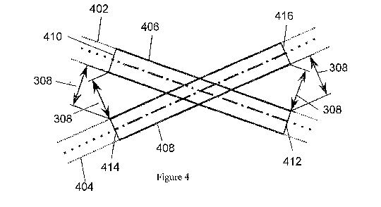
separation greater than a predetermined horizontal distance.
[0051] Figure 4 is a schematic diagram of two crossing flight routes and the
corresponding conflict
paths.
[0052] Figure 5 is a schematic diagram of the trajectories of a hazarding pair
of aircraft along a pair
of flight routes and their corresponding conflict paths.
[0053] Figure 6 is a schematic diagram of a hazarding pair of aircraft which
occupy their
corresponding hazarding conflict paths at different times.
[0054] Figure 7 is a schematic diagram of a hazarding pair of aircraft flying
in opposing directions
which occupy their corresponding hazarding conflict paths at common times.
[0055] Figure 8 is a schematic diagram of determining time separation for a
hazarding pair of aircraft
flying in opposing directions along their corresponding hazarding conflict
paths.
[0056] Figure 9 is a schematic diagram of determining time separation for a
hazarding pair of aircraft
flying in corresponding directions along their corresponding conflict paths,
where the slower aircraft
enters the corresponding conflict path before the faster aircraft.
[0057] Figure 10 is a schematic diagram of determining vertical separation for
an example hazarding
pair of aircraft for which the separation requirement is satisfied.
[0058] Figure 11 is a schematic diagram of determining vertical separation for
an example hazarding
pair of aircraft for which there is loss of vertical separation.
[0059] Figure 12 is a schematic diagram of a first aircraft climbing along a
predicted trajectory and a
second aircraft climbing along a different predicted trajectory.
8
CA 02990332 2017-12-20
WO 2017/013387
PCT/GB2016/051965
[0060] Figure 13 is a schematic diagram of a first aircraft descending along a
predicted trajectory and
a second aircraft descending along a different predicted trajectory.
[0061] Figure 14 is a schematic diagram of a first aircraft climbing along a
predicted trajectory and a
second aircraft descending along a different predicted trajectory.
[0062] Figure 15 is a schematic diagram indicating the time and vertical
separation for a pair of
hazarding aircraft.
[0063] Figure 16 is a schematic diagram of a graphical representation of the
time separation fora
plurality of aircraft pairs.
[0064] Figure 17 is a schematic diagram of updating the graphical
representation of the time
separation to reflect changes in time separation overtime.
[0065] Figure 18 is a flow diagram illustrating a method of detecting
conflicts between aircraft.
[0066] Figure 19 is a flow diagram illustrating a method of detecting
conflicts using portions of aircraft
trajectories corresponding to conflict paths.
[0067] Figure 20 is a flow diagram illustrating a method of determining
conflict paths for pairs of flight
routes.
[0068] Figure 21 is a schematic diagram of an example of an air traffic
control system.
[0069] Figures 22 to 25 are vector diagrams of velocities for an aircraft.
[0070] Figure 26 is a schematic diagram of an interaction display.
[0071] Figure 27 is a schematic diagram of different symbols used on the
interaction display
[0072] Figure 28 is a schematic diagram of two parallel flight routes and the
corresponding conflict
paths.
[0073] Figure 29 is a schematic diagram of a turning flight route and a flight
route inside the turn and
the corresponding conflict paths.
[0074] An air traffic control system is responsible for assuring the safe and
expeditious movement of
air traffic through its airspace and contiguous areas, by assuring that all
aircraft are separated from
each other at all times. An automated conflict detection method and system may
be provided for
identifying conflicts between aircraft for which loss of separation is
predicted to occur. A human air
traffic controller can use the information provided by the conflict detection
to determine how to resolve
the conflicts. Hence, it will be appreciated that the conflict detection
method discussed below need
not include any steps for resolving identified conflicts ¨ this may be the
responsibility of the air traffic
controller. The conflict detection method may merely identify which pairs of
aircraft conflict and/or
provide information concerning the separation of that pair of aircraft, to
enable the air traffic controller
to decide how to deal with the conflict (e.g. by rerouting an aircraft, or
instructing one or both of the
aircraft to change time, route, heading, altitude or speed).
[0075] Alternatively, the conflict detection method can be used in an
automated air traffic control
conflict resolution system which can not only identify the conflicts which may
arise, but also determine
how to resolve the identified conflicts and instruct one or more aircraft to
change time, route, heading,
altitude or speed, without requiring the input of a human air traffic
controller (although a human
controller may still be able to intervene if required).
9
CA 02990332 2017-12-20
WO 2017/013387
PCT/GB2016/051965
[0076] An aircraft intending to fly through controlled airspace is required to
file a flight plan. The flight
plan includes the route that the aircraft intends to fly, referred to as the
flight route. Figure 1 illustrates
an example of a flight route 100. Flight route 100 may be a series of one or
more zero-width routes.
A route is referred to as being zero-width when the flight route has a
negligible width. The start point
102 of flight route 100 is a point with a known latitude and longitude. The
start point 102 may
represent a point, such as the departure point for the route, the entry point
of the route into controlled
airspace or a sector within the controlled airspace. The end point 104 of
flight route 100 is another
point with a known latitude and longitude. The end point 104 may represent a
point, such as an
arrival point for the route, the exit point of the route out of controlled
airspace or a sector within the
controlled airspace. One or more waypoints 106-1, 106-2, 106-3 may be added to
the flight route 100
to further define the horizontal routing of the route. Horizontal within the
scope of the application is
defined within the plane of latitude and longitude - it will be appreciated
that the plane of latitude and
longitude is still considered to be "horizontal" even when taking into account
the curvature of the
earth. Waypoints 106-1, 106-2, 106-3 may be defined by airways, named points
or navigation
beacons. Waypoints 106-1, 106-2, 106-3 may also be points at a prescribed
latitude and longitude.
Although Figure 1 illustrates a flight route 100 with three waypoints 106-1,
106-2, 106-3, the number
of waypoints fora given flight route 100 may be significantly more depending
of the length of the flight
route 100. Alternatively, the flight route 100 may contain no waypoints and
only be defined a start
point 102 and an end point 104.
[0077] Figure 2 illustrates another example of a flight route 200 (a flight
route of the type shown in
Figure 2 may also be referred to as a flight path). Flight route 200 may be a
series of one or more
corridors in the horizontal plane around the nominal flight route 100. Flight
route 200 may be a
sphere-swept volume around the nominal flight route 100. Flight route 200
represents the region
within which an aircraft is expected to be positioned during its flight. The
width 202 of flight route 200
either side of the nominal flight route 100 may be defined by the navigation
tolerances set out the
operational performance specifications, such as Eurocae ED-75C / MASPS
"Required Navigational
Performance for Area Navigation" and equivalents thereof. The width 202 of
flight route 200 may be
defined by the navigational performance of the aircraft. The width 202 of
flight route 200 may be
defined by the navigational requirements of the route. The width 202 of flight
route 200 may vary
along the flight route 200.
[0078] From this point forth corridor flight paths 200 are considered and
depicted. This is not
intended to be in anyway limiting and other embodiments may perform conflict
detection using zero-
width flight routes 100.
[0079] Flight route 200 defines the horizontal routing of a flight, accounting
for the latitudinal and
longitudinal position of the aircraft without accounting for altitude or time.
An aircraft flying along a
flight route will have a predicted trajectory. A predicted trajectory is a
time ordered sequence of when
and where the aircraft will be during a flight. The predicted trajectory
comprises the predicted
horizontal position, predicted altitude and predicted timings for each
position during the aircraft's flight.
The predicted trajectories of pending flights, such as those for aircraft
which have not taken off, cover
CA 02990332 2017-12-20
WO 2017/013387
PCT/GB2016/051965
the whole of the aircraft's flight along a flight route. The predicted
horizontal positions in the predicted
trajectory of a pending flight may correspond to a flight route.
[0080] Multiple aircraft may file a flight plan using the same flight route
200, for example for flights
between the same origin and destination airports with different departure
times or for the same flight
route flown in the opposite direction. As such, the timings of the predicted
trajectories for each aircraft
flying a given flight route may be different. Aircraft flying the same flight
route may be of a different
type or configuration resulting in different cruise and climb performance. As
such, the predicted
altitudes and predicted timings for each aircraft flying a given flight route
may be different. The
predicted trajectories for each aircraft flying a given flight route 200 may
therefore be different.
[0081] When the horizontal separation between two or more flight routes is
below a predetermined
horizontal distance then a conflict may occur between aircraft flying
according to those flight routes. A
conflict path can be defined as a portion of a flight route which has a
horizontal separation from
another flight route less than a predetermined horizontal distance.
[0082] Conflict detection may involve identifying flight routes for a
plurality of aircraft. Based on the
identified flight routes, conflict detection may then involve identifying one
or more conflict paths, which
are regions of the flight routes separated from other flight routes by less
than a given horizontal
distance. Conflict paths may be identified independent of the predicted
trajectories of the aircraft.
[0083] Figure 3 illustrates two flight routes 302, 304 which have a minimum
horizontal separation 306
greater than a predetermined horizontal distance 308. The minimum horizontal
distance 306 is
defined as the smallest distance between the flight routes regardless of
whether a zero-width flight
route 100 or corridor flight route 200 is considered. The predetermined
horizontal distance 308 may
take into account whether a zero-width flight route 100 or corridor flight
route 200 is being considered.
For example, the predetermined horizontal distance between two zero-width
flight routes 100 may be
longer than the predetermined horizontal distance 308 between two corridor
flight routes 200. The
predetermined horizontal distance between two zero-width flight routes 100 may
also be equal to the
predetermined horizontal distance 308 between two corridor flight routes 200
plus the width 202 of
each corridor flight route 200.
[0084] In this example, as the minimum horizontal separation 306 is greater
than the predetermined
horizontal distance 308, and so no conflict paths exist for the flight routes
302, 304. Therefore,
separation of aircraft flying according to the flight routes 302, 304 can be
assured, regardless of the
actual timings and altitudes at which the aircraft are expected to be on the
flight routes, since nowhere
at any part of the flight routes would the aircraft lose horizontal separation
whilst flying within their
required navigational limits. Conflict path identification therefore allows
separation assurance to be
determined independent of the predicted trajectories of the aircraft, thus
without considering altitude
or flight timings of an aircraft. This allows pairs of aircraft flying along
flight routes 302, 304 to be
eliminated from trajectory analysis altogether, reducing the number of pairs
of aircraft that need to be
considered.
[0085] Figure 4 illustrates two crossing flight routes 402, 404. As the
minimum horizontal distance
between the two flight routes 402, 404 is less than the predetermined
horizontal distance 308, a
conflict path for each flight route exists. Conflict path 406 corresponds to
flight route 402 and conflict
11
CA 02990332 2017-12-20
WO 2017/013387
PCT/GB2016/051965
path 408 corresponds to flight route 404. The first end 410 of conflict path
406 corresponds to the
first point along flight route 402 where the horizontal separation is less
than the predetermined
horizontal distance 308. The second end 412 of conflict path 406 corresponds
to the last point along
the flight route 402 where the horizontal separation is less than the
predetermined horizontal distance
308. Similarly, the first end 414 of conflict path 408 corresponds to the
first point along flight route
404 where the horizontal separation is less than the predetermined horizontal
distance 308 and the
second end 416 of conflict path 408 corresponds to the last point along the
flight route 404 where the
horizontal separation is less than the predetermined horizontal distance 308.
The conflict paths 406,
408 may just be defined by a start point 410, 414 and an end point 412, 416
without any width. Flight
routes may have multiple conflict paths along their length corresponding to
different conflicting flight
routes.
[0086] Figure 28 illustrates two parallel flight routes 2802, 2804. As the
minimum horizontal distance
between the two flight routes is less than the predetermined horizontal
distance 308 a conflict path for
each flight route exists, Conflict path 2806 corresponds to flight route 2802
and conflict path 2808
corresponds to flight route 2804. The first end 2810 of conflict path 2806
corresponds to the first point
along flight route 2802 where the horizontal separation is less than the
predetermined horizontal
distance 308. The second end 2812 of conflict path 2806 corresponds to the
last point along the flight
route 2802 where the horizontal separation is less than the predetermined
horizontal distance 308.
Similarly, the first end 2814 of conflict path 2808 corresponds to the first
point along flight route 2804
where the horizontal separation is less than the predetermined horizontal
distance 308 and the
second end 2816 of conflict path 2808 corresponds to the last point along the
flight route 2804 where
the horizontal separation is less than the predetermined horizontal distance
308. The conflict paths
2806, 2808 may just be defined by a start point 2810, 2814 and an end point
2812, 2816 without any
width.
[0087] Figure 29 illustrates a flight route 2902 that has a fly-by turn 2920
at waypoint 2918 and a
flight route 2904 that starts inside the fly-by turn of route 2902. As the
minimum horizontal distance
between the between the two flight routes is less than the predetermined
horizontal distance 308 a
conflict path for each flight route exists. Conflict path 2906 corresponds to
flight route 2902 and
conflict path 2908 corresponds to flight route 2904. The first end 2910 of
conflict path 2906
corresponds to the first point along flight route 2902 where the horizontal
separation is less than the
predetermined horizontal distance 308. The second end 2912 of conflict path
2906 corresponds to the
last point along the flight route 2902 where the horizontal separation is less
than the predetermined
horizontal distance 308. Similarly, the first end 2914 of conflict path 2908
corresponds to the first point
along flight route 2904 where the horizontal separation is less than the
predetermined horizontal
distance 308 and the second end 2916 of conflict path 2908 corresponds to the
last point along the
flight route 2904 where the horizontal separation is less than the
predetermined horizontal distance
308 from the fly-by turn tolerance 2922 of flight route 2902. The conflict
paths 2906, 2908 may just be
defined by a start point 2910, 2914 and an end point 2912, 2916 without any
width.
[0088] Similarly, if in the example of Figure 3 the minimum horizontal
separation 306 had been
smaller than the predetermined horizontal distance 308 then conflict paths
would be identified
12
CA 02990332 2017-12-20
WO 2017/013387
PCT/GB2016/051965
corresponding to portions of the flight routes 302, 304 where the horizontal
separation 306 is smaller
than the predetermined horizontal distance 308.
[0089] The direction an aircraft will fly along a given flight route is not
important to the determination
of conflict paths (the identification of the conflict paths considers only the
horizontal positions of the
flight routes and not the aircraft heading, predicted timings, speeds etc. of
specific aircraft flying along
the routes as represented by the aircraft predicted trajectories). For
example, Figure 5 shows aircraft
502 approaching conflict path 406 wherein aircraft 502 will enter conflict
path 406 at second end 412
and aircraft 502 will exit conflict path 406 at first end 410. Aircraft 504
has already travelled through
conflict path 408. Having entered conflict path 408 at first end 414, aircraft
504 exited conflict path
408 at end 416.
[0090] Conflict detection may be performed using portions of the predicted
trajectories of a plurality
of aircraft corresponding to positions within one or more conflict paths.
Portions of the predicted
trajectories corresponding to positions outside conflict paths can be
determined as satisfying the
separation requirement (their separation can be assured) and therefore may be
eliminated from
subsequent conflict detection.
[0091] For a given pair of aircraft, if their corresponding flight routes have
conflict paths separated by
a horizontal separation less than the predetermined horizontal distance, then
they are referred to as a
hazarding pair of aircraft. Their corresponding conflict paths are referred to
as hazarding conflict
paths. Conflict detection may involve identifying at least one hazarding pair
of aircraft for which the
flight routes for that hazarding pair of aircraft have hazarding conflict
paths separated by a horizontal
separation less than a predetermined horizontal distance.
[0092] For a given hazarding pair of aircraft, it may be determined that a
separation requirement is
satisfied between the aircraft once one of the hazarding pair of aircraft has
travelled beyond a
corresponding one of the hazarding conflict paths. As illustrated in Figure 5,
hazarding pair of aircraft
502, 504 have corresponding conflict paths 406, 408. Aircraft 504 has already
travelled beyond its
corresponding conflict path 408, therefore it can be determined that a
separation requirement is
satisfied between hazarding pair of aircraft 502, 504. If it has been
determined that a separation
requirement is satisfied between the aircraft 502, 504 due to one of the
hazarding pair of aircraft 504
having travelled beyond a corresponding hazarding conflict path 408, the given
hazarding pair of
aircraft 502, 504 may be eliminated from subsequent conflict detection so it
is not necessary to
consider the time-dependent trajectories of the hazarding pair of aircraft
502, 504 further.
[0093] At least part of the identifying conflict paths and at least part of
the conflict detection may be
repeated in response to identifying a new flight (e.g. a new aircraft to be
considered) or an update to a
flight route for an existing aircraft. A flight route may be updated to add or
remove waypoints from the
routing or to alter the routing for conflict avoidance.
[0094] The predicted trajectories for each aircraft may also change during the
flight. Events that
cause a trajectory update may include: receipt of surveillance data, a change
in aircraft flight state, a
change in meteorological forecast data or receipt of a new trajectory from the
aircraft. Surveillance
data may be received from radar systems, Automatic Dependent Surveillance-
Broadcast (ADS-B)
systems or other surveillance systems. An aircraft state may change at
different portions of a flight,
13
CA 02990332 2017-12-20
WO 2017/013387
PCT/GB2016/051965
for example a flight being given push-back or taxi clearance at an airport, a
flight taking off from an
airport or a signal from an external Flight Information Region (FIR) that a
flight is approaching an FIR
boundary. Meteorological forecast data, such as wind and temperature, is
updated periodically, for
example every 6 hours. An aircraft may create its own predicted trajectory and
send it to the ATC
system for incorporation into the conflict detection method. Hence, at least
part of the conflict
detection may be repeated in response to an update to the predicted trajectory
of an aircraft.
[0095] For a hazarding pair of aircraft for which neither aircraft has yet
flown past its corresponding
hazarding conflict path, the conflict detection may consider one or both of
the predicted altitudes
(vertical positions) and timings at which the aircraft are expected to occupy
the conflict paths. A
conflict is determined when there is simultaneous loss of horizontal
separation, vertical separation
and time separation. The identification of the hazarding conflict paths
indicates a potential loss of
horizontal separation. Hence, by performing checks to determine whether there
is loss of time
separation and/or vertical separation when the aircraft are within the
conflict paths, the risk of conflict
can be identified.
[0096] Figure 15 illustrates the time and altitude separation for a hazarding
pair of aircraft 1502,
1504. Overall separation of a hazarding pair of aircraft 1502, 1504 may be
assured if the hazarding
pair of aircraft 1502, 1504 are not predicted to occupy their corresponding
conflict paths at the same
time or if the hazarding pair of aircraft are vertically separated at
positions corresponding to their
hazarding conflict paths. For example, if the separation time 1506 between the
time windows when
the respective aircraft are expected to be within their conflict paths is
greater than a given threshold,
then separation can be assured. Similarly, if the separation altitude 1508
between the altitude ranges
at which the aircraft are expected to reside within the conflict paths is
greater than a given threshold,
then separation can be assured. To lose overall separation, the separation
time 1506 of a hazarding
pair of aircraft 1502, 1504 must be less than the first predetermined time
threshold and the vertical
separation 1508 of the hazarding pair of aircraft 1502, 1504 must be less than
the predetermined
vertical distance simultaneously. Hence, if the windows within which the pair
of aircraft are predicted
to be within their conflict paths are separated in time and/or altitude,
separation can be assured
without comparing the trajectories of the aircraft in more detail.
[0097] On the other hand, if the time and altitude windows within which the
hazarding pair of aircraft
are expected to occupy the conflict paths are not separated in time and
altitude, then further checking
of the trajectories can be performed as discussed below. The checking of the
time separation and the
vertical separation could be performed in either order. The time separation
analysis is described first
below, but it will be appreciated that in other embodiments the vertical
separation could be considered
before the time separation. Either way, if analysis of one of the time
separation or vertical separation
indicates that there is no loss of separation, then it is not necessary to
continue to analyse the other of
the time separation or the vertical separation. In some cases, if the vertical
separation determination
requires a comparison of the predicted altitudes at a series of time points,
it may be simpler to do the
time separation determination first.
[0098] Figures 6 to 9 show examples of determining time separation between a
hazarding pair of
aircraft. The time separation may be an indication of a change in timing of
one of the aircraft that
14
CA 02990332 2017-12-20
WO 2017/013387
PCT/GB2016/051965
would cause the hazarding pair of aircraft to lose separation (if the aircraft
are currently predicted to
meet the separation requirement) or regain separation (if the aircraft are
currently predicted to lose
separation). The time separation between a given hazarding pair of aircraft
may depend on the
direction the aircraft are flying relative to each other. Aircraft may be
defined as flying in opposing
directions when the relative angle between the relative direction of the
aircraft through their conflict
paths is greater than or equal to 900 and aircraft may be defined as flying in
corresponding directions
when the relative angle between the relative direction of the aircraft through
their conflict paths is less
than 90 .
[0099] Figure 6 illustrates a hazarding pair of aircraft 602, 604 and their
corresponding conflict paths
606, 612, in a case where the aircraft 602, 604 are approaching in opposing
directions. The first
aircraft 602 enters its corresponding conflict path 606 at time 608 and exits
its corresponding conflict
path 606 at time 610. The second aircraft 604 enters its corresponding
conflict path 612 at time 614
and exits its corresponding conflict path 612 at time 616. The timings at
which each of the hazarding
pair of aircraft 602, 604 are expected to occupy their corresponding conflict
paths 606, 612 can be
compared to determine whether the hazarding part of aircraft 602, 604 are
expected to occupy their
corresponding conflict paths 606, 612 simultaneously. For example, if time 610
occurs before time
614, then the first aircraft 602 does not occupy its conflict path 606 at the
same time as the second
aircraft 604 occupies its conflict path 612, and it can be determined that the
separation requirement is
satisfied and separation is therefore assured. In the example in Figure 6,
time 610 occurs before time
614 as illustrated in time plot 600 and therefore separation of the aircraft
602, 604 can be assured as
the aircraft 602, 604 cannot occupy their corresponding conflict paths 606,
612 at the same time.
[0100] A common period may be defined as the time when both aircraft in a
given hazarding pair of
aircraft are predicted to occupy their corresponding hazarding conflict paths
simultaneously. The start
of the common period may be defined as the earliest time that the second
aircraft is predicted to enter
its conflict path. The end of the common period the latest time that the first
aircraft is predicted to exit
its conflict path. The duration of the common period may then be defined as
the difference between
the start time and end time of the common period. If the duration is positive,
this indicates the length
of the period that both aircraft in a given hazarding pair of aircraft are
predicted to occupy their
corresponding hazarding conflict paths simultaneously (see common period 718
in Figure 7). If the
duration is negative, this indicates the amount of separation between the
timings at which the aircraft
occupy their conflict paths (see common period 618 in Figure 6). In both
cases, the time separation
may be determined as the negation of the common period duration.
[0101] The along track separation of a hazarding pair of aircraft 802, 804
will be at a minimum at the
time 806 when aircraft 802 and aircraft 804 pass each other (see Figure 8).
The time 806 when
aircraft 802 and aircraft 804 are predicted to pass can also be determined
using the conflict paths.
Also, the times when the aircraft 802, 804 are predicted to lose and regain
separation can be
determined, which may depend upon the time 806 when aircraft 802, 804 are
predicted to pass each
other and the time taken for the aircraft 802, 804 to cover the along track
separation distance (i.e. the
time is dependent on the relative speed of aircraft 802, 804). Examples of
determining these timings
are given below.
CA 02990332 2017-12-20
WO 2017/013387
PCT/GB2016/051965
[0102] In the example illustrated in Figure 9, aircraft 902 and aircraft 904
are flying in corresponding
directions (in-trail). In this example, determining whether aircraft 902, 904
may lose separation
depends upon the relative speed of aircraft 902, 904. If the first aircraft
902 to enter its corresponding
conflict path 906 is flying faster than, or at the same speed as, the trailing
aircraft 904 then the
separation of aircraft 902, 904 can be assured if they are separated when they
enter their
corresponding conflict paths 906, 908. In this case, the time separation of
aircraft 902, 904 may be
determined based on the difference in the times that the aircraft 902, 904 are
predicted to enter their
corresponding conflict paths 906, 908. If the first aircraft 902 to enter its
corresponding conflict path
906 is flying slower than the trailing aircraft 904 and the first aircraft 902
is predicted to exit its
corresponding conflict path 906 before the trailing aircraft 904 is predicted
to exit its corresponding
conflict path 908 then the time separation may be determined based on the
difference in the times
that the aircraft 902, 904 are predicted to exit their corresponding conflict
paths 906, 908. Examples
of these calculations are given below.
[0103] In the example illustrated in figure 9, aircraft 904 is predicted to
enter 914 its corresponding
conflict path 908 after aircraft 902 is predicted to enter 910 its
corresponding conflict path 906 and
aircraft 904 is predicted to exit 916 its corresponding conflict path 908
before aircraft 902 is predicted
to exit 912 its corresponding conflict path 906. As such, aircraft 904 will
pass 918 aircraft 902 whilst
both aircraft are in their corresponding conflict paths. In this example, the
time separation may be the
smaller of time separations determined by the entry 910, 914 and exit 912, 916
times of the aircraft.
[0104] For aircraft flying in-trail, the times when the aircraft 902, 904 are
predicted to lose and regain
separation may depend on the relative speed of the aircraft 902, 904 and their
separation distance
when the aircraft 902, 904 enter their corresponding conflict paths 906, 908.
[0105] To lose horizontal separation, a hazarding pair of aircraft must lose
both along-track and
across-track separation simultaneously. For example, the hazarding pair of
aircraft must lose along-
track separation during the common period whilst both aircraft in the
hazarding pair of aircraft are
flying through their corresponding conflict paths.
[0106] It may be determined that the separation requirement is satisfied
between a given hazarding
pair of aircraft when the time separation is greater than a first
predetermined time threshold. If it has
been determined that the separation requirement is satisfied between a
hazarding pair of aircraft due
to the time separation being greater than a first predetermined time
threshold, the given hazarding
pair of aircraft may be eliminated from subsequent conflict detection. The
first predetermined time
threshold may be zero. The first predetermined time threshold may be greater
than zero, for example
1 minute or longer, to account for uncertainty in the predicted timings of the
aircraft.
[0107] A time period during which separation cannot be assured may be
determined at the timings
between the first time that the horizontal separation between the predicted
trajectories of a hazarding
pair of aircraft is less than the predetermined horizontal distance and the
last time that the horizontal
separation between the predicted trajectories of a hazarding pair of aircraft
is less than the
predetermined horizontal distance. This time period may also be used to
determine the earliest time
that separation between a hazarding pair of aircraft may be lost or no longer
assured.
16
CA 02990332 2017-12-20
WO 2017/013387
PCT/GB2016/051965
[0108] Figures 10 and 11 show examples of determining whether there is loss of
vertical separation.
The vertical separation of a hazarding pair of aircraft may be determined
based on the predicted
altitude of each aircraft in the hazarding pair of aircraft at positions
corresponding to their respective
hazarding conflict paths. The predicted altitude of each aircraft may
represent a prescribed clearance
level that the aircraft has been requested to maintain or be based on the
altitudes defined in the
trajectory for the aircraft.
[0109] The vertical separation of the hazarding pair of aircraft may be
determined based on a range
of altitudes that each aircraft in the hazarding pair of aircraft can occupy
whilst positioned inside their
respective hazarding conflict paths.
[0110] Figure 10 illustrates the ranges of altitudes for each aircraft in an
example hazarding pair of
aircraft whilst positioned inside their respective hazarding conflict paths.
The first aircraft has a
maximum altitude 1002 and minimum altitude 1004 whilst positioned inside its
conflict path and the
second aircraft has a maximum altitude 1006 and a minimum altitude 1008 whilst
inside its conflict
path. The vertical separation between the hazarding pair of aircraft may be
determined based upon
the altitudes that the hazarding pair of aircraft occupy at the same time
whilst both aircraft are situated
within their respective hazarding conflict paths.
[0111] It may be determined that the separation requirement is satisfied and
that separation is
assured between a given hazarding pair of aircraft when the vertical
separation is greater than a
predetermined vertical distance at each time that both aircraft in the
hazarding pair of aircraft occupy
their respective conflict paths. If it has been determined that the separation
is assured between a
hazarding pair of aircraft due to the vertical separation being greater than a
predetermined vertical
distance, the given hazarding pair of aircraft may be eliminated from
subsequent conflict detection.
For example the predetermined vertical distance may be 1000 feet. The
predetermined vertical
distance may be greater than 1000 feet, for example 2000 feet or more, to
account for uncertainty in
the predicted altitudes of the aircraft.
[0112] In the example illustrated in Figure 10, the vertical separation 1010
between the predicted
altitudes of the first aircraft and the second aircraft at each time that both
aircraft in the hazarding pair
of aircraft occupy their respective conflict paths is greater than the
predetermined vertical distance
1012 and therefore it may be determined that separation is assured between the
two aircraft. Figure
11 illustrates a different example of the ranges of altitudes for each
aircraft in an example hazarding
pair of aircraft whilst positioned inside their respective hazarding conflict
paths. The vertical
separation 1110 between the first aircraft and the second aircraft at a given
time is less than the
predetermined vertical distance 1112 and therefore separation between the two
aircraft cannot be
assured.
[0113] The vertical separation of a hazarding pair of aircraft may be
determined for any flight phase
of an aircraft which has a position corresponding to the hazarding conflict
paths. For example, one
aircraft in the hazarding pair of aircraft may be in level flight whilst the
other is descending, both
aircraft in the hazarding pair of aircraft may be climbing or one aircraft in
the hazarding pair of aircraft
may be descending whilst the other is climbing and other combinations thereof.
The vertical
17
CA 02990332 2017-12-20
WO 2017/013387
PCT/GB2016/051965
separation of a hazarding pair of aircraft may be determined in the same way
regardless of the
direction of travel of each aircraft in the hazarding aircraft pair.
[0114] For a hazarding pair of aircraft which are in level flight or where
both aircraft are climbing and
descending simultaneously, if the vertical separation when the aircraft enter
their corresponding
hazarding conflict paths is greater than the predetermined vertical distance,
vertical separation may
be assured if the vertical separation between each point in time along their
predicted trajectories
corresponding to a hazarding conflict path is greater than the predetermined
vertical distance.
[0115] Figure 12 illustrates an example where a first aircraft 1202 is
climbing along a predicted
trajectory 1204 and a second aircraft 1206 is climbing along a predicted
trajectory 1208. Aircraft 1206
is above aircraft 1202 and the separation 1210 between the higher aircraft
1206 and the lower aircraft
1202 is initially greater than the predetermined vertical distance 1216. The
separation 1210 between
the lowest predicted trajectory 1212 of the higher aircraft 1206 and the
highest predicted trajectory
1214 of the lower aircraft 1202 is greater than the predetermined vertical
distance 1216 at each point
along the predicted trajectories of the aircraft. As such, it may be
determined that vertical separation
is assured between the two aircraft and separation may be assured.
[0116] Figure 13 illustrates an example where a first aircraft 1302 is
descending along a predicted
trajectory 1304 and a second aircraft 1306 is descending along a predicted
trajectory 1308. Aircraft
1306 is above aircraft 1302 and the separation 1310 between the higher
aircraft 1306 and the lower
aircraft 1302 is initially greater than the predetermined vertical distance
1316. The separation 1310
between the lowest predicted trajectory 1312 of the higher aircraft 1306 and
the highest predicted
trajectory 1314 of the lower aircraft 1302 is greater than the predetermined
vertical distance 1316 at
each point along the predicted trajectories of the aircraft. As such, it may
be determined that vertical
separation is assured between the two aircraft and separation may be assured.
[0117] Figure 14 illustrates an example where a first aircraft 1402 is
climbing along a predicted
trajectory 1404 and a second aircraft 1406 is descending along a predicted
trajectory 1408. The
vertical separation at positions along the predicted trajectories 1404, 1408
of the aircraft 1402, 1406
fall below the predetermined vertical distance 1416. As such, separation
between the two aircraft
cannot be assured. A period during which separation cannot be assured may be
determined at the
timings between the first time that the vertical separation between the
predicted altitudes of a
hazarding pair of aircraft is less than the predetermined vertical distance
1416 and the last time that
the vertical separation between the predicted altitudes of a hazarding pair of
aircraft is less than the
predetermined vertical distance 1416.
[0118] A warning indication may be outputted if for a given hazarding pair of
aircraft when the time
separation is less than a second predetermined time threshold. The warning may
be audible or
visual, or a combination thereof. For example a symbol may be displayed or
flashed on a display
screen, accompanied by an audible alarm sounding. The second predetermined
time threshold may
be less than the first predetermined time threshold, for example the second
predetermined time
threshold could be zero and the first predetermined time threshold could be 1
minute. Alternatively,
the first and second predetermined time thresholds could be the same.
18
CA 02990332 2017-12-20
WO 2017/013387
PCT/GB2016/051965
[0119] An indication of the time separation determined for at least one
hazarding pair of aircraft may
be displayed. The indication may be text, a picture or combinations thereof.
[0120] A graphical representation of the time separation for one or more
hazarding pairs of aircraft
may be displayed. For example a symbol representing the hazarding pair of
aircraft may be displayed
on a display screen. The symbol representing the hazarding pair of aircraft
may also contain
additional information about the hazarding pair of aircraft, for example the
callsigns of each aircraft in
the hazarding pair of aircraft. The symbol representing the hazarding pair of
aircraft may also give an
indication of the direction the aircraft in the hazarding pair of aircraft are
flying relative to each other.
For example, a first symbol may be used if the aircraft are travelling in
opposing directions and a
second symbol may be used if the aircraft are travelling in corresponding
directions. The symbol may
also give an indication of which aircraft in the hazarding pair of aircraft is
travelling faster, or which
aircraft in the hazarding pair of aircraft is predicted to enter a hazarding
conflict path first. For
example, a third symbol may be used to indicate an aircraft that is travelling
faster, or the callsigns for
the hazarding pair of aircraft may be listed in order of aircraft speed.
Alternatively, the callsigns for
the hazarding pair of aircraft may be listed in order of the position of the
aircraft, for example the
callsign for the aircraft predicted to enter a hazarding conflict path first,
or the lead aircraft, may be
displayed above or to the left of the callsign for the trailing aircraft. The
callsign of the faster aircraft or
the aircraft predicted to enter a conflict path first may also be displayed
differently to the callsign of the
slower aircraft or trailing aircraft, for example in a different font, style
or colour.
[0121] The graphical representation of the time separation may comprise a
graph in which one or
more points representing at least one hazarding pair of aircraft are plotted.
Figure 16 illustrates an
example of a graphical representation 1600 of the time separation for a
plurality of aircraft pairs.
Each symbol 1602, 1604, 1606, 1608 represents a pair of hazarding aircraft.
The callsigns 1610,
1612 of each aircraft in the hazarding pair of aircraft are displayed next to
the corresponding symbol
1602. The top callsign 1610 may represent the lead aircraft or the aircraft
which is travelling faster.
[0122] The x axis 1614 represents the time to conflict for a given pair of
aircraft. The time to conflict
may be in minutes or hours and gives an indication of the time remaining until
a given pair of aircraft
reach their minimum time separation. For example, the x axis 1614 may
represent an expected
timing at which one or the hazarding pair of aircraft is expected to be at a
corresponding one of the
hazarding conflict paths. The time at which a given pair of aircraft conflict
may be represented by the
y axis intercept or by another point on the x axis 1614. The y axis 1616
represents the time
separation for each of the hazarding pair of aircraft. A time separation of
zero may be represented by
the x axis intercept or by another point on they axis 1616. An alternative set
of axes may be used to
provide a graphical representation of the time separation. Additionally, the
time separation may be
represented on the x axis 1614.
[0123] The first horizontal line 1618 represents the first predetermined time
threshold. Symbols
1602, 1604 located above the first horizontal line 1618 represent a hazarding
pair of aircraft which
have a time separation greater than the first predetermined time threshold.
Symbols 1606, 1608
located below the first horizontal line 1618 represent a hazarding pair of
aircraft which have a time
separation less than the first predetermined time threshold. The symbols 1602,
1604 located above
19
CA 02990332 2017-12-20
WO 2017/013387
PCT/GB2016/051965
the first horizontal line 1618 may be a different type, size and colour to the
symbols 1606, 1608
located below the first horizontal line 1618.
[0124] The second horizontal line 1620 represents the second predetermined
time threshold.
Symbols 1608 located below the second horizontal line 1620 represent a
hazarding pair of aircraft
which have a time separation less than the second predetermined time
threshold, i.e. pairs of aircraft
for which the warning of loss of separation may be issued (if vertical
separation is also not assured).
Symbols 1608 located below the second horizontal line 1620 may be a different
type, size and colour
to the other symbols 1602, 1604, 1606. In addition, symbols 1608 located below
the second
horizontal line 1620 may flash on the screen, change colour periodically, have
an audible tone
associated with them or other means to make the symbols 1608 more prominent
than other symbols
located on the graph. Symbols 1606 located between the first horizontal line
1618 and the second
horizontal line 1620 represent a hazarding pair of aircraft which have a time
separation greater than
the second predetermined time threshold but less than the first predetermined
time threshold.
Symbols 1606 located between the first horizontal line 1618 and the second
horizontal line 1620 may
be a different type, size and colour to the symbols located above the first
horizontal line or below the
second horizontal line.
[0125] The determination of the time separation for at least one hazarding
pair of aircraft is repeated
and the display is updated to reflect changes in the time separation overtime.
The determination of
time separation is repeated each time part of the conflict detection is
performed, for example in
response to the identification of a new or updated flight route or an update
to the predicted trajectory
of an aircraft. Figure 17 illustrates an example of a graphical representation
1700 of the time
separation for a plurality of aircraft pairs. The symbols 1602, 1604 are the
same as those indicated in
Figure 16.
[0126] Arrow 1702 indicates the movement of symbol 1608 overtime. Symbol 1608
starts at an
initial position 1608-1. As the changes in time separation over time are
calculated, the time
separation between the aircraft 1704, 1706 represented by symbol 1608
increases. Therefore as
time passes, aircraft 1704 and 1706 get closer to their time to conflict, so
the time to conflict
decreases and symbol 1608 moves left along the x axis 1614. As the time
separation between
aircraft 1704 and 1706 increases overtime, symbol 1608 moves up they axis
1616. Therefore, after
a given period of time, symbol 1608 moves from its initial position 1608-1 to
a second position 1608-2
as indicated by arrow 1702. As symbol 1608-2 is located above the second
horizontal line 1620, but
below the first horizontal line 1618, it will change type, size and/or colour
accordingly as it crosses the
second horizontal line 1620. The movement of the symbol 1608 representing a
given pair of aircraft
towards the top left of the display in a direction similar to arrow 1702
indicates that the likelihood of a
conflict is reducing for this pair of aircraft.
[0127] Arrow 1704 indicates the movement of symbol 1606 overtime. Symbol 1606
starts at an
initial position 1606-1. As the changes in time separation over time are
calculated, the time
separation between the aircraft 1708, 1710 represented by symbol 1606
decreases. Therefore as
time passes, aircraft 1708 and 1710 get closer to their respective hazarding
conflict paths, so the time
to conflict decreases and symbol 1606 moves left along the x axis 1614. As the
time separation
CA 02990332 2017-12-20
WO 2017/013387
PCT/GB2016/051965
between aircraft 1708 and 1710 decreases overtime, symbol 1606 moves down they
axis 1616.
Therefore, after a given period of time, symbol 1606 moves from its initial
position 1606-1 to a second
position 1606-2 as indicated by arrow 1704. As symbol 1606-2 is located below
the second horizontal
line 1620, it will change type, size and/or colour accordingly as it crosses
the second horizontal line
1620. A warning indication may also be outputted at the moment when symbol
1606 crosses the
second horizontal line 1620. The air traffic controller or operator of the
method can easily track and
monitor the movement of symbol 1606 along arrow 1704, allowing them to
identify hazarding pairs of
aircraft which may require corrective action before the symbol 1606 passes
below the second
horizontal line 1620. This allows the controller or operator of the method to
take corrective action
earlier, reducing the risk of conflict and increasing safety. The air traffic
controller or operator can
also track the movement of symbol 1608 along arrow 1702, allowing them to
identify that the time
separation between the aircraft is increasing such that the risk of conflict
is reducing and allowing
them to determine that no corrective action may be required at that time.
[0128] A rate of change of the time separation over time may be determined.
The rate of change of
time separation is a good indication of the way in which a conflict situation
is changing and evolving.
For example, a positive rate of change of the time separation indicates that
the time separation
between a hazarding pair of aircraft is increasing and therefore the risk of
the hazarding pair of aircraft
losing separation is reducing. Conversely, a negative rate of change of the
time separation indicates
that the time separation between a hazarding pair of aircraft is decreasing
and therefore the risk of the
hazarding pair of aircraft losing separation is increasing. The rate of change
of time separation is
expected to be positive for all active flights as the uncertainty over the
position and timings of each
aircraft is decreasing. A negative rate of change of time separation may
therefore indicate an error in
one or more of the predicted trajectories, for example due to poor or
incorrect meteorological forecast
data or aircraft performance data.
[0129] An indication of the rate of change of the time separation may be
displayed. For example, a
numerical indication of the rate of change of separation fora hazarding pair
of aircraft may be
indicated near their corresponding symbol 1602 on graphical representation
1600. The symbol 1602
may change colour to indicate a positive or a negative time separation. The
symbol 1602 may also
flash when the rate of change of time separation for the corresponding
hazarding pair of aircraft is
within a given range, for example when the rate of change of time separation
is less than zero. The
rate at which symbol 1602 flashes may also increase as the magnitude of the
rate of change of time
separation increases. This alerts the air traffic controller or operator of
the method to a hazarding pair
of aircraft which have a rapidly decreasing time separation and thus may
require corrective action.
Also, this also alerts the air traffic controller or operator of the method to
a hazarding pair of aircraft
which may have an error in one or more of their predicted trajectories.
[0130] Figure 18 is a flow diagram illustrating a method of detecting
conflicts between a plurality of
aircraft.
[0131] At step 1802 flight routes are identified for a number of aircraft to
be considered.
[0132] At step 1804 conflict paths are identified. Conflict paths may be
identified by comparing the
horizontal positions of the identified flight routes to determine portions of
a flight route which has a
21
CA 02990332 2017-12-20
WO 2017/013387
PCT/GB2016/051965
horizontal separation from another flight route less than the predetermined
horizontal distance.
Alternatively, conflict paths may be identified by looking up pairs of the
identified flight routes in a
database specifying conflict paths for each pair of flight routes (the
database may be established
using the method of Figure 20 shown below).
[0133] At step 1806 conflict detection is performed using portions of aircraft
trajectories
corresponding to conflict paths.
[0134] At step 1808 it is determined whether a predicted aircraft trajectory
has been updated. A
predicted aircraft trajectory may be updated based on, for example, receipt of
surveillance data, a
change in aircraft flight state, a change in the meteorological forecast data
or receipt of a new
trajectory from the aircraft. If a predicted aircraft trajectory has been
updated, the method returns to
step 1806 to repeat at least part of the conflict detection (but the conflict
path identification step is not
repeated 1804). If a predicted aircraft trajectory has not changed, the method
continues to step 1810.
[0135] At step 1810 it is determined whether a new flight has been created or
a flight route has been
updated. A new flight may be created when an airline wishes to fly between a
new airport pair. A
flight route may be updated to add or remove waypoints from the routing or to
alter the routing for
conflict avoidance. If a new flight has been created or a flight route has
been updated, the method
returns to step 1802. If no new flights have been created and no flight routes
have been updated then
the method ends. The method may start every time a new flight is created or a
flight route is updated.
The method may also be started periodically, for example every 5 seconds or
every minute.
[0136] Figure 19 is a flow diagram illustrating step 1806 in more detail. At
step 1902 the next aircraft
X is selected. Aircraft X has a predicted trajectory along an identified
flight route.
[0137] At step 1904 it is determined whether any conflict paths exist for
aircraft X. If there are no
conflict paths for the flight route corresponding to the predicted trajectory
of aircraft X, then the
method continues to step 1906. At step 1906 it can be determined that a
separation requirement is
satisfied for aircraft X as there are no conflict paths corresponding to the
predicted trajectory for
aircraft X (i.e. no part of aircraft X's flight route is within the
predetermined horizontal distance of the
flight route of another aircraft being considered). Aircraft X can then be
eliminated from subsequent
conflict detection and the method returns to step 1902 where the next aircraft
X is selected.
[0138] If, at step 1904, it is determined that conflict paths do exist for the
flight route corresponding to
the predicted trajectory of aircraft X then the method continues to step 1908.
At step 1908 the next
aircraft Y is selected. Aircraft Y is an aircraft which has a hazarding
conflict path with aircraft X.
Aircraft X and aircraft Y form a hazarding pair of aircraft X,Y.
[0139] At step 1910 it is determined, based on the trajectories of aircraft X,
Y, whether one of aircraft
X or aircraft Y has travelled beyond its hazarding conflict path. If one of
aircraft X or aircraft Y has
travelled beyond the hazarding conflict path then the method continues to step
1930. At step 1930 it
can be determined that the separation requirement is satisfied for hazarding
pair of aircraft X,Y.
Hazarding pair of aircraft X,Y can then be eliminated from subsequent conflict
detection and the
method continues to step 1932. If, at step 1910, it is determined that neither
aircraft X nor aircraft Y
has travelled beyond a hazarding conflict path then the method continues to
step 1911. At step 1911
it is determined, based on the trajectories of aircraft X, Y, whether the
aircraft can occupy their
22
CA 02990332 2017-12-20
WO 2017/013387
PCT/GB2016/051965
hazarding conflict paths at the same time. If the aircraft cannot occupy the
hazarding conflict paths at
the same time then the method continues to step 1930. At step 1930 it can be
determined that the
separation requirement is satisfied for hazarding pair of aircraft X,Y.
Hazarding pair of aircraft X,Y
can then be eliminated from subsequent conflict detection and the method
continues to step 1932. If
at step 1911 it can be determined that the aircraft can occupy their hazarding
conflict paths at the
same time then the method continues to step 1912. At step 1912 the time
separation between the
timings at which the hazarding pair of aircraft X,Y are expected to be at
positions corresponding to the
hazarding conflict paths is determined. The time separation can be an
indication of the amount of
time by which the trajectory timing of one of aircraft X, Y would need to
change in order to lose or
regain separation.
[0140] At step 1914 it is determined whether the time separation between the
timings at which the
hazarding pair of aircraft X,Y are expected to be at positions corresponding
to the hazarding conflict
paths is greater than a first predetermined time threshold. If the time
separation is greater than the
first predetermined time threshold then the method continues to step 1930. At
step 1930 it can be
determined that the separation requirement is satisfied for hazarding pair of
aircraft X,Y. Hazarding
pair of aircraft X,Y can then be eliminated from subsequent conflict detection
and the method
continues to step 1932. If the time separation between the timings at which
the hazarding pair of
aircraft X,Y are expected to be at positions corresponding to the hazarding
conflict paths is less than
a first predetermined time threshold then the method continues to step 1916.
[0141] At step 1916 the vertical separation between the predicted trajectories
of hazarding pair of
aircraft X,Y at positions corresponding to the hazarding conflict paths is
determined.
[0142] At step 1918 it is determined whether the minimum vertical separation
between the predicted
trajectories of hazarding pair of aircraft X,Y is greater than a predetermined
vertical distance. If the
vertical separation between the predicted trajectories of hazarding pair of
aircraft X,Y is greater than a
predetermined vertical distance then the method continues to step 1930. At
step 1930 it can be
determined that the separation requirement is satisfied for hazarding pair of
aircraft X,Y. Hazarding
pair of aircraft X,Y can then be eliminated from subsequent conflict detection
and the method
continues to step 1932. If, at step 1918, it is determined that the vertical
separation between the
predicted trajectories of hazarding pair of aircraft X,Y is less than a
predetermined vertical distance
then the method continues to step 1920. At step 1920 hazarding pair of
aircraft X,Y are displayed,
e.g. on a graph as shown in Figures 16 and 17.
[0143] At step 1922 it is determined whether the time separation between the
timings at which the
hazarding pair of aircraft X,Y are expected to be at positions corresponding
to the hazarding conflict
paths is less than a second predetermined time threshold. If the time
separation is less than the
second predetermined time threshold then the method continues to step 1926. At
step 1926 it is
determined that there is a conflict for hazarding aircraft pair X,Y and a
conflict warning indication is
outputted and the method continues to step 1928. If, at step 1922, the time
separation is greater than
the second predetermined time threshold then the method continues to step
1924. At step 1924 it is
determined that the separation requirement is satisfied for hazarding pair of
aircraft X,Y and the
23
CA 02990332 2017-12-20
WO 2017/013387
PCT/GB2016/051965
method continues to step 1928. At step 1928 the rate of change of time
separation for hazarding
aircraft pair X,Y is determined and the method continues to step 1932.
[0144] At step 1932 it is determined whether any more conflict paths exist for
aircraft X. If additional
conflict paths do exist for aircraft X then the method returns to step 1908
and the next aircraft Y is
selected. If no additional conflict paths exist for aircraft X then the method
returns to step 1902 and
the next aircraft X is selected.
[0145] The method illustrated in Figure 19 is applied for each aircraft X
until the method has been
applied to all aircraft. Once the method has been applied to all aircraft, the
method illustrated in
Figure 18 continues to step 1808. Alternatively, the method illustrated in
Figure 19 may only be
applied to certain aircraft. For example, if at step 1808 a set of aircraft
with changed predicted
trajectories are identified, the method illustrated in Figure 19 may only be
applied considering each of
the aircraft in that set as aircraft X in turn.
[0146] The steps illustrated in Figure 19 may be carried out in an alternative
order whilst achieving
the same result. For example, steps 1916 and 1918 may be carried out before
steps 1911, 1912 and
1914 (that is, the vertical separation could be considered before the time
separation).
[0147] Also, while Figure 19 shows an example where the time separation is
only determined for
pairs of aircraft X, Y which are predicted to occupy their conflict paths
simultaneously (step 1911), in
other examples the time separation could also be determined for aircraft not
predicted to occupy their
conflict paths simultaneously (as an indication of the buffer by which the
timings would have to
change in order for potential loss of separation to arise).
[0148] Figure 20 is a flow diagram illustrating a method of identifying one or
more conflict paths.
This method can be performed ahead of time, to establish a conflict path
database which specifies
which conflict paths arise for respective pairs of flight routes.
[0149] At step 2002 it is determined whether a new flight route has been
created. When the method
is run for the first time, all flight routes will be determined as being new
flight routes. On subsequent
runs of the method, only those flight routes which have not been previously
analysed are determined
as being new. If it is determined that a new flight route has been created,
the method continues to
step 2006. If it is determined that no new flight route have been created the
method continues to step
2004. At step 2004 it is determined whether any flight routes have been
updated. If a flight route has
been updated then the method continues to step 2006. If no flight routes have
been updated then the
method ends.
[0150] At step 2006 flight route pairs are identified. Flight route pairs may
be identified by pairing
each flight route with every other flight route to create a list of flight
route pairs. Flight route pairs may
also be identified by retrieving a list of flight routes pairs from a
database. The method then continues
to step 2008. A flight route may comprise a series of one or more zero width
routes. Alternatively, a
flight route may comprise a series of one or more corridors in the horizontal
axis around the nominal
flight route.
[0151] At step 2008 the flight routes are compared for each pair of flight
routes. The method then
continues to step 2010 where the horizontal separation between each pair of
flight routes is
determined.
24
CA 02990332 2017-12-20
WO 2017/013387
PCT/GB2016/051965
[0152] At step 2012 it is determined whether the horizontal separation between
each pair of flight
routes is greater than a predetermined horizontal distance. If the horizontal
separation between each
pair of flight routes is greater than a predetermined horizontal distance then
the method continues to
step 2014. At step 2014, a record indicating that there are no conflict paths
of the flight route pairs is
created and the method ends. If the horizontal separation between each pair of
flight routes is greater
than a predetermined horizontal distance then the method continues to step
2016. At step 2016, the
conflict paths for each pair of flight routes are stored and the method
returns to step 2006. The
conflict paths may be stored in a database to be accessed by another part of
the method or another
method, for example at step 1802 of the method illustrated in Figure 18. The
database may specify
one or more conflict paths for each pair of flight routes.
[0153] The method illustrated in Figure 20 may be run considering an
individual flight route and then
repeated for every other flight route or the method may be run once
considering all flight routes. The
method may be repeated whenever a new flight route is created or whenever a
flight route is updated.
The method may also be configured to run periodically, for example once per
hour or once per day.
[0154] Alternatively, steps 2006 to 2016 could be performed instead as part of
step 1804 of Figure
18 to identify the conflict paths by comparing horizontal positions of the
identified flight routes at the
time of performing the conflict detection.
[0155] Some embodiments could also combine these two techniques ¨ a database
of some flight
routes and their corresponding conflict paths could be maintained as in Figure
20 and looked up in
step 1804 of Figure 18, but for flight routes not in the database, additional
comparison of the
horizontal position of such flight routes with other flight routes can be
performed on the fly during step
1804 of the conflict detection method.
[0156] A method of detecting conflicts between aircraft may be implemented by
one or more
computers. A computer program may be provided for controlling a computer to
perform a method of
detecting conflicts between aircraft. A computer program may also be provided
for controlling a
computer to identify conflict paths. A computer readable storage medium may
also be provided for
storing the computer program. The computer readable storage medium may be non-
transitory. A
computer program product may also be provided for controlling a computer to
perform a method of
detecting conflicts between aircraft or to identify conflict paths.
[0157] Figure 21 illustrates an example of an air traffic control system which
can be used to perform
the methods shown above. System 2100 comprises a processor 2102 and memory
2104 for
controlling the processor to perform a method of detecting conflicts between
aircraft or identifying
conflict paths. Processor 2102 may be a single or multi-core processor.
Processor 2102 may be any
form of processing circuitry, for example a number of parallel units. Memory
2104 may be a data
store for storing instructions for controlling the processor 2102.
[0158] System 2100 also comprises a database of flight routes 2106, a database
of conflict paths
2108 and a database of aircraft trajectories 2110. These databases may be in
separate locations or
remote from the processor and linked via a network. While the databases 2106,
2108, 2110 are
shown as separate in Figure 21, in other examples they may be different parts
of a common
database. The flight route database 2106 identifies for each flight route the
horizontal position of the
CA 02990332 2017-12-20
WO 2017/013387
PCT/GB2016/051965
flight routes (e.g. specifying latitude and longitude coordinates for the
start and end points of the route
and optionally one or more intervening waypoints). The flight route database
2106 can be accessed
in the method of Figure 20 to compare the flight routes and identify the
conflict paths based on which
parts of the flight routes have a horizontal separation smaller than a
threshold distance.
[0159] The conflict path database 2108 records, for one or more respective
pairs of flight routes, the
conflict paths which arise along these flight routes.
[0160] The aircraft trajectory database 2110 specifies, for each aircraft
being considered in the
conflict detection, the predicted trajectory for that aircraft. The aircraft
trajectory database 2110 may
also indicate which of the flight routes from the flight route database 2106
the aircraft is following.
Hence, by accessing the aircraft trajectory database 2110, the processor can
identify which flight
routes are active (step 1802 of Figure 18), and then by looking up each pair
of flight routes in the
conflict path database 2108, the processor 2102 can identify the conflict
paths and hence the
hazarding pairs of aircraft, and then can perform the conflict detection using
the portions of the
trajectories in the trajectory database 2110 that correspond to positions
within the conflict paths for
hazarding pairs of aircraft (steps 1804 and 1806 of Figure 18).
[0161] System 2100 also comprises a display 2112, such as a computer monitor
or an LCD display.
System 2100 may also include other components not illustrated in Figure 21.
[0162] The following paragraphs describe a specific example of a method of
conflict detection.
[0163] An air traffic control (ATC) system is responsible for assuring the
safe and expeditious
movement of air traffic through its airspace and contiguous areas. It does so
by assuring that all
aircraft are separated from each other at all times.
[0164] Pairs of aircraft are deemed to be separated if the distance between
them does not violate a
set of predetermined proximity tests. If the proximity tests are violated then
the aircraft are deemed to
be in conflict.
[0165] An ATC system creates a trajectory for each aircraft. An aircraft
trajectory contains predicted
future positions of the aircraft. An aircraft trajectory is a time ordered
sequence of four-dimensional
predictions of when and where the aircraft will be during a flight. The
dimensions are:
= Horizontal Position
= Time
= Altitude
[0166] Of these three categories, the Horizontal Position is the best defined
and the least volatile.
[0167] Trajectory positions are the nominal predicted positions of the
aircraft. There is an element of
uncertainty in all of the dimensions. As such, there are tolerances
corresponding to a predefined level
of confidence for each dimension. These uncertainties may be recorded with
each position as:
= an across-track uncertainty
= an along-track uncertainty
= a time range
= an altitude range.
26
CA 02990332 2017-12-20
WO 2017/013387
PCT/GB2016/051965
[0168] The accuracy of the conflict detector is dependent upon the accuracy of
the trajectories. To
ensure that the most accurate trajectories are used they are frequently
updated (usually with every
radar sweep), requiring the conflict detector to be updated frequently too.
[0169] An aircraft intending to fly through controlled airspace is required to
file a flight plan. The flight
plan includes the route that the aircraft intending to fly. This is known as
the filed flight route 100 (see
Figure 1).
[0170] The filed flight route contains the departure 102 and destination
airports 104. It may also
contain a Standard Instrument Departure (SID), a Standard Terminal Arrival
Route (STAR) and
multiple airways and waypoints 106-1, 106-2, 106-3. The SID, STAR and airways
can be expanded
to produce a flight route listing all of the waypoints 106-1, 106-2, 106-3
between the departure 102
and destination 104.
[0171] Since the Conflict Detector is only concerned with en-route conflicts,
it does not need to
consider the route of a flight between and airport and its departure fix (i.e.
along a STAR) nor between
an arrival fix and its airport (i.e. along a SID).
[0172] An aircraft is required to fly its flight route 100 within navigation
tolerances defined by Eurocae
ED-75C MASPS, Required Navigation Performance for Area Navigation. An aircraft
meeting the
required navigation performance will remain within the confines of the RNP
RNAV airspace with a
predefined level of confidence. For example, Basic RNAV (RNP 5) requires the
aircraft to be within 5
Nautical Miles of the centreline of a flight route 100 for over 95% of the
time.
[0173] The MASPS also define the navigation tolerances as an aircraft
transitions from one flight
route leg to another. Within en-route airspace, an aircraft is required to
perform a "fly-by" turn prior to
reaching each waypoint.
[0174] A flight route 100 of an aircraft together with the navigation
tolerances of the aircraft define a
horizontal path that the aircraft is required to be within to a predefined
level of confidence. This is
known as the flight path 200 for an aircraft (see Figure 2).
[0175] An aircraft flying in controlled airspace is required to fly its filed
flight route 100, unless
instructed otherwise by ATC. These types of ATC instructions come in two
forms:
= Route Direct Instructions;
= Heading Instructions.
[0176] ATC may instruct an aircraft to fly directly to a position, or a
sequence of positions, in which
case the aircraft is required to turn off its current flight route towards the
first given position. The last
position in the sequence should be a position on the current flight route 100
so that the aircraft can re-
join it.
[0177] A route direct instruction changes the flight route 100 that the
aircraft is currently cleared to
fly. The aircraft is required to fly the new flight route to the same
navigation tolerances as its filed flight
route.
[0178] ATC may instruct an aircraft to fly on a magnetic heading, or to fly to
the left or right of the
current heading by a number of degrees. In either case, the aircraft is
required to turn off its current
flight route 100 onto the new heading.
27
CA 02990332 2017-12-20
WO 2017/013387
PCT/GB2016/051965
[0179] Heading instructions are short term tactical instructions used to avoid
conflicts. ATC are
expected to instruct the aircraft to rejoin the flight route by issuing a
route direct instruction when
practicable. A heading instruction allows an aircraft to deviate from its
cleared flight route 100 in the
short term.
[0180] In a tactical (short term) system, a Trajectory Predictor generates a
trajectory based upon the
heading instruction. However, for a planning (long term) system, the
Trajectory Predictor should
continue to generate trajectories based upon the cleared route but with
additional uncertainty to its
estimated times to account for the uncertainty on when the aircraft will be
instructed to rejoin the
cleared flight route 100.
[0181] The Estimated Time Over (ETO) a given en-route point or the Estimated
Time of Arrival (ETA)
at the destination are calculated from:
= the departure time;
= the distances between route points;
= the performance of the aircraft;
= the altitude of the aircraft;
= the forecast air temperature;
= the forecast wind speed and direction.
[0182] The accuracy of the estimated times depends upon the accuracy of the
all of these factors.
[0183] An aircraft in level flight in controlled airspace is required to fly
within 200 feet of the last
cleared level issued by ATC. It is not so constrained whilst it is climbing or
descending, when its
altitude depends upon:
= the forecast air temperature;
= the mass of the aircraft mass;
= the available performance of the aircraft;
= how the aircraft is being flown.
[0184] The accuracy of the predicted altitudes depends upon the accuracy of
the all of these factors.
[0185] The dimensions of aircraft trajectory positions can be divided into
three categories: horizontal
position, time and altitude. Of these three categories, the horizontal
position is the best defined and
least volatile. The filed flight route 100 and MASPS together enable a flight
path 200 to be defined for
a flight. Although the precise position of the aircraft is unknown, it will be
somewhere within the
confines of its flight path 200. Unlike the trajectory, which may change with
every radar sweep, the
flight route 100 and hence the flight path 200 are relatively constant.
[0186] The conflict detection algorithm finds a conflict between a pair of
aircraft by considering the
different ways that the aircraft can interact:
1) Is the separation of the flight paths assured? If not, create corresponding
conflict paths.
2) Has one of the flights passed its corresponding conflict path? If not,
calculate the time
separation and the vertical separation.
3) Can the time separation and vertical separation be lost simultaneously?
28
CA 02990332 2017-12-20
WO 2017/013387
PCT/GB2016/051965
[0187] Unless the answer to all three questions is no, then the separation of
the aircraft can be
assured.
[0188] An aircraft is required to fly its flight route 100 to a given
navigation performance. A flight path
200 is a two-dimensional polygon created by sweeping the navigation
performance for an aircraft
confidence limits along the flight route 100 of the aircraft. The minimum
distance between of a pair of
flight paths is the minimum distance between the polygons of the flight paths.
dmirs> tidupsiscold
Eq. 1
[0189] If the minimum distance between the flight paths is greater than the
separation threshold (Eq.
1), as illustrated in Figure 3, then the separation of the aircraft can be
assured. If the minimum
distance between the flight paths is not greater than the separation
threshold, as illustrated in Figure
4, then separation of the aircraft cannot be assured in the parts of the
flight paths where the distance
between them is within the separation threshold (Eq. 2). These are the
conflict paths.
ddthrnheld
Eq. 2
[0190] The ends of the conflict paths are the first and last points along each
flight path where the
distance to the other path is within the separation threshold (Eq. 2). The
conflict paths will be
normally be separated by the separation threshold at their ends. However,
there are circumstances
where this may not be so. For example when two routes start and/or end at the
same points.
[0191] The conflict paths are created from the flight routes of the aircraft,
independently of the
predicted trajectories of the aircraft. The conflict paths only need to be re-
created when a flight route
of an aircraft changes, not when a trajectory of an aircraft is updated. Where
the separation of a pair
of flight paths is not assured, their separation in the parts of the flight
paths outside of the conflict
paths can be assured.
[0192] The trajectories are also created from the aircraft flight routes. The
trajectories of pending
flights will cover the whole of the flight route whilst the trajectories of
active flights normally start at the
last known position of the aircraft. The trajectory positions contain the
times and altitudes that the
aircraft is predicted to occupy as it flies the flight route. Therefore by
finding the trajectory positions
corresponding to the start and end of the conflict paths, the trajectory of
each aircraft whilst the
aircraft is in a corresponding conflict path can be determined.
[0193] The trajectory of an active flight that has flown past the end of a
corresponding conflict path
will not contain any positions corresponding to the conflict path. However,
since the active flight has
passed the corresponding conflict path, the separation of the active flight
can be assured (see Figure
5 or 6 for example). The trajectory of an active flight that has passed the
start of a conflict path will
not contain the start position, so the first trajectory position is used
instead.
[0194] Whilst a pair of aircraft are located within corresponding conflict
paths, the separation of the
aircraft may not be assured. However, it is only the across-track separation
of the aircraft that may be
lost in the conflict paths. The horizontal separation of a pair of aircraft
can be assured if the aircraft
cannot occupy corresponding conflict paths simultaneously (e.g. see Figure 6).
However, if both
aircraft can be in corresponding conflict paths at the same time then the
horizontal separation of the
aircraft may not be assured, as illustrated in Figure 7.
29
CA 02990332 2017-12-20
WO 2017/013387
PCT/GB2016/051965
[0195] The time when both aircraft can occupy corresponding conflict paths
simultaneously is the
common period. The start of the common period is the earliest time that the
second aircraft is
predicted to enter its conflict path:
t COMM." Siz7fr elay SECORti
Eq. 3
[0196] The end of the common period is the latest time of the first aircraft
to exit its conflict path:
t commonfipaiA ("kit fipv
Eq 4
[0197] The duration of the common period is simply the difference between the
start time and the
finish time:
tetirufson = COMM t common mart
Eq. 5
[0198] A positive duration is the length of the period when the aircraft may
simultaneously occupy
their corresponding conflict paths. A negative duration is a measure of the
horizontal separation of
the aircraft.
[0199] Fora pair of aircraft flying in the same direction, their separation
can be assured if they
cannot occupy their conflict paths simultaneously and the conflict path of the
leading aircraft is longer
than the horizontal separation threshold.
[0200] The along track separation of a pair of aircraft will be at a minimum
when the aircraft pass
each other (see Figure 8). The time when the aircraft are predicted to pass
each other depends upon
the relative direction and speed of the aircraft.
[0201] If the aircraft approach each other head-on and the duration of the
common period is
negative, then the aircraft are not predicted to pass each other in
corresponding conflict paths and so
separation of the aircraft can be assured. The separation time of the aircraft
is simply the negation of
the common period duration:
thead separadon = t duration
Eq. 6
[0202] If the aircraft are flying in the same direction, known as in-trail
(e.g. see Figure 9), then
whether the aircraft can lose separation depends upon the relative speed of
the aircraft:
A s = Sea* ¨ =S
Eq. 7
[0203] If the first aircraft to enter a conflict path is flying faster than or
flying at the same speed as the
trailing aircraft, then separation of the aircraft can be assured if the
aircraft are separated when the
aircraft enter the corresponding conflict paths, i.e. if the leading aircraft
is more than the along track
separation distance ahead of the trailing aircraft when the trailing aircraft
enters a conflict path:
along track separatkv; = d lorigarack / ireathrtg
Eq 8
[0204] The separation time between the aircraft depends upon difference in the
conflict path entry
times of the aircraft:
tatAlkTireing *pine= A cgrY tefoug tradkaratation
Eq 9
CA 02990332 2017-12-20
WO 2017/013387
PCT/GB2016/051965
[0205] If the first aircraft to enter a conflict path is flying slower than
the trailing aircraft and exits the
conflict path before the trailing aircraft, then the separation time depends
upon the difference in the
exit times of the aircraft:
t restormaivsepamtisn t ¨ toieng
Eq 10
[0206] If the second aircraft to enter a conflict path passes the first
aircraft whilst both aircraft are in
corresponding conflict paths then the time separation will be the smaller of
the times from Eq. 9 and
Eq. 10.
[0207] A positive separation time is the time buffer before a potential loss
of separation cannot be
assured. A negative separation time is a measure of the minimum change in
trajectory times required
for a potential loss of separation to be assured. The separation times should
increase with time as
the trajectories are updated because the time uncertainty at each trajectory
position decreases with
each trajectory update. A decrease in the separation times indicates errors in
the speeds of one or
both of the trajectories.
[0208] In the worst case, these errors may cause a pair of aircraft that were
deemed separated to
lose separation. For example, when the aircraft approach each other head on,
if the second aircraft
enters a conflict path earlier and/or the first aircraft exits a corresponding
conflict path later than
predicted then an undetected loss of separation will occur. By monitoring the
separation time over
time, significant errors in trajectory velocities can be observed together
with the effect on aircraft
interactions. Monitoring the interaction separation times should enable the
conflict detector to detect
and account for forecast wind errors.
[0209] If the aircraft approach each other head-on then, assuming that the
aircraft are travelling at a
constant speed, the times that the aircraft are predicted to lose and regain
separation depend upon
when the aircraft are predicted to pass each other and the time taken for the
aircraft to cover the
along track separation distance between the aircraft:
Pz--4 - ¨t = /2
t pass common finnh ouranon Eq 11
i3rSt EMIR& Eq 12
At ¨ 44-j4kS Mk:*
Qiow xeck A5
Eq 13
[0210] So the start and finish of the loss of along track separation period
is:
t &mom.* ira.s.o7rt = t taking irock Eq 14
t
tvonvrack less tias,th= t pass+ Attliong track Eq 15
[0211] If the aircraft are in-trail then the time when the aircraft lose
separation depends upon the
relative speed of the aircraft and the separation distance of the aircraft
when the aircraft enter the
corresponding conflict paths, see Eq. 7 and:
A de,t,-.= A t Siffading
Eq 16
31
CA 02990332 2017-12-20
WO 2017/013387
PCT/GB2016/051965
[0212] The aircraft will lose separation when the entry separation distance
has been reduced to the
along track separation distance:
A denvy darm ova
7:1
= aloogawk i`w 1x owl = my troav+
As Eq 17
[0213] The aircraft will regain separation when the aircraft are separated by
the along track
separation distance after passing each other:
(Lay +datowmck
tolownith kapfish temytraigni'- As
Eq 18
[0214] The denominator in the equations above can be tested to avoid divide by
zero errors. If
As <= 0 in Eq. 17 then the aircraft may not lose separation and if As <= 0 in
Eq. 18 then the aircraft
may not regain separation.
[0215] To lose horizontal separation, the aircraft must lose both along-track
and across track
separation simultaneously. They must therefore lose along-track separation
during the common
period whilst both aircraft are flying through the corresponding conflict
paths:
t t.4Z = max avemwmatt taionsf I'm sum )
Eq 19
¨
t = ,t twfwamfinish t al a a vracAkwgnishi
Eq 20
[0216] The vertical separation of the aircraft depends upon the ranges of
altitudes that the aircraft
can occupy whilst the aircraft are in corresponding conflict paths. It is only
necessary to consider the
altitudes that the aircraft can occupy whilst they are in their conflict paths
(see Figures 10 and 11). If
the altitude ranges of the aircraft are not predicted to breach the vertical
separation threshold then the
vertical separation of the aircraft can be assured (Figure 10), otherwise the
vertical separation of the
aircraft may not be assured (Figure 11).
[0217] The intersection of the ranges of altitudes that both aircraft may
occupy in corresponding
conflict paths is the range of common altitudes. A positive or zero range is
the size of the common
altitudes that both aircraft may occupy whilst the aircraft are in
corresponding conflict paths. A
negative range is a measure of the vertical separation of the aircraft.
allcontum rtyw= altvanuwa&ek aiteerxwmonktvs Eq 21
where alt
,common high is the lower of althigh first and althigh second, and alt
,common low is the higher of alt
..low first and
a Itlow second
[0218] If the magnitude of a negative range is greater than the vertical
separation threshold then the
separation of the aircraft is assured. Otherwise the aircraft may be still
separated depending upon
their altitude separation through the conflict paths.
[0219] The minimum value of the altitude separation is the separation
altitude. If both aircraft are in
level flight through their conflict paths then their separation altitude is
simply the negation of the
common altitude range.
altseparx.rto¨ iteGratilVINFSIV
Eq 22
32
CA 02990332 2017-12-20
WO 2017/013387
PCT/GB2016/051965
[0220] If the separation altitude is greater than (or equal to) the vertical
separation threshold the
vertical separation can be assured. Otherwise, if one or both aircraft are
climbing or descending
through their conflict paths, the separation altitude is calculated from the
minimum value of their
altitude separation through the conflict paths.
õ,iõ= Eq 23
[0221] The separation altitude of aircraft that are climbing or descending
through their conflict paths
may be greater than the value from Eq 22 (see Figures 12 and 13).
[0222] If the aircraft cannot occupy the conflict paths at the same time then
their time separation may
be assured. However if their separation time is small, an estimate of their
separation altitude may be
required to determine whether the aircraft could potentially lose overall
separation. In this case the
separation altitude may be calculated from the altitude range of the first
aircraft when it leaves its
conflict path and the altitude range of the other aircraft when it enters its
conflict path.
[0223] If the separation altitude of the aircraft is less than the vertical
separation threshold the
vertical separation of the aircraft cannot be assured. The period whilst the
vertical separation of the
aircraft cannot be assured is the earliest time when vertical separation may
be lost to the last time
when vertical separation may be restored, If both aircraft are in level flight
then this is the common
period from t
-common start to tcommon finish discussed above. Otherwise the times when
vertical separation
may be lost and regained are determined by comparing the trajectory altitudes
at common times over
the common period.
[0224] The overall separation of a pair of aircraft can be assured if they are
not predicted to occupy
their conflict paths at the same time or if they are vertically separated,
i.e. their separation time is
positive and/or their separation altitude is greater than (or equal to) the
vertical separation threshold.
To lose overall separation their separation time must be negative and their
separation altitude must
be less than the vertical separation threshold.
[0225] Furthermore, the aircraft must lose both horizontal and vertical
separation simultaneously.
[0226] If they cannot lose horizontal and vertical separation simultaneously
then their separation can
be assured.
tomalistari = max (thorimai 5tart start )
Eq 24
min(t)mvamifinisjs tikwiatifitkith
Eq 25
[0227] The earliest time that the aircraft may lose overall separation is the
start of the overall loss of
separation period:
ttossq- seimratkm = t werctil sepamnorE start
Eq 26
[0228] In summary, by using the flight routes of aircraft instead of the
trajectories of aircraft in the
initial search for conflicts, the conflict detector is able to filter out
combinations of aircraft whose
separation can be assured, regardless of any changes in trajectories of the
aircraft. Furthermore, for
combinations of aircraft whose separation cannot be assured, the conflict
detector calculates the
sections of the flight routes, known as conflict paths, where the separation
of the aircraft may be lost.
33
CA 02990332 2017-12-20
WO 2017/013387
PCT/GB2016/051965
The separation of the aircraft can be assured if the aircraft cannot both
occupy corresponding conflict
paths at the same time or if the altitudes of the aircraft are separated. As
such, the separation of the
trajectories of aircraft can be assured with a pair of simple comparisons.
Using the routes to find
conflicts in this way provides the following benefits:
- The conflict paths only need to be found when a new flight is received or
an existing flight's
route is changed.
Once the conflict paths have been found, the number of trajectory combinations
to be
considered is reduced.
The separation of the aircraft can be assured by simply comparing the times
and altitudes that
the aircraft may occupy whilst in their conflict paths.
The conflict paths enable the time and altitude by which aircraft are
separated or in conflict to
be calculated.
Monitoring separation times enables the effect of trajectory prediction errors
to be considered.
The separation times and altitudes enables the effect of changing trajectory
times and/or
altitudes to be considered on the interactions involving a pair of aircraft.
[0229] An Interaction Monitor may be used to display the interactions found by
the Conflict Detector.
The Conflict Detector is an HTTP Server. As such, the Interaction Monitor
obtains interactions from
the Conflict Detector by sending the Conflict Detector HTTP requests at
regular intervals. If the
Conflict Detector does not respond to the requests from the Interaction
Monitor within a given time
then the Interaction Monitor shall indicate that the connection to the
Conflict Detector is lost. The
Interaction Monitor may also interface to an external clock to synchronise its
time with the rest of the
system. Whenever the Interaction Monitor is active it sends HTTP GET or
interactions requests to the
Conflict Detector. If the Conflict Detector responds the Interaction Monitor
updates an interaction
display with the new data. Figure 26 illustrates an example of an interaction
display 2600. If the
Conflict Detector does not respond then the Interaction Monitor indicates that
the Conflict Detector is
disconnected and does not change the interaction display.
[0230] The relative direction of the aircraft through conflict paths
determines interaction geometries
and symbols 2602 used to show the interactions. Figure 27 illustrates example
of different symbols
that may be used. The interaction geometry and symbols can be one of:
= Catch-up 2702 ¨ conflict path relative angle <= 30';
= Catch-up crossing 2704 ¨ 30 < conflict path relative angle < 90';
= Head-on crossing 2706 ¨ 90 <= conflict path relative angle < 150';
= Head-on 2708 - 150 <= conflict path relative angle.
[0231] The callsigns 2604, 2606 of the interacting aircraft are displayed with
the interaction geometry
symbol. The callsign of the leading aircraft 2604 is displayed above the
callsign of the trailing aircraft
2606.
[0232] The time (in minutes) by which the separation of the aircraft can be
assured is displayed on
the y axis 2608 of the interaction display. If the Interaction Geometry symbol
is above the zero line
2610 then the separation of the aircraft is assured. If the Interaction
Geometry symbol is below the
zero line 2610 then the separation of the aircraft may not be assured. For
head-on interactions, the
34
CA 02990332 2017-12-20
WO 2017/013387
PCT/GB2016/051965
separation time is the period between the leading aircraft leaving a conflict
path and the trailing
aircraft entering a corresponding conflict path. For catch-up interactions, a
positive separation time is
the difference in the aircraft conflict path entry or exit times, which ever
is the smaller. A negative
separation time is the period during which the separation may not be assured.
If the trailing aircraft is
catching up the leading aircraft on the same route with a small speed
difference, the period during
which the separation may not be assured can be very long, so the period is
clamped to the minimum
displayed separation time.
[0233] The time to interaction (in minutes or hours) is displayed on the x
axis 2612 of the interaction
display. For a pair of aircraft with an Interaction Geometry symbol located
below the zero line 2610,
the location of the Interaction Geometry symbol on the x axis represents the
period remaining before
the aircraft may lose assured separation. The time to interaction will
decrease overtime, i.e. the
Interaction symbols will move to the left.
[0234] The calculated separation time of the aircraft determines the colour of
the interaction symbol.
The calculated separation time is an estimate of the separation time of the
aircraft when the Time to
Interaction is zero. The calculated separation time is determined from the
current separation time and
a number of recent separation times. As such, the calculated separation time
takes into account the
rate of change of separation time with time. The Interaction colour can be one
of:
= red 2614 ¨ the calculated separation time is less than zero, the
separation of the aircraft
may not be assured;
= amber 2616 ¨ the calculated separation time is less than 60 seconds;
= green 2618 ¨ the calculated separation time is greater than 60 seconds.
[0235] Interaction symbols below the zero line 2610 may have green or amber
symbols for aircraft
that are flying well within the predicted trajectory timings. This should be
quite a common occurrence.
Interaction symbols above the zero line 2610 may have red symbols where one or
both of the aircraft
is flying ahead or behind of the predicted trajectory times. This should be
rare as it indicates a
significant trajectory speed error.
[0236] The accuracy of the trajectory of an aircraft is determined by a number
of factors. One of the
most significant of which is the accuracy of the forecast wind speed and
direction. As illustrated in
Figure 22, the trajectory of an aircraft is predicted by adding the forecast
wind vector 2202,
comprising the wind speed and direction, to the air vector of the aircraft
2004, comprising the air
speed and heading, to determine the ground vector 2206 of the aircraft
comprising ground speed and
ground track. In the case of a heading trajectory, the ground vector is simply
the sum of the air vector
and the forecast wind vector.
[0237] For a trajectory following a flight route, the aircraft will change
heading to maintain a ground
track so that the aircraft does not deviate from the flight route. Therefore
the wind will simply act as a
head wind or a tail wind, slowing down or speeding up the aircraft
respectively.
[0238] Errors in the forecast wind speed and/or direction create in errors in
the predicted trajectories.
The wind error can be modelled as a circle of uncertainty 2208 around the wind
vector 2202. The
effect of forecast wind uncertainty on a heading trajectory is to create
uncertainty in the position. For
a trajectory following a flight route the wind error creates uncertainty in
the ground speed 2302 as
CA 02990332 2017-12-20
WO 2017/013387
PCT/GB2016/051965
illustrated in Figure 23. The precise effect of forecast wind error on a
trajectory depends upon the
relative direction of the wind error vector and the ground track of the
trajectory. Where the wind error
2402 acts as a head wind, as illustrated in Figure 24 it can be subtracted
from the ground speed of
the trajectory 2404 to calculate the actual ground speed of the aircraft 2206.
Where the wind error
2502 acts as a tail wind, as illustrated in Figure 25, it can be added to the
ground speed of the
trajectory 2504 to calculate the actual ground speed of the aircraft 2506.
[0239] The effect of forecast wind error on conflict detection depends upon
the relative direction of
the aircraft and the forecast wind error. If the trajectories are heading in
the same direction, then the
effect of a forecast wind error will be roughly the same for both
trajectories, regardless of whether it is
a head wind or a tail wind. Both aircraft will arrive either later or earlier
than predicted by
approximately the same amount. This may introduce an error in the estimated
loss of separation
time, but this error will not affect whether a loss of separation is detected
or not.
[0240] However, if the trajectories are heading in the opposite direction,
then any wind error has the
opposite effect on each trajectory. For example a headwind for one trajectory
is a tailwind for the
other trajectory and vice versa. One aircraft will arrive later than
predicted, whilst the other aircraft will
arrive earlier than predicted. So an error in the forecast wind may not just
introduce an error in the
estimated loss of separation time, it could cause a loss of separation to be
overlooked.
[0241] One of the concepts of Single European Sky ATM Research (SESAR) is for
each aircraft to
predict a trajectory which it is then required to fly to. For example, the
aircraft is required to fly to
meet the ETOs in the predicted trajectory. For an aircraft to meet the ETOs in
the predicted
trajectory, the aircraft must fly at the ground speed used to predict the
ET05. An aircraft with a
modern 4D Flight Management System (FMS) can alter the air speed of the
aircraft to compensate for
small wind speed errors to maintain a ground speed and so achieve the ET05.
However if an aircraft,
even one equipped with a 4D-FMS, is flying at a cruising altitude then the
flight envelope of the
aircraft is very small. For example an aircraft flying at a cruising altitude
can only fly over small speed
range. Therefore the 4D-FMS does not have much scope to change the air speed
of the aircraft in
order to achieve the ET05. So the aircraft may not be able to meet all of its
required ETOs if there
are significant errors in the forecast wind.
[0242] The maximum altitude of an aircraft depends upon the mass of the
aircraft. As an aircraft flies
it burns fuel, reducing its mass and increasing its maximum altitude. In a
cruise climb the aircraft
gradually climbs as its mass decreases. A cruise climb is the most efficient
way for an aircraft to fly.
However, the flight envelope of an aircraft would be even smaller if the
aircraft were permitted to
cruise climb, further reducing the scope of an aircraft FMS to meet required
ETOs if there are errors in
the forecast wind.
[0243] In summary, a method for detecting conflicts between aircraft flying in
controlled airspace is
described. The method determines whether pairs of aircraft flight routes
violate a predetermined
proximity test. The separation of pairs of aircraft whose flight routes do not
violate the proximity test is
assured. For pairs of aircraft whose flight routes violate the proximity test,
the method calculates the
parts of their flight routes that breach the separation threshold, the
conflict paths 406, 408. The
conflict paths are stored. The method determines the portions of aircraft
trajectories corresponding to
36
CA 02990332 2017-12-20
WO 2017/013387
PCT/GB2016/051965
the conflict paths. The separation of aircraft that have flown past their
conflict paths is assured. The
separation time and separation altitude of pairs of aircraft that have not
flown past their conflict paths
are calculated. The separation time and separation altitude are used to
determine future
circumstances whereby the pairs of aircraft may lose separation.
[0244] The skilled person will appreciate that these embodiments are provided
only by way of
example, and different features from different embodiments can be combined as
appropriate.
Although illustrative embodiments of the invention have been described in
detail herein with reference
to the accompanying drawings, it is to be understood that the invention is not
limited to those precise
embodiments, and that various changes and modifications can be effected
therein by one skilled in
the art without departing from the scope of the invention as defined by the
appended claims.
37