Language selection

Search

Patent 2991242 Summary

Third-party information liability

Some of the information on this Web page has been provided by external sources. The Government of Canada is not responsible for the accuracy, reliability or currency of the information supplied by external sources. Users wishing to rely upon this information should consult directly with the source of the information. Content provided by external sources is not subject to official languages, privacy and accessibility requirements.

Claims and Abstract availability

Any discrepancies in the text and image of the Claims and Abstract are due to differing posting times. Text of the Claims and Abstract are posted:

  • At the time the application is open to public inspection;
  • At the time of issue of the patent (grant).
(12) Patent: (11) CA 2991242
(54) English Title: METHOD AND SYSTEM FOR IMPROVING QUALITY OF DIRECTIONAL SURVEYS
(54) French Title: PROCEDE ET SYSTEME PERMETTANT D'AMELIORER LA QUALITE DES SONDAGES DIRECTIONNELS
Status: Granted and Issued
Bibliographic Data
(51) International Patent Classification (IPC):
  • E21B 47/00 (2012.01)
  • E21B 47/022 (2012.01)
(72) Inventors :
  • DEVERSE, JARROD SHAWN (United States of America)
  • MAUS, STEFAN (United States of America)
(73) Owners :
  • SURCON LTD
(71) Applicants :
  • SURCON LTD (United States of America)
(74) Agent: MBM INTELLECTUAL PROPERTY AGENCY
(74) Associate agent:
(45) Issued: 2023-10-10
(86) PCT Filing Date: 2016-07-07
(87) Open to Public Inspection: 2017-01-12
Examination requested: 2021-07-06
Availability of licence: N/A
Dedicated to the Public: N/A
(25) Language of filing: English

Patent Cooperation Treaty (PCT): Yes
(86) PCT Filing Number: PCT/US2016/041394
(87) International Publication Number: US2016041394
(85) National Entry: 2018-01-02

(30) Application Priority Data:
Application No. Country/Territory Date
62/189,726 (United States of America) 2015-07-07

Abstracts

English Abstract

A method of improving quality of directional surveys includes receiving from a first location raw survey data acquired by a survey tool configured to make a survey measurement from a wellbore. The quality of the raw survey data is verified using at least one quality control metric. The verified raw survey data is stored in a database in a cloud.


French Abstract

Cette invention concerne un procédé d'amélioration de la qualité des sondages directionnels, comprenant la réception, à partir d'un premier emplacement, de données de sondage brutes acquises par un outil de sondage configuré pour effectuer une mesure de sondage d'un puits de forage. La qualité des données de sondage brutes est vérifiée au moyen d'au moins une mesure de contrôle de qualité. Les données de sondage brutes vérifiées sont stockées dans une base de données dans un nuage.

Claims

Note: Claims are shown in the official language in which they were submitted.


THE EMBODIMENTS OF THE INVENTION FOR WHICH AN EXCLUSIVE
PROPERTY OR PRIVILEGE IS CLAIMED ARE DEFINED AS FOLLOWS:
1. A system for improving quality of directional surveys using a survey
tool,
comprising one or more processors configured to:
receive from a first location raw survey data acquired by the survey tool
configured to make a survey measurement from a wellbore;
verify quality of the raw survey data using quality control metrics, wherein
the
quality control metrics comprise:
a first quality control check, wherein the first quality control check
comprises verification that the raw survey data is free of gross error due to
incorrect
data submission, and at least one of the following:
a second quality control check, wherein the second quality control
check comprises verification that systematic errors in the raw survey data are
within quality control tolerance limits of the survey tool; and
a third quality control check, wherein the third quality control
check comprises verification that the raw survey data is free of gross error
due to instrumental failure and external magnetic interference; and
store the verified raw survey data in a cloud database.
2. The system of claim 1, wherein the one or more processors are further
configured to provide access to the verified raw survey data from a second
location that is
remote from the first location.
3. The system of claim 2, wherein the one or more processors are further
configured to: receive corrected raw survey data from the second location, the
corrected raw
survey data being generated by applying at least one survey correction to the
verified raw
survey data at the second location; and store the corrected raw survey data in
the database.
4. The system of claim 3, wherein the one or more processors are further
configured to display the corrected raw survey data at the first location.
13
Date recue/Date received 2023-02-10

5. The system of claim 3, wherein the one or more processors are further
configured to verify the quality of the corrected raw survey data using at
least one of the
quality control metrics.
6. The system of claim 1, wherein the one or more processors are further
configured to display an alert at the first location with a result of the
verifying the quality of the
raw survey data using at least one quality control metric.
7. The system of claim 6, wherein the one or more processors are further
configured
to: receive new raw survey data from the first location; and repeat the
verifying the quality of the
raw survey data and storing the verified raw survey data with the new raw
survey data.
8. The system of claim 1, wherein the one or more processors are further
configured
to:
compute inclination and azimuth from a plurality of accelerometer and
magnetometer
measurements included in the raw survey data; and
compare the computed inclination and azimuth to the inclination and azimuth
reported
in the raw survey data.
9. The system of claim 1, wherein the quality control metrics comprise the
first
quality control check and the second quality control check, and wherein to
perform the
second quality control check the one or more processors are further configured
to:
compute quality control tolerances for each of B total, Dip, and G total
responsive to
error coefficients of the survey tool, where B total comprises strength of the
mapetic field, Dip
comprises direction of magnetic field with respect to horizontal plane, and G
total comprises
strength of the gravity field; and
determine if the differences between measured values and reference values of B
total, Dip, and G total fall within the corresponding quality control
tolerance limits.
14
Date recue/Date received 2023-02-10

10. The system of claim 1, the quality control metrics comprise the first
quality
control check and the third quality control check, and wherein to perform the
third quality
control check the one or more processors are further configured to:
compute standard deviations of the differences between measured values and
reference
values of B total, Dip, and G total for each survey station in a set of
previous surveys made by
the survey tool in the wellbore, where B total comprises strength of the
magnetic field, Dip
comprises direction of magnetic field with respect to horizontal plane, and G
total comprises
strength of the gravity field;
compute differences between measured values and reference values of B total,
Dip,
and G total for the raw survey data; and
compare the differences between measured values and reference values of B
total, Dip,
and G total for the raw survey data to the standard deviations to determine if
the raw survey
data is a statistical outlier.
11. A method for improving the quality of directional surveys, comprising:
receiving, by a web application, raw survey data from a survey tool located in
a
wellbore at a drilling rig site at a first location;
verifying quality of the raw survey data using quality control metrics,
wherein the
quality control metrics comprises:
a first quality control check, wherein the first quality control check
comprises verification that the raw survey data is free of gross error due to
incorrect
data submission, and at least one of the following:
a second quality control check, wherein the second quality control
check comprises verification that systematic errors in the raw survey data are
within quality control tolerance limits of the survey tool, wherein the
quality
control tolerance limits are computed from error coefficients of an instrument
performance model corresponding to the survey tool; and
a third quality control check, wherein the third quality control check
comprises verification that the raw survey data is free of gross error due to
instrumental failure and external magnetic interference;
Date recue/Date received 2023-02-10

providing an alert if the quality of the raw survey data is not verified with
the
quality control metrics; and
storing the raw survey data in a database if the quality of the survey data is
verified
with the quality control metrics.
12. The method of claim 11, further comprising:
retrieving the verified survey data from the database from a second location
that is
remote to the first location;
performing at least one corrective survey data analysis on the verified survey
data;
applying at least one survey correction to the verified survey data based on a
result of the
at least one corrective survey data analysis; and
submitting the corrected survey data to the web application, thereby causing
the
web application to:
add the corrected survey data to the database; and
display the corrected survey data at the first location.
13. A computer program product including non-transitory computer readable
medium and computer readable code embodied on the non-transitory computer
readable
medium for improving quality of directional surveys, the computer readable
code comprising:
computer readable program code adapted to cause a computer to receive raw
survey
data from a wellbore acquired by a survey tool from a first location;
computer readable program code adapted to cause a computer to verify the
quality of
the raw survey data using quality control metrics, wherein the quality control
metrics
comprise:
a first quality control check, wherein the first quality control check
comprises verification that the raw survey data is free of gross error due to
incorrect data submission, and at least one of the following:
a second quality control check, wherein the second quality control
check comprises verification that systematic errors in the raw survey data are
within quality control tolerance limits of the survey tool, wherein the
quality
16
Date recue/Date received 2023-02-10

control tolerance limits are computed from error coefficients of an instrument
performance model corresponding to the survey tool; and
a third quality control check, wherein the third quality control
check comprises verification that the raw survey data is free of gross
error due to instrumental failure and external magnetic interference; and
computer readable program code adapted to cause a computer to store the
verified
raw survey data in a cloud database.
14. The computer program product of claim 13, wherein the first quality
control
check comprises:
computing inclination and azimuth from a plurality of accelerometer and
magnetometer measurements included in the raw survey data; and
comparing the computed inclination and azimuth to the inclination and azimuth
reported in the raw survey data.
15. The computer program product of claim 13, wherein the
quality control metrics comprises the first quality control check and the
second quality control
check, and wherein the second quality control check comprises:
computing quality control tolerances for each of B total, Dip, and G total
responsive to
error coefficients of the survey tool, where B total comprises strength of the
magnetic field,
Dip comprises direction of magnetic field with respect to horizontal plane,
and G total
comprises strength of the gravity field; and
determining if the differences between measured values and reference values of
B
total, Dip, and G total fall within the corresponding quality control
tolerance limits.
16. The computer program product of claim 13, wherein the quality control
metrics comprises the first quality control check and the third quality
control check, and
wherein the third quality control check comprises:
computing standard deviations of the differences between measured values and
reference values of B total, Dip, and G total for each survey station in a set
of previous surveys
made by the survey tool in the wellbore, where B total comprises strength of
the magnetic
17
Date recue/Date received 2023-02-10

field, Dip comprises direction of magnetic field with respect to horizontal
plane, and G total
comprises strength of the gravity field;
computing differences between measured values and reference values of B total,
Dip,
and G total for the raw survey data; and
comparing the differences between measured values and reference values of B
total, Dip,
and G total for the raw survey data to the standard deviations to determine if
the raw survey data
is a statistical outlier.
17. The system of claim 1, wherein the quality control metrics used to
verify
the quality of the raw survey data comprises:
the first quality control check, wherein the first quality control check
comprises
verification that the raw survey data is free of gross error due to incorrect
data
submission;
the second quality control check, wherein the second quality control check
comprises verification that systematic errors in the raw survey data are
within quality
control tolerance limits of the survey tool, wherein the quality control
tolerance limits are
computed from error coefficients of an instrument performance model
corresponding to the
survey tool; and
the third quality control check, wherein the third quality control check
comprises
verification that the raw survey data is free of gross error due to
instrumental failure and
external magnetic interference.
18. The computer program product of claim 13, wherein the computer readable
program code adapted to cause a computer to verify the quality of the raw
survey data
further comprises using the following quality control metics:
the first quality control check, wherein the first quality control check
comprises
verification that the raw survey data is free of gross error due to incorrect
data
submission;
the second quality control check, wherein the second quality control check
comprises verification that systematic errors in the raw survey data are
within quality
control tolerance limits of the survey tool, wherein the quality control
tolerance limits are
18
Date recue/Date received 2023-02-10

computed from error coefficients of an instrument performance model
corresponding to the
survey tool; and
the third quality control check, wherein the third quality control check
comprises
verification that the raw survey data is free of gross error due to
instrumental failure and
external magnetic interference.
19. The system of claim 1, wherein the one or more processors are further
configured to, as part of the third quality check, evaluate the raw survey
data against the survey
data from one or more previous survey stations.
20. The system of claim 19, wherein the one or more processors are further
configured to, as part of the third quality check, identify a trend based on
evaluating the raw
survey data against the survey data from the one or more previous survey
stations.
21. The system of claim 1, wherein the one or more processors are further
configured to, as part of the third quality check, calculate a standard
deviation for the survey
data set.
22. The system of claim 1, wherein the one or more processors are further
configured to evaluate the survey data set using a multi-station data analysis
technique.
23. The system of claim 22, wherein as part of instructions to evaluate the
survey
data set using the multi-station data analysis technique the one or more
processors are further
configured to determine a one or more sources of error in the survey data set.
24. The system of claim 22, wherein the one or more processors are further
configured to determine or more survey corrections for the survey data set.
25. The system of claim 22, wherein the quality control tolerance limits
are
computed from error coefficients of an instrument performance model
corresponding to the
survey tool.
19
Date recue/Date received 2023-02-10

26. A method for improving quality of directional surveys, comprising:
receiving from a database, by a web application, raw survey data taken during
a survey
from a survey tool located in a wellbore at a drilling rig site at a first
location;
retrieving, by the web application, the raw survey data from the database from
a second
location that is remote to the first location;
performing, by the web application, at least one corrective survey data
analysis on
the raw survey data, wherein the at least one corrective survey data analysis
on the raw
survey data comprises at least one of the following:
(a) a first quality control check, wherein the first quality control
check comprises verification that the raw survey data is free of
gross error due to incorrect data submission,
(b) a second quality control check, wherein the second quality control
check comprises verification that systematic errors in the raw
survey data are within quality control tolerance limits of the survey
tool, and
(c) a third quality control check, wherein the third quality control
check comprises verification that the raw survey data is free of
gross error due to instrumental failure and external magnetic
interference;
applying, by the web application, at least one survey correction to the raw
survey data
based on a result of the at least one corrective survey data analysis; and
submitting, by the web application, corrected survey data to the web
application causing
the web application to add the corrected survey data to the database.
27. The method of claim 26, wherein the web application displays the
corrected
survey data at the first location upon request by a user.
28. The method of claim 26, wherein the at least one corrective survey
analysis
comprises multi-station analysis.
Date recue/Date received 2023-02-10

29. The method of claim 26, further comprising identifying sources of error
in the raw
survey data.
30. The method of claim 26, further comprising:
verifying quality of the corrected survey data using quality control metrics,
wherein the
quality control metrics comprise:
a first quality control check, wherein the first quality control check
comprises verification that the corrected survey data is free of gross error
due to incorrect
data submission, and at least one of the following:
a second quality control check, wherein the second quality control check
comprises verification that systematic errors in the corrected survey data are
within quality
control tolerance limits of the survey tool and
a third quality control check, wherein the third quality control check
comprises verification that the corrected survey data is free of gross error
due to
instrumental failure and external magnetic interference; and
storing the verified corrected survey data in a cloud database.
31. A computer program product including non-transitory computer readable
medium and computer readable code embodied on the non-transitory computer
readable medium
for improving quality of directional surveys, the computer readable code
comprising instructions
which when executed by one or more processors causes the one or more
processors to:
receive from a first location raw survey data acquired by the survey tool
during a survey
configured to make a survey measurement from a wellbore;
provide access to the raw survey data from a second location that is remote
from the first
location;
perform at least one corrective survey data analysis on the raw survey data,
wherein
the at least one corrective survey data analysis on the raw survey data
comprises at least one
of the following:
(a) a first quality control check, wherein the first quality contiol
check comprises verification that the raw survey data is free of
gross error due to incorrect data submission,
21
Date recue/Date received 2023-02-10

(b) a second quality control check, wherein the second quality control
check comprises verification that systematic errors in the raw
survey data are within quality control tolerance limits of the survey
tool, and
(c) a third quality control check, wherein the third quality control
check comprises verification that the raw survey data is free of
gross error due to instrumental failure and external magnetic
interference
receive corrected raw survey data from the second location, the corrected raw
survey data
being generated by applying at least one survey correction to the raw survey
data at the
second location; and
store the corrected raw survey data in a database as part of the survey data
set.
32. The computer program product of claim 31, wherein the one or more
processors
are further configured to display the corrected raw survey data at the first
location in response to
a request from a user.
33. The computer program product of claim 31, wherein the one or more
processors
are further configured to verify quality of the corrected raw survey data
quality control metrics.
34. The computer program product of claim 33, wherein the one or more
processors
are further configured to display an alert at the first location with a result
of the verifying the
quality of the raw survey data using the quality control metrics.
35. The computer program product of claim 34, wherein the one or more
processors
are further configured to: receive new raw survey data from the first
location; and
repeat the verifying the quality of the raw survey data and storing the
verified raw survey
data with the new raw survey data.
36. The computer program product of claim 31, wherein the one or more
processors
are further configured to:
22
Date recue/Date received 2023-02-10

compute inclination and azimuth from a plurality of accelerometer and
magnetometer
measurements included in the raw survey data; and
compare the computed inclination and azimuth to inclination and azimuth
reported in the
raw survey data.
37. The computer program product of claim 33, wherein the quality control
metrics
comprise a first quality control check wherein the first quality control check
comprises
verification that the corrected raw survey data is free of gross error due to
incorrect data file
submission and a second quality control check, and wherein to perform the
second quality
control check the one or more processors are further configured to:
compute quality control tolerances for each of B total, Dip, and G total from
a instrument
performance model, where B total comprises strength of a magnetic field, Dip
comprises
direction of the magnetic field with respect to a horizontal plane, and G
total comprises strength
of a gravity field; and
determine if differences between measured values and reference values of B
total, Dip,
and G total fall within the corresponding quality control tolerance limits.
38. The computer program product of claim 37, the quality control metrics
comprise
the first quality control check and a third quality control check, and wherein
to perform the third
quality control check the one or more processors are further configured to:
compute standard deviations of differences between measured values and
reference
values of B total, Dip, and G total for each survey station in a set of
previous surveys made by
the survey tool in the wellbore, where B total comprises strength of a
magnetic field, Dip
comprises direction of the magnetic field with respect to a horizontal plane,
and G total
comprises strength of a gravity field;
compute the differences between the measured values and the reference values
of B total,
Dip, and G total for the raw survey data; and
compare the differences between the measured values and the reference values
of B total,
Dip, and G total for the raw survey data to the standard deviations to
determine if the raw survey
data is a statistical outlier.
23
Date recue/Date received 2023-02-10

39. A computer program product including non-transitory computer readable
medium and computer readable code embodied on the non-transitory computer
readable medium
for improving quality of directional surveys, the computer readable code
comprising:
computer readable program code adapted to cause the computer to receive raw
survey
data from a wellbore taken during a survey from a first location;
computer readable program code adapted to verify that the raw survey data
meets a
minimum data requirement threshold;
computer readable program code adapted to calculate, responsive to verifying
that the
raw survey data meets the minimum data requirement threshold, a set of quality
control
validation parameters, wherein the set of quality control validation
parameters comprises quality
control tolerance limits;
computer readable program code adapted to cause a computer to verify quality
of the raw
survey data using quality control metrics, wherein the quality control metrics
comprise:
a first quality control check, wherein the first quaiity control check
comprises
verification that the raw survey data is free of gross error due to incorrect
data file
submission, and at least one of the following:
a second quality control check, wherein the second quality control check
comprises verification that systematic errors in the raw survey data are
within the
quality control tolerance limits; and
a third quality control check, wherein the third quality control check
comprises verification that the raw survey data is free of gross error due to
instrumental failure and external magnetic interference;
computer readable program code adapted to add the verified raw survey data to
a survey
data set, wherein the survey data set comprises survey data from one or more
previous survey
stations; and
computer readable program code adapted to cause the computer to store the
survey data
set in a cloud database.
40. The computer program product of claim 39, wherein the first quality
control
check comprises:
24
Date recue/Date received 2023-02-10

computing inclination and azimuth from a plurality of accelerometer and
magnetometer
measurements included in the raw survey data; and
comparing the computed inclination and azimuth to inclination and azimuth
reported in
the raw survey data.
41. The computer program product of claim 39, wherein the quality control
metrics
comprises the first quality control check and the second quality control
check, and wherein the
second quality control check comprise:
computing quality control tolerances for each of B total, Dip, and G total
from a
instrument performance model, where B total comprises strength of a magnetic
field, Dip
comprises direction of the magnetic field with respect to a horizontal plane,
and G total
comprises strength of a gravity field; and
determining if differences between measured values and reference values of B
total, Dip,
and G total fall within the corresponding quality control tolerance limits.
42. The computer program product of claim 39, wherein the quality control
metrics
comprises the first quality control check and the third quality control check,
and wherein the
third quality control check comprise:
computing standard deviations of differences between measured values and
reference
values of B total, Dip, and G total for each survey station in a set of
previous surveys made by a
survey tool in the wellbore, where B total comprises strength of a magnetic
field, Dip comprises
direction of the magnetic field with respect to a horizontal plane, and G
total comprises strength
of a gravity field;
computing differences between the measured values and the reference values of
B total,
Dip, and G total for the raw survey data; and
comparing the differences between the measured values and the reference values
of B
total, Dip, and G total for the raw survey data to the standard deviations to
determine if the raw
survey data is a statistical outlier.
43. The computer program product of claim 39, wherein the quality control
metrics
used to verify the quality of the raw survey data comprises:
Date recue/Date received 2023-02-10

the first quality control check, wherein the first quality control check
comprises
verification that the raw survey data is free of the gross error due to
incorrect data submission;
the second quality control check, wherein the second quality control check
comprises
verification that the systematic errors in the raw survey data are within the
quality control
tolerance limits; and
the third quality control check, wherein the third quality control check
comprises
verification that the raw survey data is free of the gross error due to the
instrumental failure and
the external magnetic interference.
44. The computer program product of claim 39, wherein the computer
readable
program code adapted to cause the computer to verify the quality of the raw
survey data further
comprises using the following quality control metrics:
the first quality control check, wherein the first quality control check
comprises
verification that the raw survey data is free of the gross error due to
incorrect data submission;
the second quality control check, wherein the second quality control check
comprises
verification that the systematic errors in the raw survey data are within the
quality control
tolerance limits; and
the third quality control check, wherein the third quality control check
comprises
verification that the raw survey data is free of the gross error due to the
instrumental failure and
the external magnetic interference.
26
Date recue/Date received 2023-02-10

Description

Note: Descriptions are shown in the official language in which they were submitted.


METHOD AND SYSTEM FOR IMPROVING QUALITY OF
DIRECTIONAL SURVEYS
[00011
BACKGROUND
[0002] Directionally drilled oil and gas wells use downhole MWD
(measurement
while drilling) instruments to acquire survey information necessary for
steering and
wellbore placement. MWD instruments house three accelerometers and three
magnetometers positioned in three orthogonal axes. This combination of sensors
allows
for complete measurement of the Earth's magnetic and gravitational fields. As
a result,
MWD instruments can compute inclination and direction of the wellbore by
measuring
the MWD instrument's orientation with respect to the gravity and magnetic
reference
field vectors. Such a measurement at a single point or "station" is called a
survey. The
wellbore position is computed from a sequence of surveys taken along the
wellbore.
[0003] Standard MWD surveying is subject to numerous error sources, which
can
lead to inaccurate wellbore placement. These sources of error are divided into
three
categories: gross, random, and systematic. Gross errors occur from human
mistakes,
instrument failure, or environmental factors that cannot be predicted or
estimated.
Random and systematic errors occur with some measure of predictability and can
therefore be estimated and quantified. The standard approach for estimating
positional
uncertainty in the wellbore caused by random and systematic survey errors is
to use
instrument performance models called tool codes. Tool codes provide the
mathematical
frame to compute Ellipsoids of Uncertainty (E0Us), which represent positional
uncertainty evaluated at a particular sigma or confidence level. (The
Operator's
Wellbore Survey Group (OWSG) publishes a set of Instrument Performance Models
that
enables the computation of EOUs for specific surveying methods. This
consolidated set
is referred to as the OWSG set of tool codes, or simply tool codes.) The MWD
tool code
used for EOU and anti-collision calculations specifies the permissible
magnitude of the
various error terms. The MWD tool code also assumes that surveys are free of
gross
1
Date recue/Date received 2023-02-10

CA 02991242 2018-01-02
WO 2017/007967 PCT/US2016/041394
error, since gross error cannot be predicted or modeled. To validate EOU and
anti-
collision scans, it is therefore essential to quality control (QC) MWD
measurements to
verify that they are free of gross errors and do not contain excessive random
or
systematic errors. If the quality control step is not performed, then there
can be very
little confidence that the tool code is representative of the actual errors in
the wellbore
position.
[0004] There are three values computed from MWD survey measurements which
can be used for QC purposes. They are B total (strength of the magnetic
field), Dip
(direction of magnetic field with respect to horizontal plane), and G total
(strength of
the gravity field). (See, Ekseth, Roger, etal., "High-Integrity Wellbore
Surveys: Methods
for Eliminating Gross Errors," Presented at the SPE/IADC Drilling Conference,
Amsterdam, 20-22 February. SPE-105558-MS). These measurements are used as
metrics for survey quality, because regardless of the orientation of the
wellbore and
bottom-hole assembly (BHA,) the measured B total, Dip, and G total should be
equal to
the values provided by the geomagnetic and gravity reference models.
Therefore, any
differences between the measured values and reference values (A B total, A
Dip, and A G
total) can be attributed to some combination of measurement error and
reference error.
This concept is the basis for standard single-station MWD survey quality
control tests.
[0005] It is common in standard MWD surveying practice to rely on these
single-
station tests as the only metric for survey quality assurance. However, these
tests are
considerably lacking in their ability to fully validate the assumptions made
by the tool
code. (See, Ekseth, Roger, et al., "The Reliability Problem Related to
Directional Survey
Data," Presented at the IADC/SPE Asia Pacific Drilling Technology Conference
and
Exhibition held in Bangkok, Thailand, 13-15, November 2006, IADC/SPE 103734.)
For
instance, typical quality control (QC) tolerances used by MWD contractors for
passing
or failing surveys are often arbitrary. Furthermore, it is not enough to
evaluate each
survey individually because single-station QC tests are extremely limited in
their ability
to distinguish different types of error. Finally, single-station QC tests are
not capable of
detecting certain types of gross human errors such as applying an incorrect
north
reference or misreporting the final survey measurement.
[0006] Independent survey quality validation and analysis requires
specialized tools
and skillsets that are not readily available to most rig site personnel. As a
result, the
most powerful form of survey quality assurance comes from independent and
expert
2

CA 02991242 2018-01-02
WO 2017/007967 PCT/US2016/041394
analysis by specialized processionals in remote operating centers. However,
historically,
it has been challenging to transfer the necessary MWD survey data to remote
centers
without compromising data integrity or adding cumbersome and time-consuming
steps
to the drilling process. The current practice is for rig personnel to download
or copy the
raw survey measurements from the MWD decoding software and send them to a
remote
processing center via email in the form of an attached spreadsheet or text
file. The data
then gets transferred from the emailed file into a particular format that
enables survey
processing software to process and correct the surveys. Survey corrections are
then
sent back to the rig site personnel via email.
[0007] A standard exists for communicating rig data called Wellsite
Information
Transfer Standard Markup Language (WITSML). The purpose of WITSML is to serve
as a
common language for all data to be transferred from the rig site to remote
locations
where the data are processed and evaluated. There are WITSML aggregators that
receive data at the rig site, convert the data to WITSML, and transmit the
data to a
WITSML server through an Internet connection or satellite uplink. See, for
example, U.S.
Patent No. 8,615,660 to Selman et al., "Cloud computing system for real-time
streaming
of well logging data with self-aligning satellites," 24 December 2013.
Currently, there is
no standard protocol for transmitting all types of data, particularly raw MWD
survey
measurements. This creates a challenge when trying to send this data type to
WITSML
servers via a WITSML aggregator.
SUMMARY
[0008] In one aspect, a method of improving quality of directional surveys
includes
receiving from a first location raw survey data acquired by a survey tool
configured to
make a survey measurement from a wellbore. The method further includes
verifying the
quality of the raw survey data using at least one quality control metric. The
method
further includes storing the verified raw survey data in a database in a
cloud. The
receiving, verifying, and storing are accomplished with one or more
processors.
[0009] In another aspect, a method of improving quality of directional
surveys
includes making a survey measurement at a selected position in a wellbore
using a
survey tool arranged in the wellbore. The method further includes extracting
raw
survey data from an output of the survey tool at a first location. The method
further
includes submitting the raw survey data to a web application from the first
location,
3

CA 02991242 2018-01-02
WO 2017/007967
PCT/US2016/041394
thereby causing the web application to receive the raw survey data from the
first
location, verify the quality of the raw survey data using at least one quality
metric, and
add the verified raw survey data to a database.
[0010] The method may include retrieving the verified survey data from the
database from a second location that is remote from the first location. The
method may
include performing at least one corrective survey data analysis on the
verified survey
data. The method may include applying at least one survey correction to the
verified
survey data based on a result of the at least one corrective survey data
analysis. The
method may include submitting the corrected survey data to the web
application,
thereby causing the web application to add the corrected survey data to the
database
and display the corrected survey data at the first location.
[0011] In another aspect, a computer program product includes non-
transitory
computer readable medium and computer readable code embodied on the non-
transitory computer readable medium for improving quality of directional
surveys. The
computer readable code includes computer readable program code adapted to
cause a
computer to effect receiving raw survey data from a first location. The
computer
readable code further includes computer readable program code adapted to cause
a
computer to effect verifying the quality of the raw survey data using at least
one quality
control metric. The computer readable code further includes computer readable
program code adapted to cause a computer to effect storing the verified raw
survey
data in a database in a cloud.
[0012] In another aspect, a system for improving quality of directional
surveys
includes a database located in a cloud. The system further includes one or
more
processors operating to receive raw survey data from a first location, verify
the quality
of the raw survey data using at least one quality control metric, and store
the verified
raw survey data in the database.
BRIEF DESCRIPTION OF DRAWINGS
[0013] The following is a description of the figures in the accompanying
drawings.
The figures are not necessarily to scale, and certain figures and certain
views of the
figures may be shown exaggerated in scale or in schematic in the interest of
clarity and
conciseness.
4

CA 02991242 2018-01-02
WO 2017/007967 PCT/US2016/041394
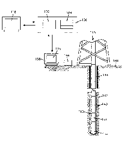
[0014] FIG. 1 is a block diagram of a survey quality assurance tool in an
example
environment.
[0015] FIG. 2 illustrates a method of communicating rig site data from a
rig site to a
remote operating center using the survey quality assurance tool of FIG. 1.
[0016] FIGS. 3 and 4 show an example process workflow for survey quality
assurance and MWD data transfer using the survey quality assurance tool of
FIG. 1.
DETAILED DESCRIPTION
[0017] A survey quality assurance tool that facilitates quality control and
correction
of survey data is disclosed herein. In one embodiment, the survey quality
assurance tool
provides an interface between rig site users and remote operating centers
using web
technology. The survey quality assurance tool optimizes the transfer of
directional
survey data from rig site to remote operating centers in such a way that
minimizes
time-consuming steps while simultaneously providing automatic data validation
ensuring data integrity. The survey quality assurance tool is a leap forward
from
traditional methods of emailing text files and spreadsheets between end users
because
it not only speeds up the entire process but also significantly reduces the
occurrence of
transcription and clerical errors. The survey quality assurance tool is easily
accessible
almost anywhere in the world by simply logging in through a standard web
browser.
This eliminates the need for specialized software at the rig site and remote
operating
centers.
[0018] FIG. 1 is a simplified diagram of an illustrative survey quality
assurance tool
100 in an example environment. The survey quality assurance tool 100 includes
a web
application 102 and a database 104. As used herein, the term "web application"
refers to
an application program that is stored on a remote server and delivered over
the
Internet through a browser interface. The web application 102 includes logic
and other
processes for receiving survey measurements, verifying the survey measurements
using
one or more quality control metrics, alerting the rig if the survey
measurements fail any
of the quality control metrics, making the survey measurements available for
corrective
survey data analysis at a remote site, and making corrected survey
measurements
available for drilling of a wellbore at the rig. The database 104 is used to
store raw
survey data and corrected survey data. In one embodiment, the web application
102
and database 104 are deployed in a cloud 106. The term "cloud" is used in the
sense that

CA 02991242 2018-01-02
WO 2017/007967 PCT/US2016/041394
the web application 102 and database 104 are stored online and accessible via
a
standard web browser and Internet connection. The cloud 106 includes the
necessary
computing resources, such as processor(s) and memory, to run the web
application 102
and database 104 on-demand. In one example, the cloud 106 may include an
application
server 108 that exposes the logic and processes of the web application 102 and
a
database server 110 that provides database services.
[0019] The web application 102 is accessible from a standard web browser on
a
client device 112. Interaction with the web application 102 occurs through an
external
graphical user interface (GUI) 116 or an internal GUI 118, either of which may
be
displayed in the web browser on the client device 112. The terms "external"
and
"internal" are arbitrary. Typically, the external GUI 116 will be displayed to
a user
assigned a non-specialist role, typically a user at a rig site, and the
internal GUI 118 will
be displayed to a user assigned a specialist role, typically a user at a
remote operating
center. Access control 114 is used to restrict who can access the web
application 102
through the external GUI 116 and internal GUI 118 and what features of the web
application 102 can be accessed. Any authentication model suitable for use in
a cloud
environment may be used for the access control 114. Access control 114 may
include
displaying a login page in the web browser on the client device 112, receiving
a user
name and password from the browser, and checking the user name and password
against an access control list to see if the user may access the web
application 102 and
what role the user has when accessing the web application 102.
[0020] In one embodiment, the web application 102 includes logic for
receiving raw
survey data through the external GUI 116. The web application 102 may further
include
logic for performing quality control (QC) checks on the raw survey data. The
web
application 102 may further include logic for storing QC verified survey data
in the
database 104. The web application 102 may further include logic for making the
QC
verified survey data available on the internal GUI 118. The web application
102 may
further include logic for accepting corrected survey data through the internal
GUI 118.
The web application 102 may further include logic for performing QC checks on
the
corrected survey data. The web application 102 may further include logic for
storing
corrected survey data or QC verified corrected survey data in the database
104. The
web application 102 may further include logic for making the corrected survey
data
available on the external GUI 116. The web application 102 may further include
logic for
6

CA 02991242 2018-01-02
WO 2017/007967 PCT/US2016/041394
generating context appropriate notifications and making them available on the
client
device 112 through either of the external GUI 116 and internal GUI 118.
[0021] In one embodiment, the web application 102 is provided as computer
readable program instructions. In one embodiment, a computer program product
includes a computer readable storage medium on which the computer readable
program instructions are stored. The computer readable program instructions
can be
executed by one or more processors to cause a computer or computing
environment to
perform the actions indicated in the instructions. Examples of computer
readable
storage media include, but are not limited to, CD-ROMS, flash drives, RAM
chips, hard
drives, EPROMs, etc. The computer readable storage medium on which the web
application 102 is stored is non-transitory in that it does not include
carrier waves and
electronic signals passing wirelessly or over wired connections. In one
embodiment, the
computer readable program instructions representing the web application 102
can be
downloaded from the computer readable storage medium to respective
computing/processing devices or to an external computer or to an external
storage
device via a network.
[0022] FIG. 2 shows a wellbore 140 drilled in a subsurface formation 142. A
drill
string 144 extends from a rig 146 at the surface 148 into the wellbore 146. A
bottom-
hole assembly (BHA) 150 is appended at the lower end of the drill string 144.
The BHA
150 includes a drill bit 152 and may further include one or more downhole
tools
configured to perform one or more downhole operations. In one example, the BHA
150
includes a MWD tool 154. The MWD tool 154 may include three accelerometers and
three magnetometers positioned in three orthogonal axes for making survey
measurements. The MWD tool 154 may be operated to make survey measurements at
selected depths in the wellbore. The survey measurements may be sent to a MWD
unit
156 on the rig 146 by suitable wellbore telemetry, such as mud pulse
telemetry, wired
drill pipe telemetry, or electromagnetic telemetry. The MWD unit 156 may
include
MWD decoding software for decoding the survey measurements. The survey data
may
be transmitted from the MWD unit 156 to a rig computer 158 and displayed on
the rig
computer.
[0023] In one embodiment, a user on the rig 146 logs into the web
application 102
from a standard browser. The standard browser may be accessed through the rig
computer 158, for example. The web application presents an external GUI 116 to
the
7

CA 02991242 2018-01-02
WO 2017/007967 PCT/US2016/041394
user inside the browser. Through the external GUI 116, the rig user may enter
the raw
survey data into predefined fields or may upload an electronic file containing
the raw
survey data and then submit the data. The electronic file may be provided as a
plain text
file, a spreadsheet file, e.g., CSV file and the like, or a markup language
file, e.g., XML file.
Alternatively, an integration plug-in may be provided that enables the web
application
102 to integrate with the MWD unit 156 and receive the survey data directly
from the
MWD unit 156 without requiring user input. The web application 102 may receive
the
survey data in response to a prompt from the user through the external GUI
118. The
web application 102 may display the received data and allow the user to submit
the
data, e.g., by the click of a button on the external GUI 116. For MWD surveys,
the
submitted data may include the following: survey depth, inclination, azimuth,
date, time,
run number, survey type, X, Y, and Z accelerometer measurements, and X, Y, and
Z
magnetometer measurements. In addition, well information, such as well name,
rig
name, north reference, and survey tool type, may be provided to the web
application
along with the survey data.
[0024] FIG. 3 is a flow chart illustrating an example process workflow for
survey
quality assurance and MWD data transfer using the survey quality assurance
tool.
[0025] At 100, survey measurements are made at a survey station, or
selected
position, in the wellbore using the MWD tool.
[0026] At 102, the survey measurements are sent to the MWD unit on the rig
and
decoded. The raw survey data and well information are displayed on the rig
computer.
[0027] At 104, the raw survey data is submitted to the web application. Any
of the
methods described above may be used to submit the raw survey data to the web
application.
[0028] At 106, the web application verifies that the submitted survey data
meets
minimum data requirements. At a minimum, the submitted survey data should
include
the survey depth, inclination, and azimuth and the corresponding B total, G
total, and
Dip or the 6 axis data (accelerometer and magnetometer measurements). If the
submitted data does not meet the minimum data requirement, the web application
rejects the raw survey data, as shown at 108. At this point, new raw survey
data may be
submitted by returning to step 104.
[0029] At 109, if the submitted data meets the minimum data requirement, a
set of
parameters useful in QC validation of the survey data is calculated. The set
of
8

CA 02991242 2018-01-02
WO 2017/007967 PCT/US2016/041394
parameters may include inclination, azimuth, G total (strength of the gravity
field), B
total (strength of the magnetic field), and Dip (direction of magnetic field
with respect
to horizontal plane), reference values for total gravity, field strength, dip
angle,
declination, and grid convergence, and QC tolerances. Inclination and azimuth
are
calculated from the corresponding 6 axis accelerometer and magnetometer
measurements if the 6 axis measurements are included in the submitted data.
The QC
tolerances are computed from the error coefficients specified in the tool code
and scaled
to the same sigma level used for collision avoidance planning. QC tolerances
are
calculated for measured depth, inclination, azimuth, A inclination, A azimuth,
G total, B
total, and Dip. QC tolerances can be calculated similarly to how measured
depth,
inclination and azimuth errors are calculated from tool code. (See, Maus,
Stefan, Croke,
Ryan. 2014. Field acceptance criteria based on ISCWSA tool error models.
Presented at
the ISCWSA meeting, Long Beach, 9 May 2014.)
[0030] At 110, a first QC check is made. The first QC check verifies that
the submitted
data is free of gross error due to incorrect data submission. Incorrect data
submission
may arise from the user entering the wrong data in the predefined fields in
the external
GUI or uploading the wrong file or a corrupt file through the external GUI.
For the first
QC check, if inclination and azimuth are calculated in step 109, the
calculated inclination
and azimuth (step 109) are compared to the rig reported inclination and
azimuth (i.e.,
the inclination and azimuth stated in the raw survey data). If there are
significant
differences between the calculated inclination and azimuth and the rig
reported
inclination and azimuth, the submitted data will be considered as failing the
first QC
check. The first QC check also provides an independent check against the north
reference, grid correction, and magnetic reference values being applied. North
reference, grid correction, and magnetic reference are variables used to
compute the
azimuth. Thus if the calculated azimuth is correct, it can be concluded that
the north
reference, grid correction, and magnetic reference values being applied by the
rig are
correct.
[0031] At 112, a second QC check is made. The second validation check
verifies that
the survey QC measurements and systematic errors are within the QC tolerance
limits
computed at step 109. The survey measurement is validated against the tool
code by
evaluating differences between the measured values and reference values of B
total,
Dip, and G total, i.e., A B total, A Dip, and A G total, using the appropriate
QC tolerances.
9

CA 02991242 2018-01-02
WO 2017/007967 PCT/US2016/041394
If the A B total, A Dip, and A G total fall outside the calculated QC
tolerance limits, then
the survey measurement has greater error than what was modeled by the tool
code
EOUs and the anti-collision assessment may be invalid. If A B total, A Dip,
and A G total
fall outside the calculated QC tolerance limits, the submitted data will be
considered as
failing the second QC check.
[0032] At 114, a third QC check is made. The third QC check verifies that
the data
quality is adequate and free from gross errors due to environmental factors or
instrument failure. The third QC check evaluates the current survey against
the surveys
taken at previous survey stations in order to identify trends that could alert
the driller
to gross errors indicative of external magnetic interference from offset well
casing or a
failing instrument. The third QC check may involve computing A B total, A Dip,
and A G
total (deltas) for each previous survey. These deltas or residuals will vary
from one
survey to the next. By evaluating the variances, the standard deviation across
an entire
data set consisting of the previous surveys can be calculated. The deltas for
the current
survey can be computed. The deltas for the current survey can be compared to
the
standard deviation to determine if the current survey is a statistical
outlier. For
example, if the differences between the deltas for the current survey
measurements and
the standard deviations exceed a certain threshold, such as 3 sigma, then the
current
survey could be considered a statistical outlier and suggest that there is a
particular
problem, such as poor telemetry decode or the BHA is in near proximity to an
offset
wellbore. If the current survey is a statistical outlier, the submitted data
will be
considered as failing the third QC check.
[0033] Although the terms first, second, and third QC checks are used, it
should be
clear that the QC checks can be performed in any order. Also, parts of step
109 can be
completed while performing the QC checks.
[0034] At 116, the rig user is notified of the results of the QC checks.
This may
include displaying notices of any failed QC checks on the external GUI as well
as
displaying corresponding QC plots on the external GUI.
[0035] The QC checks of 110 to 116 can be fully automated and can occur
almost as
soon as the survey measurements are received on the rig. This allows an
opportunity to
give immediate feedback to the rig site personnel if there is a problem.
Alerting the rig
to potential problems in a timely manner creates an opportunity to reshoot the
survey
or elevate the concern to management before drilling begins again.

CA 02991242 2018-01-02
WO 2017/007967
PCT/US2016/041394
[0036] At 118, the process checks if the rig wants to reshoot the survey.
If the rig
does not want to reshoot the survey, the process goes to 120. If the rig
wishes to
reshoot the survey, e.g., because the survey data did not pass one or more of
the QC
validation tests, the process returns to 100.
[0037] At 120, the raw survey data is added to the survey set in the
database. If the
raw survey data failed any of the QC validation tests, the raw survey data may
be
flagged as such. Once the survey data is stored in the database on the cloud,
the survey
data can be accessed at a remote operating center through the internal GUI.
[0038] While the QC checks work well to detect potential problems in the
survey
quality, it does very little to identify the underlying cause of the problem
or distinguish
between the various sources of error. However, the survey data can be further
evaluated using corrective survey data analysis techniques, such as multi-
station
analysis techniques, to determine individual error components attributed to
sensor
bias, scale, and misalignment. Trend analysis is also useful for recognizing
patterns
characteristic of magnetic drillstring interference, magnetic mud, and other
environmental factors that contribute to survey error.
[0039] Referring to FIG. 4, at 122, a MWD specialist at a remote operating
center
downloads the survey data through the internal GUI.
[0040] At 124, the survey data is evaluated at the remote operating center.
The
survey data may be evaluated using one or more corrective survey data analysis
techniques, such as multi-station analysis and other trend analysis
techniques. Multi-
station analysis is a technique widely used in the industry to correct
systematic errors
of magnetic MWD surveys associated with drillstring interference. (See, Nyres,
Erik, et
al., "Minimum Requirements for Multi-Station Analysis of MWD Magnetic
Directional
Surveys," Presented at SPE/IADC Middle East Drilling Technology Conference &
Exhibition held in Manama, Bahrain, 26-28, October 2009, SPE/IADC 125677, and
Brooks, A.G., et al., "Practical Application of a Multiple-Survey Magnetic
Correction
Algorithm," Presented at the 1998 SPE Annual Technical Conference and
Exhibition
held in New Orleans, Louisiana, 27-30 September 1998, SPE 49060.)
[0041] At 126, from the evaluation of 124, bias, scale, misalignment terms
for each
sensor in the MWD tool are identified. Other sources of error, i.e.,
drillstring
interference, magnetic mud, and the like, are also identified.
11

CA 02991242 2018-01-02
WO 2017/007967 PCT/US2016/041394
[0042] At 128, the process involves checking if survey corrections are
needed from
the results of 126. If survey corrections are needed, the survey data is
corrected at 130.
The corrected survey data may be subject to QC checks similar to steps 110
through 114
in FIG. 3.
[0043] At 132, the QC-verified raw survey data or corrected survey data is
added to
the wellbore trajectory definitive listing in the database. The surveys on the
wellbore
trajectory definitive listing can be used to compute the wellbore trajectory
during
drilling of the wellbore.
[0044] At 134, the corrected survey data, or the last survey added to the
wellbore
trajectory definitive listing, is displayed at the rig using the external GUI.
The process
returns to 100 for the next survey measurement.
[0045] While the invention has been described with respect to a limited
number of
embodiments, those skilled in the art of, having benefit of this disclosure,
will
appreciate that other embodiments can be devised which do not depart from the
scope
of the invention as disclosed herein. Accordingly, the scope of the invention
should be
limited only by the accompanying claims.
12

Representative Drawing
A single figure which represents the drawing illustrating the invention.
Administrative Status

2024-08-01:As part of the Next Generation Patents (NGP) transition, the Canadian Patents Database (CPD) now contains a more detailed Event History, which replicates the Event Log of our new back-office solution.

Please note that "Inactive:" events refers to events no longer in use in our new back-office solution.

For a clearer understanding of the status of the application/patent presented on this page, the site Disclaimer , as well as the definitions for Patent , Event History , Maintenance Fee  and Payment History  should be consulted.

Event History

Description Date
Letter Sent 2023-10-10
Inactive: Grant downloaded 2023-10-10
Grant by Issuance 2023-10-10
Inactive: Cover page published 2023-10-09
Pre-grant 2023-08-28
Inactive: Final fee received 2023-08-28
Letter Sent 2023-05-02
Notice of Allowance is Issued 2023-05-02
Inactive: Approved for allowance (AFA) 2023-04-20
Inactive: QS passed 2023-04-20
Amendment Received - Voluntary Amendment 2023-02-10
Amendment Received - Response to Examiner's Requisition 2023-02-10
Examiner's Report 2022-10-13
Inactive: Report - No QC 2022-09-21
Letter Sent 2021-07-21
Amendment Received - Voluntary Amendment 2021-07-12
Request for Examination Requirements Determined Compliant 2021-07-06
All Requirements for Examination Determined Compliant 2021-07-06
Request for Examination Received 2021-07-06
Common Representative Appointed 2020-11-07
Change of Address or Method of Correspondence Request Received 2020-05-08
Common Representative Appointed 2019-10-30
Letter Sent 2019-01-21
Inactive: Reply to s.37 Rules - PCT 2019-01-10
Inactive: Single transfer 2019-01-10
Inactive: Cover page published 2018-03-12
Inactive: Notice - National entry - No RFE 2018-01-24
Inactive: IPC assigned 2018-01-23
Application Received - PCT 2018-01-17
Inactive: IPC assigned 2018-01-17
Inactive: First IPC assigned 2018-01-17
National Entry Requirements Determined Compliant 2018-01-02
Application Published (Open to Public Inspection) 2017-01-12

Abandonment History

There is no abandonment history.

Maintenance Fee

The last payment was received on 2023-06-21

Note : If the full payment has not been received on or before the date indicated, a further fee may be required which may be one of the following

  • the reinstatement fee;
  • the late payment fee; or
  • additional fee to reverse deemed expiry.

Patent fees are adjusted on the 1st of January every year. The amounts above are the current amounts if received by December 31 of the current year.
Please refer to the CIPO Patent Fees web page to see all current fee amounts.

Fee History

Fee Type Anniversary Year Due Date Paid Date
Basic national fee - standard 2018-01-02
MF (application, 2nd anniv.) - standard 02 2018-07-09 2018-06-05
Registration of a document 2019-01-10
MF (application, 3rd anniv.) - standard 03 2019-07-08 2019-06-05
MF (application, 4th anniv.) - standard 04 2020-07-07 2020-06-05
MF (application, 5th anniv.) - standard 05 2021-07-07 2021-06-22
Request for examination - standard 2021-07-07 2021-07-06
MF (application, 6th anniv.) - standard 06 2022-07-07 2022-06-22
MF (application, 7th anniv.) - standard 07 2023-07-07 2023-06-21
Final fee - standard 2023-08-28
MF (patent, 8th anniv.) - standard 2024-07-08 2024-06-18
Owners on Record

Note: Records showing the ownership history in alphabetical order.

Current Owners on Record
SURCON LTD
Past Owners on Record
JARROD SHAWN DEVERSE
STEFAN MAUS
Past Owners that do not appear in the "Owners on Record" listing will appear in other documentation within the application.
Documents

To view selected files, please enter reCAPTCHA code :


To view images, click a link in the Document Description column. To download the documents, select one or more checkboxes in the first column and then click the "Download Selected in PDF format (Zip Archive)" or the "Download Selected as Single PDF" button.

List of published and non-published patent-specific documents on the CPD .

If you have any difficulty accessing content, you can call the Client Service Centre at 1-866-997-1936 or send them an e-mail at CIPO Client Service Centre.


Document
Description 
Date
(yyyy-mm-dd) 
Number of pages   Size of Image (KB) 
Representative drawing 2023-09-28 1 15
Description 2018-01-01 12 622
Abstract 2018-01-01 2 68
Drawings 2018-01-01 4 145
Claims 2018-01-01 7 253
Representative drawing 2018-01-01 1 34
Claims 2021-07-11 6 273
Description 2023-02-09 12 920
Claims 2023-02-09 14 848
Maintenance fee payment 2024-06-17 51 2,098
Courtesy - Certificate of registration (related document(s)) 2019-01-20 1 106
Notice of National Entry 2018-01-23 1 205
Reminder of maintenance fee due 2018-03-07 1 111
Courtesy - Acknowledgement of Request for Examination 2021-07-20 1 424
Commissioner's Notice - Application Found Allowable 2023-05-01 1 579
Final fee 2023-08-27 6 149
Electronic Grant Certificate 2023-10-09 1 2,527
National entry request 2018-01-01 6 148
International search report 2018-01-01 1 58
Declaration 2018-01-01 1 15
Response to section 37 2019-01-09 5 120
Request for examination 2021-07-05 3 125
Amendment / response to report 2021-07-11 11 417
Examiner requisition 2022-10-12 3 151
Amendment / response to report 2023-02-09 23 1,064