Note: Descriptions are shown in the official language in which they were submitted.
CA 02991427 2018-01-04
WO 2017/014971
PCT/US2016/041705
AGRICULTURAL CROP ANALYSIS DRONE
TECHNICAL FIELD
[0001] The present invention relates generally to agricultural farming, and,
more particularly, to an agricultural drone for use in combination with
agricultural
equipment.
BACKGROUND OF THE INVENTION
[0002] Modern farming continues to make significant strides in the industry's
ability to produce larger and more robust foods in response to demand and
increasing populations. For
example, advances in chemical engineering,
fertilization, irrigation, soil analysis and equipment (hardware and software)
have
revolutionized crop production and associated systems. In this evolution of
farming techniques, modern farming has increasingly turned to technological
advances in the full stream of farming such as planting, tending and
harvesting of
crops which requires a wide range of tools, equipment, machinery, chemicals
and other materials.
[0003] For example, vehicle mounted spraying systems incorporating a boom
that extends laterally on both sides of a vehicle such as a tractor are
commonly
used to spray agricultural crops with liquid based products such as
fertilizers or
other chemicals. Typically, these types of spraying systems are mounted to the
rear of the vehicle which will also carry a tank containing the liquid that is
to be
sprayed. To ensure that the correct amount of liquid is sprayed, the spraying
system is configured so that a given flow rate is dispensed from a plurality
of
sprayers located along the arm at a predetermined height above the surface to
be sprayed. Often these vehicle mounted spraying systems will incorporate a
height adjustment capability to allow the overall height of the boom to be
adjusted as desired. Booms vary in size, with typical wing tip to wing tip
lengths
of 90 feet, 120 feet and 150 feet.
1
CA 02991427 2018-01-04
WO 2017/014971
PCT/US2016/041705
[0004] Such spraying systems prove very adequate over flat terrain, however,
where the surface to be sprayed is undulating or sloped simple height
adjustment
of the boom relative to the vehicle is not sufficient as the ground to the
right of
the vehicle may be elevated with respect the ground surface to the left of the
vehicle. To overcome this problem, the boom is commonly divided into separate
articulated arms or wings each of which are independently adjustable by
hydraulic rams which function to raise or lower the booms in accordance with a
control signal provided by ultrasonic distance sensors located on each wing.
These distance sensors measure the distance between the wing and the ground
surface. In this manner, either the left or right wing of the boom may be
automatically raised or lowered as required.
[0005] However, there are a number of disadvantages with this approach. As
the wings extend for relatively large distances from the vehicle, the wings
are
mounted to a central rigid support structure which itself is resiliently
mounted to
the vehicle. This resilient mounting includes a combination of springs, shock
absorbers and pendulums so as to absorb severe twisting and movement shocks
and provide some mechanical self levelling of the boom. This mounting also
provides approximately 100 of travel in the roll direction which functions to
absorb the significant stresses that the central support structure would
otherwise
encounter if it were to be rigidly mounted to the vehicle.
[0006] Unfortunately, the effect of this resilient mounting is to greatly
reduce
the stability of the wing height control as, for example, raising the left
wing to
compensate for a raised ground profile in this region will in fact cause the
right
wing to pivot upwardly due to the torque imparted on the entire boom by the
redistribution of weight on the left hand side. This will then result in a
control
signal being sent to the right hand side to lower the right wing, thereby
leading to
a potential instability. Eventually, the boom will reach equilibrium but only
after a
delay of approximately one to three seconds during which time the sprayed
liquid
will not be dispensed in the correct amounts over the ground.
2
CA 02991427 2018-01-04
WO 2017/014971
PCT/US2016/041705
[0007] Another significant disadvantage of existing vehicle mounted spray
systems occurs when the vehicle encounters a local undulation in the surface
such as a rock or a rut in the ground that causes the vehicle to rapidly
change
lateral slope angle. In extreme circumstances, this could cause the tip of a
wing
to impact the ground as the speed of response of the ultrasonic distance
sensors
located on the wings is not rapid enough to prevent this from occurring. Even
in
the case where an impact is avoided, the raising of the wing to avoid the
impact
will cause the raising of the opposed wing as discussed earlier, once again
resulting in a certain instability of the spraying system.
[0008] As highlighted above, the terrain over which such sprayers systems
operate can heavily impact the overall stability of the sprayer and the
performance of the sprayer in terms of dispensing the specific liquid (e.g.,
fertilizer) at the desired rate and coverage area. In the
field of precision
agriculture, agricultural drones and/or so-called unmanned aerial vehicles
(UAV)
exist that are used to study terrains and have been used to capture highly
accurate images of fields and crops that cover hundreds of hectares/acres in a
single flight. Such image data is combined with available post-flight
data/image
processing software to transform the captured images into, for example, one or
more orthomosaic images and/or digital elevation models, generate custom
vegetation indices to detect structural, chlorophyll and water stresses and/or
evaluate irrigation management. For example, the images and other information
collected by such agricultural drones can be analyzed on a post-flight basis
using
available image processing and data processing software that will provide
normalized differential vegetation index (NDVI) maps, 2D index maps, 2D geo-
referenced orthomosaics, 3D textured mesh, 3D digital surface models (DSM),
contour lines, application maps, thermal field maps, reflectance maps and
other
crop monitoring/analysis. For example, a post-flight reflectance map (in a
well-
known shapefile (SHP) format) of selected crops can be imported into available
3
=
CA 02991427 2018-01-04
farm management software for further diagnosis and/or imported directly into a
tractor console. However, such analysis is on a post-flight basis.
[0009] Therefore, a need exists for an improved technique that utilizes
agricultural drones to improve the use, control and effectiveness of
agricultural
boom sprayers in real-time.
BRIEF SUMMARY OF THE EMBODIMENTS
[0010] In accordance with various embodiments, one or more agricultural
drones are used in combination with agricultural equipment, e.g., an
agricultural
boom sprayer, to improve the real-time delivery and dispensing of liquid from
the sprayer including monitoring and verifying that the liquid is being
dispensed
correctly and/or in accordance with a desired distribution pattern or level.
[0010a] Certain exemplary embodiments can provide a method for agricultural
farming, the method comprising: collecting information specific to a plurality
of
crops at a first agricultural drone; and transmitting the collected
information in
real-time from the first agricultural drone to an agricultural vehicle
traversing the
plurality of crops, the first agricultural drone operating independently from
the
agricultural vehicle; receiving, by the agricultural vehicle, the collected
information from the first agricultural done in real-time; adjusting, in real-
time, by
the agricultural vehicle at least one operation of the agricultural vehicle
using
the received collected information from the first agricultural drone; and
wherein
the agricultural vehicle is a boom sprayer, the first agricultural drone is
flying in
a position in advance of the agricultural vehicle, and the adjusting, in real-
time,
by the boom sprayer includes a leveling of the boom sprayer wherein the
leveling is achieved independent of any information collected by one or more
sensors resident on the boom sprayer.
[0010b] Certain exemplary embodiments can provide a method for agricultural
farming, the method comprising: collecting information specific to a plurality
of
crops at a first agricultural drone; and transmitting the collected
information in
real-time from the first agricultural drone to an agricultural vehicle
traversing the
plurality of crops, the first agricultural drone operating independently from
the
4
=
CA 02991427 2018-01-04
agricultural vehicle; receiving, by the agricultural vehicle, the collected
information from the first agricultural done in real-time; adjusting, in real-
time, by
the agricultural vehicle at least one operation of the agricultural vehicle
using
the received collected information from the first agricultural drone; and
analyzing, at the first agricultural drone, the collected information to
identify
individual crops of the plurality of crops suffering from drought or under-
fertilization.
[0011] More
particularly, in accordance with an embodiment, one or more
agricultural drones are dispatched to fly in advance of (i.e., in front of)
and in
proximity to an agricultural boom sprayer with the agricultural drone
collecting
real-time topology, elevation and other information (collectively referred to
herein as "crop analysis information") with respect to the crops and/or
terrain
being sprayed. Such crop analysis information may include multispectral and/or
hyperspectral pictures. In accordance with the embodiment, the flying of the
drone and the traversing of the crops by the agricultural boom sprayer occur
substantially contemporaneously. In turn, the agricultural drone communicates
such crop analysis information to the agricultural sprayer operating behind
the
inflight agricultural drone so that the sprayer can utilize the real-time crop
analysis information to operate the sprayer. The real-time analysis can be
performed directly by the drone and communicated to the sprayer for action, or
the underlying data can be transmitted from the drone to the sprayer console
for
completion of the data manipulation and analysis. For example, the crop
analysis information can be used to stabilize the sprayer (e.g., in the event
that
RGG pictures of transformed into 3D maps of the canopy geometry defined by
4a
CA 02991427 2018-01-04
WO 2017/014971
PCT/US2016/041705
the plurality of crops) or level the boom sprayer in order to improve
dispensing of
the liquid being applied at that time.
[0012] In accordance with a further embodiment, one or more agricultural
drones are dispatched to fly in back of and in proximity to an agricultural
boom
sprayer with the drone collecting real-time dispensing information
(collectively
referred to herein as "dispensing information") with respect to performance
and
effectiveness of the liquid being dispensed by the boom sprayer. In accordance
with this embodiment, the flying of the agricultural drone and the traversing
of the
crops by the agricultural boom sprayer occur substantially contemporaneously.
In turn, the agricultural drone communicates such crop analysis information to
the agricultural sprayer operating ahead of the in-flight agricultural drone
so that
the sprayer can utilize the dispensing information to make appropriate
adjustments to improve the overall sprayer performance. For
example, the
dispensing information can be used to measure the real-time level of liquid
being
applied to a section of crops and whether the liquid is actually being
dispensed at
the desired rate or level.
[0013] These and other advantages of the embodiments will be apparent to
those of ordinary skill in the art by reference to the following detailed
description
and the accompanying drawings.
BRIEF DESCRIPTION OF THE DRAWINGS
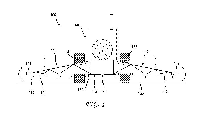
[0014] FIG. 1 shows a rear elevation view of an illustrative agricultural boom
sprayer in accordance with an illustrative embodiment;
[0015] FIG. 2 shows a high-level block diagram of a crop analysis unit which
is
integral with the agricultural boom sprayer of FIG. 1 in accordance with an
embodiment;
[0016] FIG. 3 shows an illustrative agricultural drone in accordance with an
embodiment;
CA 02991427 2018-01-04
WO 2017/014971
PCT/US2016/041705
[0017] FIG. 4 shows a high-level block diagram of on-board electronics which
is integral with the agricultural boom drone of FIG. 3 in accordance with an
embodiment;
[0018] FIG. 5 shows an explanatory diagram of the use, in accordance with an
embodiment, of the agricultural boom sprayer configured in accordance with
FIG.
1 and FIG. 2 in combination with an agricultural drone configured in
accordance
with FIG. 3 and FIG. 4;
[0019] FIG. 6 shows an explanatory diagram of the use, in accordance with an
embodiment, of the agricultural boom sprayer configured in accordance with
FIG.
1 and FIG. 2 in combination with multiple agricultural drones configured in
accordance with FIG. 3 and FIG. 4;
[0020] FIG. 7 shows a flowchart of illustrative operations for agricultural
farming utilizing an agricultural drone(s) for agricultural crop analysis in
accordance with an embodiment; and
[0021] FIG. 8 is a high-level block diagram of an alternative exemplary crop
analysis unit in accordance with an embodiment.
DETAILED DESCRIPTION
[0022] In accordance with various embodiments, one or more agricultural
drones are used in combination with an agricultural boom sprayer to improve
the
real-time delivery and dispensing of liquid from the sprayer including
monitoring
and verifying that the liquid is being dispensed correctly and/or in
accordance
with a desired distribution pattern or level.
[0023] FIG. 1 shows a rear elevation view of an illustrative agricultural
sprayer
100 in accordance with an illustrative embodiment of the present invention.
Agricultural boom sprayer 100 comprises a vehicle 160 which in this case is a
tractor and includes a boom section 110 incorporating a pair of opposed wing
sections 111 and 112 mounted to a central support structure 113 which in turn
is
mounted to vehicle 160 by a resilient mounting arrangement 120 as is well-
6
CA 02991427 2018-01-04
WO 2017/014971
PCT/US2016/041705
known. The boom section 110 includes a raising means (not shown), which
allows the entire boom 110 to be raised to a predetermined height with respect
to
the tractor 160 while ensuring that spray nozzles 115 continue to point in a
downward direction. The raising means utilizes hydraulic rams and may be via,
illustratively, a parallelogram mechanical method where the central support
structure 113 is raised by a series of parallel linkage arms (not shown)
extending
rearward and downwardly from the resilient mounting arrangement 120 in a well-
known fashion.
[0024] Each wing 111 and 112 may be separately articulated by a
corresponding hydraulic ram 131 and 132 which function to separately raise and
lower each wing 111 and 112 in accordance with control signals provided by a
hydraulic control system (not shown). Distance sensors 141 and 142 are
mounted at the tips of each wing 111 and 112 and measure the positions or
heights of the tips of each wing 111 and 112. Alternatively one or more
distance
sensors may be mounted at other locations along a wing to provide position or
height information at their respective position. Distance sensor 143 is also
mounted on the support structure 113. These sensors allow the difference in
the
height of the wing tip relative to the center of the support structure to be
calculated (i.e. the wing height error). The principles embodied by the
various
embodiments herein apply equally to various agricultural sprayer and boom
sprayer configurations as such the illustrative configuration of FIG. 1 is one
of
many such configurations in which the principles and advantages of the
disclosed embodiments apply.
[0025] In accordance with an embodiment, agricultural boom sprayer 100 is
configured with crop analysis unit 200 as shown in FIG. 2. Crop analysis unit
200 includes communication unit 205 having transceiver 220, Wi-Fi controller
225 and antenna 230, central processing unit 210, and memory 215. As detailed
further herein below, crop analysis unit 200, being integral with agricultural
boom
sprayer 100, will facilitate real-time communications between agricultural
boom
7
CA 02991427 2018-01-04
WO 2017/014971
PCT/US2016/041705
sprayer 100 and one or more agricultural drones flying in proximity thereto in
order to improve the delivery and dispensing of liquid from such sprayers
including monitoring and verifying that the liquid is being dispensed
correctly.
[0026] In
particular, FIG. 3 shows an illustrative agricultural drone 300 in
accordance with an embodiment. As shown, agricultural drone 300 includes a
lightweight body and wings 310, motor assembly 320, built-in GNSS/RTK/PPP
receiver 330, built-in camera 340, pilot tube 350 and antenna 360. Of course,
agricultural drone 300 will include other components and functionality not
depicted in FIG. 3 such as batteries, ground sensors, onboard electronics and
communications, onboard artificial intelligence, collision avoidance, to name
a
few. One such commercially available agricultural drone is the eBee Ag drone
sold by senseFly Ltd, Route de Geneve 38, 033 Cheseaux-Lausanne,
Switzerland.
Agricultural drone 300 is fully autonomous and will fly in
accordance with a predefined flight plan and in the case of agricultural
applications the drone will capture highly accurate images of a particular
field or
fields (having a single crop or a plurality of crops) covering hundreds of
hectares/acres in a single flight.
[0027] FIG. 4 shows a high-level block diagram of on-board electronics 400
which are integral with agricultural drone 300 of FIG. 3 in accordance with an
embodiment. As shown, on-board electronics 400 includes high precision
positioning unit 405 having positioning/communications module 410 (e.g., a
GPS/GLONOSS/GALILEO/BEIDOU positioning/communications module) and
antenna 415 which communicates, via communications link 401, with
GPS/GLONOSS/GALILEO/BEIDOU network 490 in a well-known fashion,
communication unit 420 having transceiver 425, Wi-Fi module 430 and antenna
435 which interfaces with at least RTK corrections broadcast 495 over
communications link 402 in a well-known fashion, guidance unit 440, central
processing unit (CPU) 445, accelerometer 450, gyro 455, magnetometer 460,
camera and vision unit 465, power unit 470 having batteries 475-1 through 475-
3
CA 02991427 2018-01-04
WO 2017/014971
PCT/US2016/041705
and power distribution board 480 which interfaces with rechargeable power
supply 485 in a well-known fashion. In accordance with the embodiment,
agricultural drone 300 will transmit and communicate real-time communications
and information to agricultural boom sprayer 100 as configured with crop
analysis
unit 200 (as shown illustratively in FIG. 4), via communication link 403,
utilizing
communications unit 420 with respect to a particular field and/or crops under
investigation by agricultural drone 300.
[0028] For example, FIG. 5 shows an explanatory diagram 500 of an
embodiment utilizing agricultural boom sprayer 100 configured in accordance
with FIG. 1 and FIG. 2 (as shown illustratively in FIG. 4) in combination with
agricultural drone 500 which is configured the same as agricultural drone 300
in
accordance with FIG. 3 and FIG. 4. As shown, agricultural drone 540 is flying
over field 510 having a plurality of crops 520. It will be understand that the
plurality of crops may be any kind (one or many) of crop, vegetable, grain or
vegetation or other plant grown on typical agricultural farms. This flyover by
agricultural drone 540 will be in accordance with a defined flight plan in a
well-
known manner during which agricultural drone 540 will be collecting real-time
information with respect to field 510 and/or plurality of crops 520. In this
embodiment, agricultural drone 540 is flying and maintaining a position in
front of
agricultural boom sprayer 100. In accordance with this embodiment, the flying
of
agricultural drone 540 and the traversing of the crops by agricultural boom
sprayer 100 occur substantially contemporaneously. Such real-time information
will include elevation data, contour data, topology data crop data and/or crop
analysis which can be utilized, in accordance with an embodiment, to provide
real-time communications, over communications link 530, to agricultural boom
sprayer 100 that will assist in improving the performance of agricultural boom
sprayer 100. As will be noted throughout the discussion herein, the terms
"front"
and "back" are utilized to denote different positions of the agricultural
drone
relative to the agricultural boom sprayer. That is, "front" may designate a
position
9
CA 02991427 2018-01-04
WO 2017/014971
PCT/US2016/041705
in advance of the agricultural boom sprayer as the vehicle traverses the field
in a
forward position (e.g., from an easterly position to a westerly position on
the field)
and the term "back" may designate a position behind the agricultural sprayer
as
the vehicle traverses the field. As such, if the agricultural boom sprayer
reverses
its position (e.g., now traversing the field from west to east) it will be
understood
that a "front" position can then become a "back" position, and vice versa. The
point being that such terms are used to designate different positions of the
agricultural drone(s) flying relative to the agricultural boom sprayers as
they fly
and traverse, as the case may be, a particular field(s) and/or crop(s).
[0029] For example, referring back to FIG. 1, typically distance sensors 141,
142 and 143 employ ultrasonic ranging to measure the height of the sensor
above the surface (e.g., field 510) being sprayed. For
example, ultrasonic
sensors in the MA40 series produced by the Murata Manufacturing Company
may be used. As shown in FIG. 1, ultrasonic distance sensors are placed near
each wing tip for wing height measurements, and on the support structure 113
for
measurements of the reference height.
Alternatively, two or more distance
sensors may be mounted on support structure 113 to increase the reliability of
the reference height measurement. Typically, multiple distance sensors can be
located on a wing and these can also be averaged or otherwise combined to
improve the estimate of the respective wing height and ultimately assist in
leveling agricultural sprayer 100 as it traverses over field 510. However, in
such
typical sensor arrangements, the number of points utilized for such leveling
estimations is limited by the number of sensors made available on boom section
110 of agricultural sprayer 100.
[0030] Advantageously, in accordance with an embodiment, the real-time
information collected by agricultural drone 540 such as elevation data,
contour
data, topology data, crop data and/or crop analysis will be utilized and
communicated, over communications link 530, to agricultural sprayer 100 to
assist with stabilizing and leveling boom section 110 as agricultural boom
sprayer
CA 02991427 2018-01-04
WO 2017/014971
PCT/US2016/041705
100 traverses over field 510 dispensing liquid 550 (e.g., fertilizer or
pesticide)
over plurality of crops 510. Communications link 530 is, illustratively, a
wireless
communications link established over wireless infrastructure, such as a third
party supplied cellular or Wi-Fi network, but in many cases where an existing
third party wireless infrastructure does not exist, the user must provide a
suitable
replacement. In such
cases, one type of a user supplied infrastructure
configuration is a narrowband single frequency radio system that may be
operated over field 510, for example. Such communication is realized with, for
example, Wi-Fi radios as well as cellular phones (e.g., 3G/4G/LTE/5G), UHF
radios and/or solid state radios.
[0031] As such, distance sensors 141,142 and 143 are no longer the primary
means for leveling boom section 110 and can be used as a secondary means of
leveling. In alternative embodiments, agricultural sprayer 100 can be
constructed
without such sensors if no secondary leveling means is desired or to save cost
or
space. Leveling algorithms will take into consideration the geometry of the
boom
leveling system and its distribution of actuators and dampers, for example,
and
the control system will receive as input data transmitted by the drone during
its
in-flight operations over the field and crops.
[0032] As such, the real-time information exchanged between agricultural
drone 540 and agricultural boom sprayer 100 allows for increased stability and
leveling precision of boom section 100 in that the type of and precision of
the
delivered real-time information far exceeds that of traditional leveling
techniques
of boom sprayers. Further, given that the conditions associated with field 510
and the plurality of crops 520 can change rapidly due to a variety of adverse
conditions (e.g., wind, rain, heat, animals, etc.), the application of
agricultural
drone 540 in real-time with agricultural boom sprayer 100 allows for the
mitigation of such adverse conditions and their overall impact on the spraying
of
the plurality of crops 520.
11
CA 02991427 2018-01-04
WO 2017/014971
PCT/US2016/041705
[0033] To that end, FIG. 6 shows an explanatory diagram 600 of an alternative
embodiment utilizing agricultural sprayer 100 again configured in accordance
with FIG. 1 and FIG. 2 (as illustratively shown in FIG. 4) in combination with
multiple agricultural drones configured in accordance with FIG. 3 and FIG. 4.
That is, agricultural drone 640 and agricultural drone 650 are each configured
that same as agricultural drone 300 in accordance with FIG. 3 and FIG. 4 and
flying over field 610 having a plurality of crops 620. These
flyovers by
agricultural drone 640 and agricultural drone 650 will be in accordance with a
defined flight plans in a well-known manner during which agricultural drone
640
and agricultural drone 650 will each be collecting real-time information with
respect to field 610 and plurality of crops 620. In this embodiment,
agricultural
drone 640 is flying in a position in front of agricultural sprayer 100 and is
performing substantially the same functions as detailed above in FIG. 5 with
respect to agricultural 500, as such these details will not be repeated here
with
agricultural drone 640 communicating over communications link 630-1 with
agricultural sprayer 100.
[0034] In
addition, agricultural drone 650 is flying in a position in back of
agricultural sprayer 100 and is collecting a variety of additional information
for
real-time communication, over communications link 630-2, with agricultural
sprayer 100. In accordance with this embodiment, the flying of the drone and
the
traversing of the crops by the agricultural boom sprayer occur substantially
contemporaneously. In particular, agricultural drone 650 is collecting
additional
real-time information directed to the efficiency and verification that liquid
660
(e.g., fertilizer or pesticide) is being dispensed correctly (e.g., at the
desired rate
or volume). If not, the real-time information communicated back to
agricultural
sprayer 100 will be utilized by the sprayer to adjust the dispensing of liquid
660
onto plurality of crops 620 to the desired level or rate, for example.
[0035] Further, in accordance with an embodiment, agricultural drone 640
(and/or agricultural drone 650) may be used to assist the farmers tending to
field
12
CA 02991427 2018-01-04
WO 2017/014971
PCT/US2016/041705
610 to identify individual crops of the plurality of crops 620 which may be
suffering or need additional further attention, for example, suffering from
drought
or under-fertilization. As such, agricultural drone 640 may be programmed (via
camera and vision unit 465 as shown in FIG. 4) to capture photographs and/or
videos of particular crops and such information can be transmitted (via
communications unit 420) to the farmer for analysis. Thereafter, the farmer
may
communicate further instructions back to agricultural drone 640 for further
information collection and/or making specified adjustments to agricultural
sprayer
100. The analysis may also provide the farmer with advance warning signs
directed to water or drainage conditions specific to a particular section of
field
610 and/or identify when harvesting of field 610 should occur and which crops
of
the plurality of crops 620 are mature enough for harvesting.
[0036] FIG. 7 shows a flowchart of illustrative operations 700 for
agricultural
farming utilizing agricultural drone(s) for agricultural crop analysis in
accordance
with an embodiment. In accordance with the operations of FIG. 7, at step 710,
an agricultural drone (i.e., a first agricultural drone) is flown in front of
an
agricultural boom sprayer that is traversing a field having a plurality of
crops and,
at step 720, collecting real-time information associated with the field and/or
the
plurality of crops (e.g., crop analysis, contour, elevation, etc., as detailed
herein
above) from the first agricultural drone. At step 730, the collected
information is
transmitted and communicated, in real-time, from the first agricultural drone
to
the agricultural boom sprayer, as detailed herein above, and, at step 740, the
agricultural boom sprayer utilizes the received information for adjustment
purposes (e.g., leveling the boom).
[0037] Advantageously, the real-time collection, communication and utilization
of agricultural specific information, in accordance with the embodiment, is
realized and exchanged between the agricultural drone and agricultural boom
sprayer for use in the immediate control of and adaption by the agricultural
boom
sprayer, as detailed herein above. In addition to the above-described steps,
13
CA 02991427 2018-01-04
WO 2017/014971
PCT/US2016/041705
there is also an option of monitoring, at step 750, the agricultural boom
sprayer
during operation. If such monitoring is desired, another agricultural drone
(i.e., a
second agricultural drone) is flown, at step 760, in back of the agricultural
boom
sprayer that is traversing the field having the plurality of crops and, at
step 770,
collecting real-time information associated with the field and/or the
plurality of
crops (e.g., crop analysis, fertilizer coverage, dispensed liquid levels, as
detailed
herein above) from the second agricultural drone. In accordance with this
embodiment, the flying of the drones and the traversing of the crops by the
agricultural boom sprayer occur substantially contemporaneously. At step 780,
the collected information is transmitted and communicated, in real-time, from
the
second agricultural drone to the agricultural boom sprayer, as detailed herein
above, and, at step 790, the agricultural boom sprayer utilized the received
information for adjustment purposes (e.g., correcting the dispense rate of the
liquid).
[0038] As detailed above, the various embodiments herein can be embodied in
the form of methods and apparatuses for practicing those methods. The
disclosed methods may be performed by a combination of hardware, software,
firmware, middleware, and computer-readable medium (collectively
"communications device") installed in and/or communicatively connected to a
processor or the like. FIG. 8 is a high-level block diagram of crop analysis
unit
800 which is an alternative configuration of exemplary crop analysis unit 200
(as
shown in FIG. 2) that may be used for enabling agricultural drone(s) for
agricultural crop analysis in accordance with the various embodiments herein.
[0039] Crop analysis unit 800 comprises a processor 810 operatively coupled
to a data storage device 820 and a memory 830. Processor 810 controls the
overall operation of crop analysis unit 800 by executing computer program
instructions that define such operations. Communications bus 860 facilitates
the
coupling and communication between the various components of crop analysis
unit 800. The computer program instructions may be stored in data storage
14
CA 02991427 2018-01-04
WO 2017/014971
PCT/US2016/041705
device 820, or a non-transitory computer readable medium, and loaded into
memory 830 when execution of the computer program instructions is desired.
[0040] Thus, certain of the steps of the disclosed method (see, e.g., FIG. 7)
and the associated discussion herein above can be defined by the computer
program instructions stored in memory 830 and/or data storage device 820 and
controlled by processor 810 executing the computer program instructions. For
example, the computer program instructions can be implemented as computer
executable code programmed by one skilled in the art to perform the
illustrative
operations defined by the disclosed method. Accordingly, by executing the
computer program instructions, processor 810 executes an algorithm defined by
the disclosed method. Crop analysis unit 800 also includes one or more
communications interface 850 for communicating with other devices via a
network (e.g., a wireless communications network) or communications protocol
(e.g., Bluetooth6). For example, such communication interfaces may be a
receiver, transceiver or modem for exchanging wired or wireless communications
in any number of well-known fashions. Crop analysis unit 400 also includes one
or more input/output devices 840 that enable user interaction with crop
analysis
unit 800 (e.g., camera, display, keyboard, mouse, speakers, microphone,
buttons, etc.).
[0041] Processor 810 may include both general and special purpose
microprocessors, and may be the sole processor or one of multiple processors
of
crop analysis unit 800. Processor 810 may comprise one or more central
processing units (CPUs), for example. Processor 810, data storage device 820,
and/or memory 830 may include, be supplemented by, or incorporated in, one or
more application-specific integrated circuits (ASICs) and/or one or more field
programmable gate arrays (F PGAs).
[0042] Data storage device 820 and memory 830 each comprise a tangible
non-transitory computer readable storage medium. Data storage device 820,
and memory 830, may each include high-speed random access memory, such
CA 02991427 2018-01-04
WO 2017/014971
PCT/US2016/041705
as dynamic random access memory (DRAM), static random access memory
(SRAM), double data rate synchronous dynamic random access memory (DDR
RAM), or other random access solid state memory devices, and may include
non-volatile memory, such as one or more magnetic disk storage devices such
as internal hard disks and removable disks, magneto-optical disk storage
devices, optical disk storage devices, flash memory devices, semiconductor
memory devices, such as erasable programmable read-only memory (EPROM),
electrically erasable programmable read-only memory (EEPROM), compact disc
read-only memory (CD-ROM), digital versatile disc read-only memory (DVD-
ROM) disks, or other non-volatile solid state storage devices.
[0043] Input/output devices 840 may include peripherals, such as a camera,
printer, scanner, display screen, etc. For example, input/output devices 840
may
include a display device such as a cathode ray tube (CRT), plasma or liquid
crystal display (LCD) monitor for displaying information to the user, a
keyboard,
and a pointing device such as a mouse or a trackball by which the user can
provide input to crop analysis unit 800.
[0044] It should be noted that for clarity of explanation, the illustrative
embodiments described herein may be presented as comprising individual
functional blocks or combinations of functional blocks. The functions these
blocks represent may be provided through the use of either dedicated or shared
hardware, including, but not limited to, hardware capable of executing
software.
Illustrative embodiments may comprise digital signal processor ("DSP")
hardware
and/or software performing the operation described herein. Thus, for example,
it
will be appreciated by those skilled in the art that the block diagrams herein
represent conceptual views of illustrative functions, operations and/or
circuitry of
the principles described in the various embodiments herein. Similarly, it will
be
appreciated that any flowcharts, flow diagrams, state transition diagrams,
pseudo
code, program code and the like represent various processes which may be
substantially represented in computer readable medium and so executed by a
16
CA 02991427 2018-01-04
WO 2017/014971
PCT/US2016/041705
computer, machine or processor, whether or not such computer, machine or
processor is explicitly shown. One skilled in the art will recognize that an
implementation of an actual computer or computer system may have other
structures and may contain other components as well, and that a high level
representation of some of the components of such a computer is for
illustrative
purposes.
[0045] The foregoing Detailed Description is to be understood as being in
every respect illustrative and exemplary, but not restrictive, and the scope
of the
invention disclosed herein is not to be determined from the Detailed
Description,
but rather from the claims as interpreted according to the full breadth
permitted
by the patent laws. It is to be understood that the embodiments shown and
described herein are only illustrative of the principles of the present
invention and
that various modifications may be implemented by those skilled in the art
without
departing from the scope and spirit of the invention. Those skilled in the art
could
implement various other feature combinations without departing from the scope
and spirit of the invention.
17