Note: Descriptions are shown in the official language in which they were submitted.
I
CA 02993628 2018-01-23
COMMUNICATION-SATELLITE SYSTEM WITH
ENHANCED CAPACITY IN DESIGNATED LOCATIONS
Field of the Invention
[0001] The present invention relates to earth-orbiting communication
satellites in
general, and, more particularly, to systems of communication satellites in low
earth orbit.
Background
[0002] Ever since the beginning of the space age, communication satellites
have been an
important application of space technology. The first communication satellite
was Telstar. At the
time, it was an extraordinary technological achievement. It was designed,
built and operated by
Bell Telephone Laboratories, Holmdel, NJ, USA.
[0003] Communication satellites receive and transmit radio signals from and to
the
surface of the Earth for the purpose of providing communication services. With
Telstar, which
was the first and only communication satellite of its time, it was not
possible to provide
uninterrupted communication services to every location on the surface of the
Earth. Only the
few locations that happened to be within view of the satellite, at any given
time, could transmit
and/or receive radio signals to/from the satellite. In more modern
communication-satellite
systems, it is often desirable that every place on Earth be provided
communication services at all
times, a capability usually referred to as universal coverage. Furthermore,
there are places and
locations on Earth that require more communication capacity than others. For
example, cities
and other densely populated locations can be expected to require more
communication capacity
than locations in deserted areas.
[0004] For the purposes of this disclosure and the appended claims, the terms
"place"
and "location" have somewhat different meanings. Both terms refer to a portion
of the surface
of the Earth at a known position (latitude and longitude) relative to the
Earth itself. However,
the term "place" is understood to refer to something small enough to be
effectively equivalent
to a single point on the surface of the Earth, while a location can be of any
size. For example, a
1
CA 02993628 2018-01-23
WO 2017/017570 PCT/1B2016/054353
small island, or a village, or a ship at sea can be referred to as a "place"
but also as a "location";
in contrast, most countries in the world are too large to be referred to as a
"place" and can only
be referred to as a "location". It will be clear to those skilled in the art,
after reading this
disclosure, when a "location" can also be referred to as a "place".
[0005] Among the examples cited in the previous paragraph, the ship at sea
underscores the fact that a "location" does not have to be at a fixed,
immutable position on the
surface of the Earth. Indeed, satellite-communication systems are particularly
useful for
providing communication services to non-fixed objects such as ships, aircraft,
buses,
automobiles, etc. Many techniques are well known in the art for measuring the
position of a
non-fixed object. For example, the Global Positioning System (GPS) can be used
to measure the
position of a ship at sea or other non-fixed object. If the position of an
object on the surface of
the Earth is known, it can be regarded as a "location" in accordance with the
definition of the
previous paragraph.
[0006] The goal of universal coverage via communication satellites can be
accomplished
with a satellite system based on low earth orbits (LEO). For the purposes of
this disclosure and
the appended claims, a satellite orbit shall be regarded as a LEO orbit if the
satellite is always
within 2,000 km of the surface of the Earth at all points in the orbit. An
equivalent definition is
that the altitude of the satellite above the surface of the Earth must not
exceed 2,000 km.
[0007] A LEO orbit is called a "polar" orbit if it passes above or nearly
above both poles.
For the purposes of this disclosure and the appended claims, a LEO polar orbit
is a LEO orbit
whose ground track intersects both the Arctic and the Antarctic circles on the
surface of the
Earth. The polar caps encircled by the Arctic and Antarctic circles,
respectively, are referred to
as the "polar regions".
[0008] FIG. 1 depicts a possible LEO polar orbit 150 for a communication
satellite,
depicted as LEO satellite 140. FIG. 1 shows an outline of planet Earth 110,
with outlines of
continental masses clearly delineated. The positions of the North Pole 120 and
the South
Pole 130 are indicated by a straight line that represents the axis of rotation
of the Earth. The
orbit passes exactly above the two poles. The satellite travels along the
orbit in the direction of
2
CA 02993628 2018-01-23
WO 2017/017570 PCT/1B2016/054353
motion 101 indicated by the arrow. With an orbit as depicted in FIG. 1, the
satellite takes
almost two hours to complete a full orbit.
[0009] FIG. 2 presents a more detailed depiction of the satellite and its
relationship to
the surface of the Earth below it. (In this detailed figure and in some of the
subsequent figures,
continental outlines on the surface of the Earth have been omitted to avoid
visual clutter). The
LEO satellite 140 is equipped with one or more radio antennas, depicted as
radio antenna 210.
The antennas transmit one or more radio signals toward the surface of the
Earth 110. Such
transmissions are shown in the figure as antenna beam 220. The radio
transmissions can be
received by Earth terminals that are located on the surface of the Earth
within a coverage area
depicted as coverage area 230. The satellite is also capable of receiving
radio signals
transmitted by the Earth terminals. For communication satellites, the radio
signals can be used
to support communication channels, thus providing bi-directional communication
services to
those Earth terminals. Conversely, Earth terminals that are located outside of
the coverage
area cannot receive strong-enough signals from the satellite, and their
transmitted signals will
not be received with adequate strength by the satellite.
[0010] For the purposes of this disclosure and the appended claims, the term
"Earth
terminal" refers to communication terminals operated by end users of the
communication
services provided by a communication-satellite system. In many such systems,
the
communication services provide connectivity with Earth-based networks such as
the Internet.
Therefore, satellites in such systems typically also have antennas for
relaying communication
channels to relay stations on the Earth that are connected with Earth-based
networks. Such
relay stations are typically operated by the operator of the communication-
satellite system or
its affiliates, and should not be regarded as "Earth terminals" for the
purposes of this disclosure
and the appended claims.
[0011] Radio antennas used for communication channels with Earth terminals are
referred to as communication antennas in contrast to antennas used, for
example, to support
control channels or for communicating with relay stations. Earth terminals are
devices located
on or near the surface of the Earth (including, for example, on aircraft or
ships at sea) that are
3
CA 02993628 2018-01-23
WO 2017/017570 PCT/1B2016/054353
capable of transmitting and receiving radio signals for communicating with
communication
satellites through the satellites' communication antennas.
[0012] For the purposes of this disclosure and the appended claims, the
"coverage
area" of a satellite is the portion of the surface of the Earth wherein Earth
terminals can access
communication services via the satellite through one or more of the
satellite's communication
antennas. The coverage area of a satellite moves on the surface of the Earth
together with the
satellite, as the satellite travels along its orbit. Typically, a satellite's
coverage area is centered
around the subsatellite point, depicted in FIG. 2 as subsatellite point 245.
The subsatellite point
is the point, on the surface of the Earth, nearest the satellite. From this
point, the satellite
appears exactly overhead, at the zenith. As the satellite travels along its
orbit, the subsatellite
point moves along with it. The path traced by the subsatellite point is known
as the "ground
track" traced by the satellite.
[0013] Although the coverage area is shown in FIG. 1 as having a circular
shape, other
shapes are also possible.
[0014] FIG. 3 depicts how a rectangular or quasi-rectangular shape for
coverage areas
can be advantageous. A quasi-rectangular shape allows efficient coverage of
the surface of the
Earth with no areas left uncovered and with only a modest amount of overlap
between
adjacent coverage areas. The figure shows quasi-rectangular coverage areas 301
through 306
arranged so as to provide such complete coverage with a modest amount of
overlap.
[0015] FIG. 4 illustrates the relationship between a satellite's orbit and the
satellite's
ground track. LEO satellite 440 orbits the Earth in LEO polar orbit 450. As
the satellite travels
along its orbit, the subsatellite point 445 traces a path on the surface of
the Earth. The path is
depicted in FIG. 4 as ground track 447. Orbit 450 is a polar orbit in
accordance with the
definition provided earlier because ground track 447 passes well within the
two arctic circles.
In particular the orbital inclination of orbit 450, as depicted, is
approximately 80
[0016] In FIG. 4, the satellite's orbit is circular, and, accordingly, the
satellite's ground
track 447 is depicted as a great circle on the surface of the Earth. However,
as already noted,
4
CA 02993628 2018-01-23
WO 2017/017570 PCT/1B2016/054353
the satellite needs almost two hours to complete a full orbit. During such
period of time, the
Earth rotates by almost 300. Therefore, the depiction of continental outlines
and gridlines on
the surface of the Earth in FIG. 4 should be interpreted as just a snapshot of
the Earth's position
at a single point in time during that period of time. As the subsatellite
point travels along the
ground track, the Earth rotates at a steady rate such that the actual path
traced by the
subsatellite point on the surface of the Earth will not be a circle. When the
satellite completes
a full orbit and returns to the same point in the orbit, the subsatellite
point will not be at the
same place on the surface of the Earth.
[0017] In general, the subsatellite point will never return to the same exact
place on the
surface of the Earth unless the period of the orbit happens to have been
chosen on purpose to
achieve such a result. For example, the orbital period of GPS satellites was
chosen such that
the subsatellite point retraces the same ground track after about two orbits.
To achieve this
result for GPS satellites, the orbital period was carefully chosen to be
almost the same as one
half of a sidereal day. Its exact value was devised such that, even in the
presence of orbital
precession caused by tides and by the Earth's flattening at the poles, the GPS
satellites retrace
the same ground track after two full orbits.
[0018] In this figure and in the other figures in this disclosure where
continental
outlines and/or gridlines are depicted, it will be understood that such
outlines and gridlines
represent a snapshot of the Earth's position at a particular point in time,
and that the Earth is
actually rotating at all times. In such figures, patterns depicted on the
surface of the Earth
should be understood to be what they would be if the Earth were not rotating.
It will be clear
to those skilled in the art, after reading this disclosure, how to modify
those patterns, if desired,
to account for the Earth's rotation. The patterns depicted in this disclosure
are best suited for
illustrating the present invention and its embodiments.
[0019] In FIG. 4, the coverage area of satellite 440 is not depicted
explicitly. However,
from the depiction of FIG. 2 it is clear that only a small portion of the
surface of the Earth below
the satellite will enjoy communication services through the satellite at any
given time. To
achieve universal coverage, multiple satellites are required.
CA 02993628 2018-01-23
WO 2017/017570 PCT/1B2016/054353
[0020] FIG. 5 shows how multiple satellites in the same orbit (i.e., co-
orbiting) can
provide continuous uninterrupted coverage to locations below the orbit (i.e.,
along and near
the ground track). LEO polar orbit 150 is a circle, and twenty-four satellites
540 orbit the Earth
in orbit 150. (In the figure, to avoid visual clutter, only five of the twenty-
four satellites 540 are
labeled explicitly.) The satellites are depicted as black dots. They are
spaced uniformly along
the orbit and, because the orbit is circular, they all move at the same speed
at all times, such
that the spacing between satellites remains constant. Each satellite provides
communication
services to a coverage area centered around its subsatellite point.
Accordingly, in FIG. 5 there
are twenty-four coverage areas 530. (In the figure, to avoid visual clutter,
only four of the
twenty-four coverage areas 530 are labeled explicitly.) It is advantageous if
the coverage areas
of the satellites have a quasi-rectangular shape as illustrated in FIG. 3
because adjacent
coverage areas can provide continuous coverage with a modest amount of
overlap.
[0021] FIG. 6 shows the twenty-four co-orbiting satellites 540 from a
different
viewpoint. The figure also shows the shape of the combined coverage provided
by the
satellites. It is depicted as coverage strip 647-1. It has the shape of a
ribbon (hence the name
"strip") that encircles the Earth, with the satellite ground track tracing the
center line of the
ribbon. (The individual coverage areas 530 are not shown explicitly). It is
clear from FIG. 6 that
coverage strip 647-1 covers only a portion of the surface of the Earth;
therefore, in order to
provide universal coverage, more satellites in more orbits are needed.
[0022] FIG. 7 depicts two distinct satellite orbits wherein both orbits are
circular LEO
polar orbits with the same shape, altitude and inclination. Kepler's laws
dictate that the two
orbits must intersect one another at two points. One of the intersection
points is visible in the
figure as intersection point 751 located near the North Pole. The other
intersection point is
near the South Pole and is hidden from view.
[0023] FIG. 8 depicts the coverage strips corresponding to the two orbits of
FIG. 7.
Coverage strip 647-1 corresponds to orbit 450 and is depicted with vertical
hatching; coverage
strip 647-2 corresponds to orbit 750 and is depicted with horizontal hatching.
The angle
between the two orbits was deliberately chosen such that the two coverage
strips barely touch
6
CA 02993628 2018-01-23
WO 2017/017570 PCT/1B2016/054353
one another as they cross the Earth's Equator 810. However, at other
latitudes, as the strips
approach the polar regions, there is more and more overlap between the two
strips. The area
of overlap is depicted as area of overlap 860 with both vertical and
horizontal hatching.
[0024] It is clear from the depiction of FIG. 8 that the addition of a second
orbit expands
overall coverage, but the covered area is not doubled because there is
substantial overlap
between the two coverage strips. The presence of overlap can be regarded as a
waste of
resources because, in the area of overlap, there are two satellites available
at all times to
provide redundant coverage. One might argue that such redundant coverage
actually provides
an opportunity to offer greater communication capacity to Earth terminals
located in the area
of overlap. Indeed, an Earth terminal located in that area could communicate
with both
satellites and thus enjoy double capacity, compared to communicating with only
one satellite.
Equivalently, two distinct Earth terminals in that area could communicate with
two distinct
satellites, such that each terminal enjoys the full capacity of one satellite,
instead of having to
share such capacity with the other terminal.
[0025] Unfortunately, such enhanced capacity is not as useful as might seem.
This is so
because of the Earth's rotation. As already noted above, the Earth is
constantly rotating under
the pattern of coverage strips. The outline of continents and gridlines shown
in FIG. 8 is just a
snapshot of the Earth's position at a particular point in time. The width of a
coverage strip, as
depicted in FIG. 8, is about 10 . It takes the Earth less than forty minutes
to rotate by 10 .
Therefore, a location that is in the area of overlap at some particular time
might easily no
longer be in that area a just a few minutes later. Such erratic availability
of enhanced capacity
is generally regarded as not being very useful. On the other hand, if it were
possible to
guarantee that a particular location will be in an area of overlap at all
times, it would be then
possible to take full advantage of the double capacity. Alternatively, it
would also be useful if it
were possible, for example, to schedule in advance, and on demand, that a
particular location
will be in an area of overlap at a particular desired time in the future. In
such a case, the extra
capacity available in the area of overlap could be utilized effectively and
advantageously.
7
CA 02993628 2018-01-23
WO 2017/017570 PCT/1B2016/054353
Slirnrnary
[0026] Embodiments of the present invention are useful with communication-
satellite
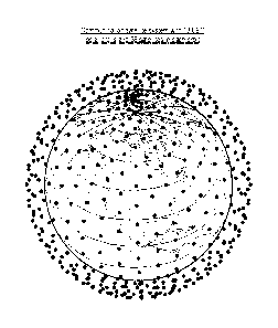
systems based on LEO orbits. FIG. 9 depicts a system with eighteen LEO polar
orbits and
thirty-six satellites in each orbit, for a total of 648 satellites. The
eighteen orbital planes are
evenly spaced at increments of 100. Embodiments of the present invention are
based on the
fact that the position on the surface of the Earth of a satellite's coverage
area can be changed,
within a limited range, without changing the position and trajectory of the
satellite itself. In
particular, in FIG. 2, the satellite's coverage area 230 is shown centered
around the subsatellite
point, as is customarily done in the art. However, the coverage area could
easily be placed off
center by simply changing the orientation of the satellite.
[0027] A satellite's orientation is controlled by the satellite's attitude
control module,
which comprises hardware and software for controlling and adjusting the
orientation of the
satellite. For example, an attitude control module might comprise a set of
reaction wheels
whose rate of rotation determines the rate of rotation of the satellite's
body. The attitude
control module can cause the satellite to rotate without changing the
satellite's trajectory. In
particular, it can cause the satellite to rotate about an axis parallel to its
direction of motion
along the orbit. Such axis is known in the art as the "roll" axis (as opposed
to the "pitch" axis
and the "yaw" axis).
[0028] In the English language, the verb "rotate" and its inflected forms
("rotating",
"rotation", etc.) can be both transitive and intransitive. In this disclosure
and the appended
claims, both variants are used. For example, the verb is intransitive in "the
Earth rotates" but it
is a transitive verb in "the satellite is rotated by the attitude control
module". It will be clear
from context which variant is used at each occurrence.
[0029] When the satellite rotates, the orientation of the entire body of the
satellite
changes, including the orientation of the communication antennas, if they are
rigidly affixed to
the satellite's body. As a result of the rotation of the communication
antennas, the position of
the coverage area on the surface of the Earth will, in general, change. In
particular, if the
rotation is about the roll axis, the coverage area will move outside of the
coverage strip
8
CA 02993628 2018-01-23
WO 2017/017570 PCT/1B2016/054353
depicted in FIG. 6. As a result, due to the rotation, the shape of the actual
coverage strip will be
altered, compared to the nominal shape depicted in FIG. 6. An example of how
the shape
might be altered in depicted in FIG. 18.
[0030] The altered shape of the coverage strip causes the position of areas of
overlap
with other coverage strips to change. Communication-satellite systems in
accordance with
embodiments of the present invention control the extent and timing of
satellite rotations
adaptively, as the Earth rotates, so as to cause the areas of overlap to be at
designated
locations on the surface of the Earth where enhanced communication capacity is
desired.
Brief Description of the Drawings
[0031] FIG. 1 depicts a communication satellite in LEO polar orbit in the
prior art.
[0032] FIG. 2 illustrates the definitions of satellite coverage area and of
subsatellite
point in the prior art.
[0033] FIG. 3 illustrates how quasi-rectangular coverage areas can be
effective at
providing efficient coverage of the Earth's surface.
[0034] FIG. 4 illustrates the definition of satellite ground track in the
prior art.
[0035] FIG. 5 depicts how multiple co-orbiting satellites can provide
continuous
coverage of locations on the Earth's surface that lie near the satellites'
ground track in the prior
art.
[0036] FIG. 6 illustrates how the coverage areas of multiple co-orbiting
satellites
combine into a single coverage strip in the prior art.
[0037] FIG. 7 illustrates how multiple satellite orbits are used in
communication-satellite systems in the prior art to achieve universal
coverage.
[0038] FIG. 8 shows the geometric relationship between adjacent coverage
strips
associated with adjacent orbits in the prior art.
9
CA 02993628 2018-01-23
WO 2017/017570 PCT/1B2016/054353
[0039] FIG. 9 depicts a snapshot of a communication-satellite system that
might utilize
an embodiment of the present invention. The system has 648 satellites arranged
in 18 LEO
polar orbits in evenly-spaced orbital planes, each with 36 co-orbiting
satellites uniformly
distributed along the orbit. The satellites are depicted as black dots.
[0040] FIG. 10 depicts how the coverage strips of satellites in adjacent
orbits provide full
coverage without overlap at the Earth's Equator.
[0041] FIG. 11 depicts how the coverage strips of satellites in adjacent
orbits have a
small extent of overlap at a latitude of 300
.
[0042] FIG. 12 depicts how the extent of coverage-strip overlap can be
increased by
rotating satellites about their roll axis. In this disclosure, "tilt" is used
as a synonym for "rotate"
[0043] FIG. 13 depicts how the increase in extent of coverage-strip overlap is
limited by
the maximum allowable satellite rotation (tilt).
[0044] FIG. 14 depicts how the extent of coverage-strip overlap is larger at
latitudes
further away from the Equator.
[0045] FIG. 15 depicts how it is possible to rotate satellites in multiple
adjacent orbits to
avoid coverage gaps.
[0046] FIGS. 16a through 16e depict a sequence of different combinations of
satellite
rotations that can be implemented to guarantee that a designated location on
the surface of
the Earth remains in an area of coverage-strip overlap at all times as the
Earth rotates. In these
figures, the designated location is of small extent.
[0047] FIGS. 17a through 17f depict a sequence of different combinations of
satellite
rotations that can be implemented to guarantee that a designated location on
the surface of
the Earth remains in an area of coverage-strip overlap at all times as the
Earth rotates. In these
figures, the designated location is of large extent.
[0048] FIG. 18 depicts the geometric shape of a coverage strip that has been
altered by
implementing satellite rotations at certain points in the satellites' orbit.
CA 02993628 2018-01-23
WO 2017/017570 PCT/1B2016/054353
Detailed Description
[0049] Embodiments of the present invention make it possible to designate
certain
locations on the surface of the Earth where it is desirable to have enhanced
communication
capacity. For some designated locations, it might be desirable to have
enhanced capacity at all
times; for others, it might be desirable to have enhanced capacity at certain
times of day or on
demand, for example, on the occasion of special events or occurrences.
[0050] In general, embodiments of the present invention can guarantee that a
designated location will have double coverage over a predesignated interval of
time. Such
interval of time might be, for example a particular portion of the day that is
repeated every day,
or every business day, or any selection of days and times that is convenient
to a particular end
user at the designated location. Some end users might want the presdesignated
interval of
time to be a full 24 hours every single day for uninterrupted double coverage
at all times.
[0051] Communication-satellite systems are particularly advantageous for
providing
communication services to locations where terrestrial communication systems
are unavailable
or difficult to access. A single communication satellite might have, for
example, ten to twenty
communication antennas, and each antenna might provide as much as several
hundred Mbit/s
of communication capacity. However, places on Earth where capacity is needed
tend to be
clustered together. For example, a small town in a remote area might benefit
from
communication access via satellite, but the small town is likely to be small
enough to fit entirely
within a single antenna beam. In such a situation, the total capacity
available to such a small
town is limited by the capacity of a single satellite antenna, if only one
satellite is available.
[0052] A particularly notable example of this problem is provided by cruise
ships on the
high seas, for which satellites are the only practical means to communicate
with the rest of the
world. A modern cruise ship might have as many as six thousand passengers and
more than
two thousand crew members. If the capacity available to such a cruise ship is
limited to the few
hundred Mbit/s provided by a single satellite antenna, each person on board
the ship has
access to just a few tens of kbit/s, on average. Clearly, it would be of great
benefit to double
the capacity available to such a cruise ship.
11
CA 02993628 2018-01-23
WO 2017/017570 PCT/1B2016/054353
[0053] Prior-art communication-satellite systems are typically structured to
guarantee
that every place on Earth is always within view of at least one satellite, so
that connectivity for
end users can be guaranteed to be available at all times. As discussed in the
Background
section, this means that many places on Earth will actually be within view of
two or more
satellites at any given time. Some places, especially near the poles, will
enjoy such double
coverage at all times. But, usually, those places are not where demand for
enhanced capacity
exists. Such demand is more likely to exist at mid latitudes, where a large
portion of the human
population lives.
[0054] It is clear from FIG. 8 that, at mid latitudes, there are substantial
portions of the
Earth's surface that enjoy double coverage at any given time, in prior-art
systems. But prior-art
systems cannot control when and where the double coverage is available. As a
result, at any
given time, there is a lot of double coverage available in areas where it is
not needed; and areas
where it is needed cannot be guaranteed to have it when they need it. In
contrast, with
embodiments of the present invention, it is possible to transfer double
coverage from areas
where it is available, but not needed, to areas where it is needed. All the
while continuing to
guarantee connectivity, with at least single coverage, everywhere.
[0055] FIG. 10 is a diagram of satellite coverage at the Earth's Equator. The
curved
line 110 represents the surface of the Earth at the Equator as might be viewed
for a position
high above the North Pole. From this viewpoint, LEO polar orbits, such as
those shown in
FIG. 7, are lines that come out of the plane of the figure. FIG. 10 also shows
seven LEO
satellites 1040 in adjacent polar orbits. The satellites are depicted as black
dots.
[0056] To avoid visual clutter in the figure, each satellite is depicted as
having a single
communication antenna. The corresponding antenna beams are depicted as antenna
beams 220-1 through 220-7. Each antenna beam is shown to span the width of a
corresponding
coverage strip. There are seven coverage strips 647-1 through 647-7. As
explained in
conjunction with FIG. 8, the coverage strips provide full coverage without any
overlap at the
Equator, as is depicted in FIG. 10.
12
CA 02993628 2018-01-23
WO 2017/017570 PCT/1B2016/054353
[0057] FIG. 11 is a diagram of satellite coverage at latitudes away from the
Equator, but
not as far as mid latitudes. The diagram of FIG. 11 is for a latitude of 30 .
The diagram is valid
for both a northern and a southern latitude of 30 . At such latitudes, there
is some overlap
between adjacent coverage strips, shown in the figure as overlap 1110, but the
extent of the
overlap is small. It is only about 12% at these latitudes. With such a small
overlap it is difficult,
(although not impossible) to implement embodiments of the present invention to
transfer the
double capacity available in the area of overlap from one place on Earth to
another. Details are
illustrated in the next few figures.
[0058] FIG. 12 illustrates a basic element of the techniques employed by
embodiments
of the present invention: satellite rotation, or "tilting". In this
disclosure, the verb "tilt" is used
as a shorter synonym of the verb "rotate". The shorter word is helpful in
making the figures
less cluttered and easier to understand. FIG. 12 depicts satellite 1245 as
having rotated (tilted)
about its roll axis so as to move its coverage area toward the west, i.e.,
toward satellite 1240,
which is not tilted. The rotation of satellite 1245 has been accomplished via
the satellite's
attitude control module, which has rotated the satellite by the angle shown in
FIG. 12 as tilt
angle 1230.
[0059] In the figure, the vertical direction for satellite 1220 is shown by
the dotted line
vertical 1220, while the dashed line 1221 shows the axis of symmetry of the
antenna beam.
The point where the vertical 1220 meets the surface of the Earth is the
subsatellite point, while
the point where the dashed line 1221 meets the surface of the Earth is the
approximate center
of the coverage area of satellite 1245. The two lines coincide for an untilted
satellite, and, for a
tilted satellite, the angle between the two lines is the angle by which the
satellite has been
tilted, compared to the nominal satellite orientation.
[0060] The diagram of FIG. 12 shows that satellite tilting increases the
extent of overlap
between the coverage area of satellite 1245 and the coverage area of satellite
1240. The
increase comes at the cost of a decrease in the extent of overlap with the
adjacent coverage
strip on the other side of satellite 1245 (not shown in FIG. 12). In this
sense, satellite tilting can
13
CA 02993628 2018-01-23
WO 2017/017570 PCT/1B2016/054353
be viewed as a technique for transferring overlap, and the associated double
capacity, from one
location to another.
[0061] FIG. 13 illustrates a limit to how much overlap can be transferred via
satellite
tilting. The angle by which a satellite can be tilted is not unlimited, for a
variety of reasons. For
example, there might be a lower limit to the allowable elevation of a
satellite above the
horizon, as seen by an Earth terminal. A consequence of such an elevation
limit is a limit on
satellite tilting because, if a satellite is tilted too much, Earth terminals
near the edge of the
coverage area might see the satellite too low above the horizon. Also,
distance between an
Earth terminal and the satellite might be required to be be no larger than a
maximum allowable
value, which also results in a tilt limit. For these and other reasons, there
will be a maximum
allowable tilt angle in many embodiments of the invention.
[0062] The diagram of FIG. 13 shows what happens when a satellite is tilted by
the
maximum amount. Satellite 1345 is at maximum tilt, having tilted by maximum
tilt angle 1330.
The extent of increased overlap 1310 is at its maximum possible value, for
this latitude.
Unfortunately, in the illustrative diagram of FIG. 13, this is not enough for
the edge of the tilted
coverage area of satellite 1345 to reach the center line of the adjacent
coverage strip, whose
position is indicated in the figure by an arrow. The arrow is labeled "ground
track 1347 of
satellite 1240" because that ground track is the center line of the adjacent
coverage strip, as
illustrated in FIG. 6.
[0063] There is an important consequence to the fact that the maximum reach of
the
coverage area of tilted satellite 1345 does not go as far as the arrow in FIG.
13: a place on Earth
that happens to be at that arrow's position won't be able have double
capacity. Therefore, at
these latitudes, embodiments of the present invention cannot unconditionally
guarantee
double capacity to a designated location because, as the Earth rotates, that
location might, at
some point, be on the center line of a coverage strip and no satellites in
adjacent orbits wil be
able to tilt sufficiently far to reach it. To enable such unconditionally
guaranteed double
capacity, maximum tilt angle can, for example, be increased, or the width of
coverage strips can
be increased to the point where, even at the Equator, there is some overlap
between adjacent
14
CA 02993628 2018-01-23
WO 2017/017570 PCT/1B2016/054353
coverage strips. It will be clear to those skilled in the art, after reading
this disclosure, when
and how much to increase the width of coverage strips or the maximum tilt
angle in order to be
able to implement embodiments of the present invention at a desired latitude.
[0064] FIG. 14 illustrates how satellite tilting becomes effective, at higher
latitudes, for
transferring double capacity unconditionally to any location. The diagram of
FIG. 14 is for a
latitude of 40 , north or south of the Equator. At these latitudes, the
overlap between adjacent
coverage strips is about 23% and, in the depiction of FIG. 14, the maximum
allowed tilt angle is
large enough that any designated place on Earth can be unconditionally
provided double
capacity via satellite tilting. This is illustrated in FIG. 14 by satellite
1345, which is tilted at the
maximum allowed tilt angle 1330. The edge of its coverage area reaches as far
as the ground
track 1347 of satellite 1240, denoted by the arrow. With this tilt angle, a
place at the arrow will
enjoy double capacity. For places that are closer to satellite 1345 than the
arrow, a lesser tilt
angle will be sufficient to provide them with double capacity.
[0065] The figure shows, however, that a gap 1450 in satellite coverage
appears
between satellite 1345 and the adjacent coverage strip on the side opposite
the arrow. That
can be dealt with by tilting an additional satellite, as shown in the next
figure.
[0066] FIG. 15 shows how the gap 1450 can be eliminated via progressive
tilting of
adjacent satellites. In the figure, satellite 1545 is tilted by an angle less
than the maximum
allowed. The angle is just enough that the gap 1450 becomes covered by the
coverage area of
satellite 1545 without an additional gap appearing elsewhere. However, it will
be clear to those
skilled in the art, after reading this disclosure, how to progressively tilt
additional satellites, if
necessary, to cover other gaps that might appear.
[0067] FIGS. 16a through 16e depict a sequence of different combinations of
satellite
tilts that can be implemented to guarantee that a designated location 1600 on
the surface of
the Earth, at mid latitudes, enjoys double capacity at all times as the Earth
rotates. In these
figures, the designated location is small enough that it can be regarded as a
single place on
Earth whose position is indicated by the white arrow in the figures.
CA 02993628 2018-01-23
WO 2017/017570 PCT/1B2016/054353
[0068] The sequence begins with FIG. 16a, wherein the designated location is
on the
center line of the coverage strip of satellite 1240. The combination of
satellite tilts that
achieves double capacity for this position of the designated location is, of
course, the
combination that was already depicted in FIG. 15. In the subsequent figures,
as the Earth
rotates, the position of the designated location indicated by the white arrow
will move toward
the left, in the direction indicated by the black arrow Earth's rotation 1610.
[0069] In FIG. 16b, the designated location has moved by a couple of degrees
of
longitude. It is now closer to satellite 1245 and, as a result, satellite 1245
does not need to tilt
as much as before to provide the designated location with double capacity.
Also, the reduced
tilt of satellite 1245 means that it is no longer necessary to tilt satellite
1545 for the purpose of
covering a gap.
[0070] In FIG. 16c, the designated location has moved further and is now in
the area of
overlap that occurs between adjacent coverage strips, at these latitudes, even
without any
satellite tilting. No satellite tilting is needed to provide double capacity
to the designated
location in this figure.
[0071] In FIG. 16d, as the Earth keeps rotating, the designated location has
now reached
the point where satellite 1240 needs to be tilted in order to keep providing
double capacity to
the designated location. No other satellites need to be tilted yet. The
diagram of FIG. 16d looks
like a mirror image of the diagram of FIG. 16b.
[0072] In FIG. 16e, the designated location has reached the center line of the
coverage
strip of satellite 1245. The diagram of FIG. 16e looks like a mirror image of
the diagram of
FIG. 16a. Because the designated location is now on the center line of a
coverage strip, satellite
1240 must be tilted by the maximum angle, and satellite 1640 must also be
tilted to cover the
gap in coverage that would otherwise appear.
[0073] As the designated location keeps moving with the rotation of the Earth,
the
sequence of FIGS. 16a through 16e can now be repeated with the new starting
point on the
center line of the coverage strip of satellite 1245.
16
CA 02993628 2018-01-23
WO 2017/017570 PCT/1B2016/054353
[0074] FIGS. 16a through 16e are for a location on Earth that is small enough
to be
regarded as a single place, but, sometimes, it is desirable to provide double
capacity to a
location that has a wider extent, such as, for example, a very large city or a
small country.
[0075] FIGS. 17a through 17f depict a sequence of combinations of satellite
tilts for
guaranteeing double capacity at all times to a location whose extent is almost
as wide as a full
coverage strip. Of course, compared to the sequence of FIGS 16a through 16e,
more satellites
need to be tilted to guarantee double capacity to such a large location. In
the figures, the
extended location to be covered is depicted as a white rectangle 1700 that is
almost as wide as
a coverage strip.
[0076] The sequence begins with FIG. 17a, wherein the designated location is
centered
in the coverage strip of satellite 1240. To provide double capacity to the
entire width of the
designated location, satellites 1245 and 1746 on both sides need to be tilted.
Furthermore,
progressive tilting of the next two satellites 1545 and 1747 is also needed to
prevent the
appearance of coverage gaps.
[0077] In FIG. 17b, the designated location has moved by a couple of degrees
of
longitude. Satellites 1545, 1245, 1746, and 1747 need to retain their tilt
angles, but now even
satellite 1240 needs to start tilting, so that its coverage area follows
extended location 1700 as
the Earth turns.
[0078] In FIG. 17c, the tilt angle of satellite 1240 has reached the allowed
maximum and
cannot tilt any further. To continue providing double capacity to location
1700 as the Earth
keeps turning, some other satellite needs to start tilting. This is shown in
the next figure.
[0079] In FIG. 17d, satellite 1545 has now tilted by the maximum angle, so
that the edge
of its coverage area has reached the center line of the coverage strip below
satellite 1245, to
meet the edge of the coverage area of satellite 1240. This way, extended
location 1700 can
continue to enjoy double capacity. In the meantime, the western edge of
extended
location 1700 is still near the center line of the coverage strip below
satellite 1240, such that
satellite 1245 needs to remain at maximum tilt. However, satellite 1746 can
now reduce its tilt
17
CA 02993628 2018-01-23
WO 2017/017570 PCT/1B2016/054353
angle because it only needs to cover the gap that would otherwise appear if it
were to reduce
its tilt angle to zero. The diagram of FIG. 17d looks like a mirror image of
the diagram of
FIG. 17c.
[0080] In FIG. 17e, as the Earth keeps rotating, satellites 1745, 1545, 1240,
and 1746,
need to retain their tilt angles while satellite 1245 needs to keep changing
its tilt angle so that
its coverage area follows extended location 1700 as the Earth turns. The
diagram of FIG. 17e
looks like a mirror image of the diagram of FIG. 17b.
[0081] In FIG. 17f, the designated location 1700 is now centered in the
coverage strip of
satellite 1245. The diagram of FIG. 17f looks like a mirror image of the
diagram of FIG. 17a, and
the sequence is now complete. As the designated location keeps moving with the
rotation of
the Earth, the sequence of FIGS. 17a through 17f can now be repeated with the
new starting
point in the coverage strip of satellite 1245.
[0082] In the diagrams of FIGS. 16a through 16e and 17a through 17f, the same
satellite
designations are used in consecutive figures for clarity of explanation.
However, those skilled in
the art will note that, in the time it takes for the Earth to rotate as shown
in the sequence of
figures, different satellites will actually be present in the positions marked
by the black dots in
different diagrams. Repeated satellite designations in these figures should be
interpreted to
refer to satellites in the same orbits, as opposed to a literal interpretation
as referring to the
same physical satellites. For example, when the discussion of FIG. 17b states
that
"satellites 1545, 1245, 1746, and 1747 need to retain their tilt angle", the
statement should not
be interpreted to mean that some physical satellites should remain tilted at a
constant tilt angle
during the time interval spanned by FIGS. 17a and 17b. Rather, as satellites
in those four orbits
approach the latitude of 40 during that time interval, they need to start
rotating so as to have
the prescribed tilt angles shown in the diagram by the time they reach the
latitude of 40 . As
they leave the latitude of 40 , they can rotate back to their nominal
orientation or, perhaps,
start rotating to a new tilt angle that might be needed for supporting another
designated
location at a different latitude. The statement about satellites retaining
their tilt angles should
18
CA 02993628 2018-01-23
WO 2017/017570 PCT/1B2016/054353
be understood to mean that the prescribed tilt angles for satellites in those
orbits at that
latitude do not change over the time interval between the two figures.
[0083] FIG. 18 shows what happens as satellites in a particular orbit approach
a
particular latitude at a point where a particular tilt is needed. FIG. 18 is
derived from FIG. 6, but
continental outlines and gridlines are not depicted in this figure in order to
reduce visual
clutter. The direction of motion of the co-orbiting satellites is indicated by
arrow 1801. When
the attitude control module of a satellite needs to rotate the satellite, the
rotation cannot be
instantaneous. Therefore, the rotation needs to be started prior to the
satellite reaching the
range of latitudes where a particular tilt angle is needed.
[0084] In FIG. 18, the point where a satellite rotation starts is shown as
1810. The
rotation is complete when the satellite reaches 1820, and the tilt angle is
then retained through
the range of latitudes 1830. Thereafter, the satellite's attitude control
module implements a
rotation that is the reverse of the rotation started at 1810, such that,
between 1840 and 1850,
the satellite returns to its nominal orientation.
[0085] All the co-orbiting satellites perform the maneuvers described in the
previous
paragraph when they pass above locations 1810, 1820, 1840, and 1850. As a
result, the shape
of the actual coverage strip implemented by the co-orbiting satellites of FIG.
18 is different
form the nominal shape of a coverage strip depicted in FIG. 6. That nominal
shape is outlined in
FIG. 18 by dashed lines. The actual shape is shown by the vertical hatching.
In the previous
paragraphs and figures, references to a satellite's coverage strip always were
to the satellite's
nominal coverage strip; of course, the tilting maneuvers illustrated in the
paragraphs and
figures resulted in actual coverage strips different form nominal as
illustrated in FIG. 18.
[0086] The shape of an actual coverage strip evolves only slowly, as the Earth
rotates
and as the tilt angles needed at a particular latitude change as the
designated area moves. In
the meantime, the co-orbiting satellites that generate the coverage strip move
at a much faster
speed than the designated area. The shape of the coverage strip remains stable
because all the
satellites start rotating at the same point in the orbit; that is, when they
pass above
19
CA 02993628 2018-01-23
WO 2017/017570 PCT/1B2016/054353
location 1810, which can, therefore, be regarded as a "trigger" location that
triggers the start of
satellite rotations.
[0087] Although FIGS. 10 through 17f depict satellites in adjacent orbits as
crossing the
same latitudes at the same time, it will be clear to those skilled in the art,
after reading this
disclosure, that such synchronization of satellites is not required for the
successful
implementation of embodiments of the present invention. Indeed, for example,
in the satellite
system depicted in FIG. 9 satellites in adjacent orbits do not cross the same
latitudes at the
same times. The altered shape of the actual coverage strip depicted in FIG. 18
does not depend
on the timing of satellites 540 relative to satellites in adjacent orbits. It
will be clear to those
skilled in the art, after reading this disclosure, how to adjust the exact
values of the tilt angles
depicted in FIGS. 10 through 17f as needed to accommodate a particular
relative timing
between satellites in adjacent orbits.
[0088] It is to be understood that this disclosure teaches just one or more
examples of
one or more illustrative embodiments, and that many variations of the
invention can easily be
devised by those skilled in the art after reading this disclosure, and that
the scope of the
present invention is defined by the claims accompanying this disclosure.