Note: Descriptions are shown in the official language in which they were submitted.
CA 02994645 2018-02-02
1
DESCRIPTION
STEP DETECTION DEVICE AND STEP DETECTION METHOD
TECHNICAL FIELD
[0001]
The present invention relates to a step detection device and a step detection
method for detecting a step on a road surface.
BACKGROUND ART
[0002]
There has been known a roadside object detection apparatus which estimates
the structure of the road surface around a vehicle using a parallax image
captured by a
stereo camera and detects a step on the road surface formed by roadside
objects, such as
a curb, from the structure of the road surface (see Patent Literature 1). The
apparatus
in Patent Literature 1 scans the height of the road surface along a horizontal
scanning
line of an image, and detects a step if the height change amount of the road
surface is
larger than or equal to a threshold.
CITATION LIST
PA __ LENT LITERATURE
[0003]
Patent Literature 1: Japanese Patent Application Publication No. 2014-002608
SUMMARY OF INVENTION
TECHNICAL PROBLEM
[0004]
Because of the influence of errors included in the structure of the road
surface
estimated from an image of the stereo camera, as the angle formed by the
horizontal
scanning line relative to the tangent direction of a step decreases, the
gradient of the
height change of the road surface becomes smaller. Accordingly, when the angle
formed by the tangent of the step and the horizontal scanning line is small,
the detection
accuracy of the step position is low.
[0005]
The present invention has been made in view of the above problem and an
2
object thereof is to provide a step detection device and a step detection
method which
are capable of detecting the position of a step on a road surface accurately.
SOLUTION TO PROBLEM
[0006]
A step detection device according to a first aspect of the present invention
detects the distance and the direction to a road surface around a vehicle,
using a distance
sensor mounted on the vehicle, and sets a first step determination position
and a second
step determination position on the road surface. Then, the step detection
device
calculates the height changes of the road surfaces at the first step
determination position
and the second step determination position based on the distance and the
direction to the
road surface, and detects a step on the road surface based on one of the step
determination positions, the gradient of the height change of the road surface
the one
being larger.
[0007]
A step detection device according to a second aspect of the present invention
sets the first step determination position on the road surface and calculates
the height
change of the road surface at the first step determination position based on
the distance
and the direction to the road surface. If the gradient of the height change of
the road
surface at the first step determination position is larger than or equal to a
threshold, the
road surface height calculation circuit does not calculate the height change
of the road
surface at the second step determination position, and the step on the road
surface is
detected based on the height change of the road surface at the first step
determination
position.
According to another aspect of the present invention there is provided a step
detection device comprising:
a distance sensor which is mounted on a vehicle and detects a distance and a
direction to a road surface around the vehicle;
CA 2994645 2018-12-03
2a
a step determination position circuit which sets a first step determination
position on the road surface, the first step determination position being away
from the
distance sensor in a first predetermined direction by a first predetermined
distance and
extending in a direction orthogonal to the first predetermined direction, and
which sets a
second step determination position on the road surface, the second step
determination
position being away from the distance sensor in a second predetermined
direction
different from the first predetermined direction by a second predetermined
distance and
extending in a direction orthogonal to the second predetermined direction;
a road surface height calculation circuit which calculates a height change of
the
road surface at the first step determination position and a height change of
the road
surface at the second step determination position, based on the distance and
the
direction to the road surface detected by the distance sensor; and
a step detection circuit which selects one step determination position of the
first
step determination position and the second step determination position
according to a
gradient of the height change of the road surface, and which detects a step on
the road
surface based on the height change of the road surface at the one step
determination
position of the first step determination position and the second step
determination
position, the gradient of the height change of the road surface at the one
step
determination position being larger than a gradient of the height change of
the road
surface at the remaining step determination position of the first step
determination
position and the second step determination position.
According to another aspect of the present invention there is provided a step
detection method comprising:
detecting a distance and a direction to a road surface around a vehicle using
a
distance sensor mounted on the vehicle;
setting a first step determination position on the road surface, the first
step
determination position being away from the distance sensor in a first
predetermined
CA 2994645 2018-12-03
2b
direction by a first predetermined distance and extending in a direction
orthogonal to the
first predetermined direction;
setting a second step determination position on the road surface, the second
step determination position being away from the distance sensor in a second
predetermined direction different from the first predetermined direction by a
second
predetermined distance and extending in a direction orthogonal to the second
predetermined direction;
calculating a height change of the road surface at the first step
determination
position and a height change of the road surface at the second step
determination
position, based on the distance and the direction to the road surface detected
by the
distance sensor;
selecting one step determination position of the first step determination
position and the second step determination position according to a gradient of
the height
change of the road surface; and
detecting a step on the road surface based on the height change of the road
surface at the one step determination position of the first step determination
position and
the second step determination position, the gradient of the height change of
the road
surface at the one step determination position being larger than a gradient of
the height
change of the road surface at the remaining step determination position of the
first step
determination position and the second step determination position.
ADVANTAGEOUS EFFECTS OF INVENTION
[0008]
The present invention reduces the influence of errors included in the distance
and the direction to a road surface detected by a distance sensor, and thus
accurately
detects the position of a step on the road surface.
BRIEF DESCRIPTION OF DRAWINGS
[0009]
CA 2994645 2018-12-03
CA 02994645 2018-02-02
3
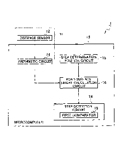
[Fig. 1] Fig. 1 is a block diagram illustrating the overall configuration of a
step
detection device 1 according to a first embodiment.
[Fig. 2] Fig. 2 is a perspective view illustrating an example of a first step
determination
position (Pai) and a second step determination position (Paz) which are in
linear shapes
and set on the road surface around a vehicle (Vc).
[Fig. 3] Fig. 3 is an overhead view corresponding to Fig. 2.
[Fig. 4] Fig. 4 is a graph illustrating a height change of a road surface at
the first step
determination position (Pai).
[Fig. 5] Fig. 5 is a graph illustrating a height change of a road surface at
the second step
determination position (Paz).
[Fig. 6] Fig. 6 is a flowchart illustrating an example of a step detection
method using the
step detection device 1 in Fig. 1.
[Fig. 7] Fig. 7 is a block diagram illustrating the overall configuration of a
step
detection device 2 according to a second embodiment.
[Fig. 8] Fig. 8 is a flowchart illustrating an example of a step detection
method using the
step detection device 2 in Fig. 7.
[Fig. 9] Fig. 9 is a block diagram illustrating the overall configuration of a
step
detection device 3 according to a third embodiment.
[Fig. 10] Fig. 10 is a perspective view illustrating an example of the linear
step
determination positions (Pal, Paz) and a step existing area Q1 which are set
on the road
surface around the vehicle (Vc).
[Fig. 11] Fig. 11 is an overhead view corresponding to Fig. 10.
[Fig. 12] Fig. 12 is a flowchart illustrating an example of a step detection
method using
the step detection device 3 in Fig. 9.
[Fig. 13] Fig. 13 is a block diagram illustrating the overall configuration of
a step
detection device 4 according to a fourth embodiment.
[Fig. 14] Fig. 14 is a perspective view illustrating operation of a step
existing area
estimation circuit 22 according to the fourth embodiment.
[Fig. 15] Fig. 15 is a flowchart illustrating an example of a step detection
method using
the step detection device 4 in Fig. 13.
CA 02994645 2018-02-02
4
[Fig. 16] Fig. 16 is a block diagram illustrating the overall configuration of
a step
detection device 5 according to a fifth embodiment.
[Fig. 17] Fig. 17 is a perspective view illustrating operation of a step
existing area
estimation circuit 23 according to the fifth embodiment.
[Fig. 18] Fig. 18 is a flowchart illustrating an example of a step detection
method using
the step detection device 5 in Fig. 16.
[Fig. 19] Fig. 19 is a block diagram illustrating the overall configuration of
a step
detection device 6 according to a sixth embodiment.
[Fig. 201 Fig. 20 is a flowchart illustrating an example of a step detection
method using
the step detection device 6 in Fig. 19.
[Fig. 21] Fig. 21(a) is a diagram illustrating a step detection method by a
road surface
height calculation circuit 16, and Fig. 21(b) is a diagram for explaining a
setting range
of a vicinity step determination position (ya).
[Fig. 22] Fig. 22 is a perspective view illustrating an example of a step
determination
position (Pat) in the case where a stereo camera is installed on a lateral
side of the
vehicle Vc.
[Fig. 23] Fig. 23 is an overhead view illustrating an example of a 360-degree
LRF in
which an LRF (12) is installed at the center of the roof of the vehicle Vc,
and the
emission range is set to be the entire circumference of the vehicle.
[Fig. 24] Fig. 24 is a flowchart illustrating an example of a step detection
method in the
case of using a laser rangefinder (LRF) as a distance sensor 12.
[Fig. 25] Fig. 25(a) is a cross-sectional view illustrating an example of a
low curbstone
block used in the road environment in Japan, and Fig. 25(b) is a cross-
sectional view
illustrating an example of a high curbstone block for defining a boundary
between a
sidewalk and a roadway.
DESCRIPTION OF EMBODIMENTS
[0010]
[First Embodiment]
Next, embodiments will be described with reference to the drawings.
[0011]
CA 02994645 2018-02-02
The overall configuration of a step detection device 1 according to a first
embodiment will be described with reference to Fig. 1. The step detection
device
detects the distance and the direction to the surfaces of objects (hereinafter
referred to as
"a road surface") including a road and a curb on the road around a vehicle and
detects a
step on the road surface based on height change of the road surface at
multiple step
determination positions which are in a linear shape in the vehicle width
direction and set
on the road surface.
[0012]
Specifically, the step detection device 1 includes a distance sensor 12 for
detecting the distance and the direction to a road surface around the vehicle
and a
microcomputer 13 for executing a series of information processing to detect a
step on
the road surface from distance measurement data including the distance and the
direction to the road surface detected by the distance sensor 12.
[0013]
An example of the distance sensor 12 is a stereo camera which shoots objects
around a vehicle from multiple different directions simultaneously and thus
can store
also information in the depth direction (distances from the sensor 12) of the
objects
around the vehicle. By performing certain image processing on the stereo
images
(including a parallax image) obtained by the stereo camera, it is possible to
acquire
three-dimensional information of an object image appearing on the stereo
images of an
object around the vehicle. The objects around the vehicle include a road and a
curb.
The details will be described later.
[0014]
The microcomputer 13 includes, for example, a general-purpose
microeontroller equipped with a CPU, memory, and input-output unit and serves
as
multiple information processing circuits included in the step detection device
1 by
executing a preinstalled computer program. The microcomputer 13 repeatedly
executes at predetermined time intervals, a series of information processing
cycles to
detect a step on the road surface from the distance and the direction to the
road surface
detected by the distance sensor 12. The microcomputer 13 may also be used as
an
CA 02994645 2018-02-02
6
electronic control unit (ECU) used for other control of the vehicle.
[0015]
The multiple information processing circuits which the microcomputer 13
serves as include an arithmetic circuit 14, a step determination position
circuit 15, a road
surface height calculation circuit 16, and a step detection circuit 18. The
step detection
circuit 18 includes a first comparator 19.
[0016]
The arithmetic circuit 14 constitutes a distance measurement unit 11 together
with the distance sensor 12, and performs, from stereo images obtained by the
stereo
camera, a series of stereo image processing to acquire three-dimensional
information of
object images appearing on the stereo images of objects around the vehicle.
[0017]
For example, the arithmetic circuit 14 performs lens distortion correction
processing for correcting distortion of stereo images caused by the lenses and
performs
parallelism correction processing for correcting the vertical position between
stereo
images (processing to make stereo images parallel and the same height). Then,
the
arithmetic circuit 14 performs stereo matching processing for estimating the
correspondence between the pixels of stereo images. This makes it possible to
calculate not only the two-dimensional coordinates of an object on the imaging
plane of
the stereo camera but also the distance from the imaging plane of the stereo
camera to
the object. Thus, it is possible to detect the distance and the direction to
an object
around the vehicle.
[0018]
The lens distortion correction processing, for example, captures a flat plate
with a black-and-white checkered pattern thereon with each camera and
estimates a lens
distortion parameter and a camera lens center parameter which allow the
lattice points
of the checkered pattern to be in a lattice shape constituted of rectangles.
Here, this
processing may be a common method for lens distortion correction, and the
present
embodiment has no particular limitation.
[0019]
CA 02994645 2018-02-02
7
The parallelism correction processing, for example, captures a flat plate with
a
black-and-white checkered pattern thereon with both cameras of a stereo camera
and
estimates a spatial position parameter and angle parameter between the stereo
cameras
which allow the positions of the lattice points of the checkered pattern on
the images of
both cameras to be at the same vertical positions. Here, this processing may
be a
common method for parallelism correction processing, and the present
embodiment has
no particular limitation.
[0020]
The stereo matching processing, for example, calculates which pixel in the
right camera image each pixel in the left camera image is associated, with
respect to the
left camera image. For example, the stereo matching processing calculates the
absolute values of the luminance value of each pixel in the left camera image
and the
luminance value of each pixel in the right camera image, as evaluation values,
and
calculates a pixel in the right camera image, of which the evaluation value is
minimum,
as the associated pixel. Methods of calculating the evaluation value include,
for
example, a method using the sum of absolute differences (SAD) or the sum of
squared
differences (SSD), or a method in which the evaluation calculation area
includes not
only a single point of each pixel but peripheral pixels of each pixel. Here,
the method
for calculating evaluation values may also be another common method, and the
present
embodiment has no particular limitation.
[0021]
The step determination position circuit 15 sets a linear step determination
position in the vehicle width direction on the road surface around the vehicle
on the
coordinates of the distance measurement data detected by the distance sensor
12. For
example, as illustrated in Figs. 2 and 3, the step determination position
circuit 15 sets a
first step determination position (Pai), which is away from the distance
sensor 12 in a
first predetermined direction (Dai) by a first predetermined distance and
extends in a
direction orthogonal to the first predetermined direction (Dai), on the road
surface on
the coordinates of the distance measurement data. Figs. 2 and 3 illustrate an
example
in which the distance sensor 12 is installed in the front of a vehicle (Vc),
and the first
CA 02994645 2018-02-02
8
predetermined direction (Dai) is set to be the traveling direction of the
vehicle (Vc).
Hence, the first step determination position (Pai) extending in parallel with
the vehicle
width direction is set on the coordinates of the distance measurement data,
being away
from the vehicle (Vc) in the front direction by the first predetermined
distance.
[0022]
The step determination position circuit 15 further sets a second step
determination position (Pa2), which is away from the distance sensor 12 in a
second
predetermined direction (Da2) by a second predetermined distance and extends
in a
direction orthogonal to the second predetermined direction (Da2), on the road
surface on
the coordinates of the distance measurement data. The second predetermined
direction
(Da2) is different from the first predetermined direction. Specifically, both
the first
predetermined direction (Dal) and the second predetermined direction (Da2) are
set in a
horizontal plane. The first predetermined direction (Dal) is not in parallel
with the
second predetermined direction (Da2), and the angle formed by the two
directions is an
angle except 0 degrees and 180 degrees.
[0023]
Note that, as described later, the first predetermined distance and the second
predetermined distance can be adjusted as appropriate such that the first step
determination position (Pal) and the second step determination position (Pa2)
intersect
each other in a step existing area. In addition, the first step determination
position
(Pai) and the second step determination position (Pa2) are set on the stereo
images
within the image capturing area of the stereo camera. The first predetermined
direction (Dal) is not limited to the traveling direction of the vehicle (Vc).
Further,
multiple step determination positions which are in directions different from
the first
predetermined direction (Dai) and the second predetermined direction (Da2) may
be
additionally set to determine a step.
[0024]
In an example illustrated in Figs. 2 and 3, a step (LD) having a steep change
in
the height of the road surface is formed at a road shoulder which is an end in
the vehicle
width direction of the roadway where the vehicle (Vc) can travel. Outside the
roadway
CA 02994645 2018-02-02
9
with the step (LD) as a boundary is provided a stepped portion (for example, a
sidewalk
or a road shoulder) the road surface of which is one step higher than the
roadway. As
described above, in the example illustrated in Figs. 2 and 3, the road
includes the
roadway and the stepped portion (sidewalk or road shoulder), and between the
roadway
and the stepped portion (sidewalk or road shoulder) is formed the step (LD).
The
linear first step determination position (Pal) and second step determination
position
(Pa2) extend in directions in which they cross the roadway, step (LD), and
stepped
portion (sidewalk or road shoulder).
[0025]
Note that the positional relationship between the foregoing distance sensor 12
and the step determination positions (Pal, Pa2) is a mere example. Another
example
will be described later with reference to Fig. 22.
[0026]
The road surface height calculation circuit 16 calculates each of the changes
of
the height data at the measurement points of the road surfaces at the first
step
determination position (Pal) and the second step determination position (Paz),
based on
the distances and the directions to the road surfaces detected by the distance
measurement unit 11.
[0027]
Specifically, the road surface height calculation circuit 16 performs
coordinate
conversion processing on the distance and the direction to the road surface to
acquire
three-dimensional information on the objects (including the road and the curb)
around
the vehicle on the coordinates of the distance measurement data. The
three-dimensional information on the objects around the vehicle includes
three-dimensional information on the road surface (including the surfaces of
the road
and the curb) around the vehicle. Thus, the road surface height calculation
circuit 16
can acquire the height of the road surface around the vehicle.
[0028]
The road surface height calculation circuit 16 calculates height change of the
road surface (distance measurement data) at each of the step determination
positions
CA 02994645 2018-02-02
(Pai, Pa2) from the height of the road surface. Fig. 4 is a graph illustrating
a height
change of the road surface at the first step determination position (Pai), and
Fig. 5 is a
graph illustrating a height change of the road surface at the second step
determination
position (Pa2). The vertical axes of Figs. 4 and 5 represent the height of the
road
surface, and the horizontal axes represent the step determination positions
(Pai, Pa2)
extending in the vehicle width direction.
[0029]
As illustrated in Figs. 4 and 5, the step (LD) is formed between a roadway
(Rr)
and a stepped portion (Rd). Specifically, the road surfaces of the roadway
(Rr) and the
stepped portion (Rd) have different heights and are connected by a road
surface height
changing portion (HC) at which the height of the road surface changes. The
connecting portion of the road surface height changing portion (HC) and the
roadway
(Rr) is defined as "a step endpoint LD". The step includes the road surface
height
changing portion (HC) and the step endpoint LD. The step endpoint LD has a
meaning of indicating a boundary of the roadway in the vehicle width direction
where
the vehicle can travel.
[0030]
As illustrated in Fig. 5, if the gradient of the height change of the road
surface
at the road surface height changing portion (HC) is steep, it is possible to
identify the
position of the step endpoint LD accurately. However, as illustrated in Fig.
4, if the
gradient of the height change of the road surface at the road surface height
changing
portion (I-IC) is gentle, it is difficult to identify the position of the step
endpoint LD
accurately. In other words, the steeper the gradient of the height change of
the road
surface at the road surface height changing portion (HC) is, the more
accurately the
position of the step endpoint LD can be identified.
[0031]
Since the gradient of the height change of the road surface at the road
surface
height changing portion (HC) is determined using the cross-section at the step
determination position (Pai, Pa2) on the coordinates of the distance
measurement data
detected by the distance sensor 12, which is directed obliquely downward from
the
CA 02994645 2018-02-02
111
vehicle to the road surface, the gradient changes depending on the angle
formed by the
tangent of the step endpoint LD and the step determination position (Pai,
Pa2), as
illustrated in Fig. 3. Specifically, at the intersection point of the step
determination
position (Pai, Paz) and the step endpoint LD, the closer to a right angle the
angle formed
by the tangent of the step endpoint LD and the step determination position
(Pal, Pa2) is,
the steeper the gradient of the height change of the road surface at the road
surface
height changing portion (HC) is. In contrast, the smaller the angle formed by
the
tangent of the step endpoint LD and the step determination position (Pal, Paz)
is, the
more the cross-section taken by the step determination position (Pal, Pa2) on
the
coordinates of the distance measurement data is inclined. Consequently, the
gradient
of the height change of the road surface at the road surface height changing
portion
(HC) is gentler. Thus, at the intersection point of the step determination
position (Pal,
Paz) and the step endpoint LD, the closer to a right angle the angle formed by
the
tangent of the step endpoint LD and the step determination position (Pai, Pa2)
is, the
more accurately the position of the step endpoint LD can be identified.
[0032]
In view of the above, the step detection circuit 18 detects the step on the
road
surface based on one of the first step determination position (Pai) and the
second step
determination position (Paz), the gradient of the height change of the road
surface at
which is larger than that at the other.
[0033]
Specifically, the step detection circuit 18 includes the first comparator 19
for
comparing the gradients of the height changes of the road surfaces at the
first step
determination position (Pai) and the second step determination position (Pa2).
For
example, the first comparator 19 compares height change rates of the road
surfaces at
the step determination positions. The first comparator 19 may compare the
average
values of the height change rates at the road surface height changing portions
(HC), or
compare the height change rates only in the vicinities of the step endpoints
LD.
[0034]
The step detection circuit 18 selects a step determination position (Fig. 5)
at
CA 02994645 2018-02-02
12
which the height change rate is large, in other words, at which the gradient
of the height
change of the road surface is steep, and detects the position of the step
endpoint LD at
the boundary between the road surface height changing portion (HC) and the
roadway
(Rr) illustrated in Fig. 5. The method of detecting the position of the step
endpoint LD
is not particularly limited, but a known method may be used.
[0035]
For example, the vicinity of the boundary between the road surface height
changing portion (HC) and the roadway (Rr) is divided into multiple small
sections.
Then, the height change rate of each section is calculated. If the height
changes in
adjacent sections are larger than or equal to a predetermined threshold, the
boundary
between the adjacent sections may be identified as the position of the step
endpoint LD.
[0036]
Meanwhile, the road surface of the roadway (Rr) has a gradient (cant) such
that the height decreases from the center toward the road shoulders at both
ends.
Considering the gradient around the step, after the step detection circuit 18
determines
the existence of a step from the height change of the road surface at the
first step
determination position (Pal), the road surface height calculation circuit 16
may further
set a vicinity step determination position (ya) and extract the only distance
measurement data of a certain gradient portion in the vicinity of the step to
accurately
detect the position of the step endpoint LD. Hereinafter, a specific method
will be
described.
[0037]
First, the road surface height calculation circuit 16 detects a position, at
which
a height change larger than or equal to a predetermined height determination
value has
occurred, from the height change of the road surface at the first step
determination
position (Pai) (Fig. 4). Specifically, as illustrated in Fig. 21(a), the road
surface height
calculation circuit 16 estimates the height (HE) of the road surface of the
roadway, and
then, the step detection circuit 18 determines that a step exists if a height
change larger
than or equal to a height determination value (hp) occurs relative to the road
surface
height (HE) of the roadway.
CA 02994645 2018-02-02
13
[0038]
Specifically, assuming that in the front direction of the distance sensor 12
exists a road surface area of the roadway, the center position (Cvc) of the
distance
sensor 12 is calculated from the distance measurement data of the first step
determination position (Pal). Then, an area within a predetermined range from
the
center position (Cvc) of the distance sensor 12 is extracted as a distance
sensor center
area (GI). Next, the height (HE) of the road surface in the distance sensor
center area
(G1) is estimated. The height direction of the distance sensor center area
(GI) is
discretely divided into sections, and the number of the distance measurement
data of the
distance sensor center area (GO existing in each section is counted. The
height of the
section in which the number of counts is largest is regarded as the height
(HE) of the
roadway. Besides, also Hough transformation can be used to estimate the road
surface
height of the roadway.
[0039]
Here, the center position (Cvc) of the distance sensor 12 is the optimum
position in the case where the distance sensor 12 is installed at a front
portion of the
vehicle Vc in the traveling direction. The center position (Cvc) of the
distance sensor
12 varies depending on the installation position of the distance sensor 12 on
the vehicle
Vc. Hence, a position considered to be most likely to be a road surface
relative to the
vehicle Vc can be set as an area for estimating the road surface height (HE)
of the
roadway.
[0040]
As illustrated in Fig. 21(a), if one of the measurement data exists at a
position
(TD) higher than the road surface height (HE) of the roadway by the amount
larger than
or equal to the height determination value (hp), the road surface height
calculation
circuit 16 determines that a step exists there. In addition to this, it is
also possible to
calculate local height changes continuing in the vehicle width direction and
determine
that a step exists if the height change is larger than or equal to a
predetermined value.
[0041]
Next, the road surface height calculation circuit 16 sets the vicinity step
14
determination position by further limiting the range of the first step
determination
position (Pal) in the height direction and the vehicle width direction.
Specifically, as
illustrated in Fig. 21(b), the road surface height calculation circuit 16
sets, with respect
to the height changing position (To), a predetermined height (xa) downward in
terms of
the height direction and a predetermined distance (ya) toward the roadway in
terms of
the vehicle width direction to set the vicinity step determination position
(ya). This
makes it possible to extract the only distance measurement data of a certain
gradient
portion in the vicinity of the step, and thus to detect the position of the
step endpoint LD
accurately, even if the road surface of the roadway (Rr) has a gradient (cant)
in which
the height decreases from the center toward the road shoulders at both ends.
[0042]
With reference to Fig. 6, descriptions will be provided for an example of a
step
detection method using the step detection device 1 in Fig. 1. A series of
processing
operations shown in Fig. 6 is repeatedly executed in predetermined time
cycles. First,
at step S01, stereo images are acquired using a stereo camera which is an
example of the
distance sensor 12.
[0043]
The process proceeds to step S03, where the arithmetic circuit 14 performs
lens
distortion correction processing for correcting distortion of the stereo
images caused by
the lenses and parallelism correction processing for correcting the vertical
position
between stereo images. The process proceeds to step S05, where the arithmetic
circuit
14 performs stereo matching processing for estimating the correspondence
between the
pixels of the stereo images. Then, the arithmetic circuit 14 detects the
distances and
the directions to objects around the vehicle.
[0044]
The process proceeds to step S07, where the step determination position
circuit
15 sets the linear first step determination position (Pal) extending in the
vehicle width
direction on the road surface around the vehicle, as illustrated in Figs. 2
and 3. Then,
the process proceeds to step S09, where the step determination position
circuit 15
calculates the height change of the road surface at the first step
determination position
CA 2994645 2018-12-03
15
(Pai) (a first height change) based on the distances and directions to the
objects acquired
by the arithmetic circuit 14 as illustrated in Fig. 4.
[0045]
The process proceeds to step S11, where step determination position circuit 15
sets the second step determination position (Paz), which is different from the
first step
determination position (Pal), on the road surface around the vehicle as
illustrated in Figs.
2 and 3. Then, the process proceeds to step S13, where the step determination
position
circuit 15 calculates the height change of the road surface at the second step
determination position (Paz) (second height change) based on the distances and
the
directions to the objects acquired by the arithmetic circuit 14 as illustrated
in Fig. 5.
[0046]
The process proceeds to step S15, where the first comparator 19 compares the
gradients of the height changes of the road surfaces at the first step
determination
position (Pai) and the second step determination position (Paz). Then, the
process
proceeds to step S17, where the step detection circuit 18 selects a step
determination
position (Fig. 5) at which the height change is large, in other words, at
which the
gradient of the height change of the road surface is steep, and detects the
position of the
step endpoint LD at the boundary between the road surface height changing
portion
(HC) and the roadway (Rr).
[0047]
As described above, the first embodiment provides the following operation and
effect.
[0048]
Since errors are included in the distance and the direction to the road
surface
detected by the distance sensor 12, if the angle formed by the tangent of the
step (LD)
and the step determination position is small, the accuracy in detecting the
position of the
step (LD) decreases due to the influence of the errors. In light of this, the
two step
determination positions (Pal, Paz), of which the angles formed with the
tangent of the
step (LD) are different from each other, are set. Then, the step on the road
surface is
detected based on one of the first step determination position (Pal) and the
second step
CA 2994645 2018-12-03
CA 02994645 2018-02-02
16
determination position (Pa2), the gradient of the height change of the road
surface at
which is larger than that of the other (Fig. 5). This reduces the influence of
the errors
included in the distance and the direction to the road surface detected by the
distance
sensor 12 and makes it possible to detect the position of the step (LD) on the
road
surface accurately. In particular, it is possible to detect the position of a
step endpoint
LD more accurately at a curve or an intersection where the angle formed by a
step
tangent direction and a step determination position is small.
[0049]
[Second Embodiment]
With reference to Fig. 7, descriptions will be provided for the overall
configuration of a step detection device 2 according to a second embodiment.
If the
gradient of the height change of the road surface at the first step
determination position
(Pai) is larger than or equal to a threshold, the step detection device 2
detects the step
(LD) on the road surface based on the height change of the road surface at the
first step
determination position (Pai). Further, in this case, to reduce the calculation
load and
improve the processing speed while keeping the step detection accuracy, the
step
detection device 2 does not set the second step determination position (Pa2)
and does
not calculate the height change of the road surface at the second step
determination
position.
[0050]
Specifically, the road surface height calculation circuit 16 includes a second
comparator 20 for comparing the gradient of the height change of the road
surface at the
first step determination position (Pal) with a threshold. The other
configurations are
the same as those in the step detection device I in Fig. 1, and descriptions
thereof will
be omitted.
[0051]
The second comparator 20 compares a predetermined threshold and the
gradient of the height change of the road surface at the first step
determination position
(Pat). The method of the comparison is not particularly limited, but a known
method
may be used. For example, the second comparator 20 is capable of using the
height
CA 02994645 2018-02-02
17
change rate of the road surface at a step determination position for the
comparison.
The second comparator 20 may use the average value of the height change rate
at the
road surface height changing portion (HC) in Fig. 4 for the comparison, or may
use the
only height change rate in the vicinity of the step endpoint LD for the
comparison.
Note that the threshold can be set as appropriate in accordance with a
detection accuracy
required for the step detection device 2.
[0052]
With reference to Fig. 8, descriptions will be provided for an example of a
step
detection method using the step detection device 2 in Fig. 7. A series of
processing
operations illustrated in Fig. 8 is repeatedly executed in predetermined time
cycles.
Fig. 8 is different from Fig. 6 in that step S21 is executed between steps S09
and S11.
Processing executed at steps S01 to S17 in Fig. 8 is the same as in steps SO1
to S17 in
Fig. 6, and descriptions thereof will be omitted.
[0053]
At step S21, the second comparator 20 compares the gradient of the height
change of the road surface at the first step determination position (Pal) with
the
threshold. If the gradient of the height change of the road surface is larger
than or
equal to the threshold (YES at S21), it can be judged that the gradient of the
height
change of the road surface at the first step determination position (Pai) is
steep enough
to satisfy the detection accuracy required for the step detection device 2. In
this case,
the process proceeds to step S17 without executing steps S II to S15. In step
S17, the
step detection circuit 18 detects a step on the road surface based on the
height change of
the road surface at the first step determination position (Pal).
[0054]
On the other hand, if the gradient of the height change of the road surface is
smaller than the threshold (NO at step S21), it can be judged that the
gradient of the
height change of the road surface at the first step determination position
(Pai) is not
steep enough to satisfy the detection accuracy required for the step detection
device 2.
Hence, to satisfy the position detection accuracy, step Sll to S15 are
executed in the
same way as in the first embodiment before the process proceeds to step S17.
At step
CA 02994645 2018-02-02
18
S17, the step detection circuit 18 detects a step on the road surface based on
a step
determination position, the gradient of the height change of the road surface
at which is
larger.
[0055]
As described above, the second embodiment provides the following operation
and effect.
[0056]
If the gradient of the height change of the road surface at the first step
determination position (Pal) is larger than or equal to the threshold, the
step on the road
surface is detected based on the height change of the road surface at the
first step
determination position (Pal). This reduces the influence of errors included in
the
distance and the direction to the road surface detected by the distance sensor
12 and
makes it possible to detect the position of the step on the road surface
accurately. In
particular, it is possible to detect the position of the step endpoint LD more
accurately at
a curve or an intersection where the angle formed by a step tangent direction
and a step
determination position is small. In addition, the step determination position
circuit 15
does not set the second step determination position (Pa2), and the road
surface height
calculation circuit 16 does not calculate the height change of the road
surface at the
second step determination position (Pa2). Thus, it is possible to reduce the
calculation
load and improve the processing speed while keeping the step detection
accuracy.
[0057]
Note that in the example illustrated in the second embodiment, if the gradient
of the height change of the road surface is smaller than the threshold (NO at
S21), the
same processing as in the first embodiment is executed. However, the
embodiment is
not limited to this, but various modifications can be made. For example, if
the
gradient of the height change of the road surface is smaller than the
threshold (NO at
S21), the step detection device 2 can terminate this processing operation
cycle without
executing steps Sll to S17 and start the next processing cycle. Then, at step
S07 in
the next processing cycle, the step determination position circuit 15 can set
a first
predetermined direction and first predetermined distance which are different
from the
19
previous first predetermined direction and first predetermined distance. With
this
modification, too, it is possible to reduce the calculation load and improve
the
processing speed while keeping the step detection accuracy. In the example of
the
second embodiment, if the gradient of the height change of the road surface at
the first
step determination position (Pal) is larger than or equal to the threshold,
the step of the
road surface is detected based on the height change of the road surface at the
first step
determination position (Pal), and the height change of the road surface at the
second
step determination position (Paz) is not calculated. Other than this, it is
possible to
further set multiple step determination positions and repeat determination
processing in
order from the first step determination position (Pai) to a step determination
position
which enables the gradient of the height change of the road surface to be
larger than or
equal to the threshold. If the step determination position which enables the
gradient of
the height change of the road surface to be larger than or equal to the
threshold is found,
it is possible to detect a step on the road surface based on the height change
of the road
surface with the step determination position which enabled the gradient of the
height
change of the road surface to be larger than or equal to the threshold,
without executing
the next determination processing.
[0058]
[Third Embodiment]
If the intersection point of the first step determination position (Pai) and
the
step (LD) and the intersection point of the second step determination position
(Paz) and
the step (LD) are away from each other, it is difficult in some cases to
compare the
difference between the gradients of the height changes of the road surfaces
properly.
[0059]
In view of the above, in examples described in third to sixth embodiments,
a step existing area where a step exists at a first step determination
position (Pai)
is estimated, and then a second step determination position (Paz) passing
through
the step existing area is set. Specifically, step detection devices each
further
include a step existing area estimation circuit for estimating the step
existing
area where a step exists at the first step determination position (Pai). The
step
CA 2994645 2018-12-03
CA 02994645 2018-02-02
determination position circuit 15 sets a second predetermined direction and a
second
predetermined distance such that the second step determination position (Pa2)
passes
through the step existing area. This makes it possible to bring the step
detected at the
first step determination position (Pai) closer to the step detected at the
second step
determination position (Pa2).
[0060]
As illustrated in Fig. 9, the step detection device 3 according to the third
embodiment includes the step existing area estimation circuit 21 for
estimating a step
existing area Qi based on the height change of the road surface at the first
step
determination position (Pal). Other configurations are the same as those in
the step
detection device 1 in Fig. 1. Note that although descriptions will be provided
here for
the third embodiment based on the step detection device 1 in Fig. 1, the third
embodiment is applicable to the step detection device 2 in Fig. 7.
[0061]
As illustrated in Figs. 10 and 11, the step existing area estimation circuit
21
specifies an area including the road surface height changing portion (HC) and
the step
endpoint LD from the height change of the road surface at the first step
determination
position (Pai) (Fig. 4) and sets the area as the step existing area Qi. The
step
determination position circuit 15 sets the second predetermined direction and
the second
predetermined distance such that the second step determination position (Pa2)
passes
through the step existing area Qi.
[0062]
The depth range of the step existing area Qi can be, for example, the length
of
one curbstone. Search within the length of one curbstone makes it possible to
set the
second step determination position within a range in which the inclination of
the curb
does not change.
[0063]
The horizontal range of the step existing area Qi can be changed in accordance
with the amount of the height change. There is a standard of a one-piece block
in
which the gradient is set in a range of about 35 to 45 cm from the vicinity of
the step
CA 02994645 2018-02-02
21
because of drainage or the like, for a low curbstone block (symbol B1 in Fig.
25(a))
used in the road environment in Japan. Based on the standard for the one-piece
block,
the horizontal range can be set to about 50 cm considering the difference
between the
height changing position (TD) and the true step endpoint LD. Here, in a
country other
than Japan, the horizontal range may be set to a predetermined distance based
on
standards or the like in the country.
[0064]
In addition, a high curbstone block (symbol B2 in Fig. 25(b)) for defining a
boundary between a sidewalk and a roadway includes a curbstone alone without
including a gradient portion on the roadway side. Accordingly, a gradient
portion
around the step is made by the transverse gradient of the roadway. This means
that the
gradient is set in the distance from the entire roadway to the endpoint of the
curb. In
the road environment in Japan, even if the predetermined distance in the
vehicle width
direction is set to about 50 cm for a low curbstone block, the angle of the
gradient does
not change. Thus, it is possible to detect the position of the step endpoint
LD correctly.
Here, since the entire roadway has a constant gradient, the accuracy will be
better when
the entire roadway is included in the predetermined distance. This is because
that the
S/N ratio of distance measurement data is improved against noises. In light of
this, the
horizontal range can be changed in accordance with the height change which
means the
height of a curbstone block. This allows for extraction in a necessary and
minimum
range which has a constant gradient and makes it possible to estimate the road
surface
gradient more accurately. Consequently, the position of the step endpoint LD
can be
detected more accurately.
[0065]
An example of a step detection method using the step detection device 3 in
Fig.
9 will be described with reference to Fig. 12. A series of processing
operations
illustrated in Fig. 12 is repeatedly executed in predetermined time cycles.
Fig. 12 is
different from Fig. 6 in that step S31 is executed between steps S09 and S11.
The
processing executed at steps SO1 to S17 in Fig. 12 is the same as in steps SO1
to S17 in
Fig. 6, and descriptions thereof will be omitted.
22
[0066]
At step S31, the step existing area estimation circuit 21 estimate the step
existing area Q1, in which the step (LD) exists, from the height change of the
road
surface at the first step determination position (Pat) (Fig. 4). Then, the
process
proceeds to step S11, where the step determination position circuit 15 adjusts
the second
predetermined direction and the second predetermined distance to set the
second step
determination position (Paz) which passes through the step existing area Q.
[0067]
As described above, the third embodiment provides the following operation
and effect.
[0068]
The step existing area Qi where a step exists at the first step determination
position (Pal) is estimated, and the second step determination position (Paz)
passing
through the step existing area Qi is set. This makes it possible to bring the
step
detected at the first step determination position (Pat) closer to the step
detected at the
second step determination position (Paz). Accordingly, it is possible to
compare the
gradients of the height changes of the road surfaces at almost the same step
position.
This allows for a more suitable angle setting of the predetermined direction
relative to
the step (LD), which in turn allows for a more accurate detection of the
position of the
step (LD).
[0069]
Since the step existing area Qi is estimated based on the height change of the
road surface at the first step determination position (Pal) step, it is
possible to estimate
the step existing area Qi more accurately. As a result, it is possible to
bring the step at
the first step determination position (Pai) closer to the step at the second
step
determination position (Paz). Accordingly, it is possible to compare the
gradients of
the height changes of the road surfaces at almost the same step position. This
allows
for a more suitable angle setting of the predetermined direction relative to
the step (LD),
which in turn allows for a more accurate detection of the position of the step
(LD).
[0070]
CA 2994645 2018-12-03
CA 02994645 2018-02-02
23
[Fourth Embodiment]
The step detection device 4 according to the fourth embodiment repeatedly
executes a series of step detection processes in predetermined time cycles and
estimates
a step existing area Q2 based on the step position detected in the previous
processing
cycle.
[0071]
As illustrated in Fig. 13, the step detection device 4 according to the fourth
embodiment includes the step existing area estimation circuit 22 for
estimating the step
existing area Q2 based on the position of the step (LD) which was previously
detected.
The other configurations are the same as those in the step detection device 1
in Fig. 1.
Note that although descriptions will be provided here for the fourth
embodiment based
on the step detection device 1 in Fig. 1, the fourth embodiment is applicable
to the step
detection device 2 in Fig. 7.
[0072]
Specifically, the step existing area estimation circuit 22 estimates the
movement amount of the vehicle Ve in predetermined time cycles. The step
existing
area estimation circuit 22 estimates a position or an area where the step (LD)
is
expected to be detected this time, using the estimated movement amount and
positional
information on the previously detected step endpoint LD. In other words, the
step
existing area estimation circuit 22 estimates the step existing area Q2 from
the position
of the step endpoint LD which was detected at a different time. For example,
as
illustrated in Fig. 14, the previously detected position of the step endpoint
LD is
corrected by the movement amount of the vehicle. Of the corrected positions
(Fri, FT2,
FT3, F-rio), the
step existing area Q2 is set in an area including the position (En)
which is closest to the first step determination position (Pai). The step
existing area Q2
is set in an area in which the closest position (F-i-7) is centered.
Alternatively, the step
existing area Q2 may be set in an area in which an intersection point of a
line connecting
the corrected positions (Fri, FT2, FT3, FTIO) and the
first step determination position
(Pai) is centered. The step determination position circuit 15 adjusts the
second
predetermined direction and the second predetermined distance to set the
second step
24
determination position (Paz) which passes through the step existing area Q2.
[0073]
An example of a step detection method using the step detection device 4 in
Fig.
13 will be described with reference to Fig. 15. A series of processing
operations
illustrated in Fig. 15 is repeatedly executed in predetermined time cycles.
Fig. 15 is
different from Fig. 6 in that step S41 is executed between steps S09 and S11.
The
processing executed at steps SO1 to S17 in Fig. 15 is the same as in steps SO1
to S17 in
Fig. 6, and descriptions thereof will be omitted.
[0074]
At step S41, the step existing area estimation circuit 22 estimates the
movement amount of the vehicle Vc in predetermined time cycles. Then, the step
existing area estimation circuit 22 estimates the step existing area Q2, using
the
movement amount and positional information on the previously detected step
endpoint
LD. Then, the process proceeds to step Si!, where the step determination
position
circuit 15 adjusts the second predetermined direction and the second
predetermined
distance to set the second step determination position (Paz) which passes
through the
step existing area Qz.
[0075]
As described above, the fourth embodiment provides the following operation
and effect.
[0076]
Since the step existing area is estimated based on the previously detected
step
position, it is possible to estimate the step existing area Q2 more
accurately. As a
result, it is possible to bring the step at the first step determination
position (Pai) closer
to the step at the second step determination position (Paz). Accordingly, it
is possible
to compare the gradients of the height changes of the road surfaces at almost
the same
step position. This allows for a more suitable angle setting of the
predetermined
direction relative to the step (LD), which in turn allows for a more accurate
detection of
the position of the step (LD).
[0077]
CA 2994645 2018-12-03
CA 02994645 2018-02-02
[Fifth Embodiment]
The step detection device 5 according to the fifth embodiment sets multiple
first step determination positions (Pai) in one processing cycle and tries to
detect a step
on the road surface for every first step determination position (Pal). Then, a
step
existing area Q3 is estimated based on a step position which was successfully
detected.
[0078]
As illustrated in Fig. 16, the step detection device 5 according to the fifth
embodiment includes the step existing area estimation circuit 23. The step
determination position circuit 15 sets multiple first step determination
positions (Pai) in
one processing cycle. The step detection circuit 18 tries to detect a step on
the road
surface for every first step determination position (Pai), and the step
existing area
estimation circuit 23 estimates a step existing area Q3 based on the step (LD)
which was
successfully detected. The other configurations are the same as those in the
step
detection device 1 in Fig. 1. Note that although descriptions will be provided
here for
the fifth embodiment based on the step detection device 1 in Fig. 1, the fifth
embodiment is applicable to the step detection device 2 in Fig. 7.
[0079]
Specifically, as illustrated in Fig. 17, the step detection circuit 18 tries
to detect
a step on the road surface sequentially from a first step determination
position (Pai)
closer to the distance sensor 12 in one processing cycle. Then, of the step
positions
(Fsi, Fs2) at which the detection was succeeded, the step existing area
estimation circuit
23 selects the step position (Fs2) closest to the first step determination
position (Pal) at
which the detection was failed. Then, the step existing area estimation
circuit 23
estimates the step existing area Q3 at the first step determination position
(Pal) at which
the detection was failed, based on the selected step position (Fs2). The step
determination position circuit 15 adjusts the second predetermined direction
and the
second predetermined distance to set the second step determination position
(Pa2) which
passes through the step existing area Q3.
[0080]
Note that it is also possible to try to detect a step on the road surface
26
sequentially from a first step determination position (Pai) farthest from the
distance
sensor 12. Alternatively, the step existing area Q3 may be estimated using not
only the
closest step position but also additionally using the second closest position
(Fsl) and the
third closest step position and so on.
[0081]
An example of a step detection method using the step detection device 5 in
Fig.
16 will be described with reference to Fig. 18. A series of processing
operations
illustrated in Fig. 18 is repeatedly executed in predetermined time cycles.
Fig. 18 is
different from Fig. 6 in that step S51 is executed between steps S09 and S11.
In
addition, processing contents at steps S07 and S09 are different from those in
Fig. 6.
Processing executed at the other steps are the same as in Fig. 6, and
descriptions thereof
will be omitted.
[0082]
At step S07, the step determination position circuit 15 sets multiple first
step
determination positions (Pal) on the road surface around the vehicle. At this
time, the
step determination position circuit 15 simultaneously sets the multiple first
step
determination positions (Pal), not changing the first predetermined direction
but
changing the first predetermined distance.
[0083]
The process proceeds to step S09, where the step determination position
circuit
15 calculate the height change (first height change) of the road surface at
every first step
determination position (Pai) based on the distances and the directions to
objects
acquired by the arithmetic circuit 14. Further, the step detection circuit 18
tries to
detect a step for every first step determination position (Pal).
[0084]
The process proceeds to step S51, where the step existing area estimation
circuit 23 selects the step position (Fs2) closest to the first step
determination position
(Pal) out of the step positions (Fs 1, Fs2) which were successfully detected.
Then, the
step existing area estimation circuit 23 estimates the step existing area Q3
at the first
step determination position (Pai) based on the selected step position (Fs2).
CA 2994645 2018-12-03
27
[0085]
The process proceeds to step S11, where the step determination position
circuit
15 adjusts the second predetermined direction and the second predetermined
distance to
set the second step determination position (Pa2) which passes through the step
existing
area Q.
[0086]
As described above, the fifth embodiment provides the following operation and
effect.
[0087]
The multiple first step determination positions (Pal) are set, and the
detection
of a step on the road surface is attempted for every first step determination
position
(Pal). The step existing area Q3 is estimated based on the step positions
(Fsi, Fs2)
which were successfully detected. This allows for more accurate estimation of
the step
existing area. As a result, it is possible to bring the step at the first step
determination
position (Pal) closer to the step at the second step determination position
(Pa2).
Accordingly, it is possible to compare the gradients of the height changes of
the road
surfaces at almost the same position of the step. This allows for a more
suitable angle
setting of the predetermined direction relative to the step (LD), which in
turn allows for
a more accurate detection of the position of the step (LD).
[0088]
[Sixth Embodiment]
The step detection device 6 according to the sixth embodiment estimates the
position of the vehicle Vc on the map and estimates a step existing area based
on the
estimated position of the vehicle Vc on the map.
[0089]
As illustrated in Fig. 19, the step detection device 6 according to the sixth
embodiment further includes a map acquisition circuit 26 for acquiring map
information
on the surroundings of the vehicle and a self-position estimation circuit 25
for
estimating the position of the vehicle Vc on the map. The step existing area
estimation
circuit 24 estimates a step existing area based on the estimated position of
the vehicle on
CA 2994645 2018-12-03
28
the map. Note that the step detection device 6 may further include a GPS 27
and a
map database 28. Alternatively, the step detection device 6 may acquire map
information on the surroundings of the vehicle Vc and information on the self-
position
by means of communication with the outside. The other configurations are the
same
as those in the step detection device 3 in Fig. 1. Note that although
descriptions will
be provided here for the sixth embodiment based on the step detection device 3
in Fig. I,
the sixth embodiment is applicable to the step detection device 2 in Fig. 7.
[0090]
The map information acquired by the map acquisition circuit 26 includes
road information indicating the shape of the roadway. The shape of the roadway
is the
shape defined by the step (LD). The self-position estimation circuit 25
estimates the
position of the vehicle Vc on the map from self-position information acquired
from the
GPS 27 indicating the current position of the vehicle Vc. This allows for
estimation of
the planar shape of the step (LD) relative to the vehicle Vc. The step
existing area
estimation circuit 24 estimates a step existing area based on the estimated
position of the
vehicle Vc on the map and the first step determination position (Pal).
Specifically, the
step existing area estimation circuit 24 estimates the step existing area in
which an
intersection position of the outline of the roadway relative to the vehicle Vc
and the first
step determination position (Pai) is centered.
[0091]
An example of a step detection method using the step detection device 6 in
Fig.
19 will be described with reference to Fig. 20. A series of processing
operations
illustrated in Fig. 20 is repeatedly executed in predetermined time cycles.
Fig. 20 is
different from Fig. 6 in that steps S61 to S65 are executed between steps S09
and S11.
The processing executed at steps SO1 to S17 in Fig. 20 is the same as in steps
SO! to
S17 in Fig. 6, and descriptions thereof will be omitted.
[0092]
At step S61, the map acquisition circuit 26 acquires the map information
including the road information indicating the shape of the roadway. The
process
proceeds to step S63, where the self-position estimation circuit 25 estimates
the position
CA 2994645 2018-12-03
29
of the vehicle Vc on the map from the self-position information acquired from
the GPS
27 indicating the current position of the vehicle Vc. The process proceeds to
step S65,
where the step existing area estimation circuit 24 estimates a step existing
area based on
the estimated position of the vehicle Vc on the map and the first step
determination
position (Pai).
[0093]
The process proceeds to step S II, where the step determination position
circuit
15 adjusts the second predetermined direction and the second predetermined
distance to
set the second step determination position (Pa2) which passes through the step
existing
area Q2.
[0094]
As described above, the sixth embodiment provides the following operation
and effect.
[0095]
Since the step existing area is estimated based on the position of the vehicle
on
the map, it is possible to estimates the step existing area more accurately.
As a result,
it is possible to bring the step at the first step determination position
closer to the step at
the second step determination position. Accordingly, it is possible to compare
the
gradients of the height changes of the road surfaces at almost the same
position of the
step. This allows for a more suitable angle setting of the predetermined
direction
relative to the step, which in turn allows for a more accurate detection of
the position of
the step.
[0096]
Although the embodiments according to the present invention have been
described as above, it should not be understood that the descriptions and the
drawings
constituting part of this disclosure limit the present invention. This
disclosure will
provide various alternatives, examples, and operational techniques for those
skilled in
the art.
[0097]
[First Modification]
CA 2994645 2018-12-03
CA 02994645 2018-02-02
A stereo camera as the distance sensor 12 may be installed on a lateral side
of
the vehicle Vc as illustrated in Fig. 22, instead of in the front of the
vehicle Vc, and the
image capturing area of the stereo camera may be on the lateral side of the
vehicle Vc.
Also in this case, the first predetermined direction (Dal) is set to be the
traveling
direction of the vehicle Vc. This allows the step determination position
circuit 15 to
set a first step determination position (Pal) crossing the step (LD) on the
road surface
around (on the lateral side of) the vehicle. Specifically, it is possible to
set the step
determination position (Pai) which is away from the distance sensor 12 in the
first
predetermined direction (Dal) by the first predetermined distance and extends
in a
direction orthogonal to the first predetermined direction (Dai). Although
illustration is
omitted, the second step determination position (Paz) can be set similarly.
[0098]
[Second Modification]
Another example of the distance sensor 12 is a laser rangefinder (LRF). The
LRF emits laser to objects around a vehicle, and measures the returned laser
reflected
by the objects. Thus, the LRF measure the direction in which an object is
located
based on the direction in which laser is emitted and measures the distance to
the object
based on the time from laser emission to reception of the reflected laser. An
LRF is
also called a laser scanner. The emission range of an LRF can be arbitrarily
set. Fig.
23 illustrates an example of a 360-degree LRF in which an LRF (12) is
installed at the
center of the roof of a vehicle Vc, and the emission range is set to be the
entire
circumference. The step determination position circuit 15 set a first step
determination
position (Pai) which is away from the distance sensor 12 in a first
predetermined
direction (Dal) by a first predetermined distance and extends in a direction
orthogonal
to the first predetermined direction (Dai). Since, similarly to the example in
Figs. 2
and 3 in which the distance sensor 12 is installed in the front of the vehicle
Vc, the first
predetermined direction Dal is set to be the traveling direction of the
vehicle Vc, the
first step determination position (Pai) extending in the vehicle width
direction is set
ahead of the vehicle Vc. Although
illustration is omitted, the second step
determination position (Paz) can be set similarly.
31
[0099]
Note that by installing the LRF with a depression angle, it is possible to
survey
over a wide range of the vehicle traveling direction during traveling.
Alternatively, a
multi-layer LRF capable of emitting multiple of lasers simultaneously can be
used.
[0100]
A step detection method using the laser rangefinder (LRF) as the distance
sensor 12 is different in that steps S71 and S73 illustrated in Fig. 24 are
executed
instead of steps SO1 to S05 in Fig. 6. The other steps S07 to S13 are the same
as in Fig.
6, and descriptions thereof will be omitted.
[01011
At step S71, the LRF (12) measures the directions to objects to which the
laser is
emitted as well as the distances of the objects. Measurement data are
transmitted to the
arithmetic circuit 14. The process proceeds to step S73, where the arithmetic
circuit 14
converts the measurement data in a polar coordinate system with the LRF (12)
as the
origin into data in an orthogonal coordinate system with the vehicle Vc as the
origin.
This allows the arithmetic circuit 14 to acquire three-dimensional information
of the road
surface around the vehicle. After that, the process proceeds to step S07.
REFERENCE SIGNS LIST
[0102]
1 to 6 step detection device
11 distance measurement unit
12 distance sensor
13 microcomputer
14 arithmetic circuit
15 step determination position circuit
16 road surface height calculation circuit
18 step detection circuit
19 first comparator
20 second comparator
21 to 24 step existing area estimation circuit
CA 2994645 2018-12-03
CA 02994645 2018-02-02
32
HC road surface height changing portion
Dal first predetermined direction
Daz second predetermined direction
Pai first step determination position
Paz second step determination position
Rd stepped portion
Pr roadway
Q1 to Q3 step existing area
LD step endpoint
Vc vehicle