Note: Descriptions are shown in the official language in which they were submitted.
84222637
1
Method and system for generating geophysical data
The present invention relates to a method and system for generating
geophysical data.
When generating geophysical data, a geophysical wavefield is typically
generated by a
source. Examples of known sources are single airguns and airgun arrays, single
vibrators and
vibrator arrays, waterguns, dynamite, and electric and magnetic sources.
Geophysical energy is
then recorded by a receiver at a location distant from the source. The
geophysical data recorded
by the receiver typically comprises a portion of data from the geophysical
wavefield generated by
the source, and may also comprise geophysical data not originating from the
source (e.g. noise,
interference and/or geophysical energy from another active or passive source).
It is desirable to
know which part(s) of the geophysical data recorded by the receiver originate
from the source. In
the prior art, attempts have been made to do this by using sources with random
time dithers or by
encoding sources using orthogonal sequences.
In US 2014/0278119, a technique is employed where phases of frequency sweeps
are
varied from shot to shot.
However, the present inventors have devised an improved method and system for
generating geophysical data.
According to an aspect of the present invention, there is provided a method of
generating
geophysical data using at least one airgun source, the method comprising:
generating a
propagating geophysical wavefield with a varying signature using the at least
one airgun source,
wherein the signature of the geophysical field is varied in a periodic pattern
by using a
deterministic variation of a signature of the at least one airgun source; and
wherein using the
deterministic variation of the signature of the at least one airgun source
comprises varying one or
more of: (1) a time at which the geophysical wavefield is generated by the at
least one airgun
source, (2) a polarity of the at least one airgun source (3) phase of the at
least one airgun source;
(4) amplitude of the at least one airgun source; and the periodic pattern is
such that, when the
geophysical wavefield is recorded and the recorded geophysical data is
transformed into another
domain, at least some of the recorded geophysical data is shifted to a
location in the other domain
that is different to a location in the other domain where the at least some of
the geophysical data
would have been had the varying signature not been used.
According to another aspect of the present invention, there is provided a
system for
generating geophysical data comprising: at least one airgun source for
generating a propagating
geophysical wavefield with a varying signature, wherein the source is
configured to vary the
signature of the geophysical wavefield in a periodic pattern by using a
deterministic variation of a
signature of the at least one airgun source; and wherein using the
deterministic variation of the
signature of the at least one airgun source comprises varying one or more of:
(1) a time at which
Date Recut/Date Received 2023-03-20
84222637
1a
the geophysical wavefield is generated by the at least one airgun source, (2)
a polarity of the at
least one airgun source (3) phase of the at least one airgun source; (4)
amplitude of the at least
one airgun source; and the periodic pattern is such that, when the geophysical
wavefield is
recorded and the recorded geophysical data is transformed into another domain,
at least some of
the recorded geophysical data is shifted to a location in the other domain
that is different to a
location in the other domain where the at least some of the geophysical data
would have been
had the varying signature not been used.
According to another aspect of the present invention, there is provided a non-
transitory
computer readable medium comprising computer executable instructions that,
when executed by
a computer, are configured to: cause at least one airgun source to generate a
geophysical
wavefield with a varying signature, wherein the signature of the geophysical
field is varied in a
periodic pattern by using a deterministic variation of a signature of the at
least one airgun source;
and wherein using the deterministic variation of the signature of the at least
one airgun source
comprises varying one or more of: (1) a time at which the geophysical
wavefield is generated by
the at least one airgun source, (2) a polarity of the at least one airgun
source (3) phase of the at
least one airgun source; (4) amplitude of the at least one airgun source; and
the periodic pattern is
such that, when the geophysical wavefield is recorded and the recorded
geophysical data is
transformed into another domain, at least some of the recorded geophysical
data is shifted to a
location in the other domain that is different to a location in the other
domain where the at least
some of the geophysical data would have been had the varying signature not
been used.
In a first aspect, the invention provides a method of generating geophysical
data using at
least one source, the method comprising generating a geophysical wavefield
with a varying
signature using at least one source, wherein the signature is varied in a
periodic pattern.
The inventors have found that varying the signature of the generated
geophysical
wavefield in a periodic pattern can greatly improve: the efficiency of
geophysical data acquisition,
the efficiency of geophysical modelling, interference cancellation, noise
reduction, deghosting and
the accuracy of source-side gradient calculations. These improvements are
discussed in greater
detail below.
As discussed above, a geophysical wavefield is typically generated by a
source. The
source can produce a geophysical wavefield at intervals in time, which may be
regular intervals in
space and/or in time. The generation of the wavefield is typically referred to
as a "shot". A
receiver records geophysical energy, the energy comprising the generated
wavefield. The
receiver typically records the geophysical energy in a number of traces that
are sequential in time
with respect to each other. The receiver is typically triggered with the
source such that the
receiver starts recording each trace when a shot is fired, e.g. when a shot is
fired a new trace is
recorded. In this way, the receiver records a trace for each shot
Date Recut/Date Received 2023-03-20
CA 03000142 2018-03-27
WO 2017/179988 2
PCT/N02016/050197
fired. Alternatively, it may be that a geophysical wavefield is continuously
generated by the
source and that data is continuously recorded by the receiver. In this case,
the generated
wavefield and the received data may be divided into time segments. These
segments may
also be referred to as shots, and may be treated equivalently to discrete
shots.
A plurality of receivers at varying locations are typically used. The receiver
typically
records the geophysical wavefield in the time-space domain.
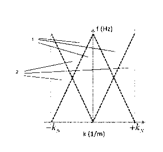
When no periodic signature pattern is used, the inventors have observed that
if the
recorded geophysical data is transformed into another domain (such as
frequency-
wavenumber), substantially all of the data is located in only a portion of the
space of that
domain, i.e. there are portions of the space of that domain where
substantially no data
exists. For instance, when no periodic signature pattern is used and the
recorded data is
transformed into the frequency-wavenumber domain, all of the data fall within
a signal cone
centred around wavenumber k = 0. At all locations in the domain outside of the
signal cone
and up to the Nyquist wavenunnber kN, there is no geophysical data. This is
described in
more detail below with reference to Figure 1.
The inventors have realised that if it were possible to move at least some of
the data
from a particular source recorded at a receiver to a different location in the
other domain,
then more of the space in the other domain could be used.
The inventors have also realised that this could allow for the use of multiple
simultaneous sources, for example, with the data from each source having its
own location
in the other domain. Since data from each source could have its own location
in the other
domain, it is possible to know which data came from which source, and it is
possible to
separate the data from each source. This allows for greater density of data
sampling, and
hence greater efficiency. Similarly, the inventors have realised that when
data from each
source has its own location in the other domain, then the recorded data can be
directly
filtered in the domain in which it is recorded (e.g. time-space or frequency-
space domain) to
extract or reject data from each source.
The inventors also realised that similar principles could also be used to move
the
data signal in the other domain to a location away from data recorded from
noise and/or
interference, or equivalently move noise and/or interference away from the
data signal. The
data from the noise and/or interference could then be used or removed.
Equivalently, the
data could be filtered in the first domain (i.e. the domain in which it is
recorded) to remove
the noise and/or interference.
There may also be numerous other uses and benefits associated with being able
to
move data in the other domain.
The inventors discovered that by using a periodic varying signature on the
generated
geophysical wavefield, the data recorded from that wavefield could, when
transformed into
CA 03000142 2018-03-27
WO 2017/179988 3
PCT/N02016/050197
an appropriate domain, be shifted from its expected location. It is this
principle that the
inventors discovered and from which the numerous advantages and applications
discussed
above, and in more detail below, arise.
Thus, the periodic pattern may be such that, when the geophysical wavefield is
recorded and the recorded geophysical data is transformed into another
appropriate domain,
at least some of the recorded geophysical data is shifted to a location that
is different to the
location where the at least some of the geophysical data would have been had
the varying
signature not been used. The location where the at least some of the
geophysical data
would have been had the varying signature not been used may be the location
where the at
least some of the geophysical data would have been had no varying signature
been used.
When using a seismic wavefield, and when transforming into the frequency-
wavenumber
domain, this location may be a signal cone centred around k = 0.
The method uses a deterministic variation of the signature of the source such
that,
when the generated geophysical wavefield is recorded and transformed into an
appropriate
domain, the location of at least part of the recorded geophysical data is
shifted in that
domain. The signature may be varied in a repeated pattern. The signature may
have a
deterministic periodic variation.
The periodic variation in signature may be a periodic variation of the
signature of
subsequent generated wavefields (e.g. from shot to shot). Thus, the signature
of each
.. generated wavefield may not vary with respect to itself (i.e. each
generated wavefield may
only have one signature), but the signature of each wavefield may vary with
respect to the
signatures of other generated wavefields generated at different locations
and/or times.
An appropriate domain is any domain that shows a shift in the location of the
geophysical data. For instance, the geophysical data may be recorded in a time-
space
domain. The other domain may be a frequency-wavenumber domain or a tau-p
domain.
The shift may be a shift along the axis in the transformed domain.
The method may comprise recording geophysical energy to produce geophysical
data using at least one receiver, the geophysical energy comprising the
propagating
geophysical wavefield generated at the at least one source; and transforming
the
geophysical data into another domain. The other domain may be a domain such
that at
least some of the geophysical data is shifted to a location that is different
to the location in
the other domain where the at least some of the geophysical data would have
been had the
varying signature not been used. Here, the at least some of the recorded
geophysical data
may be all or part of the recorded geophysical data originating from the
propagating
geophysical wavefield generated by the source.
The receiver may record the geophysical energy in the space-time domain.
CA 03000142 2018-03-27
WO 2017/179988 4
PCT/N02016/050197
The transform may be any transform capable of transforming the data into the
appropriate domain. The transform may be a spatial transform. The transform
may be a
Fourier transform. The transform may be a radon transform. The transform may
be a tau-p
transform.
When in the appropriate domain, the shift in the data location due to the
periodic
signature pattern may be a shift in a dimension that is the transform of a
spatial dimension.
When in the frequency-wavenumber domain, the shift may be by kin, e.g. kN,
kNi2, N/3,
etc., where kN is the Nyquist wavenumber.
The at least one receiver may be at a distance from the at least one source.
There may be a plurality of receivers spaced in a generally linear direction.
The at least one source may be moved between different locations between
generating subsequent shots. The source may be moved at a constant velocity,
and the
shots may be fired at constant time intervals, so as to form uniform distance
spacing
between shot locations. However, it may be that, due to environmental factors
for instance
(such as winds, sea currents, etc.), the source may not be moved at a constant
velocity. In
this case, the wavefields may still be generated at constant distance
separation by varying
the time accordingly between subsequent shots. The source may be moved
linearly, so that
shot locations form a straight line. The source may be moved such that a
substantially
uniform grid of shot locations is formed.
The method may comprise isolating the geophysical data originating from the
generated geophysical wavefield from the source from any other geophysical
data that may
be present in the other domain. This may be done by, for instance, muting the
other
geophysical data. The other geophysical data may be from other sources, or
interference, or
noise. The isolated geophysical data originating from the generated
geophysical wavefield
can then be transformed back into the domain in which it was recoded (e.g. the
time-space
domain). Thus, a geophysical data set corresponding to the (or each) source
may be
obtained. This data set can be conditioned (e.g. mathematically) to remove the
variation
imposed on it by the varying signature. For example, the polarity of
appropriate traces can
be changed, or the time of different triggers can be changed. This
conditioning results in a
geophysical data set corresponding to the at least one source that is in a
conventional form
(i.e. as if it has been generated without any varying source signature) but
that has been
successfully separated/isolated from other geophysical energy signals that may
be present.
The method may comprise recording geophysical energy to produce geophysical
data using at least one receiver, the geophysical energy comprising the
propagating
geophysical wavefield generated at the at least one source; and isolating the
geophysical
CA 03000142 2018-03-27
WO 2017/179988 5
PCT/N02016/050197
data originating from the propagating geophysical wavefield generated at the
at least one
source from any other geophysical data that may be present in the other
domain.
The isolating step may comprise filtering the recorded data. This filtering
may occur
in the domain in which the geophysical energy is recorded. This filtering may
occur in the
domain in the space-time domain or the space-frequency domain. Thus, there may
be no
need to transform the recorded data into a transformed domain. The filter
applied may be a
spatial filter, e.g. a space-time filter or a space-frequency filter. The
filter may be
chosen/created/modelled based on the knowledge that the varying signature will
create a
shift in the transformed domain. For example, the skilled person may
appreciate that if data
is going to be shifted in the wavenumber space, then a spatial filter may be
applied in spatial
space so as to isolate a portion of the data that would be shifted if all the
data were
transformed into wavenumber space. The filter can be designed such that it has
the
equivalent data isolation/extraction/rejection properties as the transforming,
isolating and re-
transforming steps discussed above (i.e. it may isolate the same data as the
other isolation
method, but without requiring the step of transforming the data).
For instance, it may be possible to design a filter, which may include a
transform,
that effectively extracts the desired signal (e.g. the signal that would be
shifted in the
transformed domain). The data in the recorded domain can then be convolved
with this filter
to output the sought-after data in the recorded domain. The key point is that
the filtering of
the data in the recorded domain may equally well achieve isolation of the
desired data if a
suitable filter is used. Such a filter may be designed with an understanding
of the theory and
with a knowledge of the varying source signature. Thus, the isolation can be
achieved by
convolving space-time or space-frequency data with a space-time or space-
frequency filter.
The filter may be designed so that it extracts or rejects portion of the
transformed domain
space (e.g. the frequency-wavenumber space). Such a filter may not be limited
to space-
time or space-frequency space; rather it may in any domain in which data is
recorded.
This isolated data may also be conditioned.
Conditioning may occur in the domain in which the geophysical data was
recorded.
Conditioning may occur in the space-time or space-frequency domain.
The periodic pattern may be such that, after transforming the recorded
geophysical
data into the other domain, a first portion of the recorded geophysical data
is shifted to a
location that is different to the location in the other domain where the first
portion of the
geophysical data would have been had the varying signature not been used (i.e.
a shifted
location), and a second portion of the recorded geophysical data is at a
location that is the
same as the location in the other domain where the second portion of the
geophysical data
would have been had the varying signature not been used (i.e. a non-shifted
location).
Looked at another way, the periodic pattern may be such that, after
transforming the
CA 03000142 2018-03-27
WO 2017/179988 6
PCT/N02016/050197
recorded geophysical data into another appropriate domain, a first portion of
the recorded
geophysical data originating from the propagating geophysical wavefield
generated by the at
least one source would be shifted relative to a second portion of the recorded
geophysical
data originating from the propagating geophysical wavefield generated by the
at least one
source. This is different to US 2014/0278119 where all of the data originating
from one
source is shifted.
The second portion may be the remaining portion of the recorded data, i.e. the
recorded data may consist of the first and the second portions. Alternatively,
there may be
other portions present shifted relative to both the first and the second
portions.
Thus, it should be appreciated that the geophysical data originating from the
generated geophysical wavefield may be split into two (or more) different
portions that are
shifted to different locations in the transformed domain. Some of the data
originating from
the source (the second portion) is found at one location and some of the data
originating
from the source (the first portion) is found at location shifted relative to
the second portion.
Thus, it can be appreciated that both the first and the second portions are
incomplete
relative to the full data signal that would have been received at one location
had no varying
signature been used. In the present application, the multiplicative effect of
these missing
portions of the data are referred to as "ghosts" in each portion of the data.
These "ghosts"
may be considered to be functions which, when multiplied with the full data
signal produce
the differently shifted portions of the full data signal. Each data portion
has an associated
"ghost" and the "ghost" associated with each data portion may be different to
the ghost(s)
associated with the other portion(s), i.e. the "ghost" associated with the
first portion (the "first
ghost") is generally different to the "ghost" associated with the second
portion (the "second
ghost"). However, the sum of the all the ghosts should essentially equal 1
(one) as no
energy/data is lost or created when partitioning the data into the first and
second portions,
i.e. substantially no data is lost or created, it is just that some has been
shifted relative to the
remainder. Thus, looked at another way, the first portion of the data may be
equal to the full
data multiplied by the first "ghost" (shifted to the first location), and the
second portion of the
data may be equal to the full data multiplied by the second "ghost". The first
ghost plus the
second ghost may equal 1 (one), where the full data is split into only two
portions.
The inventors have devised a method of reconstructing this partially-shifted
data so
as to obtain fully-shifted data. The inventors have also devised a method of
removing the
second portion (e.g. non-shifted portion) of the data. Once these two steps
are performed, it
should be appreciated that the data will effectively appear to have been fully
shifted. These
two steps may be performed numerically/mathematically. The details of these
steps are set
out below.
CA 03000142 2018-03-27
WO 2017/179988 7
PCT/N02016/050197
When the data has undergone a partial shift due to a varying periodic source
signature, the shifted data may be clearly seen and identified in the
transformed domain
(because it is shifted away from the remainder of the data). However, the non-
shifted
portion of the data originating from the generated wavefield may not be as
clearly identified
because there may be data from other sources at the non-shifted location.
Thus, only the
shifted portion can be reliably identified.
However, since the shifted portion is known, the shifted portion can be
"deghosted".
As mentioned above, the term "ghost" refers to the multiplicative effect of
the missing parts
of the data in the shifted portion (the missing portion being related to the
non-shifted portion).
Hence, "deghosting" refers to removing the ghosts by filling in the missing
portion of the
shifted data portion at the shifted location, i.e. effectively removing the
missing portion of the
data at the shifted location.
In contrast, since US 2014/0278119 shifts all of the data from one source,
there is no
partial shift of the data in US 2014/0278119. The present inventors have
devised a method
that allows all the data from one source to be shifted, even if the source
signature variation is
only such that only a first portion of the data from the source to be shifted:
the second (or
remaining) portion is shifted or accounted for by calculating it from the
first portion. This
method in turn allows for the use of much more primitive signature variations
(such as ones
that cause only partial shifting of the data, such as time dither, amplitude
variations), rather
than the much more precise phase variations required by US 2014/0278119. Using
more
primitive signature variations is advantageous as they are easier to control
and allows for the
use of simpler cheaper more conventional sources, such as air guns.
Essentially, the fact
the inventors have devised a method that works for a signature variation that
only shifts part
of the date from a source leads to a much simpler, more robust and cheaper
method of
acquiring seismic data, in comparison to US 2014/0278119.
The theory behind the method disclosed in US 2014/0278119 is a well-known
shift
property of Fourier Transforms. This shift property requires an exact and
specific modulation
of the source. The present inventors have advanced from US 2014/0278119 in
that they
have devised a method where there is no need to have such exact and specific
modulation
functions as prescribed by the shift property. For the first time, the present
inventors have
devised a new method (based on a new equation that the inventors have derived)
that
allows for (at least) partial shifting of the data even with less exact and
specific modulation of
the source signature. Any non-shifted data can be found from the newly-derived
theory and
then shifted to effectively fully-shift the data, but without requiring the
exact and specific
source signature modulation. This allows cheaper, simpler, more conventional
marine
sources (such as air guns) to enjoy the same benefits as the marine vibroseis
sources
described in US 2014/0278119 (e.g. for simultaneous source acquisition).The
present
CA 03000142 2018-03-27
WO 2017/179988 8
PCT/N02016/050197
method may comprise the steps of: identifying the first portion; and
processing the data to
calculate a full data signal at the shifted location of the first portion
using the identified first
portion. US 2014/0278119 does not include such a step since the data from a
given source
is necessarily always fully shifted. The "full data signal" here is intended
to mean the data
that would have been shifted to the shifted location had the signature been
varied in such a
pattern to achieve this, i.e. that substantially all the data originating from
the generated
wavefield is effectively shifted to the shifted location of the first portion
(by a combination of
actually shifting the data and mathematically/numerically shifting the data).
The calculation of the full data signal at the shifted location of the first
portion using
the identified first portion (i.e. the "deghosting" of the first portion) may
be achieved by
deconvolution of the first portion. The deconvolution is achieved by knowing
the expected
shift of the first portion (e.g. the expected shifted portion and the expected
non-shifted
portion) for a given source signature pattern, which may be derived from
theory. The first
portion can be deconvolved to find the full data signal at the first shifted
location using a
function/equation derived from theory. The first portion can be deconvolved
with a first
ghost, the first ghost having been derived from theory (since first portion is
equal to the first
ghost multiplied by the full data, if the first portion is known and the first
ghost can derived
from theory, the full data can be recovered by deconvolution).
Alternatively to deconvolution, it is also possible to calculate the second
portion,
since the first portion is known (since it has been identified). This can be
calculated by
knowing the expected data shift for a given source signature pattern. This can
be derived
from theory. Once the second portion is calculated, it can be added to the
first portion in the
appropriate first shifted location. This also achieves the desired deghosting.
Deconvolution is preferable since it is achieved in one step and does not
require the
explicit step of calculating the non-shifted portion of the data. However,
both these
techniques achieve the same result of "deghosting" the first portion of the
data.
Once the first portion has been identified, the method may also comprise
processing
the data to remove the second portion of the data using the identified first
portion.
This may be achieved by effectively calculating the second portion from the
first
portion. This may be done by calculating the full data signal using the first
portion (i.e.
"deghosting" the first portion, as discussed above) and then calculating the
second portion
from the full data (i.e. "reghosting" the full data, using a ghost function
corresponding to the
second portion). This operation may be thought of as "reghosting" the
"deghosted" first
portion so that the "reghosted and deghosted" first portion has data that only
corresponds to
that of the second portion. This may be achieved by convolution of the full
data signal at the
first shifted location. The convolution is achieved by knowing the expected
shift of the first
portion relative to the second portion (e.g. the expected shifted portion and
the expected
CA 03000142 2018-03-27
WO 2017/179988 9
PCT/N02016/050197
non-shifted portion) for a given source signature pattern, which may be
derived from theory.
The full data (found by deghosting the first portion) can be convolved with a
second ghost,
the second ghost having been derived from theory (since the second portion is
equal to the
second ghost multiplied by the full data, if the full data is known and the
second ghost can
derived from theory, the second portion can be calculated by convolution).
Alternatively to convolution, it is also possible to calculate the second
portion, since
the shifted portion is known (since it has been identified). This can be
calculated by knowing
the expected shift for the first portion for a given source signature pattern.
This can be
derived from theory.
Regardless of whether the calculated second portion is found by "reghosting"
the
"deghosted" first portion, or by direct calculation from the first portion,
once the second
portion is calculated it can be subtracted from the recorded data at the
location of the second
portion (which may be the non-shifted location).
In a particularly preferred embodiment, the numerical/mathematical completion
of the
full data signal at the first shifted location and the removal of the second
portion of the data
from the second location may be carried out simultaneously, or in a single
step, for example
by using a common filter.
The net effect of deghosting and reghosting is that the second portion (the
non-
shifted portion) of the data may appear to have effectively been shifted to
the shifted
location. This may be achieved by a data processing technique, as discussed
above.
Alternatively the net effect of deghosting and/or reghosting may be achieved
by
designing an appropriate filter. Using such a filter (as discussed above) may
remove the
need to transform the data into the other domain.
The periodic varying signature can be modelled as a mathematical function that
modulates the generated geophysical wavefield and the recorded geophysical
data.
For instance, when the signature is varied using time dither (see below) such
that the
trigger time of every second generated wavefield from the source is delayed,
or advanced,
by a time dither T the modulating function may be:
(1)
where n is trace number. If the modulating function g(n) is applied to
conventional
(i.e. with no time dither) data f (n), and the Fourier transform of the
product is taken, the
result is
.T(f(n)g(n)) = [1 + e1wT]F (elk) + [1 ¨ ei'T[F(ei(k-70),
(2)
where F(e) = (n)) and F(ei(k-70) =
From equation 2, the F(e) term is centred around k = 0 and is the non-shifted
portion. The F(e0-7)) term is centred around k = kN and is the shifted
portion. As
CA 03000142 2018-03-27
WO 2017/179988 10
PCT/N02016/050197
mentioned above, the shifted portion can be identified and measured from the
recorded and
transformed data, but it may be difficult to measure the non-shifted portion.
However, the
missing parts of the shifted data can be filled in (Le. the "ghosts" in the
shifted portion can be
"deghosted") using Equation 2 (or any other model for a different source
signature pattern)
by deconvolution. Using the equation 2 as an example, the full data can be
calculated
using the first (shifted) portion of the data because first portion = [i ¨
* full data.
Alternatively, the non-shifted portion can effectively be calculated using
Equation 2
(or any other model for a different source signature pattern) because the
shifted portion is
known. Once the non-shifted portion has been calculated, it can be added to
the shifted
portion of the data at the shifted location. These data would effectively look
like fully shifted
data. Further, the calculated non-shifted portion can be deleted from the
recorded data at
the non-shifted location to remove the non-shifted portion in the measured
data, e.g. by
"reghosting" the "deghosted" shifted portion so as to find only the data
corresponding to the
"ghosts" in the first portion, and subtracting the "reghosted deghosted"
shifted data from the
non-shifted data. Using the equation 2 as an example, the second (non-shifted)
portion can
be calculated using the full data (found by "deghosting" the first portion)
second portion =
-1[1 + * full data.
2
The shifted portion may be deghosted using mathematical modelling (e.g. using
equation 2), where the shifted portion and the total data is known from the
transformed data.
After deghosting and/or reghosting, the (fully) shifted data can be isolated
and
processed as discussed above.
However, it may not be necessary to deghost/reghost the data to produce useful
data. For instance, the shifted portion alone can be isolated by muting the
remaining data
(which includes the non-shifted portion), or the shifted portion alone can be
muted leaving
.. the non-shifted portion and any other recorded data from other energy
sources. It may be
that only the shifted data is isolated or removed. (As discussed below, some
of the data
may be shifted and some of the data may not be shifted). If, for example, only
the shifted
data (i.e. non-deghosted shifted data) is removed, then partial residual shot
noise
attenuation can be achieved.
The signature of the source may be any feature of the source that, when
periodically
varied (e.g., from shot to shot), may cause the location shift of at least
some of the data
when transformed into an appropriate domain. For example, the time at which
the wavefield
is generated by the source can be varied, and/or the polarity of the source
and/or the phase
of the source and/or the amplitude of the source can be varied. These are four
examples of
the signature of the source. There may also be other features of the source
that can be
varied periodically so as to case the data shift. For instance, when the
source is an airgun
84222637
11
array, the following parameters influence the signature of the source: number
of guns, geometry
of guns, depth, pressure, timing, water velocity, sea temperature and sea
surface conditions.
Further, signatures of vibrator sources and vibrator arrays may depend on
number of vibrators,
geometry, sweep, sequence, timing/delay/advance and polarity.
As mentioned above, the signature may be varied using time dither. Typically a
source
generates wavefields at regularly spaced times or at regularly spaced
locations as the source is
moved. It is also known to use random dithers in which the times that
subsequent shots are fired
are dithered randomly. However, the present method may use a periodic time
dither pattern (i.e.
when time dither is used to implement the invention, it is periodic). This may
be considered to be
a discrete time dither approach.
A time dither is where the generated wavefields, which would typically be
generated at a
certain time, is instead triggered at a slightly delayed, or advanced, time.
For instance, without
time dither, the generated wavefield may be generated when a moving source
reaches a certain
spatial location (known, for example, by GPS). When the source reaches the
location, the source
triggers and a wavefield is generated. A time dither may be where the source
does not trigger as
soon as the source reaches the given location; instead the source may trigger
at a slightly delayed
time (or it may be triggered at a slightly advanced time just before the
source reaches the given
location). Alternatively, the source, without time dither, may generate
wavefields at equally
spaced times. A time dither in this case may be where the source instead is
triggered at a slightly
delayed, or advanced, time in comparison to its expected trigger time. The
time dither may be
considered to be a deterministic delay, or advance, of the source trigger time
in comparison to an
expected trigger time.
As an example of periodic time dither, every second source shot could be
triggered with a
constant delay of time T. Of course, other time dither patterns may be used,
e.g. every third
generated wavefield, fourth generated wavefield, nth generated wavefield could
be dithered or
different generated wavefields could be dithered by different amounts.
Alternatively, the pattern
may be two consecutive shots without delay, then two consecutive shots delayed
by a constant
time shift, the two consecutive shots without time shift, etc. All that is
necessary is that the dither
pattern is periodic such that it produces a shift in the data when it is
transformed into an
appropriate domain.
The dither time T may be of any length, but may preferably be up to 10ms,
20ms, 30ms,
40ms, 50ms, 100ms or 200ms, preferably between 10ms and 40ms, between 40ms and
200ms,
preferably greater than 200ms.
In some embodiments, the dither time T is preferably substantially less than
the time taken
to move the source between adjacent firing locations. This means that the
selected firing location
Date Recut/Date Received 2023-03-20
84222637
12
is not greatly moved by the delay time T. The dither time T is preferably
substantially less than
the time between generated wavefields, which may typically be up to 5s, lOs or
20s.
In some embodiments, preferably the dither time T is selected so as to avoid
being 712 of
the period of the (dominant) frequency of the geophysical wavefield. This is
to be avoided, if
possible, because when dither time T is 712 of the period of the (dominant)
frequency of the
geophysical wavefield, then one of the terms in equation 2 will be zero, which
can produce issues
during data processing (e.g. dividing by zero causes singularities).
As mentioned above, filters in the recording domain (e.g. space-time) can be
designed to
predict, extract, or reject components of the data that we are interested in
(e.g. from the one or
more sources).
As mentioned above, using time dither may lead to only partial shifting of the
data in the
transformed domain. The origin of this partial shifting is now explained
further.
Taking the case where every second trace has a time dither T compared to
neighbouring
traces, the modulating function that describes how the time dither alters
conventional (i.e. non-
dithered) data f (n) is:
y(n) = (-1)n + (3)
Equation (3) can be written more compactly as, the sum of two modulating
functions (one
of which is a constant with respect to n). This is the same as equation 1:
g (n) = [1 etuq [1 ¨ eiwT1( ¨1)n. (4)
Finally, we apply the modulating function g(n) to the conventional data f (n)
and take the
Fourier transform and obtain the result:
F(f(n)g2(n)) = [1 + ehalF(eik) [1 ¨ eiwT]F(el(k-n)). (5)
Equation 5 shows that the geophysical data will be mapped in two places. Part
of the data
will remain at the signal cone centred around k = 0 and another part of the
data will be mapped to
a signal cone centred around the Nyquist waven umber kN.
As explained above, by only knowing one of these parts of the data we can
predict the
other using equation 5 to "deghost" or "reghost" the data. Of course, any
other equivalent
equation for another time dither pattern can be used for this step.
When time dither is used, the remainder of the signature of the generated
wavefields may
be identical.
Whilst the time dither method has been explained in terms of a delayed time
shift, it should
be understood that this is exactly equivalent to generating wavefields early
by the same time shift
(depending on which wavefields you consider as being the un-shifted
wavefields).
Date Recut/Date Received 2023-03-20
CA 03000142 2018-03-27
WO 2017/179988 13
PCT/N02016/050197
Time dither may be the preferred signature variation because it can be
performed
using conventional sources (e.g. an airgun), i.e. there is no need for any
special or adapted
source.
Additionally or alternatively, the signature may be varied by varying the
polarity of the
generated geophysical wavefield. The polarity may be varied from geophysical
wavefield to
geophysical wavefield such that polarities alternate in sequence. This is
particularly useful
when using the present method in modelling geophysical wave propagation, full
waveform
inversion, or reverse time migration.
As an illustrative example, the alternating sequence may be such that every
second
generated wavefield has opposite polarity (e.g. +1,-i, +1,-I etc.).
In this case, a recorded common receiver gather will have every second trace
with
flipped polarity. This may be represented as the following modulating function
having been
applied to a conventional data set f(n) where all traces had the same source
signature:
g (n) = (-1)n .
(6)
Equation 6 can also be written as
g (n) = e 17rn .
(7)
By applying the function g (n) in equation 7 as a modulating function to data
f(n)
before taking a (normalized) discrete Fourier transform:
T(f(n)) = F(e),
we obtain
T(f(n)gl(n)) = (n)e inn) = F (ei(k-70),
(8)
Equation 8 shows that modulating a function with equation 6 results in a
wavenumber
shift by the Nyquist wavenumber kN.
Thus, it can be appreciated that when alternating polarity flips are used, the
recorded
data, once transformed into an appropriate domain, will be shifted away from
the location
where the data would have been had no varying signature been used.
As another example, a second generated geophysical wavefield may have the same
polarity as a first generated geophysical wavefield, a third generated
geophysical wavefield
may have opposite polarity to the second generated geophysical wavefield, a
fourth
generated geophysical wavefield may have the same polarity as the third
generated
geophysical wavefield, a fifth generated geophysical wavefield may have
opposite polarity to
the fourth generated geophysical wavefield, a sixth generated geophysical
wavefield may
have the same polarity as the fifth generated geophysical wavefield, (i.e.+1,
+1, -1, -1, +1,
+1, -1, -1). This may be considered as alternating polarity of pairs of
geophysical
.. wavefields. Such a sequence leads to shift in the data of + kN/2.
CA 03000142 2018-03-27
WO 2017/179988 14
PCT/N02016/050197
Any other sequence can be used. All that is necessary is that the polarity
pattern is
periodic and produces a shift in the data when it is transformed into an
appropriate domain.
When the polarity is varied, the remainder of the signature of the generated
wavefields may be substantially identical.
Polarity variation and time dither may both be used together. The remainder of
the
signature may be substantially identical.
Varying the polarity of the source may be achieved in a number of ways.
More generally, in comparison with the specific time dither example of
equations 3-5
and the specific polarity example of equations 6-8, the following general
mathematical
description is applicable for a periodically-varying source signature. The
following
mathematical description is applicable when a source is excited with the same
signature at
all even source location numbers and when, at all odd source location numbers,
the source
signatures are also identical to each other but differ from the source
signature at the even
source location numbers such that the source signature at the odd source
location numbers
is a scaled or filtered version of the source signature at even source
location numbers. Let
this convolution filter be denoted by a(t), with frequency-domain transform
A(cp). Analysed
in the frequency domain, a receiver gather (e.g. one receiver station
measuring the response
from a sequence of sources) recorded in this way, can be constructed from the
following
modulating function g (n) applied to a conventionally sampled data set:
g (n) = (1 + (-1)n) + ii1(0))(1 ¨ (-1)71) (9)
which can also be written as
g (n) =(1 + et') + A(w)(1 ¨ et') (10)
Equation 10 is a more general formulation of equation 1 and equation 6. In
equation
1 (e.g. for period time dither, T), A(a)) = euT. In equation 6 (e.g. for
periodic polarity
changes), A((.0) = ¨1. Other possible signature variations are also possible
and can be
represented as A(w) = 1, A(w) = 0, A(w) = 1 + e" T
By applying (e.g. record by record temporal convolution) the function g (n) in
equation 9 as a modulating function to data f (n) before taking a (normalized)
discrete
Fourier transform in space (N uniformly space source points over n):
N-1
1
F(k) = f (70e-i2nknnv
n=o
we obtain
N-1
1
H(k) = f (n)g (n)e-i2irkn/N
n=0
1-A(co)
=l+A(a)) F(k) ___________________________________ FOC ¨ kN) (11)
2 2
CA 03000142 2018-03-27
WO 2017/179988 15
PCT/N02016/050197
which follows from a standard Fourier transform result.
Equation 11 shows that the recorded data f will be mapped into two places in
the
spectral domain as illustrated in Figure 2. Part of the data will remain at
the signal cone
centred around k = 0 and part of the data will be mapped to a signal cone
centred around
k = kN.
The amount of data that is shifted from k = 0 to k = kN and the amount of data
that
remains at k = 0, depends on the function A(co).
i-A(co)
The fraction of the data that is shifted from k = 0 to k = kN is given by H_ =
2
1+A(co)
__________________________________________________ The fraction of the data
that remains at k = 0 is given by H+ = 2 .
When A(co) = 1. H_ = 0 and 11+ = 1. Thus, all the data remains at k = 0.
When A(w) = ¨1. H_ = 1 and 1/ = 0. Thus, all the data is shifted to k = kN.
When A(co) = 0. H_ = 1/2 and 11+ = 1/2. Thus, half the data is shifted to k =
kN and
half of the data remains at k = 0.
When AGO = 1/2. H_ = 1/4 and II+ = 3/4. Thus, one quarter of the data is
shifted
to k = kN and three quarters of the data remains at k = 0.
When A(co) = e" H_ = (1 ¨ e"T)/ 2 and H+ = (1 + e"T)/2. Thus, a frequency-
dependent portion of the data is shifted to k = kN and the remaining portion
remains at k =
0. For instance, when w = 27117, , H_ = 0 and H_ = 1, so none of the data with
a frequency of
co = ¨2nn is shifted to k = kN and it all remains at k = 0; and when co =
7r(2n + 1)/T, H_ = 1
and H_ = 0, so all of the data with a frequency of co= n-(2n+1)/T is shifted
to k = kN and
none remains at k = 0.
When A(co) = 1 + et' H_ = ¨e" / 2 and H+ = 1 + eiwT / 2. Thus, a frequency-
dependent portion of the data is shifted to k = kN and the remaining portion
remains at k =
0.
Importantly, and as has been discussed in detail above, by knowing or
observing one
of the portions of the data (e.g. the shifted portion, or the none-shifted
portion), it is possible
to predict the other portion of the data. In the present method, it is
therefore not necessary
to fully shift the data, which means simpler, more primitive source signature
variations (such
as time dither or amplitude changes) can be used. In turn, this allows the
present invention
to be performed using simple sources, such as air guns. This is different to
US 2014/278119
where it is necessary to use a very strict phase variation in order to fully-
shift the data from a
source. The strict phase variation can only be performed using marine vibrator
sources.
Returning to the present method, a marine vibroseis source may be used. The
marine vibroseis source enables a high degree of control of the source
signature and
CA 03000142 2018-03-27
WO 2017/179988 16
PCT/N02016/050197
emitting a signal with opposite polarity is fairly straightforward. However,
they are expensive
and time-consuming to use. It may therefore be preferable to use a simpler
source, which
(in contrast to US 2014/0278119) the present method allows the use of.
A water gun may be used. A water gun source has a main peak that has negative
.. polarity instead of positive polarity and could therefore be used in
combination with an airgun
source (which has a main peak that is positive) to acquire the desired data.
Air gun sources may be used. The air gun sources may be located relative to
each
other such that they effectively produce signatures that are substantially
opposite in polarity.
It should be noted that, in modelling, reverse time migration, inversion or
imaging
applications, it is not necessary to have any particular apparatus that can
achieve the
desired source signature variation. Rather, the source can simply be chosen
and modelled
synthetically, so it is irrelevant how the signature could be varied in the
"real life" scenario.
The method may comprise varying the signature of the at least one source such
that,
once geophysical energy comprising the generated geophysical wavefield and
another
signal is recorded and the recorded geophysical data is transformed into
another appropriate
domain, the recorded geophysical data originating from the generated
geophysical wavefield
will be shifted away from recorded geophysical data originating from the other
signal. The
other signal may be noise, interference, or one or more other sources.
At least two sources may be used to simultaneously generate geophysical
wavefields. The first source may have a varying signature. The second source
may have
no varying signature, or may have a different varying signature. Thus, once
the geophysical
energy is recorded and transformed into another appropriate domain, the
geophysical data
from the first source will be shifted away from the geophysical data of the
second source.
There may be any other number of sources, each with a different signature such
that
all data from all sources are separated from one another after an appropriate
transform.
In the prior art, attempts have been made to record seismic data using
multiple
simultaneous sources by using random time dithers or encoding sources using
orthogonal
sequences.
The present method provides an improved method for using two (or more)
simultaneous sources because the recorded data from each source can be shifted
in the
transformed domain, and so the data from each source can be separated, and
therefore
identified and isolated, from the recorded data from the other source(s).
This is a particularly important use of the present invention, as using
multiple sources
can decrease the amount of computation required during modelling (modelling
can be very
computationally heavy, so this is an important consideration). For instance if
two sources
are used simultaneously in modelling, computation required to obtain the same
amount of
data can be a half, and if three sources are used simultaneously, computation
can be
CA 03000142 2018-03-27
WO 2017/179988 17
PCT/N02016/050197
reduced to a third. Theoretically, if n sources are used simultaneously, the
computation
required to obtain the same amount of data in comparison to a single source is
1/n.
Similarly, using multiple sources can increase the rate at which geophysical
data is
acquired during acquisition. For instance, if two sources are used
simultaneously, data can
be acquired at approximately twice the rate in comparison to a single source,
and if three
sources are used simultaneously data can be acquired at approximately three
times the rate.
Theoretically, if n sources are used simultaneously, data can be acquired n
times faster.
Thus, when multiple simultaneous sources are used, the present method can
allow
the data from at least one of the sources to be identified in the data
recorded by the receiver.
This can be useful in many different techniques. For instance, when using a
source array
(which typically comprises a plurality of smaller source elements spread over
an area), it can
be desirable to interpolate data to positions between locations at which shots
are fired.
Knowing which recorded wavefield came from which source can greatly ease this
calculation.
Further, using multiple sources can allow for a wider range of frequencies to
be used.
For instance, a low frequency source and a high frequency source could be used
simultaneously, and/or airgun source(s) and vibrator(s) could be used
simultaneously.
Without the present method, at intermediate overlapping frequencies, the
recorded data from
these two sources would interfere. However, the present method can be used to
separate
the recorded data from such sources. Thus, the method may be used for broad
band
seismic acquisition or modelling. In broadband acquisition or modelling, one
or more low-
frequency generating source(s) (such as the seismic equivalent of a
"subwoofer") may be
used simultaneously with a conventional higher frequency source.
Further, using multiple sources, whose data can be separated and identified
using
.. the present method, can have benefits when performing reverse time
migration and full
waveform inversion.
The at least two sources generate their respective geophysical wavefields
simultaneously. Simultaneous means that the at least two sources produce
geophysical
wavefields over the same time period. It does not necessarily mean that the at
least two
sources are triggered such that they produce wavefields at exactly the same
time. For
instance, when dither is used, the wavefields may intentionally be generated
at different
times. Of course, when polarity changes are used, the multiple sources may (or
may not)
produce wavefields at exactly the same time.
The method may comprise selecting the varying signature such that, once the
recorded geophysical data is recorded and transformed into another domain, the
portion of
CA 03000142 2018-03-27
WO 2017/179988 18
PCT/N02016/050197
the recorded geophysical data originating from the generated wavefield will be
at least
partially shifted away from an interference portion of the recorded seismic
data.
The generated propagating geophysical wavefield may be affected by interfering
geophysical energy (e.g. from other geophysical wavefields, possibly produced
by another
nearby geophysical survey, or background noise). When this occurs the recorded
geophysical data may comprise a signal portion from the generated geophysical
wavefield
and an interference portion from the interfering geophysical data. In order to
remove the
interference portion, the signature pattern should be varied such that the at
least some of the
signal portion will be at least partially shifted away from the interference
signal in the
transformed domain.
Conventional geophysical interference reduction techniques are not effective
when
the geophysical interference is propagating from the broadside of the line of
the receivers.
The present method can handle these interferences well.
The operator may choose the pattern on the basis of prior knowledge or
estimations
of the geophysical interference. In the case where the interference is from a
neighbouring
survey, the operator may choose the pattern on the basis of the known signal
coming from
the neighbouring survey so as to shift the signal portion from the interfering
portion.
The pattern may be chosen so that the signal portion is shifted as far from
the
interference portion as possible.
The method may further comprise removing the interference portion.
The interference portion may have a dominant frequency, and the method may
comprise using a time dither of approximately the same as, a half of or a
quarter of the
period of the dominant frequency. This time dither may be on every second
generated
wavefield.
The method may comprise selecting the varying signature such that, once the
geophysical data is recorded and transformed into another domain, a residual
shot noise
portion of the recorded geophysical data will be at least partially shifted
away from the
portion of the geophysical data originating from the generated geophysical
wavefield..
The generated propagating geophysical wavefield may be affected by residual
shot
noise. When this occurs, the recorded geophysical data may comprise a signal
portion from
the generated geophysical wavefield and a residual shot noise portion from the
residual shot
noise.
Residual shot noise occurs in geophysical traces due to each trace covering a
finite
time period. A trace typically starts when the geophysical wavefield is
produced and will end
when (or before) the next geophysical wavefield is produced. However, when the
next trace
is recorded, there may be some residual shot noise (e.g. from deep
reflections) from
previous geophysical wavefields that are recorded. Whilst this is undesirable,
it is difficult to
CA 03000142 2018-03-27
WO 2017/179988 19
PCT/N02016/050197
avoid. One prior art method of avoiding residual shot noise is to lengthen the
time of each
trace. However, this in turn increases the time between subsequent generated
wavefields,
which is inefficient.
In some applications, the "residual shot noise" may actually be part of the
useful/wanted signal. Such an application is discussed below, where
effectively the rate at
which shots and traces are triggered is increased such that the time between
generating
subsequent shots may be less than the time taken for the geophysical wavefield
energy
signal associated with each generated geophysical wavefield to be completely
recorded by
the receiver.
Using the present method, the residual shot noise can be shifted away from the
desired signal from the source in the appropriate domain such that the
residual shot noise
can be identified. The residual shot noise may be removed/muted, or separated
and used
as geophysical data.
Thus, using the present method, there is less of a need to wait for residual
shot noise
to die down before taking a subsequent trace. Thus, the time interval between
subsequent
generated geophysical wavefields (and hence traces) can be reduced, which can
increase
the density of the data (e.g. spacing between locations where geophysical
wavefields are
generated by the at least one source), or can increase the speed at which the
data is taken
(e.g. increase the tow speed of the source). This increases the efficiency of
geophysical
data gathering.
The residual shot noise portion may have a dominant frequency.
The method may comprise using a time dither of approximately the same as, a
half of
or a quarter of the period of the dominant frequency of the residual shot
noise. This time
dither may be on every second generated wavefield.
As mentioned above, the periodic pattern of the varying polarity of
sequentially
generated geophysical wavefields may be: a second generated geophysical
wavefield
having the same polarity as a first generated geophysical wavefield, a third
generated
geophysical wavefield having opposite polarity to the second generated
geophysical
wavefield, a fourth generated geophysical wavefield having the same polarity
as the third
generated geophysical wavefield, a fifth generated geophysical wavefield
having opposite
polarity to the fourth generated geophysical wavefield, a sixth generated
geophysical
wavefield having the same polarity as the fifth generated geophysical
wavefield, (i.e.+1, +1, -
1,-i, +1, +1,-I, -1), etc.
This pattern may be particularly advantageous for identifying (and hence
removing)
residual shot noise. In a trace, the largest residual shot noise typically
comes from the
generated wavefield of the previous trace. This is therefore the most
important residual shot
CA 03000142 2018-03-27
WO 2017/179988 20
PCT/N02016/050197
noise to deal with. Using the above pattern allows for this residual shot
noise to be identified
as follows:
Say the first generated wave has polarity +1, the second has polarity +1, the
third
has polarity -1 and the fourth has polarity -1 (etc.). The main signal in the
first trace will have
polarity +1, the main signal in the second trace will have polarity +1, the
main signal in the
third trace will have polarity -1, and the main signal in the fourth trace
will have polarity -1.
However, the largest component of residual shot noise in a given trace (i.e.
that from the
previous shot) will have the same polarity as the main signal in the previous
trace. So the
largest component of residual shot noise in the first trace will have polarity
-1 (same polarity
as main component of preceding trace) the largest component of residual shot
noise in the
second trace will have polarity +1 (same polarity as main component of first
trace), the
largest component of residual shot noise in the third trace will have polarity
+1 (same polarity
as main component of second trace) and the largest component of residual shot
noise in the
fourth trace will have polarity -1 (same polarity as main component of third
trace).
We therefore have a set of traces,
tn(main signal polarity, residual shot noise polarity), as follows: t1(+1,
¨1), t2(+1, +1),
t3(-1,+1), t4(-1,-1), etc.
The method may comprise, prior to transforming the data, multiplying all
traces
having "+1" polarity as their main signal (i.e. the traces that are generated
by a source with
+1 polarity with, in this case t1 and t2) by -1. This leaves the set of traces
with polarity as
follows: t1(-1,+1), t2(-1,-1), t3(-1,+1), t4(-1,-1), etc.
Alternatively (and completely equivalently, given the terms +1 and -1 are
merely
depicting opposite polarities), the method may comprise, prior to transforming
the data,
multiplying all traces having "-1" polarity as their main signal (i.e. the
traces that are
generated by a source with -1 polarity with, in this case t3 and t4) by -1.
This leaves the set
of traces with polarity as follows: t1(+1,-1), t2(+1,+1), t3(+1,-1),
t4(+1,+1), etc.
Regardless of which of these methods is carried out (they are essentially
equivalent),
the result is that all the main signals in the set of traces have the same
polarity and the
residual shot noise has alternating polarity. Thus, equation 6 above applies
to the residual
shot noise component only, and not the main signal component.
Thus, when an appropriate transform of the set of traces is taken, the
residual shot
noise may be shifted relative to the main signal. In the specific case given
here, the shift is
the Nyquist frequency kN.
In this application of the present method, it is preferable to have the at
least one
source generate the wavefields at regular, constant time intervals, e.g.
rather than at regular
spacing intervals. (Of course, if time dither is used, then the regular time
intervals may not
CA 03000142 2018-03-27
WO 2017/179988 21
PCT/N02016/050197
be totally constant, but the average time between shots will be constant, and
the "expected"
shot trigger time (from which time dither is measured) will be constant.)
The method may comprise selecting the varying signature such that, once the
geophysical data is recorded and transformed into another domain, a pressure
wave portion
of the geophysical data will be at least partially shifted away from a shear
wave portion of the
geophysical data.
After reflection from a subsurface structure, the propagating geophysical
wavefield
may comprise reflected pressure waves and reflected shear waves such that the
recorded
geophysical data comprises a pressure wave portion and a shear wave portion.
However,
the shear waves travel more slowly than pressure waves.
A trace typically starts when the geophysical wavefield is produced and will
end when
(or before) the next geophysical wavefield is produced. It is desirable to
record both the
shear and the pressure waves. Before the present method, if it were desired to
record both
the shear wave and the pressure wave, it would be necessary to do so in the
same trace.
This, however, when viewed from the pressure wave alone is not efficient
because of the
delay in the shear wave arrival. Thus, similar to the residual shot noise
discussed above,
one prior art method is simply to have increased of trace times, and increased
intervals
between generated geophysical wavefields. This is inefficient.
Using the present method, the pressure wave and the shear wave may arrive in
different traces. Due to the varying periodic signature of the source, it will
be possible to
separate the pressure and shear arrivals in the transformed domain. Further,
due to the
varying periodic signature of the source it will be possible to know from
which generated
geophysical wavefield the shear wave originated, regardless of which trace it
is recorded in.
The separated shear and pressure waves may both be used as geophysical data
for
analysing the subsea structure. Alternatively, the shear or pressure wave may
be
removed/muted.
Thus, using the present method, there is less of a need to wait for shear
waves to
arrive before taking a subsequent trace. Thus, the time interval between
subsequent
generated geophysical wavefields (and hence traces) can be reduced, which can
increase
the density of the data (e.g. spacing between locations where geophysical
wavefields are
generated by the at least one source), or can increase the speed at which the
data is taken
(e.g. increase the tow speed of the source). This increases the efficiency of
geophysical
data gathering. Additionally, in the case of pressure and shear data
acquisition signal-to-
noise can also be increased due to the fact that shear data tend to be mostly
arriving on the
horizontal component in seabed recordings and pressure waves mostly arrive on
the vertical
component. Thus, after separation of the horizontal and vertical components,
the pressure
data and the shear data may be substantially separated.
CA 03000142 2018-03-27
WO 2017/179988 22
PCT/N02016/050197
The method may comprise generating subsequent geophysical wavefields at a rate
that is faster than is conventionally possible. The time between generating
subsequent
geophysical wavefields may be less than the time taken for the geophysical
wavefield
energy signal associated with each generated geophysical wavefield to be
completely
recorded by the receiver.
In conventional systems, traces are typically triggered with each shot. Each
trace
therefore records the wavefield signal generated from each shot. The wavefield
signal takes
a certain amount of time to completely be recorded by the receiver (by
"completely" recorded
here, we are not referring to residual noise, we are referring to only the
wanted/useful signal
from the generated wavefield).
However, as mentioned in relation to the residual shot noise application, the
traces
must be of a certain length so as to record all of the wanted/useful
propagating wavefield
signal from the respective shot, and to avoid too much interference/noise from
previous
shots. Since the trace and the shot are triggered together, the minimum trace
length leads
to a minimum time between shots, and so limits the rate at which data can be
acquired.
However, in the present invention, it is possible to fire shots and to record
traces at a
greater rate. If the signature of the source is varied in a suitable periodic
pattern, any given
trace can record the signal (i.e. the wanted/useful data signal) portion from
more than one
source, since the data recorded from each source in each trace can later be
identified/isolated using the present method. This allows data acquisition to
be much faster.
Once the data in a given trace originating from a source shot previously to
the trigger
time of the given trace has been identified/isolated, this data can be added
to the data
recorded for the previous shot (i.e. this data can be concatenated with the
previous data
since this portion of the data has a zero time that corresponds to the trigger
of the given
shot). The previous shot may preferably be the shot for the trace immediately
preceding the
given trace.
For instance, take the case where the signal from a generated wavefield takes
time
to to fully pass the receiver. Using conventional techniques, the system would
be limited to
a shot trigger and trace trigger time interval of to. However, using the
present method it is
possible to simultaneously record the signal portion from two subsequent shots
in the same
trace, and then separate the recorded data from each shot. In this case, shots
and traces
can be triggered at intervals of .'. Further, in the case where it is possible
to simultaneously
record (in the same trace) and then separate the recorded data for n
subsequent shots,
shots and traces can be triggered at intervals of Ln .
CA 03000142 2018-03-27
WO 2017/179988 23
PCT/N02016/050197
The geophysical wavefield, energy and/or data may be a seismic wavefield,
energy
and/or data. The geophysical wavefield, energy and/or data may be a controlled
source
electromagnetic wavefield, energy and/or data.
It should be recognised that this application uses the same principals to
those of the
residual shot noise application, but that what was considered as "noise" now
is "useful"
signal that needs to be moved to its right place (i.e. following the end of
the previously
recorded shot). In other words we deliberately let more of the desired signal
end up as
"residual shot noise" in the next shot(s) where it can be isolated, removed
from the next
shot(s) and added to the appropriate previous shot(s).
The transform may be a Fourier, tau-p or radon transform. The appropriate
domain
may be a frequency-wavenumber domain, or a tau-p domain.
As discussed above, the method may be used to improve the estimation of source-
side gradients. When conducting data acquisition the source may be in the form
of an array
of sub-arrays of sources. The sub-arrays may be separated vertically and/or
horizontally.
Using the present method, data from two or more sources (or sub-arrays of
sources)
in the array can be found. By knowing the data from each source (or sub-
array), the
calculation of the source-side (horizontal and/or vertical) gradient is
greatly eased.
The method may comprise calculating the (horizontal and/or vertical) gradient
of the
source between two or more sources, or two or more sub-arrays.
Similarly, since the data from a specific source can be identified in the
recorded data
using the present method, the calculation for source-side deghosting of the
data is greatly
eased, particularly when data is acquired from multiple sources
simultaneously.
The method may comprise source-side deghosting the recorded geophysical data.
The separated data produced by the present method may be used to reconstruct
or
interpolate the geophysical data on the source-side.
The at least one source may be an airgun source, an airgun source array, a
marine
vibroseis source, a watergun source, a flip/flop source, or an electric and/or
magnetic
source. An electric and/or magnetic source may be an electromagnetic source,
i.e. a source
for producing electromagnetic data. Alternatively or additionally, a
flip/flop/flap source (which
may comprise three source arrays) or a penta-source (which may comprise five
source
arrays) may be used. A flip/flop source, a flip/flop/flap source and a penta-
source are
examples of multi-arrays that can be used as the source of for the present
method. Such
multi-arrays may be towed behind a single vessel.
When a flip/flop source is used with time dither between the flip and flop
shots (e.g.
either all the flip shots or all the flop shots are dithered by a constant
time), the two flip and
flop sources may be staggered in the inline direction to compensate for
differences in
shooting times. The flip/flop sources may be being moved during shot firing at
a constant
CA 03000142 2018-03-27
WO 2017/179988 24
PCT/N02016/050197
velocity. The stagger may be such that the flip and flop shots are spaced
equally in space,
but are dithered in time. For instance, if the flop shot time dither is 0.2s
and the speed of the
source is 2.5m/s, the flop shot may be 0.5m in front of the flop shot. The
flip/flop source
may comprise airgun sources. In this case, the flip/flop source could be
considered to be
one source, and should not be confused with the case of using multiple
simultaneous
sources. (However, a flip/flop source could also be used as two simultaneous
sources, if
they are staggered appropriately in the in line direction.)
Staggering such as this may also be used for any type of source (i.e. not just
flip-flop
sources) when multiple sources are present.
Such a staggering of sources may be particularly important for any application
where
the source is triggered at regular, constant time intervals, e.g. rather than
at regular spacing
intervals. (Of course, if time dither is used, then the regular time intervals
may not be totally
constant, but the average time between shots will be constant, and the
"expected" shot
trigger time (from which time dither is measured) will be constant.) This may
be particularly
relevant for the residual shot noise application discussed above. Staggering
the sources in
such a manner when using constant time triggering allows for the shot
locations to have
constant spatial separation.
The recorded geophysical data may be gathered/sorted in the common receiver
domain. The recorded geophysical data may be gathered/sorted in the common
midpoint
planes domain. The recorded geophysical data may be gathered/sorted in the
common
offset domain. The transform may be carried out on data in either of these
domains.
The geophysical data may be 20 data or 3D data.
For 2D data, the recorded data (which may be in the space-time domain) may be
recorded in one space dimension (e.g. inline or crossline) and one time
dimension. Thus,
only one spatial coordinate may be required for 2D data. When transforming
into the other
domain, the other domain may also be a two dimensional domain. For instance,
when
transforming into the frequency-wavenumber domain, there may only be one
wavenumber
dimension and one frequency dimension. When using a filter, the filter may be
a 20 filter,
and may filter in only one spatial dimension.
For 30 data, the recorded data (which may be in the space-time domain) may be
recorded in two space dimension (e.g. inline and crossline) and one time
dimension. Thus,
two spatial coordinates may be required for 20 data. When transforming into
the other
domain, the other domain may also be a three dimensional domain. For instance,
when
transforming into the frequency-wavenumber domain, there may be two wavenumber
dimensions (e.g. k, and ky) and one frequency dimension (e.g. an (f,kõ,ky)
space). When
using 3D data, the shifting can be performed in more than one dimension (e.g.
k, and/or ky).
CA 03000142 2018-03-27
WO 2017/179988 25
PCT/N02016/050197
This allows for more signature options, more shifting options and more space
into which to
shift the recorded data. When using a filter, the filter may be a 3D filter,
and may filter in only
two spatial dimensions.
The geophysical data may be marine seismic data, seabed seismic data,
permanent
reservoir monitoring data, land seismic data, VSP data, controlled source
electromagnetic
data, electric data and/or magnetic data.
When signals from multiple simultaneous sources are separated by transforming
into
an appropriate domain, it is preferable that the signal band is as narrow as
possible in that
domain. This is so that overlap of the signal bands from the different sources
is avoid or
minimised. For instance, data from each source can be in the form of a signal
cone. The
data from the different sources may be aliased if the signal cones overlap.
When the signals
overlap, it can be difficult to separate the signals from the different
sources. It is therefore an
important consideration to make the widths of the data signals in the
transformed domain as
narrow as possible. The inventors have found several ways of doing this, and
these are
discussed below.
Thus, the method may comprise reducing the width of the data signal
originating from
the at least one source in the other domain. The method may comprise reducing
the
interference of the recorded data originating from multiple sources. This may
be achieved by
applying data processing and de-aliasing techniques to the data in the first
domain, as is
discussed below or any general data processing technique for this purpose, for
instance as
those described in Yilmaz (2001). By signal width we mean, for instance, the
spatial
aperture of the signal cone in fk.
The method may comprise reducing the highest apparent wavenumbers. This may
be done for the data for one or more of the sources. This may be done prior to
transforming,
and may be done mathematically (e.g. using signal processing), or may be done
physically
(e.g. by altering the source-receiver set up). Details on these techniques are
given below.
The method may comprise gathering the data in, or sorting the gather data
into, a
domain that minimises the signal width in the transformed domain. Such a
domain may be
the common receiver domain, common source domain, common midpoint domain or
common offset domain. The common offset domain may be preferred because it
comprises
larger apparent velocities of arrivals than the common receiver domain, and so
the signal
cone will be larger in the frequency-wavenumber domain.
The method may comprise removing low-speed waves of the recorded wavefield,
for
instance the direct wave arrival, the guided water layer wave arrival and/or
the bottom
refraction wave arrival. These slow speed waves are the limiting factor for
the signal cone in
the frequency-wavenumber domain, and removing them reduces the width of the
signal
CA 03000142 2018-03-27
WO 2017/179988 26
PCT/N02016/050197
cone. These arrivals may be removed by modeling these arrivals, and
subtracting them
from the recorded data.
The method may comprise having the source and the receiver far apart (such as
at
least 100m, 200m, 500m, 1000m, or 10000m). If data are recorded far from the
source, due
to the reduced azimuth range between source and receiver, the width of the
signal cone will
be narrower.
Any of these methods may be performed in combination with each other.
Due to the cone-shape of the signal in the transformed domain, the lower
frequency
data will typically not overlap with low frequency data from other sources.
This lower
frequency data may be considered as unaliased data. The threshold frequency up
to which
there is no data overlap and above which there is overlap will depend on the
width of the
signal cones and the separation of the signal cones. The higher frequency data
above the
threshold may be considered to be aliased data.
In order to produce non-aliased data from each source, the inventors have
found the
following techniques.
The method may comprise reconstructing unaliased data for one or more sources
based on the unaliased lower frequency data. There are known techniques for
achieving
this. This method may be performed in combination with any of the wavenumber-
limiting
techniques discussed above.
In broadband modeling/acquisition, the lower frequency unaliased data may
predominantly be from the low frequency source(s). Thus, broadband
modeling/acquisition
data may be particularly easily separated using the present method.
When using multiple simultaneous sources, all of the sources may be of a low
enough frequency such that they do not interfere. Preferably however there may
also be
one higher frequency source. Because there is only one higher frequency
source, its high
frequencies will not interfere with any other signals (and its low frequency
signals will not
interfere with the other low frequency sources because of the cone-shape of
the data).
Thus, the frequencies of the multiple sources may be selected to minimise
interference/aliasing of the data from each source.
It should be appreciated that the method steps discussed above can apply
equally to
modelling and to physical data acquisition.
The method may comprise applying source motion corrections to the recorded
data.
This may be performed using any known technique.
The method may comprise regularising the data. This may occur after
transforming
the isolated data back into the original domain (e.g. the time-space domain),
after filtering or
after conditioning. The data may need to be regularised if the spatial
locations at which the
wavefields were generated by the source are not the desired locations. This
may be the
CA 03000142 2018-03-27
WO 2017/179988 27
PCT/N02016/050197
case if the wavefields were triggered with respect to constant time intervals
rather than with
respect to constant spacing intervals, or if a large time dither was used. The
regularising
may be spatially regularising. Regularising the data can be achieved using
standard
regularising techniques. Regularising can occur in the domain in which the
data was
.. recorded or in the transformed domain.
It should be noted that all "shifts" in the data discussed above are merely
relative
shifts in the transformed domain, i.e. when it is stated that a first data set
is shifted away
from a second, it could equally be thought of as shifting the second data set
away from the
first, or indeed both data sets being shifted relative to another point. The
data in the domain
may be periodic, e.g. in the frequency-wavenumber domain the data may have a
period of
2kN (i.e. data at k and k + 2nkN may be identical). Thus, it should be
understood that the
axes may be altered by effectively shifting all the data. Which data set(s)
is/are being
"shifted" will simply depend on whether the axes in the domain are also
shifted, which can be
freely chosen by the operator.
Further, it should be noted that the "shifted location" is not one specific
location/coordinate in the domain, but rather refers to a shift by the same
amount in the
domain (e.g. data that would have had a coordinate k1 when shifted to the
"shifted location"
has location k1 + kshift and data that would have had a coordinate k2 when
shifted to the
"shifted location" has location k2 + kshift).
In a second aspect, the invention provides a system for generating geophysical
data
comprising at least one source for generating a geophysical wavefield with a
varying
signature, wherein the source is configured to vary the signature of the
geophysical
wavefield in a periodic pattern.
The system may further comprise: at least one receiver for recording
geophysical
energy, the geophysical energy comprising the propagating geophysical
wavefield generated
at the at least one source; and a processor for transforming the recorded
geophysical data
into another domain. The other domain may be a domain such that at least some
of the
recorded geophysical data is shifted to a location that is different to the
location in the other
domain where the at least some of the geophysical data would have been had the
varying
.. signature not been used. Here, the at least some of the recorded
geophysical data may be
all or part of the geophysical data originating from the propagating
geophysical wavefield
generated by the source.
The system may comprise at least one receiver for recording geophysical
energy, the
geophysical energy comprising the propagating geophysical wavefield generated
at the at
least one source; and a processor for isolating the geophysical data
originating from the
propagating geophysical wavefield generated at the at least one source from
any other
CA 03000142 2018-03-27
WO 2017/179988 28
PCT/N02016/050197
geophysical data that may be present in the other domain. The processor
comprises a filter
for filtering the recorded data. The filter may be the filter discussed above
in relation to the
method.
The system may further comprise at least two sources each for generating a
geophysical wavefield, the first source having no varying signature and the
second source
having the varying signature, such that the geophysical data from the second
source will be
shifted away from the geophysical data of the first source. Alternatively,
each source could
have a different varying signature, such that the geophysical data from the
second source
will be shifted away from the geophysical data of the first source.
The system may be configured to perform any of the above-discussed methods.
The
system may comprise any of the features discussed in relation to the above-
discussed
methods.
In a third aspect, the invention provides a computer program product
comprising
computer readable instructions that, when run on a computer, is configured to:
cause at least
one source to generate a geophysical wavefield with a varying signature,
wherein the
signature is varied in a periodic pattern.
The computer program product may be configured to perform any of the methods
of
the first and/or second aspects. The computer program product may be
configured to cause
any of the systems of the first and/or second aspects to perform any of the
above discussed
methods.
In a fourth aspect, the invention provides a method of prospecting for
hydrocarbons.
This method comprises performing any of the methods of the first and/or second
aspects,
possibly using the computer program product of the third or seventh aspects.
This method
may comprise using the system of the second aspect and/or the computer program
product
.. of the third aspect to prospect for hydrocarbons.
The method may comprise using the generated geophysical data to identify
locations
for drilling and/or identifying well locations using the model. The method may
comprise
drilling at and/or into said identified locations.
In a fifth aspect, the invention the invention provides a method of producing
hydrocarbons. The method may comprise performing any of the methods of the
first and/or
fourth aspects, and producing hydrocarbons through the drilled wells. This
method may
comprise using the system of the second aspect and/or the computer program
product of the
third aspect to produce hydrocarbons.
Preferred embodiments of the invention will now be discussed, by way of
example
only, with reference to the accompanying drawings, in which:
CA 03000142 2018-03-27
WO 2017/179988 29
PCT/N02016/050197
Figure 1 shows an illustration of what a common receiver gather seismic data
set
may look like in fk after conventional shooting (left) and flipping polarity
on every second
shot (right).
Figure 2 shows an illustration of what a common receiver gather seismic data
set
may look like in fk after using a time dither on every second shot.
Figure 3 shows an example acquired data set used to illustrate an embodiment
of the
present invention.
Figure 4 shows the fk spectrum of the data shown in Figure 3.
Figure 5 shows the fk spectrum of the data shown in Figure 3, but where the
polarity
of every second trace has been flipped, emulating a survey where every second
shot has
opposite polarity to the shots right before and after.
Figure 6 shows the fk spectrum of the data shown in Figure 3 but flipping
polarity on
traces such in the pattern +1, +1,-I, -1, +1, +1,-I, -1, etc., emulating a
survey where the
polarity of shots are flipped in that pattern.
Figure 7 shows the fk spectrum of the data shown in Figure 3 but where a time
shift
of 10ms has been applied to every second trace, emulating a survey where a
time dither of
10ms on every second shot is used.
Figure 8 shows the fk spectrum of the data shown in Figure 3 but where a time
shift
of 20ms has been applied to every second trace, emulating a survey where a
time dither of
20ms on every second shot is used.
Figure 9 shows the fk spectrum of the data shown in Figure 3 but where a time
shift
of 40ms has been applied to every second trace, emulating a survey where a
time dither of
40ms on every second shot is used.
Figure 10 shows the fk spectrum of the data shown in Figure 3 but where a time
shift of 200ms has been applied to every second trace, emulating a survey
where a time
dither of 200ms on every second shot is used.
Figure 11 shows the data of Figure 7 where equation 17 has been used to
properly
"deg host" the signal cone centred around the Nyquist wavenumber so that the
shifted data
now again corresponds to the original data (but shifted to the Nyquist
wavenumber).
Figure 12 shows the data shown in Figure 11 where equation 17 has been used to
properly "reghost" the signal cone centred around the Nyquist wavenumber and
subtract it
from the signal cone centred around k = 0. We are left with a data set with
one signal cone
only that has been shifted to the Nyquist wavenumber.
Figure 13 shows a possible configuration for a flip/flop source to achieve a
spatially
fully uniform distribution of shot points when time dither is used.
CA 03000142 2018-03-27
WO 2017/179988 30
PCT/N02016/050197
Figure 14 shows the effect on signal and residual shot noise arrivals after
backing off
time shifts.
In one embodiment, the present method relates to a new way to acquire seismic
data
based on how seismic sources are utilized. The key realization is that by
varying the source
signature from shot to shot it is possible to separate data from other signals
or noise. In one
embodiment of the invention a source boat shoots every second shot with a
certain source
signature while every intermediate shot is fired with the same source
signature but with
opposite polarity. After a frequency-wavenumber (fk) transform of such data,
for instance
sorted into a common receiver gather, the data will populate opposite ends of
the k axis in
the fk spectrum compared to where a conventionally shot data set with the same
source
signature for every shot would end up. The theory of this is discussed in
detail below. We
can exploit this effect for a number of different applications, which are each
discussed in
greater below:
1. Simultaneous source acquisition.
The technique described here offers a new way to acquire simultaneous source
data.
Two or more sources can be fired simultaneously, and the data received from
them
can be separated, through the use of different varying signature patterns.
2. Seismic interference cancellation.
By using the present method we can adapt the recorded data signal so as to
shift the
data originating from the one or more sources from seismic interference. To
achieve
this, the optimal signature pattern can be adapted as the measurements are
taken.
3. Residual shot noise attenuation.
By choosing the signature variation pattern appropriately, we can use the
methodology to isolate residual shot noise that can be removed without
affecting the
signal at all. Benefits include better signal-to-noise ratio in the acquired
data, faster
acquisition of seismic data, denser acquisition of seismic data, better low
frequency
acquisition (low frequencies tend to be most affected by residual shot noise).
4. Seismic data modelling and reverse time migration (RTM).
Since the method allows multiple sources to be used simultaneously, there can
be
dramatic efficiency savings when modelling. For instance, if two sources are
used,
there are immediate efficiency savings are up to a factor of 2.
5. Broad-band seismic acquisition.
As is discussed further below, once shifted, there may be some aliasing of the
data
from multiple sources. However, data from multiple sources are always
unaliased for
low frequencies using our method. We can use purpose built low frequency
sources
and guarantee that these will not interfere with the acquisition of
conventional data.
6. Cost-effective acquisition of shear-wave data.
CA 03000142 2018-03-27
WO 2017/179988 31
PCT/N02016/050197
Similarly to the RSN application, by choosing the signature variation pattern
appropriately, we can use the methodology to isolate the shear-wave arrival
from the
pressure-wave arrival.
7. Deghosting and source-side gradients for interpolation.
By applying the varying source signature pattern to different sub-arrays
within an
airgun array, it is possible to separate the responses from sub-arrays such
that
horizontal gradients on the source side can be computed. These are useful for
source-side deghosting and other applications.
Theory
In the following discussion of the theory behind the present method,
techniques that
exploit the fact that the fk space in marine seismic data contains significant
portions that are
empty limited by apparent propagation velocities that cannot be lower than the
propagation
velocity in water are discussed. However, other domains and geophysical data
types may
also be used.
The left part of Figure 1 illustrates a frequency-wavenumber (fk) plot of, for
instance,
a common shot gather or common-receiver gather from a marine seismic survey.
All signal
energy sits inside a "signal cone". This is because the slowest possible
apparent velocity of
any seismic energy will correspond to the propagation velocity of water.
Outside this signal
cone the data is zero in the fk plot.
The inventors have found that by varying the source signature form shot to
shot
thereby introducing different shooting patterns it is possible to make much
better use of the
available fk space. The data may be deliberately aliased.
One example of such a shooting pattern is to shoot all even shot points with a
certain
source signature and interleave all odd shot points using the same source
signature but with
opposite polarity. For such a data set, a recorded common receiver gather will
have every
second trace with flipped polarity, or in other words, the following
modulating function has
been applied to a conventional data set where all traces had the same source
signature:
gi(n) = (-1)n . (12)
Equation 12 can also be written as
g1(n) = e1. (13)
By applying the function 9i in equation 13 as a modulating function to
conventionally
recorded (i.e. data recorded without using a varying source signature) data f
(n), where n is
trace number, before taking a (normalized) discrete Fourier transform:
(f(n)) = F (eik),
we obtain
CA 03000142 2018-03-27
WO 2017/179988 32
PCT/N02016/050197
F(f (n)gi(n)) = (f(n)e') = F(ei(k-70), (14)
which is a standard Fourier transform result (wavenumber shift). That is,
modulating
a function with equation 12 results in a wavenumber shift by the Nyquist
wavenumber.
The right part of Figure 1 shows what such a data set would look like after an
fk
.. transform. Note that the signal cone has now been shifted laterally so that
it is centred at the
Nyquist wavenumber kN with half the signal cone on the negative side of the
wavenumber
axis and the other half on the positive side.
Next we consider the case that we refer to as time dither. In such a case,
every
second trace may have a time dither T compared to neighbouring traces. The
modulating
.. function that we wish to apply can be written as a superposition of several
functions with
known transforms:
92(n) ¨
(¨ l)t (_ ire tau' et(a- (15)
2 2 s 2
Note that the exponentials are due to Fourier transforms in a different
dimension
(Fourier transforms of a time shift T) and are constants in the (space)
dimension that we
consider.
Equation 15 can be written more compact as, the sum of two modulating
functions
(one of which is a constant with respect to trace number n):
g 2(n) = [1 eicl +12 [1 ¨ ei'T[(-1)n (16)
Finally, we can obtain the result:
F(f (n)g2(n)) = [1 + ei'r[F(eik) +[i ¨ ei'T[F (e"-')). (17)
Equation 17 shows that the seismic data will be mapped in two places. Part of
the
data will remain at the signal cone centred around k = 0 (i.e. the part with
frequencies
around GO = n-(2n + 1)/T) due to the first term of equation 17 and part of the
data will be
mapped to a signal cone centred around the Nyquist wavenumber kN (i.e. the
part with
frequencies around CD = ) due to the second term in equation 17. Figure 2
illustrates
that, in comparison to conventional data (left part of Figure 1), the data has
been partially
shifted to kN. Specifically, the data in the signal cone 1 centred around k =
0 has not been
shifted, but the data in signal cone 2 centred around k = kN has been shifted.
Thus, from equation 12 it is clear that when polarity flips are used,
substantially all
.. the data from the source will be shifted. However, from equation 17 it is
clear that when
using time dither data will only be partially shifted.
However, the inventors have realised that if one of the terms of equation 17
is known
from recorded data, then the other term can be predicted using equation 17.
This is a critical
observation that makes time dither as useful as flipping polarities.
CA 03000142 2018-03-27
WO 2017/179988 33
PCT/N02016/050197
Since it is not necessary to flip the polarity using time dither as the
varying signature,
time dither can be performed using conventional sources (such as airguns).
Flipping
polarity, on the other hand, may require the use of more specialist equipment,
such as
marine vibroseis.
As can be appreciated, the theory behind the present method may be presented
in
numerous different ways. Another way of considering the origins of the effect
of varying the
source signature from shot to shot is that the recorded data then can be
considered to
consist of a sum of individual datasets, where each data set has one
individual/specific
source signature. Say, when the source signature is delayed in every second
shot, the data
can be considered to be the sum of two datasets: one without source delay, and
the other
with source delay. The full data will have a sampling frequency of ks. The two
individual
datasets then will have sampling frequency k2/2. This property leads to all
the benefits in
acquisition, processing, modeling and inversion that have been described in
the invention.
Example in practice
Figure 3 shows an example data set from a seismic survey. Although the data
comprise a common shot gather sampled at 6.25m trace spacing, we will
manipulate the
data as if it were a common receiver gather where every second trace
corresponds to a new
source location (unrealistically densely sampled at 6.25m source spacing).
Only a small part
of the data has been selected such that for instance all near offsets are
missing. This will
generate some noise artefacts when transforming the data into the fk space.
Figure 4 shows an fk plot of the data in Figure 3. This is an fk plot of data
gathered
using a conventional shooting pattern (e.g. the left-hand side of Figure 1).
In this particular
case, most of the data arrive with negative wavenumber. This is because the
source is
located in front of the spread. We can clearly see the outline of a signal
cone bounded by
the minimum observable apparent velocity of arrivals (water velocity). We see
how some
energy "bleeds" outside the signal cone. This is an artefact caused by the
fact that we chose
a small section of data. A more complete data set (such as split spread data
set with near
and far offsets) would be better focused within the signal cone. However, the
data shown
here are good enough to serve the purpose of illustrating our concept.
Figure 5 shows an fk plot where every second trace has opposite polarity to
every
second trace (e.g. +1,-I, +1, -1, +1, -1, etc.). As expected the signal cone
has been shifted
along the wavenumber axis to be centered around the Nyquist wave number. This
is as
shown schematically in the right-hand side of Figure 1.
CA 03000142 2018-03-27
WO 2017/179988 34
PCT/N02016/050197
Figure 6, shows the fk plot of the same data but the polarity is flipped as
follows: +1,
+1,-I, -1, +1, +1,-I, -1, etc. It can be seen that the signal cone has been
shifted to be
centred around positive and negative half of the Nyquist wavenumber.
Figures 7, 8, 9 and 10 show fk plots of the data after applying a time shift
to every
second trace of 10ms, 20ms, 40ms and 200ms respectively. For instance, the
source may
be a flip/flop source. Note how part of the data shift from being centred
around wavenumber
k = 0 to the opposite end of the wavenumber axis, i.e., the Nyquist
wavenumber. A notch
pattern can be seen (in the following referred to as "ghosts", although these
have nothing to
do with a sea surface ghost) where for certain frequencies all the data is
shifted and for
certain frequencies none of the data is shifted. This notching can be
understood by looking
(2n+1)
at equation 14. For certain frequencies (f =
where T is the dither) all the data will be
shifted, and for other certain frequencies (f =r-.) none of the data will be
shifted.
7'
As discussed above, it is possible to remove these notches, and shift all the
data so
that is centred around the Nyquist wavenumber. This is shown in Figure 11 and
12 where
equation 16 is applied to the data with a 10ms time dither (Figure 7) to
illustrate how we can
recover amplitude of a signal cone that has been shifted to the Nyquist
wavenumber (even if
the signal cone around k = 0 is lost or completely masked in noise or other
data). This
estimate is also used to "reghost" the data (this terms as used here has
nothing to do with
the sea surface ghost problem) to fully remove all that is left at k = 0.
Figure 11 shows the data of Figure 7 where equation 17 has been used to
properly
"deg host" the signal cone centred around the Nyquist wavenumber so that the
shifted data
now again corresponds to the original data (but shifted to the Nyquist
wavenumber).
Figure 12 shows the data shown in Figure 11 where equation 17 has been used to
properly "reghost" the signal cone centred around the Nyquist wavenumber and
subtract it
from the signal cone centred around k = 0. We are left with a data set with
one signal cone
only that has been shifted to the Nyquist wavenumber.
Thus, using time dither, the data is partially shifted. However, the non-
shifted data
can be shifted mathematically by understanding the theory behind the shifting.
Now some applications of the present method are described, by way of example
only.
1. Simultaneous source acquisition
In one embodiment we have two source boats. The first boat shoots every second
shot with opposite polarity. The other boat acquires data conventionally (i.e.
with no varying
signature). The recorded data, in a common receiver gather, will contain a
superposition of
the two data sets. However, after an fk transform, the data separates to
opposite ends of
CA 03000142 2018-03-27
WO 2017/179988 35
PCT/N02016/050197
the k axis in the fk spectrum (one cone centred at wavenumber k = 0 from the
conventional
source and the other cone centred at +/- the Nyquist wavenumber from the
varying-signature
source). The two data sets can now be isolated and inverse transformed back to
the space-
time domain to obtain the data sets corresponding to each source boat
separately. The data
set where every second trace has opposite polarity can now be conditioned so
that every
trace has the same polarity.
In another embodiment, one source is fired without a time shift whereas a
second
source is fired using a constant time dither (e.g., 10ms as shown above) for
every second
shot. The data from the first source will always end up in a signal cone
around k = 0.
However, the data from the second source will be split between two signal
cones; one
centred around k = 0 and one centred around the Nyquist wavenumber in
accordance with
equation 14. The above theory shows how to:
(1) Fully recover the data from the second source using the signal cone
around
Nyquist wavenumber only (through what resembles the "deghosting" operation
discussed
above).
(2) Remove all energy from the second source that was left behind in the
signal
cone centred around k = 0. In other words, the data from the first source is
fully recovered.
The concepts of these two embodiments can be generalized to more than two
sources and to different varying signatures. For instance, by having a third
source with a
time dither on two consecutive shots and then no time dither on the next two
consecutive
shots, then time dithers on the following two consecutive shots, etc., we will
obtain data with
a new signal cone introduced, centred around half the Nyquist wavenumber.
Note that even though large parts of the fk space are empty in conventionally
acquired data, common receiver gathers typically are acquired sparse so that
they alias
already at frequencies inside the frequency band of interest. Using the
technique described
here, the two data sets will start to interfere at an even lower frequency
because signal
cones of the data from the various sources may overlap above a certain
threshold frequency
value. It is desirable to avoid this as much as possible. The inventors have
found several
ways to mitigate aliased and/or interfering data:
a. Instead of separating the data in common receive gathers, data could be
separated in another domain such as common offset gathers. Common offset
gathers are
largely flat and apparent velocities will be much higher compared to common
receiver
gathers and therefore separate much better after an fk transform, i.e. the
signal cone will
have steeper sides, and hence be narrower, and so will interfere less with
other signal
cones. As long as the sequence of modulating time shifts from trace to trace
is maintained
in such a gather, we will separate the data as desired in fk.
CA 03000142 2018-03-27
WO 2017/179988 36
PCT/N02016/050197
b. Since the lowest frequencies in each signal data cone will
not overlap with
other data cones (due to the shape of the data cone), the lowest frequencies
are always
unaliased. Dealiasing the aliased higher frequencies can be carried out using
known
techniques. On such technique "Interpolation with priors" (Spitz, 1991; Ozbek
et al., 2009;
Vasallo et al., 2010; Ozbek et al., 2010) exploit the fact that (1) a model of
an unaliased
higher frequency can be predicted from the aliased data, (2) the use of a
lower unaliased
frequency to compute priors, and (3) an assumption such as that the data
contains linear
events only in fk. Such dealiasing will be very effective on the types of data
that we
propose to acquire also in cases of using a greater number of source boats
than two.
c. By removing the direct wave, waves guided in the water layer, water
bottom
refractions, etc. (e.g., by modelling), the width of the signal cone can be
narrowed
substantially so that the signal cones are better separated in fk and the
method will be more
effective.
d. If data are recorded far away from a recording location, the
signal cone on a
common receiver gather will appear narrower as the azimuth range is limited.
Finding
appropriate gathers to sort simultaneous source data on can be used to ensure
that at least
one signal cone is narrower and separated better from the other(s).
These mitigation methods are applicable to any application of the present
method
where multiple sources are used.
2. Seismic interference cancellation
Seismic interference is the undesired influence of a different seismic survey
conducted in the vicinity of the own seismic survey. Seismic interference (SI)
is relatively
easy to remove if the interfering seismic energy is arriving in the inline
direction of the
seismic survey. However, a particularly difficult case is seismic interference
arriving from the
broad side. Using the technique described in this report we can move the
signal to be as far
as possible in the fk spectrum from the SI.
SI data often has a low frequency bias compared to the seismic data acquired.
In
order to remove as much SI as possible, when using time dither a large time
shift should
preferably be chosen similar to half the dominant period in the SI. We expect
the SI
application to work particularly well due to the band-limited nature of SI
such that one can
avoid interference with the data being acquired (low frequencies shifted away
from the data
along the wavenumber axis will fully fall outside the signal cone of the data
acquired).
Using the present method the operator can make sure that the recorded data set
will
always be acquired at opposite side of the k axis compared to the seismic
interference after
an fk transform independent of the arrival direction of the seismic
interference. The
interfering data will therefore be even easier to remove than the currently
most benign case
CA 03000142 2018-03-27
WO 2017/179988 37
PCT/N02016/050197
of inline interference. The appropriate signature (e.g. the polarity variation
or deterministic
time shift dithering) sequence can be chosen directly in the field when
encountering seismic
interference. For instance, if the SI is caused by another vessel shooting
seismic waves, it
may be possible to select the signature appropriately if the source trigger
times of the other
vessel are known.
3. Residual shot noise attenuation
Residual shot noise (RSN) is recorded energy that arrives from deep
reflections,
shear wave conversions, high order multiples or combinations thereof but that
were
generated from the previous shot. It is a principal form of shot generated
noise that limits
signal-to-noise in recorded data in cases where other noise types such as
ambient noise are
weaker. Therefore, in such scenarios, if we can reduce RSN we can either i)
shoot seismic
data quicker (leading to faster tow speed and therefore shorter records), ii)
shoot more
densely, or iii) we can always guarantee that the data will be of higher
quality if we retain the
same towing speed and shot density. The removal of RSN can therefore have a
significant
impact on the cost efficiency of a survey. Note that RSN is particularly
problematic for low
frequencies since low frequency data suffer less from attenuation in the
Earth's subsurface
and therefore require longer times to decay before we are ready to acquire a
new
uncontaminated shot.
In one embodiment, the following method may be used to isolate residual shot
noise
when acquiring seismic data using one source boat. First, shoot two
consecutive shots with
the same polarity. Then shoot two consecutive shots with opposite polarity.
Next again
shoot two consecutive shots with the same polarity as the first two followed
by two with
opposite polarity, etc. After acquiring the data, multiply all shots with
opposite polarity with -
1 (or multiply all shots with positive polarity with -1) such that all traces
now have the same
polarity. Interestingly, the residual shot noise will have opposite polarity
on every second
trace. Because of this, after an fk transform, the residual shot noise ends up
on the
opposite side of the k axis compared to the desired signal and can be
efficiently muted.
In another embodiment, flip/flop sources may be used so that the time between
consecutive flop shots is always the essentially same and essentially also the
same as the
time between consecutive flip shots. However, the time between a flip and a
flop shot is
different compared to the time between a flop and a flip shot.
Figure 13 illustrates how flip/flop data with these types of time shifts can
be acquired
with fully uniform shot positions. The top of Figure 13 shows a conventional
flip/flop source
arrangement where the two stars represent the two airgun arrays that have the
same inline
offset but are shifted in the cross line direction. In the bottom of Figure 13
additionally the
flip source has been shifted compared to the flop source in the inline
direction.
CA 03000142 2018-03-27
WO 2017/179988 38
PCT/N02016/050197
As an example, consider a case where data are acquired with a tow speed of
2.5m/
s. In a conventional flip/flop acquisition data is shot every 10s so that we
obtain a distance
between flop shots of 50m and a distance between flip shots of 50m as well.
Flip and flop
shots are perfectly staggered with respect to each other.
In our method a slight time shift between flip and flop shots may be
introduced as the
time dither. For example, the time between flip and flop shots is 9.8s and the
time between
flop and flip shots is 10.2s. By staggering the sources in the inline
direction as illustrated in
the lower half of Figure 10, it is possible to still acquire data on a fully
uniform grid. All that
we require is to stagger the sources by a distance that corresponds to the
distance that the
boat moves forward over 0.2s which in our case is 0.5m. Note that for the
preferred
staggering times of say 10ms or 20ms, this distance is so short that it can be
ignored (2.5cm
in the case of a 10ms time shift) such that we can continue to tow flip/flop
sources as is
conventionally done (top of Figure 13).
Figure 14 illustrates a common receiver gather acquired using flip/flop
shooting using
a conventional technique (left) and the new method described here after
backing off the time
shift that was introduced during acquisition (right). The case illustrated
shows where we tow
the sources faster using the new technique such that the record length is
shorter on the right
hand of Figure 14 compared to the left. Both signal and shot generated noise
(RSN) from
flop sources are coloured black whereas arrivals due to the flip source are
coloured grey. In
.. the conventional case we note that both signal and RSN are coherent and
continuous from
shot to shot. However, using the present method we note that whereas the
signal becomes
continuous from shot to shot, RSN suffers a time shift that is twice that of
the original time
shift introduced during acquisition. That is, if data were shot with 9.8s
between flip and flop
shots and 10.2s between flop and flip shots, RSN will be shifted by 0.4s from
trace to trace
.. after backing of the original time shift such that the signal is continuous
between shots. This
effect can be exploited to move RSN away from signal centred around wavenumber
k = 0 to
the opposite end of the wavenumber axis (Nyquist wavenumber) as described
above. We
can now fully remove the RSN without harming the signal after a suitable
transform to the fk
domain for instance. Note that the optimal choice of staggering times between
flip and flop
.. sources will depend on geology and the character of the RSN. It is likely
that just as in the
case of the SI application, we will benefit from focussing on low frequencies
only (just as for
SI, RSN tends to be particularly severe at low frequencies). Again, a
particular advantage of
the low-frequency bias is that we will be much less prone to problems with
spatial aliasing.
Whilst this has been discussed in terms of flip/flop sources, the same
principle may
be used for any source with a periodic varying signature.
CA 03000142 2018-03-27
WO 2017/179988 39
PCT/N02016/050197
4. Seismic data modelling and reverse time migration (RTM).
Seismic modelling engines such as finite differences (FD) form the basis of
state-of-
the-art modelling, imaging and inversion algorithms. Such modelling engines
are extremely
computational intensive and if so generating synthetic data using more than
one shot point
at a time could increase the efficiency significantly.
It is clear that using the present method one can immediately recover
unaliased
synthetic data with two (or more) simultaneous sources using the techniques
described
herein. This is particularly the case if all but one of the sources only
contain low frequencies
up to the point where they would start to interfere with the other data, since
in this case the
.. generated data is always unaliased and can be recovered for sufficiently
low frequencies.
Thus, low-frequency data can be acquired at the same time as a conventional
source
and so ¨ in terms of computing power ¨ are effectively acquired for free. The
low-frequency
data is of low enough frequency so that that it will not interfere with any of
the data from the
other low frequency source(s) or the conventional source(s).
Further, the above-discussed techniques relating to minimising interference
and
aliasing can be used to mitigate interference and aliasing issues between
sources.
5. Broadband seismic acquisition
In order to perform broadband acquisition, it has been proposed to use a
dedicated
low frequency source, such as a "sub-woofer" in combination with a
conventional source
(Berkhout (2012)). Using our invention we can acquire such "sub-woofer data"
simultaneously with a conventional source that cover a little low frequencies
but mostly
intermediate and high frequencies. Acquiring the "sub-woofer data" flipping
polarity at every
second shot point can therefore be done without interfering with the
conventional data at all
(similarly to the modelling application described earlier). Alternatively,
time dither could be
used.
Depending on the maximum frequency of the "sub-woofer data", we can also
choose
to acquire it sparser without interfering with the conventionally shot data or
without aliasing
the "sub-woofer data" themselves. However, marine vibroseis are known to be
inefficient at
emitting low frequencies. Therefore, even if we have a purpose built low-
frequency marine
vibroseis we will likely benefit from shooting often to compensate for the
weaker output.
Thus, the multiple simultaneous sources can comprise at least one low
frequency
source and at least one conventional source.
6. Cost-effective acquisition of shear-wave data
Converted wave (shear) data can be acquired much more efficiently using the
time
dither, or polarity flipping, concept enabling record lengths that are similar
to those of
CA 03000142 2018-03-27
WO 2017/179988 40
PCT/N02016/050197
conventional pressure data. The procedure and benefits are analogous to those
described
under the RSN application outlined above.
Note that both RSN and shear waves occur late in the record and in both cases
the
apparent wavenumbers are limited (waves mostly arrive close to the vertical)
such that time
dither will work particularly well.
In the case of pressure and shear data acquisition we also benefit from the
fact that
shear data tend to be mostly arriving on the horizontal component in seabed
recordings thus
leading to more favourable signal-to-noise ratio in the separation process.
Likewise
pressure data dominate the pressure and the Z recordings.
Finally, just as in the RSN application, we benefit from the fact that the
recorded
shear arrivals typically lack high frequencies and therefore are limited to
lower apparent
wavenumbers, and so are less likely to interfere.
7. Deqhostinq and source-side gradients for interpolation
By applying the dithering sequences to different sub-arrays within an airgun
array, it
is possible to separate the responses from sub-arrays such that horizontal
gradients on the
source side can be computed. These are useful for source-side deghosting and
other
applications.
If the simultaneous source concept is used for sources (or sub-arrays) that
are
closely located to each other, one can estimate spatial derivatives in the
vertical and
horizontal directions. Note that we can use different signature sequences to
have three (or
even more sub-arrays) firing at the same time with different dithers that then
can be
separated. From these data spatial derivatives of the wavefield on the source
side can be
computed for a range of applications, for instance for: vertical derivative
can be used for
source-side deghosting and/or horizontal derivatives can be used for spatial
reconstruction
of the wavefield on the source side (Robertsson et al., 2008).
Essentially, in this case, the array (or sub array) is treated as a comprising
multiple
sources. If the signature of each source or each sub array is varied in
accordance with the
present method, it is possible to know what recorded data came from each
source (or sub
array). Knowing this can greatly ease deghosting and source-side gradient
calculations.
References
Berkhout, A. J. (2012). Blended acquisition with dispersed source arrays.
Geophysics, 77(4),
A19-A23.
CA 03000142 2018-03-27
WO 2017/179988 41
PCT/N02016/050197
Ozbek, A., Ozdemir, A. K., & Vassallo, M. (2009, January). Interpolation by
matching pursuit.
In 2009 SEG Annual Meeting. Society of Exploration Geophysicists.
Ozbek, A., Vassallo, M., Ozdemir, K., van Manen, D. J., & Eggenberger, K.
(2010). Crossline
wavefield reconstruction from multicomponent streamer data: Part 2¨Joint
interpolation and
3D up/down separation by generalized matching pursuit. Geophysics, 75(6),
VVB69-WB85.
Robertsson, J. 0. A., I. Moore, M. Vassallo, A. K. Ozdemir, D. J. van Manen
and A. Ozbek,
2008, On the use of multicomponent streamer recordings for reconstruction of
pressure
wavefields in the crossline direction: Geophysics, 73, A45-A49.
Spitz, S. (1991). Seismic trace interpolation in the FX domain. Geophysics,
56(6), 785-794.
Vassallo, M., Ozbek, A., Ozdemir, K., & Eggenberger, K. (2010). Crossline
wavefield
reconstruction from multicomponent streamer data: Part 1¨Multichannel
interpolation by
matching pursuit (MIMAP) using pressure and its crossline gradient.
Geophysics, 75(6),
WB53-WB67.
Yilmaz (2001): Seismic Data Analysis: Processing, Inversion, and
Interpretation of Seismic
Data, Investigations in Geophysics: SEG