Note: Descriptions are shown in the official language in which they were submitted.
CA 03003705 2018-04-30
WO 2017/095406
PCT/US2015/063493
Creation of Digital Representations of Well Schematics
Field:
The present disclosure relates generally to the field of well visualization
and more
particularly to the generation of schematics for existing wells utilizing
disparate sources of
information.
Background:
A schematic of an existing well is an informative layout drawing of the
components that
comprise the well that may be used to make decisions related to the well. Such
a schematic
of a well, however, may be inaccurate due to various factors. For example, the
well
schematic may be incomplete, failing to provide all desired information
related to a well.
Likewise, the well schematic may be inaccurate. For example, various equipment
in a well
may have been replaced over time, but not reflected in the well schematic.
Additionally,
components associated with an existing well may change with time. For example,
wear or
the environment in which a wellbore tool is used may weaken, erode or
otherwise alter a
physical characteristic of the tool such that a well schematic generated for a
newly
completed well may be different than a well schematic of the same well after
it has been in
production for a period of time.
Brief Description of the Drawings
Various embodiments of the present disclosure will be understood more fully
from the
detailed description given below and from the accompanying drawings of various
embodiments of the disclosure. In the drawings, like reference numbers may
indicate
identical or fimctionally similar elements. The drawing in which an element
first appears
is generally indicated by the left-most digit in the corresponding reference
number.
Figure 1 illustrates a block diagram of an exemplary computer system for
aiding the
creation of digital representations of printed well schematics in accordance
with one or
more embodiments of the present disclosure.
Figure 2 illustrates an example of data stored in a component database in
accordance with
one or more embodiments of the present disclosure.
1
CA 03003705 2018-04-30
WO 2017/(1954(16
PCT/US2015/063493
Figure 3 illustrates a process flow of generating a well schematic topology
based on one or
more source documents in accordance with one or more embodiments of the
present
disclosure.
Figure 4 illustrates an example of a source document in accordance with one or
more
embodiments of the present disclosure.
Figure 5 illustrates an example of a coordinate map in accordance with one or
more
embodiments of the present disclosure.
Figure 6 illustrates an example of a two-column data table that is produced by
a context
engine in accordance with one or more embodiments of the present disclosure.
Figure 7 illustrates a block diagram of the context engine collecting
information from
multiple coordinate maps and generating a well schematic topology based on a
plurality of
coordinate maps and data stored in the component database.
Figure 8 is a process flowchart of an exemplaiy method of providing a digital
representation of a well schematic in accordance with one or more embodiments.
Figure 9 is a process flowchart of an exemplary method of providing a digital
representation of a well schematic in accordance with one or more embodiments.
Figure 10 is a process flowchart of an exemplary method of storing a component
identifier
(ID) in a coordinate map in accordance with one or more embodiments.
Figure 11 is a process flowchart of an exemplary method of linking a well
schematic
component to associated product data in accordance with one or more
embodiments.
Figure 12 is a block diagram of an exemplary computer system in which
embodiments may
be implemented.
Detailed Description of the Invention
2
CA 03003705 2018-04-30
WO 2017/095406
PCT/US2015/063493
Illustrative embodiments and related methodologies of the present disclosure
are described
below as they might be employed in a computer system for aiding the creation
of digital
representations of printed well schematics. While the present disclosure is
described
herein with reference to illustrative embodiments for particular applications,
it should be
understood that embodiments are not limited thereto. Other embodiments are
possible, and
modifications can be made to the embodiments within the spirit and scope of
the teachings
herein and additional fields in which the embodiments would be of significant
utility.
In the interest of clarity, not all features of an actual implementation or
methodology are
described in this specification. It will be appreciated that in the
development of any such
actual implementation, numerous implementation-specific decisions must be made
to
achieve the developers' specific goals, such as compliance with system-related
and
business-related constraints, which will vary from one implementation to
another. Further,
when a particular feature, structure, or characteristic is described in
connection with an
embodiment, it is submitted that it would be within the knowledge of one
skilled in the
relevant art to effect such feature, structure, or characteristic in
connection with other
embodiments whether or not explicitly described.
Also, it would be apparent to one skilled in the relevant art that the
embodiments of the
present disclosure can be implemented in many different embodiments of
software,
hardware, firmware, and/or the entities illustrated in the figures. Any actual
software code
with the specialized control of hardware to implement embodiments is not
limiting of the
detailed description. Thus, the operational behavior of embodiments will be
described with
the understanding that modifications and variations of the embodiments are
possible, given
the level of detail presented herein. Further aspects and advantages of the
various
embodiments and related methodologies of this disclosure will become apparent
from
consideration of the following description and drawings.
Additionally, the foregoing disclosure may repeat reference numerals and/or
letters in the
various examples. This repetition is for the purpose of simplicity and clarity
and does not
in itself dictate a relationship between the various embodiments and/or
configurations
discussed. Further, spatially relative terms, such as "beneath," "below,"
"lower," "above,"
"upper," "uphole," "downhole," "upstream," "downstream," and the like, may be
used
herein for ease of description to describe one element or feature's
relationship to another
element(s) or feature(s) as illustrated in the Figures. The spatially relative
terms are
intended to encompass different orientations of the apparatus in use or
operation in
3
CA 03003705 2018-04-30
WO 2017/095406
PCT/US2015/063493
addition to the orientation depicted in the Figures. For example, if the
apparatus in the
Figures is turned over, elements described as being "below" or "beneath" other
elements or
features would then be oriented `above" the other elements or features. Thus,
the
exemplary term "below" can encompass both an orientation of above and below.
The
apparatus may be otherwise oriented (rotated 90 degrees or at other
orientations) and the
spatially relative descriptors used herein may likewise be interpreted
accordingly.
The present disclosure provides techniques to automate the process of
producing detailed,
up-to-date well schematics of existing wells from various printed source
documents, such
as older versions of the well schematics. Generally, a source document having
text, images
or both is digitized. Text strings are identified in a coordinate map while
images are
defined as image patterns. The text strings may be associated with a
particular image
pattern. Each image pattern and its associated text strings are then compared
to a wellbore
component database to determine which wellbore component the image pattern
best
matches. Based on a match, the wellbore component is then associated with the
coordinate
map previously generated. With all image patterns processed, a schematic
topology is
generated. In one or more embodiments, the schematic topology is refined to
reflect
wellbore design best practices. Thereafter, for one or more components in the
refined
wellbore topology, to the extent that such components are tools or other
equipment in the
wellbore, a product database may be searched to select the most desirable
component of a
particular type from a group of components of that same type. Finally, a well
schematic
for a particular point in time may be generated. The generated well schematic
may reflect
the most likely well schematic for that point in time.
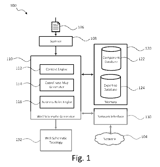
Figure 1 illustrates a block diagram of an exemplary computer system 100 for
aiding the
creation of digital representations of printed well schematics in accordance
with one or
more embodiments of the present disclosure. As shown in Figure 1, system 100
includes a
well schematic generator 110, a memory 120, and a network interface 130 so as
to enable a
source document 106 associated with an existing well to be utilized to
generate a well
schematic topology 132. Well schematic generator 110 includes a context engine
112,
coordinate map generator 114, and business rules engine 116. Memory 120 may be
used to
store a component database 122 and an expertise database 124. In an
embodiment, well
schematic generator 110 and its components (context engine 112, coordinate map
generator
114, and business rules engine 116), memory 120, and network interface 130 may
be
communicatively coupled to one another via, for example, an internal bus of
system 100.
4
CA 03003705 2018-04-30
WO 2017/095406
PCT/US2015/063493
In an embodiment, system 100 can be implemented using any type of computing
device
having one or more processors, a user input (for example, a mouse, QWERTY
keyboard,
touch-screen, a graphics tablet, or microphone), and a communications
infrastructure
capable of receiving and transmitting data over a network. Such a computing
device can
be, for example and without limitation, a mobile phone, a personal digital
assistant (PDA),
a tablet computer, a laptop computer, a desktop computer, a workstation, a
cluster of
computers, a set-top box, or other similar type of device capable of
processing instructions
and receiving and transmitting data to and from humans and other computing
devices.
Well schematic generator 110 and its modules (context engine 112, coordinate
map
generator 114, and business rules engine 116) can be implemented in software,
firmware,
hardware, or any combination thereof. Furthermore, embodiments of context
engine 112,
coordinate map generator 114, and business rules engine 116, or portions
thereof, can be
implemented to run on any type of processing device including, but not limited
to, a
computer, workstation, embedded system, networked device, mobile device, or
other type
of processor or computer system capable of carrying out the functionality
described herein.
As will be described in further detail below, memory 120 can be used to store
information
accessible by well schematic generator 110 for implementing the processes
described
herein. Memory 120 may be any type of recording medium coupled to an
integrated circuit
that controls access to the recording medium. The recording medium can be, for
example
and without limitation, a semiconductor memory, a hard disk, or other similar
type of
memory or storage device. Moreover, memory 120 may be integrated within system
100
or an external device communicatively coupled to system 100. In some
implementations,
memory 120 may be a remote cloud-based storage location communicatively
coupled to
system 100 over a network 104 via network interface 130.
Network 104 can be any type of network or combination of networks used to
communicate
information between different computing devices. Network 104 can include, but
is not
limited to, a wired (e.g., Ethernet) or a wireless (e.g., Wi-Fi and 3G)
network. In addition,
network 104 can include, but is not limited to, a local area network, medium
area network,
and/or wide area network such as the Internet.
Source document 106 may be a printed document or an electronic document that
contains
information about one or more wells. For example, a well may typically include
various
equipment such as casing strings, pipes, drilling assemblies, production
tubing, and other
5
CA 03003705 2018-04-30
WO 2017/095406
PCT/US2015/063493
drilling or production tools. The wellbore itself may be characterized by
various physical
characteristics such as diameters, lengths, deviation angles, materials of
construction such
as cement, etc., as well as environmental characteristics, such as formation
type, pressure,
temperature, porosity, permeability, etc. Accordingly, source document 106 may
contain
information about the wellbore, the formation in which the wellbore is formed,
and/or the
various equipment in the wellbore, all of which may be characterized as
components that
comprise the well. For example, in a particular well, surface and intermediate
casing may
be cemented into the wellbore, and production casing may be placed into the
wellbore.
An upper portion of the wellbore may be drilled at a first wellbore diameter
with casing of
a first casing diameter installed and cemented therein. A lower portion of the
wellbore
may be drilled at a second wellbore diameter smaller than the first wellbore
diameter, with
casing of a second casing diameter installed and cemented therein. The
wellbore is drilled
to its total depth (vertical, directional, or horizontal), with consecutively
decreasing
diameters with increasing total depth.
Various components of a well may be tools or other equipment deployed in the
well. A
non-limiting example of such components includes production casing, packers,
centralizers, slips, pumps, valves, crossover subs and gravel packs. Each of
these
components may have one or more physical and/or operational characteristics.
Additionally, a component may be associated with a particular commercial
product (e.g., a
particular brand of packer).
In one or more embodiments, one or more source documents 106 are collected,
the source
document(s) 106 containing one or more features associated with an existing
well. A
feature may be a text string and/or an image region. A text string may
describe, for
example, a well schematic component such as the wellbore's length, depth, or
diameter, a
tool's name, model, brand, etc. An image region may include, for example, a
symbol that
represents a well schematic component, such as a packer or production casing,
or an arrow
associated with a text string/symbol. In some examples, source document 106
may be
incomplete, may be of poor quality, or may contain erroneous information,
inaccurate
information, out-of-date information or ambiguous elements. For example,
source
document 106 may have been produced years earlier, by a different company
using a
manual process (e.g., drafting table or equivalent), and based on outdated
methodologies or
using obsolete equipment. For example, the nature of well schematics is that
they are
normally not drawn to scale. Vertical and horizontal scales may be different.
Moreover,
6
CA 03003705 2018-04-30
WO 2017/095406
PCT/US2015/063493
the vertical scale may be non-linear, and not logarithmic, as it may be based
on the
intensity and importance of the elements it has to represent along its path.
In any event, one or more source documents 106 are provided to well schematic
generator
110 for processing. If source document 106 is a printed document, a scanner
108 can be
used to digitize the printed source document and generate an electronic copy
of the source
document for processing by well schematic generator 110. In some examples, the
source
document 106 may be scanned into a Portable Document Format (PDF) and well
schematic
generator 110 may include a program (e.g., character text recognition) to read
the PDF
document. In some examples, well schematic generator 110 may include a program
that
performs character text recognition on source document 106 and provides a user
with the
number of times certain terms or words appear in source document 106. Well
schematic
generator 110 may also extract a list of words or terms from the document.
Well schematic generator 110 receives source document 106 as input and
processes it in
order to generate well schematic topology 132. Well schematic topology 132 is
a
schematic of a well and includes information about its components (e.g.,
materials of
construction, dimensions, equipment deployed in the well, etc.), as well as
information
pertaining to the hierarchical and geometric relationships among the
components. Context
engine 112, coordinate map generator 114, and business rules engine 116 may
process
source document 106 and compare it to data stored in component database 122
and/or
expertise database 124 to generate well schematic topology 132. These
databases may
store information about different types of wells and their components. Well
schematic
generator 110 may partition source document 106 into a coordinate map and
extract
features from the coordinate map that can be individually and collectively
compared to
data stored in component database 122 and/or expertise database 124.
Component database 122 includes one or more catalogued images. A catalogued
image
may represent a well schematic component. Figure 2 illustrates an example of
data stored
in component database 122 in accordance with one or more embodiments of the
present
disclosure. In Figure 2, a data table 200 is stored in component database 122
and includes
at least five catalogued images, and each of the images is mapped to its name.
For
example, an image 202 in a first row 204 of data table 200 represents a drill
collar, an
image 206 in a second row 208 of data table 200 represents a drill pipe, and
an image 210
in a third row 212 of data table 200 represents a packer. The images need not
be limited to
equipment within the well, but may represent the wellbore itself, such as
image 214 in a
7
CA 03003705 2018-04-30
WO 2017/095406
PCT/US2015/063493
fourth row 216 where a cross-section of the wellbore is depicted. In addition,
the images
may represent the formation in which the wellbore is drilled, such as image
218 in a fifth
row 220 where a particular type of formation is identified (e.g., sandstone).
Moreover, it
will be appreciated that in addition to equipment within the well, the images
may include
equipment at the wellhead or above the wellhead and deployed in association
with the well.
Expertise database 124 may include one or more business or well design rules
that may be
applied to a well schematic topology. A business rule may be that the diameter
of a well
decreases as the depth of the well increases. If a well schematic topology is
generated that
violates this rule, business rules engine 116 may make a determination about
the topology
in order to resolve the violation. For example, a determination may be made
that the well
schematic topology is upside down (if the diameter of the well consistently
increases as the
depth increases and all other business rules are satisfied) or that an error
has occurred (if a
first diameter above a second diameter of a well is larger than the second
diameter, but a
third diameter below the second diameter of the well is also larger than the
second
diameter). Based on the determination, a correction can be implemented in the
well
schematic topology in order to ensure the well schematic topology that is
generated
complies with the business rules of database 124.
Additionally, expertise database 124 may store information associated with
well schematic
components and/or the catalogued images stored in component database 122. For
example,
expertise database 124 may store product data, brochures, material properties
and other
physical or operational parameters of components, as well as cost information,
an
inventory of how many components are in stock, etc. Additionally, well
schematic
generator 110 may be trained to recognize various combinations of well
schematic
components. For example, well schematic generator 110 may identify a plurality
of well
schematic components that when presented together make up a particular well
schematic
component. For example, the individual components of a screen assembly, a
valve
assembly and two packers may be identified as a completion component.
Existing techniques for automatically generating or digitizing drawings rely
on a variety of
technologies, including image recognition, expert systems that search
documents for
images or text, and software libraries that are used to populate a blank
drawing canvas with
shapes that represent printed well schematic components. The present
disclosure combines
these existing technologies with techniques for inferring the design of a well
and its
components (e.g., casing, tubing, and drill strings) from context-based
graphical and
8
CA 03003705 2018-04-30
WO 2017/095406
PCT/US2015/063493
textual information contained in the source documents, obviating the need to
manually
input that data into expertise database 124 or component database 122 in order
to generate
a complete design schematic of a well.
With reference to Figures 3, 4, and 5, Figure 3 illustrates a process flow for
generating a
well schematic topology based on one or more source documents in accordance
with one or
more embodiments of the present disclosure. A source document 106, which is
illustrated
in Figure 4, may include text 140, images 142, or both associated with a
feature of the well.
Each feature, in turn, is associated with a component of a well. The
components of a well
might be anything associated with the well, including the tools or equipment
within a well
(or even at the surface), attributes of the wellbore itself, such as diameter
or length, or even
attributes of the formation in which the wellbore is drilled, such as the type
of rock around
a formation at a particular depth, porosity or permeability. Additionally,
features may be
nested. In some examples, a feature may also include one or more other
features. For
example, a feature may be an image, which may also contain other features,
such as text.
In any event, in one or more embodiments, certain text 140a may be presented
in proximity
to an image 142. Additionally, certain images 142a may establish connectivity
between
such text 140a and another proximate image 142b. Although the connectivity
image 142a
may be any image, in one or more embodiments, connectivity image 142a may be
an arrow
or line extending from the vicinity of text string 140a to the vicinity of
image 142b. The
text 140 and images 142 present data and information about one or more well
features to be
presented as well schematic components.
Referring back to Figure 3, coordinate map generator 114 receives source
document 106
and may partition it into cells to generate a coordinate map 310, which is
illustrated in
Figure 5. In one or more embodiments, the partition may be a grid formed of a
plurality of
cells. The grid may be an X-Y grid or some other coordinate system. It will be
appreciated that the level of gradation or size of the cells may be adjusted
as necessary to
refine the procedures described herein. In any event, within each cell, the
coordinate map
generator 114 identifies text 140 and images 142 within the source document
106 and
extracts them as a set of text strings 302 and a set of image regions 304,
which are stored in
coordinate map 310. In other words, coordinate map generator 114 may generate
coordinate map 310 including a set of text strings 302 and a set of image
regions 304
derived from source document 106. As such, coordinate map generator 114 may
define the
image regions and text strings generated from the extracted data from source
document
9
CA 03003705 2018-04-30
WO 2017/095406
PCT/US2015/063493
106. In some embodiments, coordinate map generator 114 uses a robot
navigational
technique to parse and reconstruct engineering drawings from low-quality
printed sources.
Coordinate map 310 may be used to aid in generating a well schematic topology
of a well.
In Figure 5, coordinate map 310 illustrates an X-Y coordinate system having 42
cells and
includes the features contained in source document 106 illustrated in Figure
4. As shown
in Figure 5, cells 502-505 and 514 and 515 contain only text strings, while
cells 512 and
518 contain only image regions. Cell 513 contains both an image region and a
text string.
Context engine 112 may receive coordinate map 310 as an input and associate
one or more
text strings of set of text strings 302 with one or more image regions of set
of image
regions 304. An image region may include one or more image patterns. Context
engine
112 may perform pattern matching techniques to each defined image region in
order to
identify features. In one or more embodiments, context engine 112 may include
a program
that is able to gauge a deeper context of text 140 in source document 106.
Thus, in one or
more embodiments, context engine 112 may include a semantics engine (not
shown) that
parses one or more sentences in source document 106 and understands its
meaning.
Likewise, in one or more embodiments, context engine 112 may include an image
recognition engine that searches and identifies particular shapes in an image.
Context
engine 112 may identify individual segments of an image region corresponding
to wellbore
components for which additional information is desired (e.g., a piece of
tubing, internal
control valve, etc. in a well). It may be unnecessary for the contextual
information (e.g.,
text labels, dimensions, depth markers, or component images) to be stored in a
predetermined database format. Context engine 112 may compare the features in
coordinate map 310 with the data in component database 122, which stores one
or more
catalogued images that represent well schematic components. For each image
region,
context engine 112 may search component database 122 using a combination of
image
pattern and associated text strings from coordinate map 310.
Context engine 112 may associate a first feature with a second feature in
coordinate map
310. For example, context engine 112 may associate a text string of set of
text strings 302
with an image region of set of image regions 304. The association between the
text string
and the image region may be based on a context of the text string in
coordinate map 310.
In one or more embodiments, context engine 112 determines a distance between
one or
more text strings and one or more image regions in coordinate map 310, where
the context
includes a distance between the text string and the image region in the
coordinate map.
CA 03003705 2018-04-30
WO 2017/095406
PCT/US2015/063493
Context engine 112 may utilize a connectivity image 142a to establish an
association
between a first feature, such as text 140a, and a second feature, such as
image 142a. In
other embodiments, context engine 112 may count the number of image regions
and apply
a clustering algorithm to associate one or more text strings with one or more
image regions
included in coordinate map 310. A first text string that is closer to an image
region
compared to a second text string may have a higher probability of being
associated with the
image region compared to the second text string, although this may not always
be the case.
For example, in some cases, even though the second text string is farther from
the image
region than the first text string, the second text string may be associated
with an image
region, as described above, using a connectivity image 142a or other means of
association.
As an example, context engine 112 may identify an arrow or line included in an
image
region and associated with a dimension of a well schematic component. Context
engine
112 may determine the component to which the dimension corresponds and may
associate
the dimension (e.g., text string) with the image region including the
component to which
the dimension corresponds.
In Figure 5, a lower portion of image region 502 includes a text string
"Casing" and a
lower portion of image region 504 includes a text string "Depth (mDDbrt)."
Additionally,
image region 503, which is adjacent image region 502, includes text strings
"28", "18-
5/8", "13-3/8'"', "10-3/4"X0", "9 5/8", "7" TOL", and "7'"', and image region
505,
which is adjacent image region 504, includes text strings "11.0", "100.0",
"715.0",
"103.0", "2091.0" "1937" and "2283". Context engine 112 may recognize that the
text
strings "28", "18-5/8", "13-3/8', "10-3/4" XO", "9 5/8", "7" TOL", and "7" are
below, but proximate to text string "Casing" and that the text strings "11.0",
"100.0",
"716.0", "103.0", "2091.0" "1987" and "2283" are below, but proximate to text
string
"Depth" so as to be connected, respectively. In this regard, context engine
112 may
recognize that in addition to being proximate one another, the respective text
is arranged in
a particular manner. For example, "casing" column aligns with the "Depth"
column and
that the text strings in image region 503 and 505 contain equal length lists.
Context engine
112 may determine that these text strings correspond to each other and
identify with which
particular feature(s) (e.g., casing) the text strings in the "Depth" column
are associated.
For example, context engine 112 may determine, based on the context of these
text strings
in coordinate map 310, that the first text string below "Casing" corresponds
to the first text
string below "Depth" (e.g., the 28" casing string is located at a depth of
11.0 mDDbrt), the
CA 03003705 2018-04-30
WO 2017/095406
PCT/US2015/063493
second text string below "Casing" corresponds to the second text string below
"Depth"
(e.g., the 118-5/8" casing string is located at a depth of 100.0 mDDbrt), and
soon.
Context engine 112 may maintain context information in a context database 320.
Context
database 320 may include associations and relationships between features in
one or more
external coordinate maps, as well as associations and relationships between
features in
coordinate map 310. Context database 320 may be used to determine context as
described
above based on comparison with associations and relationships derived from
external
coordinate maps. Moreover, context engine 112 may identify features in
coordinate map
310 and store them as (key, value) pairs. For example, context engine 112 may
map each
string in image region 503 to an adjacent string in image region 505.
Figure 6 illustrates an example of a two-column data table 600 that is
produced by context
engine 112 in accordance with one or more embodiments of the present
disclosure by
establishing context between each of cells 502, 503, 504 and 505 from Figure
5. Data table
600 may be stored in context database 320 and indicates that a 28" casing
string is at a
depth of 11.0 mDDbrt, a 18-5/8" casing string is at a depth of 100.0 mDDbrt,
and so on.
The particular casing strings may be in a wellbore at those indicated depths.
In the
illustrated embodiment of Figure 6, context engine 112 establishes that the
text casing
appearing in the lower portion of cell 502 is in proximity to the text "28" in
the upper
portion of adjacent cell 503. Moreover, context engine 112 established that
all of the text
in cell 503 is aligned in a column to suggest that "casing" as shown in cell
502 is
associated with the column. Additionally, context engine 112 likewise
established the
foregoing for the "Depth" column. Finally, context engine 112 establishes a
relationship
between the two columns. Specifically, the text in the lower portion of cell
502 is
positioned in the same location as the text in the lower portion of adjacent
cell 504, and the
text in cell 503 is positioned in the same relative position as the text in
adjacent cell 505,
thereby indicating that the column in cells 502 and 503 are related to the
column in cells
504 and 505. In some examples, context engine 112 extracts a unit of
measurement
(UOM) from coordinate map 310 or data table 600 and converts the UOM into
another
form. For example, context engine 112 may extract the UOM "inches" from data
table 600
or coordinate map 310, convert the fractional values into decimal values, and
compute the
length of each known casing string listed in data table 600. Likewise, units
of
measurement may be converted between systems of measurement, such as feet to
meters.
12
CA 03003705 2018-04-30
WO 2017/095406
PCT/US2015/063493
Referring back to Figure 5, context engine 112 may recognize that a feature in
image
region 512 is associated with one or more text strings in image regions 513-
515. Context
engine 112 may parse the text in image regions 513-515, extract the depth
"2092 mDDbrt,"
and map these features to known key-value pair <"Casing: 9 5/8", 2091.0> from
the
previous region mapping (see data table 600). Context engine 112 may insert
this
association information into context database 320. Accordingly, a result may
be a
topological marker of the end of the casing string that may be used to place
other well
features in their correct positions relative to that casing string. Although
the depth
"2091.0" as indicated in the text string in cell 505 may be inconsistent with
the depth
"2092 mDDbrt" as indicated in the text string in cell 514, context engine 112
may have the
intelligence to associate the "2091.0" text string in cell 505 with the "2092
mDDbrt" text
string in cell 514 because the "2092 mDDbrt" text string in cell 514 is in
close proximity to
the text string "9 5/8" in cell 513. The text string "9 5/8" in cell 513 may
correspond with
the text string "9 5/8" in cell 503.
It should be understood that these are merely examples of associations and
contextual
information that may be identified by context engine 112, and context engine
112 may
store additional information associated with coordinate map 310 or other
coordinate maps
into context database 320. Additionally, it should be understood that although
source
document 106 is illustrated as being partitioned using an X-Y grid, this is
not intended to
be limiting. Additionally, one or more of the image regions in source document
106 may
be of different sizes.
In some embodiments, context engine 112 links one or more image regions of set
of image
regions 304 with a corresponding catalogued image stored in component database
122. For
example, image region 518 includes image 210 (see Figure 2), which represents
a packer.
Accordingly, context engine 112 may identify image region 518 (which contains
image
210) and link image region 518 with corresponding catalogued image 210 stored
in
component database 122. Context engine 112 may link one or more image regions
of set
of image regions 304 with a corresponding catalogued image stored in component
database
122 by comparing one or more image regions with catalogued images stored in
component
database 122. Context engine 112 may determine, based on the one or more
comparisons,
whether an image region and a catalogued image stored in component database
122 satisfy
a correlation threshold. An image region and a catalogued image may satisfy
the
correlation threshold if their similarities to each other are above the
correlation threshold.
13
CA 03003705 2018-04-30
WO 2017/095406
PCT/US2015/063493
For example, context engine 112 may detect an image of an object having more
rings than
the number of rings illustrated in image 202 of Figure 2. Although the object
has more
rings than the number of rings illustrated in image 202, context engine 112
may compare
the image region including the object with catalogued image 202 and determine
that they
satisfy the correlation threshold. The library of images stored in component
database 122
may evolve over time. In some examples, a drill collar may have multiple
images in
component database 122 associated with the drill collar. In some examples, the
correlation
threshold and identification rules may be modified as new exceptions arise.
Context engine 112 may link an image region with a catalogued image in
response to a
determination that the image region and the catalogued image satisfy the
correlation
threshold. In some examples, context engine 112 applies a regression analysis
to
determine whether the image region and catalogued image satisfy the
correlation threshold.
In an example, context engine 112 may determine whether the image region
includes the
catalogued image. In this example, if the image region includes the catalogued
image, the
image region and catalogued image satisfy the correlation threshold. In
another example,
if an image region includes an image that has similar features to that
included in a
catalogued image, the image region and the catalogued image satisfy the
correlation
threshold.
In some examples, a user may identify an image region in coordinate map 310
and
recognize one or more well schematic components in the image region. For
example, the
user may identify an interval control valve in an image region and determine
that it is of a
brand "ABC" by looking at the text associated with the interval control valve
in coordinate
map 310. The user may instruct context engine 112 to add the image region with
metadata
(e.g., brand "ABC") corresponding to the associated text string (e.g.,
interval control value)
to component database 122, create a label for the new image region, and mark
it as
satisfying the correlation threshold. Context engine 112 may determine that
the image
region and catalogued image satisfy the correlation threshold and store a
component
identifier (TD) of the well schematic component into coordinate map 310 at the
image
region location. The well schematic component may be assigned a component ID
that is
used to place it properly in well schematic topology 322. A component ID is
unique to the
well and is used to form the parent-child relationship in well schematic
topology 322 and
indicates a set of instructions on how to build the well. For example, a first
component
assigned a first component ID may be at a lower depth in well schematic
topology 322 than
14
CA 03003705 2018-04-30
WO 2017/095406
PCT/US2015/063493
a second component assigned a second component ID because the first component
ID is
less than the second component ID.
One or more regions of set of image regions 304 may be made successively
smaller or
larger in order to capture features of different sizes. In some examples, an
image region
may be further partitioned into smaller image regions. For example, if none of
the features
in an image region matches data (e.g., an image) stored in component database
122,
context engine 112 may further partition the image region into smaller image
regions until
the image region reaches a size threshold and/or until context engine 112
identifies features
within the image region that match data in component database 122. In some
examples,
context engine 112 may identify features included in an image region and
further zoom
into the image region to identify additional &a-Wires. For example, context
engine 112 may
further partition an image region of a coordinate map 310 into smaller image
regions to
recognize text strings located near identified features. For example, context
engine 112
may mom in and identify a pump in a coordinate map and may further zoom into
the pump
to identify a brand of the pump.
Context engine 112 may generate well schematic topology 322 in accordance with
coordinate map 310 and the one or more catalogued images linked with one or
more image
regions. Well schematic topology 322 may be based on data stored in component
database
122 and coordinate map 310. Well schematic topology 322 may be an image of a
wellbore, its components, and/or information about the components (e.g.,
depth, material,
etc.).
Referring back to Figure 3, business rules engine 116 may use well schematic
topology
322 as an input and update it in accordance with one or more business rules.
Business
rules engine 116 may search expertise database 124 for one or more business
rules to apply
to well schematic topology 322. Expertise database 124 may include information
about
wells. For example, expertise database 124 may store information about the
proper
maintenance of particular types of wells. Expertise database 124 may be a
virtual database
that stores information from heterogeneous sources (e.g., email applications,
word
applications, drawing applications, etc.). In some examples, expertise
database 124 stores
the information into data tables based on different data models. For example,
extensible
markup language (XML) may be used to describe data and create a "well" data
type. Each
well has at least one wellbore, which itself has at least one casing string
and at least one
cemented region. This information may be used to create a "well" data type
that includes a
CA 03003705 2018-04-30
WO 2017/095406
PCT/US2015/063493
field for the casing string and cemented region, and this information may be
mapped to
expertise database 124. Business rules engine 116 may fill in the fields based
on
information from expertise database 124 and well schematic topology 322.
Additional
information may be added to expertise database 124 to update the "well" data
type and
create other data types. The information in expertise database 124 may be
updated in order
to train the system to provide the most up-to-date recommendations and
information about
wells. For example, contextually available pieces of information based on
image
recognition or the most up-to-date well building practices may be stored in
expertise
database 124.
In some examples, business rules engine 116 may process well schematic
topology 322 and
perform a strength assessment of the well described in well schematic topology
322. For
example, business rules engine 116 may provide a live interaction description
of the well
that draws upon actual material and product specifications that are known for
the types of
equipment of which the well is composed. For example, business rules engine
116 may
identify the year in which the well was built and search expertise database
124 for
information specific to wells built in that particular year. Business rules
engine 116 may
then apply the appropriate business rules for the well. In some examples,
expertise
database 124 stores a library of well types and the wellbore components that
make up each
well type. In an example, coordinate map 210 includes the text string "Year
1990" and
context engine 112 determines based on this text string and other information
in coordinate
map 310 that the well was built in 1990. Context engine 112 may pass this
information
along to business rules engine 116. Based on one or more business rules stored
in
expertise database 124 and the thickness of a production casing specified in
well schematic
topology 322, business rules engine 116 may determine that the casing in the
well is made
of a particular type of steel, that corrosion of the steel has probably
progressed to a certain
point, and provide a recommendation about the integrity of the well to the
user. Business
rules engine 116 may provide the user with the particular steel properties and
design
considerations and maintenance procedures that should be taken into account
given the
steel's properties.
Business rules engine 116 may sort set of image regions 204 into an order that
is based on
a design sequence for building a well and update well schematic topology 322
based on the
sorted set of image regions. In some examples, expertise database 124 stores a
library of
the best design practices for building a well. If a part of source document
106 is missing or
16
CA 03003705 2018-04-30
WO 2017/(1954(16
PCT/US2015/063493
obscured, well schematic topology 322 may also be missing well schematic
components or
other important information. Business rules engine 116 may be able to identify
the missing
components by knowing that the particular well being described by well
schematic
topology 322 typically has a first component at a first depth, a second
component at a
second depth, and so on. Accordingly, even if source document 106 does not
contain the
first or second component, business rules engine 116 may include the missing
component(s) in updated well schematic topology 324 based on the best
practices specified
in expertise database 124. In an example, business rules engine 116 determines
whether a
subset of image regions includes a first set of design components that
satisfies a design
threshold. In response to a determination that the first set of design
components does not
satisfy the design threshold, business rules engine 116 may determine a second
set of
design components missing from the subset of image regions and update well
schematic
topology 322 by adding the second set of design components to the well
schematic
topology. In this example, updated well schematic topology 324 includes the
second set of
design components. A representation of the second set of design components may
be
stored in component database 122 or expertise database 124, and business rules
engine 116
may add the missing well schematic component(s) to well schematic topology 322
to
generate updated well schematic topology 324.
In some examples, business rules engine 116 may determine that a well
schematic typically
has the conductor casing at the top of the well, the intermediate casing at
the middle of the
well, the production casing at the bottom of the well, and production tubing
along a vertical
plane of the well. Business rules engine 116 may create and/or confirm the
dimensions of
the well and update well schematic topology 322 by placing the individual well
schematic
components in well schematic topology 224 in the proper locations based on the
knowledge of how particular components are typically put together to make it a
consistent
system. For example, if well schematic topology 322 is upside down and
provided as input
into business rules engine 116 as such, business rules engine 116 may
recognize that well
schematic topology 322 is upside down and would not build the well schematic
topology
upside down. For example, business rules engine 116 may recognize that a well
cannot
start out with a small production bore and large diameter conductor hole at
the bottom of
the well. Rather, business rules engine 116 may re-organize the components
illustrated in
well schematic topology 322 such that the components are in their proper
locations.
17
CA 03003705 2018-04-30
WO 2017/095406
PCT/US2015/063493
Additionally, business rules engine 116 may recognize that if a packer is
deployed in a
wellbore, there is a high probability that an outer casing is deployed in and
disposed around
an inner tubular of the well to fill the annulus. Accordingly, if business
rules engine 116
identifies a packer in well schematic topology 322, business rules engine 116
may also
look for information about the outer casing.
In some examples, business rules engine 116 may parse the data in well
schematic
topology 322 and determine whether additional information should be included
in well
schematic topology 322. Business rules engine 116 may identify parts of the
well
described in well schematic topology 322 and place it into context through
additional
analysis using expertise database 124. Accordingly, business rules engine 116
may
provide the user with a deeper understanding of the well described in well
schematic
topology 322 by updating it with more information. For example, well schematic
topology
322 may include a representation of a pump and business rules engine 116 may
find
information about the pump in expertise database 124 to provide the user with
additional
information about the pump. In this example, business rules engine 116 may
inform the
user when the pump was last serviced, the cost of installing the pump, the
brand of the
pump, the model number of the pump, etc. Business rules engine 116 may
determine that
the company bought 10 of these pumps in year 2012 and that the pump listed in
well
schematic topology 322 was serviced 5 years ago and has 6 months of useful
life. Based
on this information, the user may submit a service request for inspection of
the well and
note that this particular pump has an additional 6 months of useful life left.
Accordingly,
rather than the user attempting to locate information about this particular
pump by sifting
through hard files in the company, business rules engine 116 may bring up its
associated
information and provide a context of the well and in particular this pump to
the user.
Business rules engine 116 provides more detailed information about individual
well
schematic components (reports, product data, etc.) to the user. The user may
interact
(hover, click, etc.) with well schematic components on a viewing device, such
as a
computer screen, and the schematic component can be associated with product
catalog data
(using context-based text information or image recognition). In some examples,
business
rules engine 116 links a well schematic component in well schematic topology
322 to
product data about the well schematic component and updates well schematic
topology 322
by providing a reference to the product data in updated well schematic
topology 324. In
some examples, business rules engine 116 links a well schematic component in
well
18
CA 03003705 2018-04-30
WO 2017/095406
PCT/US2015/063493
schematic topology 322 to product data about the well schematic component and
updates
well schematic topology 322 by providing the product data in updated well
schematic
topology 324.
In an example, business rules engine 116 may recognize that a packer included
in image
region 518 is of brand "ABC." Accordingly, business rules engine 116 may point
a
browser (not shown) to ABC's website. Business rules engine 116 may determine
the
packer's brand based on image recognition or the text string "ABC" near the
packer. The
browser may execute on the computing device on which well schematic generator
110 is
executing. From the website, business rules engine 116 may be able to
determine the
packer's true dimensions, its cost, its material composition, the materials
with which the
packer is compatible, useful life, etc. This information may be provided to
the user via a
display. Accordingly, the user may become aware if the packer is approaching
the end of
its useful life and should be replaced. If the user determines that the packer
should be
replaced soon, the user may order the packer from ABC and schedule a work
order for this
well. If the user were not aware that the packer was approaching the end of
its useful life,
the well may end up with a leak or a failure that may be expensive and time
consuming to
fix.
As discussed above and further emphasized here, Figures 1-6 are merely
examples, which
should not unduly limit the scope of the claims. For example, although
coordinate map
generator 114 is described as generating a coordinate map based on a source
document
including a set of text strings and a set of image regions, it should be
understood that
coordinate map generator 114 may generate a coordinate map based on a source
document
including only a set of text strings or generate a coordinate map based on a
source
document including only a set of image regions.
Additionally, although well schematic topology 322 is described as being based
on one
coordinate map (e.g., coordinate map 310) and one or more catalogued images
linked with
one or more image regions included in the coordinate map, this is not intended
to be
limiting and it should be understood that well schematic topology 322 may be
based on a
plurality of coordinate maps. For example, context engine 112 may store
associations
between text strings and image regions from multiple coordinate maps in
component
database 122 and then generate well schematic topology 322 based on
information from
different coordinate maps. Figure 7 illustrates a block diagram 700 of context
engine 112
collecting information from multiple coordinate maps and generating well
schematic
19
CA 03003705 2018-04-30
WO 2017/095406
PCT/US2015/063493
topology 322 based on a plurality of coordinate maps and data stored in
component
database 122. In Figure 7, coordinate map 702 stores a set of text strings
704. Coordinate
map generator 114 may store set of text strings 704 into coordinate map 702.
In some
examples, context engine 112 associates one or more text strings of set of
text strings 704
with one or more image regions of set of image regions 304. A text string of
set of text
strings 704 may be associated with an image region of set of image regions 304
based on a
context of the text string in coordinate map 702 and/or based on a context of
the image
region in coordinate map 310. Context engine 112 may link one or more image
regions of
set of image regions 304 with a corresponding catalogued image stored in
component
database 122. Context engine 112 may further generate well schematic topology
322 in
accordance with the one or more catalogued images linked with the one or more
image
regions of set of image regions 304, coordinate map 310, and/or coordinate map
702.
Additionally, coordinate map 706 stores a set of image regions 708. Coordinate
map
generator 114 may store set of image regions 708 into coordinate map 706. In
some
examples, context engine 112 associates one or more text strings of set of
text strings 302
with one or more image regions of set of image regions 708. A text string of
set of text
strings 302 may be associated with an image region of set of image regions 708
based on a
context of the text string in coordinate map 310 and/or based on a context of
the image
region in coordinate map 706. Context engine 112 may link one or more image
regions of
the set of image regions 708 with a corresponding catalogued image stored in
component
database 122. Context engine 112 may further generate well schematic topology
322 in
accordance with the one or more catalogued images linked with the one or more
image
regions of set of image regions 708, coordinate map 310, and/or coordinate map
706.
Additionally, coordinate map 712 stores a set of text strings 714 and a set of
image regions
716. Coordinate map generator 114 may store set of text strings 714 and set of
image
regions 716 into coordinate map 712. In some examples, context engine 112
associates
one or more text strings of set of text strings 714 with one or more image
regions of set of
image regions 304. A text string of set of text strings 714 may be associated
with an image
region of set of image regions 304 based on a context of the text string in
coordinate map
712 and/or based on a context of the image region in coordinate map 310. In
some
examples, context engine 112 associates one or more image regions of set of
image regions
716 with one or more text strings of set of text strings 302. A text string of
set of text
strings 302 may be associated with an image region of set of image regions 716
based on a
CA 03003705 2018-04-30
WO 2017/095406
PCT/US2015/063493
context of the text string in coordinate map 310 and/or based on a context of
the image
region in coordinate map 712. Context engine 112 may link one or more image
regions of
set of image regions 716 with a corresponding catalogued image stored in
component
database 122. Context engine 112 may generate well schematic topology 322 in
accordance with the one or more catalogued images linked with the one or more
image
regions of image regions 716, coordinate map 310, and/or coordinate map 712.
In some
examples, context engine 112 may generate well schematic topology 322 based on
data
stored in component database 122, coordinate map 310, coordinate map 702,
coordinate
map 706, and/or coordinate map 712.
Figure 8 is a process flowchart of an exemplary method 800 of providing a
digital
representation of a well schematic in accordance with one or more embodiments.
Method
800 is not meant to be limiting and may be used in other applications. As
shown in Figure
8, method 800 includes steps 802, 804, 806, 808, and 810. For discussion
purposes,
method 800 will be described using computer system 100 of Figure 1, as
described above.
However, method 800 is not intended to be limited thereto.
Method 800 includes a step 802, which includes storing a set of text strings
and a set of
image regions into a coordinate map. In an example, coordinate map generator
114 stores
set of text strings 302 and set of image regions 304 into coordinate map 310.
In a step 804,
one or more text strings of the set of text strings is associated with one or
more image
regions of the set of image regions, where a text string is associated with an
image region
based on a context of the text string in the coordinate map. In an example,
context engine
112 associates one or more text strings of set of text strings 302 with one or
more image
regions of set of image regions 304, where a text string is associated with an
image region
based on a context of the text string in coordinate map 310.
In a step 806, one or more first image regions of the set of image regions is
linked with a
corresponding catalogued image stored in a component database, where the
catalogued
image represents a well schematic component. In an example, context engine 112
links
one or more first image regions of set of image regions 304 with a
corresponding
catalogued image stored in component database 122, where the catalogued image
represents a well schematic component (e.g., casing string, packer, etc.).
In a step 808, a well schematic topology is generated in accordance with the
coordinate
map and the one or more catalogued images linked with the one or more first
image
21
CA 03003705 2018-04-30
WO 2017/095406
PCT/US2015/063493
regions. In an example, context engine 112 generates well schematic topology
322 in
accordance with coordinate map 310 and the one or more catalogued images
linked with
the one or more image regions of set of image regions 304. In a step 810, the
well
schematic topology is updated in accordance with one or more business rules.
In an
example, business wiles engine 116 updates well schematic topology 322 in
accordance
with one or more business rules stored in expertise database 124.
It is understood that additional processes may be inserted before, during, or
after steps 802,
804, 806, 808, and 810 discussed above. It is also understood that one or more
of the steps
of method 800 described herein may be omitted, combined, or performed in a
different
sequence as desired.
Figure 9 is a process flowchart of an exemplary method 900 of providing a
digital
representation of a well schematic in accordance with one or more embodiments.
Method
900 is not meant to be limiting and may be used in other applications. As
shown in Figure
9, method 900 includes steps 902, 904, 906, 908, 910, 912, 914, 916, 918, and
920. For
discussion purposes, method 900 will be described using computer system 100 of
Figure 1,
as described above. However, method 900 is not intended to be limited thereto.
Method 900 includes a step 902, which includes scanning a printed source
document. In
an example, the user scans in source document 106 using scanner 108. In a step
904, the
digitized document is parsed for one or more text strings. In an example,
coordinate map
generator 114 parses the digitized source document for one or more text
strings. In a step
906, one or more text strings is identified and stored into a coordinate map.
In an example,
coordinate map generator 114 stores one or more identified text strings into
coordinate map
310.
In a step 908, image regions are defined within the source document. In an
example,
coordinate map generator 114 defines the image regions within source document
106. In
some examples, coordinate map 310 is the source document partitioned by a
grid. In a step
910, the image regions in the coordinate map are counted and associated with
the one or
more identified text strings. In an example, context engine 112 counts the
image regions in
coordinate map 310 and associates the one or more identified text strings with
the image
regions. In a step 912, the image regions are mapped to one or more well
schematic
components represented in a well. In an example, context engine 112 maps the
image
regions to one or more well schematic components represented in a well.
22
CA 03003705 2018-04-30
WO 2017/095406
PCT/US2015/063493
In a step 914, a well schematic topology is created from the mapped image
regions. In an
example, context engine 112 creates well schematic topology 322 from the
mapped image
regions. For example, context engine 112 may create well schematic topology
322 from
the image regions mapped to catalogued images in component database 122 and
stored in
context database 320. In a step 916, the well schematic topology is compared
to data
stored in an expertise database. In an example, business rules engine 116
compares well
schematic topology 322 to data stored in expertise database 124. In some
examples,
business rules engine 116 compares well schematic topology 322 to data stored
in expertise
database 124 by applying a regression algorithm to identify image regions and
catalogued
images that satisfy the correlation threshold. In some examples, business
rules engine 116
adds well schematic components from component database 122 to fill in gaps
between well
schematic topology 322 and in accordance with a particular design sequence for
building a
well.
In a step 918, the well schematic topology is updated based on the
comparison(s). In an
example, business rules engine 116 updates well schematic topology 322 based
on the
comparison(s). In a step 920, the updated well schematic topology is provided
to a user.
In an example, business rules engine 116 provides well schematic topology 224
to a user,
where well schematic topology 224 is an updated version of well schematic
topology 322.
It is understood that additional processes may be inserted before, during, or
after steps 902,
904, 906, 908, 910, 912, 914, 916, 918, and 920 discussed above. It is also
understood that
one or more of the steps of method 900 described herein may be omitted,
combined, or
performed in a different sequence as desired.
For example, Figure 10 is a process flowchart of an exemplary method 1000 of
storing a
component identifier (ID) in a coordinate map in accordance with one or more
embodiments. Method 1000 is not meant to be limiting and may be used in other
applications. As shown in Figure 10, method 1000 includes steps 910, 1002,
1004, 1006,
1008, 1010, 1012, and 914. For discussion purposes, method 1000 will be
described using
computer system 100 of Figure 1, as described above. However, method 1000 is
not
intended to be limited thereto.
In method 1000, process flow proceeds from step 910 to a step 1002, which
includes
searching a component database using a combination of image regions and
associated text
strings. In an example, context engine 112 searches component database 122
using a
23
CA 03003705 2018-04-30
WO 2017/095406
PCT/US2015/063493
combination of image regions of set of image regions 204 and associated text
strings. In a
step 1004, it is determined whether an image region and a catalogued image
stored in the
component database satisfy a correlation threshold, where the catalogued image
represents
a well schematic component. In an example, context engine 112 determines
whether an
image region of set of image regions 204 and a catalogued image stored in
component
database 122 satisfy a correlation threshold, where the catalogued image
represents a well
schematic component.
In response to a determination that an image region and a catalogued image
stored in the
component database do not satisfy the correlation threshold, process flow
proceeds from
step 1004 to a step 1006, in which the image region is added to the component
database
with metadata corresponding to the associated text. In an example, in response
to a
determination that an image region and a catalogued image stored in component
database
122 do not satisfy the correlation threshold, context engine 112 adds the
image region to
component database 122 with metadata corresponding to the associated text. In
a step
1008, a label for the image region is created and the image region and the
catalogued
image are marked as satisfying the correlation threshold. In an example,
context engine
112 creates a label for the image region and marks the image region and the
catalogued
image as satisfying the correlation threshold. In this example, context engine
112 may
store the label in context database 320. Process flow may proceed from step
1008 to a step
1010.
In response to a determination that an image region and a catalogued image
stored in the
component database satisfy the correlation threshold, process flow proceeds
from step
1004 to step 1010, in which the image region and the catalogued image are
linked. In an
example, in response to a determination that an image region and a catalogued
image
stored in component database 122 satisfy the correlation threshold, context
engine 112
links the image region and the catalogued image. In a step 1012, a component
ID is stored
in the coordinate map of the image region location, where the component ID
identifies a
corresponding well schematic component. In an example, context engine 112
stores a
component ID in coordinate map 310 of the image region location, where the
component
ID identifies a corresponding well schematic component. Process flow proceeds
from step
1012 to step 914, in which a well schematic topology is created from the
mapped image
regions.
24
CA 03003705 2018-04-30
WO 2017/095406
PCT/US2015/063493
It is understood that additional processes may be inserted before, during, or
after steps 910,
1002, 1004, 1006, 1008, 1010, 1012, and 914 discussed above. It is also
understood that
one or more of the steps of method 1000 described herein may be omitted,
combined, or
performed in a different sequence as desired. In some embodiments, one or more
of steps
1002, 1004, 1006, 1008, 1010, and/or 1012 may be performed for any number of
image
regions in a coordinate map.
Figure 11 is a process flowchart of an exemplary method 1100 of linking a well
schematic
component to associated product data in accordance with one or more
embodiments.
Method 1100 is not meant to be limiting and may be used in other applications.
As shown
in Figure 11, method 1100 includes steps 916, 1102, 1104, 1106, 1108, 1110,
and 920. For
discussion purposes, method 1100 will be described using computer system 100
of Figure
1, as described above. However, method 1100 is not intended to be limited
thereto.
In method 1100, process flow proceeds from step 916 to a step 1102, in which a
component database is searched using a component ED and one or more text
strings
associated with a catalogued image, where the component ID identifies a
corresponding
well schematic component in the component database. In an example, business
rules
engine 116 searches component database 122 using a component ID and one or
more text
strings associated with a catalogued image, where the component ID identifies
a
corresponding well schematic component in component database 122. In a step
1104, it is
determined whether an image region and a catalogued image identified by the
component
ID satisfy a correlation threshold, where the catalogued image represents a
well schematic
component. In an example, context engine 112 determines whether an image
region of set
of image regions 204 and a catalogued image identified by the component ID
satisfy a
correlation threshold, where the catalogued image represents a well schematic
component.
In response to a determination that an image region and a catalogued image
identified by
the component ID do not satisfy the correlation threshold, process flow
proceeds from step
1104 to a step 1106, in which a product identifier that identifies the well
schematic
component is assigned a NULL value. In an example, in response to a
determination that
an image region and a catalogued image identified by the component ID do not
satisfy the
correlation threshold, business rules engine 116 assigns a NULL value to a
product
identifier that identifies the well schematic component. If a NULL value is
newly assigned
to a product identifier that identifies the well schematic component, it may
be desirable to
provide a subject matter expert with a visual inspection of the well schematic
component.
CA 03003705 2018-04-30
WO 2017/095406
PCT/US2015/063493
For example, a message may be sent to the subject matter expert, where the
message
includes the image region or an image of the particular well schematic
component and a
request for the subject matter expert to classify the component. Rules (e.g.,
in component
database 122 or context database 320 or expertise database 124) may be amended
based on
the subject matter expert's input so that the system may properly identify the
component if
the image included in the image region is encountered again.
In response to a determination that an image region and a catalogued image
identified by
the component ID satisfy the correlation threshold, process flow proceeds from
step 1104
to a step 1108, in which the product identifier is assigned to the well
schematic component
represented by the catalogued image. In an example, in response to a
determination that an
image region and a catalogued image identified by the component ID satisfy the
correlation
threshold, business rules engine 116 assigns the product identifier to the
well schematic
component represented by the catalogued image. In a step 1110, the well
schematic
component is linked to product data associated with the product identifier. In
an example,
business rules engine 116 links the well schematic component to product data
associated
with the product identifier. Process flow proceeds from step 1110 to step 920,
in which the
updated well schematic topology is provided to the user.
It is understood that additional processes may be inserted before, during, or
after steps 916,
1102, 1104, 1106, 1108, 1110, and 920 discussed above. It is also understood
that one or
more of the steps of method 1100 described herein may be omitted, combined, or
performed in a different sequence as desired. In some embodiments, one or more
of steps
1102, 1104, 1106, 1108, and/or 1110 may be performed for any number of image
regions
in a coordinate map.
Figure 12 is a block diagram of an exemplary computer system 1200 in which
embodiments may be implemented. System 1200 can be a workstation, a laptop
computer,
a tablet computer, a server computer, a smartphone, and/or the like, or any
other type of
electronic device. Such an electronic device includes various types of
computer readable
media and interfaces for various other types of computer readable media. As
shown in
Figure 12, system 1200 includes a permanent storage device 1202, a system
memory 1204,
an output device interface 1206, a system communications bus 1208, a mad-only
memory
(ROM) 1210, processing unit(s) 1212, an input device interface 1214, and a
network
interface 1216.
26
CA 03003705 2018-04-30
WO 2017/095406
PCT/US2015/063493
Bus 1208 collectively represents all system, peripheral, and chipset buses
that
communicatively connect the numerous internal devices of system 1200. For
instance, bus
1208 communicatively connects processing unit(s) 1212 with ROM 1210, system
memory
1204, and permanent storage device 1202.
From these various memory units, processing unit(s) 1212 retrieves
instructions to execute
and data to process in order to execute the processes of the subject
disclosure. The
processing unit(s) can be a single processor or a multi-core processor in
different
implementations.
ROM 1210 stores static data and instructions that are needed by processing
unit(s) 1212
and other modules of system 1200. Permanent storage device 1202, on the other
hand, is a
read-and-write memory device. This device is a non-volatile memory unit that
stores
instructions and data even when system 1200 is off. Some implementations of
the subject
disclosure use a mass-storage device (such as a magnetic or optical disk and
its
corresponding disk drive) as permanent storage device 1202.
Other implementations use a removable storage device (such as a floppy disk,
flash drive,
and its corresponding disk drive) as permanent storage device 1202. Like
permanent
storage device 1202, system memory 1204 is a read-and-write memory device.
However,
unlike storage device 1202, system memory 1204 is a volatile read-and-write
memory,
such as random access memory. System memory 1204 stores some of the
instructions and
data that the processor needs at nmtime. In some implementations, the
processes of the
subject disclosure are stored in system memory 1204, permanent storage device
1202,
and/or ROM 1210.
Bus 1208 also connects to output device interface 1206 and input device
interface 1214.
Input device interface 1214 enables the user to communicate information and
select
commands to the system 1200. Input devices used with input device interface
1214
include, for example, alphanumeric, QWERTY, or T9 keyboards, microphones, and
pointing devices (also called "cursor control devices"). Output device
interface 1206
enables, for example, the display of images generated by the system 1200.
Output devices
used with output device interface 1206 include, for example, printers and
display devices,
such as cathode ray tubes (CRT) or liquid crystal displays (LCD). Some
implementations
include devices such as a touchscreen that functions as both input and output
devices. It
should be appreciated that embodiments of the present disclosure may be
implemented
27
CA 03003705 2018-04-30
WO 2017/095406
PCT/US2015/063493
using a computer including any of various types of input and output devices
for enabling
interaction with a user. Such interaction may include feedback to or from the
user in
different forms of sensory feedback including, but not limited to, visual
feedback, auditory
feedback, or tactile feedback. Further, input from the user can be received in
any form
including, but not limited to, acoustic, speech, or tactile input.
Additionally, interaction
with the user may include transmitting and receiving different types of
information, e.g., in
the form of documents, to and from the user via the above-described
interfaces.
Also, as shown in Figure 12, bus 1208 also couples system 1200 to a public or
private
network (not shown) or combination of networks through a network interface
1216. Such
a network may include, for example, a local area network ("LAN"), such as an
Intranet, or
a wide area network ("WAN"), such as the Internet. Any or all components of
system
1200 can be used in conjunction with the subject disclosure.
These functions described above can be implemented in digital electronic
circuitry, in
computer software, firmware or hardware. The techniques can be implemented
using one
or more computer program products. Programmable processors and computers can
be
included in or packaged as mobile devices. The processes and logic flows can
be
performed by one or more programmable processors and by one or more
programmable
logic circuitry. General and special purpose computing devices and storage
devices can be
interconnected through communication networks.
Some implementations include electronic components, such as microprocessors,
storage
and memory that store computer program instructions in a machine-readable or
computer-
readable medium (alternatively referred to as computer-readable storage media,
machine-
readable media, or machine-readable storage media). Some examples of such
computer-
readable media include RAM, ROM, read-only compact discs (CD-ROM), recordable
compact discs (CD-R), rewritable compact discs (CD-RW), read-only digital
versatile discs
(e.g., DVD-ROM, dual-layer DVD-ROM), a variety of recordable/rewritable DVDs
(e.g.,
DVD-RAM, DVD-RW, DVD-FRW, etc.), flash memory (e.g., SD cards, mini-SD cards,
micro-SD cards, etc.), magnetic and/or solid state hard drives, read-only and
recordable
Blu-Ray discs, ultra density optical discs, any other optical or magnetic
media, and
floppy disks. The computer-readable media can store a computer program that is
executable by at least one processing unit and includes sets of instructions
for performing
various operations. Examples of computer programs or computer code include
machine
28
CA 03003705 2018-04-30
WO 2017/095406
PCT/US2015/063493
code, such as is produced by a compiler, and files including higher-level code
that are
executed by a computer, an electronic component, or a microprocessor using an
interpreter.
While the above discussion primarily refers to microprocessor or multi-core
processors that
execute software, some implementations are performed by one or more integrated
circuits,
such as application specific integrated circuits (ASICs) or field programmable
gate arrays
(FPGAs). In some implementations, such integrated circuits execute
instructions that are
stored on the circuit itself. Accordingly, the steps of method 800 of Figure
8, method 900
of Figure 9, method 1000 of Figure 10, and/or method 1100 of Figure 11 as
described
above, may be implemented using system 1200 or any computer system having
processing
circuitry or a computer program product including instructions stored therein,
which, when
executed by at least one processor, causes the processor to perform functions
relating to
these methods.
As used in this specification and any claims of this application, the terms
"computer,"
"server," "processor," and "memory" all refer to electronic or other
technological devices.
These terms exclude people or groups of people. As used herein, the terms
"computer
readable medium" and "computer readable media" refer generally to tangible,
physical,
and non-transitory electronic storage mediums that store information in a form
that is
readable by a computer.
Embodiments of the subject matter described in this specification can be
implemented in a
computing system that includes a back end component, e.g., a data server, or
that includes
a middleware component, e.g., an application server, or that includes a front
end
component, e.g., a client computer having a graphical user interface or a Web
browser
through which a user can interact with an implementation of the subject matter
described in
this specification, or any combination of one or more such back end,
middleware, or front
end components. The components of the system can be interconnected by any form
or
medium of digital data communication, e.g., a communication network. Examples
of
communication networks include a local area network ("LAN") and a wide area
network
("WAN"), an inter-network (e.g., the Internet), and peer-to-peer networks
(e.g., ad hoc
peer-to-peer networks).
The computing system can include clients and servers. A client and server are
generally
remote from each other and typically interact through a communication network.
The
relationship of client and server arises by virtue of computer programs
running on the
29
CA 03003705 2018-04-30
WO 2017/095406
PCT/US2015/063493
respective computers and having a client-server relationship to each other. In
some
embodiments, a server transmits data (e.g., a web page) to a client device
(e.g., for
purposes of displaying data to and receiving user input from a user
interacting with the
client device). Data generated at the client device (e.g., a result of the
user interaction) can
be received from the client device at the server.
It is understood that any specific order or hierarchy of steps in the
processes disclosed is an
illustration of exemplary approaches. Based upon design preferences, it is
understood that
the specific order or hierarchy of steps in the processes may be rearranged,
or that all
illustrated steps be performed. Some of the steps may be performed
simultaneously. For
example, in certain circumstances, multitasking and parallel processing may be
advantageous. Moreover,
the separation of various system components in the
embodiments described above should not be understood as requiring such
separation in all
embodiments, and it should be understood that the described program components
and
systems can generally be integrated together in a single software product or
packaged into
multiple software products.
Thus, various embodiments of a method, system, and machine-readable medium for
providing a digital representation of a well schematic have been described.
Embodiments
of the method, system, and machine-readable medium may generally include
storing a set
of text strings and a set of image regions into a coordinate map; associating
one or more
text strings of the set of text strings with one or more image regions of the
set of image
regions, where a text string is associated with an image region based on a
context of the
text string in the coordinate map; linking one or more first image regions of
the set of
image regions with a corresponding catalogued image stored in a component
database,
where the catalogued image represents a well schematic component; generating a
well
schematic topology in accordance with the coordinate map and the one or more
catalogued
images linked with the one or more first image regions; and updating the well
schematic
topology in accordance with one or more business rules.
For any of the foregoing embodiments, the method, system, and machine-readable
medium
may include any one of the following elements, alone or in combination with
each other:
Any embodiment may include linking one or more first image regions of the set
of
image regions with a corresponding catalogued image stored in the component
database by comparing one or more image regions with catalogued images stored
in
CA 03003705 2018-04-30
WO 2017/095406
PCT/US2015/063493
the component database and determining, based on the comparing, whether an
image region and a catalogued image stored in the component database satisfy.
a
correlation threshold.
Any embodiment may include an image region being linked with the catalogued
image in response to a detemination that the image region and the catalogued
image satisfy the correlation threshold.
Any embodiment may include storing a second set of text strings into a second
coordinate map; associating one or more text strings of the second set of text
strings
with one or more image regions of the set of image regions, where a second
text
string of the second set of text strings is associated with a second image
region of
the set of image regions based on a context of the second text string in the
second
coordinate map; and linking one or more second image regions of the set of
image
regions with a corresponding catalogued image stored in the component
database,
where generating the well schematic topology further includes generating the
well
schematic topology in accordance with the one or more catalogued images linked
with the one or more second image regions and the second coordinate map.
Any embodiment may include storing a second set of image regions into a second
coordinate map; associating one or more text strings of the set of text
strings with
one or more image regions of the second set of image regions, where a second
text
string of the set of text strings is associated with a second image region of
the
second set of image regions based on a context of the second text string in
the
coordinate map; and linking one or more second image regions of the second set
of
image regions with a corresponding catalogued image stored in the component
database, where generating the well schematic topology includes generating the
well schematic topology in accordance with the one or more catalogued images
linked with the one or more second image regions and the second coordinate
map.
Any embodiment may include parsing a source document including the set of text
strings and the set of image regions; extracting the parsed set of text
strings and set
of image regions from the source document; and partitioning the source
document
31
CA 03003705 2018-04-30
WO 2017/(1954(16
PCT/US2015/063493
in accordance with a grid, where the partitioned source document is the
coordinate
map.
Any embodiment may include determining a distance between one or more text
strings and one or more image regions in the coordinate map, where the context
includes a distance between the text string and the image region in the
coordinate
map.
Any embodiment may include updating the well schematic topology by sorting the
set of image regions into an order that is based on a design sequence for
building a
well; and updating the well schematic topology based on the sorted set of
image
regions.
Any embodiment may include updating the well schematic topology by
determining whether a subset of image regions includes a first set of design
components that satisfies a design threshold; in response to a determination
that the
first set of design components does not satisfy the design threshold,
determining a
second set of design components missing from the subset of image regions; and
updating the well schematic topology by adding the second set of design
components to the well schematic topology.
Any embodiment may include updating the well schematic topology by linking a
well schematic component in the well schematic topology to product data about
the
well schematic component; and updating the well schematic topology by
providing
a reference to the product data in the updated well schematic topology.
Any embodiment may include updating the well schematic topology by linking a
well schematic component in the well schematic topology to product data about
the
well schematic component; and updating the well schematic topology by
providing
the product data in the updated well schematic topology.
Furthermore, the exemplary methodologies described herein may be implemented
by a
system including processing circuitry or a computer program product including
instructions
32
CA 03003705 2018-04-30
WO 2017/095406
PCT/US2015/063493
which, when executed by at least one processor, causes at least one of the
processors to
perform any of the methodology described herein.
Although various embodiments and methods have been shown and described, the
disclosure is not limited to such embodiments and methodologies and will be
understood to
include all modifications and variations as would be apparent to one skilled
in the art.
Therefore, it should be understood that the disclosure is not intended to be
limited to the
particular forms disclosed. Rather, the intention is to cover all
modifications, equivalents
and alternatives falling within the spirit and scope of the disclosure as
defined by the
appended claims.
33