Note: Descriptions are shown in the official language in which they were submitted.
SELF-GUIDED GEOSTEERING ASSEMBLY AND METHOD FOR OPTIMIZING
WELL PLACEMENT AND QUALITY
FIELD OF THE INVENTION
The present invention generally relates to geosteering and, more particularly,
to a
self-guided geosteering assembly to optimize the placement and quality of
wellbores.
BACKGROUND
In the current business environment within North America, the majority of
drilling
rigs have shifted away from vertical to horizontal well drilling in order to
more effectively
exploit low quality shale reservoirs. Such reservoirs have extreme vertical
heterogeneity,
with individual vertical layers ranging in thickness from tenths of an inch to
a few inches,
while horizontally the reservoir tends to remain quite consistent. In this
environment,
placement of the wellbore within the reservoir can be the difference between a
successful
well and an economic failure. Therefore, successful stimulation of these
reservoirs is
paramount to achieve economic production rates.
However, successful stimulation first requires optimal placement of the
wellbore
along the vertical strata. Locating the wellbore in a soft, ductile and, thus,
unproductive
region can make stimulation and long term production very difficult due to the
high
fracture initiation pressures and loss of fracture conductivity under
production conditions.
Also, stress transition regions can have a significant impact on fracture
growth, thus
making it difficult to contact an adequate amount of the reservoir. Thus, the
goal is to
locate the wellbore in a portion of the shale reservoir that will maximize the
effectiveness
of a stimulation treatment. Such a desired portion would be in close proximity
to the
stored hydrocarbon, contain brittle rock that can be easily stimulated with
fracturing,
comprise a simple stress regime that will allow adequate fracture growth, and
have a high
natural fracture density.
For a number of reasons, conventional geosteering approaches have had limited
success in locating the wellbore within the desired high-producing portions of
the
reservoir. First, the drilling assembly is essentially driven blind, as
engineers and
geologists at the surface rely on down hole sensors and telemetry to provide
data about the
rock quality around the bit. Once the data is received at the surface, the
drilling team must
then interpret the data, and adjust the assembly accordingly ¨ a very time
consuming
process. Second, the amount of downhole data that can be transmitted back to
the surface
1
CA 3006150 2018-05-24
using current telemetry methods is severely limited given the roughly 100KB
maximum
data transmission rate of current telemetry methods. This, in addition to the
shear distance
from the surface to the drill bit, often results in a drastic lag time in the
geosteering
response.
Third, given the slow data transmission rate, the drilling team often is
forced to
wait until the drill bit actually contacts a surface before taking corrective
action. As a
result of these lag inducing factors, the wellbores are often tortuous and
fail to remain in
the optimal section of the reservoir. Fourth, in very layered reservoirs,
current geosteering
approaches simply lack the precision required to achieve the accuracy
necessary for
optimal wellbore placement. Lastly, conventional geosteering assemblies are
not forward-
looking; instead, they simply react to the received downhole data.
Accordingly, in view of these disadvantages, there is a need in the art for a
highly-
responsive, forward-looking and precise geosteering assembly, thus resulting
in optimal
placement and quality of the wellbore.
BRIEF DESCRIPTION OF THE DRAWINGS
FIG. 1 illustrates a self-guided geosteering assembly according to an
exemplary
embodiment of the present invention; and
FIG. 2 is a flow chart illustrating an exemplary geosteering methodology of
the
present invention.
DESCRIPTION OF ILLUSTRATIVE EMBODIMENTS
Illustrative embodiments and related methodologies of the present invention
are
described below as they might be employed in a self-guided geosteering
assembly and
method to optimize the placement and quality of wellbores. In the interest of
clarity, not
all features of an actual implementation or methodology are described in this
specification.
In addition, the "exemplary" embodiments described herein refer to examples of
the
disclosed invention. It will of course be appreciated that in the development
of any such
actual embodiment, numerous implementation-specific decisions must be made to
achieve
the developers' specific goals, such as compliance with system-related and
business-
related constraints, which will vary from one implementation to another.
Moreover, it will
be appreciated that such a development effort might be complex and time-
consuming, but
would nevertheless be a routine undertaking for those of ordinary skill in the
art having the
2
CA 3006150 2018-05-24
benefit of this disclosure. Further aspects and advantages of the various
embodiments and
related methodologies of the invention will become apparent from consideration
of the
following description and drawings.
FIG. 1 illustrates a self-guided geosteering ("SGG") assembly 10 according to
an
exemplary embodiment of the present invention. As described herein, SGG
assembly 10
is a smart bottom hole assembly that utilizes on-board circuitry, computer
algorithms and
components to geosteer SGG assembly 10 in real-time, in addition to
transmitting data
back to a surface location. To achieve this, SGG assembly 10 utilizes a
programmed well
trajectory (i.e., well path) plotted along a detailed earth model in order to
target a specific
stratigraphic portion of the reservoir. As SGG assembly 10 advances downhole
along the
desired well path, real-time data related to the surrounding reservoir
characteristics and
assembly location is analyzed by an on-board computer guidance system which,
in turn,
instructs a directional controller to adjust the direction of SGG assembly 10
accordingly.
As such, SGG assembly 10 self guides itself through use of the earth model and
real-time
feedback from assembly components, thereby ensuring SGG assembly 10 maintains
the
correct well trajectory along the desired stratigraphic portion of the
reservoir.
In certain exemplary embodiments of the present invention, SGG assembly 10 is
used in conjunction with a drill string. As will be described in more detail
below, SGG
assembly 10 comprises a CPU guidance system 12, stratigraphic sensing system
16, earth
zo locator 18, imaging tool 20, directional controller 22 and drill bit 24,
all of which are
electrically coupled to one another via a system bus. As such, SGG assembly 10
collects
and analyzes data regarding the physical wellbore location, stratigraphic well
location,
assembly location and stratigraphic characteristics, in order to control the
well path and/or
communicate the data back to the surface in real-time. As understood in the
art, the
physical wellbore location refers to the location within the earth model based
on location
parameters such as, for example, true vertical depth, horizontal displacement,
etc., while
stratigraphic well location refers to the location within the earth model in
relation to a
specific layers or markers along the formation.
Still referring to the exemplary embodiment of FIG. 1, SGG assembly 10 is
shown
advancing along a lateral section of a formation 11. Formation 11 includes a
series of
stratigraphic layers lla-f that illustrate the extreme heterogeneity in the
vertical direction
with significant horizontal homogeneous continuity. As will be described in
more detail
below, stratigraphic layer lle has been identified as the targeted layer.
Nevertheless, SGG
3
CA 3006150 2018-05-24
assembly 10 includes a CPU guidance system 12 which comprises one or more
processors
and related circuitry to control the geosteering operations of SGG assembly
10, as
described herein. CPU guidance system 12 also comprises a computer-readable
storage
(not shown) to store the data necessary to achieve the functions of the
present invention.
Also, software instructions executable by the processor for implementing
geosteering
functions in accordance with the exemplary embodiments described herein, may
be stored
in the computer-readable storage or some other computer-readable medium
located within
SGG assembly 10. CPU guidance system 12 also includes a communication module
that
enables bi-directional communication between CPU guidance system 12 and other
on-
io board components, as well as surface systems, via a link 14. These and
other aspects of
the computer architecture of CPU guidance system 12 necessary to achieve the
exemplary
features of the present invention would be readily understood by those
ordinarily skilled in
the art having the benefit of this disclosure.
CPU guidance system 12 comprises an earth modeling module (not shown) that
enables CPU guidance system 12 to define and analyze stratigraphic
characteristics,
reservoir targets and markers, tool location and wellplans, thus enabling
geosteering of
SGG assembly 10. The earth modeling module further incorporates significant
amounts of
data including, for example, seismic, well log, core and basin data to
construct
comprehensive geocellular earth models that describe the target reservoir with
sufficient
detail to create a detailed wellplan. In this exemplary embodiment, the earth
model is pre-
programmed into CPU guidance system 12 prior to deployment, thus enabling SGG
assembly 10 to adjust the well trajectory during drilling in order to stay
within the desired
stratigraphic layer. However, in an alternative embodiment, the earth model
may be
transmitted to CPU guidance system 12 from the surface via link 14, or updated
in real-
time based upon reservoir and location data received from sensors on-board SGG
assembly 10 during drilling or other downhole operations.
Through utilization of the earth modeling module, CPU guidance system 12
thereby provides well planning and subsurface stratigraphic visualization
including, for
example, geo science interpretation, petroleum system modeling, geochemical
analysis,
io stratigraphic gridding, facies and petrophysical property modeling. In
addition, CPU
guidance system 12 models well paths, as well as cross-sectional paths based
upon the
facies and porosity data as determined by downhole logging tools. Exemplary
earth
modeling platforms utilized by CPU guidance system 12 include, for example,
4
CA 3006150 2018-05-24
DecisionSpace , which is commercially available through the Assignee of the
present
invention, Landmark Graphics Corporation of Houston, Texas. However, those
ordinarily
skilled in the art having the benefit of this disclosure realize a variety of
other earth
modeling platforms may also be utilized within the earth modeling module.
SGG assembly 10 also includes a stratigraphic sensing system 16 that utilizes
various sensors to determine the stratigraphic location of SGG assembly 10
within
formation 11 and characteristics of the formation surrounding SGG assembly 10
in order
to maintain the well path along the correct stratigraphic points in the
reservoir. To do so,
stratigraphic sensing system 16 identifies stratigraphic layers by their
properties which
io may
include mineralogy, strength, brittleness, fluid saturations, porosity,
density etc. The
sensors utilized by stratigraphic sensing system 16 are designed to keep the
well within the
desired stratigraphic layer that has been identified as the best wellbore
target from a
completion and production perspective (i.e., target well path modeled within
the earth
modeling module on-board CPU guidance system 12).
As would be understood by those ordinarily skilled in the art having the
benefit of
this disclosure, there are a variety of sensors that could be utilized by
stratigraphic sensing
system 16. For example, such sensing devices may include optical, acoustic,
sonic,
resistivity, magnetic resonance or nuclear based sensors. Upon determination
of the
formation and/or location data, stratigraphic sensing system 16 transmits the
data back to
CPU guidance system 12 to provide CPU guidance system 12 the data necessary to
assist
in determining the location of SGG assembly 10 within the formation and the
ensure the
well path remains on target. As such, the stratigraphic sensors are utilized
by CPU
guidance system 12 to identify the stratigraphic location of SGG assembly 10,
which is
then compared to the earth model to verify that the well trajectory is on
target.
Still referring to FIG. 1, SGG assembly 10 also includes an earth locator 18
that
determines the physical location of SGG assembly 10. More specifically, earth
locator 18
determines where SGG assembly 10 has traveled and where it is spatially within
formation
11. To do so, this exemplary embodiment of earth locator 18 takes readings at
multiple
points along the wellbore so that the wellbore trajectory can be effectively
mapped along
10 its entire
trajectory as a function of measured well depth, true vertical well depth,
deviation
and trajectory. In addition, earth locator 18 tracks the well path and creates
a well survey
that may be reported to government agencies and/or provides a permanent record
as to the
physical location of the well in the earth. In order to determine the location
data, earth
5
CA 3006150 2018-05-24
locator 18 is equipped with one or more sensors such as, for example, a gyro
or
accelerometer. However, other sensors may be utilized also as would be
understood by
those ordinarily skilled in the art having the benefit of this disclosure.
Once the past and
real-time location data has been determined by earth locator 18, the data is
transmitted
back to CPU guidance system 12 to assist with self-correction of SGG assembly
10 to
control the well path.
SGG assembly 10 further includes an imaging tool 20 having one or more image
sensors to determine the fracture density and/or wellbore stability of the
formation
surrounding SGG assembly 10. Exemplary imaging tools may be, for example,
micro
resistivity type tools that require a pad to actually contact the formation
(EMI) or sonic
imaging tools (AFR) that can create a picture of the bore hole surface. Such
exemplary
imaging tools can function in the presence of water based or oil based
drilling fluids, while
the micro resistivity tools typically require the use of a water based
drilling fluid. Those
ordinarily skilled in the art having the benefit of this disclosure will
realize that other
sensors may also be utilized. Once the fracture density data is collected by
imaging tool
20, it is then transmitted back to CPU guidance system 12 for analysis.
Together, the data
received from stratigraphic sensing system 16 and imaging tool 20 provide the
data
necessary for CPU guidance system 12 to determine the physical characteristics
of
reservoir surrounding SGG assembly 10.
SGG assembly 10 also includes a directional controller 22 which sets the
direction
for SGG assembly 10 during continuous drilling or other downhole operations.
An
exemplary directional controller may be, for example, a rotary steering system
utilizing a
cam mechanism to rotate the internal portion of the tool with respect to the
outer potion.
As such, the assembly is bent and steered in the desired direction. Those
ordinarily skilled
in the art having the benefit of this disclosure will realize that other
steering assemblies
may also be utilized.
As described herein, once CPU guidance system 12 analyzes all the data
received
from stratigraphic sensing system 16, earth locator 18, and imaging tool 20,
the formation
characteristic and location data are compared to the formation characteristic
and location
data of the target well path modeled within the earth modeling module (on-
board CPU
guidance system 12). Based upon this analysis, CPU guidance system 12 then
determines
whether SGG assembly 10 is tracking correctly or requires adjustment. If CPU
guidance
system 12 determines adjustment is necessary, the corresponding signal is
transmitted to
6
CA 3006150 2018-05-24
directional controller 22 in order to steer SGG assembly 10 accordingly.
Moreover,
utilizing the data received from stratigraphic sensing system 16 and earth
locator 18, CPU
guidance system 12 verifies that the well is located within the correct part
of the formation
or reservoir based upon the stratigraphic model, and also provides information
as to the
exact location of the wellbore within the earth in terms of true vertical
depth, measured
depth and trajectory in order to create a complete well survey.
In addition, SGG assembly 10 includes a drill bit 24 to drill the well, as
understood
in the art. In exemplary embodiments of the present invention, drill bit 24 is
a "seismic at
the bit" sensor that captures reflections and transmits the data to CPU
guidance system 12
lo in order to determine proximity to small or major geologic features, to
verify the location
of SGG assembly 10, or to establish the location of the wellbore within the
stratigraphic
system.
Moreover, in exemplary embodiments, the location and formation characteristic
data provided by the components of SGG assembly 10 may also be used to update
the
earth model being analyzed by CPU guidance system 12 in real-time. In other
exemplary
embodiments, CPU guidance system 12, via the earth modeling module, limits the
dogleg
severity and maximizes wellbore quality by looking ahead of drill bit 24 using
the earth
model. Those ordinarily skilled in the art having the benefit of this
disclosure will realize
that CPU guidance system 12 may be programmed to limit the severity of its
directional
correction to avoid creating severe dog leg sections within the well.
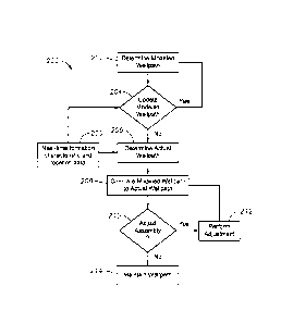
Referring to FIG. 2, operation of the present invention will now be described
according to an exemplary methodology 200. At step 202, once SGG assembly 10
is
deployed downhole, CPU guidance system, via the earth modeling module,
retrieves the
modeled formation and well path from system memory, and analyzes it to
determine and
initiate the modeled well path. At step 204, CPU guidance system 12 determines
whether
it is necessary to update the modeled well path. In order to do so, CPU
guidance system
12 continually monitors the incoming formation characteristic and location
data 205
received from the various system components in real-time as previously
described, and
compares real-time data 205 to the data corresponding to the modeled well
path. As such,
io CPU guidance system 12 then determines if the reservoir model (e.g.,
formation
characteristics and target location) should be updated. If updating is
necessary, the
algorithm utilized by CPU guidance system 12 loops back to step 202 and
remodels the
7
CA 3006150 2018-05-24
well path accordingly. However, if CPU guidance system 12 determines that no
updating
is necessary, the algorithm advances to step 206.
At step 206, CPU guidance system 12 then determines the actual well path of
SGG
assembly 10 utilizing real-time data 205. At step 208, CPU guidance system 12
compares
the actual well path to the modeled well path. Thereafter, at step 210, CPU
guidance
system 12 determines whether SGG assembly 10 requires adjustment. If the
determination
is "yes," CPU guidance system 12 sends a corresponding signal to directional
controller 22
to adjust SGG assembly 10, thereby self-correcting itself at step 212.
Thereafter, the
algorithm loops back to step 206 where, again, CPU guidance system 12
determines the
ro actual well path of SGG assembly 10 and the analysis continually
iterates. However, if at
step 210, CPU guidance system 12 determines that no adjustment is necessary,
the current
well path of SGG assembly 10 is maintained (step 214) until real-time data 205
or some
other signal/data is received (from the surface, for example) that requires
assembly
adjustment. Thereafter, CPU guidance system 12 continually monitors real-time
data 205
to determine whether the modeled well path requires updating (step 204) as
necessary.
Although the exemplary embodiments are described herein in relation to a
drilling
assembly, the self-guided geosteering assembly may also be utilized in a
variety of other
applications. For example, the present invention may be utilized in coiled
tubing or
workover strings to geostecr the workstring into the correct lateral during
workovers in
complex multi-lateral wellbores. The present invention may also be utilized to
identify
and open or close down hole valves, chokes or other production systems when
deployed on
slickline, wireline, coiled tubing or a work string. In these exemplary
applications, the
CPU guidance system would be programmed with a detailed wellbore schematic and
instructions (for example, earth models, work-flow related algorithms, etc.)
of the required
activities. Accordingly, these and other applications will be apparent to
those ordinarily
skilled in the art having the benefit of this disclosure.
An exemplary embodiment of the present invention provides a downhole assembly
comprising processing circuitry to geosteer the downhole assembly, the
processing
circuitry performing a method comprising determining a modeled well path of
the
downhole assembly through a formation, determining an actual well path of the
downhole
assembly through the formation, comparing the modeled well path to the actual
well path
of the downhole assembly and adjusting the actual well path of the downhole
assembly as
necessary to correspond to the modeled well path of the downhole assembly. In
another
8
CA 3006150 2018-05-24
embodiment, determining the modeled well path further comprises analyzing
formation
characteristic data corresponding to the formation surrounding the downhole
assembly,
analyzing location data corresponding to at least one of a location of the
formation
surrounding the downhole assembly or a location of the downhole assembly and
updating
the modeled well path of the downhole assembly based upon the formation
characteristic
data and the location data.
In yet another exemplary embodiment, determining the actual well path further
comprises analyzing formation characteristic data corresponding to the
formation
surrounding the downhole assembly and analyzing location data corresponding to
at least
lo one of a
location of the formation surrounding the downhole assembly or a location of
the
downhole assembly, wherein the actual well path is determined based upon the
formation
characteristic data and the location data. In yet another, adjusting the
actual well path of
the downhole assembly is performed in real-time. In another, adjusting the
actual well
path of the downhole assembly is performed without surface intervention. In
another,
determining the modeled well path of the downhole assembly further comprises
creating
the well path in a geo cellular earth model. In yet another, adjusting the
actual well path of
the downhole assembly further comprises adjusting the actual well path of the
downhole
assembly along a horizontal well. In yet another, the downhole assembly is a
drilling
assembly.
An exemplary methodology of the present invention provides a geosteering
method
for a self-guided downhole assembly positioned within a formation, the method
comprising determining a modeled well path of the downhole assembly through
the
formation, determining an actual well path of the downhole assembly through
the
formation, comparing the modeled well path to the actual well path of the
downhole
assembly and adjusting the actual well path of the downhole assembly as
necessary to
correspond to the modeled well path of the downhole assembly. In another,
determining
the modeled well path further comprises analyzing formation characteristic
data
corresponding to the formation surrounding the downhole assembly, analyzing
location
data corresponding to at least one of a location of the formation surrounding
the downhole
assembly or a location of the downhole assembly and updating the modeled well
path of
the downhole assembly based upon the formation characteristic data and the
location data.
In yet another, determining the actual well path further comprises analyzing
formation characteristic data corresponding to the formation surrounding the
downhole
9
CA 3006150 2018-05-24
assembly and analyzing location data corresponding to at least one of a
location of the
formation surrounding the downhole assembly or a location of the downhole
assembly,
wherein the actual well path is determined based upon the formation
characteristic data
and the location data. In yet another, adjusting the actual well path of the
downhole
assembly is performed in real-time. In another, adjusting the actual well path
of the
downhole assembly is performed without surface intervention. In yet another,
determining
the modeled well path of the downhole assembly further comprises creating the
well path
in a geo cellular earth model. In another, adjusting the actual well path of
the downhole
assembly further comprises adjusting the actual well path of the downhole
assembly along
a horizontal well. Yet another further comprises drilling a wellbore utilizing
the self-
guided downhole assembly.
An exemplary embodiment of the present invention provides a self-guided
geosteering assembly comprising a computer guidance system, a stratigraphic
sensing tool
electrically coupled to the computer guidance system to determine a
characteristic of a
formation surrounding the geosteering assembly, an earth location tool
electrically coupled
to the computer guidance system to determine a location of the geosteering
assembly and a
directional controller electrically coupled to the computer guidance system to
steer the
geosteering assembly in response to signals received from the computer
guidance system.
Another exemplary embodiment further comprises a drill bit. In another, the
computer
guidance system comprises an earth model of the formation. In yet another, the
earth
model further comprises a horizontal well path of the geosteering assembly.
Another
further comprises an imaging tool to determine one or more fracture
characteristics of the
formation surrounding the geosteering assembly.
In yet another, the computer guidance system comprises a processor and a
memory
operably connected to the processor, the memory comprising software
instructions stored
thereon that, when executed by the processor, causes the processor to perform
a method
comprising determining a modeled well path of the downhole assembly through
the
formation, determining an actual well path of the downhole assembly through
the
formation, comparing the modeled well path to the actual well path of the
downhole
lo assembly and adjusting the actual well path of the downhole assembly as
necessary to
correspond to the modeled well path of the downhole assembly.
Although various embodiments and methodologies have been shown and
described, the invention is not limited to such embodiments and methodologies
and will be
CA 3006150 2018-05-24
understood to include all modifications and variations as would be apparent to
one skilled
in the art. Therefore, it should be understood that the invention is not
intended to be
limited to the particular forms disclosed.
Rather, the intention is to cover all
modifications, equivalents and alternatives falling within the spirit and
scope of the
invention as defined by the appended claims.
11
CA 3006150 2018-05-24