Note: Descriptions are shown in the official language in which they were submitted.
CA 03016811 2018-09-06
WO 2017/152227 PCT/AU2017/050203
1
LASER LEVEL CHECKING
FIELD
This invention relates to laser level checking.
BACKGROUND
Laser level checking is a technique used on buildings sites and elsewhere to
check the
level of selected target sites.
The technique typically entails the use of a laser transmitter to define a
reference plane.
Commonly available transmitters produce a horizontal beam that rotates about a
vertical
axis to define the plane although it is also plausible that a transmitter may
produce a
static planar laser. The laser need not project in all directions from the
transmitter
although that is preferred.
When building a typical domestic dwelling, the transmitter will be placed in
sight of a
temporary bench mark (TBM). The TBM is a point selected by a surveying team
and
other levels about the building site are measured in terms relative to the
TBM.
The method typically entails a laser receiving arrangement in the form of a
staff and a
photo detector carried by the staff. The staff is typically in the vicinity of
2 meters high
and is not dissimilar to an oversized ruler in that it has indications of
distance from one
of its ends marked along its length. That one of the ends is a datum.
The photo detector is mounted to slide vertically along the staff and
constitutes a
.. sensing arrangement to sense the reference plane and produce an output
indicative of
alignment of the photo detector with a reference plane. Many existing photo
detectors
include a sensing arrangement in the vicinity of 50 mm high and are configured
to, so
long as they intersect the reference plane, provide an indication of whether
the photo
CA 03016811 2018-09-06
WO 2017/152227 PCT/AU2017/050203
2
detector must be moved up or down until the detector is aligned (within a
tolerance) with
a reference plane.
To check the levels about the building site, the laser receiving arrangement
is first
calibrated by placing its datum on the temporary bench mark and then aligning
the photo
.. detector with the reference plane. The vertical position of the photo
detector along the
staff is then marked off on the staff, typically with a pencil mark.
The laser receiving arrangement is then moved to a target site the level of
which is to be
checked. The datum of the staff is placed on the target site and the photo
detector again
moved vertically along the staff until it is aligned with the reference plane.
The vertical
location of the photo detector relative to the pencil mark provides an
indication of the
elevation of the target site relative to the TBM. A builder would then
typically review the
building plan marked with the desired elevation of the target site and compare
that
number to the number just determined to determine whether the target site must
be built
up (Tilled') or dug out (tut') to achieve the desired level at the target
site.
The process is tedious and complicated and includes ample opportunity for
human error.
A search of patent literature reveals that attempts have been made to address
some of
these problems.
JP 07306046, US 4,693,498 and US 3,894,230 disclose long sensors having photo-
sensitive portions fixed at mutually different distances from a datum to
electronically
sense the height of the reference plane above the target point.
JP 07306046 also discloses horizontally spaced photo-sensitive portions co-
operable
with a rotational beam laser transmitter so that a time difference between the
activation
of the photo-sensitive portions is indicative of the horizontal distance
(crange') between
the transmitter and the sensing arrangement.
CA 03016811 2018-09-06
WO 2017/152227 PCT/AU2017/050203
3
US 2008/0015811 discloses a handheld device that, once suitably aligned with
the
reference plane, uses a laser distance measurement device to determine the
height of
the reference plane above the target point.
US 5,457,890 discloses an electro-mechanical arrangement for automatically
driving the
photo detector up and down a staff. US 4,029,451 discloses a similar electro-
mechanical
arrangement and determining the range by measuring the width of the laser
beam.
Despite these various attempts to improve upon the typical laser receiving
arrangement
it nonetheless remains typical and the inventor has recognised that
significant
improvements over the typical laser receiving arrangement and the devices and
methods of the mentioned patent literature are possible.
It is not admitted that any of the information in this patent specification is
common
general knowledge, or that the person skilled in the art could be reasonably
expected to
ascertain or understand it, regard it as relevant or combine it in any way
before the
priority date.
SUMMARY
One aspect of the invention provides a laser receiving arrangement, co-
operable with a
reference plane defined by a laser transmitter, including
a data storage device on which a respective desired elevation for each of a
plurality of
target points is storable;
a sensing arrangement configured to sense the reference plane and produce an
output
indicative of an elevation of a selected one of the target points relative to
the reference
plane;
a logic arrangement configured to
CA 03016811 2018-09-06
P1330PCAU
PCT/AU2017/050203
Received 12/09/2017
4
receive from the data storage device the respective desired elevation of the
selected one of the target points,
receive the output of the sensing arrangement, and
produce an output based on at least the received elevation and the received
output; and
a user interface configured to produce an output interpretable by a user,
based on the
output of the logic arrangement and indicative of a deviation of the selected
one of the
target points from its respective desired elevation.
Preferably the output of the user interface is indicative of whether the
selected one of
the target points is above or below its desired elevation. The output of the
user interface
may be indicative of a vertical distance from the selected one of the target
points to its
desired elevation.
Another aspect of the invention provides a laser receiving arrangement, co-
operable
with a reference plane defined by a laser transmitter, including
a sensing arrangement configured to sense the reference plane and produce an
output
indicative of an elevation of a target point relative to the reference plane;
a data storage device for storing an elevation of a reference point relative
to the
reference plane;
a logic arrangement configured to
receive from the data storage device the elevation of a reference point
relative to
the reference plane,
receive from the sensing arrangement the elevation of the target point
relative to
the reference plane, and
AMENDED SHEET
IPEA/AU
CA 03016811 2018-09-06
WO 2017/152227 PCT/AU2017/050203
produce an output based on at least the received elevations; and
a user interface configured to, based on the output of the logic arrangement,
produce an
indication, of a vertical deviation of the target point from reference point,
interpretable by
a user.
5 The output of the user interface may be indicative of whether the
selected one of the
target points is above or below the reference point. Preferably the output of
the user
interface is indicative of a vertical distance from the selected one of the
target points to
its desired elevation.
The laser receiving arrangement may include a mobile telecommunications device
defining the user interface. The laser receiving arrangement may include a
mobile
telecommunications device defining the data storage device, the logic
arrangement and
the user interface. Preferably the mobile telecommunications device wirelessly
co-
operates with the sensing arrangement.
The sensing arrangement preferably includes
a staff including a datum for abutting the target point;
one or more photo-sensitive portions movable up and down the staff; and
a position sensing arrangement for, based on a position of the photo-sensitive
portion(s), producing the output indicative of an elevation of a selected
point relative to
the reference plane.
Another aspect of the invention provides a laser system including the laser
receiving
arrangement and the laser transmitter.
Another aspect of the invention provides a computer program configured to
cause a
mobile telecommunications device to co-operate with a sensing arrangement to
form a
CA 03016811 2018-09-06
WO 2017/152227 PCT/AU2017/050203
6
laser receiving arrangement co-operable with a reference plane defined by a
laser
transmitter;
the sensing arrangement being configured to sense the reference plane and
produce an
output indicative of an elevation of a selected one of a plurality of target
points relative to
the reference plane;
the computer program being configured to cause the mobile telecommunications
device
to define
a data storage device on which a respective desired elevation for each of the
plurality of target points is storable;
a logic arrangement configured to
receive from the data storage device the respective desired elevation of the
selected one of the target points,
receive the output of the sensing arrangement, and
produce an output based on at least the received elevation and the received
output; and
a user interface configured to produce an output interpretable by a user,
based on
the output of the logic arrangement and indicative of a deviation of the
selected
one of the target points from its respective desired elevation.
Another aspect of the invention provides a computer program configured to
cause a
mobile telecommunications device to co-operate with a sensing arrangement to
form a
laser receiving arrangement co-operable with a reference plane defined by a
laser
transmitter;
CA 03016811 2018-09-06
P1330PCAU
PCT/AU2017/050203
Received 12/09/2017
7
the sensing arrangement being configured to sense the reference plane and
produce an
output indicative of an elevation of a target point relative to the reference
plane;
the computer program being configured to cause the mobile telecommunications
device
to define
a data storage device for storing an elevation of a reference point relative
to the
reference plane;
a logic arrangement configured to
receive from the data storage device the elevation of a reference point
relative to the reference plane,
receive from the sensing arrangement the elevation of the target point
relative
to the reference plane, and
produce an output based on at least the received elevations; and
a user interface configured to, based on the output of the logic arrangement,
produce an indication, of a vertical deviation of the target point from
reference
point, interpretable by a user.
Another aspect of the invention provides a computer readable medium carrying
the
program.
Another aspect of the invention provides a mobile telecommunications device
configured
to co-operate with a sensing arrangement to form a laser receiving arrangement
co-
operable with a reference plane defined by a laser transmitter;
the sensing arrangement being configured to sense the reference plane and
produce an
output indicative of an elevation of a selected one of a plurality of target
points relative to
the reference plane;
AMENDED SHEET
IPEA/AU
CA 03016811 2018-09-06
P1330PCAU
PCT/AU2017/050203
Received 12/09/2017
8
the mobile telecommunications device being configured to define
a data storage device on which a respective desired elevation for each of the
plurality of target points is storable;
a logic arrangement configured to
receive from the data storage device the respective desired elevation of the
selected one of the target points,
receive the output of the sensing arrangement, and
produce an output based on at least the received elevation and the received
output; and
a user interface configured to produce an output interpretable by a user and
based
on the output of the logic arrangement.
Another aspect of the invention provides a mobile telecommunications device
configured
to co-operate with a sensing arrangement to form a laser receiving arrangement
co-
operable with a reference plane defined by a laser transmitter;
the sensing arrangement configured to sense the reference plane and produce an
output indicative of an elevation of a target point relative to the reference
plane;
the mobile telecommunications device being configured to define
a data storage device for storing an elevation of a reference point relative
to the
reference plane;
a logic arrangement configured to
AMENDED SHEET
IPEA/AU
CA 03016811 2018-09-06
WO 2017/152227 PCT/AU2017/050203
9
receive from the data storage device the elevation of a reference point
relative to the reference plane,
receive from the sensing arrangement the elevation of the target point
relative
to the reference plane, and
produce an output based on at least the received elevations; and
a user interface configured to, based on the output of the logic arrangement,
produce an indication, of a vertical deviation of the target point from
reference
point, interpretable by a user.
Another aspect of the invention provides a method, of checking the elevation
of a target
point, including
utilising a laser receiving arrangement including a laser sensing arrangement;
positioning the sensing arrangement to sense the reference plane and produce
an
output indicative of an elevation of a reference point relative to the
reference plane;
causing the laser receiving arrangement to store the elevation of the
reference point
relative to the reference plane;
positioning the sensing arrangement to sense the reference plane and produce
an
output indicative of an elevation of the target point to the reference plane;
causing the laser receiving arrangement to, based on the elevation of the
reference
point and the elevation of the target point, produce an output indicative of a
vertical
deviation of the target point from the reference point and interpretable by a
user.
Another aspect of the invention provides a staff, co-operable with a reference
plane
defined by a laser transmitter, including
CA 03016811 2018-09-06
WO 2017/152227 PCT/AU2017/050203
a sensing arrangement for sensing the reference plane;
one or more mounting point(s) to which an extension is releasably fittable to
define a
datum for abutting a target point;
an extension sensing arrangement for sensing at least the presence of an
extension
5 fitted to the mounting point(s);
a logic arrangement configured to, based on output from the sensing
arrangement and
on output from the extension sensing arrangement, produce an output indicative
of an
elevation of the reference plane above the target point.
The extension sensing arrangement is preferably configured to sense a length
of an
10 extension fitted to the mounting point(s). Most preferably the extension
sensing
arrangement is configured to sense a length of a series, of extensions, fitted
to the
mounting point(s).
The sensing arrangement preferably includes
one or more photo-sensitive portions movable up and down the staff; and
a position sensing arrangement for, based on a position of the photo-sensitive
portion(s), producing the output from the sensing arrangement.
The extension sensing arrangement may include electrical contacts associated
with the
mounting point(s) to electrically connect the extension sensing arrangement to
an
extension fitted to the mounting point(s).
Another aspect of the invention provides a laser receiving arrangement
including
the staff; and
CA 03016811 2018-09-06
WO 2017/152227 PCT/AU2017/050203
11
a first extension for mechanically and electrically connecting the staff to a
second
extension that is identical to the first extension;
the first extension being co-operable with the mounting point(s) and contacts
of the staff
and defining further mounting point(s) and contacts co-operable a second
extension.
Another aspect of the invention provides a laser receiving arrangement
including the
staff and an extension co-operable with the staff and configured to provide at
least an
indication of length to the extension sensing arrangement.
Another aspect of the invention provides an extension for a staff;
the staff being co-operable with a reference plane defined by a laser
transmitter;
the extension being co-operable with another extension that is identical to
the extension;
the extension including
an elongate body;
top mounting point(s), and top electrical contacts, co-operable with mounting
point(s), and electrical contacts, of the staff; and
bottom mounting points, and bottom electrical contacts, co-operable with top
mounting point(s), and top electrical contacts, of the other extension to
mechanically and electrically connect the other extension to the staff.
The extension may include electrical means associated with the top electrical
contacts
for conveying to the staff information at least relatable to a length of the
extension.
Also disclosed is a laser receiving arrangement, co-operable with a reference
plane
defined by a laser transmitter, including
CA 03016811 2018-09-06
WO 2017/152227 PCT/AU2017/050203
12
a data storage device in which a desired profile is storable;
a sensing arrangement configured to sense the reference plane and produce an
output
indicative of an elevation, of selected target point relative to the reference
plane, and a
distance of the selected target point from transmitter;
a logic arrangement configured to
receive information, from the data storage device, and the output from the
sensing
arrangement; and
produce an output based on at least the received information and the received
output; and
a user interface configured to produce an output interpretable by a user,
based on the
output of the logic arrangement and indicative of a deviation of the selected
target point
from the desired profile.
Also disclosed is a computer program configured to cause a mobile
telecommunications
device to co-operate with a sensing arrangement to form a laser receiving
arrangement
co-operable with a reference plane defined by a laser transmitter;
a sensing arrangement configured to sense the reference plane and produce an
output
indicative of an elevation, of a selected target point relative to the
reference plane, and a
distance of the selected target point from transmitter;
the computer program being configured to cause the mobile telecommunications
device
to define
a data storage device in which a desired profile is storable;
a logic arrangement configured to
CA 03016811 2018-09-06
WO 2017/152227 PCT/AU2017/050203
13
receive information, from the data storage device, and the output from the
sensing arrangement; and
produce an output based on at least the received information and the
received output; and
a user interface configured to produce an output interpretable by a user,
based on
the output of the logic arrangement and indicative of a deviation of the
selected
target point from the desired profile.
Also disclosed is a computer readable medium carrying one of the computer
programs.
Also disclosed is a mobile telecommunications device configured to co-operate
with a
sensing arrangement to form a laser receiving arrangement co-operable with a
reference plane defined by a laser transmitter;
the sensing arrangement being configured to sense the reference plane and
produce an
output indicative of an elevation, of selected target point relative to the
reference plane,
and a distance of the selected target point from transmitter;
the mobile telecommunications being configured to define
a data storage device in which a desired profile is storable;
a logic arrangement configured to
receive information, from the data storage device, and the output from the
sensing arrangement; and
produce an output based on at least the received information and the
received output; and
CA 03016811 2018-09-06
WO 2017/152227 PCT/AU2017/050203
14
a user interface configured to produce an output interpretable by a user,
based on
the output of the logic arrangement and indicative of a deviation of the
selected
target point from the desired profile.
BRIEF DESCRIPTION OF DRAWINGS
Embodiments of the disclosed apparatus and methods will now be described by
way of
example only with reference to the accompanying drawings in which:
Figure 1 schematically illustrates a laser receiving arrangement;
Figure 2 is a vertical cross-section view along the centre line of a drainage
trench;
Figure 3 schematically illustrates a staff;
Figure 4 schematically illustrates a laser level-checking system;
Figures 5 to 24 are screen shots of a preferred user interface; and
Figures 25 and 26 schematically illustrate the use of a laser level-checking
system to
check/set the levels for a first floor.
DESCRIPTION OF EMBODIMENTS
The following examples are intended to illustrate to enable reproduction and
comparison. They are not intended to limit the scope of the disclosure in any
way.
The laser receiving arrangement 1 includes a staff 2 and a mobile
telecommunications
device (MTD) 3.
The staff 2 is about 2 metres high and includes a sensing arrangement 5
running
vertically along its length. The bottom end of the staff is a datum 7. In use
the datum 7 is
placed on a selected target site on the ground the level of which is to be
checked. The
CA 03016811 2018-09-06
WO 2017/152227 PCT/AU2017/050203
staff is then held upright. For this purpose the staff may include a mechanism
for
checking verticality of the staff such as a bubble trapped within a suitable
transparent
housing.
The sensing arrangement 5 is made up of photosensitive portions at respective
5 .. distances from the datum 7. These portions are responsive to a laser
defining a laser
reference plane. Thus the distance of the responsive one of the portions from
the datum
7 corresponds to the height of the reference plane above the target point.
The staff 2 incorporates a transmitter 9 for wirelessly transmitting the
elevation, of the
reference plane above the target point, to the MTD 3.
10 .. The MTD 3 is configured by a computer program, known as an app,
downloaded from
an on-line environment. The computer program configures the MTD 3 to store a
desired
elevation for each of a plurality of target sites along with a respective
identifier for each
of the target sites. The identifier could be descriptive text such 'garage 1'
and 'garage 2'
or something more elaborate. Optionally the identifier could be a set of
navigational co-
15 .. ordinates whereby the computer program can configure the mobile phone to
enable a
target site to be selected by moving the mobile phone into proximity with the
target site.
Preferably, the identifier is simply a number corresponding to a number marked
for the
target site on a building plan.
The mobile phone can be preloaded with the desired elevation for each target
site in the
.. comfort of an office environment before arriving on the building site. This
alone reduces
the prospects of human error.
Upon arrival at the building site the user positions the laser transmitter
within sight of the
TBM and the target sites in conventional fashion. The datum 7 is then placed
on the
TBM. Often the TBM will be clearly marked such as by a dot of spray paint on
the
footpath at the front of the building site. With the staff held upright, a
reference elevation
can be captured. For this purpose, the MTD 3 is preferably configured by the
computer
program to present an intuitive call for action via its user interface.
Preferably the MTD's
CA 03016811 2018-09-06
WO 2017/152227 PCT/AU2017/050203
16
touch screen presents an icon clearly labelled 'capture reference' or similar.
In an
alternate variant of the arrangement 1, the staff 2 incorporates its own
calibration facility
by which the reference value can be captured so that the subsequent output
from the
staff is adjusted by this value.
Once the operator has operated the MTD to capture the reference elevation they
can
move on to a first of the target sites. The datum 7 is placed on the first
target site and
the staff is held upright. The operator selects, via the touch screen of the
MTD 3, the first
target site, e.g. by pressing a icon clearly marked 'target site 1' or
similar.
The MTD, as configured by the downloaded program, then compares at least the
elevation received from the staff 2 and the desired elevation to assess the
deviation
between the target site's elevation and its desired elevation. Typically the
reference
elevation will also be factored into the comparison, although it is plausible
that the
transmitter could be set at the same height as the TBM, or that the desired
elevations
include an allowance for a predetermined reference elevation to which the
transmitter is
set.
Preferably the desired elevations are stored as elevations relative to the
height of the
TBM, in which case the output from the staff 2 is preferably modified by the
subtraction
of the reference elevation before it is compared to the desired elevation. By
way of
example, the modified output from the staff 2 may indicate that the target
site is
measured at 100 mm above the TBM and the desired elevation for that site may
be
300 mm above the TBM in which case a comparison, of the output of staff 2 in
its
modified form to the desired elevation, in the form of subtraction indicates
that the target
site must be built up by 200 mm.
Alternatively the output from the staff 2 may be directly compared to a
modified form of
the desired elevation, the modified form of the desired election being the
addition of the
reference elevation and the desired elevation of the target site relative to
the TBM.
CA 03016811 2018-09-06
WO 2017/152227 PCT/AU2017/050203
17
The MTD 3, as configured by the program, preferably displays the necessary
action to
achieve the desired elevation. In the example of Figure 1 the MTD 3 conveys
via its
screen an up arrow and the word cfill conveying the direction of the necessary
surface
modifications. Both the arrow and the word fill are indicative of the target
point being
below its desired elevation. The screen further conveys a simple numeric
output
indicating that the ground must be built up by 200 mm. The operation of the
laser
receiving arrangement 1 on site is thus simple and intuitive, and minimises
the
opportunity for human error. The MTD may be configured to store the deviation
from the
desired elevation for later reference.
.. It is frequently desirable to build inclined features. A drainage trench is
a simple example
of such a feature. Figure 2 illustrates a drainage trench partially
constructed with the aid
of the laser receiving arrangement 1 in which the MTD 3, as configured by the
program,
is operating in another operating mode. In this other operating mode rather
than storing
elevations for pre-selected target points, the MTD 3 stores a desired profile
for the
inclined feature.
The transmitter T is positioned along the centre line of the planned trench.
The staff 2 is
then placed on the TBM and a referenced range and elevation captured,
preferably
using appropriate capture icons on the touch screen. In this example the staff
2 is
configured to also provide an output indicative of the range R of the staff 2
from the
transmitter T. By way of example this range of measurement may be based on the
width
of the laser beam or the time that it takes for a laser beam to pass between
horizontally
spaced sensing portions of the staff 2.
Through a comparison process similar to that previously described, the MTD
compares
the output from the staff 2 to the desired profile to indicate whether the
site at which the
staff is placed is above or below the desired profile and how far from the
desired profile
the selected point is. In this way the staff can be dropped into the drainage
trench whilst
an excavator is momentarily paused to very rapidly provide an indication as to
whether
the excavation is on course. A site is selected as a target site by simply
placing the
CA 03016811 2018-09-06
WO 2017/152227 PCT/AU2017/050203
18
datum 7 upon it. A simple intuitive output is provided without any need for
specific user
input whilst the excavator is paused.
In the described examples the MTD 3 is configured to define a data storage
device, a
logic arrangement and a user interface although of course other examples of
the
invention are possible. Using a MTD in this way is preferred in that most
users will have
an MTD with them and by utilising its processing power and other resources the
costs of
duplicating those resources in the staff arrangement 2 can be avoided,
although other
variants of the invention may well have such features built into the staff. It
is also
possible that various components of the receiving arrangement may be
distributed. By
way of example the MTD 3 may communicate via the internet with an off-site
data
storage device and logic arrangement.
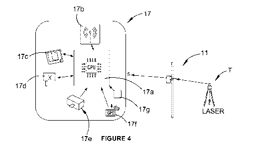
Figure 3 illustrates an alternate laser receiving staff 11 including a staff
body 13 and a
scale 15 carried by the body 13. The staff further includes a module 17
movable up and
down the body 13. At the base of the body 13 is a connection arrangement 17
including
mounting points and electrical connections by which the staff 11 is
mechanically and
electrically connectable to an extension piece.
The module 17 co-operates with a logic arrangement 17a (that includes a CPU),
an
antenna 17b for forming a wireless link with outside devices, a screen 17c for
displaying
information to users, a position sensing arrangement 17d, a magnetometer 17e
for staff
compensation and a GPS antenna 17f, and a laser detector 17g for sensing the
reference plane. Ideally the staff should be held exactly vertically upright
when in use
although the staff includes the magnetometer 17e to enable it to compensate
for any
angle away from the vertical to provide a more accurate reading to the end
user. A tilt
sensor such as an accelerometer may be employed to similar effect.
The position sensing arrangement 17d may take the form of a capacitive reader
head
co-operative with the scale 15 to sense the position of the module 17. An
encoder is
another option.
CA 03016811 2018-09-06
WO 2017/152227 PCT/AU2017/050203
19
Proprietary scale and capacitive reader head combinations are available and
are
preferred for cost efficiencies. Preferably the remainder of the module 17
depends from
the reader head 17d.
In use, the module 17 is manually moved up and down the staff until
satisfactorily
aligned with the reference plane. To assist with this alignment, the logic
arrangement
17a, responsive to the detector 17g, may produce an output (e.g. an audible or
visual
output) to inform the operator of satisfactory alignment. When the module 17
is so
aligned, the output from the position sensing arrangement 17d is indicative of
the
elevation of the reference plane above the point on which the base 19 is
seated.A drive
arrangement by which the module 17 is driven vertically along the staff to
automatically
locate the reference plane is also contemplated.
The module 17 preferably further includes a general purpose 10 to accommodate
calibration inputs, at height indication, Wi-Fi connection, etc.
According to a preferred form of the invention, up to three 1000 mm staff
extensions can
be added to the lower section 19 of the main staff. This is to allow for sites
that have a
fall of more than the maximum length of the linear scale.
The main electronics 17a will automatically detect how many extensions are
present and
auto compensate on the final readings, this will eliminate any possible
operator error
and ensure data integrity.
The auto detection is achieved by deploying a loop back system into the staff.
There will
be 2 contacts that loop a signal back to the main CPU, when an extension is
fitted this
loop back will be moved to the lower section of the extension and a unique
code is sent
to the main CPU so it can adjust accordingly. The same applies for the other 2
extensions each one or any combination of extensions or no extensions will
produce a
unique code.
CA 03016811 2018-09-06
WO 2017/152227 PCT/AU2017/050203
There are other mechanisms by which the addition of one or more extension
pieces may
be automatically recognised. By way of example, each extension piece might be
tagged
with a simple 2-bit passive RFID tag for providing a back-scattered signal (in
response to
a suitable excitement provided by the staff 11) by which the logic arrangement
17a can
5 recognise the extension as being one of four predetermined lengths.
Figures 5 to 24 are screenshots from a mobile telecommunications device MTD
configured with a suitable app to co-operate with the module 17 via the
antenna 17b,
e.g. via Bluetooth connection.
P1 HOME PAGE
10 This page contains a display screen that provides readings of the
horizontal beam. It
also contains up to 11 other various options that assist the user to program,
set heights
and levels for up to 20 sites/locations.
Selection S2
Saved jobs will be displayed on page 2: Preprogrammed jobs. These can be
15 .. programmed off site using the plans and the TBM reading that is given
from the
surveyor.
Selection S6
This will allow the user to program the level/ FFL (Finished Floor Level) from
the TBM.
Selection S18
20 This function allows the user to obtain a GPS reading and for it to be
saved to a specific
site/location. This function can also be used as a GPS in general terms for
the user to
navigate between sites/locations that are already saved in the staff.
CA 03016811 2018-09-06
WO 2017/152227 PCT/AU2017/050203
21
P2 PREPROGRAMMED JOBS
This page has the capability to save up to 20 preprogrammed jobs by the touch
of the
screen. Simply select the job that is required. For example Browns Rd.
Selection S3
Once the user selects the required site/location, for example Browns Rd, the
preprogrammed heights will appear.
Selection 53A
The laser transmitter (aka laser level) may be moved about the work site as
required
(e.g. to have a light of sight to each of the TBM and a target site as
required). As such, it
is important that the laser-receiving arrangement is periodically
recalibrated. This is
achieved by placing the staff at the temporary benchmark and making the
touchscreen
selection 53A. In this way, the height of the reference plane relative to the
temporary
benchmark is captured and stored on the mobile telecommunications device.
P3 PREPROGRAMMED MEASUREMENTS ASSOCIATED WITH THE SELECTED
SITE/LOCATION
All the measurements associated with, for example, Browns Rd, are listed on
this page
once they have been entered via S6 on home page.
Selection 538
This function allows the user to review previously taken photos along with
taking new
images of the desired site/location and then gives the user the ability to
store the images
under the site/locations file.
CA 03016811 2018-09-06
WO 2017/152227 PCT/AU2017/050203
22
Selection 53C
This function allows the user to obtain a GPS reading and for it to be saved
to a
specifically to a site/location. This function can also be used as a GPS in
general terms
for the user to navigate between sites/locations that are already saved in the
staff.
Selection S3D
This function allows the user to edit, add or change levels on site but this
is protected by
a PIN (or other suitable lock-out feature) so that levels cannot be altered by
mistake.
Selection 53E
This function allows the user to view plans for the associated site/location.
Selection S4
Allows the user to select height of concrete slab/ground floor. The TBM will
need to
calibrate at the TBM marked by the surveyor before use.
P4 RECALIBRATION PAGE
Once the user has selected the required target site from P3, they will then be
prompted
to recalibrate the staff/level from the TBM every time as the horizontal beam
will not be
in the same place/height every time. Once the user has set the laser level up,
they will
then need to place the staff over the TBM and press the reset button to take
the reading.
Once this had been done, the selected height will appear and the staff is
ready to use. If
at any time the laser level is moved, the user will have to recalibrate the
staff.
CA 03016811 2018-09-06
WO 2017/152227 PCT/AU2017/050203
23
Selection 54A
The staff is recalibrated by selecting this option, which will find the
horizontal laser beam
automatically. Once the laser is centred to the beam it will alert the user
that it has
completed calibration by beeping. Select save and the selected level will
appear for use.
P4A SAVED SLAB LEVEL PAGE
This page will display the selected level, in this case the slab. The
preprogrammed
height reading will also appear in the middle of the display screen along with
an
indication of the amount and direction of the deviation from the preprogrammed
height.
In this case the amount and direction are respectively 0.02 mm and up.
Selection S5
This function allows the user to edit, add or change levels on site but this
is protected by
a PIN so that levels cannot be altered by mistake.
P5 EDIT PRESELECTED MEASUREMENTS PAGE
This page is where the selected levels can be edited, added to or changed. For
example, if you need to add a polished topping slab, by using the keyboard
type in
TOPPING SLAB and select save.
Selection S9
This function allows the user to save the new level. When the slab level is
adjusted the
measurements will appear in the calculator on P9. Once save is selected, the
previous
slab level will appear in the calculator ready for the new height to be added.
Select save
to make sure details are obtained. Once measurements are saved, the new level
will
appear on P3 ready for use.
CA 03016811 2018-09-06
WO 2017/152227 PCT/AU2017/050203
24
P6 ONSITE PROGRAMMING: CREATING NEW JOB
To start you must enter the TMB into the staff and save it before calibrating
the staff
from the TBM at the front of the job or the measurements provided by the
surveyor.
These details can also be manually entered using the calculator.
Selection S7
This function allows the user to save the TBM to a new job page by using the
keyboard
type the desired name of the site/location.
Selection 57A
This function allows the user to enter new levels associated with a
site/location whilst
onsite. Before this can be done, the staff may need to be calibrated to the
TBM. Once
the user enters the new levels into the staff and selects save, it is then
ready for use.
P7 ONSITE PROGRAMMING: ADDING NEW HEIGHTS
Once the TBM reading is saved a new tab can be selected. Then, using the
keyboard,
title the new height, select save and add the ground floor height from the
plans.
Option 1
By using the surrounding measurements, the calculator can be used to adjust
selected
heights or requirements. Use the TBM to manually select the desired height by
adding or
subtracting from the TBM height set by the surveyor.
Option 2
Enter the finished floor level as per plans and select save.
CA 03016811 2018-09-06
WO 2017/152227 PCT/AU2017/050203
P8 ONSITE PROGRAMMING: ADDING NEW HEIGHTS (CONT'D)
This page allows the user to program split floor levels into the staff.
Selection S11
This function allows the user to directly enter floor measurements off the
plan and into
5 the staff by using the calculator and then the keyboard by giving the
level a name if
needed.
P9 EDIT PREPROGRAMMED MEASUREMENTS
This page shows the user all the previously saved information for a particular
site/location. It also allows the user to add new heights by the 'Add new
tag'.
10 Selection S10
This function allows the user to save the new height associated to a
particular
site/location by using the 'Add new tag'. For example, the user will see the
job Browns
Rd at the top of the page and all of the previously saved measurements below.
If the
user was wanting to add in a topping slab on top of the structural slab, the
user would
15 enter the measurements of the structural slab height and the thickness
of the topping
slab into the calculator, selecting enter and save, then the measurements will
appear
below the previously saved measurements.
P10 PREPROGRAMMED MEASUREMENTS ASSOCIATED WITH THE SELECTED
SITE/LOCATION
20 This page shows the user all the measurements associated with a selected
site/location.
For example, all the measurements for Browns Rd are listed on this page, once
they
have been entered via S6 or S10.
CA 03016811 2018-09-06
WO 2017/152227 PCT/AU2017/050203
26
P11 ONSITE PROGRAMMING: CREATING NEW HEIGHTS
This page shows the user all the previously saved information for a particular
site/location. It also allows the user to add new heights by the 'Add new
tag'. Pages 11
and 12 are bridging steps for sites with split level floors.
Enter
Selecting 'Enter' switches by the keypad from letters (PII) to numbers (PI
IA).
Selection S12
This function allows the user to enter new levels associated with a
site/location whilst
onsite (as per S10).
Selection 512A
This function allows the user to save the new height to the 'Add new tag' (as
per S10).
P12 ONSITE PROGRAMMING: CREATING NEW HEIGHTS (CONT'D)
This page shows the user all the previously saved information for a particular
site/location. It also allows the user to add new heights by the 'Add new
tag'. Pages 11
and 12 are bridging steps for sites with split level floors.
Selection S13
This function allows the user to enter new levels associated with a
site/location whilst
onsite (as per S10).
Selection 513a
This function allows the user to save the new height to the 'Add new tag' (as
per S10).
CA 03016811 2018-09-06
WO 2017/152227 PCT/AU2017/050203
27
P13 ONSITE PROGRAMMING: CREATING NEW HEIGHTS (CONT'D)
This page provides the user with the steps to obtain a level that is above the
horizontal
beam. The user will enter the height off the plans first, in this case the
first floor unit 1, by
selecting 'Add new tag' and following steps as per S10.
Selection S14
This function 'Hill climbing/Measurement link' is selected when the user is
attempting to
get a height that is out of reach of the horizontal beam. The first step is to
press 'Hill
climbing/Measurement link' and then select the name of the height that is out
of reach of
the horizontal beam.
P14 ONSITE PROGRAMMING: CREATING NEW HEIGHTS (CONT'D)
This page will display the selected level, in this case the first floor unit
1. The
preprogrammed height reading will also appear in the middle of the display
screen.
Selection S15
Selecting the 'Edit and 'Reset/Calibrate' tabs will allow the user to take a
reading to find
the height of the horizontal beam. In this case the user will use the slab to
get the height
of the horizontal beam. The staff is calibrated by selecting this option,
which will find the
horizontal laser beam automatically. Once the laser is centred to the beam it
will alert
the user that it has completed calibration by beeping. Select save and the
distance from
the selected height from the slab to the horizontal beam will appear.
P15 ONSITE PROGRAMMING: CREATING NEW HEIGHTS (CONT'D) (AS PER
FIGURE 25)
All the measurements associated with, for example, Main St are listed on this
page. The
user now knows that from the slab unit 1 to the horizontal beam is 1.200 m.
From the
CA 03016811 2018-09-06
WO 2017/152227 PCT/AU2017/050203
28
plan you can calculate that from the slab to the top of the first floor is 3
m. By using basic
math, you subtract 1.200 m from 3 m and you are left with 1.800 m which is the
distance
left to the horizontal beam to the first floor.
Selection S16
.. This function allows the user to save the new height associated to a
particular
site/location by using the 'Add new tag'. The measurements will appear below
the
previously saved measurements. By using the keyboard, type in the name of the
new
height, then select enter on the keyboard and the user will be able to switch
to the
calculator. For example, enter the height of the first floor unit 1 into the
calculator, then
subtract the 1.800 m. Once this is completed, select save and the new height
will appear
below the previously saved measurements.
P16 USING PREPROGRAMMED MESUREMENTS ONLINE
This page contains all the preprogrammed heights associated with a particular
site/location.
Selection S17
Allows the user to select height of the 'First floor unit 1 staff upside
down'. The TBM will
need to be calibrated at the TBM marked by the surveyor before being used
again.
P17 USE OF STAFF ONSITE WHILST USING 'FIRST FLOOR UNIT 1 STAFF UPSIDE
DOWN' (AS PER FIGURE 26)
This page will display the selected level, in this case the 'First floor unit
1 staff upside
down'. The preprogrammed height reading will also appear in the middle of the
display
screen.
CA 03016811 2018-09-06
WO 2017/152227 PCT/AU2017/050203
29
P18 GPS/NAVIGATION
This page will display the GPS location and navigation to the next
site/location.
As per S18 on page 1.
As suggested in Figure 24, the software can assist operators with navigation
between
job sites. The GPS function can also be helpful on site. On the job site, the
selection of
target sites at page 3 (Figure 7) may be guided or even automated with the aid
of GPS.
In a guided variant, the GPS antenna of the mobile telecommunications device
or of the
module 17 may be employed to provide an indication of which of the preset
target sites
is in proximity to the receiving arrangement. By way of example, when the
staff 11 is
moved to within a tolerance of the 'pit 4' target site, the pit 4 button of
the touchscreen
may illuminate, making it available for selection. In this way, the selection
of the
appropriate site is guided, reducing the risk of on site errors.
The present inventors have recognised that GPS signals taken within a limited
timeframe often have a systematic error of a meter or two in one direction or
another. To
account for this systematic error, a calibration process is contemplated. By
way of
example, when the selection S3A is made with the staff 11 at the TBM, the GPS
signal
may be captured to obtain an estimate of the systematic error. That estimate
can then
be used to adjust subsequent GPS readings. Optionally, the system may demand
periodic recalibration, e.g. every half hour or so. Of course, the described
method of
compensating for the systematic error in GPS signals may well be
advantageously
applied to laser level checking arrangements beyond those described herein.
Indeed, it
may well be applied beyond the context of laser level checking.
Various examples have been described. The invention is not limited to these
examples.
Rather, the invention is defined by the claims.