Note: Descriptions are shown in the official language in which they were submitted.
CA 03027670 2018-12-13
WO 2017/221166 PCT/IB2017/053689
1
SAR IMAGING METHOD FOR INTERFEROMETRIC ANALYSES
TECHNICAL FIELD OF INVENTION
The present invention relates, in general, to remote sensing
by means of synthetic aperture radar (SAR) and, in particular,
to SAR-based interferometry.
More specifically, the present invention concerns a technique
for generating SAR images for interferometric analyses. The
present invention finds advantageous, although not exclusive,
application in the processing of raw SAR data related to two
or more SAR acquisitions performed in burst mode.
STATE OF THE ART
As is known, one of the most widespread applications in the
world of SAR systems is interferometry, with its different
solutions that range from estimating a digital elevation model
(DEM) for an area of interest, to estimating the height
variation of targets (differential interferometry) and
detecting changes in two scenes (coherent change detection).
The main mode of SAR acquisition for interferometry is the so-
called Stripmap, because the acquisition characteristics and,
in particular, the azimuth angle parameters are substantially
invariant for targets arranged along the azimuth. Although,
with a little more complexity, other operating modes (in
particular Spotlight, ScanSAR, PingPong and TOPS) can also be
used for interferometric applications.
A typical reference geometry for generating SAR images of the
earth's surface is shown in Figure 1. With regard to this, it
is wished to underline the fact that in Figure 1 (and also in
the following figures that will be presented and described
hereinafter), the earth's surface is (and will be) shown
"flat" only for convenience and simplicity of illustration and
description, without any loss of generality.
CA 03027670 2018-12-13
WO 2017/221166 PCT/IB2017/053689
2
In particular, Figure 1 schematically shows a synthetic
aperture radar 10 (hereinafter called a SAR sensor, for
simplicity of description) that moves along a flight direction
d at an altitude h (with respect to the earth's surface)
assumed to be substantially constant. As is known, the
altitude h of the SAR sensor 10 is measured along a nadir
direction z that passes through said SAR sensor 10 (in
particular it passes through the phase centre of the antenna
of the SAR sensor 10) and is orthogonal to the earth's surface
and the flight direction d. Conveniently, the SAR sensor 10 is
transported in flight/orbit by an aerial/space platform (not
shown in Figure 1 for simplicity of illustration) such as, for
example, a plane, an unmanned aerial vehicle (UAV) or a
satellite. The ground track of the flight direction d
identifies an azimuth direction x that is parallel to said
flight direction d and orthogonal to the nadir direction z,
while a cross-track direction y, which is orthogonal to both
the nadir direction z and the azimuth direction x, together
with the azimuth direction x, identifies an x-y plane
tangential to the earth's surface. In use, by means of an
opportune antenna (not shown in Figure 1 for simplicity of
illustration), the SAR sensor 10 transmits radar pulses and
receives the associated back-scattered signals in an
acquisition direction sr that identifies the slant range and
which forms an elevation angle el to the nadir direction z and
a squint angle cp to the flight direction d (or, equivalently,
to the azimuth direction x) that, in the SAR acquisition
geometry shown in Figure 1, is equal to (approximately) 90
(so-called "almost-zero-Doppler" geometry).
In particular, in the stripmap type of SAR acquisition
geometry shown in Figure 1, the SAR sensor 10 illuminates a
strip of the earth's surface, known as a swath, with radar
pulses and then receives the associated back-scattered signals
from the swath, which mainly extends parallel to the azimuth
CA 03027670 2018-12-13
WO 2017/221166 PCT/IB2017/053689
3
direction x and which has a given width W along the cross-
track direction y. For greater clarity, Figure 2 shows the
geometry of SAR acquisition in stripmap mode in the x-y plane,
where it is possible to observe how the squint angles cp are
all the same; in particular, in the example shown in Figure 2,
the squint angles cp are all right angles ("almost-zero-
Doppler" geometry).
Moreover, Figure 3 schematically shows, from a radiometric
standpoint, how a target (indicated by reference numeral 11)
positioned on the earth's surface is illuminated, in stripmap
mode, by the antenna beam (indicated by reference numeral 12)
of the SAR sensor 10. In particular, as shown in Figure 3
(where reference is made to the x-z plane of the previously
introduced xyz Cartesian reference system, already used in
Figures 1 and 2), the target 11 is illuminated by the entire
antenna beam 12. More generally, each point of the image along
the azimuth direction x is illuminated with the same beam
portions, i.e. it receives the same power; as a consequence,
the so-called "scalloping" effect is not present in stripmap
mode.
In addition, Figure 3 also shows the radiometric correction
(indicated by reference numeral 13) applied/applicable to the
signal related to the target 11 (even if this radiometric
correction is not strictly necessary in stripmap mode because,
as just explained, all the points are illuminated, along the
azimuth direction x, with the same beam portions).
As is known, the azimuth resolution for a SAR acquisition in
stripmap mode is a function of the angular aperture (or
angular difference - delta angle) with which a target is
observed by the SAR sensor; or, in an equivalent manner, the
azimuth resolution can be also seen as a function of the time
difference (delta time), linked to the velocity of the SAR
sensor, with which the target is observed. In particular, the
CA 03027670 2018-12-13
WO 2017/221166 PCT/IB2017/053689
4
azimuth resolution can be expressed by the following equation
(for further details, reference can be made, for example, to
G. Franceschetti and R. Lanari, "Synthetic Aperture RADAR
Processing", CRC Press, March 1999):
0.886A
resStri)
2* delta angle
where ressfrip indicates the stripmap azimuth resolution, A
indicates the wavelength used by the SAR sensor and delta angle
indicates the angular aperture (or angular difference - delta
angle) with which the target is observed by the SAR sensor.
Assuming the angle as a 3 dB aperture (one-way) of the antenna
(=0.886A/L, where L indicates the physical or equivalent
length along the azimuth direction of the antenna of the SAR
sensor), the constraint traditionally associated with the
azimuth resolution for the stripmap mode can be obtained,
which is equal to L/2 (for further details, please refer again
to "Synthetic Aperture RADAR Processing").
Currently, very wide antenna beams are used to improve the
azimuth resolution, these being achieved through the use of
antennas of small size or under-illuminated or with amplitude
and/or phase modulation such as to reduce the equivalent size,
or by using the so-called spotlight mode, the acquisition
logic of which is schematically illustrated in Figure 4.
In particular, as shown in Figure 4 (where reference is made
to the x-y plane of the previously introduced xyz Cartesian
reference system, already used in Figures 1-3), the SAR
acquisition logic in spotlight mode envisages using a
continuous, or quasi-continuous, steering of the antenna beam
during the flight movement of the SAR sensor 10 (by
dynamically adjusting the value of the squint angle (p) so as
to always illuminate a same area of interest with the radar
pulses and then receive the associated back-scattered signals
therefrom, in this way increasing the persistence time of the
CA 03027670 2018-12-13
WO 2017/221166 PCT/IB2017/053689
SAR sensor 10 on said area of interest and thus improving the
azimuth resolution.
Both of the aforementioned methodologies used for improving
5 the azimuth resolution suffer from some drawbacks. In
particular, the use of very wide antenna beams requires using
very high transmission powers, while the spotlight mode
introduces limitations on the azimuth length of the swaths.
One solution to the aforementioned drawbacks is provided by
International Patent Application WO 2014/122624 Al, which
concerns a method for generating SAR images that comprises
performing N SAR acquisitions in stripmap mode of areas of the
earth's surface by means of a synthetic aperture radar that is
transported by an aerial or satellite platform and which
comprises a single, non-partitioned antenna and a single
receiver coupled to said single, non-partitioned antenna,
where N is an integer greater than one.
In particular, according to WO 2014/122624 Al, all N SAR
acquisitions in stripmap mode are performed using a same
predetermined elevation angle with respect to the nadir of the
synthetic aperture radar in such a way that said N SAR
acquisitions in stripmap mode all regard a same specific swath
of the earth's surface. Instead, each SAR acquisition in
stripmap mode is performed using a respective squint angle
with respect to the flight direction of the synthetic aperture
radar, said respective squint angle being different from the
squint angle used to perform the other N-1 SAR acquisitions in
stripmap mode.
Furthermore, according to WO 2014/122624 Al, each
SAR
acquisition performed in stripmap mode comprises respective
radar transmission and reception operations that:
= are time interleaved, individually or in groups, with
single, or groups of, radar transmission and reception
CA 03027670 2018-12-13
WO 2017/221166 PCT/IB2017/053689
6
operations of the other N-1 SAR acquisitions performed in
stripmap mode; and
= comprise the transmission and reception of respective
radar beams in respective acquisition directions that are
defined by the predetermined elevation angle and by the
respective squint angle used for said SAR acquisition in
stripmap mode, thereby resulting in that said respective
acquisition directions are parallel to each other and not
parallel to the acquisition directions of the other N-1 SAR
acquisitions performed in stripmap mode.
Furthermore, according to WO 2014/122624 Al, the radar beams
transmitted and received in two radar transmission and
reception operations performed in two immediately successive
moments in time and related to two different SAR acquisitions
in stripmap mode are contiguous along the azimuth, in this way
increasing the integration times with respect to those
obtainable via any single one of the N SAR acquisitions
performed in stripmap mode.
Finally, the method according to WO 2014/122624 Al also
comprises generating SAR imaging of areas of the specific
swath on the basis of all the N SAR acquisitions performed in
stripmap mode, said SAR images having an azimuth resolution
that is enhanced by a factor of up to N with respect to a
nominal stripmap azimuth resolution, which is equal to half
the physical or equivalent length along the azimuth direction
of the single, non-partitioned antenna of the synthetic
aperture radar.
As is known, in order to exploit the capabilities of a SAR
system to the maximum, in addition to the stripmap and
spotlight modes, various other techniques have been proposed
over the years for using SAR sensors, including the so-called
burst modes.
CA 03027670 2018-12-13
WO 2017/221166 PCT/IB2017/053689
7
In particular, the burst modes are based on the concept of
time division, i.e. the SAR acquisition is divided into
separate time blocks (so-called "bursts") that, opportunely
aggregated, enable observing:
= several subswaths, in this way increasing the observed
surface (ScanSAR mode); or
= a same area using different electromagnetic
characteristics, for example, using different polarizations
(PingPong mode).
The main burst mode is the ScanSAR mode, which divides time
into synchronous bursts (i.e. with a regular rate). A scene
portion at the antenna's nominal pulse repetition frequency
(PRF) is acquired in each burst, in such a way that the
azimuth spectrum is correctly sampled, but for a shorter time
(and therefore a smaller delta angle). This time division
enables switching the beam, in subsequent bursts, in other
directions in order to increase the swath in range. In
practice, the "azimuth time" is divided into ATI, bursts and a
different subswath is acquired at each burst. The greatest
contraindication of this mode is that by reducing the delta
angle, the azimuth resolution deteriorates.
In particular, in order to ensure that the acquisitions do not
have gaps in the azimuth (i.e. in order to ensure continuous
azimuth coverage, or the absence of "holes"), the maximum
acquisition time, and therefore the resolution, must satisfy
the following relation:
TStrip
TScanSar < NB +1 resScanSar > (Nb +1)reS strip
where TScanSar indicates the maximum ScanSAR acquisition time,
Tyr, indicates the maximum Stripmap acquisition time, resscansar
indicates the ScanSAR resolution, resstrip indicates the Stripmap
reference resolution (i.e. L/2) and ATI, indicates, as
previously mentioned, the number of bursts in which each
acquisition cycle is subdivided, i.e. the number of subswaths
CA 03027670 2018-12-13
WO 2017/221166 PCT/IB2017/053689
8
observed (for further details, please refer again to
"Synthetic Aperture RADAR Processing", pages 225-229).
With regard to this, Figure 5 schematically shows an example
of SAR acquisition logic in ScanSAR mode. In particular, as
shown in Figure 5 (where reference is made to the previously
introduced x-z plane of the xyz Cartesian reference system,
already used in Figures 1-4), a SAR sensor (not shown in
Figure 5 for simplicity of illustration), during movement
along the flight direction d, performs a series of acquisition
cycles Ci (where i=1,2,3,...) in succession, each of which is
divided into three bursts A, õ%, B (i.e. ATb=3 in the example
in Figure 5). In detail, in the first burst B of each
acquisition cycle Ci the SAR sensor acquires (or observes) a
first subswath, in the second burst B of each acquisition
cycle Ci the SAR sensor acquires (or observes) a second
subswath, and in third burst B of each acquisition cycle Ci
the SAR sensor acquires (or observes) a third subswath.
Obviously, acquisitions of a same subswath must be performed
so as to ensure acquisition continuity along the azimuth
direction x.
Therefore, in the ScanSAR mode, each target is illuminated for
a shorter time period with respect to what happens in stripmap
mode. Furthermore, always with respect to the stripmap mode,
in the ScanSAR mode each target is illuminated by a different
portion of the antenna beam. With regard to this, Figure 6
schematically shows, from a radiometric standpoint, how three
targets (indicated as PI, P2 and P3, respectively), having
different azimuth positions and located in the portion of the
first subswath observed in the first burst _.81 of the second
acquisition cycle C2 in the example of ScanSAR acquisition in
Figure 5, are illuminated. In detail, in Figure 6, the
respective illuminating antenna beam for each of the three
targets PI, P2 and P3, is indicated by reference numerals 14,
15 and 16, respectively. As shown in Figure 6, the various
CA 03027670 2018-12-13
WO 2017/221166 PCT/IB2017/053689
9
points of each imaging burst are illuminated by different beam
portions (i.e. the illuminating power varies along the
azimuth).
In consequence, there is scalloping in ScanSAR mode. In fact,
since each portion of surface is illuminated by a different
portion of the antenna beam along the azimuth, it is necessary
to equalize the antenna pattern in the processing phase in
order to obtain correct radiometric values. To perform this
equalization, it is necessary to know the steering of the
antenna; in the event of errors in the knowledge/estimate of
antenna steering, radiometric artefacts known as the
scalloping effect are created.
With regard to this, Figure 7 shows the example of ScanSAR
acquisition in Figure 5 again, together with a graph
representing the residual radiometric error in the first
bursts _.81 and _.81 of the first and second acquisition cycle C/
and C2; in particular, the radiometric jump between said
bursts _.81 and _.81 that causes scalloping is quite evident in
Figure 7.
In addition, Figure 8 again show the antenna beams 14, 15 and
16 that illuminate the targets PI, P2 and 23 (shown in Figure
6) positioned in the portion of the first subswath observed in
the first burst _.81 of the second acquisition cycle C2 in the
example of ScanSAR acquisition in Figure 5. Figure 8 also
shows the respective radiometric corrections (for each of the
three targets PI, 22 and 23, the respective radiometric
correction being indicated by reference numerals 17, 18 and
19, respectively), together with the respective radiometric
error.
For further details regarding the ScanSAR mode, reference can
be made, for example, to Andrea Monti-Guarnieri and Pietro
Guccione, "Optimal "focusing" for low resolution ScanSAR",
CA 03027670 2018-12-13
WO 2017/221166
PCT/IB2017/053689
IEEE Transactions on Geoscience and Remote Sensing, Vol. 39,
No. 3, 1 March 2001, XP011021705, ISSN: 0196-2892. This
article deals with the focusing of low-resolution ScanSAR
data, for both detected amplitude images and interferometric
5 applications. In particular, as described in the abstract of
this article, the conventional ScanSAR focusing techniques
provide quite effective compensation of the azimuth antenna
pattern (e.g. no scalloping) when the so-called azimuth time-
bandwidth product of the ScanSAR echo is large, but fail to
10 perform compensation when the bursts are of very short
duration (in this case, it is reduced to an ineffective
weighting of the output). The result is an azimuth varying
distortion of the focused impulse responses, a distortion that
is partly compensated for in the multilook average (not
available for interferometric applications) at the price of a
reduction in the processed Doppler bandwidth.
Instead, the above-mentioned "Optimal "focusing' for low
resolution ScanSAR" article proposes an approach in which a
set of short kernels is used, each suitable for focusing at a
specific azimuth value. These kernels are optimized to
reconstruct reflectivity with a minimum mean square error. The
pseudo-inversion converges to the "conventional" focusing for
wide and short bursts. These azimuth-varying kernels can be
suitably tuned to meet constraints in the resolution/sidelobes
trade-off and enable better exploitation of the available
Doppler bandwidth.
In other words, the above-mentioned "Optimal "focusing' for
low resolution ScanSAR" article describes an approach for
processing acquisitions in ScanSAR mode with a short azimuth
time-bandwidth product without increasing impulse response
distortion, demonstrating the validity of the algorithm also
for interferometric application. With regard to this, it is
important to note that in said "Optimal "focusing' for low
resolution ScanSAR" article, it is assumed that a zero Doppler
CA 03027670 2018-12-13
WO 2017/221166
PCT/IB2017/053689
11
geometry will always be used, in which each acquisition is
focused using a single set of processing parameters that
includes a respective Doppler rate, while the Doppler centroid
is assumed to be zero for all acquisitions in virtue of the
geometry used (i.e. a zero Doppler geometry).
The burst modes also include the TOPS mode, which uses varying
azimuth antenna steering (for further details, reference can
be made, for example, to F. De Zan and A. Monti Guarnieri,
"TOPSAR: Terrain Observation by Progressive Scans", IEEE
Transactions on Geoscience and Remote Sensing, Vol. 44, No. 9,
September 2006, pages 2352-2360, and also to Adriano Meta et
al., "TOPS Imaging With TerraSAR-X: Mode Design and
Performance Analysis", IEEE Transactions on Geoscience and
Remote Sensing, Vol. 48, No. 2, 1 February 2010, pages 759-
769, XP011296215, ISSN: 0196-2892). In particular, in the TOPS
mode, scans are performed substantially in the opposite
direction to those in spotlight mode. That is, azimuth
steering is carried out in each burst such that the SAR sensor
"looks" backwards at the beginning of each burst and points
forwards at the end of the burst. Unlike the conventional
ScanSAR mode, this ensures that each target is illuminated by
the entire antenna pattern regardless, thereby allowing better
radiometric equalization, in this way making the scalloping
effect much less critical.
With regard to this, Figure 9 schematically shows an example
of SAR acquisition logic in TOPS mode. In particular, as shown
in Figure 9 (where reference is made to the x-z plane of the
previously introduced xyz Cartesian reference system, already
used in Figures 1-7), a SAR sensor (not shown in Figure 9 for
simplicity of illustration), during movement along the flight
direction d, performs a series of acquisition cycles C, (where
i=1,2,...) in succession, each of which is divided into three
bursts B, õ%, B. ). In detail, in the first burst B of each
acquisition cycle C, the SAR sensor acquires (or observes) a
CA 03027670 2018-12-13
WO 2017/221166
PCT/IB2017/053689
12
first subswath, in the second burst B of each acquisition
cycle Ci the SAR sensor acquires (or observes) a second
subswath, and in the third burst B of each acquisition cycle
Ci the SAR sensor acquires (or observes) a third subswath.
Obviously, also in the case of TOPS, acquisitions of a same
subswath must be performed so as to ensure acquisition
continuity along the azimuth direction x.
As already explained above, azimuth steering is carried out in
each burst such that each target is illuminated by the entire
antenna pattern regardless, in this way making the scalloping
effect much less critical. With regard to this:
= Figure 10 schematically shows, from a radiometric
standpoint, how a first target (indicated by reference numeral
20) is illuminated when positioned, in azimuth, at the centre
of the portion of the first subswath observed in the first
burst _.81 of the first acquisition cycle C/ in the example of
TOPS acquisition in Figure 9; and
= Figure 11 schematically shows, from a radiometric
standpoint, how a second target (indicated by reference
numeral 21) is illuminated when arranged, in azimuth, in a
lateral position of the portion of the first subswath observed
in the first burst _.81 of the first acquisition cycle C/ in the
example of TOPS acquisition in Figure 9.
As happens in the canonical ScanSAR mode, in the TOPS mode the
targets are also always seen by the sensor at a delta angle
(or for a delta time) smaller than that typical of the
stripmap mode. It follows that the TOPS mode also allows, like
ScanSAR (even if with different equations/constraints with
respect to the canonical ScanSAR), to extend the swath in
range at the cost of degrading the azimuth resolution with
respect to the stripmap mode.
As is known, the need to scan areas with common azimuth angles
is pervasive in the literature, where reference is often made
CA 03027670 2018-12-13
WO 2017/221166
PCT/IB2017/053689
13
to so-called azimuth spectral overlap. In particular, the
existence of a physical constraint is conjectured in the
literature for which the absence of azimuth angular overlap
causes total incoherency between SAR images. This incoherence
would thus make any interferometric measurement impossible.
Examples of SAR image acquisition techniques based on "almost-
zero-Doppler" geometry (i.e. on the traditional constraint of
azimuth spectral overlap) for interferometric applications are
provided in:
= Marcus Schwabisch et al., "Section 5: Technical Issues" in
"Study on Concepts for Radar Interferometry from Satellites
for Ocean (and Land) Applications (KoRIOLIs)", FINAL REPORT, 1
April 2002, pages 1-34, where it is clearly asserted that the
Doppler spectral overlap of the various acquisitions (and,
therefore, the use of the same squint angles) is a necessary
prerequisite to achieve data coherency and, consequently, to
be able to perform interferometric processing (with regard to
this, please refer, for example, to that explained on pages 5-
15 of "Section 5: Technical Issues" in "Study on Concepts for
Radar Interferometry from Satellites for Ocean (and Land)
Applications (KoRIOLIs)"); and
= A.Ferretti et al., "InSAR Principles: guidelines for SAR
Interferometry Processing and Interpretation", European Space
Agency (ESA) Publications, TM-19, February 2007, where it is
again unequivocally asserted that interferometry is only
possible if there is spectral overlap (with regard to this,
please refer, for example, to that explained on page C-103 of
"InSAR Principles: guidelines for SAR Interferometry
Processing and Interpretation").
In many cases, for interferometric purposes, the spectral part
of two or more SAR acquisitions that is not common is
eliminated by imposing that each target be focused with the
same azimuth angles (in this way, unfortunately reducing
performance, especially resolution). This type of processing
CA 03027670 2018-12-13
WO 2017/221166
PCT/IB2017/053689
14
is also known as common band filtering and has the big
disadvantage of only allowing an extremely reduced amount of
data to be used for interferometric applications. Obviously,
common band filtering is unusable in cases where spectral
overlap is minimal or null, i.e. typical of SAR acquisitions
in burst mode (for example ScanSAR and PingPong).
In particular, various techniques have also been proposed in
the past for managing spectral overlap and, consequently, for
the interferometric processing of SAR acquisitions obtained in
burst mode, such as, for example:
= A. Monti Guarnieri and C. Prati, "ScanSAR Focusing and
Interferometry", IEEE Transactions on Geoscience and Remote
Sensing, Vol. 34, No. 4, July 1996, pages 1029-1038, in which
the exclusive use of data that has a non-zero azimuth overlap
and filtering of only the common azimuth spectrum parts is
contemplated;
= J. Holzner and R. Bamler, "Burst-Mode and ScanSAR
Interferometry" IEEE Transactions on Geoscience and Remote
Sensing, Vol. 40, No. 9, September 2002, pages 1917-1934, in
which the importance of azimuth overlap is underlined for
interferometric applications based on SAR acquisitions in
ScanSAR mode, and it is proposed to manage it through
synchronization filtering of the bursts and through the use of
the same centroids for processing the raw data, but without
performing any compensation for radiometric aberrations
(scalloping) due to the antenna pattern, in this way
introducing decorrelation phenomena;
= R. Grandin, "Interferometric Processing of SLC Sentinel-1
TOPS Data", Proceedings of European Space Agency, SP-371,
FRINGE 2015, 23-27 March 2015, Frascati (Rome), Italy, in
which the importance of acquisitions with the same Doppler
spectrums is underlined and some compensation techniques based
on indirect estimates of the phenomenon are proposed; in
particular, these techniques require a high capacity of image
co-registration, as even minimal errors in co-registration
CA 03027670 2018-12-13
WO 2017/221166
PCT/IB2017/053689
cause significant errors in the final interferometric products
(in fact, acquisitions with a minimal difference in Doppler
centroid were chosen for the proposed examples, i.e.
acquisitions in which phenomenology has a limited impact); and
5 = P. Prats, R. Scheiber and F. De Zan, "Interferometric TOPS
Chain Description", SEOM - INSARAP: Sentinel-1 InSAR
Performance Study with TOPS Data, INSARAP Workshop 10 December
2014, in which it is underlined that, in the case of centroid
difference, data filtering is necessary and, consequently, the
10 loss of information; even if not emphasized, this entails the
impossibility of using the data in the case of significant
differences in the centroids.
Finally, the constraint related to azimuth spectral overlap is
15 dealt with in a very thorough manner in US 9,019,144 B2, where
it is demonstrated that this constraint can actually be
removed, because the phenomenon observed in the literature is
due to mathematical relations and not to physical
characteristics. In particular, US 9,019,144 B2 concerns a
method for acquiring SAR images for interferometric
processing, which comprises acquiring, via one or more SAR
sensors transported in flight, SAR images of a same area with
an acquisition geometry such as to allow the interferometric
processing of said SAR images. In detail, the method according
to US 9,019,144 B2 is characterized by an acquisition geometry
in which each SAR image of the area is acquired in a
respective acquisition direction that defines a respective
squint angle with respect to the flight direction, and in
which the squint angles are such as to determine an average
squint angle other than zero. Moreover, the SAR images are
acquired by a single SAR sensor that is transported in flight
by an aerial/satellite platform, uses a single antenna and
acquires the SAR images in a single pass of the
aerial/satellite platform.
OBJECT AND SUMMARY OF THE INVENTION
CA 03027670 2018-12-13
WO 2017/221166
PCT/IB2017/053689
16
A first object of the present invention is to provide a
technique capable of mitigating, at least in part, the above-
mentioned technical drawbacks of the techniques currently
applied, for interferometry purposes, to burst-mode SAR
acquisitions.
A second object of the present invention is to also provide a
SAR processing technique capable of ensuring spectral overlap
even when physically absent (i.e. when the sensors observe the
scene with different squint angles).
These and other objects are achieved by the present invention
in so far as it relates to a SAR imaging method for
interferometric analyses, as defined in the appended claims.
In particular, the SAR imaging method according to the present
invention comprises:
= receiving raw SAR data related to two or more SAR
acquisitions of one and the same area of the earth's surface
carried out by means of one or more synthetic aperture radars;
and
= processing the raw SAR data so as to generate SAR images.
The method according to the present invention is characterized
in that, for each SAR acquisition, the respective raw SAR data
related to said SAR acquisition are processed on the basis of
two different sets of processing parameters, which include:
= a first set that is the same for all the SAR acquisitions
and which comprises focusing Doppler parameters computed on
the basis of physical Doppler parameters related to all the
SAR acquisitions; and
= a respective second set, which comprises respective
radiometric equalization Doppler parameters related to said
SAR acquisition and computed on the basis of respective
physical Doppler parameters related to said SAR acquisition.
CA 03027670 2018-12-13
WO 2017/221166
PCT/IB2017/053689
17
In particular, processing includes:
= focusing the raw SAR data related to all the SAR
acquisitions on the basis of said focusing Doppler parameters;
and
= for each SAR acquisition, applying a respective
radiometric equalization, based on the respective radiometric
equalization Doppler parameters, to the respective SAR data to
compensate for possible differences in pointing of the
synthetic aperture radar(s) used to carry out the SAR
acquisitions, without degrading azimuth resolution and without
introducing radiometric distortions.
Conveniently, said SAR imaging method further comprises:
= estimating, for each SAR acquisition, respective physical
Doppler parameters indicative of the pointing of the synthetic
aperture radar used to carry out said SAR acquisition;
= computing, for each SAR acquisition, the respective
radiometric equalization Doppler parameters on the basis of
the respective physical Doppler parameters estimated; and
= computing the focusing Doppler parameters on the basis of
the physical Doppler parameters estimated for all the SAR
acquisitions.
BRIEF DESCRIPTION OF DRAWINGS
For a better understanding of the present invention, some
preferred embodiments, provided by way of non-limitative
example, will now be described with reference to the
accompanying drawings (not to scale), in which:
= Figures 1, 2 and 3 schematically show an example of SAR
acquisition in stripmap mode;
= Figure 4 schematically shows an example of SAR acquisition
in spotlight mode;
= Figures 5, 6, 7 and 8 schematically show an example of SAR
acquisition in ScanSAR mode;
= Figure 9, 10 and 11 schematically show an example of SAR
acquisition in TOPS mode;
CA 03027670 2018-12-13
WO 2017/221166
PCT/IB2017/053689
18
= Figure 12 schematically shows two SAR acquisitions in
stripmap mode in which spectral overlap is not present;
= Figure 13 schematically shows two SAR acquisitions in
ScanSAR mode in which spectral overlap is not present; and
= Figure 14 schematically shows a SAR imaging method
according to a preferred embodiment of the present invention.
DETAILED DESCRIPTION OF PREFERRED EMBODIMENTS OF THE INVENTION
The following description is provided to enable an expert in
the field to embody and use the invention. Various
modifications to the embodiments shown will be immediately
obvious to experts and the generic principles described herein
could be applied to other embodiments and applications without
departing from the scope of protection of the present
invention.
Thus, the present invention is not intended to be limited to
just the embodiments described and shown herein, but is to be
accorded the widest scope consistent with the principles and
features disclosed herein and defined in the appended claims.
The present invention concerns a SAR imaging method that
comprises:
= receiving raw SAR data related to two or more SAR
acquisitions of one and the same area of the earth's surface
carried out by means of one or more synthetic aperture radars
(preferably SAR acquisitions performed in burst mode; even
more preferably, acquisitions of the ScanSAR, PingPong or TOPS
type); and
=
processing the raw SAR data so as to generate SAR images.
In particular, processing includes:
= focusing the raw SAR data related to the two or more SAR
acquisitions on the basis of focusing Doppler parameters
computed on the basis of physical Doppler parameters related
to the two or more SAR acquisitions; and
CA 03027670 2018-12-13
WO 2017/221166
PCT/IB2017/053689
19
= for each SAR acquisition, applying to the respective SAR
data a respective radiometric equalization based on respective
radiometric equalization Doppler parameters computed on the
basis of respective physical Doppler parameters related to
said SAR acquisition.
Conveniently, said SAR imaging method further comprises:
= estimating, for each SAR acquisition, respective physical
Doppler parameters (preferably a respective physical Doppler
centroid and/or a respective physical Doppler rate) indicative
of the pointing of the synthetic aperture radar used to carry
out said SAR acquisition;
= computing, for each SAR acquisition, the respective
radiometric equalization Doppler parameters (preferably a
respective radiometric equalization Doppler centroid and/or a
respective radiometric equalization Doppler rate) on the basis
of the respective physical Doppler parameters estimated; and
= computing the focusing Doppler parameters (preferably a
focusing Doppler centroid and/or a focusing Doppler rate) on
the basis of the physical Doppler parameters estimated for the
two or more SAR acquisitions.
More conveniently, said SAR imaging method also comprises
receiving, for each SAR acquisition, respective data
indicative of respective spatial and temporal characteristics
of said SAR acquisition; said respective data indicative of
respective spatial and temporal characteristics of each SAR
acquisition preferably including data indicative of
pointing(s) and position(s) of the synthetic aperture radar
used for carrying out said SAR acquisition and of
corresponding acquisition time(s).
In addition, for each SAR acquisition, the respective physical
Doppler parameters are conveniently estimated on the basis of
the respective data indicative of the respective spatial and
temporal characteristics of said SAR acquisition.
CA 03027670 2018-12-13
WO 2017/221166
PCT/IB2017/053689
Preferably, the two or more SAR acquisitions are SAR
acquisitions performed in burst mode and said SAR imaging
method also comprises:
= for each SAR acquisition, determining the position of each
5 respective burst on the basis of the respective data
indicative of the respective spatial and temporal
characteristics of said SAR acquisition; and
= determining reference positions of the bursts on the basis
of the positions of the bursts of each SAR acquisition;
10 wherein the raw SAR data are also processed on the basis of
the reference positions of the bursts.
More preferably, said SAR imaging method also comprises:
= co-registering the generated SAR images;
15 = detecting and estimating burst position errors on the
basis of the co-registered SAR images;
= correcting the reference positions of the bursts on the
basis of the estimated burst position errors; and
= processing the raw SAR data again on the basis of the
20 corrected reference positions of the bursts.
Conveniently, said SAR imaging method also comprises:
= detecting and estimating errors in the radiometric
equalization Doppler parameters and/or the focusing Doppler
parameters on the basis of the generated SAR images;
= updating the radiometric equalization Doppler parameters
and/or the focusing Doppler parameters on the basis of the
estimated errors; and
= processing the raw SAR data again on the basis of the
updated radiometric equalization Doppler parameters and/or
focusing Doppler parameters.
The present invention derives from the Applicant's insight
according to which the phenomenon observed in the literature
is actually due to mathematical relations and not physical
characteristics, it therefore being possible to process images
CA 03027670 2018-12-13
WO 2017/221166
PCT/IB2017/053689
21
so as to ensure spectral overlap even if physical overlap is
absent. Thanks to the present invention it is therefore
possible to avoid the performance limitation and extend
interferometric analyses that envisage data coherency even to
acquisitions in burst mode.
In particular, unlike the provisions in the literature,
according to the present invention it is possible to obtain
correct images from the radiometric standpoint and with
maximum spectral overlap, i.e. coherent images, by separating
the Doppler parameters (conveniently Doppler centroid and
Doppler rate) for radiometric compensation from those for
focusing.
In fact, in the burst modes, especially in the TOPS mode, the
centroid varies rapidly as a function of the azimuth position
of the target (Doppler rate); therefore, if different Doppler
rates are used in processing the interferometric acquisitions,
for example associated with nominal steering variations of the
antennas in the individual acquisitions, the individual
targets are processed with different and therefore incoherent
angles.
In mathematical terms, referring to the angle along the
azimuth with respect to the zero Doppler of a satellite at a
generic instant as beta (Jo), after removal of the quadratic
related to azimuth focusing, the generic beta response (Jo)
obtained from the integral of a semi-aperture equal to delta
(A), related to the Mth image, can be written as:
SAm (6) = Ai expt¨ j27apil f exp{j2z0(6 ¨611)} G
at(0 ¨0/ +Dc)\d0 ,
(1)
- ei
where A0009/ respectively represent the amplitude, position
and phase of the generic ith target, G, is the antenna's two-
way gain, F represents the whitening filter (or filter for
radiometric equalization of the antenna pattern), and
CA 03027670 2018-12-13
WO 2017/221166
PCT/IB2017/053689
22
= Dc represents the Doppler centroid related to the squint
angle with which the generic target was acquired,
= Elf: represents the Doppler centroid used for processing
related to the focusing direction of the data, and
= DP represents the Doppler centroid used during processing
for compensating the radiometric variations induced by antenna
gain.
Current processing algorithms use only one processing centroid
for both focusing and radiometric equalization (i.e. the
whitening filter) and are based on the assumption that this
processing centroid must coincide with that of the physical
acquisition; therefore, under this assumption and also
assuming to perfectly know the antenna pattern and to
perfectly estimate the physical Doppler centroid, it is found
that
Fm, = G a
(2)
=Dc =DP
which gives
70, ¨ 0, ))
SAm (13) = exp j2z9, }exp {j2z ¨ 01 )Dic sin (0 ________________ =
( 3)
Considering a second interferometric acquisition with a target
phase difference of Aim acquired with a different Doppler
centroid yr, gives:
70,
S'mA (6) = A1 expt¨ j2z(91+ )}exp{j2z(f3 }sin((P_O1))
(4)
(p -e,) =
Therefore, the phase difference between the two acquisitions
is given by:
( , m
S (13)* conj S (13) = 27r (A, int
+p ¨ OE ) = (DE, _D')). ( 5)
Phase
The term
-611)=01, - D'
(6)
causes data incoherency.
CA 03027670 2018-12-13
WO 2017/221166
PCT/IB2017/053689
23
For a better understanding of what has just been described,
Figure 12 (where reference is made to the x-z plane of the
previously introduced xyz Cartesian reference system, already
used in Figures 1-7 and 9-11) schematically shows two SAR
acquisitions in stripmap mode of a same target 22 where there
is no spectral overlap. In particular, the first SAR
acquisition is carried out by a first satellite 23 that moves
along a first flight direction d1, while the second SAR
acquisition is carried out by a second satellite 24 that moves
along a second flight direction d2 parallel to the first
flight direction d1. In detail, in the example shown in Figure
12 it emerges that Aim =2A.
In the ScanSAR, TOPS and PingPong burst modes, in which there
is a significant variation in the Doppler parameters depending
on the position of the target, equation (1) can be modified by
inserting the concept of processing Doppler rate (gi;), actual
acquisition Doppler rate (DR) and Doppler rate used in
processing for the whitening filter (õLa). Expressing the
Doppler rate as the ratio between azimuth angle and nominal
acquisition angle beta (Jo), gives:
Ga0 ¨ 0 + Dc, + DR* f3)
S Am (6) = exp{¨ j27api} f exp{j2z0(6 ¨ 01 )1 ______________________
y10 . (7)
wr i -pp+
Pa*
F_e /3j
In this case, term (6) becomes:
- ei )= ((D1c' +Di; * )6)- (D'ic),+D'RP*f3)) .
(8)
According to a preferred embodiment of the present invention,
two Doppler centroids and two Doppler rates are used, of
which:
= a first Doppler centroid and a first Doppler rate are
employed for focusing (in particular, for determining the
focusing angle), and
= a second Doppler centroid and a second Doppler rate are
employed instead for the whitening filter, i.e. for equalizing
the radiometric pattern.
CA 03027670 2018-12-13
WO 2017/221166
PCT/IB2017/053689
24
By using the same processing Doppler centroid and the same
processing Doppler rate for focusing the two images, term (6)
(or term (8)) becomes null and the two images preserve
coherency.
As previously explained, common band filtering is currently
resorted to in order to overcome the spectral overlap problem,
i.e. the images/SAR acquisitions are filtered, leaving only
the common angles. This technique can only function if the
acquisitions have significant spectral overlap and, in any
case, has a severe impact on performance. In the burst modes
(for example, in ScanSAR mode), the angular aperture is so
small that the smallest pointing error of the SAR sensor can
cause total absence of spectral overlap, effectively
preventing use for interferometric applications.
With regard to this, Figure 13 (where reference is made to the
x-z plane of the previously introduced xyz Cartesian reference
system, already used in Figures 1-7 and 9-12) schematically
shows two SAR acquisitions in ScanSAR mode of a same target 25
where there is no spectral overlap. In particular, the first
ScanSAR acquisition is carried out by a first satellite 26
that moves along a first flight direction dl, while the second
ScanSAR acquisition is carried out by a second satellite 27
that moves along a second flight direction d2 parallel to the
first flight direction dl. Furthermore, the target 25 under
consideration is arranged, in azimuth, at the edges of the
subswath observed in the first bursts _.8.
In particular, as shown in Figure 13, with the current
processing techniques, due to the different steering of the
antennas (and therefore a different Doppler centroid), the
area at the edges in azimuth could be focused, in the
different interferometric acquisitions, in non-homologous
bursts and therefore with completely different azimuth angles.
CA 03027670 2018-12-13
WO 2017/221166
PCT/IB2017/053689
This would result in the impossibility of being able to use
these two ScanSAR acquisitions for interferometric analyses.
Contrariwise, according to a preferred embodiment of the
5 present invention, a respective radiometric equalization based
on a pair of respective Doppler parameters (conveniently,
Doppler centroid and Doppler rate) computed on the basis of
respective physical Doppler parameters of the ScanSAR
acquisition (i.e. on the basis of the respective actual
10 acquisition geometry) is applied to each of the two ScanSAR
acquisitions. Furthermore, always according to said preferred
embodiment of the present invention, the two ScanSAR
acquisitions are both focused on the basis of a same pair of
Doppler parameters (conveniently, Doppler centroid and Doppler
15 rate) computed on the basis of the physical Doppler parameters
of both ScanSAR acquisitions.
In the case of acquisitions in TOPS mode, the Doppler centroid
changes rapidly; therefore, if common Doppler rates are not
20 used, the targets will be processed with different angles,
causing incoherence.
The present invention effectively overcomes this limitation
and even enables the use of data acquired in burst modes to be
25 used for interferometric purposes, by restoring the constraint
from the processing angular aperture to the antenna's angular
aperture, parameters that typically do not coincide
(especially for burst modes or those with degraded
resolution).
It is important to underline the fact that the present
invention solves the problem of spectral overlap at the origin
and, in consequence, unlike the method according to
US 9,019,144 B2, the technique according to the present
invention:
CA 03027670 2018-12-13
WO 2017/221166
PCT/IB2017/053689
26
= functions for any average squint angle, provided that the
maximum squint difference between the various images is less
than the angular aperture of the antenna; and
= enables "integrating" each target with the same angles for
the various acquisitions, even when these acquisitions have
been carried out with different squint angles, without
envisaging further data processing for ensuring coherency,
such as averaging operations for example, and therefore
without the associated loss of resolution.
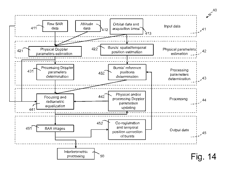
For a better understanding of the present invention, Figure 14
shows a flowchart of a method for generating SAR images
(indicated as a whole by reference numeral 40) according to a
preferred embodiment of the present invention.
In particular, the method 40 comprises:
= receiving input data (macroblock 41) related to two or
more SAR acquisitions of a same area of the earth's surface
carried out, preferably in burst mode, by one or more
satellites by means of one or more SAR sensors; said input
data conveniently comprise, for each SAR acquisition,
respective raw SAR data (block 411) (i.e. data produced by the
respective SAR sensor that performed the acquisition),
respective attitude data (block 412) indicative of respective
characteristics of the SAR acquisition (conveniently, the
pointing of the respective SAR sensor, characteristics of the
respective antenna beam used, etc.) and respective orbital
data and acquisition times (block 413), said respective
orbital data being related to the respective satellite that
carried out the SAR acquisition and said respective
acquisition times being indicative of respective temporal
characteristics of the SAR acquisition;
= estimating physical parameters (macroblock 42) of the SAR
acquisitions on the basis of the input data;
= determining processing parameters (macroblock 43) on the
basis of the physical parameters;
CA 03027670 2018-12-13
WO 2017/221166
PCT/IB2017/053689
27
= processing (macroblock 44) the input data on the basis of
the physical and processing parameters; and
= providing as output (macroblock 45) SAR images (block 451)
ready for being processed by one or more techniques of
interferometric analysis (block 50), for example for
estimating a DEM (digital elevation model), or for purposes of
differential interferometry and/or coherent change detection.
In detail, with regard to estimating the physical Doppler
parameters (macroblock 42), starting from the raw SAR data
(block 411) and the attitude data (block 412) of each single
SAR acquisition, an estimate is obtained of the physical
Doppler parameters (Doppler centroids and/or Doppler rate)
indicative of all the azimuth steering related to the single
SAR acquisitions (block 421). Furthermore, on the basis of the
orbital data and related acquisition times (block 413) of each
single SAR acquisition, the spatial position (or, in an
equivalent manner, the temporal position) of each single burst
of each single SAR acquisition (block 422) is determined.
Instead, with regard to determining the processing parameters
(macroblock 43), on the basis of the physical Doppler
parameters (Doppler centroids and Doppler rate), in particular
on the basis of the azimuth steering related to the single SAR
acquisitions, processing Doppler parameters (block 431)
(Doppler centroids and Doppler rate) are computed, which
include:
= for each SAR acquisition, respective radiometric
equalization Doppler parameters computed on the basis of the
respective physical Doppler parameters related to said SAR
acquisition, in particular on the basis of the actual pointing
of the SAR sensor when performing said SAR acquisition; and
= focusing Doppler parameters computed on the basis of the
physical Doppler parameters related to all the SAR
acquisitions.
CA 03027670 2018-12-13
WO 2017/221166
PCT/IB2017/053689
28
Conveniently, determination of the processing parameters
(macroblock 43) also includes determining an equivalent master
(in fact, if the Doppler centroid values of each acquisition
are known, it is possible to define a reference value, for
example an average value).
Furthermore, reference spatial/temporal positions of the
bursts (block 432) (for example, those that maximize
spatial/temporal overlap) are determined on the basis of the
spatial/temporal position of each single burst of each SAR
acquisition.
Instead, with regard to processing (macroblock 44), the raw
SAR data (block 411) related to the two or more SAR
acquisitions are processed on the basis of the physical
Doppler parameters, the processing Doppler parameters and the
reference spatial/temporal positions of the bursts, so as to
form SAR images (block 451). In particular, the processing
(macroblock 44) comprises (block 441):
= focusing the raw SAR data related to all the SAR
acquisitions on the basis of the focusing Doppler parameters,
in this way obtaining corresponding images (block 451) focused
in the radar domain (slant range - azimuth); and
= for each focused SAR acquisition, applying to the
respective SAR data a respective radiometric equalization
based on the respective radiometric equalization Doppler
parameters related to said SAR acquisition.
Through this processing (macroblock 44), it is possible to
obtain final products with minimal radiometric artefacts and
such that each target becomes "integrated" with the same
angles for the various acquisitions.
Furthermore, after focusing and radiometric equalization
(block 441), the estimates of the physical and/or processing
Doppler parameters can be conveniently corrected (block 442)
CA 03027670 2018-12-13
WO 2017/221166
PCT/IB2017/053689
29
for subsequent use in performing new focusing and radiometric
equalization (block 441). In particular, the physical and/or
processing Doppler parameters can be corrected by analysing
any artefact remnants in the SAR images.
In addition, the SAR images are co-registered and, after
azimuth co-registration, it is possible to estimate any burst
position errors (due, for example, to errors in the estimates
of the nominal positions of the SAR sensors) and, if
necessary, correct the reference spatial/temporal positions of
the bursts (blocks 452 and 432), and then reuse them for
performing new focusing and radiometric equalization (block
441).
In the end, final products are obtained that are compatible
with the standard algorithms for interferometric processing
(block 50).
The method 40 is preferably implemented by electronic
processing means opportunely configured and programmed to
execute the aforementioned steps of said method 40.
Conveniently, said electronic processing means are configured
to receive the input data (macroblock 41) directly from a SAR
remote sensing system and/or a database. Said electronic
processing means can be configured to provide the generated
SAR images (block 451) to a processing system for
interferometric analyses, or can be opportunely programmed to
execute one or interferometric processing operations (block
50) on the basis of said SAR images (for example, for
computing one or more heights or, more generally, for
estimating a DEM, for the purposes of differential
interferometry and/or change detection, or computing a
interferogram, a coherency map, etc.).
Obviously, although described in relation to satellite SAR
acquisitions, the method 40 can be used with both space SAR
CA 03027670 2018-12-13
WO 2017/221166
PCT/IB2017/053689
acquisitions (for example, performed by satellites or
spacecraft) and aerial SAR acquisitions (for example,
performed by planes, UAVs, helicopters, etc.).
5 In the same manner, although it has been described in relation
to SAR acquisitions in burst mode, the method 40 is obviously
usable, mutatis mutandis, also for SAR acquisitions in
stripmap and spotlight modes.
10 The technical advantages of the present invention are
immediately evident from the foregoing description.
In particular, it is important to emphasize the fact that, as
previously explained, the present invention effectively
15 overcomes the aforementioned limitations of the currently
known techniques because it is capable of ensuring spectral
overlap even if it is physically absent.
It is also important to note that no known technique uses
20 different Doppler parameters for focusing and for radiometric
compensation due to the azimuth antenna pattern.
In particular, the aforementioned article "Burst-Mode and
ScanSAR Interferometry" proposes the use, as in the present
25 invention, of the same centroids for processing raw data, but,
unlike the present invention, it renounces to compensating
radiometric aberrations (scalloping) due to the antenna
pattern, introducing decorrelation phenomena
and,
consequently, differences between the images that reduce the
30 performance of the final interferometric products. In
addition, it is important to stress that "Burst-Mode and
ScanSAR Interferometry" makes no mention whatsoever of using a
same Doppler rate, deals exclusively with the ScanSAR mode and
in no way, postulates the use of double parameters for
focusing and for radiometric compensation (which is not
implemented).
CA 03027670 2018-12-13
WO 2017/221166
PCT/IB2017/053689
31
As previously explained, also "Optimal "focusing' for low
resolution ScanSAR" teaches the use of a single set of
processing parameters, while the possibility of using two
distinct sets of processing parameters (one for focusing and
one for radiometric equalization) is neither contemplated nor
postulated whatsoever in said article.
In particular, in several parts of "Optimal "focusing' for low
resolution ScanSAR", the authors talk of a single set of
focusing parameters for each acquisition, while no technique
is introduced to compensate for possible differences in
azimuth steering between the various interferometric
acquisitions.
In detail, in "Optimal "focusing' for low resolution ScanSAR",
the Doppler centroid is considered to be a specific single
parameter of each acquisition that has a single value (in
particular, the Doppler centroid is assumed equal to zero as
an acquisition geometry of the "zero Doppler" type is assumed
in the article).
The same also applies to the Doppler rate, which in "Optimal
"focusing" for low resolution ScanSAR" is considered a single
parameter.
This article does not provide any solution to the problem
related to SAR acquisitions performed using different azimuth
acquisition directions (i.e. using different squint angles).
In particular, in paragraph V-A of "Phase Preserving
Processing", on page 487 of "Optimal "focusing' for low
resolution ScanSAR" it is stated: "An important factor of the
final interferometric quality is processor phase distortion.
In low TBPaz [Azimuth Time Bandwidth Product] ScanSAR
interferometry, a decorrelation source is introduced by a
CA 03027670 2018-12-13
WO 2017/221166
PCT/IB2017/053689
32
different FIRF [Focused Impulse Response Function] shape in
the two co-registered focused images. This may be the case
when the two AAP [Azimuth Antenna Pattern] are shifted or when
one of the two images is synthesized from a SAR focused image
This paragraph V-A of "Optimal "focusing' for low resolution
ScanSAR" is the only part of the article in which the relation
between different acquisitions for interferometric purposes is
discussed. Decorrelation due to the use of different azimuth
antenna patterns is mentioned in "Optimal "focusing' for low
resolution ScanSAR" as a constraint, without any solution
being provided for the compensation of this decorrelation. In
fact, in the same paragraph (i.e. V-A) of "Optimal "focusing'
for low resolution ScanSAR", the authors state: "In this case
the NIMSE [Minimum Mean Square Error] solution gives a
decorrelation comparable to that achieved by a cosine windowed
reference, however NIMSE performs better since it explores a
larger bandwidth.".
In summary, the technique proposed in "Optimal "focusing' for
low resolution ScanSAR" does not introduce additional phase
noise, but, unlike the present invention, neither does it
provide any solution for compensating the phase distortion of
interferometric acquisitions carried out using different
azimuth acquisition directions (i.e. using different squint
angles).
As additional proof of what has just been explained, it is
important to note that Table II on page 482 of "Optimal
"focusing" for low resolution ScanSAR" lists the values of the
single set of parameters used for ScanSAR focusing (in which a
single Doppler rate is indicated, while no Doppler centroid is
indicated as it is assumed to be zero). In this way, the
processing parameters (specifically, the focusing parameters)
used in "Optimal "focusing' for low resolution ScanSAR" can
CA 03027670 2018-12-13
WO 2017/221166
PCT/IB2017/053689
33
change for each interferometric acquisition (in the case where
the azimuth acquisition geometry changes). These focusing
parameters used in "Optimal "focusing' for low resolution
ScanSAR" correspond, in substance, to the aforementioned
specific physical Doppler parameters of each acquisition that,
according to the present invention, are used to calculate, for
each acquisition, the aforementioned double set of processing
parameters, namely:
= the aforementioned focusing Doppler parameters that are
the same for all the SAR acquisitions and computed on the
basis of the physical Doppler parameters related to all of the
SAR acquisitions; and
= the aforementioned respective radiometric equalization
Doppler parameters that are related to said SAR acquisition
and computed on the basis of the respective physical Doppler
parameters related to said SAR acquisition.
Moreover, it should also be noted that neither
"Interferometric Processing of SLC Sentinel-1 TOPS Data", nor
"Interferometric TOPS Chain Description", nor even "TOPS
Imaging With TerraSAR-X: Mode Design and Performance Analysis"
postulate the use of double parameters for focusing and for
radiometric compensation.
In summary, the Doppler shift between different
interferometric acquisitions causes decorrelation. As
previously explained, in order to handle this decorrelation,
the traditional literature teaches the use of so-called common
band filtering, but this technique causes azimuth resolution
degradation, degradation that cannot be dealt with for
acquisitions performed in burst mode (for example in ScanSAR
mode).
Conversely, the present invention teaches to process each
acquisition using two different sets of processing parameters;
in particular, a same set of focusing parameters is used for
CA 03027670 2018-12-13
WO 2017/221166
PCT/IB2017/053689
34
focusing raw SAR data related to all the SAR acquisitions to
be processed, while for each SAR acquisition, a respective
radiometric equalization based on a respective set of
parameters of radiometric equalization related to said SAR
acquisition is also performed to compensate for possible
pointing differences of the SAR sensor(s) used for carrying
out the various SAR acquisitions, without degrading azimuth
resolution and without introducing radiometric distortions
(i.e. without introducing degradation in radiometric
performance).
In other words, by resolving the problems due to the different
acquisition geometry at the origin, the present invention
cancels problems due to different attitude or difference in
Doppler rate between the various acquisitions, thus
guaranteeing spectral overlap even when physically absent and
overcoming the aforementioned limitations of the currently
known techniques.
It is also important to note that further technical advantages
of the present invention derive from the possibility of
correcting (block 442 in Figure 14) the estimates of the
physical and/or processing Doppler parameters (i.e. the
focusing and radiometric equalization parameters) after
focusing and radiometric equalization (block 441 in Figure
14), for example, by analysing possible artefact remnants in
the SAR images. In this way, it is possible to iteratively
perform the processing (i.e. the focusing and radiometric
equalization - block 441 in Figure 14), progressively refining
the estimate of the physical and/or processing Doppler
parameters (i.e. the focusing and radiometric equalization
parameters - block 442 in Figure 14) and, consequently,
progressively improving the quality of the final products
(i.e. the generated SAR images - block 451 in Figure 14).
CA 03027670 2018-12-13
WO 2017/221166
PCT/IB2017/053689
Furthermore, as previously explained, after azimuth co-
registration of the SAR images, according to the present
invention it is also possible to estimate possible burst
position errors (due, for example, to errors in the estimates
5 of the nominal positions of the SAR sensors) and, if
necessary, correct the reference spatial/temporal positions of
the bursts (blocks 452 and 432 in Figure 14), and then use
them for performing new focusing and radiometric equalization
(block 441).
In conclusion, it is clear that various modifications can be
applied to the present invention without departing from the
scope of the invention as defined in the appended claims.