Note: Descriptions are shown in the official language in which they were submitted.
CALIBRATION OF ELECTROMAGNETIC RANGING TOOLS
TECHNICAL FIELD
[0001] The present disclosure relates to a system and method for
electromagnetic ranging.
Specifically, methods and systems may be disclosed for in situ calibration of
an electromagnetic ranging
tool.
BACKGROUND
[0002] Wellbores drilled into subterranean formations may enable recovery of
desirable fluids
(e.g., hydrocarbons) using a number of different techniques. Knowing the
location of a target wellbore
may be important while drilling a second wellbore. For example, in the case of
a target wellbore that may
be blown out, the target wellbore may need to be intersected precisely by the
second (or relief) wellbore
in order to stop the blow out. Another application may be where a second
wellbore may need to be drilled
parallel to the target wellbore, for example, in a steam-assisted gravity
drainage ("SAGD") application,
wherein the second wellbore may be an injection wellbore while the target
wellbore may be a production
wellbore. Yet another application may be where knowledge of the target
wellbore's location may be
needed to avoid collision during drilling of the second wellbore.
[0003] Electromagnetic ranging tools may be employed in subterranean
operations to determine
direction and distance between two wellbores. Electromagnetic ranging tools
may use different
techniques to obtain current on a conductive member in the target wellbore.
Without limitation,
approaches may include directly injecting a current into the conductive member
and/or inducing a current
on a conductive member by transmitting electromagnetic waves by coil antennas
positioned in a second
wellbore. The induced current in turn may cause the casing to radiate a
secondary electromagnetic field.
In another approach, an electrode type source may be used to induce current on
the conductive member.
The gradient of the magnetic field radiated by the conductive member in
addition to the magnetic field
itself may be measured. Using a relationship between the magnetic field and
its gradient, a ranging
measurement may be calculated. However, use of gradient calculations may be
problematic as an infinite
pipe with a constant induced current may be assumed, which may lead to larger
errors in determining
range. Alternatively, an inversion may be used to determine the range, in
which a forward model of the
signal that may be received at the ranging tool may be needed. The inversion
process may try to find the
formation and well parameters that would match the forward model with the
measurements made by the
tool. However, use of the inversion process may be problematic as the gain of
the electromagnetic
ranging tool may be different from that used in the forward model.
CA 3029187 2020-02-12
CAN_DMS: \131976744\1 1
SUMMARY
[0003a] In accordance with a general aspect, there is provided a method
comprising:
disposing an electromagnetic ranging tool into a wellbore; measuring a first
set of signals with
the electromagnetic ranging tool at a first position within the wellbore;
calculating a modeled
signal; determining if a target well is present from the first set of signals
and the modeled signal;
determining a gain coefficient as a ratio of the modeled signal to the first
set of signals if the
target well is not present; and setting a gain offset to zero.
[0003b] In accordance with another aspect, there is provided an
electromagnetic
ranging system comprising: an electromagnetic ranging tool comprising: a
transmitter configured
to transmit an electromagnetic signal; a receiver configured to record a first
set of signals; and an
information handling system coupled to the electromagnetic ranging tool,
wherein the
information handling system is operable to: calculate a modeled signal;
determine if a target well
is present from the first set of signals and the modeled signal; determine a
gain coefficient as a
ratio of the modeled signal to the first set of signals if the target well is
not present; and setting a
gain offset to zero.
[0003c] In accordance with a further aspect, there is provided a
method
comprising: disposing an electromagnetic ranging tool into a wellbore;
measuring a first set of
signals with the electromagnetic ranging tool at a first position within the
wellbore; calculating a
first modeled signal; determining if a target well is present based on the
first set of signals and
the first modeled signal; storing the first set of signals and the first
modeled signal if the target
well is not present; moving the electromagnetic ranging tool in the wellbore;
measuring a second
set of signals with the electromagnetic ranging tool at a second position
within the wellbore if the
target well is not present; calculating a second modeled signal and the second
position;
determining if the target well is present based on the second set of signals
the second modeled
signal; determining a gain coefficient, if the target well is not present, as
a ratio a difference of
the second modeled signal and the first modeled signal to a difference of the
second set of
signals and the first set of signals; and determining a gain offset, if the
target well is not present,
as a difference between the second modeled signal and the gain coefficient
multiplied by the
second set of signals.
CA 3029187 2020-02-12
CAN_DMS: \131976744\1 1a
CA 03029187 2018-12-21
WO 2018/063162
PCMJS2016/053986
BRIEF DESCRIPTION OF THE DRAWINGS
[0004] These drawings illustrate certain aspects of some of the examples of
the
present invention, and should not be used to limit or define the invention.
[0005] Figure 1 illustrates use of an example of an electromagnetic ranging
system in
a wellbore;
[0006] Figure 2 is a block diagram of an example electromagnetic ranging
system;
[0007] Figure 3 illustrates use of an example electromagnetic ranging tool for
coil
excitation;
[0008] Figure 4 illustrates use of an example electromagnetic ranging tool for
electrode excitation;
[0009] Figure 5 illustrates ranging geometry for use in inversion;
[0010] Figure 6 illustrates an example of an electromagnetic ranging tool with
a
resistivity tool;
[0011] Figure 7 illustrates an example of surface calibration of an
electromagnetic
.. ranging tool;
[0012] Figure 8 illustrates another example of surface calibration of an
electromagnetic ranging tool;
[0013] Figure 9 illustrates a method for determining if target wellbore is
present;
[0014] Figure 10 illustrates a method for validating the method in Figure 9,
assuming
a homogeneous formation model;
[0015] Figure 11 illustrates a method for validating the method in Figure 9,
assuming
a inhomogeneous formation model; and
[0016] Figure 12 illustrates a method for in situ calibration of an
electromagnetic
ranging tool.
DETAILED DESCRIPTION
[0017] The present disclosure relates generally to a system and method for
calibrating
an electromagnetic ranging system. More particularly, the electromagnetic
ranging system
may be calibrated in situ, for example, during drilling operations, and
optionally on the surface.
Calibration of the electromagnetic ranging system may help in determining the
orientation and
position of an underground well accurately and efficiently. An electromagnetic
ranging
system may comprise an electromagnetic ranging tool, which may comprise a
transmitter
and/or receiver. Transmission of electromagnetic fields by the transmitter and
recording of
signals by the receiver may be controlled by an information handling system.
2
CA 03029187 2018-12-21
WO 2018/063162
PCT/US2016/053986
[0018] Certain examples of the present disclosure may be implemented at least
in part
with an information handling system. For purposes of this disclosure, an
information handling
system may include any instrumentality or aggregate of instrumentalities
operable to compute,
classify, process, transmit, receive, retrieve, originate, switch, store,
display, manifest, detect,
record, reproduce, handle, or utilize any form of information, intelligence,
or data for
business, scientific, control, or other purposes. For example, an information
handling system
may be a personal computer, a network storage device, or any other suitable
device and may
vary in size, shape, performance, functionality, and price. The information
handling system
may include random access memory (RAM), one or more processing resources such
as a
central processing unit (CPU) or hardware or software control logic, ROM,
and/or other types
of nonvolatile memory. Additional components of the information handling
system may
include one or more disk drives, one or more network ports for communication
with external
devices as well as various input and output (I/O) devices, such as a keyboard,
a mouse, and a
video display. The information handling system may also include one or more
buses operable
to transmit communications between the various hardware components.
[0019] Certain examples of the present disclosure may be implemented at least
in part
with non-transitory computer-readable media. For the purposes of this
disclosure, non-
transitory computer-readable media may include any instrumentality or
aggregation of
instrumentalities that may retain data and/or instructions for a period of
time. Non-transitory
computer-readable media may include, for example, without limitation, storage
media such as
a direct access storage device (e.g., a hard disk drive or floppy disk drive),
a sequential access
storage device (e.g., a tape disk drive), compact disk, CD-ROM, DVD, RAM, ROM,
electrically erasable programmable read-only memory (EEPROM), and/or flash
memory; as
well as communications media such wires, optical fibers, microwaves, radio
waves, and other
electromagnetic and/or optical carriers; and/or any combination of the
foregoing.
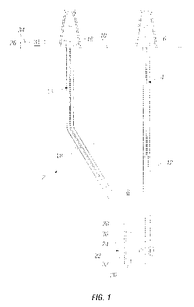
[0020] Figure 1 illustrates an electromagnetic ranging system 2. As
illustrated, a
target wellbore 4 may extend from a first wellhead 6 into a subterranean
formation 8 from a
surface 10. Generally, target wellbore 4 may include horizontal, vertical,
slanted, curved, and
other types of wellbore geometries and orientations. Target wellbore 4 may be
cased or
uncased. A conductive member 12 may be disposed within target wellbore 4 and
may comprise
a metallic material that may be conductive. By way of example, conductive
member 12 may
be a casing, liner, tubing, or other elongated metal tubular disposed in
target wellbore 4.
Determining the position and direction of target wellbore 4 accurately and
efficiently may be
required in a variety of applications. For example, target wellbore 4 may be a
"blowout- well.
Target wellbore 4 may need to be intersected precisely by a second wellbore 14
in order to
3
CA 03029187 2018-12-21
WO 2018/063162
PCT/US2016/053986
stop the "blowout." Alternatively, it may be desired to avoid collision with
target wellbore 4
in drilling second wellbore 14 or it may be desired to drill the second
wellbore parallel to the
target wellbore 4, for example, in SAGD applications. In examples, target
wellbore 4 may not
be accessible and/or information about the position and structure of target
wellbore 4 may not
be available. As will be discussed in more detail, electromagnetic ranging
system 2 may be
used for determining the location of target wellbore 4 with respect to second
wellbore 14.
[0021] With continued reference to Figure I, second wellbore 14 may also
extend
from a second wellhead 16 that extends into subterranean formation 8 from
surface 10.
Generally, second wellbore 14 may include horizontal, vertical, slanted,
curved, and other
types of wellbore geometries and orientations. Additionally, while target
wellbore 4 and
second wellbore 14 are illustrated as being land-based, it should be
understood that the present
techniques may also be applicable in offshore applications. Second wellbore 14
may be cased
or uncased. In examples, a drill string 18 may begin at second wellhead 16 and
traverse second
wellbore 14. A drill bit 20 may be attached to a distal end of drill string 18
and may be driven,
for example, either by a downhole motor and/or via rotation ofdrill string 18
from surface 10.
The drill bit 20 may be a part of bottom hole assembly 22 at distal end of
drill string 18. While
not illustrated, bottom hole assembly 22 may further comprise one or more of a
mud motor,
power module, steering module, telemetry subassembly, and/or other sensors and
instrumentation as will be appreciated by those of ordinary skill in the art.
As will be
appreciated by those of ordinary skill in the art, bottom hole assembly 22 may
be a
measurement-while drilling or logging-while-drilling system.
[0022] Without limitation, electromagnetic ranging system 2 may comprise an
electromagnetic ranging tool 24. Electromagnetic ranging tool 24 may be a part
of bottom
hole assembly 22. Electromagnetic ranging tool 24 may be used for determining
the distance
and direction to target wellborc 4. Additionally, electromagnetic ranging tool
24 may be
connected to and/or controlled by information handling system 26, which may be
disposed on
surface 10. In examples, information handling system 26 may communicate with
electromagnetic ranging tool 24 through a communication line (not illustrated)
disposed in (or
on) drill string 18. In examples, wireless communication may be used to
transmit information
back and forth between information handling system 26 and electromagnetic
ranging tool 24.
Information handling system 26 may transmit information to electromagnetic
ranging tool 24
and may receive as well as process information recorded by electromagnetic
ranging tool 24.
In addition, electromagnetic ranging tool 24 may include a downhole
information handling
system 28, which may also be disposed on bottom hole assembly 22. Downhole
information
handling system 28 may include, without limitation, a microprocessor or other
suitable
4
CA 03029187 2018-12-21
WO 2018/063162
PCT/US2016/053986
circuitry, for receiving and processing signals received by the
electromagnetic ranging tool 24.
Downhole information handling system 28 may further include additional
components, such
as memory, input/output devices, interfaces, and the like. While not
illustrated, the
electromagnetic ranging tool 24 may include one or more additional components,
such as
analog-to-digital converter and amplifier, among others, that may be used to
process the
measurements of the electromagnetic ranging tool 24 before they may be
transmitted to surface
10. Alternatively, raw measurements from electromagnetic ranging tool 24 may
be transmitted
to surface 10.
[0023] In examples, electromagnetic ranging tool 24 may comprise a transmitter
30
and/or a receiver 32. It should be noted that electromagnetic ranging tool 24
may comprise a
plurality of transmitters 30 and/or a plurality of receivers 32. The
transmitter 30 and receiver
32 may be disposed along a longitudinal axis of the electromagnetic ranging
tool 24. Any of a
variety of different transmitters 30 and receivers 32 for generating and
measuring
electromagnetic fields may be suitable for use, including, but not limited to,
coil antenna, wire
antenna, toroidal antenna and/or azimuthal button electrodes. Magnetometers
may also be
used as the receiver 30. Without limitation, transmitter 30 may be energized,
which may be
controlled by information handling system 26 and/or downhole information
handling system
28, to produce a magnetic field that may be emitted into subterranean
formation 8. The
magnetic field may energize conductive member 12 within target wellbore 4 by
inducing eddy
currents in conductive member 12. While Figure 1 shows transmitter 30 on
electromagnetic
ranging tool 24, transmitter 30 may be omitted and conductive member 12 may be
energized
using alternative techniques, such as by coupling a current source directly to
conductive
member 12 to generate currents. The currents within conductive member 12 may
in turn
produce a secondary magnetic field. This secondary magnetic field may radiate
from target
wellbore 4. In examples, the secondary magnetic field may induce voltages in
receiver 30 that
may be recorded and transmitted to surface 10. Using these recorded voltages,
the location of
target wellbore 4 may be determined. By way of example, the direction and
distance of target
wellbore 4 may be determined with respect to second wellbore 14.
[0024] Any suitable technique may be used for transmitting signals from
electromagnetic ranging tool 24 to surface 10, including, but not limited to,
mud-pulse
telemetry, acoustic telemetry, and electromagnetic telemetry. While not
illustrated, bottom
hole assembly 22 may include a telemetry subassembly that may transmit
telemetry data to the
surface. Without limitation, a transmitter in the telemetry subassembly may be
operable to
generate pressure pulses in the drilling fluid that propagate along the fluid
stream to surface
10. At surface 10, pressure transducers (not shown) may convert the pressure
signal into
5
CA 03029187 2018-12-21
WO 2018/063162
PCT/US2016/053986
electrical signals for a digitizer 31. Digitizer 31 may supply a digital form
of the telemetry
signals to information handling system 26 via a communication link 34, which
may be a wired
or wireless link. The telemetry data may be analyzed and processed by
information handling
system 26. For example, the telemetry data could be processed to determine
location of target
wellbore 4. With the location of target wellbore 4, a driller could control
the bottom hole
assembly 22 while drilling second wellbore 14 to intentionally intersect
target wellbore 4,
avoid target wellbore 4, and/or drill second wellbore 14 in a path parallel to
target wellbore 4.
[0025] To accurately determine the position of target wellbore 4, including
distance
and direction, electromagnetic ranging system 2 may be calibrated to ensure
accurate
measurements. For example, calibrated signals may be used to determine a
location of target
wellbore 4. Based on the calibrated signal, drilling parameters of second
wellbore 14 may be
adjusted, for example, to cause bottom hole assembly 22 to intentionally
intersect target
wellbore 4, avoid target wellbore 4, and/or drill second wellbore 14 in a path
parallel to target
wellbore 4. Calibration may be performed to take into account the gain within
electromagnetic
ranging system 2. This is because the gain of the electromagnetic ranging
system 2 may differ
from the gain used in the forward model for inversion, the gain may differ
between different
electromagnetic ranging tools 24 even if they have the same design, and the
same
electromagnetic ranging tool 24 may even needed to be re-calibrated for
different runs due to
differences in gain.
[0026] As disclosed, gain represents the mismatch between the measurements
taken
and the derived model. Gain may fluctuate over time, if these gain fluctuation
are not
corrected, then they may produce errors in the determination of the location
of a target
wellbore 4. This may reduce accuracy, which may be particularly important in
well avoidance
applications where the position of a target wellbore 4 may be determined in
advance and the
drilling path may be changed based on measurements from electromagnetic
ranging tool 24.
Additionally, in well intersection applications, a slight mistake may only
aggravate the
situation. Gain may vary between different devices within electromagnetic
ranging system 2,
which may make it difficult to properly account for gain in a forward model.
Thus,
recalibration may be performed before, during, and/or after an operation in
which
electromagnetic ranging system 2 may be used.
[0027] The calibration method may include an in situ calibration. In general,
the
calibration method may use known formation properties to calculate and correct
gain where
the target wellbore 4 is not present. The target wellbore 4 may be considered
to not be present
if the secondary magnetic fields emanating from it may be considered
negligible compared to
noise. The calibration method may be performed using information handling
system 26 at
6
CA 03029187 2018-12-21
WO 2018/063162
PCT/US2016/053986
surface 10, downhole information handling system 28, or a combination of
information
handling system 26 and downhole information handling system 28. The in situ
calibration
may include positioning the electromagnetic ranging tool 24 in a wellbore,
such as second
wellbore 14 and then using the electromagnetic ranging tool 24 to generate an
electromagnetic
.. field that emanates into subterranean formation 8. Receiver 30 may then be
used to measure
the electromagnetic field. Based on these measurements, and assuming a linear
relation
between model and the measurement, a gain coefficient may be calculated and
applied to
subsequent measurements. Optionally, a gain offset may also be calculated, in
addition to the
gain coefficient, and applied to subsequent measurements. Surface calibration
may be
combined with the in-situ calibration to maintain an accurate calibration
during
electromagnetic ranging operations.
[0028] Referring now to Figure 2, a block diagram illustrating an example of
electromagnetic ranging system 2 is illustrated. As illustrated, the
electromagnetic ranging
system 2 may comprise an electromagnetic ranging tool 24 that comprises a
transmitter 30 and
receiver 32. More than one transmitter 30 and more than one receiver 32 may
also be used.
The transmitter 30 may be coupled to transmitter electronics 36 and receiver
32 may be
coupled to receiver electronics 38. The transmitter electronics 36 and
receiver electronics 38
may include a variety of components, including analog-to-digital converters
and amplifiers.
Electromagnetic ranging tool 24 may be operable to generate and measure
electromagnetic
.. fields.
[0029] Electromagnetic ranging system 2 may further comprise information
handling
system 26 and downhole information handling system 28. As previously
described,
information handling system 26 may be disposed at surface 10 (e.g., shown on
Figure 1). The
downhole information handling system 28, whether alone or in combination with
information
handling system 26, may be arranged to operate to control operation of
electromagnetic
ranging tool 24 and to perform operations on the signals collected by receiver
32 to calibrate
the electromagnetic ranging system 2. The downhole information handling system
28,
whether alone or in combination with information handling system 26, may be
operable to
perform operations according to the calibration disclosed herein. By way of
example,
downhole information handling system 28, whether alone or in combination with
information
handling system 26, may include instructions stored thereon that when executed
cause the
downhole information handling system 28 to perform operations according to the
disclosed
calibration method. The downhole information handling system 28, whether alone
or in
combination with information handling system 26, may control activation of
transmitter 30 to
generate a signal for calibration and also control selection of receiver 32 to
manage processing
7
CA 03029187 2018-12-21
WO 2018/063162
PCT/US2016/053986
schemes. Information handling system 26, whether alone or in combination with
downhole
information handling system 28, may be operable to process measurements from
receiver 32
to determine location of target wellbore 4. As illustrated, peripheral devices
40, such as a
display unit (e.g., computer monitor) or input/out devices may be coupled to
information
handling system 26 at surface 10.
[0030] Electromagnetic ranging system 2 may further include a bus 42, where
bus 42
may provide electrical conductivity between electromagnetic ranging tool 24
and downhole
information handling system 28, for example. The bus 42 may include an address
bus, a data
bus, and a control bus, each independently configured or in an integrated
format. The bus 42
may be realized using a number of different communication mediums that allow
for the
distribution of components of electromagnetic ranging system 2. Use of bus 42
may be
regulated by downhole information handling system 28. Bus 42 may include a
communication
network.
[0031] The electromagnetic ranging system 2 may further include a telemetry
subassembly 44, which may utilize any suitable technique for transmitting
signals from
downhole information handling system 28 to information handling system 26 at
surface 10,
including, but not limited to, mud-pulse telemetry, acoustic telemetry, and
electromagnetic
telemetry. By way of example, telemetry subassembly 44 may be operable to
generate
pressure pulses in the drilling fluid that propagate along the fluid stream to
surface 10.
[0032] The principles of operation of electromagnetic ranging tool 24 will now
be
described in more detail with respect to Figures 3 and 4. Figure 3 illustrates
the use of
electromagnetic ranging tool 24 for coil excitation, and Figure 4 illustrates
the use of
electromagnetic ranging tool 24 for electrode excitation. For simplicity,
target wellbore 4 and
second wellbore 14 are not shown in Figures 3 and 4, but electromagnetic
ranging tool 24 may
be disposed in second wellbore 14 and conductive member 12 may be disposed in
target
wellbore 4 as illustrated on Figure 1. In both Figures 3 and 4, a cross-
section of subterranean
formation 8 in the x-z plane is shown in which subterranean formation 8 is
assumed to be a
homogeneous formation
[0033] Referring now to Figure 3, transmitter 30 in the form of a transmitting
coil
with a magnetic moment in the y-direction (e.g., a coil that lies in the x-z
plane) may induce
an electric field (E) in subterranean formation 8. The electric field lines 46
are provided on
Figure 3. As illustrated, conductive member 12 may be present and have its
principal axis
lying in the z-direction. Since the conductive member 12 may be more
conductive than
subterranean formation 8 surrounding it, a strong coupling of the electric
field (E) to the
conductive member 12 may occur. This coupling may produce a conductive current
8
CA 03029187 2018-12-21
WO 2018/063162
PCT/US2016/053986
(represented by current lines 48) on the conductive member 12 and in turn a
secondary
magnetic field. As illustrated, by secondary magnetic field lines 50, the
secondary magnetic
field may be represented as concentric closed loops in a homogenous formation.
[00341 Turning now to Figure 4, use of electromagnetic ranging tool 24 for
electrode
excitation will now be described. As illustrated, transmitter 30 in the form
of an electrode may
induce an electric field (E.) with electric field lines 46 that emanate
directly into subterranean
formation 8. As illustrated, conductive member 12 may be present and have its
principal axis
lying in the z-direction. Similar to coil excitation, the electric field (E)
may couple to
conductive member 12 and produce a conductive current (represented by current
lines 48) on
the conductive member 12. However, due to the difference in shape of the
electric field lines
46 for coil excitation and electrode excitation, the direction of the
conductive current may be
different on conductive member 12. The current on conductive member 12 may in
turn
generate a secondary magnetic field (e.g., represented by secondary magnetic
field lines 50)
that emanates into subterranean formation 8.
100351 For both coil excitation and electrode excitation, the magnitude of the
secondary magnetic field around conductive member 12 may be found via the Biot-
Savart law.
It should be noted that Figures 3 and 4 only illustrate secondary magnetic
field lines 50 in a
limited space, for simplicity. If the induced current on conductive member 12
was constant,
the Biot-Savart law would reduce to Ampere's law, such as the one shown in
Equation 1
below:
01/4
H
2727
(1)
Wherein r is the radial distance from the target wellbore 4 to the measurement
point (i'-)
assuming a cylindrical coordinate system where the z-axis coincides with the
axis of the
cylinder, is a unit
vector in azimuthal direction for this coordinate system, and H is the
magnetic field at point (0. The equation may be used in electromagnetic
ranging tools, such
as electromagnetic ranging tool 24, to calculate gradient of the received
field in addition to the
electromagnetic field itself and calculating the distance to the target
wellbore 4 by taking a
ratio of the gradient and the electromagnetic field. However, to avoid errors
due to
assumptions that induce current on conductive member 12 may be constant,
inversion may be
used.
9
CA 03029187 2018-12-21
WO 2018/063162
PCT/US2016/053986
[0036] Referring now to Figure 5, ranging geometry is illustrated that may be
used for
constructing an example inversion. As illustrated, electromagnetic ranging
tool 24 may be
disposed in second wellbore 14 for use in determination location of target
wellbore 4. In
examples, location of target wellbore 4 may be determined with respect to
second wellbore
14. Electromagnetic ranging tool 24 may be assumed to be in the z-direction in
the Cartesian
coordinate system. Target wellbore 4 may be at a distance D away from a
reference point on
bottom hole assembly 22. In this example, the reference point may be the tip
of drill bit 20.
The inclination and azimuth of target wellbore 4 with respect to
electromagnetic ranging tool
24 may be shown as 0 and respectively, and if may be a unit vector parallel to
a direction of
target wellbore 4. The drilling mud in second wellbore 14 may have a mud
resistivity of Rm.
Second wellbore 14 may have a diameter of dbh. Subterranean formation 8 may
have a
resistivity of Rf.
[0037] Based on the ranging geometry illustrated on Figure 5, an example
inversion
may be constructed to solve for parameters (D, 0, and ii). This may be a total
of 5 parameters,
.. for example, as the unit vector (n) may be defined using two of its
components. An iterative
type of inversion may be used or a look-up library search of proprietary
information may be
employed. As previously noted, inversion may use a forward model that
simulates the signal
that would be measured at receiver 32 of electromagnetic ranging tool 24 for a
specific target
well position and orientation. Parameters such as formation resistivity Rf,
mud resistivity Rm,
.. and borehole diameter dbh may be found using other tools are assumed to be
known for the
inversion. Additional parameters that may impact the measurements may also be
incorporated
into the forward model such as the target wellborc 4 diameter, target wellbore
4 resistivity,
and permeability, but they are not discussed herein for simplicity. The
inversion may then be
implemented to find the parameters that minimize a cost function, wherein the
cost
function may be the difference between the forward model and actual
measurements
recorded by electromagnetic ranging system 2.
[0038] In an iterative inversion, whenever a measurement may be made at the
receiver 32 of the electromagnetic ranging tool 24 (e.g., which may be written
as the
matrix an initial guess of the target wellbore 4 position may be made and
using other
parameters, for example, that may be assumed to be known. Based on the value
of the
cost function, an updated guess may be calculated until the iteration
converges to a
solution or a maximum number of iterations is achieved. It should be noted
that the
measured signal S may include different transmitter-receiver configurations
and different
operating frequencies, among others. Furthermore, in logging-while-drilling
systems, for
CA 03029187 2018-12-21
WO 2018/063162
PCT/US2016/053986
example, the measured signal g may also include measurements at different
azimuthal
bins or this azimuthal information may be averaged out. In an inversion
utilizing
proprietary information, cost functions between the measured signal g and a
library of
modelling results (e.g., modeled signals M) may be calculated and then a
parameter set
that corresponds to the minimum cost function may be returned as the answer,
for
example.
[0039] As described above in the description of inversion, parameters, without
limitation, such as mud resistivity, formation resistivity, and second
wellbore 14 diameter,
may be found and placed into a forward model. In the following paragraphs,
various non-
limiting techniques for determination of mud resistivity, formation
resistivity, and second
wellbore 14 diameter will be described. It should be understood that the
following
description is merely illustrative and other techniques may be used to
calculate these
parameters.
[0040] An example technique for determining second wellbore 14 diameter may
use a caliper tool. By way of example, a caliper tool (not illustrated) may be
disposed on
bottom hole assembly 22 and used to measure the diameter of second wellbore
14. The
caliper tool may comprise several legs, which may be opened to touch the wall
of second
wellbore 14. Based on the distance the legs may open, the second wellbore 14
diameter
may be accurately measured and logged. The caliper tool may also be used to
provide
information related to eccentricity and caving, which may further be
incorporated into a
forward model.
[0041] An example technique for measuring mud resistivity may use a mud
sensor.
In examples, the mud sensor may have a very shallow depth of investigation.
The mud sensor
may emit a current into second wellbore 14 and measure the voltage drop to
calculate mud
resistivity. The mud resistivity may then be placed into the forward model.
[0042] An example technique for measuring formation resistivity may use a
resistivity
tool. Figure 6 illustrates inclusion of a resistivity tool 52 on bottom hole
assembly 22. As
illustrated, resistivity tool may be disposed between various sections of
electromagnetic
ranging tool 24, such as between transmitter 30 and receiver 32. Resistivity
tool 52 may
be an azimuthal and/or non-azimuthal propagation resistivity tool. To
prevent
interference between different tools, frequency of operation of resistivity
tool 52 and
electromagnetic ranging tool 24 may be selected to be different. Different
frequencies of
operation may also be required because the sensitivity to a formation and
target well
resistivity may be optimal at different frequencies. Filtering may be applied
to reduce the
interference further, and gap subs may be used to minimize coupling between
11
CA 03029187 2018-12-21
WO 2018/063162
PCT/US2016/053986
electromagnetic ranging tool 24 and resistivity tool 52. In examples,
resistivity tool 52
may have a volume that may be sensitive to the properties of a formation,
illustrated as
reference number 54 on Figure 6, which may be different than the sensitive
volume of
electromagnetic ranging tool 24. Although subterranean formation 8 may be
shown to be
homogeneous, it should be understood that subterranean formation 8 may
comprise
different layers. Resistivity tool 52 (e.g., a propagation resistivity tool)
may have a depth
of investigation that may be less than twenty feet. To find formation
resistivity at
locations that may be further than 20 feet from resistivity tool 52, an
interpolation may be
performed, for example, using a geological model and the resistivity
information from
resistivity tool 52. Additionally, resistivity tool 52 may have different
modes of operation
with different depths of investigation that may benefit interpolation. Thus,
the resistivity
of subterranean formation 8 may be measured and used within forward modeling.
[0043] As previously described, gain of electromagnetic ranging system 2 may
fluctuate over time and, if not corrected, may produce error in the determined
position of
target wellbore. In addition to in situ calibration, surface calibration may
also be used,
for example, to determine proper operation of electromagnetic ranging system
2. Surface
calibration may be useful, for example, in early stages of tool deployment
before in situ
calibration may be available. Additionally, surface calibration may also
ensure that the
forward model used in subsequent in situ calibration does not have a large
error at the
beginning. Surface calibration may be performed by many different methods for
coil and
electrode type electromagnetic excitations. For example, electrode excitation
may depend on
galvanic principles, a resistor box may be used for calibration of the
electrodes on the surface.
Coil excitation may depend on induction principles, a calibration test coil
may be used to
calibrate electromagnetic ranging system 2 with coils on the surface.
[0044] Figure 7 illustrates an example surface calibration of an
electromagnetic
ranging tool 24 that may include electrode excitation. As illustrated, the
electromagnetic
ranging tool 24 may include a transmitter 30 and receivers 32. The transmitter
30 may include
a source electrode 56 and a return electrode 58. A resistor box 60 may be
connected between
source electrode 56 and a return electrode 58. A voltage and/or a current may
be applied
between the source electrode and the return electrode, allowing for the
measurement of a
complex impedance. The properties of resistor box 60 may be known, which may
allow an
operator to model the expected response of electromagnetic ranging system 2.
For example,
an ideal current level that may be transmitted within electromagnetic ranging
tool 24, when
resistor box 60 may be connected, may be a known value. If the actual current
level is
different, electromagnetic ranging tool 24 may be adjusted accordingly to
increase and/or
12
CA 03029187 2018-12-21
WO 2018/063162
PCT/US2016/053986
decrease the gain within electromagnetic ranging tool 24. Additionally,
electromagnetic
ranging tool 24 may comprise multiple frequencies of operation and/or several
transmitters,
both of which may be calibrated separately.
[0045] As illustrated in Figure 8, calibration of an electromagnetic ranging
tool 24
that may comprise coil excitation may be performed with test coil 62. The test
coil 62 may
comprise known conductivity that may be used to perform surface calibration.
Gain within
electromagnetic ranging tool 24 may be found by modeling the response of test
coil 62 and
comparing it with a measured response of electromagnetic ranging tool 24. This
may be
repeated for each combination of transmitter 30 and receivers 32. To increase
accuracy, a
sweep over electromagnetic ranging tool 24 may be performed, and the gain may
be found at
the location where the maximum signal at each receiver 32 may be observed.
Calibration may
be repeated for multiple frequencies in which electromagnetic ranging tool 24
may operate. In
addition to determination of multiplicative gain coefficient described above,
gain offset may
also be calculated. Gain offset may be calculated, for example, with different
resistor boxes
for electrode excitation or different test loops for coil excitation.
[0046] Turning now to in-situ calibration, calibration may be performed while
electromagnetic ranging tool 24 is disposed in second wellbore 14. Known
formation
properties may be used to calculate and correct the gain within
electromagnetic ranging system
2. As previously described, in-situ calibration may be performed in addition
to an optional
surface calibration. In examples, calibration may take a first measurement
with an
electromagnetic ranging tool 24. The measurement may be implemented in
calculating a first
modeled signal M. As described below, the modeled signal A4.-- and the first
measurement
may calibrate electromagnetic ranging tool 24 for further measurements.
Calibrated, a second
measurement may be performed by electromagnetic ranging tool 24. The
calibrated
measurement may determine the distance, direction, and/or orientation to a
target wellbore 4.
In-situ calibration may be performed in zones of subterranean formation 8
where target
wellbore 4 may not be present. The target wellbore 4 (or other wellbores) may
not be
considered present if the secondary magnetic fields emanating from there is
negligible
compared to noise. Finding zones without other wellbores (e.g., target
wellbore 4) may be
accomplished in several ways. During the beginning of drilling operations,
there may exist
prior information about the presence of wells, which may allow operators to
guide
electromagnetic ranging system 2 to areas in which other wells may be far
enough away for
in-situ calibration. Additionally, data measured by electromagnetic ranging
system 2 may be
evaluated to determine the presence of other wells.
13
CA 03029187 2018-12-21
WO 2018/063162
PCT/US2016/053986
[0047] Figure 9 illustrates a well detection method 64 that may be used to
determine
the presence of another well. As illustrated, at block 66, a forward model may
be used to
calculate a modeled signal /17IThssuming there is no target wellbore 4. Inputs
to the forward
model may parameters, such as formation resistivity Rf, mud resistivity Rm,
and second
wellbore 14 diameter dbh. Determination of these parameters is described
above. At block 68,
the modeled signal R" may be subtracted from a measured signal S. To obtain
the measured
signal 5, the electromagnetic ranging tool 24 (e.g., shown on Figure 1) may be
used to generate
an electromagnetic field with resultant field measurements being obtained at
receiver 30. The
result from the subtraction may be compared to a threshold base, which may be
a noise floor
of the electromagnetic ranging tool 24. The noise floor of the ranging tool
may be described
as the level below which the received signal may no longer be distinguishable
from the noise
generated by electromagnetic ranging tool 24 and the natural, environmental
noises. In
examples, the -noise floor" may be in the order of the expected value of the
measured noise
and may be calculated by making a measurement while electromagnetic ranging
tool 24 may
not transmitting. If the result from the subtraction is less than the
threshold base, it may be
assumed that target wellbore 4 is not present (block 68) and in-situ
calibration may then be
performed. However, if the subtraction is higher than the threshold base,
target wellbore 4
may be present and inversion may be performed, for example, as described
above, to identify
the direction and distance of the target wellbore 4.
[0048] Although well detection method 64 shown on Figure 9 may be used for
determining the presence of target wellbore 4, a false detection of target
wellbore 4 may occur
in some instances. For example, well detection method 64 may falsely detect
target wellbore
4 if gain fluctuation may be large, thus potentially preventing in-situ
calibration. While large
gain fluctuations may be minimized by use of surface calibration, as described
above,
secondary indicators of the presence of target wellbore 4 may also be applied.
One technique
for using a secondary indicator may comprise transmitter 30 and/or receiver 32
on
electromagnetic ranging tool 24, in the form of tilted coils, since tilted
coils may be capable
of measuring cross-coupling components. While described with tilted coils, the
techniques
may also use other antenna capable of measuring cross-coupling components,
such as multi-
axial antennas. For a secondary indicator, the measured signal 5; may not be
averaged out over
azimuthal directions for a rotating tool, but rather data may be collected at
different azimuthal
bins. The tilted coil configuration may be able to obtain different components
of the coupling.
In a homogenous medium, a uniform signal with respect to the azimuth may be
measured,
while, for a non-homogenous medium, the measured signal may exhibit a
sinusoidal variation
14
CA 03029187 2018-12-21
WO 2018/063162
PCT/US2016/053986
with respect to the azimuth. If a target wellbore 4 may be present, the
measured signal may
exhibit double sinusoidal variation with respect to the azimuth, assuming the
target wellbore
4 may be straight and not bent.
[0049] Figure 10 illustrates a first validation method 72 for validating the
method in
Figure 9, assuming a homogeneous formation model. In other words, the first
validation
method 72 may be used as secondary indicator to determine the presence of
target wellbore 4.
For example, the first validation method 72 may be used if the determination
of a target
wellbore 4 by another method, such as that described with respect to Figure 9,
was a false
detection. First validation method 72 may utilize cross-coupling components of
the
electromagnetic field that may be measured in a tilted coil configuration, for
example. As
described above, in a homogenous formation, a uniform signal with respect to
the azimuth
may be measured. The first validation method 72 in general may compare the
difference in
the modeled signal itl" and the measured signal g at different azimuthal
locations to determine
if there was a false detection of target wellbore 4. A specific implementation
of first validation
method 72 may be described with reference to Figure 10. At block 74, the
difference in the
modeled signal .111- and the measured signal .-S-; may be placed in bins
corresponding to different
azimuthal locations. At block 76, the standard deviation of the difference in
the bins may be
determined. At block 78, the standard deviation of the difference may be
compared to a
threshold. This threshold may again be calculated based on the expected noise
characteristics
of electromagnetic ranging tool 24 obtained through measurements. If the
standard deviation
of the difference is less than the threshold, then the difference in the
signals may not be
changing significantly at different azimuthal locations, indicating target
wellbore 4 is not
present. Accordingly, the detection of target wellbore 4 by the other
technique may have been
a false detection. In-situ calibration may then be performed as there is no
target wellbore 4
present. However, if the standard deviation of the difference is greater than
the threshold, then
the difference in signals is changing significantly at different azimuthal
locations, indicating
target wellbore 4 is present.
[0050] Figure 11 illustrates a second validation method 80 for validating the
method
in Figure 9, assuming a formation model that includes inhomogeneities. In
other words,
second validation method 80 may be used as a secondary indicator to determine
the presence
of target wellbore 4. Second validation method 80 may also be used if the
determination of a
target wellbore 4 by another method, such as that described with respect to
Figure 9 was a
false detection. Second validation method 80 may utilize cross-coupling
components of the
electromagnetic field that may be measured in a tilted coil configuration, for
example. As
CA 03029187 2018-12-21
WO 2018/063162
PCT/US2016/053986
described above, in an inhomogeneous formation, measured signals may exhibit
sinusoidal
and/or double sinusoidal variations with respect to the azimuth. Accordingly,
differences in
the modeled signal /1=4 ' and the measured signal g- at different azimuthal
locations may be
compared to determine if there was a false detection of target wellbore 4.
[0051] A specific implementation of second validation method 80 may be
described
with reference to Figure 11. At block 82, the measured signal g may be put in
different
sinusoidal bins. The measured signal S may then be divided into parts (block
84), for example,
with uniform azimuthal variation, sinusoidal azimuthal variation, and double
sinusoidal
variation. Dividing the measured signal g may be performed by sinusoidal
fitting, for example,
using a Fourier series expansion. At block 86, gain coefficient of the
electromagnetic ranging
tool 24 may be calculated using a forward model from uniform and sinusoidally
varying
portions of the measured signal. Specifically, sinusoidally varying portions
of the measured
signal may comprise the effect from the formation and not the target well,
they may be
simulated using the forward model with the known formation and electromagnetic
ranging
tool 24 parameters and applying sinusoidal fitting. Then, the gain coefficient
may be obtained
as a ratio of the sum of the uniform and sinusoidally varying portions of the
model and the
sum of the uniform and sinusoidally varying portions of the measurements. At
block 88, the
gain coefficient may be applied to the measured signal g and subtracting the
corrected
measured signal (C; x S ) from a modeled signal .471'' the modeled signal IT
may be
calculated, for example, using the previously described inversion. At block
90, a standard
deviation of this difference between the modeled signal n"and the corrected
measured signal
x ') may be compared to a threshold. The threshold may be based on the noise
characteristics of electromagnetic ranging tool 24, calculated by measurements
as described
above. If the standard deviation of the difference is less than the threshold,
then the difference
in the signals may not be changing significantly at different azimuthal
locations, indicating
target wellbore 4 is not present. Accordingly, the detection of target
wellbore 4 by the other
technique may have been a false detection. In-situ calibration may then be
performed as there
is no target wellbore 4 present. However, if the standard deviation of the
difference is greater
than the threshold, then the difference in signals is changing significantly
at different azimuthal
locations, indicating target wellbore 4 is present.
[0052] The second validation method 80 shown on Figure 11 may also return a
gain
coefficient. This gain coefficient may be used for calibration, for example,
even when target
well bore 4 may be present. However, accuracy of second validation method 80
for calibration
may be limited as it does not consider the possible gain offsets. The presence
of second
16
CA 03029187 2018-12-21
WO 2018/063162
PCT/US2016/053986
wellbore 14 may also limit the accuracy of second validation method 80 i fused
for calibration
even when target wellbore 4 is present. Thus, calibration of electromagnetic
ranging system
2 without a target well may further increase accuracy if in-situ calibration.
[0053] As previously described, in situ calibration may be performed where
there is
no other well (e.g., target wellbore 4) present. Techniques have been
described previously for
determining whether there is another wellbore present. In situ calibration may
include
calculating gain coefficient of the electromagnetic ranging system 2. If no
other well is
present, the gain coefficient may be calculated in situ using known formation
properties, for
example. In addition to the multiplicative gain coefficient, gain offset may
also be calculated
in situ. The gain coefficient and optionally the gain offset may then be used
to calibrate
electromagnetic ranging system 2. By way of example, calibrating the
electromagnetic ranging
system 2 may comprise applying calibration coefficients, such as gain
coefficient and
optionally the gain offset, to measured signals. Calculation of gain
coefficient may include
taking a ratio of a modeled signal We and a measured signal S, at a time where
target wellbore
4 is not present. The modeled signal MW may be calculated, for example, using
a forward
model. If multiple data points are available, calculation of gain coefficient
may include taking
a ratio of the difference of a modeled signal 111 ' at a first time and a
modeled signal MW at a
second time and the difference of a measured signal Si at the first time and a
measured signal
S, at the second time.
[0054] Referring now to Figure 12, an example of an in-situ calibration method
92 is
illustrated. The in-situ calibration method 92 may be used in the calibration
of an
electromagnetic ranging tool 24, for example. At block 94, in-situ calibration
method 92 may
comprise measuring a signal at time t2. The measured signal may be denoted as
Si. The signal
may be measured at a number of different receivers 32 denoted as N'". The
signal may be
measured by receivers 32 on electromagnetic ranging tool 24. The
electromagnetic ranging
tool 24 may be used to measure a signal in second wellbore 14 for example, by
transmitting
an electromagnetic filed using transmitter 30 and then recording
electromagnetic field
measuring using receivers 32. At block 96, in situ calibration method 92 may
comprise
determining if target wellbore 4 is present. Techniques for determining the
presence of target
wellbore 4 are discussed above. If it is determined that the target wellbore 4
is present, then
no calibration is performed, as shown at block 96. If target wellbore 4 is not
present, in-situ
calibration method 92 may move to block 98 for determining if a previous data
point exists.
By way of example, a previous data point may exist where a signal previously
measured at
time ti and corresponding to a different set of formation properties than the
measured signal
Si at time t2. If a prior data point exist at time tl , gain coefficient and
gain offset may be
17
CA 03029187 2018-12-21
WO 2018/063162
PCT/US2016/053986
calculated using the measured signal S at time tl and at time t2, at block
100. For example,
Equation (6), below, may be used to calculate gain and offset.
For i =1,Air"
G, =(M (t2) ¨Mr (tl))
(6)
('S,(t2)¨ Si (tI))
C, = M (t2)¨ G, x S (t2)
Wherein Nr" may denote the number of receivers 32 at which measurements have
been
recorded so that calibration may be repeated for each of the receivers 32, Gi
is the gain at
receiver i, C, is the offset for receiver i, Mr(t) may be the modeled signal
at time t for receiver
i, and S, (t) may be the measured signal at receiver I at time t. If the
measured signals Si may
depend on other parameters, such as frequency, a calibration coefficient for
each different
measurement set may be calculated. By way of example, gain coefficient and
optional gain
offset may be calculated for each frequency of a set of frequencies. If no
previous data point
exists, the in situ calibration method 92 may move to block 102 for
determining gain
coefficient as a ratio of a modeled signal M'(t2) to measured signal Si(t2)
and the gain offset
may be set to 0 as shown below in Equation (7), for calibration.
For i =1,
M,-(t2)
G, = (7)
S,(t2)
C, =0
[0055] After determination of calibration coefficients, the measured signals
Si from
electromagnetic ranging system 2 may be calibrated, at block 104. For example,
the calibration
coefficients, such as gain coefficient and gain offset, may be applied to
measured signals Si to
calculate a calibrated signal gi as shown below in Equation (8):
(8)
[0056] Accordingly, the disclosed methods and systems may be used for an in-
situ
calibration. It should be understood that the disclosed methods and systems
may be modified
as would be apparent to those of ordinary skill in the art with the benefit of
this disclosure. For
example, calibration may not be performed until at least two different data
points for zones of
subterranean fonnation 8 without a target wellbore 4 have been identified. If
more than two
data points have been obtained in a time frame where calibration may be
applied, all those data
points may be used in the calibration. A line fitting technique may be used if
there are more
than two data points. For example, a line that fits the data points by
minimizing the error in
18
CA 03029187 2018-12-21
WO 2018/063162
PCT/US2016/053986
the least square sense may be utilized, which may increase the accuracy of
calibration by
further reducing noise effects.
A method for determining a target well may comprise taking a first measurement
with
an electromagnetic ranging tool at a first position, calculating a first
modeled signal, and
calculating a calibration for the electromagnetic ranging tool from at least
the first
measurement and the first modeled signal. The method may further comprise
taking a second
measurement with the electromagnetic ranging tool at a second position,
calculating a
calibrated measurement using at least the second measurement, and determining
a distance,
direction, and/or orientation to a target wellbore using at least the
calibrated measurement.
This method may include any of the various features of the compositions,
methods, and
systems disclosed herein, including one or more of the following features in
any combination.
The first position may be downhole. The first position may be at a surface of
a second
wellbore. The electromagnetic ranging tool may comprise a source electrode, a
return
electrode, and a resistor box connected between the source electrode and the
return electrode.
Additionally, the method may comprise applying a voltage or a current between
the source
electrode and the return electrode and measuring a complex impedance. The step
of
determining a distance, a direction and/or an orientation to a target wellbore
may comprises
matching a second modeled signal to the second measurement, wherein the second
modeled
signal is calculated using a forward model, and inputting at least one of a
formation resistivity,
a mud resistivity, or a borehole diameter into the forward model. The step of
electromagnetic
ranging tool may be in a bottom hole assembly, wherein the method further
comprises
measuring formation resistivity with a resistivity tool in the bottom hole
assembly. The step
of calculating a calibration for the electromagnetic ranging tool may comprise
calculating a
gain of the electromagnetic ranging tool, wherein the gain is applied to the
calibrated
measurement. The electromagnetic ranging tool may be disposed in a second
wellbore, the
method further comprising adjusting one or more drilling parameters of the
second wellbore
based on the distance, direction, and/or orientation to the target wellbore
that was previously
determined. The step of calculating the gain may comprise calculating a ratio
of the first
modeled signal and a measured signal. The step of calculating the gain may
comprise
calculating a ratio of a difference between a second measured signal at a
second time and the
first measured signal at a first time and a difference between the second
measurement at the
second time and the first measurement at the first time to find a
multiplicative gain coefficient.
The step of calculating a calibration may comprise calculating a gain offset
of the
electromagnetic ranging tool. The method may further comprise determining
whether the
target wellbore is present, wherein the step of determining whether the target
wellbore may be
19
CA 03029187 2018-12-21
WO 2018/063162
PCT/US2016/053986
present comprises calculating whether a difference between the first
measurement and the first
modeled signal exceeds a threshold, and evaluating whether the determination
of the presence
of the target wellbore is a false detection. In examples, the method may
further comprising
calibrating the electromagnetic ranging tool at a surface before disposing the
electromagnetic
ranging tool in a second wellbore. A resistivity tool may be disposed between
a transmitter
and a receiver of the electromagnetic ranging tool. The method may further
comprise
interpolating through at least a geological model and resistivity information
from the resistivity
tool, and further wherein the interpolation is inserted into the first
measurement. The step of
calculating a calibration may comprise identifying a measured signal and a
modeled signal by
an azimuthal location of recording, determining a standard deviation of the
azimuthal location
of the measured signal and the modeled signal, and comparing the standard
deviation to a
threshold. The step of calculating a calibration may comprise identifying a
measured signal
by a sinusoidal variation, dividing the measured signal into different parts,
calculating a gain
coefficient using a forward model, applying the gain coefficient to a modeled
signal,
subtracting the measured signed from the modeled signal, and comparing a
standard deviation
of the modeled signal and the measured signal to a threshold.
An electromagnetic ranging system for determine the location of a target well
may
comprise an electromagnetic ranging tool and an information handling system
coupled to the
electromagnetic ranging tool, wherein the information handling system is
operable to calibrate
the electromagnetic ranging tool from measurements from use of the
electromagnetic ranging
tool in a wellbore, calculate a gain of the electromagnetic ranging tool, and
apply the gain to
a measured signal from the electromagnetic ranging tool. The system may
include any of the
various features of the compositions, methods, and system disclosed herein,
including one or
more of the following features in any combination. The electromagnetic ranging
tool may
comprise a transmitter and a receiver, wherein the transmitter may comprise a
coil, a wire
antenna, a toroidal antenna, or azimuthal button electrode and wherein the
receiver comprises
a coil or a magnetometer. The information handling system may be further
operable to
determine whether a target wellbore is present and determine whether the
determination of the
presence of the target wellbore is a false detection. The electromagnetic
ranging tool may
comprises a transmitter and a receiver, wherein a resistivity tool may be
disposed between the
transmitter and the receiver. The electromagnetic ranging tool may comprise a
source
electrode and a return electrode, wherein the electromagnetic ranging system
may comprise a
resistor box connected between the source electrode and the return electrode.
The information
handling system may be downhole or uphole.
CA 03029187 2018-12-21
WO 2018/063162
PCT/US2016/053986
[0057] The preceding description provides various examples of the systems and
methods of use disclosed herein which may contain different method steps and
alternative
combinations of components. It should be understood that, although individual
examples may
be discussed herein, the present disclosure covers all combinations of the
disclosed examples,
including, without limitation, the different component combinations, method
step
combinations, and properties of the system. It should be understood that the
compositions and
methods are described in terms of "comprising," "containing," or "including"
various
components or steps, the compositions and methods can also "consist
essentially of' or
"consist of' the various components and steps. Moreover, the indefinite
articles "a" or "an,"
as used in the claims, are defined herein to mean one or more than one of the
element that it
introduces.
[0058] For the sake of brevity, only certain ranges are explicitly disclosed
herein.
However, ranges from any lower limit may be combined with any upper limit to
recite a range
not explicitly recited, as well as, ranges from any lower limit may be
combined with any other
lower limit to recite a range not explicitly recited, in the same way, ranges
from any upper
limit may be combined with any other upper limit to recite a range not
explicitly recited.
Additionally, whenever a numerical range with a lower limit and an upper limit
is disclosed,
any number and any included range falling within the range are specifically
disclosed. In
particular, every range of values (of the form, "from about a to about b," or,
equivalently,
"from approximately a to b," or, equivalently, "from approximately a-b")
disclosed herein is
to be understood to set forth every number and range encompassed within the
broader range
of values even if not explicitly recited. Thus, every point or individual
value may serve as its
own lower or upper limit combined with any other point or individual value or
any other lower
or upper limit, to recite a range not explicitly recited.
[0059] Therefore, the present examples are well adapted to attain the ends and
advantages mentioned as well as those that are inherent therein. The
particular examples
disclosed above are illustrative only, and may be modified and practiced in
different but
equivalent manners apparent to those skilled in the art having the benefit of
the teachings
herein. Although individual examples are discussed, the disclosure covers all
combinations
of all of the examples. Furthermore, no limitations are intended to the
details of construction
or design herein shown, other than as described in the claims below. Also, the
terms in the
claims have their plain, ordinary meaning unless otherwise explicitly and
clearly defined by
the patentee. It is therefore evident that the particular illustrative
examples disclosed above
may be altered or modified and all such variations are considered within the
scope and spirit
of those examples. If there is any conflict in the usages of a word or term in
this specification
21
and one or more patent(s) or other documents that may be herein referred to,
the definitions that
are consistent with this specification should be adopted.
CA 3029187 2020-02-12
CAN_DMS: \131976744\1 22