Note: Descriptions are shown in the official language in which they were submitted.
MULTIVARIATE ANALYSIS OF SEISMIC DATA, MICROSEISMIC DATA, AND
PETROPHYSICAL PROPERTIES IN FRACTURE MODELING
BACKGROUND
[0001] The present application relates to methods and systems for
modeling fracture networks of subterranean formations.
[0002] Oil and gas wells produce oil, gas, and/or byproducts from
subterranean petroleum reservoirs. Petroleum reservoirs, such as those
containing
oil and gas, typically include finite-dimensional, discontinuous,
inhomogeneous,
anisotropic, non-elastic (DIANE) rock formations. Such formations, in their
natural
state (prior to any fracturing treatment), typically include faults and
natural
fracture networks. As used herein, the term "natural fracture network" refers
to the
collection of fractures, connected or disconnected, within a subterranean
formation
before any fracturing treatment. The fractures in a natural fracture network
may
have various sizes, shapes, orientations, and lithographic composition.
Further,
natural fractures may be open, closed, partially open, or partially filled.
For
example, a natural fracture in a subterranean formation may be partially
filled a
different lithographic composition like a calcite, dolomite, silica, or the
like, which
may be identified in the seismic data.
[0003] During a hydraulic fracturing treatment, fluids are pumped
under high pressure into a rock formation through a wellbore to cause or form
fractures in the formations and increase permeability and production from the
formation. Fracturing treatments (as well as production and other activities)
can
induce varied fracture patterns to develop within the formation. As used
herein, the
term "complex fracture network" refers to the collection of both natural
fractures
and induced fractures, connected or disconnected, within a subterranean
formation.
Complex fracture networks may include fractures that extend from the wellbore,
along multiple azimuths, in multiple different planes and directions, along
discontinuities in rock, and in multiple regions of a formation.
SUMMARY
[0003a] In accordance with one aspect, there is provided a method
comprising modeling one selected from the group consisting of petrophysical
1
CA 3032777 2019-08-22
properties of a subterranean formation, microseismic data associated with
treating
a complex fracture network in the subterranean formation, and a combination
thereof with a mathematical model based on one selected from the group
consisting
of measured data, microseismic data, completion and treatment data, and a
combination thereof to produce one selected from the group consisting of a
petrophysical property map, a microseismic data map, and a combination
thereof,
and correlating a seismic attribute map with one selected from the group
consisting
of the petrophysical property map, the microseismic data map, and the
combination
thereof using the mathematical model to produce at least one quantified
correlation, wherein the seismic attribute map is a seismic attribute modeled
for the
complex fracture network.
[0003b] In accordance with another aspect, there is provided a
system
comprising a wellbore tool placed along a wellbore extending into a
subterranean
formation, a non-transitory computer-readable medium coupled to the wellbore
tool
to receive measured data of the subterranean formation from the wellbore tool
and
encoded with instructions that, when executed, cause the system to perform
operations comprising modeling one selected from the group consisting of
petrophysical properties of a subterranean formation, microseismic data
associated
with treating a complex fracture network in the subterranean formation, and a
combination thereof with of measured data, microseismic data, completion and
treatment data,, respectively, to produce one selected from the group
consisting of
a petrophysical property map, a microseismic data map, and a combination
thereof,
respectively, and correlating a seismic attribute map with one selected from
the
group consisting of the petrophysical property map, the microseismic data map,
and the combination thereof using a mathematical model to produce at least one
quantified correlation, wherein the seismic attribute map is a seismic
attribute
modeled for the complex fracture network.
BRIEF DESCRIPTION OF THE DRAWINGS
[0004] The following figures are included to illustrate certain
aspects of
the embodiments, and should not be viewed as exclusive embodiments. The
la
CA 3032777 2019-08-22
CA 03032777 2019-02-01
WO 2018/067119 PCMJS2016/055285
subject matter disclosed is capable of considerable modifications,
alterations,
combinations, and equivalents in form and function, as will occur to those
skilled
in the art and having the benefit of this disclosure.
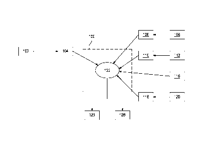
[0005] FIG. 1 is a flow diagram
of a method that uses a
mathematical model to correlate petrophysical properties, seismic attributes,
and microseismic data according to at least some embodiments of the present
disclosure.
[0006] FIG. 2 depicts a
schematic diagram of an exemplary wireline
system that may employ the principles of the present disclosure.
[0007] FIG. 3 depicts a
schematic diagram of an exemplary system
including a horizontal well that may employ the principles of the present
disclosure.
[0008] FIG. 4 is a cross-plot
of the microseismic magnitude values
and the fault likelihood values at the microseismic event location where the
relationship was established as a first-order linear regression with a
regression
line having a measured correlation coefficient (P, also referred to herein as
the
"correlation") is overlayed.
[0009] FIG. 5 is a correlation
grid for fault likelihood, petrophysical
properties, and microseismic data of the subterranean formation.
[0010] FIG. 6 is a correlation
grid for seismic derived fault likelihood,
seismic structural attributes and petrophysical properties of the subterranean
formation.
DETAILED DESCRIPTION
[0011] The present application
relates to methods and systems that
utilize multivariate analysis when modeling fracture networks of subterranean
formations. More specifically, the multivariate analysis involves correlating
seismic attributes (e.g., fault likelihood, curvature attributes, seismic
impedance,
and the like) for a subterranean formation with petrophysical properties of
the
subterranean formation and/or microseismic data associated with treating,
creating, and/or extending a fracture network of the subterranean formation.
These correlations may enhance the differentiation between natural and induced
fractures within a complex fracture network by identifying the origin of
microseismic events, which may improve the completion design and reservoir
modeling.
2
CA 03032777 2019-02-01
WO 2018/067119 PCMJS2016/055285
[0012] As used herein, the term
"seismic attribute" refers to a
chemical or physical property of the subterranean formation derived from
seismic data. Exemplary seismic attributes may include, but are not limited
to,
fault likelihood, curvature attributes, seismic impedance, and the like. As
used
herein, the term "fault likelihood" refers to a probability that a fault
exists at a
given location. In some instances, fault likelihood may be reported as a
likelihood volume computed using the fault oriented semblance algorithm
described by Hale (GEOPHYSICS, VOL. 78, NO. 2 (MARCH-APRIL 2013), P. 033-
043, Methods to compute fault images, extract fault surfaces, and estimate
fault
throws from 3D seismic images). In this example, the likelihood scale varies
from 0 (no fault) to 1 (high likelihood of locating a fault in the volume).
Other
scales may be used.
[0013] As used herein, the term
"petrophysical property" refers to a
chemical or physical property of a rock lithology of a subterranean formation
including any chemical or physical interactions between the rock and a fluid
contained therein. Exemplary petrophysical properties may include, but are not
limited to, sonic and shear impedances, minerology, porosity, permeability,
relative permeability, capillarity, saturation, brittleness, matrix density,
composition, stresses of the formation, and the like, and any combination
thereof. In some instances, the correlation between seismic attributes and a
petrophysical property may be direct where a distinct value for the
petrophysical
property is used in the correlation. Alternative to or in combination with
direct
correlation, the correlation between seismic attributes and a petrophysical
property may be indirect where measured data of the subterranean formation
that relates to the petrophysical property are used in the correlation. For
example, gamma ray measurements, nuclear magnetic resonance
measurements, and sonic measurements of a subterranean formation relate to
the porosity. In a direct correlation, one or more of the foregoing
measurements
may be used to calculate porosity that is then correlated to a seismic
attribute.
In an indirect correlation, one or more of the foregoing measurements may be
correlated to the fault likelihood. Unless otherwise specified, the terms
"correlate" and derivatives thereof when referring to a correlation between
seismic attributes and a petrophysical property encompasses direct
correlations,
indirect correlations, and a combination of direct and indirect correlations.
Further, unless otherwise specified, the terms "correlation between seismic
3
CA 03032777 2019-02-01
WO 2018/067119 PCT/1JS2016/055285
attributes and a petrophysical property" and derivatives thereof encompasses
correlation between seismic attributes and the petrophysical property,
correlation between that seismic attribute and the measured data of the
subterranean formation that relates to the petrophysical property, and any
combination thereof.
[0014] As used herein,
"measured data that relates to the
petrophysical property" refers to data directly measured by a sensor and/or
data
derived or otherwise calculated from data measured by a sensor, wherein,
whether directly measured or derived/calculated, the data relates to a
petrophysical property of the formation. The measured data that relates to the
petrophysical property may be from, for example, nuclear magnetic resonance
measurements, gamma ray measurements, photoelectric measurements,
neutron measurements, geochemical measurements, resistivity measurements,
acoustic measurements, borehole imaging measurements, mud logs, core
sample measurements, geomechanical measurements, and the like, and any
combination thereof, which may be collected with surface tools, measurement-
while-drilling (MWD) tools, logging-while-drilling (LWD) tools, wireline
tools, or
combinations thereof. More specifically, examples of measured data may
include, but are not limited to, p-wave acoustic impedance (which relates to
in-
situ stresses of the formation), s-wave shear impedance (which relates to in-
situ
stresses of the formation), slowness in the formation (derived from a sonic
measurements, which relates to porosity), gamma rays (which relates to
minerology), positive or negative sonic curvature (which relates to structural
changes that relate to potential fracturing), photoelectric factor (which
relates to
rock matrix properties and density), Young's modulus and Poisson's ratio
(which
relate to the elastic properties of the formation and derived using sonic
velocity,
shear velocity and density; it also relates to the formation stress), and the
like,
and any combination thereof.
[0015] Hydraulic fracturing
treatments (also referred to herein as
"fracturing treatments") are typically conducted to create fractures in the
subterranean formation, and to thereby enhance hydrocarbon productivity of the
subterranean formation. The pressures generated by the fracturing treatment
can induce low-amplitude or low-energy seismic events in the subterranean
formation, known as microseismic events. Other treatments to a fracture
network may cause microseismic events that may be monitored to acquire
4
CA 03032777 2019-02-01
WO 2018/067119 PCMJS2016/055285
microseismic data for analysis. For example, stimulation operations like
injections and steam assisted gravity drainage treatments to a fracture
network
may cause microseismic events.
[0016] As used herein, the term
"microseismic event" refers to a
micro-earthquake that originates as a result of changing the stress
distribution
within a subterranean formation, for example, in response to hydraulic
fracturing
treatments or other treatments to the fracture network. Microseismic events
may originate from, for example, rock slips, rock movements, rock fractures,
or
other events in the subterranean formation.
[0017] The seismic waves
produced by microseismic events are
detected by sensors, and, then, the microseismic waveforms detected by the
sensors may be processed and analyzed to determine the size and location in
time and space of the microseismic events and various attributes associated
with
the microseismic data. Sensors may be placed in a plurality of locations
relative
to the wellbore in which the treatment is being conducted, for example, in a
well
(e.g., an observation well, an injection well, a treatment well, or a
production
well) that is sufficiently close to the fracture network to measure
microseismic
data, at the Earth's surface, buried at shallow depth (less than about 500 m),
and the like, and any combination thereof. Generally, the sensors measure
microseismic data from one or more of the foregoing locations prior to,
during,
and after the treatment.
[0018] Exemplary sensors used
to detect microseismic events may
include, but are not limited to, geophones, accelerometers, fiber optics
distributed acoustic sensors (DAS), and the like, and any combination thereof.
Generally, more than one sensor (e.g., two or more of a single type of sensor
or
a combination of two or more types of sensors) may be used in a sensor array.
[0019] Exemplary microseismic
data may include, but are not
limited to, magnitude of the microseismic events, relative time of
microseismic
events, location in space and time of the microseismic events, source
mechanism of microseismic events, p-wave to s-wave amplitude ratios, signal to
noise ratios, seismic moment, amount of shear associated with microseismic
events, microseismic moment tensors, confidence value of the microseismic
events, density of microseismic events, geometry of induced fractures
estimated
from microseismic events, and the like, and any combination thereof.
5
CA 03032777 2019-02-01
WO 2018/067119 PCT/1JS2016/055285
[0020] Microseismic data may be
collected in association with
treating, creating, and/or extending a fracture network. The microseismic data
may be acquired before the treatment begins, during the treatment, after the
treatment has terminated, or any combination thereof.
[0021] The systems and methods
of the present application
correlate seismic attributes for a subterranean formation with one or more
petrophysical properties of the subterranean formation and/or microseismic
data
associated with treating a complex fracture network in a subterranean
formation
for identifying natural and induced fractures within the complex fracture
network.
[0022] FIG. 1 is a flow diagram
of a method that uses a
mathematical model 100 to determine a correlation 122 between seismic
attributes 104 with petrophysical properties 106,110 of the subterranean
formation and/or microseismic data maps 118 associated with treating a
complex fracture network according to at least some embodiments of the
present disclosure.
[0023] More specifically, as
illustrated, measured data like well logs
108 and geochemical and core data 112 may be processed deterministically
(e.g., using a Kriging process) or stochastically (e.g., using conditional
simulations) to produce petrophysical property maps 106,110, respectively.
[0024] As used herein, the term
"map" refers to a given
characteristic and/or property represented as a 3-dimensional grid matrix of
the
subterranean formation (also known as a geocellular grid), a 2-dimensional
array representing the formation properties on a 2-dimensional plane, a 1-
dimensional array representing the subterranean formation, and the like. In a
1-
dimensional array, the data points of the formation (e.g., the data points in
the
geocellular grid) are converted to a mathematical matrix having matrix
identification values corresponding to each of the data points in the
geocellular
grid.
[0025] Petrophysical property
maps 106,110 may be of a specific
petrophysical property for direct correlations with the seismic attribute map
104
or of measurements/data related to the petrophysical property for indirect
correlations as described above.
[0026] Further, microseismic data 120 may be processed
deterministically or stochastically to produce microseismic data maps 118.
6
CA 03032777 2019-02-01
WO 2018/067119 PCMJS2016/055285
[0027] In some instances,
additional mathematical analyses and
manipulations may be performed, prior to or during the modelling, which may
include, but are not limited to, normalizing data gathered (e.g., the well log
data
108, the geochemical and core data 112, the seismic data 102, and the
microseismic data 120), calibrating the mathematical mode 100 to any remotely
sensed data (e.g., the well log data 108, the geochemical and core data 112,
the
seismic data 102, and the microseismic data 120), and the like, and any
combination thereof.
[0028] The measured data (e.g.,
well log data 108 and the
geochemical and core data 112) may be from one or more measurements of the
subterranean formation, for example, nuclear magnetic resonance
measurements, gamma ray measurements, photoelectric measurements,
neutron measurements, geochemical measurements, resistivity measurements,
acoustic measurements, borehole imaging measurements, mud logs,
geomechanical measurements, and the like, and any combination thereof, which
may be collected with MWD tools, LWD tools, wireline tools, or combinations
thereof. In some instances, the measured data 108,112,116 may be collected in
association with treating a complex fracture network.
[0029] The petrophysical
property maps 106,110 and microseismic
data maps 118 may be a model of one or more properties or characterizations of
the subterranean formation that relate to the fractures therein including
those
described herein related to the seismic attribute map 104.
[0030] Further, the completion
and treatment data 116 (e.g., pump
rates, flow rates, wellbore pressures, and the like) may be collected.
[0031] The mathematical model
100 may then apply a multivariate
analysis of the seismic attribute map 104, the petrophysical property maps
106,110, the completion and treatment data 116, and the microseismic data
maps 118 to quantify the correlation 122 between the seismic attribute map 104
and each of the petrophysical property maps 106,110, the completion and
treatment data 116, and the microseismic data maps 118. The multivariate
analysis may involve simple linear or nonlinear regression to determine the
correlation coefficient, the coefficient of determination, or any other
goodness-
of-fit statistical method.
[0032] In instances, the
correlation (P) scale may vary from 0 (no
correlation) to 1 (high correlation). Other scales may be used. In instances
7
CA 03032777 2019-02-01
WO 2018/067119 PCMJS2016/055285
where the correlation 122 is poor (e.g., P<0.5), the seismic data 102, the
measured data 108,112, the completion and treatment data 116, and the
microseismic data 120 may be reviewed to determine if potentially false data
is
present and remove the false data.
[0033] In instances where the
correlation 122 is good (e.g., P>0.7
or P2>0.5), the petrophysical property maps 106,110, the completion and
treatment data 116, and the microseismic data maps 118 having the good
correlation 122 to the seismic attribute map 104 may be used as the basis for
further analysis and/or modelling of the subterranean formation (e.g.,
variogram
modelling 126 and reservoir modeling 128).
[0034] For example, with variogram modelling 126, the
petrophysical property maps 106,110, the completion and treatment data 116,
and the microseismic data maps 118 having the good correlation 122 to the
seismic attribute map 104 may be used as the basis for identifying natural and
induced fractures within the complex fracture network. By way of nonlimiting
example, overlaying the microseismic data maps 118 on the seismic attribute
map 104 may identify microseismic events occurring along likely faults as
reactivation of natural fractures and identify other microseismic events as
being
along induced fractures. Further, comparison with the petrophysical properties
such as brittleness may be further used to identify induced fractures along
brittle
portions of the formation.
[0035] In another example, with
reservoir modeling 128, the
petrophysical property maps 106,110, the completion and treatment data 116,
and the microseismic data maps 118 having the good correlation 122 to the
seismic attribute map 104 may be used as the basis for determine a location
for
drilling a new well into the subterranean formation that intersects the
complex
fracture network. For example, the location for drilling a new well may be
selected to intersect a highly connected portion of the complex fracture
network.
[0036] Also, the methods
described herein may be used to assess
the effectiveness of the treatment. Then, the completion and treatment data
116
having the good correlation 122 to the seismic attribute map 104 may be used
for future completions and treatment design of nearby wells.
[0037] Further, the
petrophysical property maps 106,110, the
completion and treatment data 116, and the microseismic data maps 118 having
the good correlation 122 to the seismic attribute map 104 may be used to (1)
8
CA 03032777 2019-02-01
WO 2018/067119 PCMJS2016/055285
improve reservoir production modelling or forecasting, (2) improve fracture
modeling (e.g., to model the degree and positon of fracture clustering), and
(3)
inform in-fill drilling decisions in a portion of the subterranean formation
of
interest.
[0038] The analyses and methods
described herein may be
implemented by a set of instructions that cause a processor to perform the
mathematical model 100. In some instances, the processor and set of
instructions may also be used for subsequent analyses of the petrophysical
property maps 106,110, the completion and treatment data 116, and the
microseismic data maps 118 having the good correlation 122 to the seismic
attribute map 104.
[0039] The processor may be a
portion of computer hardware used
to implement the various illustrative blocks, modules, elements, components,
methods, and algorithms described herein. The processor may be configured to
execute one or more sequences of instructions, programming stances, or code
stored on a non-transitory, computer-readable medium. The processor can be,
for example, a general purpose microprocessor, a microcontroller, a digital
signal
processor, an application specific integrated circuit, a field programmable
gate
array, a programmable logic device, a controller, a state machine, a gated
logic,
discrete hardware components, an artificial neural network, or any like
suitable
entity that can perform calculations or other manipulations of data. In some
embodiments, computer hardware can further include elements such as, for
example, a memory (e.g., random access memory (RAM), flash memory, read
only memory (ROM), programmable read only memory (PROM), erasable
programmable read only memory (EPROM)), registers, hard disks, removable
disks, CD-RUMS, DVDs, or any other like suitable storage device or medium.
[0040] Executable sequences
described herein can be implemented
with one or more sequences of code contained in a memory. In some
embodiments, such code can be read into the memory from another machine-
readable medium. Execution of the sequences of instructions contained in the
memory can cause a processor to perform the process steps described herein.
One or more processors in a multi-processing arrangement can also be
employed to execute instruction sequences in the memory. In addition, hard-
wired circuitry can be used in place of or in combination with software
instructions to implement various embodiments described herein. Thus, the
9
CA 03032777 2019-02-01
WO 2018/067119 PCT/1JS2016/055285
present embodiments are not limited to any specific combination of hardware
and/or software.
[0041] As used herein, a
machine-readable medium will refer to any
medium that directly or indirectly provides instructions to the processor for
execution. A machine-readable medium can take on many forms including, for
example, non-volatile media, volatile media, and transmission media. Non-
volatile media can include, for example, optical and magnetic disks. Volatile
media can include, for example, dynamic memory. Transmission media can
include, for example, coaxial cables, wire, fiber optics, and wires that form
a
bus. Common forms of machine-readable media can include, for example, floppy
disks, flexible disks, hard disks, magnetic tapes, other like magnetic media,
CD-
ROMs, DVDs, other like optical media, punch cards, paper tapes and like
physical
media with patterned holes, RAM, ROM, PROM, EPROM and flash EPROM.
[0042] FIG. 2 depicts a
schematic diagram of an exemplary wireline
system 200 that may employ the principles of the present disclosure, according
to one or more embodiments. At various times before, during, or after one or
more treatments of the complex fracture network, seismic data 102, measured
data 108,112, and microseismic data 120 of FIG. 1 may be collected for a
subterranean formation 210. In some instances, the wellbore tools extending
into a wellbore 204 (e.g., a work string for perforating the formation 210)
may
be removed from a wellbore 204 to conduct measurement/logging operations.
As illustrated, the wireline system 200 may include a one or more wireline
tools
202 that may be suspended into the wellbore 204 by a cable 212. The wireline
tools 202 may be communicably coupled to the cable 212. The cable 212 may
include conductors for transporting power to the wireline tools 202 and also
facilitate communication between the surface and the wireline tools 202. A
logging facility 206, shown in FIG. 2 as a truck, may collect measurements
from
the wireline tools 202, and may include computing facilities 208 for
controlling,
processing, storing, and/or visualizing the measurements gathered by the
wireline tools 202. The computing facilities 208 may be communicably coupled
to the wireline tools 202 by way of the cable 212. In some instances, the
mathematical model 100 of FIG. 1 may be implemented using the computing
facilities 208. Alternatively, the measurements gathered by the wireline tools
202 may be transmitted (wired or wirelessly) or physically delivered to
CA 03032777 2019-02-01
WO 2018/067119 PCMJS2016/055285
computing facilities off-site where the mathematical model 100 of FIG. 1 may
be
implemented.
[0043] FIG. 3 depicts a
schematic diagram of an exemplary system
300 that may employ the principles of the present disclosure, according to one
or more embodiments. In the illustrated system 300, a wellbore 302 with a
vertical section 304 and a horizontal section 306 is lined with the casing 308
cemented therein to support the wellbore 302. Alternatively, a portion of the
wellbore 302 may not have a casing, which is referred to as "open hole." For
example, the casing 308 may extend from a surface location, such as the
Earth's
surface, or from an intermediate point between the surface location and the
formation 310. In the illustrated system 300, a fiber optic cable 312 extends
along the casing 308.
[0044] One or more wellbore
tools 320, for example, a completion
assembly or perforating gun, may be used to prepare the horizontal section 306
for the subsequent extraction of hydrocarbons from the surrounding formation
310. For example, a completion assembly may include a plurality of packers
that
isolate the various production intervals in the horizontal section 306. In
some
instances, a fluid (e.g., a stimulation fluid, a treatment fluid, an acidizing
fluid, a
conformance fluid, or any combination thereof) may be injected into the
wellbore
302 or surrounding formation 310 via the wellbore tools 320.
[0045] The system 300 also
includes an observation well 322 that
has a plurality of geophones 324 placed therein for measuring seismic and/or
microseismic data. Further, the system 300 includes a plurality of surface
geophones 326 for measuring seismic and/or microseismic data.
[0046] Embodiments of the
present application include, but are not
limited to, Embodiment A, Embodiment B, and Embodiment C.
[0047] Embodiment A is a method
comprising: modeling one
selected from the group consisting of petrophysical properties of a
subterranean
formation, microseismic data associated with treating a complex fracture
network in the subterranean formation, and a combination thereof with the
mathematical model based on one selected from the group consisting of
measured data, microseismic data, completion and treatment data, and a
combination thereof to produce one selected from the group consisting of a
petrophysical property map, a microseismic data map, and a combination
thereof; and correlating a seismic attribute map with one selected from the
11
CA 03032777 2019-02-01
WO 2018/067119 PCMJS2016/055285
group consisting of the petrophysical property map, the microseismic data map,
and the combination thereof using the mathematical model to produce at least
one quantified correlation, wherein the seismic attribute map is a seismic
attributed modeled for the complex fracture network.
[0048] Embodiment B is a system
comprising: a wellbore tool placed
along a wellbore extending into a subterranean formation; a non-transitory
computer-readable medium coupled to the wellbore tool to receive measured
data of the subterranean formation from the wellbore tool and encoded with
instructions that, when executed, cause the system to perform the method of
Embodiment A.
[0049] Embodiment C is a non-
transitory computer-readable
medium encoded with instructions that, when executed, cause a system to
perform the method of Embodiment A.
[0050] Optionally Embodiments
A, B, and C may include one or
more of the following: Element 1: the method further comprising: modeling the
seismic attribute for the complex fracture network within the subterranean
formation with the mathematical model based on seismic data of the
subterranean formation to produce the seismic attribute map; Element 2: the
method further comprising: determining a location to drill a wellbore into the
subterranean formation so as to intersect the complex fracture network based
on the at least one quantified correlation; Element 3: the method further
comprising: identifying natural fractures and induced fractures within the
complex fracture network; Element 4: wherein the measured data of the
subterranean formation is selected from the group consisting of: seismic data,
gravimetric data, magnetic data, magnetotelluric data, and any combination
thereof; Element 5: the method further comprising: updating a reservoir
production model based on the at least one quantified correlation; Element 6:
the method further comprising: updating a fracture model based on the at least
one quantified correlation; Element 7: the method further comprising:
performing a wellbore treatment operation with at least one parameter based on
the at least one quantified correlation; and Element 8: drilling or extending
a
wellbore so that the wellbore intersects the complex fracture network based on
the at least one quantified correlation.
[0051] Exemplary combinations
may include, but are not limited to,
Element 1 in combination with one or more of Elements 2-8; Element 7 and/or 8
12
CA 03032777 2019-02-01
WO 2018/067119 PCT/1JS2016/055285
in combination with one or more of Elements 1-6; Element 3 in combination with
Element 2; Element 3 in combination with one or more of Elements 4-8 and
optionally in further combination with Element 2; and the like.
[0052] Unless otherwise
indicated, all numbers expressing quantities
of ingredients, properties such as molecular weight, reaction conditions, and
so
forth used in the present specification and associated claims are to be
understood as being modified in all instances by the term "about."
Accordingly,
unless indicated to the contrary, the numerical parameters set forth in the
following specification and attached claims are approximations that may vary
depending upon the desired properties sought to be obtained by the
embodiments of the present invention. At the very least, and not as an attempt
to limit the application of the doctrine of equivalents to the scope of the
claim,
each numerical parameter should at least be construed in light of the number
of
reported significant digits and by applying ordinary rounding techniques.
[0053] One or more illustrative
embodiments incorporating the
invention embodiments disclosed herein are presented herein. Not all features
of
a physical implementation are described or shown in this application for the
sake
of clarity. It is understood that in the development of a physical embodiment
incorporating the embodiments of the present invention, numerous
implementation-specific decisions must be made to achieve the developer's
goals, such as compliance with system-related, business-related, government-
related and other constraints, which vary by implementation and from time to
time. While a developer's efforts might be time-consuming, such efforts would
be, nevertheless, a routine undertaking for those of ordinary skill in the art
and
having benefit of this disclosure.
[0054] While compositions and
methods are described herein in
terms of "comprising" various components or steps, the compositions and
methods can also "consist essentially of" or "consist of" the various
components
and steps.
[0055] To facilitate a better
understanding of the embodiments of
the present invention, the following examples of preferred or representative
embodiments are given. In no way should the following examples be read to
limit, or to define, the scope of the invention.
13
CA 03032777 2019-02-01
WO 2018/067119 PCT/1JS2016/055285
EXAMPLES
[0056] The measured data that
was used included well log data,
seismic data (negative sonic curvature and positive sonic curvature), and
microseismic data (magnitude of microseismic events) for a subterranean
formation. Using the seismic data, a fault likelihood volume was created. A
mathematical model produced a fault likelihood 3D grid of the formation. The
following describes in more detail some of the data analyses and correlations
performed by the mathematical model.
[0057] The mathematical model
produced a 3D grid of each of the
measured data types and then quantified the correlation each property on the
3D grid to the fault likelihood map using a cross-plot. FIG. 4 is a cross-plot
of
the microseismic magnitude map and the fault likelihood values on the 3D grid
where the first-order correlation line is overlayed, which quantifies the
correlation as 0.27. FIG. 5 provides the correlations between the various
maps:
fault likelihood: microseismic magnitude 0.270, fault likelihood: negative
curvature 0.371, and fault likelihood:positive curvature: 0.450. Accordingly,
the
microseismic data and/or associated maps may be reviewed to identify and
delete false data points.
[0058] In another example, data
was measured for a subterranean
formation including well log data and measured data (p-wave acoustic
impedance, s-wave shear impedance, sonic log (slowness of a sound wave in a
formation), gamma ray log, negative curvatures, positive curvatures, and
photoelectric factor). Similarly, the fault likelihood 3D grid was produced
from
the seismic data and correlated to 3d grids corresponding to each of the
measured data. Further, the brittleness and simulated brittleness
(petrophysical
properties) were modeled and mapped on the 3D grid. FIG. 6 provides the
correlations between the various grids: fault likelihood:p-wave acoustic
impedance 0.911, fault likelihood:s-wave shear impedance -0.565, fault
likelihood: brittleness 0.326, fault likelihood :simulated brittleness 0.474,
fault
likelihood:sonic log -0.376, fault likelihood:gamma ray log -0.455, fault
likelihood: negative curvatures 0.282, fault likelihood: positive curvatures
0.679,
and fault likelihood:photoelectric factor 0.465. In this example, fault
likelihood
correlates best with p-wave acoustic impedance, s-wave shear impedance and
positive sonic curvatures, and there is also a considerable correlation
between
fault likelihood and brittleness of the formation.
14
[0059] Therefore, the present invention is well adapted to attain the ends
and advantages mentioned as well as those that are inherent therein. The
particular
embodiments disclosed above are illustrative only, as the present invention
may be
modified and practiced in different but equivalent manners apparent to those
skilled
in the art having the benefit of the teachings herein. Furthermore, no
limitations
are intended to the details of construction or design herein shown. It is
therefore
evident that the particular illustrative embodiments disclosed above may be
altered,
combined, or modified and all such variations are considered within the scope
and
spirit of the present invention. The invention illustratively disclosed herein
suitably
may be practiced in the absence of any element that is not specifically
disclosed
herein and/or any optional element disclosed herein. While compositions and
methods are described in terms of "comprising," "containing," or "including"
various
components or steps, the compositions and methods can also "consist
essentially
of" or "consist of" the various components and steps. All numbers and ranges
disclosed above may vary by some amount. Whenever a numerical range with a
lower limit and an upper limit is disclosed, any number and any included range
falling within the range is specifically disclosed. In particular, every range
of values
(of the form, "from about a to about b," or, equivalently, "from approximately
a to
b," or, equivalently, "from approximately a-b") disclosed herein is to be
understood
to set forth every number and range encompassed within the broader range of
values. Also, the terms herein have their plain, ordinary meaning unless
otherwise
explicitly and clearly defined by the patentee. Moreover, the indefinite
articles "a"
or "an" are defined herein to mean one or more than one of the element that it
introduces.
Date recu/Date Received 2020-04-14