Note: Descriptions are shown in the official language in which they were submitted.
CA 03038814 2019-03-29
WO 2018/064716 PCT/AU2017/051075
1
A GRAVIMETER ASSEMBLY
TECHNICAL FIELD
[0001] This invention relates to a gravimeter assembly,
an aircraft configured for gravimetry, and a gravimetry
method.
BACKGROUND ART
[0002] The following discussion of the background art is
intended to facilitate an understanding of the present
invention only. The discussion is not an acknowledgement or
admission that any of the material referred to is or was
part of the common general knowledge as at the priority date
of the application.
[0003] Gravimetry is generally the measurement of the
strength of a gravitational field. Gravimetry may be used
when either the magnitude of a gravitational field or the
properties of matter responsible for the creation of such a
field are of interest.
[0004] The most common conventional airborne method for
measuring a scalar gravity field over a surface of the earth
is from an aircraft fitted with a 3-axis stabilised
gravimeter mounted on a floor of the aircraft. Such a
gravimeter typically has a main sensor (an accelerometer)
mounted vertically on a 3-axis gyro-stabilised platform.
[0005] The gyro-stabilised platform isolates the main
sensor from the rotations of the aircraft and the input axis
CA 03038814 2019-029
WO 2018/064716 PCT/AU2017/051075
2
of the sensor is kept vertical in the relevant inertial
frame of reference to minimise contamination of the signal
with horizontal accelerations. The main sensor measures the
total vertical accelerations to which it is subjected, being
a combination of the vertical accelerations due to inertial,
or kinematic, motion, as well as the accelerations due to
gravity.
[0006] A second airborne method involves the use of so-
called Strapdown Inertial Navigation System (SINS) fixed to
the body of an aircraft. A SINS generally contains two
sensor triads. The first is an orthogonal set of
accelerometers that measure specific force and the second is
an orthogonal set of gyroscopes that measure angular
velocity. These triads are strapped to the body of the host
vehicle, such as an aircraft, and therefore go through the
full range of motion experienced by the aircraft. If the
SINS contains a triad of accelerometers and a triad of
gyroscopes, then the three vector components of the
accelerations (including the vertical component) can be
determined after correction for aircraft attitude.
[0007] One basic difficulty with gravimetry from a moving
aircraft is the fact that on grounds of the principle of
equivalence, an accelerometer indicates the sum of
gravitational acceleration and kinematic acceleration. If a
measurement of only the gravitational acceleration is
desired, it is necessary to eliminate the kinematic
acceleration resulting from the motion of the aircraft. As
such, the principle of equivalence dictates that without
this additional information, it is not possible to separate
CA 03038814 2019-029
WO 2018/064716 PCT/AU2017/051075
3
the desired parameter, being the vertical acceleration due
to gravity, from the total accelerations measured.
[0008] For this reason, some manner of global navigation
satellite system (GNSS) is used. A satellite navigation
receiver, most commonly a Global Positioning System (GPS)
receiver, is connected to an antenna mounted on the aircraft
fuselage above the gravimeter. The conventional methods use
GPS to measure the vertical inertial accelerations. The
inertial accelerations from the GPS can then be subtracted
from the total accelerations measured by the gravimeter to
give the vertical acceleration due to gravity.
[0009] However, the conventional methods have several
drawbacks. For instance, the requirement to use GPS provides
a limit on the resolution of the resulting data, as long-
wavelength filters (commonly in the range of 60 to 100
seconds) are required in order to produce measurements of
the vertical accelerations to the required level of
accuracy. As an aircraft generally moves a considerable
distance in this time, the resolution of the resulting data
is therefore measured in kilometres rather than metres.
[0010] Additionally, results from GPS are more accurate
if the data is differentially processed. That is, if the
data from the GPS on the aircraft is processed in tandem
with data from a static GPS receiver, i.e. a base station,
after completion of the data acquisition flight. Although
real-time differential GPS data services are available
commercially, these result in less accurate gravity data
compared to differentially post-processed data. This means
CA 03038814 2019-03-29
WO 2018/064716 PCT/AU2017/051075
4
it is impossible to produce high quality gravity data in
close to real time.
[0011] Finally, differentially processed GPS data
requires common satellites between the aircraft-mounted GPS
receiver and the base station GPS receiver in order to
provide the most accurate results. Ideally, the same GPS
satellites should be visible to both the aircraft-mounted
GPS receiver and the base station. However, this can vary
widely depending on the latitude of operation and the
available GPS constellation at any given time of day, which
can limit the effective range of a gravimeter mounted in an
aircraft.
[0012] The present invention seeks to propose possible
solutions, at least in part, in amelioration of some of the
known shortcomings in the art.
SUMMARY OF THE INVENTION
[0013] It is to be appreciated by the skilled addressee
that reference herein to a gravimeter generally includes
reference to a 3-axis stabilised and/or a SINS gravimeter,
except if a particular restriction, limitation and/or
configuration excludes the use of such a gravimeter.
[0014] According to a first aspect of the invention there
is provided a gravimeter assembly comprising:
a gravimeter;
at least one global navigation satellite system (GNSS)
receiver arranged in signal communication with the
gravimeter; and
CA 03038814 2019-029
WO 2018/064716 PCT/AU2017/051075
a Doppler lidar system arranged in signal communication
with the gravimeter, the lidar system configured to
determine a vertical velocity of the assembly at a
predetermined time, a time signal from the GNSS receiver
operatively synchronising both gravimeter and lidar
measurements, so that a gravitational acceleration
measurement of the gravimeter is differentially isolable
from a kinematic acceleration derivable from the synchronous
lidar measurement.
[0015] Typically, the gravimeter comprises a three-axis
stabilised platform with an accelerometer having a
vertically arranged input axis to prevent signal
contamination from horizontal accelerations.
[0016] Typically, the Doppler lidar system is coaxially
arranged on the input axis.
[0017] Typically, the GNSS receiver and/or a suitable
antenna thereof is coaxially arranged on the input axis. It
is to be appreciated that such a GNSS receiver, either alone
or in combination with any suitable antenna arrangement is
hereinafter collectively referred to as 'GNSS receiver'.
[0018] Typically, the Doppler lidar system includes a
laser generator that produces a single frequency laser beam,
and a frequency modulator arranged in signal communication
with the laser generator.
[0019] Typically, the frequency modulator receives the
laser beam from the laser generator, and linearly modulates
CA 03038814 2019-03-29
WO 2018/064716 PCT/AU2017/051075
6
the frequency of the laser beam to produce a triangular
waveform with a high degree of linearity.
[0020] Typically,
the Doppler lidar system includes an
amplifier arranged in signal communication with the
frequency modulator, said amplifier configured to receive
and amplify a first portion of the modulated laser beam.
[0021] Typically,
the Doppler lidar system includes at
least one photo transceiver arranged in communication with
the amplifier, said photo transceiver configured to transmit
a part of the first portion of the amplified laser beam from
the amplifier, and to subsequently receive reflected
radiation from such transmitted laser beam.
[0022] Typically,
the Doppler lidar system includes at
least three photo transceivers.
[0023] Typically,
each photo transceiver is configured to
mix the received reflected radiation with a part of a second
portion of the modulated laser beam for optical heterodyne
detection.
[0024] Typically,
each of the at least three photo
transceivers are aimed to transmit the laser beam in a
different direction, and are stationary relative to each
other.
[0025] Typically,
the received reflected radiation from
each part of the transmitted first portion of the laser beam
is compared with a second portion of the modulated laser
beam to determine a frequency difference between the
CA 03038814 2019-03-29
WO 2018/064716 PCT/AU2017/051075
7
frequency of the received reflected radiation and the
frequency of the modulated laser beam to determine the
vertical velocity of the assembly.
[0026] Typically, the GNSS receiver is configured to
operatively measure a vertical kinematic acceleration of the
assembly.
[0027] Typically, the assembly includes a second GNSS
receiver operatively located distal from the assembly to
allow differential processing of vertical kinematic
acceleration measurements from the first GNSS receiver.
[0028] In one example, the GNSS receiver and Doppler
lidar system are mounted on the gravimeter.
[0029] Typically, the GNSS receiver and Doppler lidar
system are mounted on the three-axis stabilised platform.
[0030] Typically, the assembly is installed in an
aircraft.
[0031] Typically, the assembly is installed in an
aircraft such that the GNSS receiver has a clear view of the
sky at a top of the aircraft, with the Doppler lidar system
having a clear view of the ground below the aircraft.
[0032] In one example, the assembly is installed in an
unmanned aerial vehicle (UAV).
CA 03038814 2019-029
WO 2018/064716 PCT/AU2017/051075
8
[0033] According to a second aspect of the invention
there is provided an aircraft configured for gravimetry,
said aircraft comprising:
a gravimeter;
at least one global navigation satellite system (GNSS)
receiver arranged in signal communication with the
gravimeter; and
a Doppler lidar system arranged in signal communication
with the gravimeter, the lidar system configured to
determine a vertical velocity of the aircraft and/or
gravimeter at a predetermined time;
wherein a time signal from a GNSS receiver operatively
synchronises both gravimeter and lidar measurements, so that
a gravitational acceleration measurement of the gravimeter
is differentially isolable from a kinematic acceleration
derivable from the synchronous lidar measurement.
[0034] Typically, the gravimeter comprises a three-axis
stabilised platform with an accelerometer having a
vertically arranged input axis to prevent signal
contamination from horizontal accelerations.
[0035] Typically, the Doppler lidar system is coaxially
arranged on the input axis.
[0036] Typically, the GNSS receiver is coaxially arranged
on the input axis.
[0037] Typically, the Doppler lidar system includes a
laser generator that produces a single frequency laser beam,
and a frequency modulator arranged in signal communication
with the laser generator.
CA 03038814 2019-03-29
WO 2018/064716 PCT/AU2017/051075
9
[0038] Typically, the frequency modulator receives the
laser beam from the laser generator, and linearly modulates
the frequency of the laser beam to produce a triangular
waveform with a high degree of linearity.
[0039] Typically, the Doppler lidar system includes an
amplifier arranged in signal communication with the
frequency modulator, said amplifier configured to receive
and amplify a first portion of the modulated laser beam.
[0040] Typically, the Doppler lidar system includes at
least one photo transceiver arranged in communication with
the amplifier, said photo transceiver configured to transmit
a part of the first portion of the amplified laser beam from
the amplifier, and to subsequently receive reflected
radiation from such transmitted laser beam.
[0041] Typically, the Doppler lidar system includes at
least three photo transceivers.
[0042] Typically, each photo transceiver is configured to
mix the received reflected radiation with a part of a second
portion of the modulated laser beam for optical heterodyne
detection.
[0043] Typically, each of the at least three photo
transceivers are aimed to transmit the laser beam in a
different direction, and are stationary relative to each
other.
CA 03038814 2019-03-29
WO 2018/064716 PCT/AU2017/051075
[0044] Typically, the received reflected radiation from
each part of the transmitted first portion of the laser beam
is compared with a second portion of the modulated laser
beam to determine a frequency difference between the
frequency of the received reflected radiation and the
frequency of the modulated laser beam to determine the
vertical velocity of the aircraft.
[0045] Typically, the GNSS receiver is configured to
operatively measure a vertical kinematic acceleration of the
aircraft.
[0046] In one example, the GNSS receiver and/or Doppler
lidar system are mounted on the gravimeter.
[0047] Typically, the GNSS receiver and/or Doppler lidar
system are mounted on the three-axis stabilised platform.
[0048] According to a third aspect of the invention there
is provided a gravimetry method comprising the steps of:
mounting a gravimeter assembly, in accordance with the
first aspect of the invention, in an aircraft;
flying a gravimetry survey with the aircraft; and
synchronising both the gravimeter and lidar
measurements during said survey with a time signal from the
GNSS receiver, so that a gravitational acceleration
measurement of the gravimeter is differentially isolable
from a kinematic acceleration derivable from the synchronous
lidar measurement.
CA 03038814 2019-03-29
WO 2018/064716 PCT/AU2017/051075
11
BRIEF DESCRIPTION OF THE DRAWINGS
The description will be made with reference to the
accompanying drawings in which:
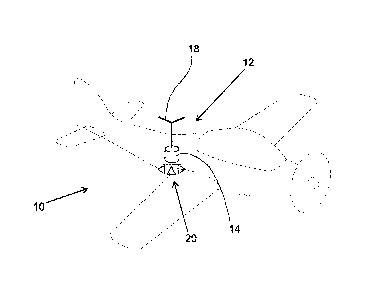
Figure 1 is a diagrammatic perspective-view
representation of an aircraft with one example of a
gravimetry assembly, in accordance with an aspect of the
invention;
Figure 2 is a diagrammatic representation of signal
communication between components of one example of the
gravimetry assembly of Figure 1;
Figure 3 is a diagrammatic representation of loosely
integrated components comprising one example of the
gravimetry assembly of Figure 1; and
Figure 4 is a diagrammatic representation of tightly
integrated components comprising one example of the
gravimetry assembly of Figure 1.
DETAILED DESCRIPTION OF EMBODIMENTS
[0049] Further features of the present invention are more
fully described in the following description of several non-
limiting embodiments thereof. This description is included
solely for the purposes of exemplifying the present
invention to the skilled addressee. It should not be
understood as a restriction on the broad summary, disclosure
or description of the invention as set out above. In the
figures, incorporated to illustrate features of the example
CA 03038814 2019-029
WO 2018/064716 PCT/AU2017/051075
12
embodiment or embodiments, like reference numerals are used
to identify like parts throughout.
[0050] With
reference now to Figure 1 of the accompanying
drawings, there is shown an aircraft 10 which has been
configured for conducting airborne gravimetry surveys. In
this example, the aircraft 10 comprises a gravimeter 14, a
global navigation satellite system (GNSS) receiver
18
arranged in signal communication with the gravimeter 14, as
well as a Doppler lidar system 20 arranged in signal
communication with the gravimeter 14.
[0051] The lidar
system 20 is configured to determine a
vertical velocity of the aircraft 10 at a predetermined
time, with a time signal from the GNSS receiver 18 used to
operatively synchronise both the gravimeter 14 and lidar
system 20 measurements. In this manner, a gravitational
acceleration measurement of the gravimeter 14 is
differentially isolable from a kinematic acceleration
derivable from the synchronous lidar measurement.
[0052] In this
manner and according to the principle of
equivalence, the skilled addressee will appreciate that it
is possible to eliminate the kinematic acceleration
resulting from the motion of the aircraft 10, making it
possible to separate the vertical acceleration due to
gravity from the total accelerations measured.
[0053] It is to
be appreciated that lidar, (Light Imaging
Detection and Ranging) generally uses ultraviolet, visible,
or near infrared light to image objects with very high
resolutions. Such high resolution can be achieved due to the
WO 2018/064716
PCT/AU2017/051075
13
wavelength of signals in the light spectrum, e.g. wavelengths
between 100nm and 100pm. Otherwise, using technologies such as
radar (Radio Detection and Ranging) , which uses signals in the
radio frequency spectrum having wavelengths of lmm to 100km, does
generally not provide sufficient resolution to facilitate
differential isolation between a gravitational acceleration
measurement and a kinematic acceleration, as is required by the
present invention.
[0054]
By way of background, a general description of an example
of components comprising one particular type of gravimeter 14 is
now provided with reference to Figure 2, showing typical components
comprising the gravimeter and signal flow between these various
components or sub-systems. However, it will be appreciated by the
skilled addressee that various other types or configurations of
the gravimeter are possible and within the scope of this invention.
[0055] As such, the exemplified embodiment of gravimeter 14
typically includes a vertical accelerometer, or gravity sensing
element (GSE) 32, having a suspension design to minimise effects
of cross-coupling, an undesirable effect which contaminates
gravity measurements with components of horizontal accelerations
induced by aircraft motion. The vertically oriented GSE 32 is
installed on a three-axis gyro stabilised platform 16 with a
Schuler-tuned integral correction circuit. The correction circuit
uses external information on latitude and vehicle velocity from
the GNSS, typically a Global Positioning System (GPS), receiver 18
to dampen the platform 16 during aircraft motion.
[0056] [intentionally blank]
CA 3038814 2021-05-04
WO 2018/064716
PCT/AU2017/051075
14
[0057] The gyro stabilized platform 16 is generally located in a
three-axis gimbal suspension, which includes a dynamically tuned
gyro (DTG) 38, two horizontal accelerometers ACx and ACy 34, and
a fiber-optic gyro (FOG) 36 with a vertical sensitive axis. Output
signals Wx and Wy from accelerometers 34, output signal Wz from
the GSE 32, output signals B and y from DTG angle sensors of DTG
38, and the FOG 36 output S-2, go to the central processor unit
(CPU) 48 via the analog-to-digital converter (ADC) 44.
[0058] ASx, ASy, ASz angle stabilization sensors 30 are installed
on the gimbal suspension axes and on the vertical axis of the
platform 16 to measure pitch and roll angles and the heading. DTG
control signals Qx and Qy, generated in the CPU 48, go to the DTG
torque sensors of DTG 38 via the digital-to-analogue converter
(DAC) 46. Servo system control signals Mx, My and Mz generated in
the CPU 48 typically go to the servo system torque motors TMx and
TMy 42 via the DAC 46 and a power amplifier.
[0059] Current proportional to the vertical apparent acceleration
Wz runs in the measurement coil of the GSE force sensor and in a
reference resistor serially connected to a coil. An output signal
Wz, in the form of the voltage read from the reference resistor
goes to the CPU 48 via the ADC 44. A reference current, which
balances a fixed value of the gravitational force, is applied to
a second winding of the GSE force sensor.
[0060] The integrated microprocessor or CPU 48 controls the servo
system, which stabilizes the platform 16, maintains a temperature
control circuit (TCS) 40, and
CA 3038814 2021-05-04
CA 03038814 2019-03-29
WO 2018/064716 PCT/AU2017/051075
provides GSE output signal processing. The Temperature
Control System (ICS) 40 generally provides constant
temperature for all sensing elements. As mentioned above,
the pulse-per-second plus time (PPS+TIME) from the satellite
navigation receiver 18 is input to both the gravimeter 14
and the Doppler lidar system 20 to synchronise the
measurement of velocities and accelerations by each of these
sub-systems.
[0061] Gravimeter control commands, data communication,
gravimetric and navigation data display, and preliminary
processing and recording on hard disk for post-processing
are provided via the external control and display unit (CDU)
50. A general purpose computer, such as a personal computer
(PC) 52 is generally used for such post-processing.
[0062] As mentioned above, other forms and/or
configurations of gravimeters are possible and within the
scope of this disclosure. Similarly, depending on a specific
configuration of gravimeter, communication between the
various components may be different from the exemplified
embodiment, as will be understood by the skilled addressee.
[0063] With reference now to Figures 3 and 4 of the
drawings, there are shown two different modes of the
assembly 12. Figure 3 shows a so-called "loose integration"
between the lidar system 20 and the GSE 32 of the gravimeter
14. Similarly, Figure 4 shows a "tight integration" between
the lidar system 20 and the GSE 32 of the gravimeter 14.
[0064] Importantly, as mentioned above, the GSE
accelerometer 32 has a vertically arranged input axis
CA 03038814 2019-029
WO 2018/064716 PCT/AU2017/051075
16
(indicated by the Z-axis) to prevent signal contamination
from horizontal accelerations during use. As such, the
closer the lidar and/or GNSS systems 18 and 20 are
positioned in-line with the GSE's input axis, the more
accurate measurements are possible.
[0065] In the loose integration example of Figure 3, the
gravimeter 14 is fixed to the aircraft fuselage 10 and the
GPS satellite navigation receiver 18 is mounted on the top
of the aircraft fuselage vertically above the gravimeter 14,
as close as possible to the upward projection of the z-axis
of the input axis of the gravimeter 14. The Doppler lidar
system 20 is mounted on the bottom of the aircraft fuselage,
as close as possible to the downward projection of the z-
axis of the input axis of the gravimeter 14.
[0066] However, it is to be appreciated that there is a
practical misalignment from the z-axis when the respective
components are mounted in this manner, hence a "loose
integration between the components.
[0067] In contrast, Figure 4 shows a "tight integration"
of the Doppler lidar system 20 with the gravimeter 14. In
this embodiment, the Doppler lidar system's transceiver
lenses are mounted directly on the 3-axis stabilised
platform 16 mounted, in turn, on the gravimeter 14. This
allows accurate alignment with the input axis of the GSE 32.
In such an example, the Doppler lidar system 20 is coaxially
arranged on the input axis of the GSE 32.
[0068] Such a tight integration of the components
generally results in both GNSS and lidar sub-systems 18 and
CA 03038814 2019-029
WO 2018/064716 PCT/AU2017/051075
17
20 measuring the velocities and accelerations at the same
time, as synchronised by the GNSS, and from the same
stabilised platform 16, and therefore more accurate
determination of the acceleration due to gravity compared to
"loosely integrated" measurements.
[0069] It is to be appreciated that the GNSS or GPS
satellite navigation system receiver 18 can also either be
"loosely integrated" or "tightly integrated" with the
gravimeter 14 and the Doppler lidar system 20. In a tight
integration, the GNSS receiver 18 is mounted directly on the
platform 16 to allow accurate alignment with the input axis
of the GSE 32, i.e. the GNSS receiver is coaxially arranged
on the input axis of the GSE 32.
[0070] Of course, it is further to be appreciated that
variations on the above-described "loose" and "tight"
integrations or couplings are possible and within the scope
of the present disclosure. For example, the lidar system 20
can be mounted directly on the gravimeter 14, instead of on
the stabilised platform 16, which may allow more accurate
measurements than when the lidar system 20 is "loosely"
integrated, as above, but not as accurate as when mounted on
the platform 16. Similarly, the GNSS receiver 18 can also be
mounted on either the aircraft 10, the platform 16, or the
gravimeter 14, such various mountings likely to yield
differences in accuracy.
[0071] In one example, the GNSS receiver 18 is configured
to operatively measure a vertical kinematic acceleration of
the assembly 14. As shown, the assembly 14 also generally
includes a second GNSS receiver 24 which is operatively
CA 03038814 2019-029
WO 2018/064716 PCT/AU2017/051075
18
located distal from the assembly 14 to allow differential
processing of vertical kinematic acceleration measurements
from the first GNSS receiver in the aircraft 10.
[0072] With regard the Doppler lidar system 20, such a
system generally includes a laser generator that produces a
single frequency laser beam, and a frequency modulator
arranged in signal communication with the laser generator.
In use, the frequency modulator receives the laser beam from
the laser generator, and linearly modulates the frequency of
the laser beam to produce a triangular waveform with a high
degree of linearity. The Doppler lidar system 20 also
typically includes an amplifier arranged in signal
communication with the frequency modulator, the amplifier
configured to receive and amplify a first portion of the
modulated laser beam.
[0073] In the current examples, the Doppler lidar system
20 includes three photo transceivers 26 arranged in
communication with the amplifier, with each photo
transceiver 26 configured to transmit a part of the first
portion of the amplified laser beam from the amplifier, and
to subsequently receive reflected radiation from such
transmitted laser beam.
[0074] Each photo transceiver 26 is then configured to
mix the received reflected radiation with a part of a second
portion of the modulated laser beam for optical heterodyne
detection. In addition, each of the photo transceivers 26 is
aimed to transmit the laser beam in a different direction,
and are arranged stationary relative to each other.
CA 03038814 2019-029
WO 2018/064716 PCT/AU2017/051075
19
[0075] When in use, the received reflected radiation from
each part of the transmitted first portion of the laser beam
is compared with a second portion of the modulated laser
beam to determine a frequency difference between the
frequency of the received reflected radiation and the
frequency of the modulated laser beam to determine the
vertical velocity of the assembly 14 and/or the aircraft.
[0076] It is further to be appreciated that the present
disclosure also includes an associated gravimetry method.
Such a method broadly comprises the steps of mounting the
gravimeter assembly 14, as described, in the aircraft 10,
flying a gravimetry survey with the aircraft 10, and
synchronising both the gravimeter and lidar measurements
during the survey with the time signal from the GNSS
receiver 18, so that a gravitational acceleration
measurement of the gravimeter 14 is differentially isolable
from a kinematic acceleration derivable from the synchronous
lidar measurement.
[0077] It is to be appreciated by the skilled addressee
that the examples above are typically provided with
reference to a 3-axis stabilised gravimeter, however the
present invention is equally applicable to Strapdown
Inertial Navigation System (SINS) gravimeters, excluding any
particular restriction, limitation and/or configuration
impeding the use of such a gravimeter, as will be readily
apparent to the skilled addressee.
[0078] Applicant believes it particularly advantageous
that, if the aircraft's vertical accelerations are
determined to a level that is no more accurate than is
CA 03038814 2019-029
WO 2018/064716 PCT/AU2017/051075
possible using existing GPS alone, as per conventional
methods, then there will still be significant advantages in
that it will be possible to calculate the acceleration due
to gravity on board the aircraft in close to real time. In
addition, the range of the aircraft would be extended beyond
the range between the first and second GNSS receivers 18 and
24.
[0079] Similarly, if determination of the aircraft's
vertical accelerations is more accurate than is possible
using GPS alone, then this will additionally result in
determination of the scalar gravity response with improved
resolution, or improved accuracy, or both.
[0080] Optional embodiments of the present invention may
also be said to broadly consist in the parts, elements and
features referred to or indicated herein, individually or
collectively, in any or all combinations of two or more of
the parts, elements or features, and wherein specific
integers are mentioned herein which have known equivalents
in the art to which the invention relates, such known
equivalents are deemed to be incorporated herein as if
individually set forth. In the example embodiments, well-
known processes, well-known device structures, and well
known technologies are not described in detail, as such will
be readily understood by the skilled addressee.
[0081] The use of the terms "a", "an", "said", "the",
and/or similar referents in the context of describing
various embodiments (especially in the context of the
claimed subject matter) are to be construed to cover both
the singular and the plural, unless otherwise indicated
CA 03038814 2019-029
WO 2018/064716 PCT/AU2017/051075
21
herein or clearly contradicted by context. The terms
"comprising," "having," "including," and "containing" are to
be construed as open-ended terms (i.e., meaning "including,
but not limited to,") unless otherwise noted. As used
herein, the term "and/or" includes any and all combinations
of one or more of the associated listed items. No language
in the specification should be construed as indicating any
non-claimed subject matter as essential to the practice of
the claimed subject matter.
[0082] It is to
be appreciated that reference to "one
example" or "an example" of the invention, or similar
exemplary language (e.g., "such as") herein, is not made in
an exclusive sense. Various substantially and specifically
practical and useful exemplary embodiments of the claimed
subject matter are described herein, textually and/or
graphically, for carrying out the claimed subject matter.
[0083]
Accordingly, one example may exemplify certain
aspects of the invention, whilst other aspects are
exemplified in a different example. These examples are
intended to assist the skilled person in performing the
invention and are not intended to limit the overall scope of
the invention in any way unless the context clearly
indicates otherwise. Variations (e.g. modifications and/or
enhancements) of one or more embodiments described herein
might become apparent to those of ordinary skill in the art
upon reading this application. The inventor(s) expects
skilled artisans to employ such variations as appropriate,
and the inventor(s) intends for the claimed subject matter
to be practiced other than as specifically described herein.
CA 03038814 2019-03-29
WO 2018/064716 PCT/AU2017/051075
22
[0084] Any method steps, processes, and operations
described herein are not to be construed as necessarily
requiring their performance in the particular order
discussed or illustrated, unless specifically identified as
an order of performance. It is also to be understood that
additional or alternative steps may be employed.