Note: Descriptions are shown in the official language in which they were submitted.
CA 03041087 2019-04-17
WO 2018/118020 PCT/US2016/067735
REAL-TIME TRAJECTORY CONTROL DURING DRILLING OPERATIONS
BACKGROUND
[0001] The present
application relates to controlling the trajectory of
a drill bit during a drilling operation.
[0002] In directional
drilling operations, a variety of data obtained
before drilling is processed to model a projected wellbore path for the
directional
drilling operation to maximize the wellbore's intersection with "sweet spots"
(hydrocarbon-rich zone with a high potential for productivity) while
maintaining
acceptable levels of dogleg severity and tortuosity along the wellbore path.
However, during directional drilling variations in the formation properties
not
seen in the original data and variations in the drilling parameters may cause
the
actual wellbore path to deviate from the projected wellbore path.
BRIEF DESCRIPTION OF THE DRAWINGS
[0003] The following
figures are included to illustrate certain aspects
of the embodiments, and should not be viewed as exclusive embodiments. The
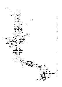
subject matter disclosed is capable of considerable modifications,
alterations,
combinations, and equivalents in form and function, as will occur to those
skilled
in the art and having the benefit of this disclosure.
[0004] FIG. 1 is an
illustration of an example directional drilling
system for drilling a wellbore.
[0005] FIG. 2 illustrates a
workflow of an exemplary analysis
method.
[0006] FIG. 3 illustrates a
representation of a subterranean
formation with several mineralogies with the target well path and actual well
path represented.
[0007] FIG. 4 illustrates a
wellbore trajectory for a deviated wellbore
used in the examples.
[0008] FIG. 5 is a
histogram of the values for the Young's modulus
along the initial wellbore trajectory in the example.
[0009] FIG. 6 is a
histogram of the values for the porosity along the
initial wellbore trajectory in the example.
[0010] FIG. 7 is a
histogram of the values for the total organic
content along the initial wellbore trajectory in the example.
1
CA 03041087 2019-04-17
WO 2018/118020 PCT/US2016/067735
[0011] FIG. 8 is a
histogram of the values for the weight-on-bit
along the initial wellbore trajectory in the example.
[0012] FIG. 9 is a
histogram of the values for the drill bit revolutions
per minute along the initial wellbore trajectory in the example.
[0013] FIG. 10 is a
histogram of the values for the drilling fluid flow
rate along the initial wellbore trajectory in the example.
[0014] FIG. 11 is a
histogram of the values for the drill bit rate of
penetration along an interval of the wellbore in the example.
[0015] FIGS. 12-13
illustrates the distributions of predicted
inclination and azimuth, respectively, at one location ahead of drill bit
in the
example.
[0016] FIG. 14 (top)
illustrates the weight-on-bit and drilling fluid
flow rate probability density distributions for effecting rate of penetration
in the
example and (bottom) illustrates the weight-on-bit and drilling fluid flow
rate
probability relative to cost in the example.
DETAILED DESCRIPTION
[0017] The present
application relates to controlling the trajectory of
a drill bit during a drilling operation by accounting for uncertainties in the
directional drilling system and the subterranean formation.
[0018] When attempting to
drill a projected wellbore path, the
variations in downhole conditions relative to the original model (e.g., a
variation
in the formation properties) and improper execution of the directional
drilling
system (e.g., the weight on bit or hydraulic pressure that steers the drill
bit
actually being a few percent less than instructed) are uncertainties that
may
cause the actual wellbore path to depart from the projected wellbore path. The
analyses, methods, and systems described herein use real-time data associated
with downhole conditions to mitigate an actual wellbore path from departing
from the projected wellbore path due to uncertainties.
[0019] FIG. 1 is an
illustration of an example directional drilling
system 100 for drilling a wellbore 102, in accordance with some embodiments of
the present disclosure. The wellbore 102 may include a wide variety of
profiles
or trajectories such that the wellbore 102 may be referred to as a
"directional
wellbore" or "deviated wellbore" having multiple sections or segments that
extend at a desired angle or angles relative to vertical. A directional
wellbore
2
CA 03041087 2019-04-17
WO 2018/118020 PCT/US2016/067735
may be formed by applying hydraulic pressure to one or more drill bit steering
components in the bottom hole assembly (BHA) 120 in order to steer the
associated drill bit 104 forming the wellbore 102. The amount of hydraulic
pressure may dictate the degree of change in the direction of the drill bit
104
such that the hydraulic pressure may indicate the trajectory of a
directional
wellbore 102.
[0020] The directional
drilling system 100 may include drilling
platform 106. However, teachings of the present disclosure may be applied to
wellbores using drilling systems associated with offshore platforms, semi-
submersible, drill ships and any other drilling system satisfactory for
forming a
wellbore extending through one or more downhole formations.
[0021] The drilling
platform 106 may be coupled to a wellhead 108.
Drilling platform 106 may also include rotary table 110, rotary drive motor
112,
and other equipment associated with rotation of drill string 114 within
wellbore
102. An annulus 116 may be formed between the exterior of drill string 114 and
the inside diameter of wellbore 102.
[0022] The directional
drilling system 100 may include various
downhole drilling tools and components associated with a measurement-while-
drilling (MWD) and/or logging-while-drilling (LWD) system 118 that provides
logging data and other information from the bottom of wellbore 102 to a
control
system 122. The control system 122 may also be communicably coupled to the
BHA 120 and the rotary drive motor 112.
[0023] The control system
122 may be a singular computer with one
or more processors for performing the analyses and methods described herein.
Alternatively, the control system 122 may comprise more than one processor
with processors associated with the different components of the directional
drilling system 100 that collectively perform the analyses and methods
described
herein.
[0024] The directional
drilling system 100 may include a plurality of
sensors 124 in addition to the MWD/LWD system 118 for measuring parameters
and data associated with a drilling operation (e.g., survey data, real-time
formation data, BHA parameters, and surface parameters, each described
further herein). For example, sensor 124a may be coupled to a flow pipe or
pump to measure the flow rate of the drilling fluid. In another example,
sensor
124b may be coupled to the rotary drive motor 112 or other suitable component
3
CA 03041087 2019-04-17
WO 2018/118020 PCT/US2016/067735
of the directional drilling system 100 to measure the revolutions per minute
(rpm) of the drill string. In yet another example, sensors 124c,124d may be
located at or near the drill bit 104 to ascertain the location of the drill
bit 104 in
the subterranean formation.
[0025] FIG. 2 illustrates a
workflow of an exemplary analysis
method 230, in accordance with some embodiments of the present disclosure.
The analysis method 230 includes several inputs, each designated by an
asterisk
in FIG. 2.
[0026] The analysis method
230 uses a formation model 232, which
originally was produced from original data 234 collected before drilling
(e.g.,
seismic data, offset well data, and formation data collected from other wells
in
the field) and is updated as the wellbore is drilled using real-time formation
data
236 (e.g., data collected during drilling with the MWD/LWD tools). In some
instances, an earth model may be used to produce and update the formation
model 232 from the described inputs.
[0027] The original data
234 and real-time formation data 236 may
be formation properties. As used herein, the term "formation properties," and
grammatical variants thereof, refers to a property of the rocks in the
formation
or a fluid therein that include, but are not limited to, mineralogy, Young's
modulus, brittleness, porosity, permeability, relative permeability, total
organic
content, water content, Poisson's ratio, pore pressure, and the like, and any
combination thereof.
[0028] The formation model
232 is a mathematical representation of
the subterranean formation that correlates the formation properties to a
location
within the formation. The mathematical representation may be a 3-dimensional
grid matrix of the subterranean formation (also known as a geocellular grid),
a
2-dimensional slice or topographical collapse of the 3-dimensional grid
matrix, a
1-dimensional array representing the subterranean formation, and the like. In
a
1-dimensional array, the data points that relate the formation property to a
location (e.g., the individual data points in the geocellular grid) are
converted to
a mathematical matrix having matrix identification values corresponding to
each
of the data points in the geocellular grid.
[0029] The formation model
232 may identify locations within the
formation with high total organic content and high porosity (sweet spots),
with
mineralogy difficult to drill, with high water content, and the like, and any
4
CA 03041087 2019-04-17
WO 2018/118020 PCT/US2016/067735
combination thereof. Based on the formation model 232, an ideal well path 238
is derived to preferably maximize intersection with the sweet spots in the
formation and minimize intersection with water and mineralogy difficult to
drill.
Then, the ideal well path 238 is adjusted to account for drillability factors,
like
dogleg severity and tortuosity, to produce a target well path 240. As used
herein, the term "drillability factors," and grammatical variants thereof,
refers to
physical and mechanical limitations to directional drilling through a
formation.
Alternatively, the target well path 240 may be derived based on the formation
model 232 to preferably maximize intersection with the sweet spots in the
formation and minimize intersection with water and mineralogy difficult to
drill
while accounting for drillability factors like dogleg severity and tortuosity.
[0030] Referring again to
the formation model 232, using the real-
time formation data 236 collected during drilling with the MWD/LWD tools, the
formation model 232 produces updated formation properties 242. For example,
gamma ray measurements and/or nuclear magnetic resonance measurements
from a MWD/LWD tool located along the drill string of a subterranean formation
may be used by the formation model 232 to calculate the porosity of the
surrounding formation.
[0031] Further, as an input
for the analysis method 230, sensors at
or near the drill bit (e.g., up to about 50 feet behind the drill bit along
the
drilling string) may be used to track the actual wellbore path by providing a
specific location of the sensors and/or the drill bit (referred to herein as
survey
data 244). Generally, the sensors provide measurements of the sensor location,
but in some instances, a mathematical model (not illustrated) may include
additional computations to estimate the drill bit location relative to the
sensors.
As used herein, the term "survey data," and grammatical variants thereof,
refers
to the data that describes the location of the sensors and/or the drill bit in
the
subterranean formation. The survey data 244 may include, but are not limited
to, inclination, azimuth, measured depth (distance along the actual well path
from the wellhead, which is typically calculated or otherwise derived from
survey
data), and the like, and any combination thereof.
[0032] Another input for
the analysis method 230 is BHA parameters
246. As used herein, the term "BHA parameters," and grammatical variants
thereof, are the data that describes the direction the drill bit is pointing
relative
to a central longitudinal axis of the drill string closest to the drill bit.
Exemplary
5
CA 03041087 2019-04-17
WO 2018/118020 PCT/US2016/067735
BHA parameters 246 may include, but are not limited to, tool face angle, tilt
angle, steering pad displacement, and the like, and any combination thereof.
[0033] Finally, surface
parameters 248 are included as a method
input. As used herein, the term "surface parameters," and grammatical variants
thereof, are the data that describes the conditions of the drilling operation
that
can be measured or controlled at the surface. Exemplary surface parameters
248 may include, but are not limited to, revolutions per minute of the drill
string
(and consequently the drill bit), weight on bit, drilling fluid flow rate,
drilling fluid
weight, and the like, and any combination thereof.
[0034] Each of the BHA
parameters 246 and surface parameters 248
may be the values an operator or the control system inputs or may be the
actual
values detected by an appropriately placed sensor.
[0035] The updated
formation properties 242, the survey data 244,
the BHA parameters 246, and the surface parameters 248 are used to model a
series of trajectory well paths 250 for the drill bit. Each of the trajectory
well
paths 250 may be characterized as a series of Cartesian coordinates (X,, Y,,
Z,),
where i =1, 2, 3, ..., k, k+1, k+2, ... and k represents the current
timestamp.
The Cartesian coordinates (X,, Y,, Z,) can be calculated from the measured
depth
of the survey data 244 (e.g., inclination (in), azimuth (az), and measured
depth
(md)). Therefore, in some instances, the trajectory well paths 250 may
alternatively be characterized by corresponding coordinates (in,, az,, md,).
[0036] Generally, the real-
time formation data 236 collected during
drilling with the MWD/LWD tools and the survey data 244 lag because (1) the
MWD/LWD tools are usually located several to tens of feet behind the drill bit
and (2) accurate gyroscope data for the survey data 244 requires stationary
measurement so the gyroscope data may be taken after drill bit advances the
distance of pipe stand (typically 30 or 90 feet). Therefore, trajectory well
paths
250 provide a probabilistic analysis of the current drill bit position and the
future
drill bit position.
[0037] For example, FIG. 3
illustrates a representation of a
subterranean formation 370 with several mineralogies 370a,370b,370c where
the sweet spot 370c is at the central mineralogy. The target well path 340 and
actual well path 352 are illustrated as passing through the sweet spot. The
window of uncertainty 372 is produced when combining the trajectory well paths
6
CA 03041087 2019-04-17
WO 2018/118020 PCT/US2016/067735
using the probabilistic methodology. The actual drill bit location 374 is
within the
window of uncertainty 372 because of the lag discussed above.
[0038] Referring again to
FIG. 2, each of the updated formation
properties 242, the survey data 244, the BHA parameters 246, and the surface
parameters 248 also have uncertainties related thereto arising from components
being slightly off calibration, general measurement/experimental error,
response
time of components (e.g., BHA components) to instructions received, the
location of sensors and MWD/LWD tools relative to the drill bit, and the like,
and
any combination thereof. The analysis method 230 accounts for these
uncertainties by modeling a series of trajectory well paths 250.
[0039] The trajectory well
paths 250 are combined using a
probabilistic methodology to produce the actual well path 252 that may extend
to the drill bit location 374 of FIG. 3 or beyond depending on the operator's
preferences.
[0040] Referring again to
FIG. 2, using the target well path 240 and
actual well path 252, a deviation 254 between the target well path 240 and the
actual well path 252 is determined. The deviation 254 may be expressed as a
normal distribution N(pAp, crAp), where Lip is the length of deviation vector,
[JAI:, is
the mean value of the normal distribution, and oAr, is the standard deviation
of
the normal distribution].
[0041] Then, a threshold
256 for the deviation 254 (e.g., about 1
feet or less at the drill bit location or about 2 feet or less at 5 feet
beyond the
drill bit location) is applied. If the deviation 254 is within the threshold
256, the
drilling continues 258 under the present conditions (e.g., with the present
BHA
parameters 246 and the present surface parameters 248). Alternatively, if the
deviation 254 is beyond the threshold 256, adjustments 260 may be made in the
BHA parameters 246 and the surface parameters 248 to bring the deviation 254
within the threshold 256.
[0042] The foregoing
methods and analyses may be performed, at
least in part, using a control system (e.g., control system 122 of FIG. 1).
The
processor and corresponding computer hardware used to implement the various
illustrative blocks, modules, elements, components, methods, and algorithms
described herein may be configured to execute one or more sequences of
instructions, programming stances, or code stored on a non-transitory,
computer-readable medium (e.g., a non-transitory, tangible, computer-readable
7
CA 03041087 2019-04-17
WO 2018/118020 PCT/US2016/067735
storage medium containing program instructions that cause a computer system
running the program of instructions to perform method steps or cause other
components/tools to perform method steps described herein). The processor can
be, for example, a general purpose microprocessor, a microcontroller, a
digital
signal processor, an application specific integrated circuit, a field
programmable
gate array, a programmable logic device, a controller, a state machine, a
gated
logic, discrete hardware components, an artificial neural network, or any like
suitable entity that can perform calculations or other manipulations of data.
In
some embodiments, computer hardware can further include elements such as,
for example, a memory (e.g., random access memory (RAM), flash memory,
read only memory (ROM), programmable read only memory (PROM), erasable
programmable read only memory (EPROM)), registers, hard disks, removable
disks, CD-ROMS, DVDs, or any other like suitable storage device or medium.
[0043] Executable sequences
described herein can be implemented
with one or more sequences of code contained in a memory. In some
embodiments, such code can be read into the memory from another machine-
readable medium. Execution of the sequences of instructions contained in the
memory can cause a processor to perform the methods and analyses described
herein. One or more processors in a multi-processing arrangement can also be
employed to execute instruction sequences in the memory. In addition, hard-
wired circuitry can be used in place of or in combination with software
instructions to implement various embodiments described herein. Thus, the
present embodiments are not limited to any specific combination of hardware
and/or software.
[0044] As used herein, a
machine-readable medium will refer to any
medium that directly or indirectly provides instructions to a processor for
execution. A machine-readable medium can take on many forms including, for
example, non-volatile media, volatile media, and transmission media. Non-
volatile media can include, for example, optical and magnetic disks. Volatile
media can include, for example, dynamic memory. Transmission media can
include, for example, coaxial cables, wire, fiber optics, and wires that form
a
bus. Common forms of machine-readable media can include, for example, floppy
disks, flexible disks, hard disks, magnetic tapes, other like magnetic media,
CD-
ROMs, DVDs, other like optical media, punch cards, paper tapes and like
physical
media with patterned holes, RAM, ROM, PROM, EPROM, and flash EPROM.
8
CA 03041087 2019-04-17
WO 2018/118020 PCT/US2016/067735
[0045] Embodiments
described herein include, but are not limited
to, Embodiment A, Embodiment B, and Embodiment C.
[0046] Embodiment A is a
method comprising: drilling a deviated
wellbore penetrating a subterranean formation according to bottom hole
assembly parameters and surface parameters; collecting real-time formation
data during drilling; updating a model of the subterranean formation based on
the real-time formation data and deriving formation properties therefrom;
collecting survey data corresponding to a location of a drill bit in the
subterranean formation; deriving a target well path for the drilling based on
the
model of the subterranean formation; deriving a series of trajectory well
paths
based on the formation properties, the survey data, the bottom hole assembly
parameters, and the surface parameters and uncertainties associated therewith;
deriving an actual well path based on the series of trajectory well paths;
deriving
a deviation between the target well path and the actual well path; and
adjusting
the bottom hole assembly parameters and the surface parameters to maintain
the deviation below a threshold.
[0047] Embodiment B is a
system comprising: a drill string
extending into a deviated wellbore penetrating a subterranean formation and
having a bottom hole assembly and a drill bit at a distal end of the drill
string; a
plurality of sensors in various locations of the system to detect real-time
formation data, survey data corresponding to a location of the drill bit in
the
subterranean formation, bottom hole assembly parameters, and surface
parameters; a non-transitory computer-readable medium communicably coupled
to the plurality of sensor and the bottom hole assembly and encoded with
instructions that, when executed, cause the system to perform a method
according to Embodiment A.
[0048] Embodiment C is a
non-transitory computer-readable
medium encoded with instructions that, when executed, cause a system to
perform a method according to Embodiment A.
[0049] Embodiments A, B,
and C may optionally include one or more
of the following: Element 1: wherein the threshold is 10 feet or less at the
drill
bit; Element 2: wherein deriving a target well path for the drilling based on
the
model of the subterranean formation comprises: deriving an ideal well path for
the drilling based on the model of the subterranean formation that maximizes
intersection between the ideal well path and sweet spots in the subterranean
9
CA 03041087 2019-04-17
WO 2018/118020 PCT/US2016/067735
formation; and adjusting the ideal well path to account for drillability
factors,
thereby producing the target well path; Element 3: wherein the bottom hole
assembly parameters comprise at least one selected from the group consisting
of: tool face angle, tilt angle, steering pad displacement, and any
combination
thereof; Element 4: wherein the surface parameters comprise at least one
selected from the group consisting of: revolutions per minute of the drill
string,
weight on bit, drilling fluid flow rate, drilling fluid weight, and any
combination
thereof; Element 5: wherein the formation properties comprise at least one
selected from the group consisting of: mineralogy, Young's modulus,
brittleness,
porosity, permeability, relative permeability, total organic content, water
content, Poisson's ratio, pore pressure, and any combination thereof; Element
6:
wherein the survey data comprise at least one selected from the group
consisting of: inclination, azimuth, measured depth, and any combination
thereof. By way of nonlimiting example, the following combinations may be
applied to Embodiments A, B, and C: Element 1 in combination with Element 2;
two or more of Elements 3-6 in combination; Element 1 in combination with one
or more of Elements 3-6 in combination; Element 2 in combination with one or
more of Elements 3-6 in combination; and Elements 1 and 2 in combination with
one or more of Elements 3-6 in combination.
[0050] Unless otherwise
indicated, all numbers expressing quantities
of ingredients, properties such as molecular weight, reaction conditions, and
so
forth used in the present specification and associated claims are to be
understood as being modified in all instances by the term "about."
Accordingly,
unless indicated to the contrary, the numerical parameters set forth in the
following specification and attached claims are approximations that may vary
depending upon the desired properties sought to be obtained by the
embodiments of the present invention. At the very least, and not as an attempt
to limit the application of the doctrine of equivalents to the scope of the
claim,
each numerical parameter should at least be construed in light of the number
of
reported significant digits and by applying ordinary rounding techniques.
[0051] One or more
illustrative embodiments incorporating the
invention embodiments disclosed herein are presented herein. Not all features
of
a physical implementation are described or shown in this application for the
sake
of clarity. It is understood that in the development of a physical embodiment
incorporating the embodiments of the present invention, numerous
CA 03041087 2019-04-17
WO 2018/118020
PCT/US2016/067735
implementation-specific decisions must be made to achieve the developer's
goals, such as compliance with system-related, business-related, government-
related and other constraints, which vary by implementation and from time to
time. While a developer's efforts might be time-consuming, such efforts would
be, nevertheless, a routine undertaking for those of ordinary skill in the art
and
having benefit of this disclosure.
[0052]
While compositions and methods are described herein in
terms of "comprising" various components or steps, the compositions and
methods can also "consist essentially of" or "consist of" the various
components
and steps.
[0053] To
facilitate a better understanding of the embodiments of
the present invention, the following examples of preferred or representative
embodiments are given. In no way should the following examples be read to
limit, or to define, the scope of the invention.
EXAMPLES
[0054]
FIG. 4 illustrates an initial wellbore trajectory for a deviated
wellbore where the wellhead is at 0 ft horizontal departure and 0 ft true
vertical
depth.
[0055] Based on
formation data collected from various wellbore logs,
an earth model was used to calculate the formation properties, specifically,
Young's modulus, porosity, and total organic content, along the initial
wellbore
trajectory. The data sets for each of the formation properties can be
described
approximately as three normal distributions N (p, a) as shown in Table 1.
Alternatively or in addition to the normal distributions, the histograms of
the
values for the formation properties along the initial wellbore trajectory are
illustrated in FIGS. 5-7.
Table 1
Statistics Summary
Formation Property
Mean
Standard Deviation
Young's Modulus (106 psi) 4.49746 0.756482
Porosity (pore-volume fraction) 0.128446 0.026418
Total organic carbon (weight %) 3.055555 1.177536
11
CA 03041087 2019-04-17
WO 2018/118020
PCT/US2016/067735
[0056]
Using the earth model and petrophysical proxies, the sweet
spots were determined to be at locations along the wellbore trajectory having
a
Young' modulus > 5 Pa, total organic content > 4 ppm, and porosity > 0.12
pore-volume fraction.
[0057] The
probability of success for intersecting sweet spots was
calculated for the locations around the initial wellbore trajectory. An ideal
well
path (e.g., ideal well path 238 of FIG. 2) is established by those locations
with
highest probabilities of success. However, this ideal well path was not
necessarily the best target well path to drill. Further adjustment were made
to
produce a target well path (e.g., target well path 240 of FIG. 2) to account
for
drillability factors as described herein.
[0058] The
wellbore trajectory ahead of the latest survey location
was then simulated with an attempt to achieve the target well path. The actual
well path (e.g., actual well path 252 of FIG. 2) is related to both surface
parameters and formation properties. As mentioned above, formation properties
exhibit uncertainties. In reality, the surface parameters like weight-on-bit,
drill
bit revolutions per minute, drilling fluid flow rate, and the like also
exhibit
uncertainties. The data sets for each of the surface parameters can be
described
approximately as three normal distributions N (p, a) as shown in Table 2.
Alternatively or in addition to the normal distributions, the histograms of
the
values for the surface parameters along the initial wellbore trajectory are
illustrated in FIGS. 8-10.
Table 2
Statistics Summary
Surface Parameter
Mean Standard deviation
Weight-on-Bit 17.0321 2.2403
(thousands of lbs)
Revolutions per Minute 100.25 2.0885
Drilling Fluid Flow Rate 701.05 1.1115
(gallons per minute)
[0059]
Due, at least in part, to the uncertainties of surface
parameters and formation properties, the recorded rate of penetration for the
12
CA 03041087 2019-04-17
WO 2018/118020 PCT/US2016/067735
interval of 8000 - 8030 ft varied with a mean of 174.078 ft/hr and standard
deviation of 13.63 ft/hr. The histogram of the rate of penetration for this
drilling
interval is illustrated in FIG. 11. Therefore, uncertainty in the surface
parameters
and formation properties cause fluctuation sin the rate of penetration, which
ultimately will cause uncertainty of actual well path.
[0060] Assuming the bottom
hole assembly tool responds very
accurately without error, statistical methods (e.g., Monte Carlo, Hypercube,
and
FORM (First Order Reliability Method)) may be used to compute the actual well
path with quantified uncertainties, as shown in Table 3. All position-related
data
can be described as normal distributions N (p, a) where the mean value and
standard deviation are computed in real-time. FIGS. 12-13 shows the
distributions of predicted inclination and azimuth at one location ahead of
drill
bit.
Table 3
Azimuth
Meas. Inclination ( ) Dogleg
(0) Prob. of Data
Depth Severity
Std. Std. Overlap Source
(ft) Mean Mean ( /100 ft)
dev. dev.
n 91.8 0.05 316.4 0.250 1.00 1.2
Survey
n+30 91.9 0.8332 316.8 2.2087 0.98 1.0
Predict
n+60 92.1 0.8636 315.6 2.1090 0.97 0.8
Predict
n+90 90.0 0.9445 314.7 2.6586 0.96 0.6
Predict
n+96 91.6 0.9565 315.9 2.6987 0.96 0.6
Predict
[0061] A single probability
of overlapping between actual well path
and target well path was also computed, as shown in Table 3. Appropriate
acceptance criteria can be pre-determined based on experience. For example,
probability of overlapping > 0.90 and predicted dogleg severity < 3.0 0/100 ft
may be used for achieving smooth well path with maximum access to sweet
spots. If either requirement is not met, the computer program may search for
combinations of weight-on-bit, drill bit revolutions per minute, and drilling
fluid
13
CA 03041087 2019-04-17
WO 2018/118020 PCT/US2016/067735
flow rate, as well as bottom hole assembly orientation adjustments, to change
of
well path until the criteria are met.
[0062] The adjustments of
the surface parameters and formation
properties may be weighted. For example, wt=60% of adjustment goes to
bottom hole assembly orientation, (1-wt) = 40% adjustment goes to surface
parameters. The value of wt may be pre-optimized using historical data.
[0063] Through a close-loop
feedback process (e.g., illustrated in
FIG. 2), the actual well path can be controlled in a proactive manner. For
example, the probability density distributions of each input and output
variables
change, which allows them to be compared against each other depending on the
outcome. For example, the weight-on-bit and drilling fluid flow rate
probability
density distributions for effecting rate of penetration are illustrated in the
upper
plot of FIG. 14.
[0064] Tradeoffs involving
cost and probability of the desired
operating variables may also be considered. For example, the weight-on-bit and
drilling fluid flow rate probability from the upper plot of FIG. 14 are
replotted
relative to the cost to change the surface parameter in the bottom plot of
FIG.
14.
[0065] Expanding on this
example, additional surface parameters
and their probability levels at a plurality of difference scenarios may be
estimated and threshold values for each surface parameter may be set for
maximizing the rate of penetration.
[0066] Therefore, the
present invention is well adapted to attain the
ends and advantages mentioned as well as those that are inherent therein. The
particular embodiments disclosed above are illustrative only, as the present
invention may be modified and practiced in different but equivalent manners
apparent to those skilled in the art having the benefit of the teachings
herein.
Furthermore, no limitations are intended to the details of construction or
design
herein shown, other than as described in the claims below. It is therefore
evident that the particular illustrative embodiments disclosed above may be
altered, combined, or modified and all such variations are considered within
the
scope and spirit of the present invention. The invention illustratively
disclosed
herein suitably may be practiced in the absence of any element that is not
specifically disclosed herein and/or any optional element disclosed herein.
While
compositions and methods are described in terms of "comprising," "containing,"
14
CA 03041087 2019-04-17
WO 2018/118020
PCT/US2016/067735
or "including" various components or steps, the compositions and methods can
also "consist essentially of" or "consist of" the various components and
steps. All
numbers and ranges disclosed above may vary by some amount. Whenever a
numerical range with a lower limit and an upper limit is disclosed, any number
and any included range falling within the range is specifically disclosed. In
particular, every range of values (of the form, "from about a to about b," or,
equivalently, "from approximately a to b," or, equivalently, "from
approximately
a-b") disclosed herein is to be understood to set forth every number and range
encompassed within the broader range of values. Also, the terms in the claims
.. have their plain, ordinary meaning unless otherwise explicitly and clearly
defined
by the patentee. Moreover, the indefinite articles "a" or "an," as used in the
claims, are defined herein to mean one or more than one of the element that it
introduces.