Note: Descriptions are shown in the official language in which they were submitted.
SYSTEMS AND METHODS FOR LOCATING RAILROAD COMPONENTS
ALONG A PREDETERMINED PATH
[0001] Blank.
Field of the Disclosure
[0002] The embodiments described herein relate generally to a system to
mark or locate
assets along a predetermined path. In particular, the disclosure relates to a
guidance system
to compare and correlate data sets collected over the same railroad track at
different times in
order to verify the location of the system on the subsequent pass. Also, the
disclosure relates
to an automated system to mark railroad components, such as crossties, to be
replaced or
repaired Some embodiments within the disclosure relate to physical marking of
railroad
components.
BACKGROUND
[0003] Railroad components, such as crossties (-ties"), are exposed to
mechanical,
chemical, and environmental forces and over time, the condition of the
railroad components
may degrade, such that it no longer functions effectively. In the case of
ties, the degraded ties
may no longer support the railroad track loads and/or provide a fixed track
gage. The
condition of the railroad components may be inadequate for a desired purpose
or may need to
otherwise be replaced. For instance, a sufficient number of ties within a
certain length of
track may have degraded and therefore need to be replaced rail spaces may be
missing,
and/or a rail may have become damaged.
[0004] A railroad company may replace damaged ties with specialized
machines
designed to traverse the track to remove selected ties and replace them with
new ties to
1
Date Recue/Date Received 2020-08-05
CA 03042288 2019-04-29
WO 2018/187420
PCT/US2018/026011
restore the track to a suitable service condition. Likewise, specialized
machines and/or
railroad workers may replace other railroad components, such as joint bars,
tie plates,
fasteners, spikes, and rails. However, in order to designate which ties are to
be removed from
a track and replaced, a railroad worker will typically walk along the ties and
create a paint
mark on or near the tie to be removed as an indicator for the crew replacing
ties. In some
cases, the railroad worker will exercise his discretion to select the correct
ties to be replaced.
A walking tie marking worker may achieve a walking rate of 1-2 miles per hour,
depending
on several factors such as track condition and if he must make on the spot
decisions about
which ties to replace. If he is allowed to make subjective decisions about
which ties may be
replaced, he may erroneously leave behind ties in very poor condition or
replace ties in
relatively good condition. In addition, individualized analysis by the worker
is time
consuming and may be undesirable. Non-optimal tie replacement can have
significant
economic effects on a railroad's capital and maintenance budgets by replacing
ties before
they have reached the end of their useful lives, and by leaving behind
conditions that will
require earlier maintenance interventions than desired. In addition, railroad
workers walking
along railroad tracks may increase the opportunity for accidents and/or may
decrease useable
track time.
SUMMARY
100051 The present disclosure is directed to systems and methods that
overcome some of
the problems and disadvantages discussed above. Other disadvantages may exist.
Furthermore, although the embodiments described below have been described in
the context
of the railroad industry, it is appreciated that the system and methods
disclosed herein may be
used to mark or service other assets positioned along a predetermined path.
For example, the
systems and methods described herein may be used to mark damaged or missing
lane markers
2
CA 03042288 2019-04-29
WO 2018/187420
PCT/US2018/026011
along a highway, potholes to be repaired along a road, or trip hazards and
separated concrete
on a sidewalk or trail.
[0006] An embodiment of a system for marking assets along a predetermined path
includes a marking tool and a controller. The marking tool is configured to
travel along the
predetermined path and place indicators, visual or others such as RFID,
chemical, or optical
markers, upon or near assets. The controller includes programming to implement
a guidance
plan. The guidance plan may include a position of the asset along the
predetermined path to
be marked by the marking tool. The system may include a trigger to initiate
and terminate the
operation of the marking tool. The trigger may be integral to the marking
tool. The controller
is in communication with the trigger to implement the guidance plan.
[0007] The system may include a rail-traversing vehicle. The marking tool
may be
mounted on the rail-traversing vehicle or on a trailer configured to be towed
by the rail-
traversing vehicle. The system may include a coordinate locating system
configured to
provide a real-time location of the marking tool. The coordinate locating
system may include
a GPS system. The coordinate locating system may include an encoder.
[0008] The controller may include one or more algorithms configured to
compare and
correlate the real-time location of the marking tool with the position of one
of the assets. The
system may include an inspection system configured to obtain current features
of assets along
the predetermined path. The controller may include programming to compare and
correlate
the current features of the assets with prior features of the assets to
determine a location of
the marking tool relative to the one of the assets. The prior features of the
assets may be
included within the guidance plan. The controller may include programming to
compare and
correlate the current features of a reference component with prior features of
the reference
component to determine a location of the marking tool relative to the one of
the assets to be
3
CA 03042288 2019-04-29
WO 2018/187420
PCT/US2018/026011
marked. The position of the one of the assets may be a known relative position
from the
reference component.
[0009] An embodiment of a method for marking assets along a predetermined path
includes obtaining a guidance plan identifying assets along a predetermined
path, traversing
the predetermined path with a marking tool, using a processor to correlate a
location of the
marking tool with a position of one of the assets identified in the guidance
plan, signaling the
marking tool with the processor when the marking tool is aligned with one of
the assets
identified in the guidance plan, and marking the assets identified in the
guidance plan.
[0010] The method
may include generating the guidance plan identifying the assets along
the predetermined path. Generating the guidance plan identifying the assets
along the
predetermined path may include performing a survey along the predetermined
path,
identifying the assets and the positions of the assets along the predetermined
path, analyzing
the condition of the assets, and generating the guidance plan identifying
specific assets along
the predetermined path. The method may include inspecting the predetermined
path and
obtaining current features of the assets along the predetermined path. Using a
processor to
correlate a location of the marking tool with a position of one of the assets
may include
obtaining prior features of the assets along the predetermined path, and using
the processor to
compare and correlate the current features with the prior features to
determine the location of
the marking tool relative to the position of one of the assets identified in
the guidance plan.
[0011] An embodiment of a system for locating components along a predetermined
path
includes an inspection system, survey data, and a controller. The inspection
system is
configured to travel along a predetermined path and obtain inspection data.
The inspection
data corresponds to features of the predetermined path. The survey data
corresponds to
features of the predetermined path at a time earlier than the inspection data.
The controller
has one or more processors, configured to analyze the inspection data by
applying one or
4
CA 03042288 2019-04-29
WO 2018/187420
PCT/US2018/026011
more algorithms to compare and correlate the features in the inspection data
with the features
in the survey data to determine a location of the system.
[0012] The inspection data may include a first image of a portion of the
predetermined
path and the survey data may include a second image of a portion of the
predetermined path.
The system may include a guidance plan having an identity and position for an
asset along
the predetermined path. The system may include a tool configured to travel
along the
predetermined path. The controller is in communication with the tool, and the
controller
include programming to operate the tool in accordance with the guidance plan.
The guidance
plan may include an action corresponding to the asset in the guidance plan.
The tool may be a
marking tool configured to place physical indicators upon or near the asset,
and the controller
may include programming to initiate and terminate operation of the marking
tool.
[0013] The physical indicators may include one or more of a paint mark, a
RFID tag, a
reflective fluid, a chemical indicator, or a combination or subset thereof The
predetermined
path may a railroad track and the system may include a rail-traversing
vehicle. The tool may
be mounted on the rail-traversing vehicle. The tool may be mounted on a
trailer configured to
be towed behind the rail-traversing vehicle. The system may include a
coordinate locating
system configured to provide a real-time location of the tool. The coordinate
locating system
may include an encoder. The inspection data and the survey data may each
include features of
one or more reference components, and the controller includes one or more
algorithms
configured to compare and correlate the features of the one or more reference
components in
the inspection data with the features of the one or more reference components
in the survey
data to determine a location of the tool relative to the asset, the position
of the asset being a
known relative position from the one or more reference components.
[0014] An embodiment of a method for locating components along a predetermined
path
includes obtaining survey data of a predetermined path and traversing the
predetermined path
CA 03042288 2019-04-29
WO 2018/187420
PCT/US2018/026011
with an inspection system. The survey data includes previous features of the
predetermined
path. The method includes using the inspection system to obtain inspection
data of the
predetermined path, the inspection data including current features of the
predetermined path,
and using one or more processors, comparing and correlating the current
features and the
previous features to determine a position of the inspection system.
[0015] The method may include obtaining a guidance plan, the guidance plan
including
an identity and a position of each of a plurality of assets along the
predetermined path. The
method may include aligning a tool with one of the plurality of assets after
determining the
position of the inspection system. The tool may be a marking tool, and the
method may
include signaling the marking tool with the one or more processors when the
marking tool is
aligned with one of the plurality of assets, and marking the plurality of
assets. Obtaining the
guidance plan may comprise generating the guidance plan by performing a survey
of the
predetermined path, identifying a plurality of components along the
predetermined path,
analyzing a condition of the plurality of components, identifying a subset of
the plurality of
components as the plurality of assets, and generating the guidance plan with
the plurality of
assets.
[0016] The predetermined path may be a railroad track and the plurality of
assets may be
a plurality of railroad components. The plurality of railroad components may
include railroad
ties. The current features may include a relative spacing of a group of the
railroad ties and the
previous features may include the relative spacing of the group of railroad
ties. The
inspection data may include a first image of a portion of the railroad track
and the survey data
may include a second image of a portion of the railroad track.
[0017] An embodiment of a method for locating railroad components along a
railroad
track includes obtaining a guidance plan and obtaining inspection data. The
guidance plan
includes an identity of each of a plurality of assets, the identity including
previous features of
6
CA 03042288 2019-04-29
WO 2018/187420
PCT/US2018/026011
the assets. The assets may be railroad components. The inspection data
includes current
features of a plurality of railroad components along the railroad track. The
method includes
using one or more processors, comparing and correlating the current features
of the plurality
of railroad components with the previous features of the assets to determine
which of the
plurality of railroad components corresponds with the plurality of assets.
[0018] The comparing and correlating may be performed while traversing the
railroad
track. The identity of each of the plurality of assets may include a position
of the asset. The
position of the asset may be comprised of an identity of one or more reference
components
and a relative position of the asset with respect to the one or more reference
components. The
plurality of assets may include railroad ties. The previous features of the
railroad ties may
include a relative spacing of a group of the railroad ties. The previous
features of the railroad
ties may include a leading edge and a trailing edge of the railroad ties.
[0019] The method may include traversing the railroad track with a tool and
aligning the
tool with one of the plurality of assets. The method may include repairing or
replacing the
one of the plurality of assets using the tool. The method may include
physically marking the
one of the plurality of assets using the tool. At least some of the plurality
of railroad
components may include an RF1D tag with a component identifier and the
previous features
of the plurality of assets may include the component identifier. The method
may include
creating an alert when one of the plurality of railroad components correlated
to one of the
plurality of assets contains current features that are different from the
previous features.
[0020] An embodiment of a method for locating railroad components along a
railroad
track includes obtaining a guidance plan and obtaining inspection data. The
inspection data
includes current features of a plurality of railroad components along a
railroad track. The
guidance plan includes an identity of each of a plurality of assets along the
railroad track. The
7
CA 03042288 2019-04-29
WO 2018/187420
PCT/US2018/026011
assets may be railroad components. The method includes traversing the railroad
track with a
tool and aligning the tool with one of the plurality of assets.
[0021] The method may include traversing the railroad track with an
inspection system to
obtain the inspection data and the tool traversing the railroad track behind
the inspection
system. The tool may be positioned within a consist with the inspection
system. The identity
of each of the plurality of assets may include one or more of a known position
of the tool
with respect to the inspection system, a velocity of the inspection system
along the railroad
track, a velocity of the tool along the railroad track, or real-time location
coordinates from a
coordinate locating system. The real-time location coordinates may be encoder
measurements. The method may include generating the guidance plan from the
inspection
data.
[0022] The identity may include previous features of the assets. The method
may include
using one or more processors, comparing and correlating the current features
of the plurality
of railroad components with the previous features of the assets to determine
which of the
plurality of railroad components corresponds with the plurality of assets. The
comparing and
correlating may be performed while traversing the railroad track. The identity
of each of the
plurality of assets may include a position of the asset. The position of the
asset may be
comprised of an identity of one or more reference components and a relative
position of the
asset with respect to the one or more reference components. The plurality of
assets may
include railroad ties. The previous features of the railroad ties may include
a relative spacing
of a group of the railroad ties. The previous features of the railroad ties
may include a leading
edge and a trailing edge of the railroad ties.
[0023] At least some of the plurality of railroad components may include an
RFID tag
with a component identifier and the previous features of the plurality of
assets may include
the component identifier. The method may include creating an alert when one of
the plurality
8
CA 03042288 2019-04-29
WO 2018/187420
PCT/US2018/026011
of railroad components correlated to one of the plurality of assets contains
current features
that are different from the previous features. The method may include
repairing or replacing
the one of the plurality of assets using the tool. The method may include
physically marking
the one of the plurality of assets using the tool.
[0024] An embodiment of a method for locating railroad components along a
railroad
track includes traversing a railroad track with an inspection system, using
the inspection
system to obtain inspection data of the railroad track, and generating a
guidance plan. The
inspection data includes current features of a plurality of railroad
components along the
railroad track. The guidance plan is generated by using one or more
processors, applying a set
of rules or statistical analysis to the inspection data to identify a subset
of the plurality of
railroad components to be serviced or marked, and selecting the subset of the
plurality of
railroad components as a plurality of assets within the guidance plan. The
guidance plan
includes a position of each of the plurality of assets along the railroad
track. The traversing
the railroad track with the inspection system and the generating the guidance
plan are
performed in a single pass along the railroad track. The method may include
traversing the
railroad track with a tool and aligning the tool with one of the plurality of
assets using the
guidance plan. The tool may form part of the same consist as the inspection
system.
BRIEF DESCRIPTION OF THE DRAWINGS
[0025] FIG. 1 shows an embodiment of a system for locating and servicing
assets along a
predetermined path;
[0026] FIG. 2 shows an embodiment of a guidance plan;
[0027] FIG. 3 shows an embodiment of an asset position of an embodiment of a
guidance
plan;
[0028] FIG. 4 shows an embodiment of a method of identifying assets along a
predetermined path;
9
CA 03042288 2019-04-29
WO 2018/187420
PCT/US2018/026011
[0029] FIG. 5 shows an embodiment of a method of identifying assets along a
predetermined path;
[0030] FIG. 6 shows an exemplary embodiment of an impulse signal from
inspection
data;
[0031] FIG. 7 shows an exemplary embodiment of an impulse signal from
survey data;
[0032] FIG. 8 shows an exemplary embodiment of a cross correlation between
the
embodiments of FIGS. 6 and 7; and
[0033] FIG. 9 is an illustration of a side-by-side comparison of survey
data to inspection
data of the same portion of railroad track.
[0034] While the disclosure is susceptible to various modifications and
alternative forms,
specific embodiments have been shown by way of example in the drawings and
will be
described in detail herein. However, it should be understood that the
disclosure is not
intended to be limited to the particular forms disclosed. Rather, the
intention is to cover all
modifications, equivalents and alternatives falling within the scope of the
invention as
defined by the appended claims.
DETAILED DESCRIPTION
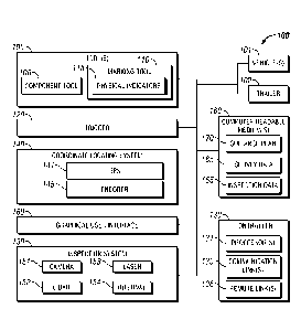
[0035] An embodiment of a system 100 for locating and servicing assets,
such as railroad
components, along a predetermined path, such as a railroad track, is shown in
FIG. 1. The
system 100 includes one or more tools 105, an inspection system 150, and one
or more
computer readable mediums 160 capable of storing data. The tools 105 may be
located a
known distance from the inspection system 150. By way of example, the tools
105 may be a
component tool 106 for servicing a railroad component and/or a marking tool
110. Examples
of a component tool 106 include machines in a tie gang, to remove or install
spikes, to
remove or install tie plates, to remove or install clips or insulators, to
remove or install a tie,
to install, apply epoxy to, or adz a tie, to inject filler into a hollow tie,
to tight bolts of a
fastener or joint bar, or to repair a raiL In addition, the component tool 106
may be an alarm
system used by railroad workers to alert the railroad worker when an action
should be taken,
or a remote device, such as a drone, to be controlled in relation to the
location of a particular
component on the railroad track.
[0036] The inspection system 150 is configured to scan and collect features
of the
predetermined path, such as a component's characteristics, including thermal
characteristics,
surface profile, position coordinates, and internal characteristics, and/or an
image of the
predetermined path and components along the predetermined path. The inspection
system
150 may include one or more of a camera 151, LiDAR 152, laser 153, or internal
imaging
system 154, such as x-ray or neutron inspection systems. The inspection system
150 may
include a 2D or 3D machine vision system. The inspection system 150 may
include a system
described in U.S. Patent No. 9,441,956, entitled -System and Method for
Inspecting Railroad
Ties" filed on January 19, 2015. The internal imaging system 154 may include a
system
described in U.S. Patent No. 9,031,188, entitled Internal Imaging System"
filed on
February 7, 2013.
[0037] The computer readable mediums 160 are capable of storing current
inspection
data 155, a guidance plan 170, and survey data 165. The inspection system 150
traverses and
examines the predetermined path to collect the inspection data 155, which is
compared with
previously collected survey data 165 of the same path. The current inspection
data 155 and
survey data 165 each includes features of the predetermined path, such as a
component's
characteristics, including thermal characteristics, surface profile, position
coordinates, and
internal characteristics, and/or an image of the predetermined path and
components along the
predetermined path. As used herein, historical data of the predetermined path
is referred to as
survey data while current data is referred to as inspection data. However, the
survey data 165
11
Date Recue/Date Received 2020-08-05
CA 03042288 2019-04-29
WO 2018/187420
PCT/US2018/026011
and the inspection data 155 include the same or overlapping categories of
information, and in
some embodiments may be gathered using the same system and analysis. The
inspection data
155 may be gathered during a current pass while the survey data 165 may be
gathered during
one or more prior passes along the predetermined path. The survey data 165 may
be compiled
using information gathered from multiple surveys. Multiple surveys may be used
to track
characteristics over time; such as if a component changes positions, is
wearing at an
accelerated rate, or is subject to fluctuations in heat.
[0038] Both the survey data 165 and the inspection data 155 may be gathered
using the
same inspection system 150. In some embodiments, the survey data 165 and the
inspection
data 155 may be gathered using different systems. For example, survey data 165
may be
collected by a drone traversing the predetermined path and equipped with a
camera 151,
LiDAR 152, and/or a laser 153. The inspection data 155 may be gathered via the
inspection
system 150, which may be mounted upon a vehicle 101 traveling on rails of the
railroad
track. The current inspection data 155 is provided to a processor 131 of a
controller 130 in
order to correlate features of the asset identities 171 in the guidance plan
170 with features of
the components at the current location. For example, the processor 131 may
compare a first
image of a portion of the railroad track with a second image of the railroad
track and execute
one or more algorithms to correlate features within the images. An operator
may also select a
portion of the images to be correlated.
[0039] The guidance plan 170 includes information relating to assets along
the
predetermined path. The survey data 165 is analyzed to determine which
components along
the predetermined path should be identified in the guidance plan 170. As used
herein, the
term asset refers to a specific component along the predetermined path that
has been
identified to warrant additional inspection, maintenance, or replacement. For
example, an
asset may be a railroad tie that needs to be replaced, a missing spike, an
anchor, a field weld,
12
CA 03042288 2019-04-29
WO 2018/187420
PCT/US2018/026011
a rail, a joint bar, a tie plate, a missing component, or a region of track to
be measured and
verified. Likewise, components with a grade below a predetermined level may be
designated
as an asset. It is appreciated that the methods and systems described herein
may be applicable
to a wide variety of railroad maintenance. When inspection data 155 is
collected representing
the current condition of components along the predetermined path, similarities
between the
current data and the historical data are used to identify which of the
components are the assets
and to verify the location so that the right component may be serviced or
marked.
[0040] An exemplary embodiment of a guidance plan 170 is shown in FIG. 2. The
guidance plan 170 includes data representing the identity 171 of assets to be
marked, the
positions 172 of the assets, and an action 173 that corresponds to each asset.
The asset's
identity 171 may include features of the asset that corresponds to survey data
165 that can be
used to correlate and verify the identity 171 of assets as one of the
components at the current
location of system 100. The position 172 of each asset may include a single
position that
corresponds to a point on or near a specific asset or may include multiple
positions, such as
the leading and trailing edges of a tie or the ends of a joint bar. In some
embodiments, the
positions 172 may span a plurality of assets to identify a larger section for
replacement,
repair, or inspection. The guidance plan 170 may include only asset identities
171 to be
marked at each end of the larger section, such as a consecutive group of ties
that require
replacement. The guidance plan 170 may be a single file or may comprise
multiple files. For
example, a first file may include the identity 171 of assets and their
positions 172 for ties that
need replaced, and a second file may include the identity 171 of assets and
their positions 172
for tie plates that need replaced.
[0041] The system 100 may include a coordinate locating system 140, such as
a GPS
system 141 and/or encoder 145, configured to provide real-time location
coordinates of the
system 100. The encoder 145 measures linear distance traveled along the track.
The encoder
13
CA 03042288 2019-04-29
WO 2018/187420
PCT/US2018/026011
145 may be a single encoder or multiple encoders. The real-time location
coordinates from
the coordinate locating system 140 are provided to the processor(s) 131 of the
controller 130
in order to correlate the position 172 of the assets in the guidance plan 170
with the railroad
components at the current location. The real-time location coordinates may be
directly
provided to the processor(s) 131 or first stored in the computer readable
medium 160, such as
in the current inspection data 155.
[0042] Data from the GPS system 141, encoder 145, or combinations thereof
may be
sufficient to accurately correlate a component at the current location with
the identity 171 and
position 172 of an asset in the guidance plan 170. In some instances, GPS data
alone may be
insufficient to provide the level of detail necessary. Data from the GPS
system 141 may be
used to identify a region where the system 100 is located. GPS data may be
further limited
inside tunnels or in narrow valleys. Data from an encoder 145 may be used to
further refine
the GPS estimates. However, data from the GPS system 141 and encoder 145 may
be subject
to errors such as scaling and slippage. For example, a level of certain
greater than 18" could
result in misidentifying a tie for replacement, when it is actually a
neighboring tie that needs
replaced. Similarly, even greater precision may be required for operations
such as identifying
or replacing damaged spikes. Correlation of the features in the asset identity
171 to features
of the component at the current location may be used to identify the component
as the asset.
[0043] The system 100 includes a controller 130 to correlate the location
of the system
100 with asset positions 172 so that an action 173 in the guidance plan 170
associated with
the identity 171 of that asset may be executed. The controller 130 includes
one or more
processor(s) 131. In some embodiments, the controller 130 includes a remote
link 136 to
access remotely stored data. The computer readable mediums 160 may be
contained within
the controller 130. The guidance plan 170 may be stored directly on a computer
readable
medium 160 of the controller 130. The controller 130 accesses, locally or
remotely, a
14
CA 03042288 2019-04-29
WO 2018/187420
PCT/US2018/026011
guidance plan 170 corresponding to the predetermined path being traveled. The
controller
130, or another controller, may also be utilized to operate the inspection
system 150.
[0044] The controller 130 includes programming to access the guidance plan
170 to
determine the identity 171 and the position 172 of assets to be marked. The
controller 130
also includes one or more algorithms to be executed by the processor(s) 13110
correlate the
current location of a portion of the system 100 with the position 172 of an
asset within the
guidance plan 170. As the system 100 traverses railroad tracks, the
processor(s) 131 correlate
the location of the railroad components near the system 100 with the position
172 of an asset
in the guidance plan 170 using real-time location data and/or by correlating
features in the
asset identity 71 to features of the component at the current location. In
some embodiments,
the controller 130, or another controller, provides and/or receives
information with a
graphical user interface 180. The graphical user interface 180 may be a
computer or tablet
computer positioned within a cab of a hi-rail vehicle, for example. Inspection
data 155 from
the current pass along the predetermined path may be a displayed side-by-side
or overlaid
with the survey data 165 such that an operator viewing the graphical user
interface 180 can
view the correlation between the data. In some instances, the operator may
make adjustments
to the correlated data.
[0045] Once an asset has been located, it is "marked" logically for further
actions. A
notification may be presented through the graphical user interface 180, such
as a visual or
audible alert, to indicate that a component has been recognized as an asset
within the
guidance plan 170. The controller 130 may determine the action 173 that
corresponds to the
identity 171 and position 172 of the located asset. The action 173 may include
aligning one of
the tools 105 with the located asset. The action 173 may include physically
marking the asset
with the marking tool 110 so that it can be more readily identified by a team
performing
maintenance, such as a tie gang. The physical and logical marking may form a
single action.
CA 03042288 2019-04-29
WO 2018/187420
PCT/US2018/026011
In some embodiments, one or more actions 173 may be displayed upon the
graphical user
interface 180 for selection by an operator. The action 173 may be to perform
maintenance on
the asset with the component tool 106, such as replacing a tie, placing a
spike in a tie plate, or
tightening a joint bar. In some cases, the action 173 may be to alert an
operator that the
features contained within the inspection data 155 and the features contained
within the survey
data 165 are different, indicating that a change to the component has
occurred. The
component tool 106 may be used to service the asset as part of overall
maintenance
operations or the marking tool 110 may be used to place a physical indicator
115 on or near
the asset. Depending on the type of railroad maintenance to be performed,
performing the
service as part of the same consist as the inspection system 150 may reduce
the need for
physical markers, reduce opportunities for misidentification, and/or expedite
maintenance
operations. In instances where it is desired or needed to perform the
maintenance operations
at a later time, the physical indicator 115 may be used to more readily
identify the asset.
Likewise, the physical indicators 115 may be selected to correspond to an
indicator detector
on a component tool 106.
[0046] In some embodiments, the asset position 172 may be determined by the
correlation of features of reference components at a current location with
prior features of the
reference components from the survey data 165 and used as a frame of reference
to locate
assets to be marked. For example, the reference component may be another
railroad
component or identifiable component along the predetermined path. FIG. 3 shows
an
embodiment of data representing the asset position 172A using reference
components that
may be substituted or supplemented as the asset position 172 in the guidance
plan 170. The
asset position 172A includes data representing identities 176 of one or more
reference
components, the positions 177 of the reference components, and the relative
position 178 of
the asset with respect to the reference components. The identity 176 of the
reference
16
CA 03042288 2019-04-29
WO 2018/187420
PCT/US2018/026011
components includes features of the reference component that correspond to the
survey data
165 and may be correlated to verify the identity 176 of the reference
component. The position
177 of the reference component may include a single position that corresponds
to a point on
the reference component or may include multiple positions, such as the leading
and trailing
edges of a tie or the ends of a joint bar. The reference components may be
more readily
identifiable components, such as a split tie or missing tie or spike, and used
to more rapidly
locate the asset nearby. The use of reference components may be especially
beneficial when
using the system 10 to detect changes in track condition. For example, the
condition of a tie
may have deteriorated to the point that there is a poor correlation of the
features of the tie
between the previously collected survey data 165 and the current inspection
data 155, but the
group of adjacent ties has a strong correlation. Additional application may
also include
determining changes to the track by wear or theft of components, or by natural
conditions
such as a flood. It is appreciated that the guidance plan 170 may designate
all components
along the railroad track, or a portion thereof, as assets to check for changes
in the condition of
the component, even if other actions of marking or servicing the component
have not been
designated.
[0047] The controller 130 includes programming to access the asset position
172A in the
guidance plan 170 to determine the identities 176 and positions 177 of the
reference
components. The controller 130 also includes one or more algorithms to be
executed by the
processor(s) 131 to correlate the location of a component on the railroad
track with the
position 177 of the reference component in the guidance plan 170A to determine
the current
location of the system 100 or one of the tools 105, such as the marking tool
110. The
controller 130 may include programming to be executed by the processor(s) 131
to utilize the
relative position 178 in the asset position 172A to align one of the tools 105
with the asset.
According to the action 173 associated with the asset, the asset may be marked
using the
17
CA 03042288 2019-04-29
WO 2018/187420
PCT/US2018/026011
marking tool 110 or serviced via the component tool 106. The asset may also be
marked,
logically or physically, for further observation.
[0048] For example, the controller 130 may correlate the current features
of a joint bar
with previously surveyed features of the joint bar and thereby determine the
location of the
tool 105 along the railroad track. Once the location of the tool 105 has been
determined, the
action 173 for that asset may be executed on the asset. For instance, the
marking tool 110
may be used to mark the joint bar. Alternatively or in addition, using the
known relative
position 178 of another asset, such as a tie, with respect to the joint bar,
the joint bar may be
used as a reference point to guide the tool 105 into alignment with the tie.
Also for example,
the component positions 177 may include the leading and trailing edges of a
tie and the asset
relative position 178 may identify the position of a missing spike relative to
the leading and
trailing edges of the tie. Therefore, the asset being marked is not
necessarily the reference
component whose features are correlated to determine the location of the tool
105.
[0049] The system 100 may include a trigger 120 to initiate and terminate
operation of
the tools 105. The trigger 120 is connected to the controller 130 via a
communication link
135. The communication link 135 represents generally any combination of cable,
wireless, or
remote connection via a telecommunication link, an infrared link, a radio
frequency link, or
any other connectors or systems that provides electronic communication between
the trigger
120 and the controller 130. In some embodiments, the trigger 120 is integral
to the tools 105
themselves. The trigger 120 may be automatically operated by the controller
130. In
embodiments comprising multiple tools 105, such as one or more component tools
106 and/or
a marking tool 110, the trigger 120 may initiate and terminate operation of
the tools 105
independently of each other. The trigger 120 may cause a tie or joint bar to
be marked with a
physical indicator 115 in one section and cause replacement operations to
commence on a tie
at another section of the consist.
18
CA 03042288 2019-04-29
WO 2018/187420
PCT/US2018/026011
[0050] An embodiment of a marking tool 110 and its operation includes the
controller
130 accessing the guidance plan to determine the identity 171 and position 172
of assets to be
physically marked. The controller 130 includes one or more algorithms to be
executed by the
processor(s) 131 to correlate the current location of the marking tool 110
with the position
172 of the pre-identified assets 171 within the guidance plan 170. As the
system 100 travels
along the predetermined path, the controller 130 correlates the current
location of the marking
tool 110 with the position 172 of the assets to be marked and signals the
trigger 120 to initiate
a marking phase when the marking tool 110 is aligned with one of the assets.
Once a physical
indicator 115 has been placed on or near the asset, the controller 130
releases the trigger 120
to terminate the marking phase.
[0051] A physical indicator 115 placed near an asset may not be on an
asset, but is close
enough to indicate which asset is being marked. For example, a physical
indicator 115 near a
tie may be on the ballast or rail adjacent to the tie, and a physical
indicator 115 for a tie plate
may be on the tie adjacent to the tie plate. The marking tool 110 may include
a laser
configured to mark assets along the predetermined path. The physical
indicators 115 may be
paint marks. The marking tool 110 may include a sprayer, dauber, or gun
positioned to paint
a portion of a railroad component along the railroad track as the system 100
traverses the
railroad track. The physical indicators 115 may be more permanent than paint.
The physical
indicators 115 may be chemical, electrical, or radio. For example, the
physical indicators 115
may be a RF1D tag applied with an adhesive or mechanical fastener. The
physical indicators
115 may be a reflective fluid or chemical detectable by a railroad worker
and/or sensor. The
physical indicators 115 may be an etching or engraving. The physical indicator
115 may be
an object with a specific shape or physical characteristic, or a Change of a
shape or
characteristic of the component being inuked. For example, the physical
indicators 115 may
have a shape that is not common to the component being examined, such as a
cube or
19
CA 03042288 2019-04-29
WO 2018/187420
PCT/US2018/026011
pyramid shape, so that it may be more readily distinguished from the
component. The
physical indicator 115 may be a magnet. For instance, a cube shaped magnet may
be
magnetically coupled to a rail or tie plate on a railroad track, and an
inspection system 150
may be used to detect the cube shape and detect a magnetic field emitted from
the physical
indicator 115. Other types of physical indicators 115 are possible. The
marking tool 110 may
place different physical indicators 115 to designate different conditions.
Different physical
indicators 115 may be used to designate a type of railroad component to be
replaced, a grade
(rating) of a railroad component, and/or other characteristic of the railroad
component. For
example, different colors of physical indicators 115 may be used. A degraded
tie may be
marked with a first color, a misaligned or sunken tie plate marked with a
second color, and a
missing spike marked with a third color. In other embodiments, different
physical indicators
115 may include variations in number, pattern, intensity, shape, or placement
of marks. The
railroad components may be directly marked. In other embodiments, the railroad
component
may be indirectly marked, such as by marking a tie with the second color to
indicate that a tie
plate associated with that tie is misaligned or sunken. In the case of
railroad maintenance,
physical indicators 115 may still be used when the operations are being
performed by
equipment within the same consist. For instance, physical indicators 115 may
assist in
aligning component tools 106 and/or reduce the computational requirements for
preserving
an asset's location as the system 100 continues to travel down the railroad
tracks.
[0052] In some embodiments, a separate consist may use the physical
indicators 115 to
determine which operations to perform and/or to align a component tool 106
with an asset to
be serviced. It is appreciated that the use of the physical indicators 115 may
be used in
connection with, or in some cases separate from, the correlated component
features discussed
herein. Physical indicators 115, such as an RFID tag, may be placed on the
railroad
component. The RFID tag includes a component identifier and may include a
coordinate
CA 03042288 2019-04-29
WO 2018/187420
PCT/US2018/026011
location of the railroad component. The RFID tag may include other information
regarding
the railroad components, such as the last date the RFID tag was accessed. The
RFID tag may
be used to correlate the location of a tool 105. For instance, the inspection
system 150 may
include a reader to access the component identifier of the RFID tag, which can
then be used
with information such as GPS data, encoder data, machine vision data, or
combinations
thereof, to correlate the location of the system 100 along the railroad track.
RFID tags may be
placed periodically along the railroad track or on specific components, such
as railroad ties.
In addition, the correlation of features and identification of a component may
be conducted
without the use of an RFID tag, but the RFID tag corresponding to the
identified component
may then be read and provided to a component tool 106 so that the component
tool 106 may
be aligned with the component matching the component identifier of the REID
tag. In some
embodiments, the identification of components may be conducted using only RFID
tags.
[0053] The system 100 may be mounted upon a vehicle 101. The vehicle 101
may be a
rail-traversing vehicle. The vehicle 101 may be an unmanned aerial vehicle
(UAV). The rail-
traversing vehicle 101 may be a hi-rail equipped pickup truck or other vehicle
traveling upon
rails of the railroad track. In other embodiments, the system 100 may be
mounted on a trailer
102 to be towed behind a rail-traversing vehicle 101. In still other
embodiments, a portion of
the system 100 may be mounted upon the rail-traversing vehicle 101 and another
portion may
be mounted on the towable trailer 102. For example, the controller 130 may be
mounted on a
rail-traversing vehicle 101 and the tools 105 may be mounted on the trailer
102 behind the
rail-traversing vehicle 101. Further, a marking tool 110 may be mounted on one
trailer 102
and one or more component tools 106 are mounted on one or more additional
trailers 102,
such as rail cars. The guidance plan 170 may be accessed by the controller 130
from within
the inspection vehicle 101 and signals are sent to the trigger 120 via the
communication link
135 in order to operate the tools 105. In some embodiments, the rail-
traversing vehicle 101
21
CA 03042288 2019-04-29
WO 2018/187420
PCT/US2018/026011
may be the same vehicle used to conduct an initial survey to gather survey
data 165 to form
the guidance plan 170.
[0054] In operation, assets, such as railroad components, along the
predetermined path,
such as a railroad track, may be identified by comparing previous features in
the survey data
165 with current features of the predetermined path in the inspection data
155. The survey
data 165 is analyzed to determine an asset of interest, whose identity 171 and
position 172 are
placed into the guidance plan 170. As the system 100 travels along the
predetermined path,
inspection data 155 is generated and similarities between the survey data 165
and inspection
data 155 are utilized to identify which components are assets so that they be
actually
physically marked and/or serviced.
[0055] An embodiment of a method 200 for identifying assets, such as
railroad
components, along a predetermined path, such as a railroad track, is show in
FIG. 4. The
method includes Action 205, where survey data along the railroad track is
obtained. The
survey data may include a physical representation of the railroad track. The
physical
representation may be thermal data and/or image data of the railroad track.
The survey data
may be obtained by conducting a survey where the railroad track is scanned to
capture a
digitized version of features of the predetermined path, such as a component's
characteristics,
including thermal characteristics, surface profile, position coordinates, and
internal
characteristics, and/or an image of the predetermined path and components
along the
predetermined path. The survey data may include the location of each feature,
such as GPS
data, encoder data, and/or distance from another feature. As described herein,
a subsequent
survey to scan the railroad track is conducted in Action 225 and inspection
data is generated
in Action 230. The survey conducted to obtain the survey data may be conducted
in the same
manner. A different inspection system may be used to obtain the survey data
than the
inspection data. For instance, measurements to generate the survey data may be
collected by a
22
CA 03042288 2019-04-29
WO 2018/187420
PCT/US2018/026011
drone traversing the railroad tracks and measurements to generate the
inspection data may be
collected by an inspection system mounted upon a vehicle traveling upon the
rails of the
railroad track, such as a hi-rail vehicle, a locomotive, or a car on a
consist.
[0056] In Action 210, the survey data is analyzed to identify specific
assets of interest in
Action 215. The assets may be identified automatically based upon certain
conditions or may
be manually selected. The assets may require further inspection or warrant
repair or
replacement. For instance, the assets may be a tie that needs replacing, a
missing spike, a
misaligned or missing tie plate, the presence of a field weld, a joint bar
that may need
replacing or tightening, or a region of track where the rail gauge needs to be
adjusted or
verified. The identities of the assets are used to generate a guidance plan in
Action 220. The
guidance plan includes characteristics of the assets and may include
characteristics of other
components in a region containing one of the assets.
[0057] In Action 225, the railroad track is scanned and a current physical
representation
of the railroad track is obtained. The railroad track may be scanned using a
survey system
that is similar to the system used to generate the previous survey data.
Inspection data of the
current conditions of the predetermined path is generated in Action 230 from
the scan in
Action 225. In Action 235, the inspection data is compared with the survey
data. From the
comparison, an asset is located in Action 240. The inspection data may be
displayed side-by-
side or overlaid with the survey data such that an operator viewing a
graphical user interface
can view the correlation between the data. The operator may make adjustments
to the
correlated data. Once the asset has been located, it is logically marked. A
notification may be
presented through the graphical user interface, such as a visual or audible
alert, to indicate
that a component has been recognized as an asset within the guidance plan.
Depending on the
types of component and the action to be performed, the asset may be marked
with physical
indicators in Action 245. Then, in Action 250, the asset may be examined or
serviced. In
23
CA 03042288 2019-04-29
WO 2018/187420
PCT/US2018/026011
some embodiments, the asset may be examined or serviced without any physical
marking
taking place.
[0058] In some embodiments, the physical indicators that have been placed
or physical
indicators that have been previously placed may be used in place of, or in
addition to, CPS
data, encoder data, machine vision data, or combinations thereof. The
inspection system may
include a reader to read the physical indicator, such as an RFID tag or
chemical marker,
associated with a portion of the railroad track or a railroad component.
Information from the
physical indicator may be used to locate an asset, or the physical indicator
may serve to
identify a reference component and locate the asset in relation to the
reference component. In
some embodiments, the identification of components may be conducted using only
RFID
tags.
[0059] FIG. 5 is a flow diagram of a method 300 for identifying and marking
an asset
along a predetermined path according to one embodiment. The method 300 may
include the
Action 305 of performing a survey along a predetermined path. In Action 310 of
method 300,
the survey results are analyzed to determine the condition of components along
the
predetermined path. A plurality of components along the predetermined path are
identified
from the survey. A grade (rating) of components may be assigned based upon
selected
criteria. Action 315 identifies a subset of the plurality of components, which
are designated as
assets, that need to be repaired, replaced, inspected, or that are desired to
be otherwise
marked. For example, components with a grade below a predetermined level may
be
designated as assets. In some embodiments, results from multiple surveys may
be analyzed to
determine the condition of components along the predetermined path. For
example, position
or temperature characteristics over multiple surveys may be used.
[0060] The method 300 includes Action 320 of generating a guidance plan
that identifies
which of the components have been designated as assets. The guidance plan
includes an asset
24
CA 03042288 2019-04-29
WO 2018/187420
PCT/US2018/026011
identity and position. The asset identity includes features of the asset that
correspond to
survey data received from steps 305 and 310 that may be used to correlate and
verify the
identity of the asset. The position may include coordinates, relative
coordinates, or may in
some embodiments be encompassed by the features in the identity which are used
to verify
the identity and thereby the location of the asset. The survey results, or a
portion thereof, may
be stored as part of the guidance plan to be compared with current inspection
data obtained
while operating the guidance system. The assets may be railroad components,
such as ties,
along a specific stretch of railroad track. Actions 305-320 may take place
during and/or after
an initial pass of an inspection vehicle. The guidance plan is used to
designate or
automatically mark assets along the predetermined path.
[0061] Actions 325-380 may be performed on a different pass than Actions
305-320
and/or may take place on a separate vehicle. In some embodiments, Actions 305-
380 may
take place on a single pass. In other embodiments, Actions 305-380 may be
divided between
multiple passes. It is foreseeable that systems with sufficient computing
power may be
capable of performing a survey, analyzing the condition of components,
identifying assets,
and generating a guidance plan while a service vehicle, such as a tie gang,
follows behind to
perform repairs or replacements. For example, a set of rules and/or
statistical data and
conditions of the assets may be used to create a guidance plan from a single
pass. The
statistical data may be created by applying statistical analysis to inspection
data. As an
inspection system traverses the railroad track, the condition of components is
analyzed and
assets are identified. Using a known position of a tool with respect to the
inspection system, a
velocity of the inspection system, a velocity of the tool, and/or real-time
location coordinates
from a coordinate locating system, such as measurements from an encoder, the
position of a
tool following behind the inspection system is identified. When the tool is
aligned with one of
the assets, the tool may be used to mark or service the asset. In other words,
the guidance
CA 03042288 2019-04-29
WO 2018/187420
PCT/US2018/026011
plan may be generated from the inspection data, and the identity of the assets
may be defined
using a known position of a tool with respect to the inspection system, a
velocity of the
inspection system, a velocity of the tool, and/or real-time location
coordinates from a
coordinate locating system. The velocity of the inspection system may be equal
to the
velocity of the tool if the tool forms part of the same consist as the
inspection system. In
some embodiments, these elements are used in addition to the previous and
current features
of the railroad track to align a tool with an asset after being scanned by an
inspection system.
[0062] Action 325 includes determining the current location of a marking
tool of a
guidance system or of another tool, such as a component tool used to service a
component.
The guidance system may be system 100. The marking tool is configured to place
indicators
on or near assets along the predetermined path. Using a coordinate locating
system of the
guidance system, the current location of the tool is determined. The
coordinate locating
system may include a GPS and/or an encoder.
[0063] In Action 330 of method 300, the position of an asset is obtained
from the
guidance plan. A controller of the guidance system may locally or remotely
access the
guidance plan corresponding to the predetermined path in order to obtain the
asset position.
In Action 335, the position of the asset is compared to the current location
of the marking tool
by a processor of the controller. In Action 340, the position of the asset to
be marked is
correlated with the location of the guidance system. As the guidance system
travels along the
predetermined path in either direction, the controller updates the current
location using the
coordinate locating system to correlate to the position predicted within the
guidance plan. The
current location of the guidance system may be updated until it corresponds to
the position of
an asset to be marked. In some embodiments. GPS data is utilized to determine
a general
region of the guidance system. The location of the guidance system may be
further refined
through or replaced with the use of an encoder.
26
CA 03042288 2019-04-29
WO 2018/187420
PCT/US2018/026011
[0064] In some instances, the coordinate locating system alone may be
insufficient to
adequately correlate the current location of the guidance system with respect
to the position
identified in the guidance plan. Distinguishing features of the assets may be
used to correlate
and verify the identity of assets along the predetermined path. In some
embodiments, the
correlated features may be used to indirectly identify an asset to be marked.
For example, a
known distance of the correlated features from an asset to be marked may be
used to align a
marking tool or component tool with the asset to be marked. In railroad
applications, current
track features obtained from an inspection system may be periodically compared
to the
survey data at or near the predicted location. The features may be
continuously compared. If
the compared data does not correlate, corrections to the current location of
the guidance
system are made to keep the current location aligned with the position within
the guidance
plan.
[0065] Method 300 may include Actions 345-370. Survey data is obtained in
Action 345
of method 300 for use in comparing and correlating features. A controller of
the guidance
system may locally or remotely access survey data corresponding to the
predetermined path.
In Action 350, the predetermined path is inspected again using an inspection
system to
identify features of the predetermined path, such as a component's
characteristics, including
thermal characteristics, surface profile, position coordinates, and internal
characteristics,
and/or an image of the predetermined path and components along the
predetermined path.
The inspection system may include a 2D or 3D machine vision system. The
inspection
system is used to generate inspection data in Action 355 that corresponds to
current
conditions of the predetermined path, which is then compared with the prior
survey data in
Action 360. In Action 365, features within the current inspection data and
features within the
survey data are correlated to determine the location of the guidance system
with respect to the
position of the assets to be marked. In other words, asset features previously
identified during
27
CA 03042288 2019-04-29
WO 2018/187420
PCT/US2018/026011
the survey are compared and correlated with features currently being inspected
in real time in
order to determine the location of the guidance system relative to an asset to
be marked,
serviced, or otherwise located. For railroad tracks, these features may
include, but are not
limited to the leading or trailing edge of ties, joint bars, crossings or
bridges, patterns on the
surface of a tie, such as texture or crack location, or plate size and/or
plate cut measurement.
[00661 Algorithms and machine visions systems may be used to correlate the
data. In
other embodiments, an operator may review the current characteristics side-by-
side or
overlaid with the survey data to correlate the guidance system's current
location with the
position of the assets in the guidance plan and manually adjust the current
location of the
marking tool. In Action 370, the correlated data may be used to update the
current location of
the guidance system relative to the asset to be marked. In some embodiments,
the component
whose position and features are compared and correlated is different from the
asset being
marked. In Action 330, the identity and position of a reference component,
such as another
railroad component, may be obtained from the guidance plan. In Action 335, the
position of
the reference component is compared to the current location of the guidance
system. In
Action 340, the position of the reference component is correlated to determine
the current
location of the guidance system along the railroad track. Then, a known
relative position
between an asset to be marked and the reference component may be utilized to
align the
marking tool with the asset to be marked. In Actions 360-370, features of the
reference
component obtained from the current inspection data are compared and
correlated with
features within the survey data to determine and update the location of the
marking tool or
component tool along the railroad track. The known relative position between
an asset to be
marked and the reference component may be utilized to align the marking tool
or component
tool with the asset to be marked and serviced.
28
CA 03042288 2019-04-29
WO 2018/187420
PCT/US2018/026011
[0067] The initial track survey may be conducted on a separate occasion.
The same
inspection vehicle that conducted the survey may also be equipped with the
guidance system
to mark and/or service the assets on a subsequent pass. In some embodiments,
the track
survey of a first set of assets may be performed simultaneously with marking
of a second set
of assets. A known distance between the inspection system conducting the
survey and the
marking tool or component tool may be used to correlate the current position
of the tool with
the position of an asset to be marked or serviced. The guidance system may be
mounted upon
the inspection vehicle conducting the survey or towed in a trailer behind the
inspection
vehicle. The inspection system surveys the track, processes the data to
determine railroad
components to be replaced, repaired, or otherwise serviced and a guidance plan
is generated
identifying the assets to be replaced or repaired. As the inspection vehicle
continues to survey
another portion of the track, the guidance system marks the assets or the
component tool
services the assets as identified in the guidance plan. Generation of the
guidance plan may be
performed within the inspection vehicle during a single pass. However, with
the development
of communication links capable of supporting greater speeds and bandwidth, it
is foreseeable
that survey data may be transmitted to another location, analyzed to generate
a guidance plan,
and the guidance plan relayed back to the inspection vehicle or guidance
system before the
guidance system passes the assets identified to be marked. In yet another
embodiment, the
guidance system may be mounted upon a second rail-traversing vehicle following
the
inspection vehicle. Information obtained from the survey may be processed by
the inspection
vehicle or the second rail-traversing vehicle to form the guidance plan used
by the guidance
system on the second rail-traversing vehicle.
[0068] The method 300 may include physically marking the asset in Action
375. The
controller may automatically access, or an operator may instruct, an action
that corresponds
to a particular asset. The action or actions corresponding to a particular
asset may be stored
29
CA 03042288 2019-04-29
WO 2018/187420
PCT/US2018/026011
within the guidance plan. The action may include physically marking an asset,
replacing an
asset, repairing an asset, or conduct further examination or monitoring of the
asset. If the
action indicates that the asset should be physically marked, when the marking
tool is aligned
with the asset, the controller initiates the marking phase. During the marking
phase, the
marking tool places physical indicators on or near the asset. For example, a
paint stripe may
be placed along the width of a degraded tie. Once the asset has been marked,
the controller
releases the trigger to terminate the marking phase. The process is continued
until each asset
identified in the guidance plan has been physically marked by the marking tool
or other
action has taken place according to the guidance plan. Subsequently, a
replacement crew or
specialized machine may use the physical marks to identify railroad components
to be
replaced or repaired. In Action 380, the asset may be examined or serviced. In
some
embodiments, the asset may be examined or serviced without any physical
marking taking
place.
[0069] In some embodiments, the system and methods may be used to find new
and/or
unaccounted for changes to the components. For example, such systems and
methods could
be used to determine whether maintenance was performed to the correct
components or if
unauthorized changes were made to other components. In one instance, a tie
gang may
operate upon a railroad track and replace a group. A scan of the railroad
track may be
conducted to generate current inspection data, and a comparison and
correlation of the current
inspection data to previously gathered survey data would indicate any
components that have
changed, such as ties that are in different positions. An alert may be
triggered upon a
graphical user interface to inform an operator of these changes. In other
words, an alert may
be created when a railroad component from the current inspection data is
correlated to an
asset in the previous survey data, but the current features are different from
the previous
features, indicating that a change to the component has occurred. The creation
of the alert
CA 03042288 2019-04-29
WO 2018/187420
PCT/US2018/026011
may be the action corresponding to the asset in the guidance plan, if the
different features are
detected. In this manner, the operator could quickly identify if the proper
ties were replaced
and the work could be checked. Likewise, changes to components caused by other
events,
such as a washout of ballast by flooding or wear by rail traffic, may be more
readily
identified.
[0070] FIG. 6-8 demonstrate an exemplary correlation of inspection data
with a guidance
plan that focuses on tie location. FIG. 6 shows an impulse signal 400 from a
current survey
that is used to create inspection data. FIG. 7 shows an impulse signal 500
from a prior survey,
where the survey data was used to construct a guidance plan. In the inspection
data impulse
signal 400 and the guidance plan impulse signal 500, the positions of ties are
represented as a
one-dimensional signal with the abscissa representing the location coordinate
of the ties. As
shown in FIGS. 6 and 7, the location coordinates may be encoder tics. The
survey data and
inspection data may be separated into groups. For example, a group may be
considered a tie
neighborhood, which includes a plurality of adjacent ties, such as 15 adjacent
ties. The
correlation model initially estimates that all ties are regularly spaced, and
irregularities in
spacing between ties represent distinct features that can be used to align the
same section of
track at different time points. Filters, such as a Gaussian kernel, may be
used to smooth the
signal and reduce noise.
[0071] FIG. 8 shows a cross correlation data 600 of the inspection data
impulse signal
400 and the guidance plan impulse signal 500. The cross-correlation data 600
provides a
degree of detected correlation and a measure of confidence in that detection.
Cross-
correlation, such as by determining the dot product of the one-dimensional
signal
interpretation, is performed on the inspection data impulse signal 400 and the
guidance plan
impulse signal 500. The signals 400, 500 are shifted and the dot products are
plotted with
respect to the offset magnitude of the shift. A larger number of shifts may be
calculated to
31
CA 03042288 2019-04-29
WO 2018/187420
PCT/US2018/026011
increase the degree of confidence in the cross correlation data 600. The value
605 in the cross
correlation data 600 with the largest dot product represents the best
alignment between the
inspection data impulse signal 400 and the guidance plan impulse signal 500.
Where the cross
correlation data 600 indicates a positive or negative shift to align the
inspection data impulse
signal 400 and the guidance plan impulse signal 500, the location of the
guidance system may
be corrected. In addition, while it is foreseeable that impulse signals alone
may be used, data
from a coordinate locating system, such as GPS and/or encoder data, may be
useful for
approximating the location and reducing the number of shift permutations to be
examined. In
addition, additional features may be used in conjunction with, or in place of,
tie position. The
greater the number of features used may increase the confidence level of the
alignment. For
example, correlated features may include: a height of a tie plate, an angular
position of a tie
plate, an position of a tie, a width of a tie in one or more planes, the
absence of a tie plate or
spike, an internal void of a tie, or a surface profile.
[0072] FIG. 9 is an illustration of a side-by-side comparison 700 of survey
data 710 to
inspection data 750 of the same portion of railroad track. The survey data 710
may be an
image and/or laser-line profile from a previous scan of the portion of
railroad track and the
inspection data 750 may be an image and/or laser-line profile from a current
scan of the
portion of railroad track. From the survey data 710, a guidance plan is
generated that
identifies ties 711 and 712 as assets to be replaced. As the inspection system
scans the track
and generates the inspection data 750, ties 751 and 752 are identified to be
ties 711 and 712
in their present condition by correlation of the features, orientations,
and/or relative spacing
of the surrounding crossties and other railroad features. The system
determines from the
guidance plan that ties 751 and 752 should be marked, or replaced if tie
replacement
equipment is available, and the appropriate action is taken. In addition, due
to its relative
position to ties 711 and 712, tie 713 is correlated to tie 753, but it is
determined that tie 753
32
CA 03042288 2019-04-29
WO 2018/187420
PCT/US2018/026011
includes different features from tie 713 because it has shifted orientation.
As an operator
traverses the track, an alert may be created on a graphical user interface so
that the operator
may determine what action should be taken as a result of the detection of the
shift in
orientation of tie 753. For example, the operator may manually select the
action that tie 753
should be marked or replaced, or submitted for more substantially monitoring
to ensure that
the orientation shift does not exceed industry regulations. When the
inspection system
reaches the portion of the railroad track where tie 714 previous resided, it
is determined that
the crosstie has been removed and a space 754 is present. Another alert may be
created on the
graphical user interface and the operator may manually indicate that a new tie
should be
placed in space 754, even though it was not included in the original guidance
plan.
[0073] Although this disclosure has been described in terms of certain
preferred
embodiments, other embodiments that are apparent to those of ordinary skill in
the art,
including embodiments that do not provide all of the features and advantages
set forth herein,
are also within the scope of this disclosure. Accordingly, the scope of the
present disclosure
is defined only by reference to the appended claims and equivalents thereof
33