Note: Descriptions are shown in the official language in which they were submitted.
Motion Imagery Corner Point Sequencer
Noon This paragraph has been intentionally left blank.
[0002] A portion of the disclosure of this patent document contains
material which is subject
to copyright protection. The copyright owner has no objection to the facsimile
reproduction by anyone
of the patent document or the patent disclosure, as it appears in the Patent
and Trademark Office
patent file or records, but otherwise reserves all copyright rights
whatsoever.
TECHNICAL FIELD
[0003] The present invention relates to computer processing of Earth
images, and, more
particularly, to rectifying quadrilateral-bounded images that have become
corrupted and unusable in
the course of computer processing.
BACKGROUND ART
[0004] In order to render Earth imagery data interoperable among a
multitude of systems and
users, the Motion Imagery Standards Board (MISB) has prescribed a standard
format for transmitting
and storing images of the Earth derived from down-looking cameras of various
sorts at all
wavelengths. MISB Standards are summarized in the Motion Imagery Standards
Profile, MISP-
2015.1: Motion Imagery Handbook (MISB, 2015), and may serve, as a normative
reference, and
where terms might otherwise be ambiguous, for definition of terms as used
herein. MISB Standard
0601, in particular, details the Unmanned Air System (UAS) Datalink Local Set
(LS) for UAS
platforms. MISB Standard 0601 incorporates NITF Standards document MIL-STD-
2500C of the
National Imagery Transmission Format (NITF).
-1-
Date Recue/Date Received 2021-02-26
CA 03051116 2019-07-22
WO 2018/175165 PCT/US2018/022302
[0005] MISB standards apply to any type of imaging data, such as Visible
Light, Infrared,
LIDAR cloud, RADAR return, Acoustical, or any type of data, from any type of
modality, as do all
of the teachings of the present invention.
[0006] Corner points (synonymously referred to herein as "vertices") are
transmitted as
metadata (tags 26-33, according to the NITF standard cited above) within
packets encapsulating
motion imagery obtained from an airborne platform. The ordering of identified
vertices of frames of
imaging data may become corrupted during various stages of transmission or
processing, but must
accord with MISB standards for correct projection of imaging data onto Earth
coordinates. While
there are various ways to detect irregularities in the orientation of frame
vertices and to correct
them, some of which are routinely practiced, in order for images at any facet
of the processing
stream to be useful, irregularities in the orientation of frame vertices must
be efficiently detected
and cured. Since video frames occur at a high rate, it is necessary to detect
and correct such
irregularities rapidly. A new and particularly efficient method for detecting
and curing such
irregularities is provided herein, in accordance with embodiments of the
present invention as taught
below.
SUMMARY OF EMBODIMENTS OF THE PRESENT INVENTION
[0007] In accordance with an embodiment of the present invention, a
computer-
implemented method is provided for ordering vertices in a stream of image
frames encapsulating
Earth-viewing data. The computer-implemented method has steps of:
a. receiving in the stream of image frames, an image frame including four
vertices of a
terrestrial area, acquired by a rectangular optical sensor at an image plane
of a remote sensing
camera;
b. assigning a provisional index to each of the four vertices;
c. establishing a first point of intersection of primary lines defined by
pairwise ordered
sets of vertices;
d. loading the first point of intersection into computer memory;
e. interrogating the first point of intersection as to a sign of a signed
remainder with
respect to each of two secondary lines defined by the pairwise ordered sets of
vertices;
2
CA 03051116 2019-07-22
WO 2018/175165 PCT/US2018/022302
f. in the case of opposite remainder sign with respect to the two secondary
lines,
swapping a first and a second of the provisional indices to obtain a rectified
index for each of the
four vertices;
g. establishing a second point of intersection of primary lines defined by
pairwise ordered
sets of vertices;
h. loading the second point of intersection into computer memory,
i. interrogating the second point of intersection as to a sign of a signed
remainder with
respect to each of the two primary lines defined by the pairwise ordered sets
of vertices;
j. in the case of opposite remainder sign with respect to the two primary
lines, swapping a
second and a third of the provisional indices to obtain a rectified index for
each of the four vertices,
and otherwise using the provisional index of each of the four vertices as the
rectified index of each
of the four vertices; and
k. fitting the four vertices into a tiling of the surface of the Earth
based on the rectified
indices of each of the four vertices.
[00081 In accordance with other embodiments of the present invention, the
optical sensor of
the remote sensing camera may include a rectangular array of pixels. Assigning
a provisional index
may include assigning vertex indices as received at a specified stage of
processing the data stream.
[0009] In further embodiments of the invention, establishing a point of
intersection of
primary lines may include simultaneous solution of two linear equations, with
each linear equation
characterizing a line passing through a distinct pair of vertices. Assigning a
provisional index may
include assigning vertex indices as received at a specified stage of
processing the data stream.
[0010] In accordance with another aspect of the invention, a computer
program product is
provided for ordering vertices in a stream of image frames encapsulating Earth-
viewing data. The
computer program product has a non-transitory computer-readable medium on
which are stored
computer instructions such that, when executed by a processor, the
instructions cause the processor
to:
a. receive, in the stream of image frames, an image frame including four
vertices of a
terrestrial area, acquired by an optical sensor at an image plane of a remote
sensing camera;
b. assign a provisional index to each of the four vertices;
3
CA 03051116 2019-07-22
WO 2018/175165 PCT/US2018/022302
c. establish a first point of intersection of primary lines defined by
pairwise ordered sets of
vertices;
d. load the first point of intersection into computer memory;
e. interrogate the first point of intersection as to a sign of a signed
remainder with respect
to each of two secondary lines defined by the pairwise ordered sets of
vertices;
f. in the case of opposite remainder sign with respect to the two secondary
lines, swap a
first and a second of the provisional indices to obtain a rectified index for
each of the four vertices,
g. establish a second point of intersection of primary lines defined by
pairwise ordered
sets of vertices;
h. load the second point of intersection into computer memory;
i. interrogate the second point of intersection as to a sign of a signed
remainder with
respect to each of the two primary lines defined by the pairwise ordered sets
of vertices;
j. in the case of opposite remainder sign with respect to the two primary
lines, swap a
second and a third of the provisional indices to obtain a rectified index for
each of the four vertices,
and otherwise use the provisional index of each of the four vertices as the
rectified index of each of
the four vertices; and
k. fit the four vertices into a tiling of the surface of the Earth based on
the rectified
indices of each of the four vertices.
[00111 In accordance with other embodiments of the present invention, the
optical sensor of
the remote sensing camera may include a rectangular array of pixels. Assigning
a provisional index
may include assigning vertex indices as received at a specified stage of
processing the data stream.
[0012] In further embodiments of the invention, establishing a point of
intersection of
primary lines may include simultaneous solution of two linear equations, with
each linear equation
characterizing a line passing through a distinct pair of vertices. Assigning a
provisional index may
include assigning vertex indices as received at a specified stage of
processing the data stream.
BRIEF DESCRIPTION OF THE DRAWINGS
[0013] The invention will be more fully understood by referring to the
following Detailed
Description of Specific Embodiments in conjunction with the Drawings, of
which.
4
CA 03051116 2019-07-22
WO 2018/175165 PCT/US2018/022302
[0014] Fig. 1 depicts numbered corner coordinates in a rectangle imaged
onto a rectangular
sensor aboard an Earth-viewing platform. Fig 1 appears as Fig. 7-3 of MISB
Standard 0601.
[0015] Fig. 2 shows the ordering of corner points of a quadrilateral
outlining a captured
image in accordance with the standards of MISB 0601.
[0016] Figs. 3A and 3B show two variant misorderings of corner points.
[0017] Figs. 4A and 4B depict intersecting-line quadrilateral corner
ordering in accordance
with an embodiment of the present invention.
[0018] Fig. 5 is a flowchart depicting steps in the detection and
correction of misordered
corner points in accordance with an embodiment of the present invention.
[0019] Figs. 6A-6C show representative initial vertex orderings as
instances of the
application of an embodiment of the present invention.
DETAILED DESCRIPTION OF SPECIFIC EMBODIMENTS
[0020] Definitions. The term "image" shall refer to any multidimensional
representation,
whether in tangible or otherwise perceptible form, or otherwise, wherein a
value (scalar or
otherwise) of some characteristic (amplitude, intensity, etc.) is associated
with each of a plurality of
locations (or, vectors in a Euclidean space, typically R2 or R3) corresponding
to dimensional
coordinates of an object in physical space, though not necessarily mapped one-
to-one thereonto.
Thus, for example, the graphical display of the spatial distribution of some
field, either scalar or
vectorial, such as brightness or color, constitutes an image. So, also, does
an array of numbers, such
as a 2D or 3D holographic dataset, in a computer memory or holographic medium.
Similarly,
"imaging" refers to the rendering of a stated physical characteristic in terms
of one or more images.
[0021] The verb "rectify," as used herein and in any appended claims, shall
denote bringing
data into conformity with specified standards. The word "correct" may be used
synonymously with
the word "rectify."
[0022] The term "index" refers to an ordered numbering of elements of a
set, and, more
particularly, in the present context, to an ordered numbering of corner points
of a polygon.
[0023] The term "vertex" shall be used synonymously with "corner point" to
represent one
of the set of points where segments defining the extremal edges of a polygonal
image intersect
pairwise.
CA 03051116 2019-07-22
WO 2018/175165 PCT/US2018/022302
[0024] A "corner point sequencer" receives a description of the locations
of corner points
and tests their order to establish whether they correctly correspond to
corners of a polygon bounding
an image, and, if not, orders the corner points correctly.
[0025] Referring to Fig. 1, Earth imagery data are routinely acquired by a
down-looking
sensor (or "sensor") 101 aboard an Earth-viewing platform 115, such as an
unmanned aerial vehicle
(UAV), for example. Sensor 101 is disposed in an image plane of a remote
sensing camera 103, and
typically provides imagery data in the format of a rectangular array of
pixels, which are processed
and transmitted for analysis or dissemination. Due to the viewing angle of the
sensor relative to
Earth, the area projected onto rectangular sensor 101 is bounded by a
quadrilateral 105, with angles
that are no longer right angles but that are transformed by virtue of the
slanted viewing angle. In
order to process quadrilateral 105 for viewing or analysis in Earth-based
coordinates, MISB
Standard 0601 requires ordering of corner points (otherwise referred to herein
as "vertices") 1, 2, 3
and 4 of each quadrilateral 105, as the data appear in any stage of
transmission or processing, in a
clockwise order. Thus, the vertices must be associated with indices that
increment in the specified
order and sense. Conformance to the standard is required in order to properly
render images in the
Earth frame, allowing projection onto a map of video from an Earth-viewing
vehicle 115 using
telemetry data derived from sensor 101 aboard the Earth-viewing vehicle.
[0026] Quadrilateral 105, shown in Fig. 2, represents the projection of an
image derived by
sensor 101 onto the Earth frame. Each side 110 of quadrilateral 105
corresponds to an edge of
sensor 101. According to the MISB 0601 standard, corner points 1, 2, 3 and 4
are ordered clockwise
from the upper left corner. However, the telemetry, or subsequent processing,
is sometimes not
ordered correctly, resulting in misordered corner points, as depicted in Figs.
3A and 3B. The
swapping of two points represents the most common case of incorrectly ordered
corner points.
[0027] Vertex indices, as they are received at a specified stage of
processing, or at any stage
of processing, may be assigned as provisional indices corresponding to
respective corner points, and
then corrected, in accordance with teachings of the present invention.
[0028] Geometrical Terms Referring to a Quadrilateral: As used herein, and
in any
appended claims, an "internal angle" (or "interior angle") is the angle formed
by two adjacent sides
of a quadrilateral if, and only if, a point within the angle is in the
interior of the quadrilateral. A
quadrilateral is "convex" if, and only if, no internal angle exceeds 180 . A
quadrilateral shall be
6
CA 03051116 2019-07-22
WO 2018/175165 PCT/US2018/022302
referred to herein as "normal" if it is convex and if no more than two of its
interior angles are right
angles.
[0029] In accordance with embodiments of the present invention, a method is
provided for
detecting and correcting incorrectly ordered corner points, as now described.
Referring to Fig. 4A, a
top line 301 passes through points 1 and 2. Once a Cartesian reference frame
has been specified,
"top" refers to the line segment that passes though the point with the highest
ordinate value and the
next sequentially provisionally indexed point, in this case, points 1 and 2.
Similarly, a bottom line
302 passes through points 3 and 4 (in the instance depicted in Fig. 4A). If
top line 301 and bottom
line 302 (jointly, "primary lines") intersect, their intersection is referred
to as point A.
[0030] The term "primary lines," as used herein and in any appended claims,
shall denote
the lines passing through the pairs of corner points 1 and 2, and 3 and 4,
respectively, as the points
are provisionally indexed, as described above.
[0031] Lines passing through the pairs of corner points 1 and 2, 2 and 3, 3
and 4, and 4 and
1 are referred to herein as "bounding lines." If left and right lines 303 and
304 (jointly, "secondary
lines") of quadrilateral 105 intersect, their intersection is denoted point B.
[0032] Swapping of two corner points 3 and 4, as depicted in Fig. 4B, as
may occur through
corruption of the data, generates a figure referred to herein as a "bowtie."
The index of any corner
point prior to rectification shall be referred to herein, and in any appended
claims, as the
"provisional index", while the index of any corner point subsequent to
rectification shall be referred
to herein, and in any appended claims, as the "rectified index" of that corner
point.
[0033] If lines connecting corner points 1, 2, 3 and 4 divide the plane
into a bounded region
and an unbounded region, the unbounded region may be referred to herein as the
"outside" of
quadrilateral 105. It can be shown that in a "normal" quadrilateral (as
defined above), both
intersection points A and B lie outside quadrilateral 105, as shown in Fig.
4A. On the other hand, if
one of the intersection points A and B does not lie outside quadrilateral 105,
it shall be said to lie
inside quadrilateral 105, as shown in Fig. 4B. Existence of a single
intersection point B inside
quadrilateral 105 is an indication that two of corner points 1, 2, 3 and 4
have been swapped, and that
the corresponding indices must be exchanged in order to prevent the bowtie
configuration of Fig.
4B.
7
CA 03051116 2019-07-22
WO 2018/175165 PCMJS2018/022302
[0034] In methods of the invention, each of the bounding lines 301, 302,
303 and 304 is cast
in slope-intercept form (either homogeneous, or inhomogeneous):
y=m*x+b; or equivalently
Remainder =m*x+b¨y = 0 .
[0035] Simultaneous solution of the Top line 301 and Bottom line 302 lines
yields their
common intersection point A, which is loaded into computer memory. The primary
lines (as defined
above) are tested first, in accordance with a preferred embodiment of the
present invention. The
coordinates (x, y) of the intersection point A are substituted into the
equations of the remaining two
lines (referred to as the "secondary" lines), Left line 303 and Right line
304. Mutatis mutandis, the
intersection point B is loaded into computer memory, and subsequently
substituted into the
equations of top and bottom lines 301 and 302.
[0036] The term "Signed Remainder" is defined as the Remainder times the
sign of the
slope of a line, thus:
Signed Remainder = (m * x + b ¨ y = 0) x sgn(m),
where sgn(m) is the sign of m.
[0037] If intersection point A lies on line 303, then the Signed Remainder
is zero, and
intersection point A is on line 303. If intersection point A lies above the
line 303, and the slope m is
positive, the Signed Remainder is negative. Whether the Signed Remainder is
positive or negative
shall be referred to herein, and in any appended claims, as the "sign" of the
Signed Remainder, or
the "remainder sign." Determining whether the sign of the signed remainder is
positive or negative
may be referred to herein as interrogating the point of intersection as to the
sign of the remainder.
[0038] If intersection point A is below line 303, and the slope m is
positive, the Signed
Remainder is positive. If intersection point A is to the right of the line
303, and the slope is positive,
the Signed Remainder is positive. If intersection point A is to the left of
line 303, and the slope is
positive, the Signed Remainder is negative. Thus, if the remainders of the two
bounding lines 303
and 304 have opposite signs, the intersection point A lies inside the
quadrilateral.
[0039] Otherwise, the intersection point A lies outside the quadrilateral.
Opposite signs of
the signed remainders for the two bounding lines 303 and 304 implies that two
corner points 3 and 4
need to be swapped. If the top and bottom lines 301 and 302 intersect inside
the quadrilateral 105,
then either the corner points 1 and 3 (in Fig. 4B) on the left need to be
swapped, or the points 2 and
8
CA 03051116 2019-07-22
WO 2018/175165 PCT/US2018/022302
4 on the right need to be swapped. If the left and right lines 303 and 304
intersect inside the
quadrilateral 105, then the corner points on the top (1 and 2 in Fig. 4B) need
to be swapped or the
points on the bottom (3 and 4 in Fig. 4B) need to be swapped.
[0040] In cases where a bounding line is vertical (and its slope m is
undefined), a distinct
test is performed to determine whether the intersection of the corresponding
primary (or secondary)
line lies inside or outside quadrilateral 105.
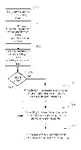
[0041] The method that has been described is summarized in the flowchart
shown in Fig. 5.
In a first step 501, equations of the four bounding lines 301, 302, 303 and
304 (shown in Fig. 4A)
are calculated. Then the intersection point A of the Top and Bottom lines is
found (503), if it exists,
with the existence represented by the Boolean value of the bTopBottom
variable. Similarly, the
intersection point B of the Right and Left lines is found (505), if it exists,
with the existence
represented by the Boolean value of the bLqftRight variable.
[0042] If the primary lines are parallel (506), then the test of
intersection of the primary
lines is bypassed. If bTopBottom is true and if the intersection point A is
inside the Left and Right
lines, then the corner points lying on the Top or Bottom lines respectively
(otherwise referred to
herein as the "Top" points and the "Bottom" points) are swapped (507). Mutatis
mutandis, if the
intersection point B is inside the Top and Bottom lines, then the corner
points lying on the Left or
Right lines respectively (otherwise referred to herein as the "Leff' points
and the "Right.' points) are
swapped (509). Once the corner point indices have been rectified, the
corresponding bounded
images are fit (511) into an Earth surface tiling, using standard processing
methods.
[0043] The remaining question is the determination of which points to swap.
The selection
is a matter of design choice. Typically, any swapping error is consistent over
a range of values of
viewing parameters.
[0044] Using an arbitrary point swap selection, along with the slope
intersection method
described above, may advantageously minimize calculations and the time
required to swap the
points and it has an inherent built-in check to see whether the bowtie of Fig.
4B exists. To particular
advantage, methods in accordance with the present invention are implemented
without calling
trigonometric functions. This feature provides an unexpected advantage over
any other known
methods of detecting and rectifying quadrilaterally bounded images within a
data stream of motion
imagery.
9
CA 03051116 2019-07-22
WO 2018/175165 PCT/US2018/022302
[0045] Application of embodiments of the present invention in particular
illustrative cases
of initial vertex orderings is now described with reference to Figs. 6A-6C. In
Fig. 6A, top line EF
and bottom line GH intersect in a point A outside quadrilateral EFGH, the
Remainder of which
with respect to line EH is positive (it lies above line EH, but the slope of
line EH is negative, so the
Signed Remainder of the intersection A of lines line EF and line GH with
respect to line EH is
negative. Similarly, the Remainder of the intersection of lines EF and line GH
with respect to line
FG is negative (it lies below line FG ). The slope of line PG is positive,
thus the Signed Remainder
of the intersection of lines line EF and line GH with respect to line PG is
also negative. Since the
Signed Remainders of the intersection A of lines of lines EF and line GH with
respect to both of the
secondary lines EH and line PG are negative, the intersection A lies outside
quadrilateral EFGH
and no swapping of indices is called for the primary lines. Similar
considerations confirm that no
swapping of indices is called for in the case of the secondary lines
[0046] Analogous analyses, based on the method described herein, leads to
the conclusion
that quadrilateral KLMN shown in Fig. 6B and quadrilateral PQRS shown in Fig.
6C are bowties,
and that vertices must be swapped, as called for by embodiments of the present
invention.
[0047] The above described methods may be performed, and the above
described systems
may be implemented, by a computer system, including a processor, by executing
appropriate
instructions stored in a memory. A computer program product for rectifying
images has been
described with reference to a processor controlled by instructions stored in a
memory. The memory
may be random access memory (RAM), read-only memory (ROM), flash memory or any
other
memory, or combination thereof, suitable for storing control software or other
instructions and data.
Some of the functions performed by the transformation methods and apparatus
have been described
with reference to flowcharts and/or block diagrams. Those skilled in the art
should readily
appreciate that functions, operations, decisions, etc. of all or a portion of
each block, or a
combination of blocks, of the flowcharts or block diagrams may be implemented
as computer
program instructions, software, hardware, firmware or combinations thereof
Those skilled in the art
should also readily appreciate that instructions or programs defining the
functions of the present
invention may be delivered to a processor in many forms, including, but not
limited to, information
permanently stored on tangible non-transitory non-writable storage media (e.g.
read-only memory
devices within a computer, such as ROM, or devices readable by a computer I/O
attachment, such
CA 03051116 2019-07-22
WO 2018/175165 PCT/US2018/022302
as CD-ROM or DVD disks), information alterably stored on tangible non-
transitory writable storage
media (e.g. floppy disks, removable flash memory and hard drives) or
information conveyed to a
computer through communication media, including wired or wireless computer
networks. In
addition, while the invention may be embodied in software, the functions
necessary to implement
the invention may optionally or alternatively be embodied in part or in whole
using firmware and/or
hardware components, such as combinatorial logic, Application Specific
Integrated Circuits
(ASICs), Field-Programmable Gate Arrays (FPGAs) or other hardware or some
combination of
hardware, software and/or firmware components.
[0048] While the invention is described through the above-described
exemplary
embodiments, it will be understood by those of ordinary skill in the art that
modifications to, and
variations of, the illustrated embodiments may be made without departing from
the inventive
concepts disclosed herein. For example, although some aspects of the shadow
estimation method
have been described with reference to a flowchart, those skilled in the art
should readily appreciate
that functions, operations, decisions, etc. of all or a portion of each block,
or a combination of
blocks, of the flowchart may be combined, separated into separate operations
or performed in other
orders. Moreover, while the embodiments are described in connection with
various illustrative data
structures, one skilled in the art will recognize that the system may be
embodied using a variety of
data structures. Furthermore, disclosed aspects, or portions of these aspects,
may be combined in
ways not listed above. Accordingly, the invention should not be viewed as
being limited to the
disclosed embodiments.
[0049] An example of computer code that may be used to practice the
computer-
implemented method described herein is now provided.
2017 Intergraph Corporation
void CKLVParser0601::FixBowTie(double *pdGroundCorner1Lat, double
*pdGroundCorner1Long,
double *pdGroundCorner2Lat, double *pdGroundCorner2Long,
double *pdGroundCorner3Lat, double *pdGroundCorner3Long,
double *pdGroundCorner4Lat, double *pdGroundComer4Long,
bool bSwapRight, bool bSwapBottom)
if (sNAN == *pdGroundCorner 1 Lat sNAN == *pdGroundCorner1Long
sNAN == *pdGroundCorner2Lat sNAN == *pdGroundCorner2Long
11
CA 03051116 2019-07-22
WO 2018/175165 PCT/US2018/022302
sNAN = *pdGroundCorner3Lat sNAN == *pd(roundCorner3Long
sNAN = *pdGroundCorner4Lat sNAN == *pdGroundCorner4Long)
return;
// treat the lat long as points in a cartesian x,y graph
// Determine the equation of the four line
bool bABIntersect = false;
bool bSwapped = false;
// Line A from point 1 to point 2
double dASlope = 0;
double dASlopeSign = 1.0;
double dAIntercept = 0;
double dARun = *pdGroundComer2Long - *pdGroundCorner1Long;
double dARise = *pdGroundComer2Lat - *pdGroundComerl Lat;
if (dARun != 0)
dASlope = dARise / dARun;
if (dASlope < 0)
dASlopeSign = -I 0;
dAIntercept = *pdGroundCorner1Lat - dASlope * *pdGroundComer1Long;
else
// A vertical line
// Slope is infinite
// Intercept is all vertical point at point x(lLong)
// Line B from point 4 to point 3
double dYABIntersect = 0,
double dXABIntersect = 0,
double dBSlope = 0;
double dBSlopeSign = 1.0;
double dBIntercept = 0;
double dBRun = *pdGroundCorner4Long - *pdGroundCorner3Long;
double dBRise = *pdGroundComer4Lat - *pdGroundCorner3Lat;
if (dBRun != 0)
dBSlope = dBRise / dBRun;
if (dB Slope < 0)
dBSlopeSign = -1.0;
12
CA 03051116 2019-07-22
WO 2018/175165 PCT/US2018/022302
dBIntercept = *pdGroundCorner3Lat - dBSlope * *pdGroundComer3Long;
else
// A vertical line
// Slope is infinite
// Intercept is all vertical point at point x(lLong)
1
// See if the opposite lines intersect
if (dBRun != 0 && dARun != 0)
// General case
if (dBSlope != dASlope)
// They must intersect
dXABIntersect = (dBIntercept - dAIntercept) / (dASlope - dBSlope);
dYABIntersect = dASlope * ((dBIntercept - dAIntercept) / (dASlope -
dBSlope)) + dAIntercept;
bABIntersect = true;
// Othewise they are coincident or parallel and do not intersect
else if (0 == dBRun && 0 == dARun)
// Both are vertical and are either coincident or do not itersect
// Do nothing
else if (0 == dBRun && 0 != dARun)
II B id vertical and A sloped
// B is the Long value or X
dXABIntersect = *pdGroundComer3Long,
dYABIntersect = dASlope * dXABIntersect + dAIntercept;
bABIntersect = true;
else
// A is vertical and B sloped
// A is the Long value or X
dXABIntersect = *pdGroundComerl Long;
dYABIntersect = dBSlope * dXABIntersect + dBIntercept;
bABIntersect = true;
1
13
CA 03051116 2019-07-22
WO 2018/175165
PCT/US2018/022302
// Second set of lines
bool bCDIntersect = false;
// Line C from point 2 to point 3
double dCSlope = 0,
double dCSlopeSign = 1.0;
double dCIntercept = 0;
double dCRun = *pdGroundCorner3Long - *pdGroundCorner2Long,
double dCRise = *pdGroundCorner3Lat - *pdGroundCorner2Lat;
if (dCRun != 0)
dCSlope = dCRise / dCRun;
if (dCSlope < 0)
dCSlopeSign = -1.0;
dCIntercept = *pdGroundCorner2Lat - dCSlope * *pdGroundComer2Long;
// Else it is a vertical line
// Slope is infinite
// Intercept is all vertical point at point x(lLong)
// Line D from point 4 to point 1
double dYCDIntersect = 0;
double dXCDIntersect = 0;
double dDSlope = 0;
double dDSlopeSign = 1.0;
double dDIntercept = 0;
double dDRun = *pdGroundComer4Long - *pdGroundCorner1Long;
double dDRise = *pdGroundComer4Lat - *pdGroundCorner1Lat;
if (dDRun != 0)
dDSlope = dDRise / dDRun;
if (dDSlope < 0)
dDSlopeSign = -1.0;
dDIntercept = *pdGroundCorner4Lat - dDSlope * *pdGroundCorner4Long;
1
// Else it is a vertical line
// Slope is infinite
// Intercept is all vertical point at point x(lLong)
// See if the opposite lines intersect
if (dDRun I= 0 && dCRun != 0)
14
CA 03051116 2019-07-22
WO 2018/175165 PCT/US2018/022302
// General case
if (dDSlope != dCSlope)
// They must intersect
dXCDIntersect = (dDIntercept - dCIntercept) / (dCSlope - dDSlope);
dYCDIntersect = dCSlope * ((dDIntercept - dCIntercept) / (dCSlope -
dDSlope)) + dCIntercept,
bCDIntersect = true;
// Othewise they are coincident or parallel and do not intersect
else if (0 == dDRun && 0 == dCRun)
// Both are vertical and are either coincident or do not itersect
// Do nothing
else if (0 == dDRun && 0 dCRun)
1
// D is vertical and C sloped
// D is the Long value or X
dXCDIntersect = *pdGroundComer4Long;
dYCDIntersect = dCSlope * dXCDIntersect + dCIntercept;
bCDIntersect = true;
else
II C is vertical and D sloped
// C is the Long value or X
dXCDIntersect = *pdGroundComer2Long;
dYCDIntersect = dDSlope * dXCDIntersect + dDIntercept;
bCDIntersect = true;
1
// Determine if the intersect point is inside the bounding rectangle. If so it
is a bowtie
if (bABIntersect)
// see if it is between lines C and D
double dYC = (dCSlope * dXABIntersect + dCIntercept - dYABIntersect) *
dCSlopeSign;
double dYD = (dDSlope * dXABIntersect + dDIntercept - dYABIntersect) *
dDSlopeSign;
// If they have opposite signs, it is a bowtie
if ((dYC >= 0 && dYD <=0) 11 (dYC <=0 && dYD >= 0))
// Swap points 2 and 3 or you could do 1 and 4
CA 03051116 2019-07-22
WO 2018/175165 PCT/US2018/022302
if (b SwapRight)
double dLatTemp = *pdGroundCorner2Lat;
double dLongTemp = *pdGroundCorner2Long;
*pdGroundCorner2Lat = *pdGroundCorner3Lat;
*pdGroundCorner2Long = *pdGroundCorner3Long;
*pdGroundCorner3Lat = dLatTemp,
*pdGroundCorner3Long = dLongTemp;
else
double dLatTemp = *pdGroundCorner4Lat;
double dLongTemp = *pdGroundCorner4Long,
*pdGroundCorner4Lat = *pdGroundCorner1Lat;
*pdGroundCorner4Long = *pdGroundCornerl Long;
*pdGroundCorner1Lat = dLatTemp;
*pdGroundCorner1Long = dLongTemp;
1
dBSlope = 0,
dBSlopeSign = 1.0;
dBIntercept = 0;
dBRun = *pdGroundCorner4Long - *pdGroundComer3Long;
dBRise = *pdGroundCorner4Lat - *pdGroundComer3Lat;
if (dBRun != 0)
dBSlope = dBRise / dBRun;
if (dBSlope < 0)
dBSlopeSign = -1.0;
dBIntercept = *pdGroundCorner3Lat - dBSlope
*pdGroundCorner3Long;
else
// A vertical line
// Slope is infinite
// Intercept is all vertical point at point x(lLong)
if (bCDIntersect && !b Swapped)
// see if it is between lines A and B
16
CA 03051116 2019-07-22
WO 2018/175165 PCT/US2018/022302
double dYA = (dASlope * dXCDIntersect + dAIntercept - dYCDIntersect) *
dASlopeSign;
double dYB = (dBSlope * dXCDIntersect + dBIntercept - dYCDIntersect) *
dBSlopeSign;
// If they have opposite signs, it is a bowtie
if ((dYA >= 0 && dYB <= 0) 11 (cIYA <= 0 && dYB >= 0))
// Swap points 3 and 4 or you could do 1 and 2
if (bSwapBottom)
b Swapped = true;
double dLatTemp = *pdGroundComer3Lat;
double dLongTemp = *pdGroundCorner3Long,
*pdGroundCorner3Lat = *pdGroundCorner4Lat;
*pdGroundCorner3Long = *pdGroundComer4Long;
*pdGroundCorner4Lat = dLatTemp;
*pdGroundCorner4Long = dLongTemp;
1
else
double dLatTemp = *pdGroundComer1Lat;
double dLongTemp = *pdGroundCorner1Long;
*pdGroundCorner 1Lat = *pdGroundCorner2Lat;
*pdGroundCorner1Long = *pdGroundComer2Long;
*pdGroundCorner2Lat = dLatTemp;
*pdGroundCorner2Long = dLongTemp;
1
1
1
17