Note: Descriptions are shown in the official language in which they were submitted.
CA 03054590 2019-08-26
WO 2017/173535 PCT/CA2017/050411
AUTOMATIC PRESSURE SENSOR OUTPUT CALIBRATION FOR RELIABLE
ALTITUDE DETERMINATION
Technical Field
[0001]The present disclosure relates to absolute altitude determination of
electronic
devices using on board atmospheric pressure sensors.
Background
[0002] Positioning of electronic devices is achieved using one or more of:
GNSS
satellites, Wi-Fi access points and cellular base stations, for example.
Although it is
possible to position electronic devices outdoors in three dimensions using
GNSS, indoor
positioning in three dimensions presents challenges.
[0003]Altitude may be determined by atmospheric pressure sensors of the
electronic
devices. Altitudes are calculated based on differences between atmospheric
pressure
sensor output and pressure at mean seal level. Because the atmospheric
pressure
sensors of electronic devices are often uncalibrated, large deviations in
determined
altitudes may occur. For example, different electronic devices that include
similar
hardware may generate altitudes that are 12 metres off from one another.
[0004] In order to avoid errors that may arise due to uncalibrated atmospheric
pressure
sensors, some electronic devices calculate relative altitudes, which are
differences in
altitude over a selected time period or distance. Because a starting location
is relied
upon, relative altitude determination has limited applications. For example,
relative
altitude determination may be used to determine if the user transporting the
electronic
device is moving up or down but will not be able to determine the user's floor
in a multi-
storey building unless a starting floor is input for reference.
[0005] Manual calibration of atmospheric pressure sensors by electronic device
manufacturers may lengthen production time and delay delivery of electronic
devices,
which is undesirable. Manual calibration by electronic device users is
inconvenient and
may be viewed as an annoyance, particularly if use of the electronic device is
restricted
until the calibration is performed.
1
CA 03054590 2019-08-26
WO 2017/173535 PCT/CA2017/050411
Summary
[0006] According to an aspect of the present disclosure there is provided a
method of
calibrating output of an absolute atmospheric pressure sensor of an electronic
device,
comprising: determining, at a processor of the electronic device, that a
location of the
electronic device is at a known absolute altitude and outdoors; receiving, at
the
processor, a measured pressure from the absolute atmospheric pressure sensor;
calculating, at the processor, a difference between the measured pressure and
a
reference pressure, the reference pressure determined by adjusting a mean sea
level
pressure based on the known absolute altitude relative to mean sea level at
the location
of the electronic device; storing the difference, in a memory of the
electronic device; and
applying the difference to the output of the absolute atmospheric pressure
sensor;
wherein determination that the electronic device is at the known absolute
altitude and
outdoors occurs without user input.
[0007] According to another aspect of the present disclosure there is provided
an
electronic device comprising: an absolute atmospheric pressure sensor for
generating
output indicative of an absolute altitude of the electronic device; and a
processor in
communication with a motion sensor and a GNSS sub-system to determine that a
location of the electronic device is at a known absolute altitude and
outdoors, the
processor: receiving a measured pressure from the absolute atmospheric
pressure
sensor, calculating a difference between the measured pressure and a reference
pressure, storing the difference in the memory of the electronic device in
communication
with the processor and applying the difference to the output of the absolute
atmospheric
pressure sensor, the reference pressure determined by adjusting a mean sea
level
pressure based on the known absolute altitude relative to mean sea level at
the location
of the electronic device.
[0008] According to still another aspect of the present disclosure there is
provided a
method of calibrating output of an absolute atmospheric pressure sensor of an
electronic device, comprising: determining, at a processor of the electronic
device, that
a location of the electronic device is at ground level when a first criterion
and a second
criterion are met for a threshold period of time; receiving, at the processor,
a measured
pressure from the absolute atmospheric pressure sensor; calculating, at the
processor,
2
CA 03054590 2019-08-26
WO 2017/173535 PCT/CA2017/050411
a difference between the measured pressure and a reference pressure, the
reference
pressure determined by adjusting a mean sea level pressure based on a altitude
of
ground level relative to mean sea level at the location of the electronic
device; storing
the difference, in a memory of the electronic device; and applying the
difference to the
output of the absolute atmospheric pressure sensor.
[0009] According to another aspect of the present disclosure there is provided
an
electronic device comprising: an absolute atmospheric pressure sensor for
generating
output indicative of an absolute altitude of the electronic device; and a
processor in
communication with a motion sensor and a GNSS sub-system to determine that a
location of the electronic device is at ground level when a first criterion
and a second
criterion are met for a threshold period of time, following determination that
the location
of the electronic device is at ground level, the processor: receiving a
measured pressure
from the absolute level pressure and a reference pressure, storing the
difference in the
memory of the electronic device in communication with the processor and
applying the
difference to the output of the absolute atmospheric pressure sensor, the
reference
pressure determined by adjusting a mean sea level pressure based on a altitude
of
ground level relative to mean sea level at the location of the electronic
device.
Drawings
[0010] The following figures set forth examples in which like reference
numerals denote
like parts. The present disclosure is not limited to the examples illustrated
in the
accompanying figures.
[0011] FIG. 1 is a block diagram of an electronic device operable to implement
atmospheric pressure sensor calibration methods described herein.
[0012] FIG. 2 is a flowchart depicting a method of calibrating an atmospheric
pressure
sensor according to an example.
[0013] FIG. 3 is a graph depicting an example motion sensor output pattern of
the
electronic device of FIG. 1.
[0014] FIG. 4 is a graph depicting example Signal-to-Noise Ratio (SNR) of GNSS
signals received at the electronic device of FIG. 1.
3
CA 03054590 2019-08-26
WO 2017/173535 PCT/CA2017/050411
[0015]FIG. 5 is a flowchart depicting a method of determining that a user is
at ground
level and outdoors according to an example.
[0016]FIGS. 6 and 7 are schematic diagrams showing a user transporting an
electronic
device located at ground level and in a building, respectively.
Detailed Description
[0017] It will be appreciated that for simplicity and clarity of illustration,
where
considered appropriate, reference numerals may be repeated among the figures
to
indicate corresponding or analogous elements. In addition, numerous specific
details
are set forth in order to provide a thorough understanding of the examples
described
herein. However, it will be understood by those of ordinary skill in the art
that the
examples described herein may be practiced without these specific details.
Unless
explicitly stated, the methods described herein are not constrained to a
particular order or
sequence. Additionally, some of the described methods or elements thereof can
occur or
be performed at the same point in time. In other instances, well-known
methods,
procedures and components have not been described in detail so as not to
obscure the
examples described herein. Also, the description is not to be considered as
limiting the
scope of the examples described herein.
[0018]Referring to Figure 1, an example electronic device 10 includes a main
processor
sub-system 16 that controls overall operation of thereof. The main processor
sub-
system 16 includes a processor 18, a memory 20 and a communication interface
22.
An example of a main processor sub-system 16 is a Single Board Computer (SBC)
with
an Operating System (OS).
[0019]The communication interface 22 enables communication with a server 30
via a
wireless or a wired connection. The server 30 may be a single server or a
group of
servers in communication with one another. The electronic device 10 may
additionally
or alternatively communicate directly with another electronic device. In an
example, the
electronic device 10 communicates with a navigation system of a vehicle via
the
communication interface 22.
[0020]The electronic device 10 includes a GNSS antenna 28 for receiving GNSS
signals and a GNSS sub-system 12 in communication with the main processor sub-
4
CA 03054590 2019-08-26
WO 2017/173535 PCT/CA2017/050411
system 16 and the GNSS antenna 28. The GNSS sub-system 12 generates digitized
GNSS data corresponding to the GNSS signals for further processing by the main
processor sub-system 16. Examples of a GNSS sub-system 12 include: a
standalone
GNSS receiver capable of generating a location estimate locally, an Assisted
GNSS (A-
GNSS) receiver that receives assistance data from another device to provide a
location
estimate, a Radio Frequency (RF) Front End (FE) in association with a Software
Defined Radio (SDR) receiver at the electronic device 10 or distributed over
one or
more servers 30.
[0021 ] An atmospheric pressure sensor 24 is in communication with the main
processor
sub-system 16 to send atmospheric pressure sensor output thereto. The
atmospheric
pressure sensor 24 may be any sensor that is capable of outputting an
indication of
absolute atmospheric pressure at the location of the electronic device 10.
[0022] A motion sensor(s) 26 is in communication with the main processor sub-
system
16 to send motion sensor(s) output thereto. The motion sensor(s) 26 may be an
accelerometer, a gyroscope, a magnetometer or another type of sensor capable
of
detecting movement of the electronic device 10.
[0023] The electronic device 10 is powered by a power supply 32, which
communicates
with the main processor sub-system 16 via a power interface 14. In an example,
the
power supply 32 is one or more batteries. In another example, the power supply
32 is a
power supply of a vehicle in which the electronic device 10 is installed.
[0024] The electronic device 10 may be a Smartphone, tablet, portable
computer, laptop
computer, activity tracking device, beacon, router, Machine-to-machine (M2M)
device or
an in-vehicle navigation system, for example. The electronic device 10
includes an
output device 34 to indicate an absolute altitude of the electronic device 10
to a user.
The absolute altitude that is output may be a distance above or below ground
level or a
floor number when the user transporting the electronic device 10 is in a
building, for
example. The output device 34 is in communication with the main processor sub-
system 16 and may be one or more of: a display, a speaker and another output
device,
for example. The electronic device 10 may further include an input device 36
in
communication with the main processor sub-system 16 to receive user input.
CA 03054590 2019-08-26
WO 2017/173535 PCT/CA2017/050411
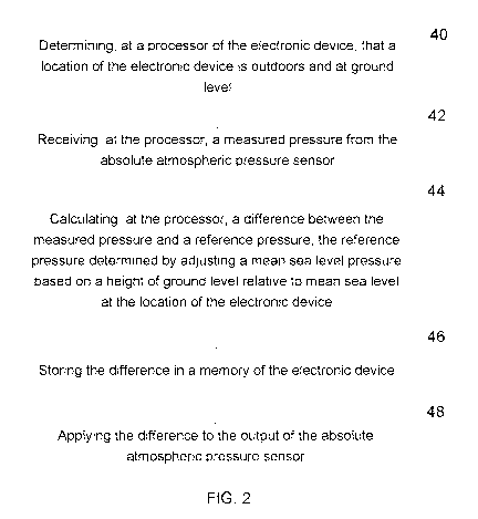
[0025] Referring to FIG. 2, a method of calibrating output of an absolute
atmospheric
pressure sensor of an electronic device includes: determining 40, at a
processor 18,
that a location of the electronic device 10 is at ground level and outdoors,
receiving 42,
at the processor 18, a measured pressure (PsENsoR) from the absolute
atmospheric
pressure sensor 24, calculating 44, at the processor 18, a difference between
the
measured pressure and a reference pressure (PREFERENCE), the reference
pressure
determined by adjusting a mean sea level pressure based on an altitude of
ground level
relative to mean sea level at the location of the electronic device 10,
storing the
difference 46 in a memory 20 of the electronic device 10 and applying 48 the
difference
to the output of the absolute atmospheric pressure sensor 24.
[0026] As will be understood by a person skilled in the art, the difference
may be a
positive value that is added to subsequently measured pressures or a negative
value
that is added to subsequently measured pressures.
[0027] Regularly updated mean sea level pressures are available for many
different
locations around the world from various weather service providers, such as
CustomWeather Inc. and Environment Canada, for example. A frequency of mean
sea
level pressure updates and a granularity of areas over which the mean sea
level
pressures apply may be selected to achieve a desired accuracy and data
transmission
load.
[0028] The altitude of ground level relative to mean sea level varies
depending on where
the electronic device 10 is located in the world. The altitude is determined
based on a
topographic map, which provides altitudes relative to mean sea level at
different
locations in the world. Topographic maps are available from many different
sources,
including government agencies, such as the Centre for Topographic Information
in
Canada, for example. Online topographic information resources are also
available,
including from Google TM maps, for example.
[0029] The mean sea level pressure is adjusted based on the altitude of ground
level to
determine PREFERENCE by way of mathematical methods that are well known by
those
skilled in the art. In an example, the ground level altitude that has been
determined is
further adjusted by 1 metre in order to locate the electronic device at
approximately
pocket level, for example, with respect to the user.
6
CA 03054590 2019-08-26
WO 2017/173535 PCT/CA2017/050411
[0030] The electronic device 10 determines that a user transporting the
electronic
device 10 is at ground level and outdoors, at 40, prior to calculating the
difference, at
44. In an example, user input is relied upon to determine when the electronic
device 10
is located at ground level and outdoors. The user input may be received in
response to
a query generated by the processor 18 or in response to a user selecting an
atmospheric pressure sensor calibration option via a user interface of the
electronic
device 10, for example.
[0031] Other example methods disclosed herein automatically determine that an
electronic device 10 is at ground level and outdoors. The automatic
determination of
outdoor and ground level location may be performed without user input and
without the
user being made aware that the determination is occurring. Electronic device
users
may move into and out of buildings and above and below ground level throughout
the
day. Users that are indoors may be at any altitude relative to ground level.
The same is
true for users that are outdoors. Users with gait-type movement may be
travelling
indoors or outdoors. When users transporting electronic devices 10 travel for
a
relatively long period of time with gait-type movement, it may be determined
that the
users are outdoors and at ground level. The location of the electronic device
may be
determined to be outdoors and at ground level when a first criterion and a
second
criterion are met for a threshold period of time.
[0032] The first criterion is met when output from the motion sensor(s) 26
indicates that
the motion of the user transporting the device corresponds to a selected type
of motion.
The processor 18 determines if the sensor output corresponds to a selected
type of
motion by matching a motion sensor output pattern to known motion sensor
output
patterns. The motion sensor output pattern may correspond to a gait of a user
when the
user transporting the electronic device 10 is walking or running, for example.
Referring
to FIG. 3, an example accelerometer output pattern that corresponds to a
walking gait is
shown. Other known motion sensor output patterns are also possible, such as a
sensor
output pattern corresponding to a user transporting the electronic device 10
in a pocket,
for example, while riding a bike. In general, output from the motion sensor(s)
26 may be
matched to any known motion sensor output pattern from which it is
determinable that
the electronic device 10 is at ground level.
7
CA 03054590 2019-08-26
WO 2017/173535 PCT/CA2017/050411
[0033] The first criterion may alternatively be met when output from the GNSS
sub-
system 12 indicates that the motion of the electronic device 10 corresponds to
a
selected type of motion. In this example, a difference in GNSS location of the
electronic
device 10 over a period of time may be relied upon to indicate movement of the
electronic device 10. Walking may be determined when a speed of approximately
4
km/h is determined. Similarly, when a speed of 30 km/h or greater is
determined, the
electronic device 10 may be determined to be travelling in a vehicle, such as
a car, for
example. Biking or other modes of transportation may be determined when a
speed
indicative of the mode of transportation is determined. In the example in
which the
electronic device 10 communicates with the electronic system of a vehicle, the
first
criterion may also be met when transportation of the electronic device 10 by a
vehicle is
determined based output from an odometer, for example, of the vehicle. Similar
to the
GNSS example, when a speed of 30 km/h or greater is determined, the electronic
device 10 is determined to be travelling in a vehicle.
[0034] The selected types of motion are stored in memory 20 of the main
processor
system 16 and compared to one or more of: motion sensor output, GNSS-based
movement determination and odometer-based movement determination in order to
determine if the first criterion is met. According to an example, confirmation
of the
selected type of motion determined by motion sensor output using GNSS output
may be
performed. In this example, when the sensor output pattern corresponds to a
selected
type of motion over a time period, the GNSS output may be used to confirm that
a
corresponding expected distance has been travelled over the time period. By
confirming the selected type of motion determined by motion sensor output
using GNSS
output, errors due to special cases, such as a user transporting an electronic
device 10
walking around a rooftop track or running on a treadmill, for example, are
avoided.
Other confirmation checks may also be performed.
[0035] The second criterion is met when the Signal-to-Noise ratio (SNR) of
GNSS
signals received at the electronic device 10 is above a threshold. If no GNSS
signals
are received at the electronic device 10, such as when the electronic device
10 is
indoors, for example, the second criterion is not met. In an example, the
threshold is
between 34 and 35 dB. In another example, the threshold is approximately 34
dB.
8
CA 03054590 2019-08-26
WO 2017/173535 PCT/CA2017/050411
Referring to FIG. 4, SNR values of GNSS signals received at the electronic
device are
plotted versus time by way of example.
[0036]An example method of determining that a user transporting an electronic
device
is at ground level and outdoors is shown in FIG. 5. At 50, a timer starts. At
52, data
indicative of electronic device motion, such as motion sensor output, GNSS
location
data or odometer data, for example, is collected and, at 56, SNR data of GNSS
signals
is collected. At 54, the processor 18 of the electronic device 10 determines
if a first
criterion has been met by determining if the data collected corresponds to a
selected
type of motion. If not, the time is re-started at 50 and further motion sensor
data is
collected. At 58, the processor 18 of the electronic device 10 determines if a
second
criterion has been met by determining if the SNR data of GNSS signals received
at the
electronic device 10 is above a threshold. If not, the time is re-started at
50 and further
SNR data of GNSS signals is collected. If both criteria have been met, it is
then
determined whether or not a threshold time period has been exceeded. If yes,
the
electronic device 10 is determined to be at ground level, at 62. If not,
collection of data
indicative of device motion and SNR data of GNSS signals continues at 52 and
56,
respectively.
[0037] The threshold period of time over which the first criterion and second
criterion are
met in order for a determination to be made that the electronic device 10 is
at ground
level is between two and thirty minutes. In an example, the threshold period
of time is
approximately five minutes. Lower or higher threshold periods of time are also
possible.
[0038] According to an example, calibrated absolute atmospheric pressure
sensor
output may be provided with an indication of the error associated therewith.
In this
example, the second criterion and the threshold period of time include error
indications
that may be combined to indicate error of the calibrated atmospheric pressure
sensor
output. For example, SNR below the threshold may be collected in FIG. 5 and
used to
calculate the difference in the method of FIG. 2. The amount that the SNR is
below the
threshold is then used to generate an indication of error. An altitude error
is then
output by the electronic device 10. The error may be increased or decreased
based on
the time over which the first and second criteria were met. As will be
understood by a
person skilled in the art, if the time greatly exceeds the threshold period of
time, the
9
CA 03054590 2019-08-26
WO 2017/173535 PCT/CA2017/050411
output is more reliable. Similarly, if the time is less than the threshold
period of time, the
output is less reliable.
[0039] The method of calibrating an atmospheric pressure sensor disclosed
herein
operates automatically such that a user of the electronic device 10 may not be
aware
that the calibration is underway. The method may run continuously in order to
improve
the reliability of the difference that is calculated. In this example, a
current difference,
which may also be referred to as a current bias, of the atmospheric pressure
sensor that
is stored in memory 20 of the electronic device 10 is replaced when a new
difference is
calculated that has less error associated therewith.
[0040] The method of calibrating an atmospheric pressure sensor may be
performed by
the main processor sub-system 16 of the electronic device 10 by executing one
or more
software applications that are stored in memory 20 as computer readable code.
Alternatively, the method may be performed by dedicated hardware of the main
processor sub-system 16, such as Application Specific Integrated Circuit
(ASIC) or
Graphics Processing Unit (GPU), for example, or by a combination of hardware
and
software. Parts of the method may alternatively be performed at one or more
remote
servers in communication with the electronic device 10.
[0041 ] The method may be performed entirely on the electronic device 10. In
this
example, mean sea level pressures and topographic maps are downloaded to the
electronic device 10 and calculations are performed locally. In another
example, the
mean sea level pressures and topographic maps may alternatively be stored at
the
server 30 and sent to the electronic device 10 in response to requests that
include
locations of the electronic device 10. The method may then be performed
locally.
Alternatively, the method may be performed at the server 30 in response to
requests
from the electronic device 10 that include locations of the electronic device
10 and local
measured ground level pressures output from the absolute atmospheric pressure
sensor.
[0042] The calibrated output from the atmospheric pressure sensor is used to
determine
an altitude of the electronic device 10. FIG. 6 shows a user, who is carrying
an
electronic device 10, at ground level. FIG. 7 shows the user located on the
4th floor of a
building. Because the atmospheric pressure sensor 24 of the electronic device
10
CA 03054590 2019-08-26
WO 2017/173535 PCT/CA2017/050411
carried by the user was calibrated according to the methods disclosed herein,
the
electronic device 10 is able to determine on which floor the user is located
when the
user is in the building. Uncalibrated atmospheric pressure sensors may result
in altitude
determinations that are up to 3 floors away from a user's actual location, as
indicated by
the users carrying electronic devices 10' and 10", which are shown on the 1st
and 7th
floors of the building, respectively.
[0043] In another example, the electronic device 10 automatically determines
that a user
transporting the electronic device 10 is at a known absolute altitude, such as
ground
level, for example, and outdoors in response to occurrence of an event. The
event may
be communication between the electronic device 10 and a beacon of an outdoor
proximity network, for example. In this example, beacons of the proximity
network have
known absolute altitudes and PREFERENCE is determined by adjusting a mean sea
level
pressure based on the absolute altitude relative to mean sea level at the
location of the
electronic device. Communication between a beacon and the electronic device 10
may
occur during a point of sale transaction or when the electronic device 10
receives a
beacon broadcast from a nearby beacon, for example.
[0044] In general, any method that automatically determines that a user
transporting the
electronic device 10 is at a known absolute altitude, such as ground level,
for example,
and outdoors may be used. For example, a precise two-dimensional GPS location
of
the electronic device 10 combined with an accurate map that includes building
structures may be sufficient to provide confirmation that the electronic
device 10 is at a
known absolute altitude and outdoors.
[0045]As will be understood by a person skilled in the art, outdoors may
include
covered outdoor locations, indoor locations adjacent to open windows or other
indoor-
type locations for which the atmospheric pressure sensor is able to indicate
an outdoor
pressure.
[0046]The methods described herein compensate for variability of atmospheric
pressure sensor output of electronic devices 10. By calibrating atmospheric
pressure
sensor output, altitude determinations by the electronic devices are more
likely to be
accurate. Automatic calibration of the atmospheric pressure sensor output is
convenient because calibration occurs without input from the user. Further, it
improves
11
CA 03054590 2019-08-26
WO 2017/173535 PCT/CA2017/050411
the reliability of atmospheric pressure sensor output from the electronic
device 10
because non-calibration due to a user forgetting to initiate the calibration,
for example,
is avoided.
[0047] The methods disclosed herein are globally applicable. The calibration
may be
performed at any location in the world for which current mean sea level
pressure and
topographic map information is available. Further, the altitudes determined
using the
calibrated atmospheric pressure sensor output are absolute altitudes. Thus,
the altitude
determined by the electronic device 10 may be combined with other positioning
systems
to provide locations of the electronic device 10 in three dimensions both
indoors and
outdoors.
[0048] Specific examples have been shown and described herein. However,
modifications and variations may occur to those skilled in the art. All such
modifications
and variations are believed to be within the scope and sphere of the present
disclosure.
12