Note: Descriptions are shown in the official language in which they were submitted.
CA 03056901 2019-09-17
WO 2018/175656
PCT/US2018/023655
CROWDSOURCED MAPPING OF ENVIRONMENTAL HAZARDS
CROSS-REFERENCE TO PRIOR APPLICATIONS
[001] This application claims priority to U.S. Provisional Patent Application
No.
62/474,424, filed on March 21, 2017, which is incorporated by reference herein
in its
entirety.
FIELD
[002] The exemplary embodiments relate generally to the field of real-time
monitoring of
environmental hazards to support industrial safety. More particularly, the
exemplary
embodiments aggregate combined environmental measurement and position data
received
from fixed and / or mobile (e.g., instrumented plant personnel or robots)
electronic
monitoring and positioning devices distributed throughout an industrial
setting to generate an
accurate, real-time visual map of the environmental conditions throughout the
industrial
setting. The embodiments will be described in connection with such utility,
although other
utilities are contemplated.
BACKGROUND
[003] Industrial environments typically include a number of hazards that have
the potential
to cause damage to equipment and to create safety risks. Such hazards may
include, for
example, radiation hazards, chemical hazards, biological hazards, thermal
hazards, audio
hazards, etc. It is highly desirable that measures be taken to reduce or limit
the exposure of
persons, equipment, products and the environment to such hazards in the
industrial settings.
As a result, industrial settings often include precautionary or "safety"
systems that monitor
various environmental factors in an effort to use this environmental
monitoring information
to reduce the risks of equipment damage, product losses, and exposure of
workers to safety
hazards. Such safety systems are typically operated in a "static" manner
meaning that
environmental conditions are measured at discrete locations and times. Due to
inherent
spatial and temporal variability in environmental conditions within typical
industrial settings,
a common shortcoming of such systems is the obsolescence of the collected data
before
strategies can be implemented to optimize worker, equipment, and product
safety in response
to the identified hazards and their location throughout the industrial
setting.
1
CA 03056901 2019-09-17
WO 2018/175656
PCT/US2018/023655
[004] For example, radiological conditions at nuclear facilities, such as dose
rates and
contamination levels, are typically taken at discrete locations and times.
These measurements
are then used to prepare radiological survey maps at discrete times, which are
then used to
plan worker activities to minimize radiological worker exposures until the
next survey is
performed. In the interim time between discrete radiological surveys,
radiological conditions
may change substantially due to changes in equipment operation, water levels
within
components (which provide shielding from radioactivity), maintenance and
inspection
activities such as radiography, and other factors. Therefore, as time passes,
there is
diminishing probability that prior surveys of radiological conditions
accurately reflect the
current conditions, which increases the risk of worker exposure to
unanticipated and
potentially more severe radiological conditions.
[005] For improved planning of work activities and greater assurance that
exposure of
persons, equipment, products and the environment to such hazards will be
minimized, it is
desirable to maintain more accurate and up-to-date data regarding
environmental conditions
and to make this information available to industrial personnel and workers in
a readily
useable form. A need therefore exists for a system and method which provides
accurate, real-
time visual mapping and summary of environmental conditions and hazards
throughout an
industrial setting.
SUMMARY
[006] Aspects of the exemplary embodiments relate to systems and/or methods
for
environmental condition mapping which utilize data from electronic monitoring
and
positioning devices worn by each individual plant worker, integrated into
robots, and/or
located throughout an industrial setting. The combined environmental
measurement and
position data for each worker or device is monitored and recorded as a
function of time as the
plant workers/robots move throughout the industrial setting and the
environmental conditions
change. Geospatial and statistical techniques are then used to aggregate
measurements from
workers/devices and display this data as an accurate, real-time visual map of
environmental
conditions throughout the industrial setting.
[007] The implementations of the exemplary embodiments herein provide
significant
improvement in inputs available for hazard mitigation strategy development. In
particular,
the systems and/or methods of the exemplary embodiments generate high-
fidelity, real-time
2
CA 03056901 2019-09-17
WO 2018/175656
PCT/US2018/023655
visual maps of environmental conditions throughout an industrial setting
utilizing accurate
and up-to-date data regarding one or more environmental factors pertinent to
the industrial
setting. This information can then be used to reduce exposure of persons,
equipment,
products and the environment to the hazards in real-time. As used herein,
environmental
factors include but are not limited to radiation (dose rates, contamination
levels, etc.),
chemical exposure (concentration of noxious gasses, concentration of explosive
gasses, etc.),
airborne particulates, biological exposure (e.g., infectious diseases),
thermal hazards, noise
hazards and the like. In the systems and/or methods of the exemplary
embodiments, the
monitoring and positioning devices, the data from which are used to generate
the
aforementioned real-time hazard maps, may be personal monitoring and
positioning devices
worn by each individual worker and / or may be, integrated within robots and /
or may be
integrated within fixed environmental monitoring stations. As will be
appreciated by those
skilled in the art, a sensor or sensing device may optionally be integrated
with a location
tracking device depending on the environmental hazards that exists in a given
industrial
setting.
[008] In one exemplary embodiment, a method of generating a real-time,
crowdsourced
visual map summarizing measurements reflecting environmental conditions
affecting
personnel safety in an industrial facility or work area is provided. The
method includes
receiving a request for a measurement map from a user, wherein the request
includes an
indication of the floor plan of interest of the facility; retrieving an image
of the floor plan of
interest; receiving measurement data and positional data from one or more
portable
measurement devices in the industrial facility or work area, wherein the
portable
measurement devices are either worn by workers, mounted to robotic platforms,
carried by
workers as hand-held instruments, or mounted to stationary equipment or
structures; spatially
interpolating the received measurement data with the positional data;
overlaying the spatially
interpolated measurement data on the floor plan of interest to generate a
continuously
updated visual map of environmental conditions affecting personnel safety
within the area of
interest; and displaying the visual map to the user.
[009] In another exemplary embodiment, a system for generating a real-time,
crowdsourced
visual map summarizing measurements reflecting environmental conditions
affecting
personnel safety in an industrial facility or work area is provided. The
system including one
or more portable measurement devices which collect environmental hazard and
positional
3
CA 03056901 2019-09-17
WO 2018/175656
PCT/US2018/023655
data, wherein the portable measurement devices are either worn by workers,
mounted to
robotic platforms, carried by workers as hand-held instruments, or mounted to
stationary
equipment or structures. The system also including a computer system that
includes one or
more physical processors programmed with computer program instructions that,
when
executed, cause the computer system to receive a request for a measurement map
from a user,
wherein the request includes an indication of the floor plan of interest of
the facility;
retrieving an image of the floor plan of interest; receiving measurement data
and positional
data from one or more portable measurement devices in the industrial facility
or work area,
wherein the portable measurement devices are either worn by workers, mounted
to robotic
platforms, carried by workers as hand-held instruments, or mounted to
stationary equipment
or structures; spatially interpolate the received measurement data with the
positional data;
overlay the spatially interpolated measurement data on the floor plan of
interest to generate a
continuously updated visual map of environmental conditions affecting
personnel safety
within the area of interest; and display the visual map to the user
[010] Various other aspects, features, and advantages of the exemplary
embodiments will be
apparent through the detailed description of the exemplary embodiments and the
drawings
attached hereto. It is also to be understood that both the foregoing general
description and the
following detailed description are exemplary and not restrictive of the scope
of the exemplary
embodiments. As used in the specification and in the claims, the singular
forms of "a", "an",
and "the" include plural referents unless the context clearly dictates
otherwise. In addition, as
used in the specification and the claims, the term "or" means "and/or" unless
the context
clearly dictates otherwise.
BRIEF DESCRIPTION OF THE DRAWINGS
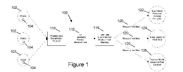
[011] FIGS. 1 and 2 show an exemplary embodiment of an environmental mapping
system
which utilizes data from personal/automated monitoring and positioning
devices, in
accordance with one or more embodiments.
[012] FIGS. 3A-D show an exemplary real-time visual map of environmental
conditions
present in controlled areas within an industrial setting, in accordance with
one or more
embodiments.
[013] FIG. 4 shows a flowchart of a method for spatial interpolation, in
accordance with one
or more embodiments.
4
CA 03056901 2019-09-17
WO 2018/175656
PCT/US2018/023655
[014] FIG. 5 shows a flowchart of a method for generating and displaying a
visual map of
environmental conditions present in controlled areas within an industrial
setting, in
accordance with one or more embodiments.
DETAILED DESCRIPTION OF THE EXEMPLARY EMBODIMENTS
[015] In the following description, for the purposes of explanation, numerous
specific
details are set forth in order to provide a thorough understanding of the
exemplary
embodiments. It will be appreciated, however, by those having skill in the art
that the
exemplary embodiments may be practiced without these specific details or with
an equivalent
arrangement. In other instances, well-known structures and devices are shown
in block
diagram form in order to avoid unnecessarily obscuring the exemplary
embodiments.
[016] Configuration of Environmental Mapping System
[017] Exemplary embodiments of an environmental mapping system 100 which
utilizes data
from electronic monitoring and positioning devices 104 positioned throughout
an industrial
setting are illustrated in FIGS. 1 and 2. Upon entering a controlled area in
an industrial
setting, each worker 102 or robot 103 may carry / convey a monitoring and
positioning
device 104 to monitor their exposure to nearby environmental hazards during
work and non-
work activities. It should be appreciated that during work and non-work
activities, numerous
workers 102 and / or robots 103 may be moving or working within these
controlled areas at
any given time. Environmental measurement data may be obtained using
monitoring and
positioning devices 104 worn by each worker 102 and/or robot 103 and utilized
primarily to
monitor and document the exposure of the monitored individuals 102 / robots
103 to
environmental factors and/or hazards. While moving within the controlled area,
the
monitoring and positioning device 104 for each plant worker 102 / robot 103
may obtain data
associated with the worker's / robot's hazards exposure during work
activities. In some
embodiments, the measurement data for each plant worker 102 / robot 103 is
processed to
determine a corresponding exposure level. In some embodiments, the measurement
data is
post-processed to calculate cumulative exposure of users to one or more
environmental
hazards during normal operation of the industrial facility. In other
embodiments, the
measurement data is post-processed to calculate cumulative exposure of users
to one or more
environmental hazards following an industrial safety event. In some
embodiments,
CA 03056901 2019-09-17
WO 2018/175656
PCT/US2018/023655
individual users are notified via one or more portable measurement devices of
their
cumulative exposure level approaching or exceeding a pre-determined threshold.
[018] With reference to FIG. 2, each monitoring and positioning device 104 may
include an
electronic positioning device 106 and an environmental monitoring device 108
that is worn
by the plant worker while working in a controlled area. For example, the
monitoring and
positioning device 104 may be an electronic personal measurement device
(handheld or
worn) used by individual workers 102. In some embodiments, the electronic
personal
measurement device may include an integral or attached location tag and a
button to log a
measurement. In another example, the monitoring and positioning device 104 may
be a robot
103 which incorporates a measurement and positioning device 104 to provide
better coverage
in areas with dangerous exposure levels. It should be appreciated that such a
robot may
consist of, but would not be limited to, land-based unmanned vehicles and
unmanned drones
such as UAVs that are able to reach difficult locations and may be autonomous,
semi-
autonomous, or remotely operated. It should also be appreciated that the
monitoring and
positioning device 104 may either be two separate devices (an electronic
monitoring device
and position monitoring device) or a single device (a combined electronic
monitoring and
position device) that monitors both environmental factors and position. In
some
embodiments, the monitoring and positioning device 104 is configured to
acquire
environmental measurements in a continuous, periodic, or automated manner.
[019] In some embodiments, the monitoring and positioning device 104 may
monitor
different types of environmental factors including but not limited to
radiation factors (dose
rates, contamination levels, etc.), chemical exposure factors (corrosive
liquids, noxious or
explosive gasses, etc.), airborne particulates, biological factors (e.g.,
infectious diseases),
temperature, noise, or a combination thereof Personal positioning may be
monitored, for
example, using radio frequency time-of-flight triangulation techniques using a
plurality of
positioning beacons placed near or within the controlled area and a
specialized transceiver
worn by the plant worker 102 or integrated into the robot 103. The location
and number of
positioning beacons may be optimized to achieve the desired level of accuracy
and precision.
Inertial measurements may also be used along with trilateration between
transceivers worn by
plant workers 102 / robots 103 and positioning beacons in order to enhance the
precision of
position data. In some embodiments, the monitoring and positioning device 104
may utilize
the global positioning system (GPS), ultra wideband indoor positioning (UWB),
beacon
6
CA 03056901 2019-09-17
WO 2018/175656
PCT/US2018/023655
indoor positioning system (BLE), inertial measurement units (IMU), RFID, or
other
positioning methods to provide the position data for each worker 102 / robot
103.
[020] With continuing reference to FIG. 1, the environmental measurement and
position
data for each plant worker 102 / robot 103 may be preferably transmitted to
central data
storage media located in one or more servers, in real-time using an
appropriate wireless data
communications system 110 such as, for example, Wi-Fi, 4G, or other protocol
that provides
continuous or nearly continuous connectivity throughout the facility.
Alternatively,
asynchronous data transmission may be used in cases where connectivity to a
data network is
not available throughout the facility. For example, environmental measurement
and position
data as a function of time may be transmitted to a central data storage medium
using a near-
field communications protocol such as Bluetooth or RFID when the plant worker
102 / robot
103 logs out of the controlled area or when the plant worker 102 / robot 103
reaches an area
in which connectivity to an appropriate wireless data network is available.
Regardless of
whether real-time or asynchronous data transmission is used, the monitoring
and positioning
device(s) 104 may have internal storage to ensure data is retained when data
transmission
protocols are unavailable.
[021] In some embodiments, the environmental measurement and position data may
be
standardized 112 to include the worker/robot ID, timestamp, position data,
measurement data,
and the like. For example, environmental measurement and position data may be
associated
with a specific plant worker's identity such as the worker's badge number,
passive
measurement device number or other identifier to facilitate additional real-
time or post-
processing diagnostics, if desired. In some embodiments, such identity
associations may be
optionally anonymized for specific individuals, as appropriate, or access to
the location and
identity of specific individuals within the plant may be limited by software
security settings.
Alternatively, selected plant workers, such as security personnel, may not
wear location
monitoring devices of the type described herein for facility security reasons.
In some
embodiment, the environmental measurement and position data may be provided
with a
timestamp. For example, the monitoring and positioning device 104 may obtain
the
environmental measurement and position data as a function of time by which the
timestamp
is generated.
[022] In some embodiments, the environmental measurement and position data may
be
transmitted to and stored in a measurement data collection server 114 and a
positioning data
7
CA 03056901 2019-09-17
WO 2018/175656
PCT/US2018/023655
collection server 116. It should be appreciated that the data collection
servers 114, 116 may
either be two separate servers (a measurement data collection server 114 and a
positioning
data collection server 116) or a single data collection server which may store
the
environmental measurement and position data as a function of time.
[023] Once environmental measurement and position data as a function of time
are available
on the data collection server, analysis software residing in an environmental
condition
mapping server 118 may be utilized to analyze and aggregate data from all
monitoring and
positioning devices 104 using statistical techniques, and display the data as
real-time visual
maps 120 of current environmental conditions present in controlled areas
within the industrial
setting. In some embodiments, the visual maps 120 are generated updated in a
continuous or
periodic manner. In some embodiment, the environmental condition mapping
server 118
may create visual maps of historical environmental conditions in controlled
areas within the
industrial setting. The magnitude of environmental factors, time that has
passed since these
measurements were obtained, and other factors may be considered in the
analysis and display
routines to ensure that these visual maps are useful for planning and work
activity controls.
The analysis software may utilize a regression model, such as a Kriging model,
that considers
uncertainties associated with individual environmental and position
measurements and/or
variations due to time to create a visual map of environmental conditions that
includes
inferred predictions for locations with no measurement data. For example, the
analysis
software may determine the locations with hazardous exposure levels, based on
pre-
determined thresholds for the metric being measured (e.g., radiation dose
rate, flammable gas
concentration, etc.), and plan work activities around these areas until a
safer exposure level
exists. It should be appreciated that the environmental condition mapping
server 118 may be
located within the industrial setting, at a central location, or in a cloud
remote infrastructure.
[024] In some embodiment, the environmental condition mapping server 118 may
identify
one or more areas of the industrial setting which have abnormal environmental
conditions.
For example, the environmental condition mapping server 118 may calculate the
difference
between values (e.g., radiation dose rates) in the most recent spatially
interpolated map of
measurement data and those in prior spatially interpolated maps of measurement
data. Based
on the results of the calculation, an area having abnormal environmental
conditions may be
identified. In response to an abnormal environmental conditions being
identified, the
environmental condition mapping server 118 may add an indication of the
abnormal
8
CA 03056901 2019-09-17
WO 2018/175656
PCT/US2018/023655
environmental conditions as an overlay to the existing visual map displayed to
the worker.
As stated earlier, a particular area may be determined to have hazardous
environmental
conditions irrespective of the difference between current and prior
measurements based on
pre-determined thresholds for the metric being measured (e.g., radiation dose
levels,
flammable gas concentration, etc.). However, a rapid jump in any metric could
suggest the
possibility of a new hazard, bad data, or insufficient data (i.e., the
interpolation scheme
uncertainty has significantly increased in that region), etc. all of which
could impact worker
safety and thus should be accounted for in work planning and optionally
displayed on the
visual map as stated above.
[025] In some embodiments, the environmental condition mapping server 118 may
be able
to predict or infer the environmental conditions or exposure levels based on
the spatially
interpolated measurement data. For example, in cases where workers are
carrying location
monitoring equipment but no supplemental environmental condition monitoring
devices,
position measurements for a given worker are used to look up inferred
environmental
exposure values predicted by the spatially interpolated measurement data. The
inferred
environmental exposure values may be based on interpolated data which was
previously
generated by workers / robots that had both environmental condition monitoring
devices and
position measurement devices. This inference of environmental exposure based
on
interpolation of pre-existing data could be used as part of normal operation
of the industrial
facility but would be considered particularly useful following an industrial
safety event (e.g.,
seismic event) given the increased number of workers present in such
scenarios, some of
whom may only be wearing positional monitors (i.e., without accompanying
hazard
monitors), given the nature of the work to be performed.
[026] In some embodiments, the environmental exposure data associated with any
given
worker 102 / robot 103, either directly measured from the environmental
condition
monitoring devices worn by said worker 102 / robot 103 or inferred based on
the known
positional information of said worker 102 / robot 103 relative to pre-existing
spatially
interpolated environmental hazard data, is post-processed (i.e., integrated
over time) to
calculate the cumulative exposure of the worker 102 / robot 103 to the
environmental hazard.
For example, instantaneous and cumulative environmental exposure levels are
estimated for
the one or more users utilizing portable positional measurement devices
without
environmental measurement functionality based on pre-existing spatially
interpolated
9
CA 03056901 2019-09-17
WO 2018/175656
PCT/US2018/023655
measurement data. In some embodiment, the estimation of instantaneous and
cumulative
environmental exposure levels is implemented during normal operation of the
industrial
facility. In other
embodiments, the estimation of instantaneous and cumulative
environmental exposure levels is implemented following an industrial safety
event. Based on
calculated level of cumulative exposure, the worker may be notified if their
exposure level
exceeds a given threshold value.
[027] In some embodiments, the real-time visual map of environmental
conditions present
in controlled areas of an industrial setting may include a building layout or
blueprints
documenting the architecture of the industrial setting. The visual map may
indicate the
magnitude of exposure levels of the environmental factors for particular
regions of the
industrial setting. It should be appreciated that the visual map may be
overlaid onto a 2D
floor plan or projected onto the surface of a 3D model of the area (e.g.,
LIDAR point cloud)
for ease of indicating environmental hazards to the workers.
[028] It should be appreciated that the visual maps generated by the
environmental
condition mapping server 118 may be displayed to workers and other users via
the
monitoring and positioning device 104, a handheld device such as a mobile
phone or tablet
device, a central monitoring station, etc. In some embodiments, the monitoring
and
positioning device 104 may be location-aware and leveraged to alerting the
worker to his /
her current location to proactively limit the number of entries and / or time
spent within in an
area with an elevated hazard level based on the results of the calculations
performed by the
environmental condition mapping server 118. In another embodiment, the
environmental
condition mapping server 118 may notify the population of workers via their
monitoring and
positioning device 104 of an industrial safety hazard (e.g., by audible,
visual, vibration alarm)
when they are inside or near an area that is predicted, based on the spatially
interpolated
measurement data, to exceed a given threshold value.
[029] With continuing reference to FIG. 1, the analysis software may also
include visual
and audible cues to alert plant workers to changing environmental conditions,
assist in
detecting and screening anomalous data, and to help identify individual
workers that are
approaching their environmental hazard alarm limits so that these workers can
be located and
instructed to leave the controlled area before limits are exceeded. For
example, the software
may provide the visual and audible cues to a plant worker's monitoring and
positioning
device 104 or to work safety personnel to assist them in locating and
instructing the worker to
CA 03056901 2019-09-17
WO 2018/175656
PCT/US2018/023655
leave the controlled area. In another example, the software may provide the
visual and
audible cues to various locations throughout the plant such as a work safety
control station
122, a dashboard display within the controlled area 124, a personal display
device 126 at a
work location, and the like. The analysis software may also include
diagnostics for
quantifying changes in environmental conditions associated with specific plant
events. In the
context of radiation hazards in a nuclear power plant, such events would
include but not be
limited to draining water from a vessel/component, starting a pump, performing
radiography
or other maintenance/inspection activities. These diagnostic tools may also be
used for post-
processing, improved root cause evaluations following elevated worker exposure
events, and
planning of future work activities similar to those for which data has been
acquired (e.g.,
establish locations with most exposure during a first evolution and develop
work plans to
avoid these high exposure areas in future similar evolutions).
[030] In other embodiments, the visual maps 120 may be displayed at facility
checkpoints to
assist work safety personnel in briefing workers prior to work activities. The
visual maps 120
may also be displayed on personal devices or in common areas within controlled
areas to
provide visual aids directly to plant workers during work activities. The
software may
facilitate display of environmental conditions within a single controlled area
or may scroll
between multiple controlled areas within the industrial setting. It should be
appreciated that
because numerous plant workers are contributing data to these visual maps
simply by
wearing common monitoring devices during their normal work activities, the
resolution and
confidence level associated with environmental conditions throughout the
industrial setting
are significantly improved with negligible additional burden on plant staff In
some
embodiments, a confidence level may be based on the uncertainties associated
with
individual environmental and position measurements.
[031] As an exemplary embodiment, FIGS. 1 and 2 show exemplary embodiments of
an
environmental mapping system 100 which utilizes data from electronic personal
dosimeters
and positioning devices 104 worn by each individual nuclear facility worker
102 or robot
103. Upon entering a radiologically-controlled area at a nuclear facility
(e.g., operating
nuclear power plant, nuclear waste facility), each plant worker 102 or robot
103 may wear an
electronic personal dosimeter 104 to monitor their radiation exposure during
work and non-
work activities. It should be appreciated that during work and non-work
activities, numerous
workers 102 and / or robots 103 may be moving or working within the
radiologically-
11
CA 03056901 2019-09-17
WO 2018/175656
PCT/US2018/023655
controlled area at any given time. Dose rate data may be obtained using
electronic personal
dosimeters 104 worn by each plant worker 102 and/or robot 103 and utilized
primarily to
monitor and document the radiological exposure of the monitored individuals
102 / robots
103. While moving or working within the radiological-controlled area, the
electronic
personal dosimeter 104 for each plant worker 102 / robot 103 may obtain dose
rate data
associated with the plant worker's 102 / robot's 103 radiation exposure during
work
activities.
[032] With reference to FIG. 2, the electronic personal dosimeter 104 may
include an
electronic dosimeter 106 and position monitoring device 108 that is worn by
the plant worker
while working in a radiologically-controlled area at a nuclear facility. In
another example,
the electronic dosimeter 104 may be incorporated into a robot 103 to provide
better coverage
in areas with dangerous radiation levels. It should be appreciated that such a
robot may
consist of, but would not be limited to, land-based unmanned vehicles and
unmanned drones
such as UAVs that are able to reach difficult locations and may be autonomous,
semi-
autonomous, or remotely operated. It should be appreciated that the electronic
personal
dosimeter 104 may either be two separate devices (an electronic dosimeter
device and
position monitoring device) or a single device (a combined electronic
dosimeter and position
monitoring device) that monitors both dose rate and position data as a
function of time.
[033] In some embodiments, the electronic personal dosimeter 104 may monitor
different
types of radiation, including alpha, beta, gamma, neutron, x-ray or a
combination thereof
Personal positioning may be monitored, for example, using radio frequency time-
of-flight
triangulation techniques using a plurality of positioning beacons placed near
or within the
radiologically-controlled area and a specialized transceiver worn by the plant
worker 102 or
integrated into the robot 103.
[034] Once radiation dose rate and position data as a function of time are
available on the
data collection server, analysis software residing in the environmental
condition mapping
server 118 may be utilized to analyze and aggregate data from all electronic
dosimeters 104
using statistical techniques, and display the data as real-time visual maps
120 of current
radiological conditions present in radiologically-controlled areas within the
nuclear facility.
The magnitude of dose rates, time that has passed since these measurements
were obtained,
and other factors may be considered in the analysis and display routines to
ensure that these
visual maps are useful for radiological planning and work activity controls.
12
CA 03056901 2019-09-17
WO 2018/175656
PCT/US2018/023655
[035] The system described herein may accept additional data such as surface
or air
contamination levels, ambient temperature or other parameters of interest,
either manually or
using supplemental devices which automatically obtain these data and interface
with the
environmental mapping system. Similar to environmental factor data described
above, these
additional data are associated with position and time and can be displayed in
equivalent real-
time maps or, alternatively / additionally included in the calculations used
to generate the
desired real-time environmental hazard map for the particular environmental
factor of
concern as a function of time.
[036] FIGS. 3A-C are exemplary embodiments of a real-time visual map 120 of
environmental conditions present in controlled areas within the industrial
setting is illustrated.
As shown, the visual map 120 may include a building layout or blueprints 130
documenting
the architecture of the industrial setting such as a nuclear facility. In some
embodiments, the
visual map may include color gradients 132, 134, 136, 138 indicating the
magnitude of the
environmental hazards (e.g. dose rates) in particular regions of the
industrial setting. For
example, a red region 134 may indicate a high level environmental hazard in a
particular
region of the industrial setting that may be dangerous for a plant worker to
conduct work
activities whereas a yellow region 136 or green region 138 may indicate a low
level
environmental hazards that is safe for work activities. In some embodiments,
the location of
plant workers 102 may be indicated on the visual map 120.
[037] As an exemplary embodiment, FIG. 3B illustrates an exemplary real-time
visual map
120 of radiological conditions present in radiologically-controlled areas
within the nuclear
facility including a number of dose rate and position data points obtained via
devices worn by
plant workers 102 / robots 103. FIG. 3C illustrates an exemplary real-time
visual map 120 of
radiological conditions present in radiologically-controlled areas within the
nuclear facility
including a map of inferred dose rates 144 based on discrete measurements
illustrated in FIG.
3B. These dose rate and position data can be continuously obtained and
aggregated into
visual maps that evolve with time. FIG. 3D illustrates an exemplary real-time
visual map 120
of uncertainty in the inferred dose rates 146 at a given time. These
uncertainties correspond
to the inferred dose rates illustrated in FIG. 3C.
[038] In some embodiments, system 100 shown in FIGS. 1 and 2 provides
functionality
related to environmental hazard mapping utilizing data from monitoring and
positioning
devices worn by each individual plant worker/robot via one or more computer
systems (i.e.
13
CA 03056901 2019-09-17
WO 2018/175656
PCT/US2018/023655
electronic personal dosimeters, servers, etc.) System 100 may comprise a
computer system
comprising one or more physical processors programmed with one or more
computer
program instructions and electronic storage, or other components. Various
programs and
subsystems may be implemented on the physical processors.
[039] In some embodiments, the computer system may include communication lines
or
ports to enable the exchange of information with a network or other computing
platforms.
The computer system may include a plurality of hardware, software, and/or
firmware
components operating together to provide the functionality attributed herein
to the computer
system. For example, the computer system may be implemented by a cloud of
computing
platforms operating together as the computer system.
[040] The electronic storage may comprise non-transitory storage media that
electronically
stores information. The electronic storage media of the electronic storage may
include one or
both of system storage that is provided integrally (e.g., substantially non-
removable) with the
computer system or removable storage that is removably connectable to the
computer system
via, for example, a port (e.g., a USB port, a firewire port, etc.) or a drive
(e.g., a disk drive,
etc.). The electronic storage may include one or more of optically readable
storage media
(e.g., optical disks, etc.), magnetically readable storage media (e.g.,
magnetic tape, magnetic
hard drive, floppy drive, etc.), electrical charge-based storage media (e.g.,
EEPROM, RAM,
etc.), solid-state storage media (e.g., flash drive, etc.), and/or other
electronically readable
storage media. The electronic storage may include one or more virtual storage
resources
(e.g., cloud storage, a storage area network, and/or other virtual storage
resources). The
electronic storage may store software algorithms, information determined by
the processors,
information received from the computer system, information received from
client computing
platforms, or other information that enables the computer system to function
as described
herein.
[041] The processors may be programmed to provide information processing
capabilities in
the computer system. As such, the processors may include one or more of a
digital processor,
an analog processor, a digital circuit designed to process information, an
analog circuit
designed to process information, a state machine, and/or other mechanisms for
electronically
processing information. In some embodiments, the processors may include a
plurality of
processing units. These processing units may be physically located within the
same device,
or the processors may represent processing functionality of a plurality of
devices operating in
14
CA 03056901 2019-09-17
WO 2018/175656
PCT/US2018/023655
coordination. The processors may be programmed to execute computer program
instructions
to perform functions described herein. The processors may be programmed to
execute
computer program instructions by software; hardware; firmware; some
combination of
software, hardware, or firmware; and/or other mechanisms for configuring
processing
capabilities on the processors.
[042] Exemplary Flowcharts
[043] FIG. 4 shows a flowchart of a method 400 for spatial interpolation, in
accordance with
one or more embodiments. The operations of process 400 presented below are
intended to be
illustrative. In some implementations, process 400 may be accomplished with
one or more
additional operations not described, and/or without one or more of the
operations discussed.
Additionally, the order in which the operations of process 400 are illustrated
in FIG. 4 and
described below is not intended to be limiting.
[044] In certain implementations, one or more operations of process 400 may be
implemented in one or more processing devices (e.g., a digital processor, an
analog
processor, a digital circuit designed to process information, an analog
circuit designed to
process information, a state machine, and/or other mechanisms for
electronically processing
information). The one or more processing devices may include one or more
devices
executing some or all of the operations of process 400 in response to
instructions stored
electronically on an electronic storage medium. The one or more processing
devices may
include one or more devices configured through hardware, firmware, and/or
software to be
specifically designed for execution of one or more of the operations of
process 400.
[045] In an operation 402, positional measurements are loaded from a database
located in
the positioning data collection server. For example, the environmental
measurement and
position data transmitted from the monitoring and positioning devices 104 may
be transmitted
to and stored in a measurement data collection server 114 and a positioning
data collection
server 116. In some embodiments, the monitoring and positioning device 104 may
utilize
the global positioning system (GPS), ultra wideband indoor positioning (UWB),
beacon
indoor positioning system (BLE), inertial measurement units (IMU), RFID, or
other
positioning methods to provide the position data.
[046] In an operation 404, prior environmental and positional measurements are
filtered out
of the measurements dataset. In some embodiments, the prior environmental and
positional
measurements are saved and utilized to calculate difference between spatially
interpolated
CA 03056901 2019-09-17
WO 2018/175656
PCT/US2018/023655
values from the most recent measurement data and the equivalent spatially
interpolated
values from the prior measurement data. Based on the results of this
calculation, areas
having abnormal environmental conditions may be identified.
[047] In an operation 406, the positional measurements are spatially
interpolated utilizing a
regression model such as a Kriging model. For example, the analysis software
may utilize a
regression model, such as a Kriging model, that considers uncertainties
associated with
individual environmental and position measurements and/or variations due to
time to create a
visual map of environmental conditions that includes inferred predictions for
locations with
no measurement data.
[048] In an operation 408, the spatial interpolation results are saved. In
some embodiments,
the spatial interpolation results are transmitted to and utilized by an
environmental condition
mapping server to display the data as real-time visual maps of current
environmental
conditions present in controlled areas within the industrial setting
[049] FIG. 5 shows a flowchart of a method 500 for generating and displaying a
visual map
of environmental conditions present in controlled areas within the industrial
setting, in
accordance with one or more embodiments. The operations of process 500
presented below
are intended to be illustrative. In some implementations, process 500 may be
accomplished
with one or more additional operations not described, and/or without one or
more of the
operations discussed. Additionally, the order in which the operations of
process 500 are
illustrated in FIG. 5 and described below is not intended to be limiting.
[050] In certain implementations, one or more operations of process 500 may be
implemented in one or more processing devices (e.g., a digital processor, an
analog
processor, a digital circuit designed to process information, an analog
circuit designed to
process information, a state machine, and/or other mechanisms for
electronically processing
information). The one or more processing devices may include one or more
devices
executing some or all of the operations of process 500 in response to
instructions stored
electronically on an electronic storage medium. The one or more processing
devices may
include one or more devices configured through hardware, firmware, and/or
software to be
specifically designed for execution of one or more of the operations of
process 500.
[051] In an operation 502, a server receives a request for an environmental
condition map
from a client. In some embodiments, the environmental condition map is request
from the
16
CA 03056901 2019-09-17
WO 2018/175656
PCT/US2018/023655
client. In other embodiments, the environmental condition map is requested
automatically on
a periodic scheduling basis.
[052] In an operation 504, the server determines the floor plan of interest
using X, Y, Z
input from the client request. For example, the environmental measurement and
position data
transmitted from the personal/automated monitoring and positioning devices may
be
transmitted to and stored in a measurement data collection server and a
positioning data
collection server. In some embodiments, the monitoring and positioning device
may utilize
the global positioning system (GPS), ultra wideband indoor positioning (UWB),
beacon
indoor positioning system (BLE), inertial measurement units (IMU), RFID, or
other
positioning methods to provide the position data. In some embodiment, based on
the position
data, a corresponding floor plan of interest is determined.
[053] In an operation 506, the server retrieves the floor plan of interest. It
should be
appreciated that the environmental condition map may be overlaid onto a 2D
floor plan or
projected onto the surface of a 3D model of the area (e.g., LIDAR point cloud)
for ease of
indicating environmental hazards to the workers.
[054] In an operation 508, the server retrieves spatially interpolated
environmental
measurements. For example, the environmental measurement and position data
transmitted
from the monitoring and positioning devices 104 may be transmitted to and
stored in a
measurement data collection server 114 and a positioning data collection
server 116.
Spatially interpolated environmental measurements are then generated from the
measurement
and position data. In some embodiments, analysis software may utilize a
regression model,
such as a Kriging model, that considers uncertainties associated with
individual
environmental and position measurements and/or variations due to time to
create a visual
map of environmental conditions that includes inferred predictions for
locations with no
measurement data.
[055] In an operation 510, the environmental measurement contour plot is
overlaid on the
floor plan image. As previously described, it should be appreciated that the
environmental
condition map may be overlaid on to a 2D floor plan or projected onto the
surface of a 3D
model of the area (e.g., LIDAR point cloud) for ease of indicating
environmental hazards to
the workers.
[056] In an operation 512, the overlaid results are displayed to the client.
It should be
appreciated that the generated visual maps may be displayed to workers and/or
other users via
17
CA 03056901 2019-09-17
WO 2018/175656
PCT/US2018/023655
the monitoring and positioning device, a handheld device such as a mobile
phone or tablet
device, a central monitoring station, etc.
[057] Although the exemplary embodiments have been described in detail for the
purpose of
illustration based on what are currently considered to be the most practical
and preferred
embodiments, it is to be understood that such detail is solely for that
purpose and that the
exemplary embodiments is not limited to the disclosed embodiments, but, on the
contrary, is
intended to cover modifications and equivalent arrangements that are within
the scope of the
appended claims. For example, it is to be understood that the exemplary
embodiments
contemplate that, to the extent possible, one or more features of any
embodiment can be
combined with one or more features of any other embodiment.
18