Note: Descriptions are shown in the official language in which they were submitted.
AIRCRAFT FLIGHT INFORMATION SYSTEM AND METHOD
FIELD OF THE DISCLOSURE
The present disclosure is generally related to an aircraft flight
information system.
BACKGROUND
For automatically piloted aircraft, Detect and Avoid (DAR) systems use
information descriptive of an airspace to make automated maneuvering
decisions.
For manned aircraft, DAR systems can greatly improve pilot situational
awareness
by providing the pilot with relevant data about the airspace. DAA systems can
be
used in conventional manned aircraft and remotely piloted aircraft, since in
both
situations the pilot can have limited access to the relevant airspace
information.
The "detect" aspect of DAA system operation refers to evaluating an
aircraft's flight path and surroundings to determine whether the aircraft will
encounter
a navigation hazard (e.g., another aircraft, terrain, etc.) along the flight
path. The
DAA system can also evaluate potential flight paths of the aircraft to
determine, for
example, whether certain changes in the flight path could cause the aircraft
to
encounter a navigation hazard. The evaluation of the aircraft's flight path
along with
other relevant data, such as flight paths of other aircraft in an airspace, to
detect
possible encounters with navigation hazards is a dynamic process that changes
in
real-time as circumstances in the airspace change, and can use significant
processing resources and time. Because circumstances in the airspace change
continuously, it is desirable for the DAA system to give a pilot or flight
control system
as much advance notice as possible that the aircraft could encounter a
navigation
hazard under particular circumstances.
- 1 -
CA 3057695 2019-10-04
SUMMARY
In a particular implementation, a method includes obtaining, at a
processor, first position data and first velocity data associated with an
aircraft,
second position data and second velocity data associated with a navigation
hazard,
and position uncertainty data. The method also includes determining, at the
processor based on the position uncertainty data, relative position
uncertainty data
indicating relative position uncertainty associated with the aircraft and the
navigation
hazard. The method further includes determining, at the processor, a set of
bounding relative position vectors. Each relative position vector of the set
of
bounding relative position vectors indicates a possible direction between the
aircraft
and the navigation hazard based on the first position data, the second
position data,
and the relative position uncertainty data. Each relative position vector of
the set of
bounding relative position vectors further indicates a possible distance
between the
aircraft and the navigation hazard based on the first position data, the
second
position data, and the relative position uncertainty data. The method also
includes
determining, at the processor, a plurality of candidate intersection points
that
together correspond to circular or spherical regions defined by the set of
bounding
relative position vectors and one or more speed ratios based on the first
velocity data
and the second velocity data. The method also includes identifying a region of
interest based on a projected intersection of the aircraft with a candidate
intersection
point of the plurality of candidate intersection points or a projected
intersection of the
navigation hazard with the candidate intersection point. The method also
includes
generating a situational awareness display based on the region of interest.
In another particular implementation, a method includes obtaining, at a
processor, first position data and first velocity data associated with an
aircraft and
obtaining, at the processor, second position data and second velocity data
associated with a navigation hazard. The method also includes obtaining, at
the
processor, velocity uncertainty data indicating uncertainty associated with
the first
velocity data, uncertainty associated with the second velocity data, or both.
The
method further includes determining, at the processor, a relative position
vector
- 2 -
CA 3057695 2019-10-04
based on the first position data and the second position data, where the
relative
position vector indicates a direction and distance between the aircraft and
the
navigation hazard. The method also includes determining, at the processor, a
plurality of candidate intersection points that together correspond to
circular or
spherical regions defined by the relative position vector and a set of speed
ratios
based on the first velocity data, the second velocity data, and the velocity
uncertainty
data. The method further includes identifying a region of interest based on a
projected intersection of the aircraft with a candidate intersection point of
the plurality
of candidate intersection points or a projected intersection of the navigation
hazard
with the candidate intersection point and generating a situational awareness
display
based on the region of interest.
In another particular implementation, a method includes obtaining, at a
processor, first position data and first velocity data associated with an
aircraft,
second position data and second velocity data associated with a navigation
hazard,
and position uncertainty data. The method also includes obtaining, at the
processor,
velocity uncertainty data indicating uncertainty associated with the first
velocity data,
uncertainty associated with the second velocity data, or both. The method
further
includes determining, at the processor based on the position uncertainty data,
relative position uncertainty data indicating relative position uncertainty
associated
with the aircraft and the navigation hazard. The method also includes
determining,
at the processor, a set of bounding relative position vectors. Each relative
position
vector of the set of bounding relative position vectors indicates a possible
direction
between the aircraft and the navigation hazard based on the first position
data, the
second position data, and the relative position uncertainty data. Each
relative
position vector of the set of bounding relative position vectors also
indicates a
possible distance between the aircraft and the navigation hazard based on the
first
position data, the second position data, and the relative position uncertainty
data.
The method further includes determining, at the processor based on the first
velocity
data, the second velocity data, and the velocity uncertainty data, one or more
bounding first velocity vectors and one or more bounding second velocity
vectors.
- 3 -
CA 3057695 2019-10-04
The method also includes determining, at the processor, a plurality of
candidate
intersection points that together correspond to circular or spherical regions
defined by
the set of bounding relative position vectors and one or more speed ratios
based on
the one or more bounding first velocity vectors and the one or more bounding
second
velocity vectors. The method further includes identifying a region of interest
based on
a projected intersection of the aircraft or the navigation hazard with a
candidate
intersection point of the plurality of candidate intersection points and
generating a
situational awareness display based on the region of interest.
In another particular implementation, a method for generating a
situational awareness display comprises: obtaining, at a processor, first
position data
and first velocity data associated with an aircraft; obtaining, at the
processor, second
position data and second velocity data associated with a navigation hazard;
obtaining,
at the processor, position uncertainty data; determining, at the processor, a
set of
bounding relative position vectors, each relative position vector of the set
of bounding
relative position vectors indicating a possible direction between the aircraft
and the
navigation hazard based on the first position data, the second position data,
and the
position uncertainty data and each relative position vector of the set of
bounding
relative position vectors indicating a possible distance between the aircraft
and the
navigation hazard based on the first position data, the second position data,
and the
position uncertainty data; determining, at the processor, a plurality of
candidate
intersection points that together correspond to Apollonius circular or
spherical regions
defined by the set of bounding relative position vectors and one or more speed
ratios
of a magnitude of the first velocity data with respect to a magnitude of the
second
velocity data; identifying a region of interest based on a projected
intersection of a first
path of the aircraft with a candidate intersection point of the plurality of
candidate
intersection points or a projected intersection of a second path of the
navigation hazard
with the candidate intersection point, wherein the first path of the aircraft
is a first line
projected along a direction of the first velocity data and wherein the second
path is a
second line projected along a direction of the second velocity data; and
generating the
situational awareness display based on the region of interest.
-4-
Date Recue/Date Received 2023-03-14
In another particular implementation, a method for generating a
situational awareness display comprises: obtaining, at a processor, first
position data
and first velocity data associated with an aircraft; obtaining, at the
processor, second
position data and second velocity data associated with a navigation hazard;
obtaining,
at the processor, velocity uncertainty data indicating uncertainty associated
with the
first velocity data, uncertainty associated with the second velocity data, or
both;
determining, at the processor, a relative position vector based on the first
position data
and the second position data, the relative position vector indicating a
direction and
distance between the aircraft and the navigation hazard; determining, at the
processor,
a plurality of candidate intersection points that together correspond to
Apollonius
circular or spherical regions defined by the relative position vector and a
set of speed
ratios based on a magnitude of the first velocity data with respect to a
magnitude of
the second velocity data, and the velocity uncertainty data; identifying a
region of
interest based on a projected intersection of a first path of the aircraft
with a candidate
intersection point of the plurality of candidate intersection points or a
projected
intersection of a second path of the navigation hazard with the candidate
intersection
point, wherein the first path of the aircraft is a first line projected along
a direction of
the first velocity data and wherein the second path is a second line projected
along a
direction of the second velocity data; and generating the situational
awareness display
based on the region of interest.
In another particular implementation, method for generating a situational
awareness display comprises: obtaining, at a processor, first position data
and first
velocity data associated with an aircraft; obtaining, at the processor, second
position
data and second velocity data associated with a navigation hazard; obtaining,
at the
processor, position uncertainty data; obtaining, at the processor, velocity
uncertainty
data indicating uncertainty associated with the first velocity data,
uncertainty
associated with the second velocity data, or both; determining, at the
processor based
on the position uncertainty data, relative position uncertainty data
indicating relative
position uncertainty associated with the aircraft and the navigation hazard;
determining, at the processor, a set of bounding relative position vectors,
each relative
position vector of the set of bounding relative position vectors indicating a
possible
direction between the aircraft and the navigation hazard based on the first
position
data, the second position data, and the relative position uncertainty data,
and each
relative position vector of the set of bounding relative position vectors
indicating a
-4a-
Date Recue/Date Received 2023-03-14
possible distance between the aircraft and the navigation hazard based on the
first
position data, the second position data, and the relative position uncertainty
data;
determining, at the processor based on the first velocity data, the second
velocity data,
and the velocity uncertainty data, one or more bounding first velocity vectors
and one
or more bounding second velocity vectors; determining, at the processor, a
plurality of
candidate intersection points that together correspond to Apollonius circular
or
spherical regions defined by the set of bounding relative position vectors and
one or
more speed ratios based on the one or more bounding first velocity vectors and
the
one or more bounding second velocity vectors; identifying a region of interest
based
on a projected intersection of a first path of the aircraft or a second path
of the
navigation hazard with a candidate intersection point of the plurality of
candidate
intersection points, wherein the first path of the aircraft is a first line
projected along a
direction of the first velocity data and wherein the second path is a second
line
projected along a direction of the second velocity data; and generating the
situational
awareness display based on the region of interest.
BRIEF DESCRIPTION OF THE DRAWINGS
FIG. 1 is a block diagram that illustrates an example of a system that
includes an aircraft flight information system;
FIG. 2A is a diagram that illustrates an example of an airspace;
FIG. 2B is a diagram that illustrates a display illustrating the airspace of
FIG. 2A;
FIGS. 3A, 3B, and 3C illustrate various aspects of position and velocity
uncertainty of aircraft and navigation hazards;
FIGS. 4A, 4B, and 4C illustrate aspects of position uncertainty of aircraft
and navigation hazards in more details;
FIGS. 5A and 5B illustrate aspects of velocity uncertainty of aircraft and
navigation hazards in more details;
FIGS. 6A, 6B, and 6C illustrate aspects of a method of generating data
describing an Apollonius circle based on velocity vectors, a relative position
vector,
and position uncertainty;
-4h-
Date Recue/Date Received 2023-03-14
FIGS. 7A, 7B, and 7C illustrate aspects of a method of generating data
describing an Apollonius circle based on velocity vectors, a relative position
vector,
and position uncertainty;
FIGS. 8A, 8B, and 8C illustrate aspects of a method of generating data
describing an Apollonius circle based on velocity vectors, a relative position
vector,
and velocity uncertainty;
FIGS. 9A, 9B, and 90 illustrate aspects of a method of generating data
describing an Apollonius circle based on velocity vectors, a relative position
vector,
and position uncertainty;
FIGS. 10A and 10B illustrate aspects of a method of generating
bounding vectors based on velocity vectors, a relative position vector,
position
uncertainty, and velocity uncertainty;
FIGS. 11A and 11B illustrate aspects of a method of generating a
reduced or simplified set of bounding vectors based on the bounding vectors of
.. FIGS. 10A and 10B;
FIG. 110 illustrates one or more aspects of a method of generating
data describing an Apollonius circle based on the set of bounding vectors of
FIGS.
11A and 11B;
FIGS. 12A and 12B illustrate aspects of a method of generating
bounding vectors based on velocity vectors, a relative position vector,
position
uncertainty, and velocity uncertainty;
FIGS. 13A and 13B illustrate a method of generating a reduced or
simplified set of bounding vectors based on the bounding vectors of FIGS. 12A
and
12B;
FIG. 14 is a flow chart that illustrates an example of a method of
generating a situational awareness display;
- 5 -
CA 3057695 2019-10-04
FIG. 15 is a flow chart that illustrates another example of a method of
generating a situational awareness display;
FIG. 16 is a flow chart that illustrates another example of a method of
generating a situational awareness display; and
FIG. 17 is block diagram that illustrates an example of a computing
environment including a computing device configured to perform operations of
an
aircraft flight information system.
DETAILED DESCRIPTION
Implementations disclosed herein provide human machine interfaces
that improve pilot situational awareness. Particular implementations are
described
herein with reference to the drawings. In the description, common features are
designated by common reference numbers throughout the drawings.
As used herein, various terminology is used for the purpose of
describing particular implementations only and is not intended to be limiting.
For
example, the singular forms "a," "an," and "the" are intended to include the
plural
forms as well, unless the context clearly indicates otherwise. Further, the
terms
"comprise," "comprises," and "comprising" are used interchangeably with
"include,"
"includes," or "including." Additionally, the term "wherein" is used
interchangeably
with the term "where." As used herein, "exemplary" indicates an example, an
implementation, and/or an aspect, and should not be construed as limiting or
as
indicating a preference or a preferred implementation. As used herein, an
ordinal
term (e.g., "first," "second," "third," etc.) used to modify an element, such
as a
structure, a component, an operation, etc., does not by itself indicate any
priority or
order of the element with respect to another element, but rather merely
distinguishes
the element from another element having a same name (but for use of the
ordinal
- 6 -
CA 3057695 2019-10-04
term). As used herein, the terms "set" refers to a grouping of one or more
elements,
and the term "plurality" refers to multiple elements.
As used herein, "generating", "calculating", "using", "selecting",
"accessing", and "determining" are interchangeable unless context indicates
.. otherwise. For example, "generating", "calculating", or "determining" a
parameter (or
a signal) can refer to actively generating, calculating, or determining the
parameter
(or the signal) or can refer to using, selecting, or accessing the parameter
(or signal)
that is already generated, such as by another component or device.
Additionally,
"adjusting" and "modifying" can be used interchangeably. For example,
"adjusting"
or "modifying" a parameter can refer to changing the parameter from a first
value to a
second value (a "modified value" or an "adjusted value"). As used herein,
"coupled"
can include "communicatively coupled," "electrically coupled," or "physically
coupled," and can also (or alternatively) include any combinations thereof.
Two
devices (or components) can be coupled (e.g., communicatively coupled,
electrically
coupled, or physically coupled) directly or indirectly via one or more other
devices,
components, wires, buses, networks (e.g., a wired network, a wireless network,
or a
combination thereof), etc. Two devices (or components) that are electrically
coupled
can be included in the same device or in different devices and can be
connected via
electronics, one or more connectors, or inductive coupling, as illustrative,
non-limiting
examples. In some implementations, two devices (or components) that are
communicatively coupled, such as in electrical communication, can send and
receive
electrical signals (digital signals or analog signals) directly or indirectly,
such as via
one or more wires, buses, networks, etc. As used herein, "directly coupled" is
used
to describe two devices that are coupled (e.g., communicatively coupled,
electrically
coupled, or physically coupled) without intervening components.
Implementations disclosed herein include elements of a DAA system or
more generally of an aircraft flight information system. In particular, the
aircraft flight
information system is configured to generate a situational awareness display
including warning information and guidance information to pilots. The
disclosure
also includes methods of determining the information to be displayed, and in
- 7 -
CA 3057695 2019-10-04
particular, methods of determining a region of interest in which an aircraft
may
encounter a navigation hazard. In this context, encountering a navigation
hazard
refers to the aircraft and the navigation hazard being separated by less than
a
threshold distance. The condition of aircraft and the navigation hazard being
separated by less than a threshold distance is also referred to as a "loss of
separation" between the aircraft and the navigation hazard.
In a particular implementation, the aircraft flight information system
generates a situational awareness display that provides a pilot (which may be
a
remote pilot) with information about a region of interest (e.g., a location at
which a
loss of separation may occur). For example, the display may overlay a
graphical
feature on a map display to identify or indicate the region of interest. In
some
implementations, the display also provides the pilot with information
indicating the
location, identification, and other relevant information (e.g., estimated or
projected
flight path) related to aircraft in an airspace. The display can be
supplemented with
audible cues, such as verbal notifications or tones. The display can also
provide the
pilot with information about the aircraft being piloted, such as headings,
altitudes/vertical profiles, and locations of waypoints. In some
implementations, the
display is constructed to reduce pilot workload by displaying a consistent set
of
information that is readily understandable to the pilot. For example, the
aircraft flight
information system can avoid generating the display in a manner that switches
between providing advice on where to avoid directing the aircraft (e.g., "no-
go"
advice) and where to direct the aircraft ("go" advice). Switching between go
advice
and no-go advice can lead to pilot confusion and increase pilot workload since
the
pilot has to evaluate each piece of information presented in the display in a
timely
manner to decide whether the information is go advice or no-go advice.
As used herein, a region of interest is determined based on proximity of
a possible flight path of the aircraft and a location and/or projected path of
the
navigation hazard. The region of interest can correspond to a point of closest
approach or a point of possible intersection. In this context, proximity can
be based
on measurements of distance, measurements of time, or both, unless context
- 8 -
CA 3057695 2019-10-04
indicates otherwise. For example, the proximity of two aircraft can be
expressed as a
distance (e.g., a number of meters or feet) based on positions of the aircraft
or can
be expressed as time (e.g., a number of seconds) based on the positions of the
aircraft and the relative velocity between the aircraft Additionally, as used
herein, a
separation violation condition can occur based on the proximity of the
aircraft being
less than a time-based separation threshold, less than a distance-based
separation
threshold, or both. For example, a time-based separation threshold can be
compared to a distance-based proximity by converting the time-based separation
threshold to a distance using the relative velocity between the aircraft, or
by
converting the distance-based proximity to a time using the relative velocity
between
the aircraft.
In a particular implementation, the aircraft flight information system can
identify regions of interest quickly and efficiently (in terms of computing
resources)
even when there is uncertainty in the position of the aircraft, the position
of the
navigation hazard, the velocity of the aircraft, the velocity of the
navigation hazard, or
a combination thereof.
The aircraft flight information system accounts for position and/or
velocity uncertainty by using a simplified approach (as compared to brute
force
approaches described further below) based on bounding vectors. The position
and/or velocity uncertainty can include or correspond to an estimate of error
associated with each sensor or sensor reading, a correction value for outside
or
transitory forces or conditions (e.g., a gust of wind, a high temperature
area, a low
temperature area, a high pressure area, a low pressure area), or a combination
thereof. The bounding vectors are used to determine a set of Apollonius
circles or
Apollonius spheres, where each Apollonius circle or Apollonius sphere is
determined
based on a speed ratio (e.g., a ratio of the magnitudes of velocity vectors)
of the
aircraft and the navigation hazard, and relative positions (e.g., a relative
position
vector) of the aircraft and the navigation hazard. Determination of the
Apollonius
circles or Apollonius spheres is a geometric calculation, but the calculation
does not
account for directionality of the velocity vectors of the aircraft and/or
navigation
- 9 -
CA 3057695 2019-10-04
hazard. Thus, the Apollonius circles or Apollonius spheres are defined as a
plurality
of candidate intersection points, which corresponds to possible intersection
points of
the aircraft and the navigation hazard, irrespective of the directions of the
velocity
vectors. A region of interest (or regions of interest) is identified by
projecting a line
along the direction of a velocity vector (of the aircraft or the navigation
hazard) to
locate a point of closest approach of an intersection of the line with an
Apollonius
circle or Apollonius sphere. The bounding vectors are selected to provide the
set of
Apollonius circles or Apollonius spheres with the most useful information to
generate
the regions of interest. In some circumstances, the bounding vectors can also
be
selected to simplify generation of a coarse estimate of a point of closest
approach or
point of intersection, which can subsequently be fine-tuned using additional
bounding
vectors or other calculations.
The use of bounding vectors to determine regions of interest taking into
account position and/or velocity uncertainty, as described herein, is more
efficient (in
terms of computing resources required) and faster than other methods that have
been used to determine regions of interest while taking into account position
and/or
velocity uncertainty. For example, many DAA systems are simply not capable of
performing real-time calculations of regions of interest (e.g., points of
closest
approach or intersection) in a manner that accounts for position and velocity
uncertainty. An example of a system that does perform calculations that
account for
position and velocity uncertainty is the Detect and Avoid Alerting Logic for
Unmanned Systems (DAIDALUS) tool developed by the U.S. National Aeronautics
and Space Administration (NASA). The DAIDALUS tool uses a set of parameter
values that are determined by off-line simulation, and generates a region of
interest
from the parameters via brute-force simulation. As a direct consequence of the
offline approach to managing uncertainty, the DAIDALUS tool's estimation
technique
is only valid for the aircraft and encounter conditions simulated. That is,
the
DAIDALUS tool is unable to account for dynamic and actual uncertainties
associated
with a specific real-world mid-air encounter that evolves in real-time.
To
compensates for this concern, the DAIDALUS tool uses conservative parameters
- 10 -
CA 3057695 2019-10-04
values, which can lead to higher false alarm rates, and in turn, unnecessary
maneuvering of the aircraft. The bounding vector approach described herein can
account for actual, real-world airspace encounter conditions, and can do so
without
using the significant computing resources required for brute force simulation,
without
using offline simulation, and without using unnecessarily conservative
parameters.
As a result, pilots (or flight control systems) are provided with more
accurate and
more timely situational awareness data.
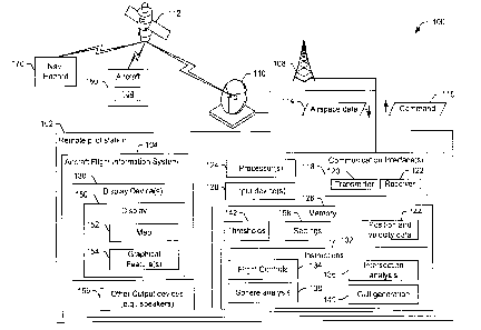
FIG. 1 is a block diagram that illustrates an example of a system 100
that includes an aircraft flight information system 104. The aircraft flight
information
system 104 is configured to facilitate operation of an aircraft 160 that is
controlled via
the aircraft flight information system 104. The aircraft flight information
system 104
is configured to provide a display 150 that includes information descriptive
of an
airspace near the aircraft 160. For example, the airspace can include a
navigation
hazard 170, which may be another aircraft, terrain, a structure, etc. The
aircraft flight
information system 104 is also configured to send commands 116 to the aircraft
160
based on pilot and/or autopilot flight control inputs. In FIG. 1, the aircraft
flight
information system 104 is a component of or integrated within a remote pilot
station
102 to enable remote piloting of the aircraft 160, or is a component of or
integrated
within the aircraft 160 or within another aircraft.
The aircraft flight information system 104 includes at least one
processor 124, a memory 126, one or more input devices 128, one or more
communication interfaces 118, a display device 130, and other output devices
156
(e.g., speakers, buzzers, lights, etc.). The memory 126, the input device(s)
128, the
communication interface 118, the display device 130, and other output devices
156
are directly or indirectly coupled to the processor(s) 124. The memory 126
stores
instructions 132 that are executable by the processor(s) 124 to perform
various
operations associated with receiving and presenting information descriptive of
an
airspace around the aircraft 160, presenting flight advice to a pilot,
receiving and
processing flight control input from the pilot, and communicating commands to
the
aircraft 160.
- 11 -
CA 3057695 2019-10-04
The communication interface 118 includes or is coupled to a
transmitter 120, a receiver 122, or a combination thereof (e.g., a
transceiver). The
communication interface 118 is configured to enable communication with the
aircraft
160, another aircraft, systems that gather or generate airspace data 114
descriptive
of the airspace around the aircraft 160, or a combination thereof. The
communication can include sending and/or receiving information generated at
the
aircraft 160 (e.g., audio, video, or sensor data), information generated at
other
aircraft (e.g., voice or transponder information), information generated at or
collected
by the aircraft flight information system 104 (e.g., commands), or a
combination
thereof. For example, the communication interface 118 is configured to receive
commands from the processor(s) 124 and to cause the transmitter 120 to send
the
commands, such as a command 116, to the aircraft 160. In FIG. 1, the command
116 is sent via a wireless transmission, such as via a terrestrial
radiofrequency
antenna 108 or via a satellite uplink between a satellite ground station
antenna 110
and one or more satellites 112. In implementations in which the aircraft
flight
information system 104 is integrated within the aircraft 160, the command 116
can
be transmitted via a bus or on-board data communication architecture of the
aircraft
160.
The receiver 122 is configured to receive the airspace data 114 and/or
other information via the terrestrial radiofrequency antenna 108, via the
satellite
uplink, via another source (such as a radar system or an air traffic control
system), or
a combination thereof. The airspace data 114 includes information such as the
position, velocity, altitude, and type of the aircraft 160 and of the
navigation hazard
170. The airspace data 114 can also include other information, such as notices
to
airmen, terrain and weather information. The airspace data 114 is provided to
the
processor(s) 124, stored in the memory 126, or both. For example, at least a
portion
of the airspace data 114 can be stored as position and velocity data 144.
The position and velocity data 144 is generated based on
measurements from sensors on-board the aircraft 160, sensors on-board the
navigation hazard 170, sensors on-board other aircraft or space-craft, ground-
based
- 12 -
CA 3057695 2019-10-04
sensors, or a combination thereof. The position and velocity data 144 can also
include uncertainty data indicating an estimate of error associated with each
sensor
or sensor reading. The uncertainty data can be included in the airspace data
114 or
can determined by the processor(s) 124 based on the type of sensor that
generated
the measurement, historical data, etc. The uncertainty data can include
position
uncertainty associated with a position of the aircraft 160, position
uncertainty
associated with a position of the navigation hazard 170, relative position
uncertainty
associated with a distance and direction between the aircraft 160 and the
navigation
hazard 170, velocity uncertainty associated with a velocity of the aircraft
160, velocity
uncertainty associated with a velocity of the navigation hazard 170, or a
combination
thereof. Uncertainty data can be provided, received, or retrieved from
multiple
different sources. For example, the uncertainty data can come from sensor
parameters, regulatory standards, navigation performance standards, or a
combination thereof. The uncertainty data can be adjusted (e.g., dynamically)
based
on flight conditions to determine position uncertainty, velocity uncertainty,
or both,
e.g., the uncertainty data can be a configurable variable. As an illustrative,
non-
limiting example, uncertainty data could be included in a data table and
includes
particular uncertainty data that indicates for a particular speed sensor
(e.g., a pitot
static tube) that a magnitude of velocity uncertainty is within "A" percent
when at "X"
altitude and is within "B" percent when at "Y" altitude. Additionally, a
resolution of
data inputs (indicating position, heading, speed, etc.) would influence the
uncertainty
in position data, velocity data, or both. For example, uncertainty in data
would
increase when a particular sensor has less resolution, e.g., when the
particular
sensor produces sensor data that has less significant digits as compared to
other
sensors.
In FIG. 1, the instructions 132 include flight control instructions 134,
sphere analysis instructions 138, intersection analysis instructions 136, and
graphical user interface (GUI) generation instructions 140. The flight control
instructions 134, the sphere analysis instructions 138, the intersection
analysis
instructions 136, and the GUI generation instructions 140 are illustrated as
separate
- 13 -
CA 3057695 2019-10-04
modules within the instructions 132 in FIG. 1 merely as a convenience. In some
implementations, two or more modules corresponding to the flight control
instructions
134, the sphere analysis instructions 138, the intersection analysis
instructions 136,
and the GUI generation instructions 140 are combined. To illustrate, the
sphere
analysis instructions 138 and the intersection analysis instructions 136 can
be
combined into a single application. In other implementations, the instructions
132
include different modules or more modules than are illustrated in FIG. 1. To
illustrate, the sphere analysis instructions 138 can be separated into several
modules, such as a module to identify bounding vectors based on the position
and
velocity data 144, a module to select a set of the bounding vectors for
analysis, and
a module to determine a set of Apollonius circles or Apollonius spheres based
on the
selected set of bounding vectors.
The flight control instructions 134 are executable by the processor(s)
124 to cause or enable the processor(s) 124 to receive input from a pilot via
the input
device(s) 128 and to generate commands (such as the command 116) for the
aircraft
160 based on the input. In some implementations, the flight control
instructions 134
can also, or in the alternative, include an autopilot system that controls the
aircraft
160 autonomously or semi-autonomously (e.g., autonomously within pilot
specified
parameters). In some implementations, the input device(s) 128 include
traditional
aircraft flight input devices, such as a stick, a throttle handle, a yoke,
pedals, or other
aircraft inceptors. In other implementations, the input device(s) 128
include
computer/gaming type input devices, such as a mouse, a keyboard, a joystick,
or a
game system controller. In yet other implementations, the input device(s) 128
include a combination of traditional aircraft flight input device,
computer/gaming-type
input device, other devices (e.g., gesture-, speech-, or motion-based
controllers).
The pilot can use the input device(s) 128 to directly command flight control
effectors
of the aircraft 160, such as by moving an input device in a manner that
indicates a
specific aileron position or a specific roll angle. Alternatively, or in
addition, the pilot
can use the input device(s) 128 to designate waypoints and/or operating
parameters,
and the flight control instructions 134 can command flight control effectors
of the
- 14 -
CA 3057695 2019-10-04
aircraft 160 based on the waypoint and/or operation parameters.
The GUI generation instructions 140 are executable by the
processor(s) 124 to cause or enable the processor(s) 124 to generate the
display
150 and to provide the display 150 to the display device(s) 130. In a
particular
implementation, the display 150 includes a map 152 representing a geographic
area
near the aircraft 160 and graphical features 154 that represent the aircraft
160, the
navigation hazard 170, flight status information, flight advice, and other
information.
The content and arrangement of the graphical features 154 can be determined
based on settings 158 in the memory 126. The settings 158 indicate pilot
display
preferences and other user selectable preferences regarding presentation of
information by the aircraft flight information system 104.
The sphere analysis instructions 138 are executable by the
processor(s) 124 to determine a plurality of bounding vectors based on the
position
and velocity data 144, as described further below. The sphere analysis
instructions
138 are also executable to select a set of the bounding vectors for analysis.
The
bounding vectors selected for further analysis are used to determine circular
or
spherical regions that bound candidate intersection points. For example, the
selected bounding vectors are used to generate data representing a plurality
of
Apollonius circles or Apollonius spheres. In a particular implementation, all
of the
bounding vectors identified by the sphere analysis instructions 138 are
selected and
used to generate Apollonius circles or Apollonius spheres. In other
implementations,
a subset of the bounding vectors identified by the sphere analysis
instructions 138
are selected and used to generate Apollonius circles or Apollonius spheres. In
yet
other implementations, a subset of the bounding vectors identified by the
sphere
analysis instructions 138 are selected and used to generate a first set of
Apollonius
circles or Apollonius spheres for a coarse estimate (e.g., to determine
whether a
potential loss of separation is indicated) and a larger subset, a different
subset, or all
of the bounding vectors identified by the sphere analysis instructions 138 are
selected and used to generate a second set of Apollonius circles or Apollonius
spheres for a fine estimate if a potential loss of separation is indicated by
the coarse
- 15 -
CA 3057695 2019-10-04
estimate. In such implementations, the aircraft flight information system 104
more
quickly updates the display device(s) 130 responsive to changes in position,
velocity,
position uncertainty, and velocity uncertainty at partial fidelity or
precision, and then
over time (e.g., subsequent processing cycles) updates or refines the coarse
estimate with one or more finer estimates to provide full fidelity or
precision.
The selected bounding vectors include one or more relative position
vectors, one or more velocity vectors for the aircraft 160, and one or more
velocity
vectors for the navigation hazard 170. Each relative position vector of the
one or
more relative position vectors indicates a direction and distance between the
aircraft
160 and the navigation hazard 170. If the position and velocity data 144
includes
position uncertainty data related to the position of the aircraft 160 or the
position of
the navigation hazard 170, the selected bounding vectors can include more than
one
relative position vector. In this situation, each relative position vector is
referred to
herein as a bounding relative position vector, i.e., a bounding vector that is
a relative
position vector. Position uncertainty can include vertical position
uncertainty (i.e.,
altitude uncertainty), horizontal position uncertainty, or both.
Each velocity vector indicates a speed and a direction. If the position
and velocity data 144 includes velocity uncertainty data related to the
velocity of the
aircraft 160, the selected bounding vectors can include more than one velocity
vector
for the aircraft 160. Likewise, if the position and velocity data 144 includes
velocity
uncertainty data related to the velocity of the navigation hazard 170, the
selected
bounding vectors can include more than one velocity vector for the navigation
hazard
170. As used herein a bounding vector that is a velocity vector is referred to
as a
bounding velocity vector. Velocity uncertainty can include uncertainty as to
speed
(e.g., the magnitude of the velocity vector) uncertainty as to direction of
the velocity
vector, or both.
The sphere analysis instructions 138 are executable by the at least one
processor 124 to generate data descriptive of each Apollonius circle or
Apollonius
sphere based on a speed ratio (e.g., a ratio of the magnitudes of bounding
velocity
- 16 -
CA 3057695 2019-10-04
vectors) of the aircraft 160 and the navigation hazard 170 and relative
positions (e.g,
a bounding relative position vector) of the aircraft 160 and the navigation
hazard 170.
In the example illustrated in FIG. 1, the data descriptive of each Apollonius
circle or
Apollonius sphere is provided to the intersection analysis instructions 136,
which
identify one or more points of intersection of a line projected along a
direction of one
of the velocity vectors and an Apollonius circle or Apollonius sphere.
Alternatively, or
in addition, the intersection analysis instructions 136 can determine a point
of closest
approach of the line projected along a direction of one of the velocity
vectors and an
Apollonius circle or Apollonius sphere. The point(s) of intersection or point
of closest
approach (along with points of intersection or point of closest approach from
analyses based on other bounding vectors) define a region of interest. Data
describing the region of interest is provided to the GUI generation
instructions 140 to
generate a situational awareness display (e.g., the display 150) for the
pilot.
Alternatively, or in addition, the data describing the region of interest can
be utilized
by the flight control instructions 134 to automatically or semi-automatically
generate
the commands 116 to cause the aircraft 160 to maneuver to avoid the region of
interest.
In a particular implementation, a region of interest is an area in which a
separation violation condition may occur. A separation violation condition
occurs
when the aircraft 160 is less than a separation threshold (e.g., a threshold
distance
or a threshold time) from the navigation hazard 170. The separation threshold
can
be specified by the pilot (e.g., as part of the settings 158), can be
specified by an
organization (e.g., a military, government, or commercial organization)
associated
with the aircraft 160 or the navigation hazard 170, can be specified by a
regulatory
agency, or can be specified by a standards organization. In some
implementations,
the thresholds 142 can include multiple different separation thresholds, and
the
specific separation threshold used to determine whether a separation violation
condition is expected to occur is determined based on conditions or parameter
values at the time when the airspace data 114 is received. For example, the
specific
separation threshold used can depend on weather conditions, an aircraft type
of the
- 17 -
CA 3057695 2019-10-04
aircraft 160, the class of airspace, the nature or identity of the navigation
hazard 170,
mission parameters, and so forth. To illustrate, a smaller separation
threshold can
be used when the aircraft 160 is unmanned and the navigation hazard 170 is
another
unmanned aircraft than may be used if either of the aircraft 160 or the
navigation
hazard 170 is a manned aircraft.
In some implementations, the GUI generation instructions 140 are
executable by the at least one processor 124 to generate a graphical feature
154 to
overlay the map 152 in an area corresponding to the region of interest.
Alternatively,
or in addition, the GUI generation instructions 140 generate an advice band or
other
graphical feature to indicate to the pilot that the pilot should not direct
the aircraft 160
in a direction corresponding to the region of interest.
In a particular implementation, the flight control instructions 134 can
limit operations that the pilot can perform based on the region of interest.
For
example, the flight control instructions 134 can prevent the pilot from
designating a
waypoint for the aircraft 160 that is within the region of interest. For
example, if the
pilot provides input that designates a waypoint, the command 116 can be
generated
and sent to the aircraft 160 based on a determination that the waypoint is not
located
in the region of interest. Alternatively, the flight control instructions 134
can allow the
pilot to designate the waypoint within the region of interest, but may require
the pilot
to perform one or more additional steps, such as a confirming that the pilot
understands that the waypoint is within the region of interest. For example,
based
on determining that the waypoint is within the region of interest, the
aircraft flight
information system 104 can generate output advising the pilot that the
waypoint is
within the region of interest, and await confirmation from the pilot before
setting the
waypoint.
FIG. 2A is a diagram that illustrates an example of an airspace 200 in
which multiple aircraft are present. The multiple aircraft include the
aircraft 160 and
another aircraft, which corresponds to the navigation hazard 170. FIG. 2A also
illustrates a heading of each aircraft in the airspace 200. For example, the
aircraft
- 18 -
CA 3057695 2019-10-04
160 has a heading 202, and the navigation hazard 170 has a heading 206. In the
example illustrated in FIG. 2A, the heading 202 of the aircraft 160 is toward
a
waypoint 204.
FIG. 2B is a diagram that illustrates an example of the display 150 for
the airspace 200 represented in FIG. 2A. The display 150 includes the map 152
and
graphical features 154 representing the aircraft 160 and the navigation hazard
170.
For example, the graphical representation 260 represents the aircraft 160 and
a
graphical representation 270 represents the navigation hazard 170. In FIG. 2B,
the
graphical features 154 also include a graphical representation 268 of the
waypoint
204 and a graphical representation 280 of a region of interest. The region of
interest
is based on a projected intersection of the aircraft 160, the navigation
hazard 170, or
both, with a candidate intersection point of a plurality of candidate
intersection points
determined based on bounding vectors associated with the aircraft 160 and the
navigation hazard 170, as explained further below.
The graphical features 154 also include a ring 264 around the graphical
representation 260 of the aircraft 160 and an advice band 266. The ring 264
helps
the pilot to quickly distinguish the graphical representation 260 of the
aircraft 160
(e.g., the aircraft being piloted) from other graphical features, which can
include
graphical representations of other aircraft, such as the navigation hazard
170. The
ring 264 can also include or be associated with other situational awareness
data,
such as data indicating an altitude of the aircraft 160, an identifier or type
of the
aircraft 160, etc. In some implementations, as size of the ring 264 is related
to a
speed of the aircraft 160. For example, the ring 264 can be sized such that
the
radius of the ring 264 corresponds to a distance the aircraft 160 will travel
during a
particular period (e.g., 3 minutes) based on its current speed.
In such
implementations, the size of the ring 264 together with a graphical indication
262 of
the heading 202 (along with information about the relationship between the
heading
202 and the course of the aircraft 160) gives the pilot an indication of the
velocity
vector of the aircraft 160.
- 19 -
CA 3057695 2019-10-04
The advice band 266 is an indication to the pilot of "do not steer"
direction. That is, the advice band 266 identifies a steering direction that
should be
avoided due to the presence of the region of interest.
While FIGS. 1 and 2, and the examples described below, refer to only
one aircraft 160 and one navigation hazard 170, the airspace 200 can include
more
than one aircraft 160, more than one navigation hazard 170, or both. For
example,
in a "crowded" airspace, many aircraft 160 can be present. In this situation,
each
aircraft 160 can fill both the role of the aircraft 160 (e.g., when
determining where
hazards to its own navigation are located) as well as the role of navigation
hazard
170 for other aircraft. Stated another way, every aircraft 160 can be
considered a
navigation hazard 170 for every other aircraft 160. In such situations, the
methods
described herein can be performed in a pairwise manner, where each pair
includes
one aircraft 160 and one navigation hazard 170, to detect regions of interest
for each
pair.
FIGS. 3A-13B illustrate various aspects of determining the region of
interest based on bounding vectors. In particular, FIGS. 3A, 3B, and 3C
illustrate
various aspects of position and velocity uncertainty, FIGS. 4A, 4B and 4C
illustrate
aspects of position uncertainty in more details, and FIGS. 5A and 5B
illustrate
aspects of velocity uncertainty in more details. FIGS. 6A-7C illustrate
aspects of a
method of generating data describing an Apollonius circle or a portion of an
Apollonius sphere (depicted in two-dimensions) based on velocity vectors, a
relative
position vector, and position uncertainty for either the aircraft 160 or the
navigation
hazard 170 (e.g., one-sided uncertainty). FIGS. 8A-8C illustrate aspects of a
method
of generating data describing an Apollonius circle or a portion of an
Apollonius
sphere (depicted in two-dimensions) based on velocity vectors, a relative
position
vector, and velocity uncertainty for either the aircraft 160 or the navigation
hazard
170 (e.g., one-sided uncertainty). FIGS. 9A-9C illustrate aspects of a method
of
generating data describing an Apollonius circle or a portion of an Apollonius
sphere
(depicted in two-dimensions) based on velocity vectors, a relative position
vector,
and position uncertainty for both the aircraft 160 and the navigation hazard
170 (e.g.,
- 20 -
CA 3057695 2019-10-04
two-sided uncertainty). FIGS. 10A-10B illustrate aspects of a method of
generating
bounding vectors (in two-dimensions) based on velocity vectors, a relative
position
vector, position uncertainty for both the aircraft 160 and the navigation
hazard 170
(e.g., two-sided uncertainty), and velocity uncertainty for both the aircraft
160 and the
navigation hazard 170 (e.g., two-sided uncertainty). FIGS. 11A-11B illustrate
aspects of a method of generating a reduced or simplified set of bounding
vectors (in
two-dimensions) based on the bounding vectors of FIGS. 10A-10B. FIG. 11C
illustrates one or more aspects of a method of generating data describing an
Apollonius circle or a portion of an Apollonius sphere (depicted in two-
dimensions)
based on the set of bounding vectors of FIGS. 11A-11B. FIGS. 12A-12B
illustrate
aspects of a method of generating bounding vectors (in three-dimensions) based
on
velocity vectors, a relative position vector, position uncertainty for both
the aircraft
160 and the navigation hazard 170 (e.g., two-sided uncertainty), and velocity
uncertainty for both the aircraft 160 and the navigation hazard 170 (e.g., two-
sided
uncertainty). FIGS. 13A-13B illustrate aspects of a method of generating a
reduced
or simplified set of bounding vectors (in three-dimensions) based on the
bounding
vectors of FIGS. 12A-12B.
FIG. 3A is a diagram illustrating position and velocity uncertainty in
two-dimensions (e.g., along an X axis and a Y axis). For purposes of the
description
herein, the diagram in FIG. 3A is considered to be a horizontal plane, and
thus, the
position uncertainty is referred to herein as horizontal position uncertainty
and the
velocity uncertainty is referred to herein as horizontal velocity uncertainty.
FIG. 3A
also includes a vector key illustrating how velocity vectors and relative
position
vectors are illustrated to facilitate distinguishing the two types of vectors
in FIGS. 3A-
13B.
FIG. 3A illustrates two reported positions including a first position 302
and a second position 304. One of the positions 302, 304 corresponds to the
position of the aircraft 160 of FIG. 1, and the other of the positions 302,
304
corresponds to the position of the navigation hazard 170 of FIG. I. For
convenience
of description, the position 302 is described as corresponding to the position
of the
- 21 -
CA 3057695 2019-10-04
aircraft 160, and the position 304 is described as corresponding to the
position of the
navigation hazard 170; however, this description is merely for convenience and
is
not a limitation.
For purposes of detecting regions of interest (e.g, points of closest
approach, loss of separation, or points of possible intersection), absolute
position of
the aircraft 160 and the navigation hazard 170 is not needed; relative
position is
sufficient. FIG. 3A illustrates a relative position vector 306 which indicates
a
direction and distance between the positions 302, 304. Since relative position
can
be used, the directions of the X and Y axes of the coordinate system are
arbitrary.
For purpose of illustration, and to simplify the geometric calculations, the
positions
302 and 304 can be assumed to be on the X axis with the position 302 at an
origin of
the coordinate system.
As indicated above, the positions 302, 304 are reported positions (e.g.,
positions determined based on measurements) and as such may be subject to
measurement error. As a result of the measurement error, the actual position
of the
aircraft 160 could be displaced from the reported position 302 in either
direction
along the Y axis, in either direction along the X axis, or both. Likewise, the
actual
position of the navigation hazard 170 could be displaced from the report
position 304
in either direction along the Y axis, in either direction along the X axis, or
both.
Accordingly, uncertainty associated with the positions 302 and 304 is
illustrated in
FIG. 3A using dashed-line circles and is referred to herein as horizontal
position
uncertainty 308 associated with the position 302 and horizontal position
uncertainty
310 associated with the position 304.
FIG. 3A also illustrates a velocity vector 312 of the aircraft 160 and a
velocity vector 314 of the navigation hazard 170. Each velocity vector 312,
314 has
a direction (e.g., indicating the course of the aircraft 160 or the navigation
hazard
170) and a magnitude (corresponding to the speed of the aircraft 160 or the
navigation hazard 170). The velocity of the aircraft 160, the velocity of the
navigation
hazard 170, or both, may be subject to measurement error. Velocity measurement
is
- 22 -
CA 3057695 2019-10-04
subject to at least two kinds or measurement error including magnitude error
(e.g.,
error as to speed) and direction error. As a result of the direction error,
the actual
velocity of the aircraft 160 could be angularly offset from the velocity
vector 312 in
either direction with respect to the X axis. That is, the angle between the X
axis and
the velocity vector 312 could be greater than reported or less than reported.
As a
result of the magnitude (or speed) error, the actual velocity of the aircraft
160 could
be greater than reported or less than reported. Accordingly, velocity
uncertainty 316
associated with the velocity vector 312 is illustrated in FIG. 3A using a
dotted-line
circle. Each point on or within the dotted-line circle corresponds to a
possible end
point for the velocity vector 312. Likewise, velocity uncertainty 318
associated with
the velocity vector 314 is illustrated in FIG. 3A using a dotted-line circle
where each
point on or within the dotted-line circle corresponds to a possible end point
for the
velocity vector 314.
FIG. 3B illustrates the first position 302 and the second position 304 in
a plane along the X axis and a Z axis of the coordinate system. Thus, FIG. 3B
represents the relative positions and velocity vectors of the aircraft 160 and
the
navigation hazard 170 in a vertical plane.
As illustrated in FIG. 3B, the positions 302, 304 can also be subject to
vertical measurement error. As a result of the vertical measurement error, the
actual
position (e.g., altitude) of the aircraft 160 could be displaced from the
reported
position 302 in either direction along the Z axis. Likewise, the actual
position (e.g.,
altitude) of the navigation hazard 170 could be displaced from the report
position 304
in either direction along the Z axis. Accordingly, uncertainty associated with
the
positions 302 and 304 is illustrated in FIG. 3B using dashed-line boxes and is
referred to herein as vertical position uncertainty 308 associated with the
position
302 and vertical position uncertainty 310 associated with the position 304.
FIG. 3B also illustrates the velocity vector 312 of the aircraft 160, the
velocity vector 314 of the navigation hazard 170, and the relative position
vector 306.
As illustrated in FIG. 3B, the actual velocity of the aircraft 160 could be
angularly
- 23 -
CA 3057695 2019-10-04
offset from the velocity vector 312 in either direction with respect to the Z
axis. That
is, the angle between the Z axis and the velocity vector 312 could be greater
than
reported or less than reported. Accordingly, the velocity uncertainty 316
associated
with the velocity vector 312 is illustrated in FIG. 3B using a dotted-line
circle in the
X/Z plane where each point on or within the dotted-line circle corresponds to
a
possible end point for the velocity vector 312. Likewise, the velocity
uncertainty 318
associated with the velocity vector 314 is illustrated in FIG. 3B using a
dotted-line
circle where each point on or within the dotted-line circle corresponds to a
possible
end point for the velocity vector 314.
FIG. 3C illustrates the first position 302 and the second position 304 in
a three-dimensional (3D) coordinate system including the X, Y and Z axes. In
FIG.
3C, the position uncertainty 308 associated with the position 302 of the
aircraft 160 is
represented as a "hockey puck" shape (e.g. a cylinder). The cylinder
represents
horizontal position uncertainty (as in FIG. 3A) and vertical position
uncertainty (as in
FIG. 3B). Likewise, the position uncertainty 310 associated with the position
304 of
the navigation hazard 170 is represented as a cylinder corresponding to
vertical and
horizontal position uncertainty. In FIG. 3C, the velocity uncertainty 316
associated
with the velocity vector 312 is represented as a sphere to account for angular
error in
any direction as well as magnitude (or speed) error, and the velocity
uncertainty 318
associated with the velocity vector 314 is represented as a sphere to account
for
angular error in any direction as well as magnitude (or speed) error.
FIGS. 3A, 3B, and 3C illustrate the position uncertainty 308, 310 and
the velocity uncertainty 316, 318 as symmetric merely for convenience. For
example, in FIG. 3B, the position uncertainty 308 is represented in a manner
that
may imply that the altitude of the aircraft 160 may be a particular distance
above the
position 302 or an equal distance below the position 302. However, in some
implementations, the measurement error is not symmetric in this manner. For
example, an altitude measurement sensor may be configured to err on the side
of
indicating a lower altitude (to ensure adequate clearance from terrain), in
which case
the position uncertainty may be shifted relative out of symmetry. As another
- 24 -
CA 3057695 2019-10-04
example, different sensors can be used to measure vertical velocity than to
measure
lateral or horizontal velocity, and the different sensors can be subject to
different
levels of measurement error. As a result, the velocity uncertainty 316 may be
elongated or compressed along the Z axis relative to along the X and Y axis
leading
to a somewhat non-spherical velocity uncertainty.
FIGS. 4A-4C are diagrams illustrating bounding position vectors based
on the position uncertainties 308 and 310 illustrated in FIGS. 3A-3C,
respectively.
FIG. 4A illustrates a set of bounding vectors 300 based on horizontal position
uncertainty, FIG. 4B illustrates a set of bounding vectors 350 based on
vertical
position uncertainty, and FIG. 4C illustrates a set of bounding vectors 370
based on
horizontal and vertical position uncertainty. Each bounding vector of each of
the sets
of bounding vectors 300, 350, 370 extends between an offset position of the
aircraft
160 and an offset position of the navigation hazard 170.
In FIG. 4A, the offset positions of the navigation hazard 170 include an
offset position 408 corresponding to a horizontal offset from the position 304
in a
direction away from the position 302 by a maximum value of the horizontal
position
uncertainty 310. The offset positions of the navigation hazard 170 also
include an
offset position 412 corresponding to a horizontal offset from the position 304
in a
direction toward the position 302 by a maximum value of the horizontal
position
uncertainty 310. The offset positions of the navigation hazard 170 also
include an
offset position 414 and an offset position 410. The offset positions of the
aircraft 160
include an offset position 402, an offset position 404, and an offset position
406. The
offset position 402 of the aircraft 160 corresponds to a horizontal offset
from the
position 302 in a direction away from the position 304 by a maximum value of
the
horizontal position uncertainty 308. The offset position 414 of the navigation
hazard
170 and the offset position 406 of the aircraft 160 are positioned on a line
422 that is
tangent to the position uncertainty 308 (e.g., is tangent to a border of a
circular range
of possible positions of the aircraft 160) and is tangent to the position
uncertainty 310
(e.g., is tangent to a border of a circular range of possible positions of the
navigation
hazard 170). The offset position 410 of the navigation hazard 170 and the
offset
- 25 -
CA 3057695 2019-10-04
position 404 of the aircraft 160 are positioned on a line 426 that is tangent
to the
position uncertainty 308 (e.g., is tangent to a border of a circular range of
possible
positions of the aircraft 160) and is tangent to the position uncertainty 310
(e.g., is
tangent to a border of a circular range of possible positions of the
navigation hazard
170).
The set of bounding vectors 300 illustrated in FIG. 4A includes a
relative position vector 416 that extends between the offset position 402 and
the
offset position 412. Put another way, in the illustration in FIG. 4A, the
relative
position vector 416 extends between the left most points of the position
uncertainties
308, 310. In some implementations, the direction in which the offset positions
402
and 412 are shifted from the positions 302 and 304 is related to the speeds of
the
aircraft 160 and the navigation hazard 170. For example, in FIG. 4A, the speed
of
the aircraft 160 (corresponding to the magnitude of the velocity vector 312)
is greater
than the speed of the navigation hazard 170 (corresponding to the magnitude of
the
velocity vector 314). In this example, the relative position vector 416
extends
between a portion of the position uncertainty 310 of the navigation hazard 170
that is
closest to the aircraft 160 (i.e., the offset position 412) to a portion of
the position
uncertainty 308 of the aircraft 160 that is furthest from the navigation
hazard 170
(i.e., the offset position 402). However, if the speed of the aircraft 160 is
less than
the speed of the navigation hazard 170, the relative position vector 416
extends
between a portion of the position uncertainty 310 of the navigation hazard 170
that is
furthest from the aircraft 160 (i.e., the offset position 408) to a portion of
the position
uncertainty 308 of the aircraft 160 that is closest to the navigation hazard
170. If the
velocity vectors 312 and 314 are of similar magnitude and/or if the velocity
uncertainty is large for one or both of the aircraft 160 and the navigation
hazard 170,
it may be uncertain whether the aircraft 160 and the navigation hazard 170 is
moving
faster. In this situation, two versions of the relative position vector 416
can be used,
where the two versions correspond to the two examples described above.
- 26 -
CA 3057695 2019-10-04
The set of bounding vectors 300 illustrated in FIG. 4A includes a
relative position vector 418 that extends between the offset position 402 and
the
offset position 408. The relative position vector 418 extends between
maximally
horizontally distance points of the position uncertainties 308, 310.
The set of bounding vectors 300 illustrated in FIG. 4A also includes a
relative position vector 424 that extends between the offset position 404 and
the
offset position 410, and includes a relative position vector 420 that extends
between
the offset position 406 and the offset position 414. The relative position
vectors 420
and 424 correspond to maximally angularly offset portions of the position
uncertainties 308, 310.
In FIG. 4B, the offset positions of the navigation hazard 170 include an
offset position 432 corresponding to a vertical offset from the position 304
in a first
direction along the Z axis by a maximum value of the vertical position
uncertainty
310. The offset positions of the navigation hazard 170 also include an offset
position
434 corresponding to a vertical offset from the position 304 in a second
direction
(opposite the first direction) along the Z axis by the maximum value of the
vertical
position uncertainty 310. Likewise, the offset positions of the aircraft
include an
offset position 428 corresponding to a vertical offset from the position 302
in the first
direction along the Z axis by a maximum value of the vertical position
uncertainty
308 and an offset position 430 corresponding to a vertical offset from the
position
302 in the second direction along the Z axis by the maximum value of the
vertical
position uncertainty 308. The set of bounding vectors 350 illustrated in FIG.
4B
includes a relative position vector 436 that extends between the offset
position 428
and the offset position 434, and includes a relative position vector 438 that
extends
between the offset position 430 and the offset position 432.
In FIG. 40, the offset positions of the aircraft 160 and the navigation
hazard 170 are the same as the offset positions 402-414 of FIG. 4A but offset
vertically as in the manner illustrated in FIG. 4B. For example, the offset
positions of
the aircraft 160 in FIG. 4C include an offset position 440, which corresponds
to the
- 27 -
CA 3057695 2019-10-04
offset position 402 vertically offset in the same manner as the offset
position 428.
The offset positions of the aircraft 160 in FIG. 4C also include an offset
position 442
corresponding to the offset position 404 vertically offset in the same manner
as the
offset position 428 and an offset position 446 corresponding to the offset
position
406 vertically offset in the same manner as the offset position 428. The
offset
positions of the aircraft 160 in FIG. 4C also include an offset position 448
corresponding to the offset position 402 vertically offset in the same manner
as the
offset position 430, an offset position 450 corresponding to the offset
position 404
vertically offset in the same manner as the offset position 430, and an offset
position
452 corresponding to the offset position 406 vertically offset in the same
manner as
the offset position 430.
Additionally, the offset positions of the navigation hazard 170 in FIG.
4C include an offset position 454, which corresponds to the offset position
408
vertically offset in the same manner as the offset position 432. The offset
positions
of the navigation hazard 170 in FIG. 4C also include an offset position 456
corresponding to the offset position 410 vertically offset in the same manner
as the
offset position 432, an offset position 458 corresponding to the offset
position 412
vertically offset in the same manner as the offset position 432, and an offset
position
460 corresponding to the offset position 414 vertically offset in the same
manner as
the offset position 432. The offset positions of the navigation hazard 170 in
FIG. 4C
also include an offset position 462 corresponding to the offset position 408
vertically
offset in the same manner as the offset position 434, an offset position 464
corresponding to the offset position 410 vertically offset in the same manner
as the
offset position 434, an offset position 466 corresponding to the offset
position 412
vertically offset in the same manner as the offset position 434, and an offset
position
468 corresponding to the offset position 414 vertically offset in the same
manner as
the offset position 434.
The set of bounding vectors 370 illustrated in FIG. 4C includes a
relative position vector 472 that extends between the offset position 448 and
the
offset position 458 and a relative position vector 484 that extends between
the offset
-28 -
CA 3057695 2019-10-04
position 440 and the offset position 466. The set of bounding vectors 370 also
includes a relative position vector 476 that extends between the offset
position 448
and the offset position 454 and a relative position vector 480 that extends
between
the offset position 440 and the offset position 462. The set of bounding
vectors 370
also includes a relative position vector 482 that extends between the offset
position
442 and the offset position 464 and a relative position vector 474 that
extends
between the offset position 450 and the offset position 456. The set of
bounding
vectors 370 also includes a relative position vector 478 that extends between
the
offset position 446 and the offset position 468 and a relative position vector
470 that
extends between the offset position 452 and the offset position 460.
FIGS. 5A and 5B are diagrams illustrating bounding velocity vectors
based on the velocity uncertainties 316, 318 illustrated in FIGS. 3A and 3B,
respectively. FIG. 5A illustrates vectors of a set of bounding vectors 500
based on
the velocity uncertainty 316 in the horizontal plane and vectors of a set of
bounding
vectors 550 based on the velocity uncertainty 318 in the horizontal plane.
FIG. 5B
illustrates vectors of the set of bounding vectors 500 based on the velocity
uncertainty 316 in the vertical plane and vectors of the set of bounding
vectors 550
based on the velocity uncertainty 318 in the vertical plane.
The set of bounding vectors 500 includes a velocity vector 502
representing a maximum speed of the aircraft 160 in view of the velocity
uncertainty
316 and includes a velocity vector 504 representing a minimum speed of the
aircraft
160 in view of the velocity uncertainty 316. The set of bounding vectors 500
includes
a velocity vector 506 (as shown in FIG. 5A), a velocity vector 510 (as shown
in FIG.
5A), a velocity vector 526 (as shown in FIG. 5B), and a velocity vector 530
(as
shown in FIG. 5B). Each of the velocity vectors 506, 510, 526, and 530
represent a
maximum angular offset of the aircraft's velocity from the reported velocity
in view of
the velocity uncertainty 316. For example, the velocity vector 506 is on a
line 508
that is tangent to the velocity uncertainty 316 (e.g., is tangent to a border
of a circular
range of possible angular directions of the velocity of the aircraft 160)
resulting in a
maximum angular offset (in a first direction) from the reported velocity of
the aircraft
- 29 -
CA 3057695 2019-10-04
160 based on the velocity uncertainty 316. The velocity vector 510 is on a
line 512
that is tangent to the velocity uncertainty 316 resulting in a maximum angular
offset
(in a second direction opposite the first direction) from the reported
velocity of the
aircraft 160 based on the velocity uncertainty 316. Likewise, in the vertical
plane, the
velocity vector 526 is on a line 528 that is tangent to the velocity
uncertainty 316
resulting in a maximum angular offset (in a third direction) from the reported
velocity
of the aircraft 160 based on the velocity uncertainty 316, and the velocity
vector 530
is on a line 532 that is tangent to the velocity uncertainty 316, resulting in
a
maximum angular offset (in a fourth direction opposite the third direction)
from the
reported velocity of the aircraft 160 based on the velocity uncertainty 316.
The set of bounding vectors 550 includes a velocity vector 514
representing a maximum speed of the navigation hazard 170 in view of the
velocity
uncertainty 318 and includes a velocity vector 516 representing a minimum
speed of
the navigation hazard 170 in view of the velocity uncertainty 318. The set of
bounding vectors 550 includes a velocity vector 518 (as shown in FIG. 5A), a
velocity
vector 522 (as shown in FIG. 5A), a velocity vector 534 (as shown in FIG. 5B),
and a
velocity vector 538 (as shown in FIG. 5B). Each of the velocity vectors 518,
522,
534, and 538 represent a maximum angular offset of the navigation hazard's
velocity
from the reported velocity in view of the velocity uncertainty 318. For
example, the
velocity vector 518 is on a line 520 that is tangent to the velocity
uncertainty 318
resulting in a maximum angular offset (in a first direction) from the reported
velocity
of the navigation hazard 170 based on the velocity uncertainty 318, and the
velocity
vector 522 is on a line 524 that is tangent to the velocity uncertainty 318
resulting in
a maximum angular offset (in a second direction opposite the first direction)
from the
reported velocity of the navigation hazard 170 based on the velocity
uncertainty 318.
Likewise, in the vertical plane, the velocity vector 534 is on a line 536 that
is tangent
to the velocity uncertainty 318 resulting in a maximum angular offset (in a
third
direction) from the reported velocity of the navigation hazard 170 based on
the
velocity uncertainty 318, and the velocity vector 538 is on a line 540 that is
tangent to
the velocity uncertainty 318 resulting in a maximum angular offset (in a
fourth
- 30 -
CA 3057695 2019-10-04
direction opposite the third direction) from the reported velocity of the
navigation
hazard 170 based on the velocity uncertainty 318.
FIGS. 6A-6C illustrate an example of using the bounding vectors
described with reference to FIG. 4A to identify a region of interest 620. The
example
illustrated in FIGS. 6A-6C represents a simplified circumstance in which the
only
uncertainty accounted for is with respect to the position 302. That is, only
the
horizontal position of the aircraft 160 or the horizontal position of the
navigation
hazard 170 is uncertain. FIGS. 6A-6C thus represent a one-sided position
uncertainty situation in two dimensions with no velocity uncertainty.
The example illustrated in FIGS. 6A-6C may apply, for example, to a
situation in which a velocity sensor that reported the velocity vector 312, a
velocity
sensor that reported the velocity vector 314, an altitude sensor that reported
a
vertical component of the position 302, an altitude sensor that reported a
vertical
component of the position 304, and a position sensor that reported horizontal
components of the position 304 are much more reliable than the position sensor
that
reported horizontal components of the position 302. To illustrate, the
position 302
can be based on dead reckoning or visual estimation from a pilot while the
other
values are reported from accurate sensors systems, such as global position
systems, radar, lidar, etc. As another example, the relative positions of the
aircraft
160 and the navigation hazard 170 can be determined using a return signal of a
ranging and direction system (e.g., radar or lidar) of the aircraft 160. In
this situation,
the absolute position of the aircraft 160 may not be known (or may not be
used).
Rather, the aircraft 160 is treated as an origin point of a coordinate system
and the
position uncertainty 308 is related to the relative position of the navigation
hazard
170 with respect to the aircraft 160 and is thus one-sided. As yet another
example,
the process described with reference to FIGS. 6A-6C can be performed twice to
approximate two-sided position uncertainty. To illustrate, the process can be
performed once to account for the position uncertainty 308 associated with the
position 302 and another time to account for the position uncertainty 310
associated
with the position 304. Applying the single position uncertainty process twice
does
- 31 -
CA 3057695 2019-10-04
not account for extremes in angle and/or distance that may occur when
considering
position uncertainty for both the aircraft 160 and the navigation hazard 170
together.
For example, the results from possible relative position vectors 424, 418 or
420, as
shown in FIG. 4A, may not be achieved.
Under the circumstances illustrated in FIG. 6A, the set of bounding
(position) vectors 300 includes the relative position vector 424 between the
offset
position 404 and the position 304, the relative position vector 416 between
the offset
position 402 and the position 304, and the relative position vector 420
between the
offset position 406 and the position 304. No velocity uncertainty is
considered, so
the velocity vectors 312, 314 are used rather than bounding velocity vectors.
A
comparison 608 of the magnitudes of the velocity vectors 312 and 314 indicates
that
the velocity vector 312 corresponds to a speed that is approximately three
times the
speed represented by the velocity vector 314. Stated another way, a speed
ratio of
the velocity vectors 312, 314 is approximately 3:1.
FIG. 6B illustrates cases 602, 604, 606 to be evaluated based on the
bounding vectors of FIG. 6A. A case 602 is based on the relative position
vector 416
and corresponds to the aircraft 160 being located at the offset position 402
and
having the velocity vector 312 and the navigation hazard 170 being located at
the
position 304 and having the velocity vector 314. A case 604 is based on the
relative
position vector 424 and corresponds to the aircraft 160 being located at the
offset
position 404 and having the velocity vector 312 and the navigation hazard 170
being
located at the position 304 and having the velocity vector 314. A case 606 is
based
on the relative position vector 420 and corresponds to the aircraft 160 being
located
at the offset position 406 and having the velocity vector 312 and the
navigation
hazard 170 being located at the position 304 and having the velocity vector
314.
Each of the cases 602, 604, 606 is used to generate an Apollonius
circle. FIG. 6C illustrates the resulting Apollonius circles 607, 610, 612. An
Apollonius circle 607 is determined based on the relative position vector 416
and a
speed ratio of the velocity vectors 312 and 314. An Apollonius circle 610 is
- 32 -
CA 3057695 2019-10-04
determined based on the relative position vector 424 and a speed ratio of the
velocity vectors 312 and 314. An Apollonius circle 612 is determined based on
the
relative position vector 420 and a speed ratio of the velocity vectors 312 and
314.
Each of the Apollonius circles 607, 610, 612 is formed (or bounded) by a
plurality of
candidate intersection points of the aircraft 160 and the navigation hazard
170 based
on the respective relative position vector and the velocity vectors. That is,
accounting for just current position and speed, the aircraft 160 and the
navigation
hazard 170 could intersect at any point on an Apollonius circles 607, 610,
612.
Since the Apollonius circles 607, 610, 612 are determined based on
the relative position vectors 416, 420, 424 and the speed ratio of the
velocity vectors
312, 314, the Apollonius circles 607, 610, 612 do not account for
directionality of the
velocity vectors 312, 314. In FIG. 6C, the velocity vector 312 is extended (as
indicated by lines 614, 616, and 618) to identify intersections with the
Apollonius
circles 607, 610, 612, points of closest approach to the Apollonius circles
607, 610,
612, or both. Each of the lines 614, 616, 618 can intersect an Apollonius
circle 607,
610, 612 twice (corresponding to entering and leaving the circle), once
(corresponding to being tangent to the circle), or not at all.
If a line 614, 616, 618 intersects an Apollonius circle 607, 610, 612 at
two points, the region of interest 620 corresponds to (or includes) a region
between
the line 614, 616, 618 and the boundary of the Apollonius circle 607, 610,
612. For
example, in FIG. 6C, the region of interest 620 corresponds to or includes the
shaded area between the line 618 and the boundary of the circle 610. In some
implementations, the region of interest 620 can also include the shaded area
between the line 618 and the boundary of the circle 607. In some
implementations,
the region of interest 620 can also include an area extending some threshold
distance (e.g., a separation distance) around the area between the line 618
and the
boundary of the circle 610 or 607.
=
- 33 -
CA 3057695 2019-10-04
If more than one line 614, 616, 618 intersects an Apollonius circle 607,
610, 612 at two points, the region of interest 620 corresponds to (or
includes) a
region between at least two of the lines 614, 616, 618 and the boundary of the
Apollonius circle 607, 610, 612. For example, when both of the lines 616 and
618
intersect the Apollonius circle 607 at two points, the region of interest 620
corresponds to or includes the region between the line 616 and the line 618
that is
enclosed within the Apollonius circle 607 (i.e., a region bounded by the lines
616,
618 and the Apollonius circle 607).
If a line 614, 616, 618 intersects an Apollonius circle 607, 610, 612 at
.. one point, the region of interest 620 corresponds to or includes the
intersection
point(s). In some implementations, the region of interest 620 corresponds to
or
includes a region extending a threshold distance (e.g., the separation
distance)
around the intersection point(s). In other implementations, the region of
interest 620
corresponds to or includes a region between the line 614, 616, 618 and the
boundary of the circle 607, 610, 612. If a line 614, 616, 618 does not
intersect an
Apollonius circle 607, 610, 612, the points of closest approach corresponding
to the
aircraft 160 and the navigation hazard 170 can be determined for each case
602,
604, and 606. If the distance between the aircraft 160 and the navigation
hazard 170
at the point of closest approach is greater than (or greater than or equal to)
a
threshold distance (e.g., the separation distance) no region of interest is
identified. If
the distance between the aircraft 160 and the navigation hazard 170 at the
point of
closest approach is less than (or less than or equal to) the threshold
distance (e.g.,
the separation distance) the region of interest is an area around and
including the
point of closest approach corresponding to the aircraft 160, the point of
closest
approach corresponding to the navigation hazard 170, or both.
FIGS. 7A-7C illustrate an example of using the bounding vectors
described with reference to FIG. 4B to identify a region of interest 620. The
example
illustrated in FIGS. 7A-7C represent a simplified circumstance in which only
the
vertical position of the aircraft 160 or the vertical position of the
navigation hazard
170 is 'uncertain. Thus, FIGS. 7A-7C represent a one-sided position
uncertainty
- 34 -
CA 3057695 2019-10-04
situation in two dimensions with no velocity uncertainty, and are conceptually
identical to the example described with reference to FIGS. 6A-6C except for
using
vertical position uncertainty rather than horizontal position uncertainty.
Under the circumstances illustrated in FIG. 7A, the set of bounding
vectors 350 includes the relative position vector 436 between the offset
position 428
and the position 304 and the relative position vector 438 between the offset
position
430 and the position 304. No velocity uncertainty is considered, so the
velocity
vectors 312, 314 are used rather than bounding velocity vectors. A comparison
608
of the magnitudes of the velocity vectors 312 and 314 indicates that the
velocity
vector 312 corresponds to a speed that is approximately three times the speed
represented by the velocity vector 314. Stated another way, a speed ratio of
the
velocity vectors 312, 314 is approximately 3:1.
FIG. 7B illustrates cases 702, 704 to be evaluated based on the
bounding vectors of FIG. 7A. A case 702 is based on the relative position
vector 436
and corresponds to the aircraft 160 being located at the offset position 428
and
having the velocity vector 312 and the navigation hazard 170 being located at
the
position 304 and having the velocity vector 314. A case 704 is based on the
relative
position vector 438 and corresponds to the aircraft 160 being located at the
offset
position 430 and having the velocity vector 312 and the navigation hazard 170
being
located at the position 304 and having the velocity vector 314.
Each of the cases 702, 704 is used to generate an Apollonius circle.
FIG. 7C illustrates the resulting Apollonius circles 706, 708. An Apollonius
circle 706
is determined based on the relative position vector 436 and a speed ratio of
the
velocity vectors 312 and 314, and an Apollonius circle 708 is determined based
on
the relative position vector 438 and a speed ratio of the velocity vectors 312
and 314.
In FIG. 7C, the velocity vector 312 is extended (as indicated by lines
710 and 712) to identify intersections with the Apollonius circles 706, 708,
points of
closest approach 622 to the Apollonius circles 706, 708, or both. The
intersections
- 35 -
CA 3057695 2019-10-04
of the lines 710, 712 with the Apollonius circles 706, 708 or the points of
closest
approach to the Apollonius circles 706, 708 are used to determine the region
of
interest 620 in an analogous manner as described with reference to FIG. 6C.
FIGS. 8A-8C illustrate an example of using the bounding vectors
described with reference to FIG. 5A to identify a region of interest 620. The
example
illustrated in FIGS. 8A-80 represents a simplified circumstance in which only
the
horizontal velocity of the aircraft 160 or the horizontal velocity of the
navigation
hazard 170 is uncertain. Thus, FIGS. 8A-8C represent a one-sided velocity
uncertainty situation in two dimensions with no position uncertainty.
Under the circumstances illustrated in FIG. 8A, the position vector 306
describes the distance and direction between the position 302 and the position
304.
The velocity of the navigation hazard 170 is indicated by the velocity vector
314, and
the velocity of the aircraft 160 is associated with velocity uncertainty
bounded by the
set of velocity vectors 500. The set of velocity vectors 500 includes the
velocity
vector 502, the velocity vector 504, the velocity vector 506, and the velocity
vector
510. The comparison 608 illustrates the magnitudes of the velocity vectors
314, 502,
504, 506, and 510. The velocity vectors 506 and 510 are symmetrically offset
from
the reported velocity resulting in the velocity vectors 506 and 510 having the
same
magnitude but different directions. As illustrated in the comparison 608, the
velocity
vector 502 corresponds to a speed that is approximately three times the speed
represented by the velocity vector 314 (e.g., a speed ratio of about 3:1), the
velocity
vectors 506 and 510 correspond to speeds that are approximately two times the
speed represented by the velocity vector 314 (e.g., a speed ratio of about
2:1), and
the velocity vector 504 corresponds to a speed that is approximately one and a
half
times the speed represented by the velocity vector 314 (e.g. a speed ratio of
about
1.5:1).
FIG. 8B illustrates cases 802, 804, 806, 808 to be evaluated based on
the bounding vectors of FIG. 8A. A case 802 is based on the relative position
vector
306, the velocity vector 502, and the velocity vector 314. A case 804 is based
on the
- 36 -
CA 3057695 2019-10-04
relative position vector 306, the velocity vector 504, and the velocity vector
314. A
case 806 is based on the relative position vector 306, the velocity vector
510, and
the velocity vector 314. A case 808 is based on the relative position vector
306, the
velocity vector 506, and the velocity vector 314.
Each of the cases 802, 804, 806, 808 is used to generate an
Apollonius circle. As described above, the Apollonius circles are based on the
positions of the aircraft 160 and the navigation hazard 170 and a speed ratio
of the
aircraft 160 and the navigation hazard 170, without regard for the direction
of the
velocity vectors 500. Since, the speed ratio based on the velocity vector 506
and the
velocity vector 314 is equal to the velocity vector 510 and the velocity
vector 314, the
Apollonius circle based on the velocity vector 506 and the velocity vector 314
and
the Apollonius circle based on the velocity vector 510 and the velocity vector
314 are
identical.
FIG. 8C illustrates the resulting Apollonius circles 810, 812, 814. An
Apollonius circle 810 is determined based on the case 802, an Apollonius
circle 812
is determined based on the cases 806 and/or 808, and an Apollonius circle 814
is
determined based on the case 804. In FIG. 8C, the velocity vectors 502, 504,
506,
510 are extended (as indicated by lines 816, 818, and 820) to identify
intersections
with the Apollonius circles 810, 812, 814, points of closest approach, or
both, to
determine the region of interest 620. Similarly, when only the vertical
velocity of the
aircraft 160 or the vertical velocity of the navigation hazard 170 is
uncertain, the
methods described in FIGS. 8A-8C can be used to identify a region of interest
620
based on the bounding vectors described with reference to FIG. 5A. For
example,
for aircraft at similar positions but different altitudes horizontal velocity
uncertainty
may be omitted.
FIGS. 9A-9C illustrate an example of using the bounding vectors
described with reference to FIG. 4A to identify a region of interest 620. The
example
illustrated in FIGS. 9A-9C represents a simplified circumstance which accounts
for
two-dimensional position uncertainty. That is, the horizontal position of the
aircraft
- 37 -
CA 3057695 2019-10-04
160 and the horizontal position of the navigation hazard 170 are uncertain.
Thus,
FIGS. 9A-9C represent a two-sided position uncertainty situation in two
dimensions
with no velocity uncertainty.
Under the circumstances illustrated in FIG. 9A, the set of bounding
(position) vectors 300 includes the relative position vector 424 between the
offset
position 404 and the offset position 410, the relative position vector 416
between the
offset position 402 and the offset position 412, the relative position vector
418
between the offset position 402 and the offset position 408, and the relative
position
vector 420 between the offset position 406 and the offset position 414. No
velocity
uncertainty is considered, so the velocity vectors 312, 314 are used rather
than
bounding velocity vectors. The comparison 608 of the magnitudes of the
velocity
vectors 312 and 314 indicates that the velocity vector 312 corresponds to a
speed
that is approximately three times the speed represented by the velocity vector
314.
Stated another way, a speed ratio of the velocity vectors 312, 314 is
approximately
3:1.
FIG. 9B illustrates cases 902, 904, 906, and 908 to be evaluated based
on the bounding vectors of FIG. 9A. The case 902 is based on the relative
position
vector 418 and corresponds to the aircraft 160 being located at the offset
position
402 and having the velocity vector 312 and the navigation hazard 170 being
located
at the position 408 and having the velocity vector 314. The case 904 is based
on the
relative position vector 416 and corresponds to the aircraft 160 being located
at the
offset position 402 and having the velocity vector 312 and the navigation
hazard 170
being located at the position 412 and having the velocity vector 314. The case
906
is based on the relative position vector 424 and corresponds to the aircraft
160 being
located at the offset position 404 and having the velocity vector 312 and the
navigation hazard 170 being located at the position 410 and having the
velocity
vector 314. The case 908 is based on the relative position vector 420 and
corresponds to the aircraft 160 being located at the offset position 406 and
having
the velocity vector 312 and the navigation hazard 170 being located at the
position
414 and having the velocity vector 314.
- 38 -
CA 3057695 2019-10-04
Each of the cases 902, 904, 906, 908 is used to generate an
Apollonius circle. FIG. 9C illustrates the resulting Apollonius circles 910,
912, 914,
916. The Apollonius circle 910 is determined based on the case 906, the
Apollonius
circle 912 is determined based on the case 904, the Apollonius circle 914 is
determined based on the case 908, and the Apollonius circle 916 is determined
based on the case 902.
In FIG. 90, the velocity vector 312 is extended (as indicated by lines
918, 920, and 922) to identify intersections with the Apollonius circles 910,
912, 914,
916, points of closest approach 622 to the Apollonius circles 910, 912, 914,
916, or
both, to identify the region of interest 620.
FIGS. 10A and 10B illustrate an example of using both the bounding
vectors described with reference to FIG. 4A and the bounding vectors described
with
reference to FIG. 5A. The example illustrated in FIGS. 10A and 10B represents
a
simplified circumstance which accounts for two-dimensional position
uncertainty and
two-dimensional velocity uncertainty.
Under the circumstances illustrated in FIG. 10A, the set of bounding
vectors 300 is the same as described with reference to FIG. 9A, and the sets
of
velocity vectors 500, 550 are the same as described with reference to FIG. 5A.
The
comparison 608 of the magnitudes of the velocity vectors 502, 504, 506, and
510
and the velocity vectors 514, 516, 518, and 522 illustrates the various speed
ratios.
FIG. 10B illustrates cases 1002, 1004, 1006, and 1008 to be evaluated
based on the bounding vectors of FIG. 10A. The cases 1002, 1004, 1006, and
1008
are illustrated in a simplified form relative to cases illustrated in FIGS.
6B, 7B, 8B,
and 9B for ease of illustration. Each of the cases 1002, 1004, 1006, 1008 can
be
used to generate an Apollonius circle. As illustrated in the comparison 608,
nine
distinct speed ratios can be determined based on the velocity vectors 502,
504, 506,
510, 514, 516, 518, and 522. Accordingly, each of the cases 1002, 1004, 1006,
1008 can generate nine Apollonius circles, resulting in a total of thirty-six
Apollonius
- 39 -
CA 3057695 2019-10-04
circles to represent the four cases 1002, 1004, 1006, 1008 in FIG. 10B.
It is expected that identifying regions of interest based on the thirty-six
Apollonius circles corresponding to FIGS. 10A and 10B will generally use fewer
processing resources that the brute-force simulation (e.g., the DAIDALUS tool)
described above. Further, identifying regions of interest based on the thirty-
six
Apollonius circles of FIGS. 10A and 10B is a well-defined problem (e.g., a
solution
results based on a predictable, discrete number of calculations) and is well
suited to
parallel processing (e.g., each Apollonius circle can be determined using a
corresponding processing thread). Further, rather than performing calculations
based on all thirty-six Apollonius circles, a reduced set of the calculations
can be
performed (e.g., to generate and evaluate fewer than thirty-six Apollonius
circles) to
generate a coarse estimate of the regions of interest. If the coarse estimate
indicates that it may be appropriate, the remaining Apollonius circles of the
all thirty-
six Apollonius circles can be generated and evaluated as a fine estimate of
the
regions of interest. Evaluation of the thirty-six Apollonius circles includes
identifying
points of intersection, points of closest approach, or both, for each velocity
vector of
the set of velocity vectors 500, each velocity vector of the set of velocity
vectors 550,
or both.
FIGS. 11A and 11B illustrate an example of a simplified approach (e.g.,
to generate the coarse estimate of the regions of interest) based on the two-
sided
position uncertainty and two-sided velocity uncertainty of FIGS. 10A and 10B.
In
FIG. 11A, all of the bounding (position) vectors 300 described with reference
to FIG.
10A are used. However, only a subset 1100 of the velocity vectors 500 and a
subset
1150 of the velocity vectors 550 are used. The subset 1150 of the velocity
vectors
550 includes the velocity vector 514 (e.g., the maximum magnitude of the
velocity of
the navigation hazard 170) and the velocity vector 516 (e.g., the minimum
magnitude
of the velocity of the navigation hazard 170). The subset 1100 of the velocity
vectors
500 includes the velocity vector 510 (e.g., a maximum angular offset of the
velocity
of the aircraft 160). FIG. 11B illustrates the various cases that result from
using the
simplified set of vectors illustrated in FIG. 11A. The simplified set of
vectors
- 40 -
CA 3057695 2019-10-04
corresponds to two speed ratios. Accordingly, the cases illustrated in FIG.
11B can
be used to generate eight Apollonius circles 1102, 1104, 1106, 1108, 1110,
1112,
1114, and 1116, as illustrated in FIG. 11C, which can be used to identify
regions of
interest as previously described. Evaluation of the eight Apollonius circles
includes
identifying points of intersection, points of closest approach, or both, for
the velocity
vector 510, each velocity vectors 514, 516, or both.
In a particular implementation, the simplified approach described with
reference to FIGS. 11A-11C can be repeated by considering the velocity vectors
502
and 504 (e.g., the maximum magnitude of the velocity of the aircraft 160 and
the
minimum magnitude of the velocity of the aircraft 160) and the velocity vector
518
(e.g., the maximum angular offset of the velocity of the navigation hazard
170).
Repeating the simplified approach in this manner results in an additional
eight
Apollonius circles similar to the Apollonius circles 1102, 1104, 1106, 1108,
1110,
1112, 1114, and 1116, of FIG. 11C. In some implementations, the resulting
sixteen
Apollonius circles are used to generate a coarse estimate of the region of
interest.
FIGS. 12A and 12B illustrate an example of using the bounding vectors
described with reference to FIG. 4C, the bounding vectors described with
reference
to FIG. 5A, and the bounding vectors described with reference to FIG. 5B.
Thus, the
example illustrated in FIGS. 12A and 12B represent a circumstance which
accounts
for three-dimensional position uncertainty and three-dimensional velocity
uncertainty
for both the aircraft 160 and the navigation hazard 170. The set of velocity
vectors
500 includes six velocity vectors, and the set of velocity vectors 550
includes six
velocity vectors. In a particular implementation, the velocity uncertainty 316
for the
set of velocity vectors 500 is symmetrical in each angularly offset direction
resulting
in all of the angularly offset velocities of the set of velocity vectors 500
having the
same magnitude. Likewise, the velocity uncertainty 318 for the set of velocity
vectors 550 is symmetrical in each angularly offset direction resulting in all
of the
angularly offset velocities of the set of velocity vectors 550 having the same
magnitude. As a result, the set of velocity vectors 500 and the set of
velocity vectors
550 result in nine distinct speed ratios.
- 41 -
CA 3057695 2019-10-04
FIG. 12B illustrates the various cases to be evaluated based on the
bounding vectors of FIG. 12A. The cases of FIG. 12B are illustrated in a
simplified
form relative to cases illustrated in FIGS. 6B, 7B, 8B, 9B, and 10B for ease
of
illustration. Each of the cases can be used to generate an Apollonius sphere.
The
set of position vectors 370 includes eight relative position vectors, each of
which can
be used to form nine distinct Apollonius spheres, one per speed ratio of the
nine
distinct speed ratios associated with the sets of velocity vectors 500 and
550.
Accordingly, the cases of FIG. 12B can be used to generate seventy-two
Apollonius
spheres. Evaluation of the seventy-two Apollonius spheres includes identifying
points of intersection, points of closest approach, or both, for each instance
of each
velocity vector of the set of velocity vectors 500, each instance of each
velocity
vector of the set of velocity vectors 550, or both.
FIG. 13A illustrates an example of a simplified approach (e.g., to
generate a coarse estimate of the regions of interest) based on the two-sided
position uncertainty in three dimensions and two-sided velocity uncertainty in
three
dimensions of FIGS. 12A and 12B. In FIG. 13A, all of the bounding position
vectors
370 described with reference to FIG. 12A are used. However, only a subset 1100
of
the velocity vectors 500 and a subset 1150 of the velocity vectors 550 are
used. The
subset 1150 of the velocity vectors 550 includes the velocity vector 514
(e.g., the
maximum magnitude of the velocity of the navigation hazard 170) and the
velocity
vector 516 (e.g., the minimum magnitude of the velocity of the navigation
hazard
170). The subset 1100 of the velocity vectors 500 includes the velocity vector
510
(e.g., a maximum angular offset of the velocity of the aircraft 160). The
subset 1100
of the velocity vectors 500 and the subset 1150 of the velocity vectors 550
result in
two distinct speed ratios. Thus, the simplified approach illustrated in FIG.
13A can
be used to generate sixteen different Apollonius spheres (based on eight
relative
position vectors and two speed ratios each). FIG. 13B illustrates reversing
the
simplified approach illustrated in FIG. 13A. Thus, the example illustrated in
FIG. 13B
can be used to generate sixteen additional Apollonius spheres. The sixteen
Apollonius spheres generated based on the example illustrated in FIG. 13A, the
- 42 -
CA 3057695 2019-10-04
sixteen Apollonius spheres generated based on the example illustrated in FIG.
13B,
or both, can be used to generate a coarse estimate of the region of interest.
Generally, identifying regions of interest based on the Apollonius
spheres based on FIGS. 13A and 13B uses fewer processing resources than the
brute-force simulation (e.g., the DAIDALUS tool) described above. Further,
identifying regions of interest based on the Apollonius spheres based on FIGS.
13A
and 13B is a well-defined problem (e.g., a solution results based on a
predictable,
discrete number of calculations) and is well suited to parallel processing
(e.g., each
Apollonius sphere can be determined using a corresponding processing thread).
If
the coarse estimate indicates that it may be appropriate, the full set of
Apollonius
spheres based on FIG. 12B be generated and evaluated as a fine estimate of the
regions of interest.
FIG. 14 is a flow chart that illustrates an example of a method 1400 of
generating a situational awareness display, such as the display 150 of one or
more
of FIG. 1 and FIG. 2B. The method 1400 can be performed by the aircraft flight
information system 104 of FIG. 1. For example, the processor(s) 124 of the
aircraft
flight information system 104 can execute the instructions 132 to perform
operations
of the method 1400.
The method 1400 includes, at 1402, obtaining first position data and
first velocity data associated with an aircraft, at 1404, obtaining second
position data
and second velocity data associated with a navigation hazard, and, at 1406,
obtaining position uncertainty data. For example, the first position data, the
second
position data, and the position uncertainty data can be obtained from the
airspace
data 114 or the position and velocity data 144 of FIG. 1. The position
uncertainty
data includes first position uncertainty data indicating uncertainty in the
first position
data, second position uncertainty data indicating uncertainty in the second
position
data, or both. For example, the position uncertainty data can indicate a first
horizontal position uncertainty for a first position of the aircraft and a
second
horizontal position uncertainty for a second position of the navigation
hazard.
- 43 -
CA 3057695 2019-10-04
The method 1400 includes, at 1408, determining a set of bounding
relative position vectors. Each relative position vector of the set of
bounding relative
position vectors indicates a possible direction between the aircraft and the
navigation
hazard based on the first position data, the second position data, and the
position
uncertainty data. Each relative position vector of the set of bounding
relative position
vectors indicates a possible distance between the aircraft and the navigation
hazard
based on the first position data, the second position data, and the relative
position
uncertainty data. For example, the set of bounding relative position vectors
can
include or correspond to the bounding vectors 300, 350 or 370.
In some implementations, the set of bounding relative position vectors
are based on offset positions that indicate at least horizontal displacement.
In such
implementations, the set of bounding relative position vectors includes at
least a first
relative position vector indicating a first distance and a first direction
between a first
offset position of the aircraft and a first offset position of the navigation
hazard. The
first offset position of the aircraft corresponds to a horizontal offset from
the first
position, in a direction away from the second position, by a maximum value of
the
first horizontal position uncertainty. To illustrate, the first offset
position of the aircraft
corresponds to the offset position 402 of FIG. 4A. The first offset position
of the
navigation hazard corresponds to a horizontal offset from the second position,
in a
direction away from the first position, by a maximum value of the second
horizontal
position uncertainty. To illustrate, the first offset position of the
navigation hazard
corresponds to the offset position 408 of FIG. 4A.
In a particular implementation, the set of bounding relative position
vectors also includes at least a second relative position vector indicating a
second
distance and a second direction between the first offset position of the
aircraft and a
second offset position of the navigation hazard. The second offset position of
the
navigation hazard corresponds to a horizontal offset from the second position,
in a
direction toward the first position, by a maximum value of the second
horizontal
position uncertainty. To illustrate, the second offset position of the
navigation hazard
corresponds to the offset position 412 of FIG. 4A.
- 44 -
CA 3057695 2019-10-04
In some implementations, the relative position uncertainty data further
indicates a first vertical position uncertainty for the first position of the
aircraft and a
second vertical position uncertainty for the second position of the navigation
hazard.
In such implementations, the first offset position of the aircraft further
corresponds to
a vertical offset from the first position, in a first vertical direction, by a
maximum value
of the first vertical position uncertainty and the second offset position of
the
navigation hazard corresponds to a vertical offset from the second position,
in the
second vertical direction opposite the first vertical direction, by the
maximum value of
the second vertical position uncertainty. To illustrate, the first offset
position of the
aircraft corresponds to the offset position 440 of FIG. 4C and the second
offset
position of the navigation hazard corresponds to the offset position 466.
Alternatively, or in addition, the first offset position of the aircraft
corresponds to the
offset position 448 of FIG. 4C and the second offset position of the
navigation hazard
corresponds to the offset position 458.
Further, in such implementations, the first offset position of the
navigation hazard can correspond to a vertical offset from the second
position, in the
second vertical direction, by a maximum value of the second vertical position
uncertainty. To illustrate, the first offset position of the aircraft
corresponds to the
offset position 440 of FIG. 4C and the first offset position of the navigation
hazard
corresponds to the offset position 462. Alternatively, or in addition, the
first offset
position of the aircraft corresponds to the offset position 448 of FIG. 4C and
the
second offset position of the navigation hazard corresponds to the offset
position
454.
In some implementations, the first horizontal position uncertainty for the
first position describes a first circular range of possible positions of the
aircraft in a
horizontal plane, such as the horizontal position uncertainty 308 of FIG. 3A.
Additionally, or in the alternative, the second horizontal position
uncertainty for the
second position describes a second circular range of possible positions of the
navigation hazard in the horizontal plane such as the horizontal position
uncertainty
310 of FIG. 3A. In such implementations, the set of bounding relative position
- 45 -
CA 3057695 2019-10-04
vectors can include a third relative position vector indicating a third
distance and a
third direction between a third offset position of the aircraft and a third
offset position
of the navigation hazard. The third offset position of the aircraft
corresponds to a
horizontal offset from the first position by the maximum value of the first
horizontal
position uncertainty, and the third offset position of the navigation hazard
corresponds to a horizontal offset from the second position by the maximum
value of
the second horizontal position uncertainty, where the third offset position of
the
aircraft and the third offset position of the navigation hazard are positioned
on a line
that is tangent to a border of the first circular range of possible positions
of the
aircraft and is tangent to a border of the second circular range of possible
positions
of the navigation hazard. For example, the third offset position of the
aircraft
corresponds to the offset position 404 and the third offset position of the
navigation
hazard corresponds to the offset position 410. In another example, the third
offset
position of the aircraft corresponds to the offset position 406 and the third
offset
.. position of the navigation hazard corresponds to the offset position 414.
In some such implementations, the relative position uncertainty data
further indicates a first vertical position uncertainty for a first position
of the aircraft
and a second vertical position uncertainty for a second position of the
navigation
hazard. In a particular implementation, the third offset position of the
aircraft further
corresponds to a vertical offset from the first position, in a first vertical
direction, by a
maximum value of the first vertical position uncertainty, and the third offset
position
of the navigation hazard further corresponds to a vertical offset from the
second
position, in a second vertical direction opposite the first vertical
direction, by a
maximum value of the second vertical position uncertainty. For example, the
third
offset position of the aircraft corresponds to the offset position 442 and the
third
offset position of the navigation hazard corresponds to the offset position
464. In
another example, the third offset position of the aircraft corresponds to the
offset
position 450 and the third offset position of the navigation hazard
corresponds to the
offset position 456. In yet another example, the third offset position of the
aircraft
corresponds to the offset position 446 and the third offset position of the
navigation
- 46 -
CA 3057695 2019-10-04
hazard corresponds to the offset position 468. In another example, the third
offset
position of the aircraft corresponds to the offset position 452 and the third
offset
position of the navigation hazard corresponds to the offset position 460.
In some implementations, the offset positions indicate at least vertical
displacement. In such implementations, the relative position uncertainty data
indicates a first vertical position uncertainty for the first position and a
second vertical
position uncertainty for the second position of the navigation hazard. For
example,
the set of bounding relative position vectors includes a first relative
position vector,
the first relative position vector indicating a first distance and a first
direction between
a first offset position of the aircraft and a first offset position of the
navigation hazard,
where the first offset position of the aircraft corresponds to a vertical
offset from the
first position, in a first vertical direction, by a maximum value of the first
vertical
position uncertainty, and the first offset position of the navigation hazard
corresponds
to a vertical offset from the second position, in a second vertical direction
opposite
the first vertical direction, by a maximum value of the second vertical
position
uncertainty. To illustrate, the first offset position of the aircraft can
correspond to the
offset position 428 and the first offset position of the navigation hazard can
correspond to the offset position 434.
In some implementations, the set of bounding relative position vectors
also includes a second relative position vector indicating a second distance
and a
second direction between a second offset position of the aircraft and a second
offset
position of the navigation hazard. The second offset position of the aircraft
can
correspond to a vertical offset from the first position, in the second
vertical direction,
by a maximum value of the first vertical position uncertainty, and the second
offset
position of the navigation hazard can correspond to a vertical offset from the
second
position, in the first direction, by a maximum value of the second vertical
position
uncertainty. To illustrate, the second offset position of the aircraft can
correspond to
the offset position 430 and the second offset position of the navigation
hazard can
correspond to the offset position 432.
- 47 -
CA 3057695 2019-10-04
The method 1400 includes, at 1410, determining a plurality of
candidate intersection points that together correspond to circular or
spherical regions
defined by the set of bounding relative position vectors and one or more speed
ratios
based on the first velocity data and the second velocity data. For example,
the
circular or spherical regions include or correspond to the Apollonius circles
or
Apollonius spheres described with references to FIGS. 6A-13B. As explained
above,
each Apollonius circle or Apollonius sphere is defined by candidate
intersection
points of the aircraft 160 and the navigation hazard 170.
The method 1400 includes, at 1412, identifying a region of interest
based on a projected intersection of the aircraft with a candidate
intersection point of
the plurality of candidate intersection points or a projected intersection of
the
navigation hazard with the candidate intersection point. For example, the
regions of
interest can be determined based on intersections of one or more velocity
vectors
based on the first velocity data, one or more velocity vectors based on the
second
velocity data, or both. The method 1400 includes, at 1414, generating a
situational
awareness display based on the region of interest. For example, the
situational
awareness display corresponds to the display 150 of FIG. 1 and/or FIG. 2B.
In some implementations, the method 1400 also includes obtaining first
velocity uncertainty data indicating uncertainty associated with the first
velocity data
and determining at least two speed ratios based on the first velocity data,
the first
velocity uncertainty data, and the second velocity data, where the plurality
of
candidate intersection points are determined based on the at least two speed
ratios.
For example, determining the at least two speed ratios can include
determining,
based on the first velocity uncertainty data and the first velocity data, a
maximum
first velocity and a minimum first velocity, determining a first speed ratio
based on a
magnitude of the maximum first velocity and a magnitude determined based on
the
second velocity data, and determining a second speed ratio based on a
magnitude
of the minimum first velocity and the magnitude determined based on the second
velocity data.
- 48 -
CA 3057695 2019-10-04
In other implementations, a single speed ratio is determined based on
the first velocity data, the first velocity uncertainty data, and the second
velocity data.
The plurality of candidate intersection points are then determined based on
the
single speed ratio. For example, when the first velocity uncertainty data is
included
in or indicated by heading or bearing uncertainty data, the method 1400
includes
determining a single speed ratio.
In some implementations, determining the at least two speed ratios
includes obtaining second velocity uncertainty data indicating uncertainty
associated
with the second velocity data, determining, based on the second velocity
uncertainty
data, a plurality of second direction boundaries for the second velocity data,
and
determining a set of bounding second velocities based on the plurality of
second
direction boundaries, where the magnitude determined based on the second
velocity
data corresponds to a magnitude of one of the set of bounding second
velocities.
For example, the set of bounding second velocities can include at least four
angularly offset second velocities, where the at least four angularly offset
second
velocities correspond to a first horizontally offset second velocity that is
angularly
offset in a first horizontal direction from the second velocity, a second
horizontally
offset second velocity that is angularly offset in a second horizontal
direction from the
second velocity, a first vertically offset second velocity that is angularly
offset in a
first vertical direction from the second velocity, and a second vertically
offset second
velocity that is angularly offset in a second vertical direction from the
second velocity.
The first horizontal direction is opposite the second horizontal direction,
and the first
vertical direction is opposite the second vertical direction. The set of
bounding
second velocities can also, or in the alternative, include at least a maximum
second
velocity and a minimum second velocity.
In a particular implementation, the method 1400 includes determining a
set of bounding first velocities based on the first velocity data and the
first velocity
uncertainty data. The set of bounding first velocities includes the maximum
first
velocity, the minimum first velocity, and at least four angularly offset first
velocities.
The at least four angularly offset first velocities correspond to a first
horizontally
- 49 -
CA 3057695 2019-10-04
offset first velocity that is angularly offset in a first horizontal direction
from the first
velocity, a second horizontally offset first velocity that is angularly offset
in a second
horizontal direction from the first velocity, a first vertically offset first
velocity that is
angularly offset in a first vertical direction from the first velocity, and a
second
vertically offset first velocity that is angularly offset in a second vertical
direction from
the first velocity. The first horizontal direction is opposite the second
horizontal
direction, and the first vertical direction is opposite the second vertical
direction. In
this implementation, determining the at least two speed ratios includes
determining a
plurality of speed ratios based on a plurality of vector pairs. Each vector
pair of the
plurality of vector pairs includes a first vector selected from the set of
bounding first
velocities and a second vector selected from the set of bounding second
velocities.
In some implementations, the method 1400 includes obtaining second
velocity uncertainty data indicating uncertainty associated with the second
velocity
data and determining at least two speed ratios based on the first velocity
data, the
second velocity data, and the second velocity uncertainty data.
In such
implementations, the plurality of candidate intersection points are determined
based
on the at least two speed ratios. The at least two speed ratios include
determining,
based on the second velocity uncertainty data and the second velocity data, a
maximum second velocity and a minimum second velocity, determining a first
speed
ratio based on a magnitude of the maximum second velocity and a magnitude
determined based on the first velocity data, and determining a second speed
ratio
based on a magnitude of the minimum second velocity and the magnitude
determined based on the first velocity data.
In some such implementations, determining the at least two speed
ratios includes obtaining first velocity uncertainty data indicating
uncertainty
associated with the first velocity data, determining, based on the first
velocity
uncertainty data, a plurality of first direction boundaries for the first
velocity data, and
determining a set of bounding first velocities based on the plurality of first
direction
boundaries. The magnitude is determined based on the first velocity data
corresponds to a magnitude of one of the sets of bounding first velocities. In
some
- 50 -
CA 3057695 2019-10-04
implementations, the set of bounding first velocities includes at least four
angularly
offset first velocities. The at least four angularly offset first velocities
corresponding
to a first horizontally offset first velocity that is angularly offset in a
first horizontal
direction from the first velocity, a second horizontally offset first velocity
that is
.. angularly offset in a second horizontal direction from the first velocity,
a first vertically
offset first velocity that is angularly offset in a first vertical direction
from the first
velocity, and a second vertically offset first velocity that is angularly
offset in a
second vertical direction from the first velocity. The first horizontal
direction is
opposite the second horizontal direction, and the first vertical direction is
opposite
the second vertical direction. Alternatively, or in addition, the set of
bounding first
velocities includes a maximum first velocity and a minimum first velocity.
In some implementations, the method 1400 further includes
determining a set of bounding second velocities based on the second velocity
data
and the second velocity uncertainty data. The set of bounding second
velocities
includes the maximum second velocity, the minimum second velocity, and at
least
four angularly offset second velocities. The at least four angularly offset
second
velocities correspond to a first horizontally offset second velocity that is
angularly
offset in a first horizontal direction from the second velocity, a second
horizontally
offset second velocity that is angularly offset in a second horizontal
direction from the
second velocity, a first vertically offset second velocity that is angularly
offset in a
first vertical direction from the second velocity, and a second vertically
offset second
velocity that is angularly offset in a second vertical direction from the
second velocity.
The first horizontal direction is opposite the second horizontal direction,
and the first
vertical direction is opposite the second vertical direction. In such
implementations,
determining the at least two speed ratios includes determining a plurality of
speed
ratios based on a plurality of vector pairs. Each vector pair of the plurality
of vector
pairs includes a first vector selected from the set of bounding first
velocities and a
second vector selected from the set of bounding second velocities.
- 51 -
CA 3057695 2019-10-04
FIG. 15 is a flow chart that illustrates an example of a method 1500 of
generating a situational awareness display, such as the display 150 of one or
more
of FIG. 1 and FIG. 2B. The method 1500 can be performed by the aircraft flight
information system 104 of FIG. 1. For example, the processor(s) 124 of the
aircraft
flight information system 104 can execute the instructions 132 to perform
operations
of the method 1500.
The method 1500 includes, at 1502, obtaining first position data and
first velocity data associated with an aircraft, at 1504, obtaining second
position data
and second velocity data associated with a navigation hazard, and, at 1506,
obtaining velocity uncertainty data indicating uncertainty associated with the
first
velocity data, uncertainty associated with the second velocity data, or both.
The
method 1500 also includes, at 1508, determining a relative position vector
based on
the first position data and the second position data. The relative position
vector
indicates a direction and distance between the aircraft and the navigation
hazard.
The method 1500 also includes, at 1510, determining a plurality of
candidate intersection points that together correspond to circular or
spherical regions
defined by the relative position vector and a set of speed ratios based on the
first
velocity data, the second velocity data, and the velocity uncertainty data.
The
method 1500 also includes, at 1512, identifying a region of interest based on
a
projected intersection of the aircraft with a candidate intersection point of
the plurality
of candidate intersection points or a projected intersection of the navigation
hazard
with the candidate intersection point, and, at 1514, generating a situational
awareness display based on the region of interest.
In some implementations, the method 1500 also includes determining,
based on the velocity uncertainty data and the first velocity data, a maximum
first
velocity and a minimum first velocity and determining, based on the velocity
uncertainty data and the second velocity data, one or more second direction
boundaries for the second velocity data. The method 1500 can further include
determining one or more bounding second velocities based on the one or more
- 52 -
CA 3057695 2019-10-04
second direction boundaries and magnitudes associated with the one or more
second direction boundaries. In such implementations, the set of speed ratios
can
include a first set of speed ratios based on a magnitude of the maximum first
velocity
and a magnitude of each of the one or more bounding second velocities and a
second set of speed ratios based on a magnitude of the minimum first velocity
and
the magnitude of each of the one or more bounding second velocities.
Additionally,
or in the alternative, the one or more bounding second velocities include a
maximum
second velocity and a minimum second velocity.
In some implementations, the one or more bounding second velocities
include at least four angularly offset second velocities. The at least four
angularly
offset second velocities correspond to a first horizontally offset second
velocity that is
angularly offset in a first horizontal direction from the second velocity, a
second
horizontally offset second velocity that is angularly offset in a second
horizontal
direction from the second velocity, a first vertically offset second velocity
that is
angularly offset in a first vertical direction from the second velocity, and a
second
vertically offset second velocity that is angularly offset in a second
vertical direction
from the second velocity. The first horizontal direction is opposite the
second
horizontal direction, and the first vertical direction is opposite the second
vertical
direction.
In some implementations, the method 1500 includes determining,
based on the velocity uncertainty data and the second velocity data, a maximum
second velocity and a minimum second velocity and determining, based on the
velocity uncertainty data, one or more first direction boundaries for the
first velocity
data. In such implementations, the method 1500 can include determining one or
more bounding first velocities based on the one or more first direction
boundaries
and magnitudes associated with the one or more first direction boundaries. In
such
implementations, the set of speed ratios includes a third set of speed ratios
based on
a magnitude of the maximum second velocity and a magnitude of each of the one
or
more bounding first velocities and a fourth set of speed ratios based on a
magnitude
of the minimum second velocity and the magnitude of each of the one or more
- 53 -
CA 3057695 2019-10-04
bounding first velocities. Additionally, or in the alternative, the one or
more bounding
first velocities include a maximum first velocity and a minimum first
velocity.
In such implementations, the one or more bounding first velocities
include at least four angularly offset first velocities. The at least four
angularly offset
first velocities correspond to a first horizontally offset first velocity that
is angularly
offset in a first horizontal direction from the first velocity, a second
horizontally offset
first velocity that is angularly offset in a second horizontal direction from
the first
velocity, a first vertically offset first velocity that is angularly offset in
a first vertical
direction from the first velocity, and a second vertically offset first
velocity that is
angularly offset in a second vertical direction from the first velocity. The
first
horizontal direction is opposite the second horizontal direction, and the
first vertical
direction is opposite the second vertical direction.
In some implementations, the method 1500 includes determining, at
the processor, a set of bounding relative position vectors including the
relative
position vector. The set of bounding relative position vectors can be
determined
based on first position uncertainty data associated with the first position
data, second
position uncertainty data associated with the second position data, or both.
In such
implementations, the plurality of candidate intersection points are determined
further
based on the set of bounding relative position vectors.
In some such implementations, the first position uncertainty data
indicates a first horizontal position uncertainty for a first position of the
aircraft, a first
vertical position uncertainty for the first position of the aircraft, or both,
and the
second position uncertainty data indicates a second horizontal position
uncertainty
for a second position of the navigation hazard, a second vertical position
uncertainty
for the second position of the navigation hazard, or both. The set of bounding
relative position vectors can include at least a first relative position
vector indicating a
maximum distance between the aircraft and the navigation hazard. Additionally,
or
in the alternative, the set of bounding relative position vectors can include
at least a
second relative position vector indicating a vertical offset of the aircraft,
in a first
- 54 -
CA 3057695 2019-10-04
vertical direction, by a maximum value of the first position uncertainty data
and a
vertical offset of the navigation hazard, in a second vertical direction
opposite the
first vertical direction, by a maximum value of the second position
uncertainty data.
FIG. 16 is a flow chart that illustrates an example of a method 1600 of
.. generating a situational awareness display, such as the display 150 of one
or more
of FIG. 1 and FIG. 2B. The method 1600 can be performed by the aircraft flight
information system 104 of FIG. 1. For example, the processor(s) 124 of the
aircraft
flight information system 104 can execute the instructions 132 to perform
operations
of the method 1600.
The method 1600 includes, at 1602, obtaining first position data and
first velocity data associated with an aircraft and, at 1604, obtaining second
position
data and second velocity data associated with a navigation hazard. The method
1600 also includes, at 1606, obtaining position uncertainty data and, at 1608,
obtaining velocity uncertainty data indicating uncertainty associated with the
first
velocity data, uncertainty associated with the second velocity data, or both.
The method 1600 includes, at 1610, determining, based on the position
uncertainty data, relative position uncertainty data indicating relative
position
uncertainty associated with the aircraft and the navigation hazard. The method
1600
also includes, at 1612, determining a set of bounding relative position
vectors. Each
relative position vector of the set of bounding relative position vectors
indicates a
possible direction between the aircraft and the navigation hazard based on the
first
position data, the second position data, and the relative position uncertainty
data.
Each relative position vector of the set of bounding relative position vectors
further
indicates a possible distance between the aircraft and the navigation hazard
based
on the first position data, the second position data, and the relative
position
uncertainty data.
- 55 -
CA 3057695 2019-10-04
The method 1600 also includes, at 1614, determining, based on the
first velocity data, the second velocity data, and the velocity uncertainty
data, one or
more bounding first velocity vectors and one or more bounding second velocity
vectors. The method 1600 further includes, at 1616, determining a plurality of
.. candidate intersection points that together correspond to circular or
spherical regions
defined by the set of bounding relative position vectors and one or more speed
ratios
based on the one or more bounding first velocity vectors and the one or more
bounding second velocity vectors. The method 1600 also includes, at 1618,
identifying a region of interest based on a projected intersection of the
aircraft or the
navigation hazard with a candidate intersection point of the plurality of
candidate
intersection points and, at 1620, generating a situational awareness display
based
on the region of interest.
FIG. 17 is block diagram that illustrates an example of a computing
environment 1700 including a computing device 1710 that is configured to
perform
operations of an aircraft flight information system, such as the aircraft
flight
information system 104 of FIG. 1. The computing device 1710, or portions
thereof,
may execute instructions to perform or initiate the functions of the aircraft
flight
information system 104. For example, the computing device 1710, or portions
thereof, may execute instructions according to any of the methods described
herein,
or to enable any of the methods described herein, such as the method 1400 of
FIG. 14, the method 1500 of FIG. 15, or the method 1600 of FIG 16.
The computing device 1710 includes the processor(s) 124. The
processor(s) 124 can communicate with the memory 126, which can include, for
example, a system memory 1730, one or more storage devices 1740, or both. The
processor(s) 124 can also communicate with one or more input/output interfaces
1750 and the communication interface 118.
In a particular example, the memory 126, the system memory 1730,
and the storage devices 1740 include tangible (e.g., non-transitory) computer-
readable media. The storage devices 1740 include nonvolatile storage devices,
- 56 -
CA 3057695 2019-10-04
such as magnetic disks, optical disks, or flash memory devices. The storage
devices
1740 can include both removable and non-removable memory devices. The system
memory 1730 includes volatile memory devices (e.g., random access memory
(RAM) devices), nonvolatile memory devices (e.g., read-only memory (ROM)
devices, programmable read-only memory, and flash memory), or both.
In FIG. 17, the system memory 1730 includes the instructions 132,
which include an operating system 1732. The operating system 1732 includes a
basic input/output system for booting the computing device 1710 as well as a
full
operating system to enable the computing device 1710 to interact with users,
other
programs, and other devices. The instructions 132 also includes one or more of
the
flight control instructions 134, the sphere analysis instructions 138, the
intersection
analysis instructions 136, or the GUI generation instructions 140 of FIG. 1.
The processor(s) 124 is coupled, e.g., via a bus, to the input/output
interfaces 1750, and the input/output interfaces 1750 are coupled to the one
or more
input devices 128 and to one or more output devices 1772. The output device(s)
1772 can include, for example, the display device(s) 130 and the other output
devices 156 of FIG. 1. The input/output interfaces 1750 can include serial
interfaces
(e.g., universal serial bus (USB) interfaces or Institute of Electrical and
Electronics
Engineers (IEEE) 1394 interfaces), parallel interfaces, display adapters,
audio
adapters, and other interfaces.
The processor(s) 124 are also coupled, e.g., via the bus, to the
communication interface 118. The communication interface 118 includes one or
more wired interfaces (e.g., Ethernet interfaces), one or more wireless
interfaces that
comply with an IEEE 802.11 communication protocol, other wireless interfaces,
optical interfaces, or other network interfaces. In the example illustrated in
FIG. 17,
the communication interface 118 is coupled to the receiver 122 and to the
transmitter
120. However, in other implementations, such as the example illustrated in
FIG. 1,
the receiver 122 and the transmitter 120 are components of or integrated
within the
communication interface 118.
- 57 -
CA 3057695 2019-10-04
The illustrations of the examples described herein are intended to
provide a general understanding of the structure of the various
implementations.
The illustrations are not intended to serve as a complete description of all
of the
elements and features of apparatus and systems that utilize the structures or
methods described herein. Many other implementations may be apparent to those
of skill in the art upon reviewing the disclosure. Other implementations may
be
utilized and derived from the disclosure, such that structural and logical
substitutions
and changes may be made without departing from the scope of the disclosure.
For
example, method operations may be performed in a different order than shown in
the
figures or one or more method operations may be omitted. Accordingly, the
disclosure and the figures are to be regarded as illustrative rather than
restrictive.
Moreover, although specific examples have been illustrated and
described herein, it should be appreciated that any subsequent arrangement
designed to achieve the same or similar results may be substituted for the
specific
implementations shown. This disclosure is intended to cover any and all
subsequent
adaptations or variations of various implementations. Combinations of the
above
implementations, and other implementations not specifically described herein,
will be
apparent to those of skill in the art upon reviewing the description.
The Abstract of the Disclosure is submitted with the understanding that
it will not be used to interpret or limit the scope or meaning of the claims.
In addition,
in the foregoing Detailed Description, various features may be grouped
together or
described in a single implementation for the purpose of streamlining the
disclosure.
Examples described above illustrate but do not limit the disclosure. It should
also be
understood that numerous modifications and variations are possible in
accordance
with the principles of the present disclosure. As the following claims
reflect, the
claimed subject matter may be directed to less than all of the features of any
of the
disclosed examples. Accordingly, the scope of the disclosure is defined by the
following claims and their equivalents.
- 58 -
CA 3057695 2019-10-04