Note: Descriptions are shown in the official language in which they were submitted.
CA 03057831 2019-09-24
WO 2018/208281 PCT/US2017/031604
System and Method for Evaluating a Formation Using a Statistical Distribution
of
Formation Data
BACKGROUND
[0001] This section is intended to provide relevant background information to
facilitate a
better understanding of the various aspects of the described embodiments.
Accordingly, it
should be understood that these statements are to be read in this light and
not as admissions
of prior art.
[0002] Petroleum drilling and production operations demand a great quantity of
information relating to the parameters and conditions downhole. Such
information typically
includes the location and orientation of the wellbore and drilling assembly,
earth formation
properties, and parameters of the downhole drilling environment. The
collection of
information relating to formation properties and downhole conditions is
commonly referred
to as "logging", and can be performed during the drilling process itself
(hence the term
"logging while drilling" or "LWD," frequently used interchangeably with the
term
"measurement while drilling" or "MWD").
[0003] Various measurement tools are used in LWD applications. One such tool
is the
resistivity tool, which includes one or more antennas for receiving a
formation response and
may include one or more antennas for transmitting an electromagnetic signal
into the
formation. When operated at low frequencies, the resistivity tool may be
called an induction
tool, and at high frequencies the resistivity tool may be called an
electromagnetic wave
propagation tool. Though the physical phenomena that dominate the measurement
may vary
with frequency, the operating principles for the tool are consistent. In some
cases, the
amplitude and/or the phase of the received signals are compared to the
amplitude and/or
phase of the transmit signals to measure the formation resistivity. In other
cases, the
amplitude and/or phase of multiple receive signals are compared to each other
to measure the
formation resistivity.
[0004] A layered model-based inversion has been used in the electromagnetic
resistivity
logging tools to identify major boundaries between different formation
resistivities. One-
dimensional (1D) formation assumption is typically used in the inversion as
well, where each
layered boundary is parallel from one to another. Generally speaking, the
typical detection
range of the conventional resistivity logging tools is around 5 (1.5 meters)
to 10 feet (3
meters) and the maximum detection range is around 18 feet (5.5 meters).
1
CA 03057831 2019-09-24
WO 2018/208281 PCT/US2017/031604
[0005] Ultra-deep resistivity logging tools detect formation boundaries 100
feet (30.5
meters) radially outward from the tool, which provides a much deeper detection
range than
conventional logging tools. Within the depth of investigation, there are
usually multiple
layers and a qualitative method such as correlation fails due to the
complexity. A boundary
mapping algorithm such as a distance-to-bed-boundary (DTBB) inversion
algorithm is
therefore used to interpret the tool responses qualitatively and evaluate the
subterranean earth
formation.
[0006] The local minima issue is a well-known problem for inversion,
especially for
inversion which uses deep measurements to invert for a formation model within
a large depth
range. Because of the large depth of investigation (DOT), there will be many
different
formation modes that possibly fit the measurements within a certain misfit
threshold, leading
to local minimum solution and/or solution ambiguity issues. To fully explore
all the solution
possibilities, the inversion usually starts from multiple initial guesses of
the formation model
to avoid sticking in one local minima, and converges to different results. To
extract a
formation model not only meaningful but also with high confidence from all the
possible
inversion result, a post-processing scheme is necessary to select the most
relevant group from
the inversion solutions pool.
BRIEF DESCRIPTION OF THE DRAWINGS
[0007] Embodiments of the invention are described with reference to the
following figures.
The same numbers are used throughout the figures to reference like features
and components.
The features depicted in the figures are not necessarily shown to scale.
Certain features of the
embodiments may be shown exaggerated in scale or in somewhat schematic form,
and some
details of elements may not be shown in the interest of clarity and
conciseness.
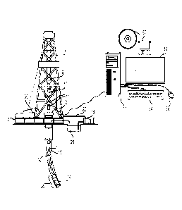
[0008] FIG. 1 depicts an elevation view of an LWD environment, according to
one or more
embodiments;
[0009] FIG. 2 depicts a schematic view of a deep resistivity logging tool, in
accordance
with one or more embodiments, according to one or more embodiments;
[0010] FIG. 3 depicts a flowchart view of a method a method to generate a
formation
model using formation data measured from the resistivity logging tool of FIG.
2, according to
one or more embodiments;
[0011] FIG. 4 depicts a graph view of inversion solutions to formation data,
according to
one or more embodiments;
2
CA 03057831 2019-09-24
WO 2018/208281 PCT/US2017/031604
[0012] FIG. 5 depicts a graph view of a histogram of formation boundary
positions,
according to one or more embodiments;
[0013] FIG. 6 depicts a graph view of the mean horizontal resistivity models
calculated
using the inversion solutions filtered with the histogram of FIG. 5, according
to one or more
embodiments; and
[0014] FIG. 7 depicts a graph view of a resistivity model with respect to
measurement
depth, according to one or more embodiments.
DETAILED DESCRIPTION
[0015] FIG. 1 shows one or more embodiments of an illustrative LWD
environment. A
drilling platform 2 supports a derrick 4 having a traveling block 6 for
raising and lowering a
drill string 8. A top drive 10 supports and rotates the drill string 8 as it
is lowered through the
wellhead 12. A drill bit 14 is driven by a downhole motor and/or rotation of
the drill string 8.
As bit 14 rotates, it creates a wellbore 16 that passes through various
formations. A pump 18
circulates drilling fluid 20 through a feed pipe 22, through the interior of
the drill string 8 to
drill bit 14. The fluid exits through orifices in the drill hit 14 and flows
upward through the
annulus around the drill string 8 to transport drill cuttings to the surface,
where the fluid is
filtered and recirculated.
[0016] The drill bit 14 is just one piece of a bottom-hole assembly 24 that
includes a mud
motor and one or more "drill collars" (thick-walled steel pipe) that provide
weight and
rigidity to aid the drilling process. Some of these drill collars include
built-in logging
instruments to gather measurements of various drilling parameters such as
location, is
orientation, weight-on-bit, wellbore diameter, etc. The tool orientation may
be specified in
terms of a tool face angle (rotational orientation), an inclination angle (the
slope), and
compass direction, each of which can be derived from measurements by
magnetometers,
inclinometers, and/or accelerometers, though other sensor types such as
gyroscopes may
alternatively be used. In one specific embodiment, the tool includes a 3-axis
fluxgate
magnetometer and a 3-axis accelerometer. As is known in the art, the
combination of those
two sensor systems enables the measurement of the tool face angle, inclination
angle, and
compass direction. Such orientation measurements can be combined with
gyroscopic or
inertial measurements to accurately track tool position.
[0017] The bottom-hole assembly 24 may include a device for measuring
formation
resistivity, a gamma ray device for measuring formation gamma ray intensity,
devices for
3
CA 03057831 2019-09-24
WO 2018/208281 PCT/US2017/031604
measuring the inclination and azimuth of the drill string 8, pressure sensors
for measuring
wellbore pressure, temperature sensors for measuring wellbore temperature,
etc. Also
included in bottom-hole assembly 24 is a telemetry sub that maintains a
communications link
with the surface. Mud pulse telemetry is one common telemetry technique for
transferring
tool measurements to surface receivers and receiving commands from the
surface, but other
telemetry techniques can also be used. For some techniques (e.g., through-wall
acoustic
signaling) the drill string 8 includes one or more repeaters 30 to detect,
amplify, and re-
transmit the signal. At the surface, transducers 28 convert signals between
mechanical and
electrical form, enabling a network interface module 36 to receive the uplink
signal from the
telemetry sub and (at least in some embodiments) transmit a downlink signal to
the telemetry
sub.
[0018] A computer system 50 located at the surface receives a digital
telemetry signal,
demodulates the signal, and displays the tool data or well logs to a user.
Although FIG. 1
depicts the computer system 50 as being hardwired to the telemetry system, it
should be
appreciated that the computer system 50 may be in wireless communication with
the
telemetry system. The computer system 50 may include a processor and a non-
transitory
machine-readable medium 53 (e.g., ROM, EPROM, EEPROM, flash memory, RAM, a
hard
drive, a solid state disk, an optical disk, or a combination thereof) capable
of executing
instructions. The processor of the computer system 50 may include one or more
processors
located at the surface or in the wellbore, such as integrated with the bottom-
hole assembly 24.
Software (represented in FIG. 1 as the non-transitory machine-readable medium
52) governs
the operation of the system 50. A user interacts with the system 50 and the
software 52 via
one or more input devices 54 and 55 and one or more output devices 56. In some
system
embodiments, a driller employs the system 50 to make geosteering decisions
(e.g., modifying
the wellbore trajectory or steering the drill bit 14) and communicate
appropriate commands to
the bottom-hole assembly 24 to execute those decisions. The computer system 50
is operable
to perform calculations or operations to evaluate the formation, identify
formation boundary
positions, and/or steer the drill bit 14 as further described herein.
[0019] The drillstring shown in FIG. 1 illustrates a directional drilling
operation, wherein
drilling is performed along a path or trajectory other than a straight
vertical path downward.
In at least some illustrative embodiments, the change in direction is achieved
using a "bent
sub," which is a tubular section along the drillstring near the drill bit that
is bent or curved.
The bend or curve may be fixed or variable, with the direction of the drilling
being
determined either by the bend alone, or by a combination of the bend and the
rotation of the
4
CA 03057831 2019-09-24
WO 2018/208281 PCT/US2017/031604
drillstring. For example, if a downhole motor is used to drive the drill bit
and a drillstring
with a fixed bent sub is maintained at a fixed azimuthal orientation, the
drill string will
gradually change direction towards the direction of the bend. If instead such
a drillstring is
rotated, drilling will progress along a line parallel to the drillstring
section above the bend and
about which the drill bit processes.
[0020] For drillstrings capable of varying the angle of the bent sub, the sub
is set to a desired
angle and direction while the drillstring is maintained at a desired fixed
azimuthal orientation,
with the drill bit being driven by the downhole motor. This is sometimes
referred to as "slide
drilling," as the drillstring slides through the wellbore without rotating. In
other drillstring
embodiments, the drillstring continues to be rotated and the angle of the bent
sub is
maintained by applying a force on the drillstring in a specific direction.
This causes the sub to
be pushed into the wellbore wall opposite the desired drilling direction to
create an angle
between the drillstring pipes and/or bottom-hole assembly units to either side
of the sub. Such
systems are sometimes referred to as rotary steerable systems.
[0021] Because of the angle change introduced by the above-described subs and
systems
used in directional drilling, and because of the bends produced in the
drillstring by the
resulting wellbore, logging tool subs located along the length of the
drillstring may be
oriented in different directions. This is particularly true for logging tools
utilized in deep
formation evaluation (i.e., tools wherein a transmitter antenna is separated
from a receive
antenna by at least 20 feet), as the transmit and receive antennas used in
such tools may be
housed in logging tool subs that are separated by larger distances (compared
to other logging
tools) in order to achieve the desired formation penetration of the
transmitted signals. The
greater the distance between the logging tool subs, the greater the
inclination and strike angle
differences may be between drillstring sections traversing a wellbore path
that is curved or
otherwise not a straight line. As used herein, the inclination angle of an LWD
tool sub that
houses an antenna is defined as the angle between a vertical z axis and the
drillstring's z axis
local to said antenna. The strike angle is defined as the angle between a
reference vector
normal to a vertical z axis and a projection onto a horizontal x-y plane of
the drillstring's z
axis local to the antenna.
[0022] FIG. 2 shows a schematic view of a deep resistivity logging tool 200,
in accordance
with one or more embodiments. The resistivity logging tool 200 may be included
with the
bottom-hole assembly 24 of FIG. 1 and includes two LWD sensor subs 202 and 206
at
different locations and orientations along a drillstring. A resistivity
logging tool receive
antenna 212 and a corresponding receive antenna position measurement device
222a are
CA 03057831 2019-09-24
WO 2018/208281 PCT/US2017/031604
housed within the LWD sensor sub 202, while a resistivity logging tool
transmit antenna 216
and a corresponding transmit antenna position measurement device 222b
(components of an
"at bit" instrument) are housed within the LWD sensor sub 206 and closer to
the drill bit 208.
The position measurement devices 222a, b locate the position of each
corresponding antenna,
which may be expressed, for example, in terms of each antenna's tilt angle (Or
and Ot relative
to the Zr and zt axes respectively; generally fixed and known), each antenna's
azimuthal
angle (a, and at relative to the x axis), each LWD tool sub's inclination
angle (Or and OA
and the distance d' between the antennas. Various methods may be used to
locate the antenna
positions (e.g., relative to a reference position on the surface. It should be
noted that although
the bent sub angles are typically less than five degrees, the illustration
shown has a much
more pronounced angles to better illustrate the effect of the angles on the
relative spatial
locations of the antennas, described in more detail below.
[0023] The resistivity logging tool 200 in communication with the computer
system 50 of
FIG. 1 is used to measure formation data, which is in turn used to evaluate
the formation
and/or determine a wellbore trajectory to produce formation fluids, such as
hydrocarbon
fluids including oil or gas. It should be appreciated that the resistivity
logging tool 200 is an
exemplary tool for measuring formation data and other suitable logging tools
may be used.
Also, other resistivity logging tools may employ different antenna
configurations to evaluate
the formation.
[0024] The formation data measured may be used to generate a resistivity model
of the
formation and determine the uncertainty of a parameter included in or
determined from the
formation data. A resistivity model may be used to identify boundary positions
between
formation layers and determine the wellbore trajectory to produce formation
fluids. The
uncertainty of a parameter indicates a range of suitable values for a
particular parameter such
as the uncertainty of resistivity values or boundary positions of formation
layers. For
instance, the uncertainty of a boundary position provides an indication of
where a formation
boundary may be located and the extent to which that formation boundary
position may vary.
As used herein, the uncertainty of a parameter refers to a range of suitable
values for the
parameter or a measure that is used to quantify a variation in the parameter
(e.g., standard
deviation). The parameter may include any one or any combination of a
horizontal resistivity,
vertical resistivity, conductivity, an anisotropy ratio, a boundary position
of formation layers,
and a formation dip.
6
CA 03057831 2019-09-24
WO 2018/208281 PCT/US2017/031604
[0025] FIG. 3 shows a flow chart of a method 300 to generate a formation model
using
formation data measured from the resistivity logging tool 200 of FIG. 2, in
accordance with
one or more embodiments. At block 302, the formation data is used to generate
DTBB
solutions using a DTBB inversion method. The inversion solutions may include
any one or
any combination of one-dimensional, two-dimensional, or three-dimensional
inversion
solutions. At block 304, the DTBB solutions are filtered to yield the DTBB
solutions that fit
best to the measured formation data. At block 306, a statistical distribution
of a formation
parameter (e.g., a histogram of the formation boundary positions) is generated
along one or
more depths of the subterranean earth formation to further filter the
inversion solutions based
on trends identified in the statistical distribution. At block 308, one or
more peaks within the
statistical distribution are identified to find the dominant trends in the
statistical distribution,
and the inversion solutions corresponding to the peaks are selected for
further processing. At
block 310, a formation model is generated using the selected inversion
solutions to efficiently
summarize the inversion solutions. At block 312, the formation model may be
used to
evaluate the formation to identify formation layers suitable for producing
formation fluids,
such as a hydrocarbon fluid. The formation model may also be used to develop a
wellbore
trajectory or steer the drill bit through or towards a formation zone suitable
for producing
formation fluids.
[0026] As a non-limiting example for block 302, to generate a resistivity
model of the
formation, multiple guesses are applied to a DTBB inversion method to provide
multiple
DTBB solutions that best fit to the measured formation data. The DTBB
inversions are run
with multiple random initial guesses with one or more formation layers. At
block 304, after
inversion, the DTBB solutions, which may include several hundred solutions,
are identified
by the extent of the misfit with the measured formation data. The DTBB
solutions that satisfy
a threshold (e.g., a minimal residual solution) may be identified for further
processing. The
DTBB solutions that fit best with the formation measurements are selected as
the final
solutions. The DTBB inversion and solution selection process is done
repeatedly on each
logging point or measurement depth of the resistivity logging tool to provide
a summarized
resistivity model based on the identified inversion solutions.
[0027] For example, FIG. 4 shows a graph view of the identified inversion
solutions, which
satisfy a certain misfit threshold relative to measured formation data,
according to one or
more embodiments. The inversion solutions in the graph satisfy a certain
misfit threshold
relative to formation data measured using the resistivity logging tool 200. As
shown, each
vertical stripe in the graph depicts the horizontal resistivity (Rh, ohm.m) as
function of true
7
CA 03057831 2019-09-24
WO 2018/208281 PCT/US2017/031604
vertical depth (TVD) and is an inversion solution for the same measurement
depth taken
using the resistivity logging tool. The horizontal resistivity value (Rh,
ohm.m) is depicted
using a contour scale according to the scale to the right of the graph. As
there are almost one
thousand inversion solutions for the same measurement depth, FIG. 4
demonstrates the
problem of evaluating the inversion solutions arising from measuring formation
data using
the deep resistivity logging tool 200¨namely the problem of evaluating a data
set comprising
hundreds of inversion solutions.
[0028] Referring to FIG. 3 at block 306, a statistical distribution of a
formation parameter
may be used to identify dominant trends among the inversion solutions and
further filter the
inversion solutions to generate a formation model as described in more detail
below. The
statistical distribution of a formation parameter may be generated using the
inversion
solutions identified at block 304. For example, the statistical distribution
may be a histogram
of a formation parameter among the identified solutions with respect to a true
vertical depth.
At block 308, once the statistical distribution is generated, one or more
peaks may be
identified in the histogram, and the inversion solutions corresponding to the
peaks may be
selected for further processing to generate a formation model as described in
more detail
below.
[0029] As a non-limiting example, a histogram of formation boundary positions
is
generated using the identified inversion solutions. To generate the histogram,
the formation
boundary positions among the inversion solutions are determined, and the
frequency of each
boundary position is counted at each true vertical depth (TVD). A formation
boundary
position may refer to a TVD where the difference between adjacent horizontal
resistivities
exceeds a threshold resistivity. A formation boundary position may also refer
to a TVD
where two different formation layers intersect (e.g., the boundary position
between shale and
sand). It should also be appreciated that the histogram used to filter
inversion solutions may
be generated based on the frequency of other suitable formation parameters,
including but not
limited to horizontal resistivity, vertical resistivity, conductivity,
anisotropy ratio, and/or
formation dip. As used herein, the term "histogram" may refer to a
representation of a
frequency distribution by means of rectangles whose widths represent class
intervals (e.g.,
boundary positions at TVDs) and whose areas are proportional to the
corresponding
frequencies. The term "statistical distribution" may refer to the underlying
data, which is used
to graphically represent a histogram, including but not limited to the class
intervals (e.g.,
boundary positions at TVDs or other suitable formation parameters at TVDs) and
the
frequencies corresponding to the class intervals.
8
CA 03057831 2019-09-24
WO 2018/208281 PCT/US2017/031604
[0030] FIG. 5 shows a graph view of an exemplary histogram 500 of formation
boundary
positions, according to one or more embodiments. The histogram 500 depicts the
frequency
of boundary positions determined at TVDs among the inversion solutions
identified at block
304. As shown, three peaks 502, 504, 506 correspond to prominent boundary
positions
among the inversion solutions. The peaks 502, 504, 506 (e.g., local maxima)
within the
histogram may be identified, and the inversion solutions corresponding to the
identified peaks
502, 504, 506 may be selected for further processing.
[0031] The peaks within the histogram indicate dominant trends for potential
formation
boundary positions in the formation. The peaks may be identified by finding
the boundary
position frequencies that exceed or satisfy a threshold value relative to
adjacent boundary
position frequencies. For example, the peak 502 may be identified based on its
frequency
value (about 500) exceeding a threshold (e.g., 10-30 % increase) relative to
the frequencies
(about 300) adjacent to the peak 502. As shown, the peak 502 increases in
frequency by about
60 % compared to the adjacent boundary frequencies. This increase in frequency
for the peak
502 relative to its adjacent frequencies satisfies the threshold, which may be
used to identify
peak 502.
[0032] The uncertainty of a formation boundary position can also be identified
by the width
508, 510 of a peak found in the histogram 500 (FIG. 5). The boundary position
uncertainty
includes but is not limited to the full peak width or a value less than the
full width of the peak
(e.g., a half width). If the mean horizontal resistivity includes sharp
contrasts in resistivity,
the boundary uncertainty may be relatively small as the inversion solutions
indicate the same
or similar boundary positions. On the other hand, if the mean horizontal
resistivity changes
gradually, the boundary uncertainty may be large indicating a large variation
in the boundary
position among the inversion solutions. The uncertainty of a parameter
indicates a range of
suitable values for a particular parameter such as the uncertainty of boundary
position. For
instance, the uncertainty of a boundary position provides an indication of
where a formation
position boundary may be located and the extent to which that formation
boundary position
may vary. As used herein, the uncertainty of a parameter refers to a range of
suitable values
for the parameter or a measure that is used to quantify a variation in the
parameter (e.g.,
standard deviation).
[0033] It should be appreciated that the histogram 500 is merely an exemplary
graphical
representation of the underlying measurement data used to identify trends
among the
inversion solutions. A statistical distribution comprising the class intervals
and the
frequencies corresponding to the class intervals used to generate a histogram
may also be
9
CA 03057831 2019-09-24
WO 2018/208281 PCT/US2017/031604
used to identify the peaks, peak widths, and inversion solutions corresponding
to the
identified peaks as previously discussed.
[0034] Once the inversion solutions corresponding to the peaks are selected, a
formation
model may be generated using the selected inversion solutions to evaluate the
formation,
determine a wellbore trajectory for a drill bit, and/or steer the drill bit to
a particular location
of interest identified in the formation model. The formation model may
indicate formation
layers or zones that are suitable for producing formation fluids, such as a
hydrocarbon fluid.
As such, the wellbore trajectory for the drill bit may be designed to advance
the drill bit
through a hydrocarbon producing zone. The drill bit may be steered using the
formation
model to stay within bed boundaries for the hydrocarbon producing zone.
[0035] At block 310, a model average scheme of the formation data may be used
to
summarize the results characterized by inversion solutions filtered with the
histogram. A
mathematical mean, including algebraic, geometric or harmonic mean:
n )1/n
1 1
H = ______________ n , H = xi _H = 1/n 1/xi
n Ei=i xi
may be applied to the selected solutions to calculate the formation model,
where H is the
mean value and {xi} are the parameter values for the selected solutions for a
particular
measurement depth. The various mathematical means provide different
interpretations of the
formation model. For example, the algebraic mean calculates the mean of the
resistivity in
ohm-m directly. The geometric mean calculates the mean on a logarithmic scale
of resistivity.
The harmonic mean calculates the mean of the conductivity and then converts
the mean
conductivity to resistivity. For an induction based resistivity LWD tool, the
harmonic mean is
usually used because the tool is sensitive to conductivity instead of
resistivity. Therefore, an
area with large conductivity may be highlighted when calculating the mean from
the
measurements of an induction logging tool.
[0036] FIG. 6 shows a graph view of the mean horizontal resistivity models 600
calculated
using the inversion solutions filtered with the histogram of FIG. 5, in
accordance with one or
more embodiments. Each vertical stripe of the resistivity model 600 is a
resistivity model
corresponding to the number of inversion solution(s) (x-axis) used to
calculate the mean.
Each vertical stripe of the resistivity models 600 also shows the mean
horizontal resistivity as
a function of true vertical depth (y-axis) with the resistivity scale to the
right of the graph.
The resistivity models 600 show the mean resistivity models calculated for the
same
measurement depth. Therefore, the leftmost resistivity model is the
resistivity model based on
CA 03057831 2019-09-24
WO 2018/208281 PCT/US2017/031604
a single inversion solution selected using the histogram, and the rightmost
resistivity model is
the mean resistivity based on thirty inversion solutions selected using the
same histogram.
FIG. 6 demonstrates that the mean resistivity value may vary based on the
number of
inversion solutions selected for calculation. FIG. 6 also demonstrates that
all the resistivity
models 600 identified a boundary position proximate to the TVD value of 2650
ft (808 m).
[0037] FIG. 7 shows a graph view of a resistivity model 700 with respect to
measurement
depth (x-axis), in accordance with one or more embodiments. As shown, for each
measurement depth, a mean resistivity model is calculated using the inversion
solutions
filtered from a histogram. The resistivity model 700 combines the mean
resistivity models
calculated at each measurement depth using the inversion solutions filtered
with a respective
histogram, and thus, each measurement depth represents the mean resistivity
model resulting
from performing blocks 302-310 of FIG. 3. Each vertical stripe shows the
formation
resistivity as a function of true vertical depth (y-axis) for a particular
measurement depth (x-
axis). The resistivity model 700 is shown as a contour plot of resistivity
with the resistivity
scale depicted to the right of the graph.
[0038] As shown, contrasts in resistivity (704 and 706) represent formation
boundary
positions between formation layers comprising different formation properties,
such as shale,
limestone, sandstone, gas-bearing sandstone, oil-bearing limestone, etc. The
boundary
positions of the formation layers identified in the formation model 700 can be
used to steer
the drill bit towards a suitable formation layer or identify the wellbore
trajectory 702 to
penetrate one or more formation layers for production, such as formation
layers suitable for
production of formation fluids. For instance, the wellbore trajectory 402 may
be identified to
advance predominantly between formation boundary positions identified based on
the
contrasts in resistivity 704 and 706.
[0039] At block 312, the boundary positions, which are identified using the
various graphs
(FIGS. 3-7) or averaged inversion solutions filtered using a histogram as
previously
discussed, may also be used to evaluate the formation, identify a wellbore
trajectory, and/or
steer a drill bit (e.g., the drill bit 14 of FIG. 1) through or toward a
formation layer suitable
for producing formation fluids. For example, a formation layer suitable for
producing
formation fluids may exist between the peaks 502 and 504 depicted in FIG. 5.
In addition to
the peaks 502 and 504 indicating the location of boundary positions, the
uncertainty of the
boundary positions are indicated by the widths 508, 510 of the peaks 502 and
504. The peak
widths 508, 510 indicate the range of TVDs where the boundary positions may
exist as well.
11
CA 03057831 2019-09-24
WO 2018/208281 PCT/US2017/031604
A drill bit may be steered or a wellbore trajectory may be developed to pass
between the peak
widths of peaks 502 and 504.
[0040] It should be appreciated that the system and methods described herein
provide a
solution particular to inversion methods used to determine formation
properties from deep
resistivity logging tools. Inversion methods using formation data from deep
resistivity
logging tools can provide hundreds of solutions at a single measurement depth
of the
resistivity logging tool. The method and system described herein filters the
inversion
solutions using a histogram to identify dominant trends among the inversion
solutions and
summarizes the filtered inversion solutions to evaluate the formation,
identify a wellbore
trajectory, and/or steer a drill bit for producing formation fluids.
[0041] In addition to the embodiments described above, many examples of
specific
combinations are within the scope of the disclosure, some of which are
detailed below:
Example 1: A system for evaluating a subterranean earth formation, comprising:
a logging tool comprising a sensor operable to measure formation data and
locatable
in a wellbore intersecting the subterranean earth formation;
a processor in communication with the logging tool and operable to:
calculate inversion solutions to the formation data, wherein each inversion
solution comprises values for a parameter of the formation,
generate a statistical distribution of the parameter along one or more depths
in
the subterranean earth formation using the inversion solutions,
identify peaks within the statistical distribution and select the inversion
solutions corresponding to the identified peaks,
generate a formation model using the selected inversion solutions; and
evaluate the formation using the formation model to identify formation layers
for producing a formation fluid.
Example 2: The system of example 1, wherein the logging tool comprises a
resistivity
logging tool operable to measure the resistivity of the formation.
Example 3: The system of example 1, wherein the processor is further operable
to generate
the formation model by calculating a mean of parameter values included in the
selected
solutions for a measurement depth of the logging tool.
12
CA 03057831 2019-09-24
WO 2018/208281 PCT/US2017/031604
Example 4: The system of example 1, wherein the parameter includes any one or
any
combination of horizontal resistivity, vertical resistivity, conductivity,
anisotropy ratio,
boundary position of formation layers, and a formation dip.
Example 5: The system of example 1, wherein the statistical distribution
comprises a
histogram of the parameter, wherein the processor is further operable to
generate the
histogram by determining formation boundary positions among the inversion
solutions and
determining the frequency of formation boundary positions at each true
vertical depth.
Example 6: The system of example 1, wherein the processor is further operable
to determine
the uncertainty of a parameter based on the statistical distribution by
identifying the width of
a peak in the statistical distribution.
Example 7: The system of example 1, wherein the inversion solutions comprise
any one or
any combination of a one-dimensional, a two-dimensional, or a three-
dimensional inversion
solution.
Example 8: The system of example 1, wherein the processor is further operable
to select
inversion solutions that satisfy a misfit threshold relative to the formation
data for generating
the statistical distribution.
Example 9: The system of example 1, wherein the processor is further operable
to calculate
the inversion solutions for formation data measured at a particular wellbore
depth.
Example 10: The system of example 1, wherein the processor is further operable
to identify
peaks within the statistical distribution based on a parameter frequency
exceeding a threshold
relative to an adjacent parameter frequency.
Example 11: A method of evaluating a subterranean earth formation, comprising:
calculating inversion solutions to formation data measured with a sensor of a
logging
tool located in a wellbore intersecting the formation, wherein the inversion
solutions comprise values for a parameter of the formation,
generating a statistical distribution of the parameter along one or more
depths in the
subterranean earth formation using the inversion solutions,
13
CA 03057831 2019-09-24
WO 2018/208281 PCT/US2017/031604
identifying peaks within the statistical distribution and selecting the
inversion
solutions corresponding to the identified peaks,
generating a formation model using the selected inversion solutions, and
evaluating the formation model to identify a formation layer to produce
formation
fluids.
Example 12: The method of example 11, wherein the logging tool comprises a
resistivity
logging tool operable to measure the resistivity of the formation.
Example 13: The method of example 11, wherein the formation model is generated
by
calculating a mean of parameter values included in the selected solutions for
a measurement
depth of the logging tool.
Example 14: The method of example 11, wherein the parameter includes any one
or any
combination of horizontal resistivity, vertical resistivity, conductivity,
anisotropy ratio,
boundary position of formation layers, and formation dip.
Example 15: The method of example 11, wherein the statistical distribution
comprises a
histogram of the parameter, and wherein generating the histogram comprises
determining
formation boundary positions among the inversion solutions and determining the
frequency
of formation boundary positions at each true vertical depth.
Example 16: The method of example 11, further comprising determining the
uncertainty of a
parameter based on the statistical distribution of formation boundary
positions.
Example 17: The method of example 11, wherein generating the statistical
distribution
comprises selecting inversion solutions that satisfy a misfit threshold
relative to the formation
data for generating the statistical distribution.
Example 18: The method of example 11, wherein identifying the peaks comprises
identifying
the peaks based on a parameter frequency in the statistical distribution
exceeding a threshold
value relative to an adjacent parameter frequency.
14
CA 03057831 2019-09-24
WO 2018/208281 PCT/US2017/031604
Example 19: A method of steering a drill bit in a subterranean earth
formation, comprising:
calculating inversion solutions to formation data measured with a logging tool
comprising sensors and located in a wellbore intersecting the formation,
generating a statistical distribution of a parameter of the formation along
one or more
depths in the subterranean earth formation using the inversion solutions,
identifying peaks within the statistical distribution and selecting the
inversion
solutions corresponding to the identified peaks,
calculating a mean of the parameter values included in the selected solutions
for a
measurement depth of the logging tool to generate a formation model, and
steering the drill bit through a formation layer identified using the
formation model.
Example 20: The method of example 19, wherein the logging tool comprises a
resistivity
logging tool operable to measure the resistivity of the formation; and the
parameter includes
any one or any combination of horizontal resistivity, vertical resistivity,
conductivity,
anisotropy ratio, boundary position of formation layers, and a formation dip.
[0042] This discussion is directed to various embodiments of the present
disclosure. The
drawing figures are not necessarily to scale. Certain features of the
embodiments may be
shown exaggerated in scale or in somewhat schematic form and some details of
conventional
elements may not be shown in the interest of clarity and conciseness. Although
one or more
of these embodiments may be preferred, the embodiments disclosed should not be
interpreted, or otherwise used, as limiting the scope of the disclosure,
including the claims. It
is to be fully recognized that the different teachings of the embodiments
discussed may be
employed separately or in any suitable combination to produce desired results.
In addition,
one skilled in the art will understand that the description has broad
application, and the
discussion of any embodiment is meant only to be exemplary of that embodiment,
and not
intended to suggest that the scope of the disclosure, including the claims, is
limited to that
embodiment.
[0043] Certain terms are used throughout the description and claims to refer
to particular
features or components. As one skilled in the art will appreciate, different
persons may refer
to the same feature or component by different names. This document does not
intend to
distinguish between components or features that differ in name but not
function, unless
specifically stated. In the discussion and in the claims, the terms
"including" and
"comprising" are used in an open-ended fashion, and thus should be interpreted
to mean
CA 03057831 2019-09-24
WO 2018/208281 PCT/US2017/031604
"including, but not limited to... ." Also, the term "couple" or "couples" is
intended to mean
either an indirect or direct connection. In addition, the terms "axial" and
"axially" generally
mean along or parallel to a central axis (e.g., central axis of a body or a
port), while the terms
"radial" and "radially" generally mean perpendicular to the central axis. The
use of "top,"
"bottom," "above," "below," and variations of these terms is made for
convenience, but does
not require any particular orientation of the components.
[0044] Reference throughout this specification to "one embodiment," "an
embodiment," or
similar language means that a particular feature, structure, or characteristic
described in
connection with the embodiment may be included in at least one embodiment of
the present
disclosure. Thus, appearances of the phrases "in one embodiment," "in an
embodiment," and
similar language throughout this specification may, but do not necessarily,
all refer to the
same embodiment.
[0045] Although the present invention has been described with respect to
specific details, it
is not intended that such details should be regarded as limitations on the
scope of the
invention, except to the extent that they are included in the accompanying
claims.
16