Note: Descriptions are shown in the official language in which they were submitted.
1
OBJECT RESPONSIVE ROBOTIC NAVIGATION AND IMAGING CONTROL SYSTEM
NOTICE OF COPYRIGHTS AND TRADE DRESS
[0001] A portion of the disclosure of this patent document contains
material which is
subject to copyright protection. This patent document may show and/or describe
matter which is
or may become trade dress of the owner. The copyright and trade dress owner
has no objection to
the facsimile reproduction by anyone of the patent disclosure as it appears in
the Patent and
Trademark Office patent files or records, but otherwise reserves all copyright
and trade dress rights
whatsoever.
BACKGROUND
[0002] Field
[0003] This disclosure relates to three-dimensional imaging and, more
particularly, to a
system for capturing images and shape characteristics for three-dimensional
objects for use in
incorporating the resulting three-dimensional models into virtual and
augmented reality
environments.
[0004] Description of the Related Art
[0005] There exist various systems and methods for three-dimensional
imaging of objects
and people. Most of those systems and methods rely upon complex, multi-camera
rigs in fixed
locations. In such rigs, pairs of cameras, or in some cases, single cameras,
are typically placed in
known locations that surround an object or objects to be captured. The cameras
are typically used
CA 3058747 2019-10-15
2
for photogrammetry, or in dual-camera setups stereography, to derive some of
the three-
dimensional characteristics of the object using known characteristics of the
imaged object. Or, in
stereography, by using two corresponding points on objects and relying upon a
known distance
between lenses, focal length and parallax to drive a distance to an object or
to different portions of
the same object from that known position within the rig. Typically, pairs of
cameras are placed at
known locations around the rig which surround the object or objects placed in
its center.
Preferably, a spherical rig is used, though other rig types rely upon bowl
structures or hedronic
structures.
[0006] These rigs are useful for modelling because they can capture high-
resolution, well-
lit images. The images can be compared using stereography to derive depth
data. Adjacent to the
camera pairs or near the camera pairs, depth sensors of various types may be
employed to provide
at least a cross-check or confirmation of depth information. The uniformity of
these types of rigs
is also helpful. Uniformity of distance from a center point of such rigs
enables the system to better
account for the overall characteristics of the object being captured. The
uniform lighting and
distance helps to make the resulting textures, derived from the captured
images, match one another
in both shadow (or lack thereof) and in calculating the appropriate shapes.
[0007] The primary downside of such structures is that they are fixed.
Typical spaces
within them are on the order of 3-8 feet in diameter at the largest points. As
most of these are
spherical or partially spherical, the height is typically the same as well.
There exist larger rig
structures, but they are less common and more expensive as one must set aside
the entire space,
and incorporate cameras across the entire space that are suitable for imaging
the objects within.
Many infrared depth sensors cease to be effective at approximately eleven feet
in distance from
CA 3058747 2019-10-15
3
the illuminator. Many depth sensors rely upon dense fields of light (e.g.
LIDRAR or infrared), and
as distance to an object grows, the resolution of such sensors, to the extent
they function at all,
decreases dramatically. In such a case, it is impossible to generate an
accurate, intricate depth map
and associated images for a complex, irregular physical object such as a
bicycle (e.g. wheels,
frame, spokes, etc.).
[0008] A better system that is capable of multiple resolutions and of
capturing large,
irregular objects with sufficient detail to create a detailed and accurate
three-dimensional model is
desirable.
DESCRIPTION OF THE DRAWINGS
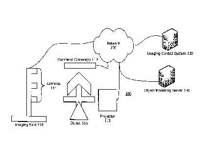
[0009] FIG. 1 is a system for three-dimensional object imaging.
[0010] FIG. 2 is a functional diagram of a system for three-dimensional
object imaging.
[0011] FIG. 3 is a block diagram of a computing device.
[0012] FIG. 4 is a flowchart for three-dimensional object imaging.
[0013] FIG. 5 is a perspective view of a three-dimensional object being
imaged using a
system for three-dimensional object imaging.
[0014] Throughout this description, elements appearing in figures are
assigned three-digit
reference designators, where the most significant digit is the figure number
and the two least
significant digits are specific to the element. An element that is not
described in conjunction with
a figure may be presumed to have the same characteristics and function as a
previously-described
element having a reference designator with the same least significant digits.
CA 3058747 2019-10-15
4
DETAILED DESCRIPTION
[0015] Description of Apparatus
[0016] Referring now to FIG. 1, a system 100 for three-dimensional
object imaging is
shown. The system 100 includes an imaging skid 110, overhead camera(s) 112, a
projector 113, a
set of cameras 114 an object 115, an imaging control system 120, and an object
modelling server
130, all interconnected by a network 150.
[0017] The imaging skid 110 is a mobile mount for a series of cameras
114 at various
heights. Preferably, sufficient independent cameras 114 are fixed on the
imaging skid 110 such
that 60% overlap in field of view between cameras for a given object being
imaged are present.
These cameras 114 are arranged at regular intervals up a tower, pillar, or
similar rig fixed to a
movable base. In some cases, the base of an imaging skid 110 may be fixed to a
ceiling or overhead
scaffold or independent wires (e.g. the follow cameras in professional
football games and other,
outdoor sporting events). In some cases, since the imaging skid 110 moves,
pairs of cameras may
not be required. Instead, a single camera may be moved a known distance
between images, and
images from that same camera may be used to generate stereographic pairs of
images.
[0018] The pairs of cameras may be more than pairs with triplets or full
360 cameras or
groups of cameras mounted in regular intervals along a tower or pillar. The
cameras 114 may
generate a series of images at fixed locations along a path around the object
115, or may generate
frame-by-frame video including thousands of images. The path may intentionally
choose a uniform
distance (e.g. be circular) because for some objects, that may provide
additional data useful for
photogrammetry. In other cases, different paths (e.g. square or t-shaped or
with several paths both
CA 3058747 2019-10-15
5
close to the object and more distant from the object) may be used, dependent
upon the type of
photogrammetry used or other available data. Either may be used to generate
the eventual three-
dimensional model and one may be used over the other for quicker or better
object modelling or
to conserve storage space. The imaging skid 110 may also incorporate LIDAR,
infrared depth
sensors, or other point cloud, light-based or sound-based depth sensors.
[0019] Of import for the purposes of the imaging skid 110 discussed
herein, the skid 110
must be capable of some kind of independent, or self-guided, movement under
the control of the
imaging control system 120 or of its own onboard computing device. In the most
basic setup, the
imaging skid may be a flat or largely flat, weighted base fixed on three or
more wheels, with some
of those wheels capable of propelling (e.g. fixed to a motor or similar
conveyance) the imaging
skid 110 around an object to be imaged. Some of the wheels may be turnable or
alterable under
the control of the imaging control system 120 such that the imaging skid 110
may move about an
object in a circular fashion.
[0020] In other cases, as indicated above, the imaging skid may be
movable as fixed to a
series of wires hanging over the object to be imaged, with the wheels
maintaining and altering the
imaging skid 110's position on the wires. In other cases, the imaging skid 110
may be designed in
such a way to hang from an overhead scaffold or ceiling and move about using
rails.
[0021] In still other cases, the imaging skid 110 may be fully self-
contained and may
operate as a flying drone. In such a case, a tower or pillar of cameras and
depth sensors may not
be necessary. Instead, a flying drone may move in a pattern about an object to
be imaged at a fixed
distance multiple times at different heights relative to the ground. In such a
way, the flying drone
CA 3058747 2019-10-15
6
imaging skid 110 may gather a similar set of images and depth information to
generate a three-
dimensional model as described herein with respect to the imaging skid 110
that is fixed on the
ground or a ceiling or scaffold.
[0022] In whatever form the imaging skid 110 takes, it may also
incorporate one or more
downward-facing or non-object-facing cameras for tracking movement of the
imaging skid 110 as
it images an object 115. For example, a downward-facing camera may track a
path physically
drawn on the floor or an upward-facing one may track a path drawn on a
ceiling. A downward-
facing camera may work with the overhead camera(s) 112 to move the skid from
computer-
readable symbol to computer-readable symbol (e.g. a QR code) on the floor or
ceiling in locations
from which an operator desires to capture a series of images or along a path
(e.g. between two
codes) where an operator wishes to capture a series of images. In another
alternative, an outward-
facing depth sensor, such as an RGB/RGB-D/D sensor, may generate depth data to
keep the
imaging skid 110 at a fixed distance from an outer wall. This depth sensor
data may utilize
simultaneous localisation and mapping (SLAM) to guide the imaging skid 110 in
a desired (or
dynamic) path around the object 115. Alternatively, an inward-facing depth
sensor may generate
data used to keep the imaging skid 110 at a fixed distance from the object 115
or from a center-
point (e.g. a pillar) on which the object 115 is mounted or to which it is
fixed. In this way, the
imaging skid 110 may be maintained at known locations and/or distances from
which stereography
may be used to generate the eventual three-dimensional model of the object
115.
[0023] The overhead camera(s) 112 are video and, potentially, depth
camera(s) that view
the entirety of the object 115 and the imaging skid 110 as the imaging skid
110 moves around the
object 115 to provide guidance and additional information to the imaging
control system 120 (or
CA 3058747 2019-10-15
7
imaging skid 110) to direct its movements relative to the object 115. The
overhead camera(s) 112
may be ordinary RGB video cameras, the resulting images from which computer
vision techniques
are applied to enable the resulting data to determine the location and general
characteristics of the
object 115, the location and orientation of the imaging skid 110 relative to
the object 115, the
overall path or desired path for the imaging skid 110 as it captures images of
the object 115, and
to provide any desired adjustments to the imaging control system 120 so that
the imaging skid
110's path may be altered or updated as needed.
[0024] A projector 113 may be optionally included in some cases. A
projector may be a
part of a depth sensor (discussed above) such as a LIDAR or infrared sensor.
Or, a projector 113
may be independently provided. The projector 113 may project a design, shape
or, light of a known
type onto an object being imaged. Cameras, such as cameras 114 viewing that
projected design
may use photogrammetry to extrapolate features of the design. For example, at
a specific distance,
a projection of a cross-hatched pattern on an object is known, if the object
is flat, to have a certain
width and height. That information can be used to derive the overall
parallelism of an object's face
to the cameras 114, the angle at which a given face is presented, and to
calculate curves of that
object and subsequent depths at different points on the object. A projector
113 is particularly useful
for objects lacking in significant features or with long, continuous faces
(e.g. a tent or canoe).
[0025] The object 115 is any object being imaged. For purposes of this
disclosure, irregular
objects, such as bicycles or kayaks, are discussed because they present the
most difficult
characteristics for traditional three-dimensional imaging systems to capture,
but that are more
suitable for imaging in the present system.
CA 3058747 2019-10-15
8
100261 The imaging control system 120 is a computing device (FIG. 3)
that operates to
control the movement of the imaging skid 110 as it images an object 115 and to
store images
created by the imaging skid 110 as it generates those images. For example, the
imaging control
system 120 may control the movement of the imaging skid 110 so that it is self-
guided, and does
not require guidance from an operator or external markers or guides (e.g.
lines on a floor or ceiling
or QR or similar computer-readable codes). The imaging control system 120 is
shown as separate
from the imaging skid 110, but it may in some cases be fully or partially
incorporated into the
imaging skid 110 itself. For example, some of the guidance processes that
direct the location of
the imaging skid 110 may be integrated into the imaging skid 110 itself.
100271 The object modelling server 130 is a computing device (FIG. 3)
that converts the
generated stereoscopic images, video, and depth data at known distances from
the object 115 into
a complete three-dimensional model of the object 115. The object modelling
server 130 may or
may not be a part of the overall system 100. Specifically, the object
modelling server 130 may take
place as a part of the system 100 such that the output to another is the
completed three-dimensional
model of the object 115. In other cases, for example, cases where a customer
or other wishes to
generate the model themselves, the output may be the series of uniform images
or video and depth
data that may be converted into a three-dimensional model. In those cases, the
object modelling
server 130 may be operated by the customer or another.
100281 The network 150 is communications hardware and associated
protocols that enable
communication between the various components. This network 150 may be or
include the intemet,
Ethernet, 802.11x wireless networks, Bluetooth, and may in some cases include
more direct
CA 3058747 2019-10-15
9
connections such as USB, or other wired connections (particularly for
generation of large imaging
data by the cameras 114 for storage on the imaging control system 120).
[0029] FIG. 2 is a functional diagram of a system 200 for three-
dimensional object
imaging. The system 200 includes the same imaging skid 210, overhead camera(s)
212, imaging
control system 220, and object modelling sever 230 shown in FIG. 1. In FIG. 2,
sub-functions of
those components are also shown.
[0030] The imaging skid 210 includes a camera rig 214, a depth-sensing
rig 215, tracking
camera(s) 216, motion systems 218, and data storage 219. The camera rig 214 is
described above.
It may be a single camera, or camera pairs, or may be a set of three or more
cameras with
overlapping fields of view. The camera rig 214 preferably includes video
cameras capturing many
frames of video per second so that multiple sets of images may be used,
throughout the overall
shooting process, to generate the eventual three-dimensional model. In
addition, the capture of
many frames enables the model integration system 236 (discussed below) to
compensate for any
problems in some of the frames or images. The camera rig 214 captures images
of an object to be
modelled from many perspectives so that the eventual three-dimensional model
may be created.
[0031] The depth-sensing rig 215 may be or include the camera(s) of the
camera rig 214.
However, the depth-sensing rig 215 may also include depth sensors of various
types. The most
common are light-based sensors such as L1DAR or infrared sensors such as those
used in the
Microsoft Kinect system. Though, other point-cloud systems and sound-based
(e.g. eco-
location) exist as well. The sensors used in the depth-sensing rig 215
typically have a fixed
resolution. As a result, they can only function from certain distances. For
example, infrared-based
CA 3058747 2019-10-15
10
sensors operate best at a distance of less than 20 feet and indoors.
Otherwise, they are washed-out
by bright lights or the sun. However, at those distances, their resolution is
quite good for accurately
representing, even objects of small variations in depths. In contrast, LIDAR
resolution is quite
poor, with only hundreds or thousands of points in a point cloud, but its
operating distance is quite
large. It can work outdoors and across more than one hundred feet of distance
in most cases. To
compensate, moving either the LIDAR or infrared systems to various depths from
the object being
imaged can dramatically increase accuracy. Then, resulting three-dimensional
models can be
overlaid one on another with the one captured "closer" to the object taking
precedence either
entirely, or merely to add more details (e.g. the spokes of a bicycle may not
be visible to infrared
depth sensors at 10 feet distance, but may be at 2 feet).
100321
The tracking camera(s) 216 are used to assist in keeping the imaging skid 210
on a
predetermined course. Preferably, this course is at a set distance for all
images of an object for at
least one full revolution around that object. In this way, the depth may be
more accurately
calculated for the entire object and, thus, its dimensional characteristics
more accurately mapped.
The tracking camera(s) 216 may rely upon paths laid out on the ground or the
ceiling, QR or other
machine-readable codes placed at various intervals along the course, or upon a
set track laid-out
before imaging occurs. In some cases, tracking camera(s) 216 may merely
incorporate depth data
to keep the imaging skid 210 at a fixed distance from a known center point
such as a rack or pole
or other mount for the object. A single computer-vision readable object may be
hung at a center
point for a desired object imaging process (e.g. by a string hanging from the
ceiling), and the
tracking camera(s) 216 may use that object to continuously adjust the pathing
of the imaging skid
CA 3058747 2019-10-15
11
210 as it moves about an object being imaged so as to maintain the desired
distance or distances
(if multiple circuits of the object are taken).
[0033] The motion systems 218 are motors or engines, and steering
mechanisms that move
the imaging skid 210 from place to place around the object. As indicated
above, these may be
wheels and motors powered by electricity or batteries, or may be wires, or
propellers that move a
hanging or flying imaging skid 210 around the object.
[0034] The data storage 219 is simply non-transitory storage for the
images and depth data
created by the camera rig 214, the depth sensing rig 215, and the tracking
camera(s) 216. The data
storage 219 is temporary in the sense that the data storage 219 may be
emptied, either manually
by transmission to another device (e.g. the object modelling server 230) or
automatically by
transmission to the imaging control system 220 as the data is created or at
fixed intervals or as a
complete circuit of an object being imaged is completed.
[0035] The overhead camera(s) 212 may generate overhead imaging data that
is used,
alone or in conjunction with the tracking camera(s) 216 to guide the motion
systems 218 of the
imaging skid 210 as it traverses around an object being imaged. Likewise,
projector 213 (which
may in fact be multiple projectors or may be mounted to the imaging skid 210)
projects images,
visible or invisible to the naked eye, that may be used in photogrammetry.
[0036] The imaging control system 220 includes a data interface 222, data
integration 224,
a skid controller 226, manual direction 228, and data storage 229.
[0037] The data interface 222 enables the imaging control system 220 to
receive or request
data from the imaging skid 210. The data may include image data, depth data,
and/or motion and
CA 3058747 2019-10-15
12
tracking data for the skid 210. The data interface 222 may also enable the
imaging control system
220 to send instructions such as pathing instructions, and movement parameters
to the imaging
skid 210.
[0038] The data integration 224 system may be used to simultaneously
integrate data from
the tracking camera(s) 216 and the overhead camera(s) 212 or other sources to
determine from
moment to moment the location and pathing for the imaging skid 210. The data
integration 224
system may operate to combine data from those various sources into data that
may be used by the
imaging control system 220 to control the skid 210.
[0039] The skid controller 226 is software that directs the movement of
the skid 210. The
skid controller 226 may provide an overall path and distance parameter and
allow the skid 210
itself to constantly determine its own path to accomplish the desired result,
such that the skid 210
is self-guided. Alternatively, the skid controller 226 may operate on a moment
to moment basis to
provide ongoing instructions and motion parameters for the skid 210. This will
be based upon the
synthesized data generated by the data integration 224.
[0040] The manual direction 228 may enable an operator of the imaging
control system
220 to take control of the imaging skid 210 in a manual mode, essentially
controlling movement
of the skid by hand using a video game controller, a series of commands, or
other methods.
[0041] Data storage 229 may store data pertaining to the images generated
by the overhead
camera(s) 212 and the tracking camera(s) 216. Data storage 229 may also store
data generated by
the camera rig 214 and the depth-sensing rig 215 as well as data regarding the
distance or distances
at which the imaging skid 210 circled the object as it was being imaged. This
data may be used
CA 3058747 2019-10-15
13
both in controlling pathing of the skid 210 but also by the object modelling
server 230 in generating
the eventual three-dimensional model of the object.
[0042] The object modelling server 230 includes an image database 232, a
depth database
234, a model integration system, and data storage 239.
[0043] The image database 232 is a database of image data generated
through analysis of
the image data generated by the imaging skid 210 and stored in the data
storage 239. The depth
database 234 is similar, but it stores depth data that is the result of
analysis of the depth data
captured by the imaging skid 210.
[0044] The model integration system 236 takes the two sources of data for
a given object
that are generated by the imaging skid 210 and generates a three-dimensional
model of the object.
As will be discussed more fully below, both the images and the depth data may
be captured at
multiple distances from the object. Various algorithms may be used for object
modelling by the
model integration system 236. Once created, the three-dimensional model may be
stored in data
storage 239 so that it may be shared or used for other purposes (e.g. inserted
into a VR or AR
environment or used in a video game engine for various purposes).
[0045] Turning now to FIG. 3, a block diagram of a computing device 300
is shown. The
computing device 300 may be representative of the server computers, client
devices, mobile
devices and other computing devices discussed herein. The computing device 300
may include
software and/or hardware for providing functionality and features described
herein. The
computing device 300 may therefore include one or more of: logic arrays,
memories, analog
circuits, digital circuits, software, firmware and processors. The hardware
and firmware
CA 3058747 2019-10-15
14
components of the computing device 300 may include various specialized units,
circuits, software
and interfaces for providing the functionality and features described herein.
[0046] The computing device 300 may have a processor 310 coupled to a
memory 312,
storage 314, a network interface 316 and an I/O interface 318. The processor
310 may be or include
one or more microprocessors and application specific integrated circuits
(ASICs).
[0047] The memory 312 may be or include RAM, ROM, DRAM, SRAM and MRAM,
and
may include firmware, such as static data or fixed instructions, BIOS, system
functions,
configuration data, and other routines used during the operation of the
computing device 300 and
processor 310. The memory 312 also provides a storage area for data and
instructions associated
with applications and data handled by the processor 310. As used herein, the
word memory
specifically excludes transitory medium such as signals and propagating
waveforms.
[0048] The storage 314 may provide non-volatile, bulk or long-term
storage of data or
instructions in the computing device 300. The storage 314 may take the form of
a disk, tape, CD,
DVD, SSD, or other reasonably high capacity addressable or serial storage
medium. Multiple
storage devices may be provided or available to the computing device 300. Some
of these storage
devices may be external to the computing device 300, such as network storage
or cloud-based
storage. As used herein, the word storage specifically excludes transitory
medium such as signals
and propagating waveforms.
[0049] The network interface 316 is responsible for communications with
external devices
using wired and wireless connections reliant upon protocols such as 802.11x,
Bluetooth ,
CA 3058747 2019-10-15
15
Ethernet, satellite communications, and other protocols. The network interface
316 may be or
include the interne.
[0050] The I/O interface 318 may be or include one or more busses or
interfaces for
communicating with computer peripherals such as mice, keyboards, cameras,
displays,
microphones, and the like.
[0051] Description of Processes
[0052] FIG. 4 is a flowchart for three-dimensional object imaging. The
flow chart has both
a start 405 and an end 495, but the process is cyclical in nature. As an
object is being imaged or
as multiple objects are being imaged, the steps of the flowchart may take
place many times or at
various distances from the same object. Multiple passes through the flowchart
may improve
resolution or accuracy of the resulting three-dimensional model.
[0053] Following the start 405, the first step is to install the
camera(s) on the imaging skid
410. This step includes the physical installation of the camera(s) on the
imaging skid, but also
includes any calibration. For example, the distances between the lenses of
camera pairs may be
calibrated so that the depth data from stereography may be accurately measured
if sterography is
used. If photogrammetry is used, this step is optional, though some
calibration of the projected
matrices, or other images, and their relationships to the cameras may take
place. The distances
between cameras on the camera rig may also be useful to get a second set of
stereography data
points. The depth sensors may also require calibration to ensure they are
accurately measuring
depth.
CA 3058747 2019-10-15
16
[0054] The skid must also be set up in such a way that it is capable of
movement. This may
be placing the skid on wheels, setting up the scaffold or wall mounts, or any
wires for the imaging
skid.
[0055] Next, the operator must use the imaging control system, and
potentially physical
alteration to the environment, to set a path or imaging distance for the skid
at 420. This may be as
simple as instructing the imaging control system to image a given object at a
distance of 10 feet, 4
feet, and 2 feet from the object. In an automated system, a center point may
be determined (e.g.
using a physical marker at a center point or over the object) and the imaging
control system may
automatically instruct the imaging skid in maintaining those distances and
creating appropriate
images.
[0056] In some cases, it may be simplest to draw a physical path or a set
of physical paths
on the ground in the form of a white line that the tracking cameras can follow
along the ground.
Alternatively, a series of QR or similar codes may be used to set the path at
420. In still other
cases, the imaging skid may be placed on a physical rail system or other
system that ensures a
specific pathing for the imaging skid at 420.
[0057] Next, the imaging skid begins imaging on path or at desired
distance at 430. At this
phase, the imaging skid moves around the object being imaged, while being
careful to use the path
or imaging distance to maintain the known, desired distance. In this way,
images at the same depth
may be compared to generate a more accurate three-dimensional model for the
object.
[0058] Next, a determination is made at 435 whether there are additional
paths or distances
at which the imaging system is to operate. Specifically, for objects of
irregular characteristics, e.g.
CA 3058747 2019-10-15
17
the spokes of a bicycle or a kayak, certain distances may not be sufficient to
generate an accurate
three-dimensional model from the resulting data. For other objects, e.g. a
surfboard, a single pass
at a set distance may be sufficient. The operator may require or suggest, or
the system may
automatically perform, imaging at various distances to improve the accuracy of
the resulting three-
dimensional model.
[0059] If additional paths or distances are desired ("yes" at 435), then
the imaging at that
path or distance are repeated at 430 and another determination regarding
additional paths or
distances is made at 435.
[0060] If no additional paths or distances are desired ("no" at 435),
then the imaging
process completes at 440. This may include a step of storing the generated
image and depth data,
and may include transmission of that data to a remote computing device or
server, such as the
imaging control system 220 or the object modelling server 230 (FIG. 2).
[0061] Next, the object modelling server 230 (FIG. 2) may be used to
generate a three-
dimensional model at 450. As indicated above, there are various methods for
performing this
function. The most basic involves stereography reliant upon multiple sets of
images of the same
object taken at the same distance, but from different perspectives. That data
alone may be used to
create a baseline three-dimensional model. Then, the data may be refined or
added to using depth
data gathered at the same time. Alternatively, the depth data may be used as a
baseline because it
is more accurate, but the image data and stereography used only to confirm the
depth of various
aspects of the object. The image data may also be used to generate so-called
textures for the
eventual three-dimensional model that match the actual appearance of the
object. The images may
CA 3058747 2019-10-15
18
be "wrapped" around the object, with the images edited to provide the best
perspective for objects
with a front-on view from the camera depending on where the cameras were when
the photographs
were taken. In this way, many images may be stitched together to form a
texture for a given model.
Other methods rely upon integration of multiple passes around the same, fixed,
object with one or
more passes capturing image data representative of the object's texture, with
other passes
representative of the objects depth from the camera (from which to derive the
physical shape of
the object). Or, those passes may be simultaneous with one another, with
images taken with and
without projections visible. Other data, e.g. infrared data, is invisible to
RGB cameras and may be
captured simultaneously with texture capture. Various methods exist for
integrating the data
captured by the proposed method and generating three-dimensional images and
models.
[0062] Next the three-dimensional model is stored and/or transmitted to a
desired location
for use at 460. At this stage, the resulting model may be integrated into an
augmented reality or
virtual reality environment or a game engine for virtually any purpose. Some
typical purposes may
be to integrate real-world objects into game or virtual reality or augmented
reality environments
for purposes of additional immersive experience within those environments.
Other purposes may
include online advertising or advertising for real-world products in three-
dimensional
environments such as VR, AR and video games.
[0063] The process then ends at 495.
[0064] Referring now to FIG. 5, a perspective view of a three-dimensional
object being
imaged using a system 500 for three-dimensional object imaging. This
perspective shows the
overhead camera(s) 512 with their full field perspective 527 of the entirety
of the environment in
CA 3058747 2019-10-15
19
which the imaging skid 510 is moving to capture images of the object 515 using
the cameras 514.
A series of different paths 521, 522, and 523 may be designated at different
distances from the
object 515. Though shown as circular, other paths may be used as well. As
discussed above, this
is to enable the object's characteristics, particularly fine details of the
three-dimensional
characteristics of the object, to be imaged and detected by depth sensors on
the imaging skid 510.
[0065] The paths 521, 522, and 523 are shown as concentric circles of
different radii that
are physically drawn on the ground around the object 515. However, a series of
QR codes 525 may
also be used or used instead. Alternatively, as discussed above, the depth
sensors on the imaging
skid 510 may maintain set distances from a center point. The overhead
camera(s) 512 and projector
513 may aid in this process. In still other cases, no path may be visibly
defined at all, instead
relying wholly upon depth sensors and/or overhead camera(s) 512 and may move
irregularly to
ensure the best overall model is created.
[0066] Closing Comments
[0067] Throughout this description, the embodiments and examples shown
should be
considered as exemplars, rather than limitations on the apparatus and
procedures disclosed or
claimed. Although many of the examples presented herein involve specific
combinations of
method acts or system elements, it should be understood that those acts and
those elements may
be combined in other ways to accomplish the same objectives. With regard to
flowcharts,
additional and fewer steps may be taken, and the steps as shown may be
combined or further
refined to achieve the methods described herein. Acts, elements and features
discussed only in
CA 3058747 2019-10-15
20
connection with one embodiment are not intended to be excluded from a similar
role in other
embodiments.
100681 As
used herein, "plurality" means two or more. As used herein, a "set" of items
may include one or more of such items. As used herein, whether in the written
description or the
claims, the terms "comprising", "including", "carrying", "having",
"containing", "involving", and
the like are to be understood to be open-ended, i.e., to mean including but
not limited to. Only the
transitional phrases "consisting of' and "consisting essentially of",
respectively, are closed or
semi-closed transitional phrases with respect to claims. Use of ordinal terms
such as "first",
"second", "third", etc., in the claims to modify a claim element does not by
itself connote any
priority, precedence, or order of one claim element over another or the
temporal order in which
acts of a method are performed, but are used merely as labels to distinguish
one claim element
having a certain name from another element having a same name (but for use of
the ordinal term)
to distinguish the claim elements. As used herein, "and/or" means that the
listed items are
alternatives, but the alternatives also include any combination of the listed
items.
CA 3058747 2019-10-15