Note: Descriptions are shown in the official language in which they were submitted.
SYSTEMS AND METHODS FOR ESTIMATION OF BUILDING FLOOR AREA
BACKGROUND
Technical Field
This invention is in the field of building size estimation, and in
particular, building floor area estimation.
Description of the Related Art
Building floor area is used throughout the construction, real
estate, insurance and finance industries. For example, the square footage
measurement of a building is used as a main factor in quickly determining the
market value of real estate, estimating costs of materials to repair or
replace
flooring and make other improvements or modifications to the entire building.
Thus, accurate floor area measurements are instrumental in these calculations.
Current methods of measuring floor area often involve a person having to visit
the building and manually measure particular dimensions within the building,
or
by referring to original plans or blueprints of the building. Manually
measuring
the dimensions for verification of building floor area is costly and original
plans
for the building may be unavailable or out of date. Therefore, accurate
methods
for estimating and verifying floor area, and for using such floor area
estimation
and verification in the construction, real estate, insurance and finance
industries, which avoid these drawbacks are desirable.
SUMMARY OF THE INVENTION
A subset of building floor area, referred to as total living area
(TLA) is used by insurance underwriters (Underwriters) as one component of
assessing whether to insure a property, what kind of insurance to provide and
at what premium rate. Underwriters also factor in overall condition of the
property to be insured which includes, among other things, a visual assessment
CA 3071512 2020-02-05
1
of the number of buildings such as detached garages and barns on the
property; building features such as roofs, chimneys, siding, skylights,
windows
and doors; items on the property such as recreational vehicles, abandoned
cars, and animal pens; and distances from the property to features such as
steep ground slopes, water hazards, greenbelt areas, and fire hydrants. In
addition, Underwriters may also factor in data from government records
pertaining to the property and buildings on it. Current methods of acquiring
this
information often involve a person having to visit the property and manually
measure and inspect the property, or having to visit a location to view
original
plans or blueprints of the building. Manually measuring total living area
(TLA)
and manually evaluating property condition is costly, particularly given the
high
demand for underwriting new policies or reassessing old policies. Therefore
accurate methods for estimating TLA and evaluating property conditions that
avoid these drawbacks are desirable.
In one embodiment, a floor area measurement system receives a
first and a second aerial image of the building, each of the aerial images
providing a different view of the roof of the building. The system correlates
the
first aerial image with the second aerial image to generate a three-
dimensional
model of the roof that includes a plurality of planar roof sections that each
have
a corresponding slope, area, and edges. An adjusted roof model is generated
by adjusting a slope of the planar roof sections in the three dimensional
model
of the roof to substantially zero. This may be performed in a variety of
manners, including, in one embodiment, removing particular roof features from
the model that would not be present in a flat roof, namely a roof with zero
slope.
For example, one step is to remove ridge lines or other features
distinguishing
individual planar roof sections resulting in a virtual fusing of the
individual roof
sections in the model into one flat roof. This may be performed instead of or
in
addition to adjusting a slope parameter or variable of each roof section
within
the roof model to zero. In other embodiments, this step may be performed with
just one initial aerial image of the building showing a substantially
orthogonal
CA 3071512 2020-02-05
2
view of the building since roof pitch need not be determined and can be
assumed to be zero.
The system generates the estimated floor area measurement of
the building based on the calculated estimated total roof area of the roof
after
the roof model has been adjusted. This is based on a correlation between the
size of the building roof and the size of the building. Typically, the floor
area of
a single full floor of the building is roughly the size of the roof of the
building if
the roof were assumed to be flat, namely a slope of zero. This will turn the
roof
into another floor in the virtual space. With additional adjustments to the
roof
area measurements to account for multiple floors, roof overhang, wall width,
internal building features such as walls and staircases, and/or obstructed
views
of the building in the aerial image(s), etc., an even more accurate floor area
estimation is generated.
In one embodiment, a floor area measurement estimation system
may be a system integrated with a roof estimation system or other system that
provides roof measurements. In other embodiments, the roof area
measurements may be provided by an external source, system or entity, or may
be input manually by an operator of the floor area measurement estimation
system. Various received roof measurements may often correspond closely to
external dimensions of the building such as the width and length of the
building
and/or lengths of exterior walls or sections of exterior walls of the
building.
In another embodiment, the output of the floor area measurement
may take the form of an electronic or printed report that includes, but is not
limited to geocoding information of the property, images of the property from
one or more views, diagrams showing the area and dimensions of living area
on different floors.
One embodiment is a computing system for generating an
estimated floor area measurement, the computing system comprising: a
memory; a floor area measurement estimation module that is stored on the
memory and that is configured, when executed, to: receive one or more aerial
images of a roof of a building including a substantially top-down image of the
CA 3071512 2020-02-05
3
roof; and generate, based at least in part on the received aerial images, an
estimated floor area measurement of the building.
One embodiment is a computer-implemented method for
generating an estimated floor area measurement, the method comprising:
receiving one or more aerial images of a roof of a building including a
substantially top-down image of the roof; using the substantially top-down
image of the roof to calculate an estimated total roof area of the roof
assuming
each section of the roof has no slope; and generating the estimated floor area
measurement of the building based on the calculated estimate total roof area
of
the roof.
One embodiment is a computer-readable medium whose contents
enable a computing system to generate an estimated floor area measurement,
by performing a method comprising:
receiving one or more aerial images of
a roof of a building including a substantially top-down image; using the
substantially top-down image to calculate an estimated total roof area of the
roof assuming each section of the roof has no slope; using the one or more
aerial images of the roof to determine the number of floors of the building
that
are under the roof; and generating, based at least in part on the estimated
total
roof area measurement and the number of floors that are under the roof, an
estimated floor area measurement of the building.
One embodiment is a computing system for generating a risk
management report, the computer system comprising: a memory; a risk
management report module that is stored on the memory and that is
configured, when executed, to: receive features and conditions data about a
property; receive risk management criteria for the property; and generate,
based at least in part on the received features and conditions data and risk
management criteria, a risk management report for the property.
One embodiment is a computer-implemented method for
generating a risk management report, the method comprising: receiving
features and conditions data about a property; receiving risk management
criteria for the property; and generating, based at least in part on the
received
CA 3071512 2020-02-05
4
features and conditions data and risk management criteria, a risk management
report for the property.
One embodiment is a computer-readable medium whose contents
enable a computing system to generate an estimated floor area measurement,
by performing a method comprising: receiving
features and conditions data
about a property; receiving risk management criteria for the property; and
generating, based at least in part on the received features and conditions
data
and risk management criteria, a risk management report for the property.
One embodiment is a computing system for generating a risk
management report, the computing system comprising: a memory; a risk
management report module that is stored on the memory and that is
configured, when executed, to: receive features and conditions data about a
property; receive risk management criteria for the property; receive one or
more
aerial images of a roof of a building on the property including a
substantially
top-down image of the roof; generate, based at least in part on the received
aerial images, an estimated floor area measurement of the building; and
generate, based at least in part on the received features and conditions data,
estimated floor area measurement of the building and risk management criteria,
a risk management report for the property.
One embodiment is a computer-implemented method for
generating a risk management report, the method comprising: receiving
features and conditions data about a property; receiving risk management
criteria for the property; receiving one or more aerial images of a roof of a
building on the property including a substantially top-down image; using the
substantially top-down image of the roof to calculate an estimated total roof
area of the roof assuming each section of the roof has no slope; using the one
or more aerial images of the roof to determine the number of floors of the
building that are under the roof; generating, based at least in part on the
estimated total roof area measurement and the number of floors that are under
the roof, an estimated floor area measurement of the building; and generating,
based at least in part on the received features and conditions data, estimated
CA 3071512 2020-02-05
5
floor area measurement of the building and risk management criteria, a risk
management report for the property.
A computer-readable medium whose contents enable a
computing system to generate an estimated floor area measurement, by
performing a method comprising: receiving features and conditions data about
a property; receiving risk management criteria for the property; receiving one
or
more aerial images of a roof of a building on the property including a
substantially top-down image; using the substantially top-down image of the
roof to calculate an estimated total roof area of the roof assuming each
section
of the roof has no slope; using the one or more aerial images of the roof to
determine the number of floors of the building that are under the roof; and
generating, based at least in part on the received features and conditions
data,
estimated floor area measurement of the building and risk management criteria,
a risk management report for the property.
In another embodiment, the output of the floor area measurement
may take the form of an electronic or printed report that includes, but is not
limited to geocoding information of the property, images of the property from
one or more views, diagrams showing the area and dimensions of living area
on different floors, number of stories.
The output of the overall property condition evaluation includes
structural observations such as type of structure, corners, estimated roof
pitch,
roof shape, structure footprint, basement area and basement type; and property
observations, such as whether there is building permit, roof or wall report
available, distances to commercial exposures or natural hazards, and/or other
property observations.
BRIEF DESCRIPTION OF THE SEVERAL VIEWS OF THE DRAWINGS
The patent or application file contains at least one drawing
executed in color. Copies of this patent or patent application publication
with
color drawing(s) will be provided by the Office upon request and payment of
the
necessary fee.
CA 3071512 2020-02-05
6
Figure 1A is a flow diagram showing an example method of
generating an estimated floor area measurement, according to one non-limiting
illustrated embodiment.
Figure 1B is a flow diagram showing a method that may be
included as part of the generating floor area measurement step of the method
shown in Figure 1A, according to one non-limiting illustrated embodiment.
Figure 1C is a flow diagram showing a method that may be
included as part of the generating total roof area step of the method shown in
Figure 1B, according to one non-limiting illustrated embodiment.
Figure 1D is a flow diagram showing an example method of
generating a risk management report and determining insurance product offers,
which in some instances may use the floor area measurements or methods for
generating the floor area measurements described herein, according to one
non-limiting illustrated embodiment.
Figure lE is a flow diagram showing a method that may be
included as a part of the receive risk management criteria step of the method
shown in Figure 1D, according to one non-limiting illustrated embodiment.
Figure 1F is a flow diagram showing a method that may be
included as a part of the receive additional data from one or more sources
step
of the method shown in Figure 1D, according to one non-limiting illustrated
embodiment.
Figure 1G is a flow diagram showing a method that may be
included as a part of the evaluate the aerial views and received additional
data
in light of the risk management criteria step of the method shown in Figure
1D,
according to one non-limiting illustrated embodiment.
Figure 1H is a flow diagram showing a method that may be
included as a part of the provide additions, updates, and/or corrections to
the
data step of the method shown in Figure 1D, according to one non-limiting
illustrated embodiment.
CA 3071512 2020-02-05
7
Figure 11 is a flow diagram showing a method that may be
included as a part of the receive underwriting criteria step of the method
shown
in Figure 1D, according to one non-limiting illustrated embodiment.
Figure 2 is an example screenshot of a user interface of a system
for generating floor area measurements, which may be used independently of,
as part of, or integrated with the systems and methods for generating a risk
management report described herein, showing roof sections annotated on an
aerial image of the roof, according to one non-limiting illustrated
embodiment.
Figure 3 is an example screenshot of a user interface of the
system of Figure 2 for generating floor area measurements with area
measurements of roof sections annotated on an aerial image of the roof,
according to one non-limiting illustrated embodiment.
Figure 4 is an example screenshot of a user interface of the
system of Figure 2 for generating floor area measurements showing the roof
annotated with an estimated total roof area on which to base an estimated
floor
area measurement, such as that estimated in the method of Figures 1A-1C,
according to one non-limiting illustrated embodiment.
Figure 5 is an example screenshot of a user interface of the
system of Figure 2 for generating floor area measurements showing the
building annotated with an adjusted estimated floor area measurement, such as
that estimated in the method of Figures 1A-1C, according to one non-limiting
illustrated embodiment.
Figure 6 is an example screenshot of a user interface of the
system of Figure 2 for generating floor area measurements showing the
building annotated with adjusted estimated first and second floor area
measurements, such as that estimated in the method of Figures 1A-1C,
according to one non-limiting illustrated embodiment.
Figure 7 is an example screenshot of a user interface of the
system of Figure 2 for generating floor area measurements showing a line
drawing of a top plan view of each the first and second floor of the building
annotated with corresponding floor area measurements, such as that estimated
CA 3071512 2020-02-05
8
in the method of Figures 1A-1C, according to one non-limiting illustrated
embodiment.
Figure 8 is an example screenshot of a user interface of the
system of Figure 2 for generating floor area measurements showing a line
drawing of a top perspective view of the first and second floor of the
building
annotated with corresponding floor area measurements, such as that estimated
in the method of Figures 1A-1C, according to one non-limiting illustrated
embodiment.
Figure 9 is a schematic diagram of a computing environment in
which systems and methods for estimation of building floor area and generating
a risk management report may be implemented or of which they may be a part.
Figure 10 is an example screenshot of a user interface of a
system for generating floor area measurements which may be used
independently of, as part of, or integrated with the systems and methods for
generating a risk management report described herein, showing roof sections
annotated on an aerial image of the roof, according to one non-limiting
illustrated embodiment.
Figure 11 is an example screenshot of a user interface of the
system of Figure 10 for generating floor area measurements showing an aerial
view used to identify floors and the roof section areas, dimensions, and
levels
annotated on which to base an estimated floor area measurement or a risk
management report, such as that estimated in the method of Figures 1A-1I,
according to one non-limiting illustrated embodiment.
Figure 12 is an example screenshot of a user interface of the
system of Figure 10 for generating floor area measurements showing an aerial
view used to identify floors and the roof section areas, dimensions, and
levels
annotated on which to base an estimated floor area measurement or a risk
management report, such as that estimated in the methods of Figures 1A-1I,
according to one non-limiting illustrated embodiment.
Figure 13 is an example screenshot of a user interface of the
system of Figure 10 for generating floor area measurements showing an aerial
CA 3071512 2020-02-05
9
view used to identify floors and the roof section areas, dimensions, and
levels
annotated on which to base an estimated floor area measurement or a risk
management report, such as that estimated in the methods of Figures 1A-1I,
according to one non-limiting illustrated embodiment.
Figure 14 is an example screenshot of a user interface of the
system of Figure 10 for generating floor area measurements showing an aerial
view used to identify floors and the roof section areas, dimensions, and
levels
annotated on which to base an estimated floor area measurement or a risk
management report, such as that estimated in the methods of Figures 1A-1I,
according to one non-limiting illustrated embodiment.
Figure 15 is an example screenshot of a user interface of the
system of Figure 10 for generating floor area measurements showing an aerial
view used to identify floors and the roof section areas, dimensions, and
levels
annotated on which to base an estimated floor area measurement or a risk
management report, such as that estimated in the method of Figures 1A-1I,
according to one non-limiting illustrated embodiment.
Figure 16 is an example screenshot of a user interface of a
system for gathering property risk assessment data using one or more aerial
images of the property, which may be used independently of, as part of, or
integrated with the systems and methods for generating a risk management
report described herein, according to one non-limiting illustrated embodiment.
Figure 17 is an example screenshot of a user interface of the
system of Figure 16 for gathering property risk assessment data, such as that
described in the method of Figures 1A-1I, according to one non-limiting
illustrated embodiment.
Figure 18 is an example screenshot of a user interface of the
system of Figure 16 for gathering property assessment data, using
measurement tools to estimate distance, such as that described in the method
of Figures 1A-1I, according to one non-limiting illustrated embodiment.
Figure 19 is an example screenshot of a user interface of the
system of Figure 16 for gathering property risk assessment data, showing data
CA 3071512 2020-02-05
entered from other sources, such as that described in the method of Figures
1A-1I, according to one non-limiting illustrated embodiment.
Figure 20 is an example screenshot of a user interface of the
system of Figure 16 for gathering property risk assessment data, including
roof
characteristics, such as that estimated in the method of Figures 1A-1I,
according to one non-limiting illustrated embodiment.
Figure 21 is an example screenshot of a user interface of the
system of Figure 16 for gathering property risk assessment data including
property ground characteristics, such as that described in the method of
Figures 1A-1I, according to one non-limiting illustrated embodiment.
Figure 22 is an example page of a report that provides floor area
and property assessment data, such as that estimated in the method of Figures
1A-1I, according to one non-limiting illustrated embodiment.
Figure 23 is an example page of a report to provide floor area and
property risk assessment data, including report details and building summary,
such as that estimated in the method of Figures 1A-1I, according to one non-
limiting illustrated embodiment.
Figure 24 is an example page of a report to provide floor area and
property risk assessment data, including report images, such as that described
in the method of Figures 1A-1I, according to one non-limiting illustrated
embodiment.
Figure 25 is an example page of a report to provide floor area and
property risk assessment data, including multiple aerial angles of the
property,
such as that described in the method of Figures 1A-1I, according to one non-
limiting illustrated embodiment.
Figure 26 is an example page of a report to provide floor area and
property risk assessment data, including multiple aerial angle images, such as
that described in the method of Figures 1A-1I, according to one non-limiting
illustrated embodiment.
Figure 27 is an example page of a report to provide floor area and
property risk assessment data, including the dimensions and the area for
CA 3071512 2020-02-05
11
different sections of a floor of a building, such as that estimated in the
method
of Figures 1A-1I, according to one non-limiting illustrated embodiment.
Figure 28 is an example page of a report to provide floor area and
property risk assessment data, including dimensions and area by sections for a
particular floor of a building, such as that estimated in the method of
Figures
1A-1F, according to one non-limiting illustrated embodiment.
Figure 29 is an example page of a report to provide floor area and
property assessment data, including structural observations, property
observations, and confidence rating of the floor area and property assessment
data, such as that described in the method of Figures 1A-1I, according to one
non-limiting illustrated embodiment.
DETAILED DESCRIPTION
Figure 1A is a flow diagram showing an example method 100 of
generating an estimated floor area measurement, according to one non-limiting
illustrated embodiment.
While each of the steps shown in Figure 1A contributes to the
overall solution, each can be used independently or in various combinations to
yield improvements in estimating floor area measurements as discussed below.
Below is an overview of each step in the process, which will be followed by a
more detailed discussion of each step.
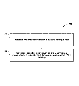
At 102, the process receives roof measurements of a building
having a roof. These measurements may be estimated or actual dimensional
and/or area measurements of the roof such as one or more of: roof edge
lengths, ridge lengths, gable lengths, hip lengths, valley lengths, roof
section
pitch, roof area measurements, planar roof section area measurements, planar
roof section dimension measurements, etc. These roof measurements may be
generated internally by a component of a system that estimates floor area
measurements (i.e., a floor area measurement estimation system) and received
from such an internal component, or may be generated and received from an
CA 3071512 2020-02-05
12
external component or entity separate from the floor area measurement
estimation
system. In some embodiments, the external component is located remotely from
the
floor area measurement estimation system.
For example, in some embodiments, the floor area measurement
estimation system may be a system integrated with a roof estimation system or
other
system that provides roof measurements. In other embodiments, the roof area
measurements may be provided by an external source, system or entity, or may
be
input manually by an operator of the floor area measurement estimation system.
Various received roof measurements may often correspond closely to external
dimensions of the building such as the width and length of the building and/or
lengths
of exterior walls or sections of exterior walls of the building.
At 104, the process generates, based at least in part on the received
roof measurements, an estimated floor area measurement of the building. For
example, the received roof measurements may include roof edge measurements of
the
roof. In such an embodiment, a floor area measurement estimation module of the
floor
area measurement estimation system is configured to generate, based at least
in part
on the received roof measurements, an estimated floor area measurement. In
some
embodiments, the received roof measurements may include roof area
measurements.
In some embodiments, the floor area measurement estimation module of the floor
area
measurement estimation system is configured to generate, based at least in
part on
the received roof area measurements, an estimated floor area measurement. For
example, the roof measurements may be generated by the roof estimation system
described in U.S. Patent No. 8,078,436 issued December 13, 2011, and entitled
AERIAL ROOF ESTIMATION SYSTEMS AND METHODS, U.S. Patent No. 8,209,152
issued June 26, 2012, and entitled CONCURRENT DISPLAY SYSTEMS AND
METHODS FOR AERIAL ROOF ESTIMATION and such a roof estimation system may
be integrated with the floor area measurement estimation system, or various
components of the floor area measurement estimation system described herein.
Also,
features of embodiments described herein may be combined with one or more
other
features of estimating measurements of structures, including those systems and
methods described in U.S. Patent No. 9,599,466, issued March 21, 2017 entitled
13
CA 3071512 2020-02-05
SYSTEMS AND METHODS FOR ESTIMATION OF BUILDING WALL AREA (Attorney
Docket No. 290115.41001).
In many such embodiments, one or more of the roof measurements are
based on aerial photographs of the building via manual or automated analysis
of roof
features, such as by using the roof estimation system or modules described in
one or
more of U.S. Patent Application Serial No. 12/148,439 filed on April 17, 2008
and
entitled AERIAL ROOF ESTIMATION SYSTEM AND METHOD, U.S. Patent No.
8,078,436 issued December 13, 2011, and entitled AERIAL ROOF ESTIMATION
SYSTEMS AND METHODS, U.S. Patent Application Serial No. 12/467,244 filed May
15, 2009 and entitled PITCH DETERMINATION SYSTEMS AND METHODS FOR
AERIAL ROOF ESTIMATION, U.S. Patent Application Serial No. 12/467,250 filed
May
15, 2009 and entitled CONCURRENT DISPLAY SYSTEMS AND METHODS FOR
AERIAL ROOF ESTIMATION, U.S. Patent Application Serial No. 13/019,228 filed
February 1,2011 and entitled GEOMETRIC CORRECTION OF ROUGH WIREFRAME
MODELS DERIVED FROM PHOTOGRAPHS and U.S. Provisional Patent Application
Serial No. 61/594,956 filed February 3, 2012 and entitled SYSTEMS AND METHODS
FOR ESTIMATION OF BUILDING WALL AREA. In some alternative embodiments,
such measurements may be made by an operator or an automated system actually
or
virtually outlining, drawing and/or otherwise detecting the perimeter of the
roof on, or
based on, an aerial image of the roof to indicate an initial estimated floor
shape or foot
print, and providing such data as input used by the system for estimating
floor area
described herein which would otherwise use the roof edge measurements from a
two
or three
14
CA 3071512 2020-02-05
dimensional model of the roof. For example, such outlining or drawing the
perimeter on the roof may be performed within a graphical user interface
displaying the image of the roof such as that shown in Figures 10-15 below.
Thus, utilizing some embodiments described herein, one may estimate floor
area measurements of a building merely using one or more aerial photographs
of the building, with little or no additional information initially needed.
Figure 1B is a flow diagram showing a method 110 that may be
included as part of the generating floor area measurement step of the method
shown in Figure 1A, according to one non-limiting illustrated embodiment.
While each of the steps shown in Figure 1B contributes to the
overall solution, each can be used independently or in various combinations to
yield improvements in estimating floor area measurements as discussed below.
At 112, the process generates roof edge measurements based on
initial roof edge measurements included in the received roof measurements,
assuming each section of the roof has no slope regardless of an actual slope
of
each section of the roof. For example, if the two edges of the gable of a
pitched
roof are 20 feet and the gable has a pitch angle of 90 degrees, then instead
of
two edges of 20 feet, the process generates a single roof edge of sqrt(800)
28.3 feet. The process generates roof edge measurements as if the entire roof
was flat.
At 114, the process uses the roof edge measurements to
calculate an estimated total roof area of the roof assuming each section of
the
roof has no slope. Thus, the process generates roof area measurements as if
the entire roof was flat.
In embodiments in which a roof estimation system is integrated
with the floor area measurement system, the floor area measurement system
first receives a first and a second aerial image of the building, each of the
aerial
images providing a different view of the roof of the building. The system
correlates the first aerial image with the second aerial image to generate a
three-dimensional model of the roof that includes a plurality of planar roof
sections that each have a corresponding slope, area, and edges. In this
CA 3071512 2020-02-05
embodiment, an adjusted roof model is generated by adjusting a slope of the
planar roof sections in the three dimensional model of the roof to
substantially
zero. This may be performed in a variety of manners, including, for example,
removing particular roof features from the model that would not be present in
a
roof with a slope of zero. The planar roof sections in the model become one
large flat roof section. For example, the system will remove ridge lines,
valleys
or other features distinguishing individual planar roof sections. This creates
the
effect of having fused all roof sections together which can be termed as
fusing
them in a virtual software computer sense. This may be also performed instead
of or in addition to by just adjusting a slope parameter or variable of each
roof
section within the roof model to zero. In other embodiments, this step may be
performed with just one initial aerial image of the building showing a
substantially orthogonal view of the building since roof pitch need not be
determined and can be assumed to be zero.
At 116, the process generates the estimated floor area
measurement based on the calculated estimated total roof area of the roof.
This is based on a correlation between the size of the building roof and the
size
of the building. Typically, the floor area of a single full floor of the
building is
roughly the size of the roof of the building if the roof were flat with no
slope (i.e.,
virtually turning the roof into another floor). With additional adjustments to
the
roof area measurements described below (e.g., with respect to Figure 1C) to
account for multiple floors, roof overhang, wall width, internal building
features
such as walls and staircases, and/or obstructed views of the building in the
aerial image(s), etc., an even more accurate floor area estimation is
generated.
In other embodiments, the received roof measurements may
instead or additionally include at least one of: a plurality of dimensional
measurements of a two-dimensional outline of the roof from a top plan view of
the roof and an area of the two-dimensional outline of the roof from the top
plan
view of the roof. In such instances, the dimensions of the two-dimensional
outline of the roof from a top plan view of the roof may be used as the roof
edge
measurements on which to base the estimated floor area. However, these
CA 3071512 2020-02-05
16
dimensional measurements of a two-dimensional outline of the roof need not be
referred to as "roof edge measurements" or "roof measurements" to fall within
the scope of the embodiments described herein.
Figure 1C is a flow diagram showing a method 120 that may be
included as part of the generating total roof area step of the method shown in
Figure 1 B, according to one non-limiting illustrated embodiment. While each
of
the steps shown in Figure 1C contributes to the overall solution, each can be
used independently or in various combinations to yield improvements in
estimating floor area measurements as discussed herein.
At 122, the process subtracts an amount from one or more of the
roof edge measurements corresponding to an estimated roof overhang over
one or more walls of the building to obtain adjusted roof edge measurements.
For example, each roof edge measurement may be reduced by 6 inches to 18
inches corresponding to an estimated roof overhang, which is selectable by a
user of the floor area measurement estimation system. This can be considered
to be eroding the length in a virtual sense by some amount. However, any
variety of other lengths or ranges of lengths may be used including, for
example
a zero length or those of standard or typical roof overhang lengths.
At 124 the process subtracts an amount from one or more of the
adjusted roof edge measurements corresponding to an estimated wall width to
obtain adjusted roof edge measurements. For example, each roof edge
measurement may be reduced by 6 inches to 18 inches corresponding to an
estimated wall width, which is selectable by a user of the floor area
measurement estimation system. However, other lengths or ranges of lengths
may be used (e.g., those of standard or typical wall widths).
At 126 the process receives information regarding floor area
spaces of the building that are not to be included in the estimated floor area
measurement of the building. For example, these areas may be areas of the
building that are not used for living inside the building or areas outside the
building including, but not limited to: garages; attics; unfinished rooms
above
the garage or other locations; covered balconies; patios, decks or porches,
CA 3071512 2020-02-05
17
unfinished basements; crawl spaces; etc. This information may be received
from an external system, source or entity; input by a user (e.g., identified
or
marked by a user on an image or drawing of the building displayed within a
graphical user interface of the system); and/or identified by the system via
analysis of an image of the building.
At 128 the process generates an initial estimated floor area
measurement based on an area corresponding to an extent to which the
spaces that are not to be included in the estimated floor area measurement
extend under the roof and based on the adjusted roof edge measurements. For
example, the roof edge measurements may be used to calculate an estimated
roof area with assumed slope of zero. Then, areas corresponding to an extent
to which such spaces extend under the roof may be subtracted from the
estimated roof area. This also may be performed in response to a user marking
or otherwise identifying such areas on an image or drawing of the building
displayed within a graphical user interface of the system. In some
embodiments, the entire process of generating an initial estimated floor area
is
automated by the system recognizing these particular features in one or more
images of the building through image analysis that utilizes typical
characteristics of such features as viewed from the various angles of those in
the one or more images of the building.
At 130, the process generates the estimated floor area
measurement based on information received regarding a number of stories or
floors of the building. For example, the floor area measurement estimation
system may receive information regarding how many stories the building has
and regarding one or more sections of the roof below which one or more of the
stories extends. The system may then generate the estimated floor area
measurement based on a total area of the one or more sections of the roof
under which each of the stories extends and based on the generated estimated
total roof area of the roof. This total area of the one or more sections of
the roof
under which each of the stories extends may be calculated using the adjusted
roof edge measurements and then adjusted according to various other features
CA 3071512 2020-02-05
18
of the building indentified in the an image of the building or otherwise
received
by the system. These various other features of the building indicate one or
more sections of the roof below which one or more of the stories extends. Such
features identify split level homes, homes with lofts, vaulted ceilings, etc.
The system may determine how many stories the building has
using a second aerial image of the building representing a view from a
different
angle than the substantially orthogonal view of the top of the building such
that
the building height and other features related to how many stories the
building
has may at least be partially seen. This determination may be performed in
response to a user inputting a value representing the number of stories or by
the user marking or otherwise identifying such areas corresponding to the
different stories on an image or drawing of the building displayed within the
graphical user interface of the system. The shape and perimeter of each
building story may be annotated on a drawing or image of the building
displayed in the graphical user interface and manipulated by a user of the
system collectively and/or individually to make the adjustments described
herein. The adjustments will indicate one or more sections of the roof below
which one or more of the stories laterally extends. The estimated total floor
area of the building is then calculated by adding the areas of each identified
floor together to get the total area. The resulting changes in estimated total
floor area are generated by the floor area estimation system and displayed on
the drawing or image of the building displayed in the graphical user
interface.
In some embodiments, the entire process of generating an initial
estimated floor area is automated by the system recognizing these particular
building features (e.g., building stories, floors, etc.) in one or more images
of
the building through image analysis that utilizes typical characteristics of
such
features as viewed from the various angles of those in the one or more images.
Examples of using the estimated floor area of a structure (e.g., a
building) and/or the processes and systems to generate estimated floor area
described herein include using such estimated floor area, processes and/or
systems as part of generating estimates for and/or data for generating
CA 3071512 2020-02-05
19
estimates or assessments regarding insurance coverage for the structure or
real estate including the structure, property risk assessment, and/or
construction and repair of the structure. For example these estimates and/or
assessments include, but not limited to, estimates and/or assessments
regarding: the overall value of a structure; the overall value of real estate
including the structure; cost of replacing or repairing the structure;
insurance
rates or premiums for insuring the structure; determining, predicting and/or
calculating costs of replacing or repairing the structure pursuant to
processing
or paying insurance claims regarding the structure; processing insurance
claims
regarding the structure; managing risk with respect to the structure becoming
or
being damaged and/or risk with respect to insuring and/or paying existing or
potential insurance claims on the structure; etc.
For example, Figure 1D is a flow diagram showing method 135 of
generating a risk management report, which in some instances may use the
floor area measurements or methods for generating the floor area
measurements described herein, according to one non-limiting illustrated
embodiment.
While each of the steps shown in figure 1D contributes to the
overall solution, each can be used independently or in various combinations to
also yield improvements in producing a risk management report as discussed
below. Below is an overview of each step in the process, which will be
followed
by a more detailed discussion of each step.
At 135a, the process receives risk management criteria from an
entity, wherein the risk management criteria are used to create a risk
management profile of a particular property. For example, an insurance
company may have risk management criteria that it uses to evaluate a property
to create a risk management profile of the property. This permits an insurance
company to manage the risk with respect to the structure on the property or
other features of the property becoming or being damaged and/or risk with
respect to insuring and/or paying existing or potential insurance claims on
the
property. This profile can be used, for example, to determine which insurance
CA 3071512 2020-02-05
products and at what premiums it will offer the owner. The risk management
criteria may include but is not limited to conditions of aspects of buildings
on the
property, density and size of vegetation on the property, property terrain
features such as steepness of slope or water features, and nearness to
commercial areas or fire stations.
At 135c, the process receives one or more aerial views of the
property and surrounding area. In some embodiments, these aerial views may
include top-down, substantially orthogonal views, or oblique views showing the
property and buildings at an angle. In some embodiments these aerial views
may be used to evaluate the features and conditions of the property.
At 135e, the process receives additional data from one or more
sources. These sources may include, but are not limited to, insurance
companies, government entities, contractors, and the like. The sources may
also include systems that have generated roof estimations, wall estimations,
or
floor estimations.
At 135g, the process evaluates the received aerial views and
received additional data using the risk management criteria to determine the
risk management profile of the property. In some embodiments, this evaluation
involves a human operator viewing the aerial images and the additional data to
answer questions about the property that correspond to risk management
criteria used to assess the risk management profile of the property. In other
embodiments, this evaluation involves graphical image processing, data
management, and/or statistical methods to answer the questions.
At 135i, the process generates a risk management profile report
for the property based on the evaluation completed in the previous step.
At 135k, the process stores the risk management profile
information. In some embodiments, this information is stored along with
profiles
of other properties to be used for various purposes such as property risk
history.
At 135m, the process distributes the risk management profile
report. In some embodiments, the report is sent to the insurance company, the
CA 3071512 2020-02-05
21
insurance agent, the property owner, or other entity that uses the risk
profile to
make decisions concerning the property.
At 1350, the process provides additions, updates, and/or
corrections to the data received. In some embodiments, the evaluation process
which uses property data from many sources may uncover errors or other
problems which the source of the data may wish to know about and correct. For
example, a building's total living area as determined by an operator using
current aerial views may not match the total living area documented in county
tax records. The county may wish to update their records to determine a fair
tax
valuation for the property. In some embodiments, discrepancies discovered in
data that exceed a tolerance threshold may generate an automatic notification
to the source of the data. In another embodiment, the data may be directly
updated by the process.
At 135q, the process receives underwriting criteria from insurance
companies that describes the insurance products and premium amounts the
company offers based on the features and risk management profile of a
property. In one embodiment, the criteria determines the features or
combination of features on the property that will cause it to the insurable,
and
provides the formulas that use the conditions of features on the property to
determine insurance premium cost.
At 135r, the process determines the insurance products to offer
and the pricing of the products for the property. In one embodiment, certain
features and conditions of the property will be associated with certain
insurance
products. For example, if a residential property also has one or more
commercial buildings on it, than a commercial insurance product may be
appropriate. In another example, if the residential property has an RV parked
in
the yard, offering an auto insurance product that covers the RV may be
appropriate. In another embodiment, criteria involving conditions of features
on
the property may determine the premium amounts offered for a particular
policy. For example, if the condition of the roof of a residential building
appears
CA 3071512 2020-02-05
22
excessively worn or damaged, the premiums for ensuring that building will be
higher than if the roof was not damaged.
Figure lE is a flow diagram showing an example method 140 of
receiving risk management criteria used to create a risk management profile of
a property step of the method shown in Figure 1D, according to one non-
limiting
illustrated embodiment. While each of the steps shown in Figure lE contributes
to the overall solution, each can be used independently or in various
combinations to yield improvements in receiving risk management criteria from
an entity as discussed below.
At 140a, the process receives risk management criteria from an
entity used to create a risk management profile of a property. In one
embodiment, the criteria are used to evaluate features of the property to
create
a risk management profile of the property. Features of the property may
include
but are not limited to buildings, vegetation, terrain, distance to water,
distance
_
to commercial areas, and distance to a fire station. Features of a building
may
include but are not limited to year built, number of stories, style of roof,
floor
area, and number of windows. In addition, the criteria may also describe
various conditions of the features of a property. In one or more embodiments,
the criteria may be received as a data file that may be imported into an
evaluation system.
At 140c, the process stores the risk management criteria received
from each company. In one embodiment, the criteria from each company are
stored in a database and used during the evaluation process, described below,
when the property risk assessment profile is being created.
At 140e, the process determines the criteria elements that are
common among companies. In one embodiment, elements are reviewed by an
operator to determine the common elements. In another embodiment elements
are compared electronically.
At 140g, the process uses the common criteria elements to allow
risk management profile evaluation comparison among companies. In one
CA 3071512 2020-02-05
23
embodiment, this allows the evaluation process, described below, to
efficiently
produce risk management profile reports for a number of insurance companies.
Figure 1F is a flow diagram showing an example method 150 of
receiving additional data from one or more sources to used to determine a risk
management profile step of the method shown in figure 1D, according to one
non-limiting illustrated embodiment. While each of the steps shown in Figure
1F
contributes to the overall solution, each can be used independently or in
various
combinations to yield improvements in receiving additional data from one or
more sources as discussed below.
At 150a, the process receives one or more aerial views of the
property. In one or more embodiments, these aerial views may include a top-
down, or substantially orthogonal view of the property, and/or oblique views
of
the property taken at angles from different directions. For example, an
oblique
aerial view of the property may be taken at a 45 angle from the north, and
another taken at a 50 angle from the west. In one embodiment, these aerial
views are provided in a digital format.
At 150c, the process receives floorplan estimates and total living
area estimates for buildings on the property. In one embodiment, these
estimates are received from the roof estimation system or a floor area
measurement system described herein. In another embodiment the estimates
may come from county records.
At 150e, the process receives data generated from modeling or
estimation software for buildings. In one or more embodiments, this data may
be generated by a roof estimation systems, wall estimation systems, 3D
modeling systems, CAD systems, or the like.
At 150g, the process receives data on file for similar houses in the
community. In one or more embodiments, this data may include the date the
neighborhood was developed, the average age of houses, typical
improvements done to property, and the like.
At 150i, the process receives government records on the property.
In one or more embodiments, these records may include but are not limited to
CA 3071512 2020-02-05
24
information received from county or city building departments, which include
building plans, building permit information, as-built information and the
like.
The records may also include government tax records that include estimated
total living area of buildings on the property.
At 150K, the process receives data from contractor or
construction firms. In one or more embodiments, this may include but is not
limited to blueprints, as-built information, landscape elevations, and repair
information.
At 150m, the process receives data from scans of the property. In
one or more embodiments, these scans may include but are not limited to
infrared scans, thermal imaging scans, and the like.
At 1500, the process receives property data collected on-site. In
one or more embodiments, this data includes but is not limited to visual
information on property features, for example external and internal property
features of buildings. Examples of external features are the condition of
walls,
roofs, chimneys, skylights, porches, patio, decks, garages, and other exterior
features. Example of internal features are the conditions of walls, ceilings,
floors, carpeting, windows, fixtures, skylights, and other interior features.
Conditions of other property features may include but are not
limited to terrain, vegetation, water hazards, trampolines, hot tubs, swimming
pools, outbuildings, automobiles, or other outside features relevant to
determine
a risk management profile.
In some embodiments, this visual information may be captured
using an image or video recording device by the property owner or one or more
other individuals evaluating the property. In some embodiments, the data
collected may include but is not limited to interviews with property owners,
tenants, or one or more neighbors.
In other embodiments, data collected may include data from
chemical samples, odor detectors, radiation detectors, radon detectors,
moisture detectors, RFI detectors and the like. =
CA 3071512 2020-02-05
In one or more embodiments, additional data required during the
evaluation process, described below, may be requested from one or more
individuals who are evaluating the property.
At 150q, the process receives data collected from insurance
companies. In one or more embodiments, this data may include but is not
limited to existing photographs of the property, descriptions and measurements
of features on the property, insurance claims history of the property and the
like. In addition this data may include insurance data available for buildings
or
property near the property being evaluated.
Figure 1G is a flow diagram showing a method 155 that may be
included as a part of the evaluate the aerial views and received data in light
of
risk management criteria step of the method shown in figure 1D, according to
one non-limiting illustrated embodiment. While each of the steps shown in
Figure 1G contributes to the overall solution, each can be used independently
or in various combinations to yield improvements in evaluating the aerial
views
and received data as discussed below.
At 155a, the process generates questions for assessing the
individual elements of the risk management criteria for the property. In one
embodiment, a question is created for each criteria element. For example, if
an
element is the age of a building, a generated question may be "what year was
the building built?"
At 155c, the process uses the aerial views and received data to
provide answers to the generated questions. In one or more embodiments, the
answers to the questions may be but are not limited to being provided by an
operator at a workstation viewing the images and the data, an automated
system analyzing the aerial views and received data, and one or more
individuals viewing the aerial views and receive data according to a crowd
sourcing model.
At 155e, the process receives questions to answer. In one non-
limiting embodiment, an individual at a workstation is viewing the aerial
images
CA 3071512 2020-02-05
26
and the received data. However, in some embodiments, this process may be
automated.
At 155g, the process evaluates data and aerial images to answer
the received questions. In this embodiment, an operator at a workstation is
viewing the aerial images, the received data and the received questions, and
is
answering the questions based on the operator's evaluation of the images and
data.
At 155i, the process provides a confidence rating for answers to
the questions. In one embodiment, the operator enters a confidence rating for
each individual question answered. In another embodiment, the operator
enters an overall confidence rating once all questions are answered.
At 155k, the process receives questions to answer. In one non-
limiting embodiment, the aerial images and received data are analyzed by an
automated system to determine the answers.
At 155m, the process uses graphical processing to analyze
received aerial views to identify features of the property. In one non-
limiting
embodiment, a feature of the property may be a building, terrain, water
feature,
vegetation, or other characteristic of the property relevant to a risk
management
assessment.
At 155n, the process uses visual recognition, graphical analysis,
and the like to identify features and conditions of the property to determine
answers to the questions. For example, to identify roof wear or prior patch
made to the roof by analyzing the pattern or color differences identified on
the
roof or to identify the condition of the skylight or window by using optical
density
analysis. In another example, to use visual analysis to determine the distance
to the nearest water feature or to determine the style of a building, or to
identify
if a trampoline or swimming pool is located on the property.
At 155o, the process uses graphical processing to compare
similar aerial views of the property taken at different times to determine
answers to the questions. Examples include but are not limited to identifying
the
rate of deterioration of an outbuilding roof, the rate of growth of
vegetation,
CA 3071512 2020-02-05
27
whether any structures have been newly built or modified, whether damage to a
structure has been sustained but unrepaired over time such as hailstorm
damage, and the like.
At 155p, the process uses data processing to analyze data about
neighboring properties to estimate answers to the questions. Examples include
but are not limited to the age of surrounding buildings, the age of the
neighborhood, the condition of surrounding property, and the like.
At 155q, the process uses statistical techniques to determine the
confidence rating for answers to the questions. These techniques include but
are not limited to analyzing the resolution of aerial views, any obstruction
by
trees of views to the buildings, age of data received indicating it may be out
of
date, and the like.
At 155r, the process receives questions to answer. In one non-
limiting embodiment, the evaluation is performed using a crowd sourcing model,
in which, for example a number of individuals view the aerial views and
additional data, and answer the questions.
At 155s, the process identifies the evaluators that will receive the
questions, the additional data, and aerial images. In one or more embodiments
the evaluators may be but are not limited to volunteers, paid contractors, the
property owner, to the property tenant, to neighbors of the property, and the
like.
At 155t, the process sends the questions, data, and aerial images
to the evaluators. In one or more non-limiting embodiments, this may be done
electronically via email, a Smartphone application, on paper, or the like.
At 155u, the process evaluates the data and aerial images to
answer the questions. In one or more non-limiting embodiments, this may be
done by an individual operator at a workstation, by an automated process, or
by
a combination of both.
At 155v, the process provides a confidence rating for answers to
the questions. In one or more embodiments, the operator may enter either a
confidence rating for each individual question answered, or an overall
CA 3071512 2020-02-05
28
confidence rating once all questions are answered. Or, if using an automated
process, statistical techniques may be used to determine the confidence
rating.
At 155W, the process receives the answers from the evaluators.
In one or more non-limiting embodiments, this may be done electronically, via
email, a Smartphone application, on paper, or the like.
At 155X, the process assesses the accuracy of each evaluator for
use in selecting future evaluators. In one or more embodiments, the
assessment may take the form of, but not limited to, several techniques. In
one
non-limiting example, statistical techniques may be used to generate the most
likely correct answer for each question answered by the evaluator and compare
that answer to the evaluator's answer. In another non-limiting example,
individuals may review the evaluations done by each evaluator and vote on the
accuracy of the each evaluation.
Figure 1H is a flow diagram showing a method 160 that may be
included as part of providing additions, updates, and/or corrections to the
data
received step of the method shown in Figure 1D, according to one non-limiting
illustrated embodiment. While each of the steps shown in figure 1H contributes
to the overall solution, each can be used independently or in various
combinations to yield improvements in providing additions, updates, and/or
corrections to the data received as discussed below.
At 160c, the process identifies data that has been found during
the evaluation process to be incorrect. In one or more embodiments, examples
of this data include but are not limited to images that are out of date, area
estimates of buildings that are incorrect, number of listed outbuildings that
is not
correct, and the like. In one or more embodiments, the term "correct" may
include a deviation within a certain tolerance level.
At 160e, the process reports to the source of the data that the
data is not correct. In one or more embodiments, this may include but is not
limited to notifying the source of the data (e.g. an insurance company) that
the
data is not correct, sending the source the correct data, updating the source
with the correct data, and the like.
CA 3071512 2020-02-05
29
Figure 11 is a flow diagram showing a method 165 that may be
included as part of the receiving underwriting criteria for insurance product
offers and pricing for the property step of the method shown in figure 1D,
according to one non-limiting illustrated embodiment. While each of the steps
shown in Figure 11 contributes to the overall solution, each can be used
independently or in various combinations to yield improvements in estimating
floor area measurements as discussed below.
At 165a, the process receives underwriting criteria to determine
the insurance products and premiums available based on a property's risk
assessment profile. Examples of this underwriting criteria include but are not
limited to a list of the features of a property that corresponds to a
particular
insurance products offered by the company and the various conditions of the
features of the property that affect premium cost of each insurance product.
At 165c, the process receives the property risk management
profile. In one non-limiting embodiment, the property risk management profile
is
retrieved from a database containing property risk management profiles.
At 165e, the process determines the insurance products and
pricing for the property. In one non-limiting embodiment, the process compares
the features and conditions of the property found in the property risk
management profile to the received underwriting criteria to determine what
insurance products are available for the property and the premium cost of each
insurance product.
At 165g, the process determines if the confidence rating for the
property risk management profile is high enough to not send a person to the
property for an on-site inspection. In one non-limiting embodiment, the
confidence rating that is part of the properties risk management profile is
compared with other factors including but not limited to the features of the
property, the condition of the features of the property, the dollar cost of
the
insurance products being quoted, cost to send someone for an on-site
inspection, and the like. A company may, based on the comparison, either
CA 3071512 2020-02-05
choose to not send a person on-site and instead "desk underwrite" the
insurance products.
Figure 2 is an example screenshot of a user interface of a system
for generating floor area measurements with roof sections annotated on an
aerial image of the roof, according to one non-limiting illustrated
embodiment.
For example, the screenshots of Figures 2-8 are screenshots of the graphical
user interface of the floor area measurement system which performs the
processes described in Figures 1A-1C above.
Shown is a graphical user interface including two panels, one with
an image of a building showing a top substantially orthogonal view 202 of the
building and the other with an image of the building showing a top oblique
view
204 of the same building. Also shown is an annotation 212, which is a line
drawing of a three dimensional model of the roof. The annotation 212 is an
adjustable graphical user interface element overlaid on the roof of the
building
in each image corresponding to the angle of view 202 and view 204 of the roof
in each image. The annotation 212 also shows various planar sections of the
roof as delineated by the roof features and roof lines, such as the ridge
line,
valley lines and roof eaves, etc. This annotation 212 is an interactive
graphical
user interface feature and may be manipulated by a user of the system to make
various adjustments to roof features and characteristics for the purpose of
generating roof measurements, such as those used in the processes shown in
Figures 1A-1C and other embodiment described herein. These may be
performed by user interaction with the annotation itself and/or various
selectable controls 206.
Also shown are image selection bars 208 and 210 which display
thumbnail or reduced-size images of various other images showing the building
from other perspectives and view angles. Selection bar 208 is located above
view 202. When a particular thumbnail image in selection bar 208 is selected,
the image showing the current view 202 is replaced with that of the selected
image. Similarly, selection bar 210 is located above view 204. When a
CA 3071512 2020-02-05
31
particular thumbnail image in selection bar 210 is selected, the image showing
the current view 204 is replaced with that of the selected image.
Figure 3 is an example screenshot 300 of a user interface of the
system of Figure 2 for generating floor area measurements with area
measurements 302, 304 and 306 of roof sections annotated on an aerial image
of the roof, according to one non-limiting illustrated embodiment. For
example,
when the user selects the "next button" 214 shown in Figure 2, the floor area
measurement estimation system calculates the areas 302, 304 and 306 of each
roof section according to the roof annotation 212, as adjusted by the user,
and
displays these area values 302, 304 and 306 on the corresponding sections of
the roof in the displayed image. Also shown is a "Fuse" button 308, the
selection of which causes results to be displayed as shown in Figure 4.
Figure 4 is an example screenshot 400 of a user interface of the
system of Figure 2 for generating floor area measurements showing the roof
annotated with an estimated total roof area 402 on which to base an estimated
floor area measurement, such as that estimated in the method of Figures 1A-
1C, according to one non-limiting illustrated embodiment. For example, when
the user selects the "Fuse" button 308 shown in Figure 3, the floor area
measurement estimation system may perform the acts 112 and 114 of the
process shown in Figure 1B to calculate an estimated total roof area of the
roof
by setting each section of the roof to a zero slope.
In this embodiment, the floor area measurement estimation
system generates an adjusted roof model by adjusting the slope to
substantially
zero of the planar roof sections having areas 302, 304 and 306 shown in Figure
3 in the three dimensional model of the roof represented by annotation 212.
This may be performed in a variety of manners, including, for example, by
removing particular roof features from the model represented by annotation 212
in Figure 3 that would not be present in a flat roof with no slope. This could
be
considered "fusing" individual planar roof sections in the model into one flat
roof
section, such as by removing ridge lines or other features distinguishing
individual planar roof sections instead of, or in addition to, adjusting a
slope
CA 3071512 2020-02-05
32
parameter or variable within the model to zero. This process results in the
adjusted annotation 212 displayed by the system as shown in Figure 4 without
lines indicating roof features such as ridge lines associated the pitched
roof.
Thus, the system generates and provides roof edge measurements using the
roof model as if the entire roof was flat with no slope, as shown by the
annotation 212 representing the roof model in Figure 4.
Although the screenshot of the graphical user interface 300 shows
both the orthogonal view 202 and oblique view 204, in other embodiments, this
action may be performed with just one initial aerial image of the building
using
and/or showing only the substantially orthogonal view 202 of the building
since
roof pitch need not be determined and can be assumed to be zero.
Also shown is an "Erode" button 402, the selection of which
causes results to be displayed as shown in Figure 5, as will be explained in
conjunction with Figure 5 below.
Figure 5 is an example screenshot 500 of a user interface of the
system of Figure 2 for generating floor area measurements showing the
building annotated with an adjusted estimated floor area measurement, such as
that estimated in the method of Figures 1A-1C, according to one non-limiting
illustrated embodiment. For example, when the user selects the "Erode" button
402 shown in Figure 4, the floor area measurement estimation system will
perform the acts 122 and 124 of the process shown in Figure 1C to calculate an
adjusted estimated total roof area of the roof by subtracting an amount from
each section of the roof to account for an eave overhang distance.
In this embodiment, the floor area measurement estimation
system subtracts an amount from one or more of the roof edge measurements
in the roof model represented by annotation 212 corresponding to an estimated
roof overhang over one or more walls of the building to obtain adjusted roof
edge measurements. For example, each roof edge measurement may be
reduced (i.e., "eroded") by 6 inches to 18 inches corresponding to an
estimated
roof overhang, which is selectable by a user of the floor area measurement
estimation system. However, other lengths or ranges of lengths may be used.
CA 3071512 2020-02-05
33
The floor area measurement estimation system may also subtract
an amount from one or more of the adjusted roof edge measurements in the
roof model represented by annotation 212 corresponding to an estimated wall
width to obtain adjusted roof edge measurements. For example, each roof
edge measurement may be reduced (i.e., "eroded") by 6 inches to 18 inches
corresponding to an estimated wall width, which is selectable by a user of the
floor area measurement estimation system. However, other lengths or ranges
of lengths may be used.
The amount of length subtracted from a line to obtain a more
accurate measure of the internal footprint of the home will vary depending on
the factor being subtracted for. If the factor being subtracted for is an
eave, the
value may be 2 feet, 3 feet, or another selected amount which may be a default
value, such as 2 feet, or a value selected by an operator from seeing a second
image of the home, which provides an oblique view of the overhang difference,
which in some homes might be 4 feet. On the other hand, if the subtraction is
for a wall thickness, the amount will usually be 6 inches or at most 10
inches.
For a porch or deck, the amount might be 10 feet, 12 feet or some other value,
based on an estimate of the true distance from an operator viewing one or more
oblique images.
In some embodiments, each time a user selects the "erode"
button 402, an additional adjustment shortening the lengths of the roof edges
will be performed by the system. Note that the annotation 212 in Figure 5 is
now adjusted corresponding to the adjusted roof edge lengths such that the
actual edges of the roof in the image shown in both the orthogonal view 202
and oblique view 204 extend beyond the borders of the annotation 212. The
corresponding roof area measurement 502 is also therefore adjusted
accordingly by the floor area measurement estimation system (e.g., from 2144
square feet down to 1855 square feet as shown in Figures 4 and 5,
respectively).
Figure 6 is an example screenshot 600 of a user interface of the
system of Figure 2 for generating floor area measurements showing the
CA 3071512 2020-02-05
34
building annotated with adjusted estimated first floor and second floor area
measurements, such as that estimated in the method of Figures 1A-1C,
according to one non-limiting illustrated embodiment. For example, the user
may manipulate or otherwise adjust the annotation 212, or add additional
annotations to represent multiple floors of the building as identified in the
oblique view 204 of the building. Based on these adjustments, the floor area
measurement estimation system may perform act 130 of the process shown in
Figure 1C to generate the estimated floor area measurement based on
information received regarding a number of stories of the building. For
example, the floor area measurement estimation system may receive
information regarding how many stories the building has and regarding one or
more sections of the roof below which one or more of the stories laterally
extends. The system may then generate the estimated floor area measurement
based on a total area of the one or more sections of the roof under which each
of the stories extends and based on the generated estimated total roof area of
the roof.
In the example embodiment shown in Figure 6, shown is a first
floor annotation 602 and a second floor annotation 604 that combined form
annotation 212. The relationship between the first floor, second floor and
roof
can be seen form a different perspective in the oblique view 204 as the second
floor annotation 604 shows that the second floor laterally extends
substantially
the entire length of the roof. However, the first floor annotation 602 shows
that
the first floor laterally extends about half way the length of the roof and
the
second floor due to the garage. The first floor annotation 602 and a second
floor annotation 604 may be directly or indirectly manipulated and adjusted
resulting in different area measurements of the floor represented by these
annotations.
Also, first floor annotation 602 and second floor annotation 604
may be directly or indirectly manipulated and adjusted to account for spaces
that are not to be included in the estimated floor area measurement. For
example, these areas may be areas of the building that are not used for living
CA 3071512 2020-02-05
inside the building or areas outside the building, including but not limited
to:
garages; attics; unfinished rooms above the garage or other unfinished spaces;
covered balconies; patios, decks or porches, basements; crawl spaces; etc.
This also may be performed in response to a user marking or otherwise
identifying such areas on the first floor annotation 602 and second floor
annotation 604, or otherwise adjusting the dimensions of the sides of the
first
floor annotation 602 and second floor annotation 604 to "notch" out or "cut"
out
such areas. In some embodiments, selectable graphical user interface items
are provided representing such spaces. When selected an placed on the first
floor annotation 602 and second floor annotation 604, a an area corresponding
to a standard size and/or shape of such a space will be removed from the first
floor annotation 602 and second floor annotation 604, and the floor area
measurements will be adjusted accordingly.
For example, a selectable graphical user interface item
representing a standard two-car garage may be selected by a user and placed
in a position on the first floor annotation 604 overlaid on the image of the
building corresponding to where a garage of the building is located. The floor
area measurement estimation system will then subtract an area corresponding
to the area of the standard two-car garage from the area of the first floor
according to the position of the graphical user interface item representing
the
standard two-car garage on the first floor annotation 604.
Figure 7 is an example screenshot 700 of a user interface of the
system of Figure 2 for generating floor area measurements showing a line
drawing of a top plan view of each the first and second floor of the building
annotated with corresponding floor area measurements of the building shown in
Figure 6, such as that estimated in the method of Figures 1A-1C, according to
one non-limiting illustrated embodiment. The line drawing represents the first
floor annotation 602 and the second floor annotation 604 shown in Figure 6.
Note that the corresponding estimated floor areas are displayed on each
annotation. These are adjusted by the floor area measurement estimation
CA 3071512 2020-02-05
36
system upon manipulation of the corresponding first floor annotation 602 or
second floor annotation 604 by the user.
Figure 8 is an example screenshot 800 of a user interface of the
system of Figure 2 for generating floor area measurements showing a line
drawing of a top perspective view of the first and second floor of the
building
shown in Figure 6 annotated with corresponding floor area measurements,
such as that estimated in the method of Figures 1A-1C, according to one non-
limiting illustrated embodiment. Shown in this manner in the graphical user
interface of the floor area measurement estimation system, a user may
manipulate the corresponding first floor annotation 602 and/or second floor
annotation 604 and see the visual effects of the changes according to the
positional relationships between the first and second floors corresponding to
the
oblique view 204 shown in Figure 6.
Provided the example in Figure 8, the total estimated floor area of
the building is 2866 square feet (1076 square feet as noted on the first floor
annotation 602 plus 1790 square feet as noted on the second floor annotation
604). Various reports may be generated showing the estimated areas of the
various floor and/or the estimated total floor area of the building. For
example,
a report may be generated by the building floor area measurement estimation
system or by using the data provided by the building floor area measurement
estimation system that includes diagrams similar to the screenshots 700 and
800 shown in Figure 7 and 8, respectively either alone or overlaid on the
corresponding images of the building shown in Figure 6.
Figure 9 is a schematic diagram of a computing environment in
which systems and methods for estimation of building floor area may be
implemented or of which they may be a part. For example, processes 100, 110
and 120 described above in conjunction with Figures 1A-1C may be performed
or implemented by, for example, one or more software modules or components
or any combination of suitable hardware, firmware or software components or
devices including those that are a part of, stored in, or configure the
computing
environment of Figure 9. Also, the graphical user interface functions and
CA 3071512 2020-02-05
37
features may be performed or implemented by, for example, one or more
software modules or components or any combination of suitable hardware,
firmware or software components or devices including those that are a part of,
stored in, or configure the computing environment of Figure 9.
The computing environment 900 will at times be referred to in the
singular herein, but this is not intended to limit the embodiments to a single
device since in typical embodiments there may be more than one computer
system or device involved. Unless described otherwise, the construction and
operation of the various blocks shown in Figure 9 are of conventional design.
As a result, such blocks need not be described in further detail herein, as
they
will be understood by those skilled in the relevant art.
The computing environment 900 may include one or more
processing units 912a, 912b (collectively 912), a system memory 914 and a
system bus 916 that couples various system components including the system
memory 914 to the processing units 912. The processing units 912 may be any
logic processing unit, such as one or more central processing units (CPUs)
912a, digital signal processors (DSPs) 912b, digital video or audio processing
units such as coder-decoders (codecs) or compression-decompression units,
application-specific integrated circuits (ASICs), field programmable gate
arrays
(FPGAs), etc. The system bus 916 can employ any known bus structures or
architectures, including a memory bus with memory controller, a peripheral
bus,
and a local bus. The system memory 914 includes read-only memory ("ROM")
918 and random access memory ("RAM") 920. A basic input/output system
("BIOS") 922, which can form part of the ROM 918, contains basic routines that
help transfer information between elements within the computing environment
900, such as during start-up.
The computing environment 900 may include a hard disk drive
924 for reading from and writing to a hard disk 926 (including a solid state
memory device), an optical disk drive 928 for reading from and writing to
removable optical disks 932, and/or a magnetic disk drive 930 for reading from
and writing to magnetic disks 934. The optical disk 932 can be a CD-ROM,
CA 3071512 2020-02-05
38
while the magnetic disk 934 can be a magnetic floppy disk or diskette. The
hard disk drive 924, optical disk drive 928 and magnetic disk drive 930 may
communicate with the processing unit 912 via the system bus 916. The hard
disk drive 924, optical disk drive 928 and magnetic disk drive 930 may include
interfaces or controllers (not shown) coupled between such drives and the
system bus 916, as is known by those skilled in the relevant art. The drives
924, 928 and 930, and their associated computer-readable storage media 926,
932, 934, may provide nonvolatile and non-transitory storage of computer
readable instructions, data structures, program modules and other data for the
computing environment 900. Although the depicted computing environment
900 is illustrated employing a hard disk 924, optical disk 928 and magnetic
disk
930, those skilled in the relevant art will appreciate that other types of
computer-readable storage media that can store data accessible by a computer
may be employed, such as magnetic cassettes, flash memory, solid state
drives, digital video disks ("DVD"), Bernoulli cartridges, RAMs, ROMs, smart
cards, etc. For example, computer-readable storage media may include, but is
not limited to, random access memory (RAM), read-only memory (ROM),
electrically erasable programmable read-only memory (EEPROM), flash
memory, compact disc ROM (CD-ROM), digital versatile disks (DVD) or other
optical disk storage, magnetic cassettes, magnetic tape, magnetic disk storage
or other magnetic storage devices, solid state memory or any other medium
which can be used to store the desired information and which may be accessed
by processing unit 912a.
Program modules can be stored in the system memory 914, such
as an operating system 936, one or more application programs 938, other
programs or modules 940 and program data 942. Application programs 938
may include instructions that cause the processor(s) 912 to perform generating
digital roof models, generating roof and floor area measurements, and store
and display input images or images generated by generating digital roof models
and generating roof and floor area measurements, including the processes
described herein. Other program modules 940 may include instructions for
CA 3071512 2020-02-05
39
handling security such as password or other access protection and
communications
encryption. The system memory 914 may also include communications programs,
for
example, a Web client or browser 944 for permitting the computing environment
900 to
access and exchange data including digital images, roof measurements and other
building data with sources such as Web sites of the Internet, corporate
intranets,
extranets, or other networks and devices, as well as other server applications
on
server computing systems. The browser 944 in the depicted embodiment is markup
language based, such as Hypertext Markup Language (HTML), Extensible Markup
Language (XML) or Wireless Markup Language (WML), and operates with markup
languages that use syntactically delimited characters added to the data of a
document
to represent the structure of the document. A number of Web clients or
browsers are
commercially available such as those from MozillaTM, GoogleTm, and MicrosoftTM
of
Redmond, Washington.
While shown in Figure 9 as being stored in the system memory 914, the
operating system 936, application programs 938, other programs/modules 940,
program data 942 and browser 944 can be stored on the hard disk 926 of the
hard disk
drive 924, the optical disk 932 of the optical disk drive 928 and/or the
magnetic disk
934 of the magnetic disk drive 930.
An operator can enter commands and information into the computing
environment 900 through input devices such as a touch screen or keyboard 946
and/or
a pointing device such as a mouse 948, and/or via a graphical user interface
in order to
receive, process, store and send data on which floor area measurement
estimation has
been or will be performed as described herein. Other input devices can include
a
microphone, joystick, game pad, tablet, scanner, etc. These and other input
devices
are connected to one or more of the processing units 912 through an interface
950
such as a serial port interface that couples to the system bus 916, although
other
interfaces such as a parallel port, a game port or a wireless interface or a
universal
serial bus ("USB") can be used. A monitor 952 or other display device is
coupled to
the system bus 916 via a video interface 954, such as a video
CA 3071512 2020-02-05
adapter which may be configured to display images used by or generated by
floor area measurement estimation as described herein. The computing
environment 900 can include other output devices, such as speakers, printers,
etc.
The computing environment 900 can operate in a networked
environment using logical connections to one or more remote computers and/or
devices. For example, the computing environment 900 can operate in a
networked environment using logical connections to one or more other
computing systems, mobile devices and other service providers or information
servers that provide the digital images in various format or by other
electronic
delivery methods. Communications may be via a wired and/or wireless network
architecture, for instance wired and wireless enterprise-wide computer
networks, intranets, extranets, telecommunications networks, cellular
networks,
paging networks, and other mobile networks.
Figure 10 is an example screenshot 702 of a user interface of a
floor plan editor tool for generating floor area measurements, which may be
used independently of, as part of, or integrated with the systems and methods
for generating a risk management report described herein. In one embodiment,
the tool consists of a floor plan editor 300, a facet label editor 302, and
control
buttons 304. The floor plan editor 300 consists of an approximately orthogonal
view of the property 306 over which the software operator can draw shapes,
such as rectangles, to outline the dimensions and area of different
approximate
floor areas of different sections of the house or building 308. The facet
label
editor 302 is a window that displays multiple aerial views of the property. In
this
example, the operator is looking at a West view which is indicated in area
310.
Below this area there are a series of thumbnail images 314, with the current
image being viewed highlighted 312. The highlighted image 312 indicates the
expanded view of the image shown below 320. The operator, when drawing
the floor areas 308, uses the multiple views of the property that are
referenced
by the thumbnail images 314 to determine the various features and facet types
of the building for which the operator wants to estimate a floor area. An
CA 3071512 2020-02-05
41
example of these facet types and features are listed in the facet label editor
as
facet type buttons 316. These facet types include, but are not limited to,
footprint 316a, outbuilding 316b, garage 316c, first floor 316d, second floor
316e, third floor 316f, deck 316g, patio 316h, and porch 316i. The operator
may select one of these buttons to associate one floor plan shape drawn on the
building 308.
Control buttons 304 allow the operator to adjust floor plan shapes
and choose different views of the property to show on the facet label editor
302.
The operator can select the image 320 to diplay by using either the left arrow
318a or the right arrow 318b to move the selected thumbnail image, in this
case
image 312, to the desired image to be shown. Selecting different aerial images
of the property taken at different angles allows the operator to better
understand the structure of the building to determine the number of floors,
the
levels, garages, decks, patios, porches, or other features of the building.
The
erode button 330 allows a floor plan shape that is selected from among the
number of floor plan shapes 308 to have its edges slightly reduced, for
example, by 16 inches to 18 inches. Conversely, the dilate button 332 will
enlarge the size of the selected shape by a small amount. The erode and dilate
features are used as fine-tune adjustments by the operator to adjust the
rectangle shape to the approximate floor plan of the building section that is
being estimated. The checklist button 322 will take the user to the gathering
property assessment screens described starting in Figure 16. When the
operator has finished drawing all the shapes and is satisfied with the
drawings
of the floor plan, the operator selects the finish button 326. To reject the
changes and start over, the operator selects the reject button 324.
Figure 11 is an example screenshot 704 of the user interface of
the system described in Figure 10. Here, the operator has zoomed in, using
the floor plan editor, on the image showing the top of the building being
measured 306. In one embodiment, the operator uses a mouse to move cursor
336 to different locations over the house to draw rectangles that represents
floor areas the operator wishes to measure. For example, if the operator
CA 3071512 2020-02-05
42
wished to estimate the measurement of the deck 338, the operator would first
select the deck facet types button 316g, then on the floor plan editor image
306
select the four corners that appear to the operator to be the corners of deck
338. Once the operator has completed this for all of the floor plan areas
desired to be captured, the operator can go to the facet label editor
thumbnail
images 314 and select the top view, in this example by selecting thumbnail
340,
which shows the top view of the building in the facet label editor overlaid
with
the different facet types as identified by the operator. In this example, the
facet
types are differentiated by different names, such as garage, footprint, first
floor,
second floor, deck, etc. and are also distinguished by color: magenta, beige,
blue, dark blue, gray, etc. In addition, the dimensions and the areas
associated
with each facet type footprint also appear in the same color in the floor plan
editor overlaid on the top-down image 306.
Figure 12 is an example screenshot 706 of the user interface of
the system from Figure 10. In this example, the user has selected thumbnail
342, which is an oblique aerial view of the property facing east. The operator
may use this view to verify the operator's choices of the different facet
types for
the floor areas.
Figure 13 is an example screenshot 708 of the user interface of
the system of Figure 10. Here, the operator has selected thumbnail 344, which
is a oblique aerial view of the property facing north, again to check whether
the
facet type selections for the floor area need any adjustment.
Figure 14 is an example screenshot 710 of a user interface of the
system of Figure 10. Here, the operator has zoomed in further on the north
oblique-facing image 348 to better check and review the operator's assessment
of the features of the building.
Figure 15 is an example screenshot 712 of a user interface of the
system of Figure 10. Here, the operator has selected the top thumbnail 340 to
review the final floor plan selections and facet type selections for any final
changes. If the operator is satisfied with the floor plan, the operator
selects the
finish button 326.
CA 3071512 2020-02-05
43
Figure 16 is an example screenshot 714 of a user interface of a
system for gathering property assessment data for a property and the buildings
on the property, which may be used independently of, as part of, or integrated
with the systems and methods for generating a risk management report
described herein, according to one non-limiting illustrated embodiment. For
example, the screenshots of Figures 16-21 are screenshots of the graphical
user interface of the gathering property assessment data, which performs the
processes described in Figures 1A-1I above.
Shown is a graphical user interface including two panels, one with
an image of the property 346, and one with a series of questions pertaining to
the property to be answered 348. In some embodiments, the answers may be
provided by other data sources, or by the operator in viewing the pictures of
the
property in panel 346.
In some embodiments the panel 346 may display various images
of the property which can be viewed by selecting a tab 342. The available
images may come from different sources, may be of different perspectives (e.g.
top-down versus oblique), and may have different image manipulation methods,
for example viewing an image in Bing vs. Google. The operator can select a
view of 342 and use the image displayed to answer questions 348 about the
property. In screen 714, the questions 348 have to do with a house on the
property. In this example, the operator is asked a series of questions to be
answered based on the operator's visual assessment of the property from the
given aerial images. For example, the number of stories in the house, the type
of structure, the number of corners, and total living area information of the
structure, which can be either estimated or taken from the floor plan editor
tool.
Figure 17 is an example screenshot 716 of a user interface of the
system for Figure 16 for gathering property assessment data, according to one
non-limiting illustrated embodiment. In this example, additional questions 350
regarding the house on the property have been answered by the operator.
Figure 18 is an example screenshot 718 of a user interface of the
system of Figure 16 for gathering property assessment data according to one
CA 3071512 2020-02-05
44
non-limiting embodiment. Here, the operator is asked for data regarding
exposures to the property and to the house 352, for example, the nearest
nonresidential exposures, nearest steep slope, nearest water hazard, nearest
natural vegetation exposure. In this example, the operator may either estimate
and type the number directly into the answer area 354, or the operator can use
the get distance tool by clicking 356. When the operator uses the get distance
tool, in one embodiment the system presents the operator an image of the
property and surrounding area 346 as well as a marker indicating the location
of
the property that is being evaluated 358. The system displays a marker 360
which can be moved within the image to indicate the location that the distance
should be measured to. Line 362 connects the marker showing the location of
the property 358 to the floating marker that the user is able to place at the
location of the exposure to which the distance needs to be determined.
Figure 19 is an example screenshot 720 of a user interface of the
system of Figure 16 for gathering property assessment data according to one
non-limiting illustrated embodiment. Screen 720 shows the results of using the
get distance tool which was selected by pressing button 356 in screen 718. In
this example, the tool estimated the distance based on the top-down image
scale 346, and put the result in answer box 358. In addition to measuring the
distance, the operator is asked to identify the type of vegetation present
around
the property and also if there are any recreational vehicles, boats or
motorcycles on the property.
Figure 20 is an example screenshot 722 of a user interface for of
the system of Figure 16 for gathering property assessment data according to
one non-limiting illustrated embodiment. In this example, the operator is
asked
about roof characteristics including how steep the roof is, the pitch of the
roof
(estimate), the type or style of the roof, for example, a hip or gabled roof
versus
a flat roof, the number of chimneys in the house, and the number of
outbuildings on the property 360.
Figure 21 is an example screenshot 724 of a user interface of the
system of Figure 16 for gathering property assessment data according to one
CA 3071512 2020-02-05
non-limiting illustrated embodiment. In this example, the operator is asked
for
additional information on the property 362. For example, ground slope beneath
the main structure on the property, whether there is a trampoline on the
property, and whether there is a pool or hot-tub on the property. In this
example, the operator is able to go back to previous screens by selecting
previous button 364. Otherwise, if the operator is finished with the property
assessment data, the operator selects the finish button 366.
Figure 22 is an example page of a report 726 of a property risk
management report according to one non-limiting illustrated embodiment.
Figures 22-29 are examples of the presentation of data which is received from
the processes described in Figures 1A-1F. This example shows a top-down
view of the property 368, a title of the report 370, the type of report 372,
in this
case a custom residential report, a report date, property address, and
insurance
policy number related to the property, if available. Finally, the example
includes
the name and address of the individual or company for which the report was
prepared 374.
Figure 23 is an example page 728 of a property risk management
report example of Figure 22, according to one non-limiting illustrated
embodiment. This example page shows, the date of the report, report details
including a report number, an insurance policy number that is related, if any,
the
renewal date of the insurance policy related, if any, the date of the photo,
and
the geocoded location, for example, in latitude and longitude, of where the
property exists. In addition, a building summary is presented which includes
the year built, the number of stories, the estimated living area, whether or
not
there is a garage, and whether the garage is attached.
Figure 24 is an example page 730 of a property risk management
report of Figure 22, according to one non-limiting illustrated embodiment.
This
example page contains a top view or orthogonal view 380 of the property.
Figure 25, is an example page 732 of a property risk management
report of Figure 22, according to one non-limiting illustrated embodiment.
This
CA 3071512 2020-02-05
46
example page shows two orthogonal views of the property: a north view 382,
and a south view 384.
Figure 26 is an example page 734 of a property risk management
report of Figure 22, according to one non-limiting illustrated embodiment.
This
example page shows two additional aerial oblique views of the property: an
east view 386, and a west view of the property 388.
Figure 27 is an example page 736 of a property risk management
report, according to one non-limiting illustrated embodiment. The example
page includes total estimated living area 390, number of stories 392, and an
indicator of the floor level 393 and the area and dimension diagram of the
features for that floor in diagram form 404. A color-coded key 394 is used to
identify the different features of the floor diagram 404 being shown. The
example of this report has a color key 394 for each feature area, which
corresponds to colors of the features shown in diagram 404, namely the living
area 398 in light blue, the garage area 396 in peach, the deck area 400 in
maroon, etc. In addition, there is a compass rose 402 to orient the position
of
the buildings on the property.
Figure 28 is an example page 738 of a property risk management
report of Figure 22, according to one non-limiting illustrated embodiment.
This
example page describes the second floor and shows the dimensions and area
for the living area in light blue 406 and the footprint in grey 408.
Figure 29 is an example page 740 of a property risk management
report of Figure 22, according to one non-limiting illustrated embodiment.
This
examples page includes a confidence rating 410 that allows the operator in the
gathering property assessment data tool discussed above to indicate the
operator's level of confidence in the ratings and estimations given for the
property. Structural observations 412 include year built, number of stories,
type
of family structure, footprint, number of corners, estimated total living
area,
garage area, garage type, deck area, patio area, porch area, estimated roof
pitch, roof shape, number of chimneys, outbuilding count, outbuilding total
area,
basement area, finished basement area, basement type, basement description.
CA 3071512 2020-02-05
47
Property observations 413 include whether there is a building permit, whether
an
EagleView roof report was completed, whether an EagleView wall report was
completed, property distance to a commercial exposure, property distance to a
steep
slope, property distance to a water hazard, property distance to vegetation,
type of
vegetation, cross-sell identification, slope on property, existence of a
trampoline,
swimming pool/hot tub, the location of the nearest responding fire station,
the type of
responding fire station, property distance of the responding fire station, and
whether
the structure is owner occupied.
The various embodiments described above can be combined to provide
further embodiments. All of the U.S. patents, U.S. patent application
publications, U.S.
patent applications, foreign patents, foreign patent applications and non-
patent
publications referred to in this specification and/or listed in the
Application Data Sheet.
Aspects of the embodiments can be modified, if necessary to employ concepts of
the
various patents, applications and publications to provide yet further
embodiments.
These and other changes can be made to the embodiments in light of
the above-detailed description. In general, in the following claims, the terms
used
should not be construed to limit the claims to the specific embodiments
disclosed in the
specification and the claims, but should be
48
CA 3071512 2020-02-05
construed to include all possible embodiments along with the full scope of
equivalents to which such claims are entitled. Accordingly, the claims are not
limited by the disclosure.
CA 3071512 2020-02-05
49