Note: Descriptions are shown in the official language in which they were submitted.
ENHANCED LORAN (eLORAN) SYSTEM HAVING CORRECTED ADDITIONAL
SECONDARY FACTOR (ASF) DATA
Field of the Invention
[0001] The present invention relates to the field of
navigation and, more particularly, to the enhanced LOng RAnge
Navigation (eLORAN) system and related methods.
Background of the Invention
[0002] The LOng RAnge Navigation (LORAN) system was
developed in the United States during World War II.
Subsequent implementations provided for enhancements in
accuracy and usefulness, including LORAN-C and later enhanced
LORAN (eLORAN) implementations. The eLORAN system is a low
frequency radio navigation system that operates in the
frequency band of 90 to 110 kHz and includes transmissions
that propagate by ground wave. The eLORAN system transmits
LORAN type navigation RF pulses at a center frequency of about
100 kHz and differs from LORAN-C in that eLORAN transmissions
are synchronized to the UTC similar to GPS, and include time-
of-transmission control, differential corrections similar to
differential GPS, the use of "all-in-view" tracking, and one
or more eLORAN data channels that provide low-rate data
messaging, differential corrections, and almanac information.
[0003] With the rise of satellite-based navigation systems
such as Global Positioning System (GPS), there has been
relatively little development or investment in terrestrial-
based navigation systems, such as the eLORAN system, until
recently. A renewed interest in such systems has arisen
regarding eLoran as a backup to satellite based navigation and
timing systems, particularly since low frequency eLORAN
signals are less susceptible to jamming or spoofing compared
1
CA 3072825 2020-02-17
to the relatively higher frequency and lower powered GPS
signals.
[0004] In current eLORAN systems, each eLORAN receiver is
pre-loaded with a set of fixed, additional secondary factor
(ASF) maps. The ASF map values are measured correction
factors for the theoretical time-of-flight of the transmitted
pulses for the path from transmitter to receiver. These
correction factors are due to humidity, soil conductivity, and
other environmental conditions. There is usually one unique
ASF map per eLORAN transmitter. The values in these fixed ASF
maps are interpolated and extrapolated at an eLORAN receiver
from one-time ASF measurements that were acquired using a
single moving ASF mapping receiver in a coarse grid across a
coverage area of interest. For example, an ASF mapping
vehicle could travel at high speed along selected roads making
a single pass, and thus, acquire the values for implementing
the ASF Map, which are stored in each eLORAN receiver.
Reference stations that are located in populated areas or
major ports that require more accurate eLORAN positioning may
measure and distribute time-varying "local" ASF corrections
that are valid in about 35 kilometer radius coverage circles
from a reference station. These "local" ASF corrections are
transmitted in near real-time via the eLORAN data channel
(LDC).
[0005] There is a need for further developments in the
eLORAN system to improve eLORAN system performance in certain
applications.
Summary of the Invention
[0006] In general, an enhanced LOng RAnge Navigation
(eLORAN) system may include a plurality of eLORAN transmitter
stations and at least one eLORAN receiver device having an
eLORAN receive antenna and an eLORAN receiver coupled to the
eLORAN receive antenna. A controller may be coupled to the
2
CA 3072825 2020-02-17
eLORAN receiver and may be configured to cooperate with the
plurality of eLORAN transmitter stations to determine an
eLORAN receiver position and receiver clock error corrected
based on Additional Secondary Factor (ASF) data. This ASF
data may be based upon different geographical positions and
different times for each geographical position.
[0007] The different times may be different seasons and
different times of day. The controller may be configured to
determine the eLORAN receiver position and receiver clock
error corrected from the ASF data based upon at least one
interpolation from the ASF data. The controller may comprise
a memory configured to store the ASF data, and a processor
cooperating with the memory.
[0008] In some embodiments, the controller may be
configured to receive updated ASF data, for example, via a
wireless data channel or via an eLORAN data channel. The
eLORAN system may comprise a plurality of eLORAN reference
stations. Each eLORAN transmitter station may comprise an
eLORAN transmit antenna, and an eLORAN transmitter coupled to
the eLORAN transmit antenna and configured to transmit a
series of LORAN navigation RF pulses.
[0009] In yet another embodiment, an enhanced LOng RAnge
Navigation (eLORAN) receiver device may comprise an eLORAN
receive antenna and an eLORAN receiver coupled to the eLORAN
receive antenna. A controller may be coupled to the eLORAN
receiver and configured to cooperate with a plurality of
eLORAN transmitter stations to determine an eLORAN position
corrected from Additional Secondary Factor (ASF) data, which
may be based upon different geographical positions and
different times for each different geographic position.
[0010] Another aspect is directed to a method for enhanced
LOng RAnge Navigation (eLORAN) position determination using an
eLORAN receiver device comprising an eLORAN receive antenna,
an eLORAN receiver coupled to the eLORAN receive antenna, and
3
CA 3072825 2020-02-17
a controller coupled to the eLORAN receiver. The method may
include operating the controller to cooperate with a plurality
of eLORAN transmitter stations to determine an eLORAN receiver
position and receiver clock error corrected from Additional
Secondary Factor (ASF) data. This ASF data may be based upon
different geographical positions and different times for each
different geographical position.
Description of the Drawings
[0011] Other objects, features and advantages of the
present invention will become apparent from the detailed
description of the invention which follows, when considered in
light of the accompanying drawings in which:
[0012] FIG. 1 is a schematic block diagram of an eLORAN
system in accordance with an example embodiment.
[0013] FIG. 2 is a graph showing an example of daily ASF
variations.
[0014] FIG. 3 is a graph similar to that of FIG. 2 and
showing another example of daily ASF variations.
[0015] FIG. 4 is a graph showing the daily and monthly ASF
variations from four different eLORAN transmitter stations.
[0016] FIG. 5A is a graph showing the daily and monthly ASF
variations for two different signal paths when the eLORAN
transmitter station is located at Seneca.
[0017] FIG. 5B is a graph similar to that shown in FIG. 5A
and showing the daily and monthly ASF variations when the
eLORAN transmitter station is located at Caribou.
[0018] FIG. 5C is a graph similar to that of FIG. 5A and
showing the daily and monthly ASF variations when the eLORAN
transmitter station is located at Nantucket.
[0019] FIG. 5D is a graph similar to that of FIG. 5A and
showing the daily and monthly ASF variations when the eLORAN
transmitter station is located at Carolina Beach.
4
CA 3072825 2020-02-17
Detailed Description
[0020] The present description is made with reference to
the accompanying drawings, in which exemplary embodiments are
shown. However, many different embodiments may be used, and
thus, the description should not be construed as limited to
the particular embodiments set forth herein. Rather, these
embodiments are provided so that this disclosure will be
thorough and complete. Like numbers refer to like elements
throughout.
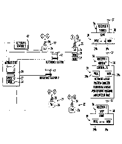
[0021] Referring initially to FIG. 1, there is illustrated
generally at 20 an enhanced LOng RAnge Navigation (eLORAN)
system that includes a plurality of eLORAN transmitter
stations 22, each including an eLORAN antenna 24 and eLORAN
transmitter 26 coupled to the eLORAN antenna and configured to
transmit data over an eLORAN data channel (LDC) and transmit a
series of LORAN navigation RF pulses. Four eLORAN transmitter
stations 22 are illustrated and labeled as TX1, TX2, TX3 and
TX4, and as shown in the example of the eLORAN transmitter
station 22 labeled TX2, each transmitter station includes a
respective processor 28 and memory 29. Each of the eLORAN
transmitter stations 22 is operatively connected to an eLORAN
control station 30 that includes a processor 32 and memory 34
coupled thereto and configured to generate station specific
eLORAN data and non-station specific eLORAN data that are
received by users operating eLORAN receiver devices 36, which
could be located in an aircraft, ship or terrestrial land
vehicle, and illustrated schematically with Receiver 1 in an
aircraft and Receiver 2 in a ship, and Receiver 3 in a land
mobile vehicle.
[0022] Each eLORAN receiver device 36 includes an eLORAN
receive antenna 37 and an eLORAN receiver 38 coupled to the
eLORAN receive antenna. A controller 39 is coupled to the
eLORAN receiver 38 and configured to cooperate with the
plurality of eLORAN transmitter stations 22 to determine an
CA 3072825 2020-02-17
eLORAN receiver position and receiver clock error corrected
from Additional Secondary Factor (ASF) data. This ASF data is
based upon different geographical positions and different
times such as different seasons and different times of day for
each different geographical position. The controller 39
includes a memory 39a configured to store the ASF data, and a
processor 39b operating with the memory as explained in
greater detail below. The controller 39 may be configured to
receive updated ASF data via a wireless data channel or via an
eLORAN data channel. Corrections may be based on at least one
interpolation from this ASF data.
[0023] The control station 30 is connected to at least one
eLORAN reference station 42, and at least one of the eLORAN
reference stations operates as a differential eLORAN reference
station. At least one of the reference stations 42 monitors
the LORAN navigation RF pulses and processes data related to
the RF pulses to determine ASF differential corrections and
transmit information regarding those navigation RF pulses to
the eLORAN control station 30 via the eLORAN data channel. In
this example as illustrated, the eLORAN system 20 includes
three eLORAN reference stations 42.
[0024] The eLORAN system 20 is a positioning, navigation
and timing (PNT) service used for aviation, maritime and land-
mobile vehicle navigation as well a fixed station timing for
users. As a location and timing system, it may complement the
Global Navigation Satellite Systems (GNSS). The eLORAN
transmissions are synchronized to an identifiable, publicly-
certified source of coordinated universal time (UTC)
independent of the GNSS, and thus, may operate independently
of the GNSS. The eLORAN system 20 includes the additional
eLORAN data channel on the transmitted signal, thus
distinguishing the eLORAN system from traditional LORAN-C
systems. This eLORAN data channel transmits application-
specific corrections, warnings and signal integrity
6
CA 3072825 2020-02-17
information, including station specific eLORAN data such as
station identification and differential eLORAN corrections and
non-station specific eLORAN data such as almanac information,
including reference station latitude, reference station
longitude, and a reference station correction list.
[0025] The eLORAN system 20 includes Primary Factor (PF)
data, Secondary Factor (SF) data, and Additional Secondary
Factors (ASF) data to allow optimum performance for eLORAN
receiver devices 36. The primary factor (PF) data accounts
for the time of propagation of the LORAN navigation RF pulses
through the atmosphere based on the speed of light in
atmosphere. The eLORAN system 20 provides a value of the
speed of light in the atmosphere usually at about 161,829
nautical miles/second, which is equivalent to about
299,707,308 meters per second. These values can vary slightly
depending on which value is used for speed of light and other
related variables, such as values supplied by the United
States Coast Guard. Alternative definitions may specify the
primary factor as a difference in propagation time between a
signal traversing through vacuum versus the atmosphere.
[0026] The secondary factor (SF) accounts for the
difference in propagation time for a LORAN navigation RF pulse
originating from an eLORAN transmitter station 22 and
propagating its signal over an all seawater path, rather than
through the atmosphere in the absence of seawater path. The
Additional Secondary Factor (ASF), on the other hand, is the
extra delay based on the time-of-arrival (TOA) of the LORAN
navigation RF pulses due to propagation over a non-homogenous,
rough land path, such as elevated terrain, as opposed to over
ocean water. This ASF delay can be significant and usually
each eLORAN receiver device 36 makes a rough estimate based on
stored ASF data stored at the receiver to achieve accuracy in
tens to hundreds of meters. The ASF data can vary spatially
and temporarily, and thus, ASF grid and differential LORAN
7
CA 3072825 2020-02-17
corrections are used to account for the temporal and spatial
variations. Differential LORAN corrections that are
established by the eLORAN reference stations 42, often are
used to compensate for the lack of accuracy with standard ASF
maps.
[0027] Usually a service provider publishes a table of
values as a map with an ASF grid for a nominal ASF to improve
the accuracy of eLORAN receiver devices 36. Each eLORAN
receiver device 36 includes an ASF grid stored in its memory
39a, indicating the relative local variations of the ASF
relative to the nominal value for the region, and may be
provided at intervals that are in the order of hundreds of
meters. The differential corrections received from the
reference stations 42 may be used to account for the residual
ASF that is not corrected for by the ASF grid when an eLORAN
receiver device 36 is in the vicinity of reference stations
42, for example, when located in a crowded metropolitan area
or an important seaport where numerous reference stations 42
would be incorporated into the eLORAN system 20.
[0028] Although the ASF data that an eLORAN receiver device
36 encounters in any given location provides some correction,
the ASF data used to supply this correction is highly
dependent on temporal factors that can fluctuate on a daily
(diurnal) and seasonal basis. Sparsely populated areas
typically will not incorporate eLORAN reference stations 42
with the result that many areas of the Continental United
States (CONUS) will have less accurate eLORAN position and
timing solutions. This is acceptable in some cases where
eLORAN positioning accuracy is less critical. This eLORAN
positioning accuracy is compromised since the same stored ASF
map for each eLORAN transmitter station 22 is used regardless
of the time of day or month of year, causing positioning
discrepancies that can be hundreds of feet, e.g., as much as
8
CA 3072825 2020-02-17
200 feet as shown in the graphs of FIGS. 2 and 3, and as much
as 1,200 feet as shown in the graph of FIG. 4.
[0029] Referring to FIGS. 2 and 3, there are illustrated
examples of the daily ASF variations that occur when
transmitting the RF navigation pulses from a fixed eLORAN
transmitter station 22, which is located in these examples at
Wildwood, New Jersey, and transmitting to Columbus, Ohio
(FIG. 2) and to Bangor, Maine (FIG. 3). One nanosecond of
time error in each graph corresponds to approximately one foot
of distance as a pseudo range error. Thus, a 200 nanosecond
error in a peak-to-peak daily (diurnal) variation corresponds
to a 200 foot pseudo range error. The graphs in FIGS. 2 and 3
correspond to the 2014 Federal Radio Navigation Plan, with the
daily ASF variation shown in FIG. 2 for November 2016, and in
FIG. 3 for April 2016.
[0030] Referring more specifically to FIG. 4, there are
illustrated examples of the daily (diurnal) and monthly ASF
variations from four eLORAN transmitter stations 22 located at
different locations identified as Seneca (A), Caribou (B),
Nantucket (C), and Carolina Beach (D). The graphs show the
comparisons in the daily and monthly ASF variations for the
signals received at one eLORAN receiver device 36. In this
example, one (1) nanosecond of time error also corresponds to
about 1 foot of distance or pseudo range error. This modeling
was based upon year 2007 daily and seasonal data. In the
graphs, a delay of about 1.2 microseconds corresponds to about
a 1,200 foot error in pseudorange as noted in the distance
between parallel lines extending on the uppermost graph line,
corresponding to the Seneca eLORAN transmitter station 22
site. The distance between the vertical lines corresponds to
a 24 hour daily ASF variation, which is expressed over the
full year to account for monthly and seasonal ASF variations.
The daily ASF variation is superimposed on a much more slowly
varying error that changes monthly and annually over the four
9
CA 3072825 2020-02-17
seasons of the year. For example, the winter season
corresponding to the beginning of each of the graphs has a
lower daily ASF value variation than the variation occurring
during the summer and fall seasons, which is higher as
illustrated. The ASF variation differs from one path to
another, for example, the Seneca and Caribou graphs (A and B)
corresponding to different terrains as compared to the graphs
for Nantucket and Carolina Beach (C and D), which have a
partial seawater path where ASF values in that case are zero
(0) over seawater. These ASF variations are a strong function
of the conductivity of the earth surface over which the LORAN
navigation RF pulses traverse. Thus, when the LORAN RF pulses
traverse over rocky terrain, the ASF variation would be
different than when the LORAN RF pulses traverse over rich
fertile farmland. Thus, there are visible magnitudes in
variation between the four curves in FIG. 4.
[0031] A similar comparison for daily and monthly ASF
variations is shown in the graphs of FIGS. 5A through 5D,
showing the graphs for the four transmitter stations of Seneca
(FIG. 5A), Caribou (FIG. 5B), Nantucket (FIG. 5C), and
Carolina Beach (FIG. 5D), with each graph depicting the
variation based on eLORAN receiver devices 36 located at the
Coast Guard Academy (CGA) and Goodspeed Airport (42B) in East
Haddam, Connecticut, and with respective curves labeled A and
B on these graphs. This modeling is based on year 2007 data.
[0032] In accordance with a non-limiting example, each
eLORAN receiver device 36 may include ASF correction curves,
e.g., look-up tables, stored in the memory 39a and
corresponding to the path from each eLORAN transmitter station
22. Data corresponding to these correction curves is used to
determine an eLORAN receiver position and receiver clock error
corrected from the ASF data, which is based upon the different
geographical positions at different times for each different
geographical position. This additional ASF data will
CA 3072825 2020-02-17
compensate for different times of day and different days and
seasons, such as each month, and the overall position accuracy
of an eLORAN receiver device 36 is improved when those dynamic
ASF corrections received from reference stations 42 are
unavailable or an eLORAN receiver device is outside the
reference station's effective coverage area, usually a circle
having a 30 to 35 kilometer radius. Instead of storing only a
single ASF map for each eLORAN transmitter station 22 within
each memory 39a of the eLORAN receiver device 36, a number of
ASF correction curves or look-up tables per eLORAN transmitter
station are stored in the memory of each eLORAN receiver
device. This data is usually loaded during device manufacture
at the factory, in order to reflect the daily and
seasonal/monthly changes to the static ASF values, but could
be uploaded to a receiver device 36 via a wireless channel or
eLORAN data channel.
[0033] Any data used to generate dynamic ASF corrections
would have been previously processed and recorded at every
reference station 42. For example, for each eLORAN
transmitter station 22, an eLORAN receiver at a reference
station device 36 could store the daily ASF corrections as
"deltas" in a look-up table for the fixed ASF map values.
There could be a single daily (diurnal) variation look-up
table for each eLORAN transmitter station 22 and provided for
each month of the year. Thus, the total quantity of storage
required in the receiver memory 39a would be reasonable and
not require an excess of data storage capacity. In the
absence of the dynamic ASF correction data provided by
reference stations 42, such as when the eLORAN receiver device
36 is located outside of a metropolitan area or an important
port area having many reference stations, the eLORAN position
and timing error performance can be significantly improved, as
compared to the positioning acquired at an eLORAN receiver
device 36 using only the single ASF map throughout the year.
11
CA 3072825 2020-02-17
The fixed ASF map and the multiple ASF correction curves
reflect the daily and monthly ASF changes for a given area.
The controller 39 may be configured to generate the eLORAN
correction based upon at least one interpolation from that ASF
data since that data will usually be obtained by accumulation
over a spaced grid pattern and over different times of day and
different seasons.
[0034] ASF data may also be received as updated data via
the wireless data channel or an eLORAN data channel and
operate as an update to the data that had been previously
stored during manufacture of the eLORAN receiver devices 36.
The monthly and daily ASF correction data can be accumulated
and calculated also based on periodic observations at all
reference stations 42 such that when an eLORAN receiver device
36 is outside the coverage area of a reference station, the
controller 39 chooses stored ASF correction data for each
eLORAN transmitter station 22 in view, and based on the
current season and time of day, uses that data to determine
the correct ASF value to be applied. These ASF maps can be
frequently updated as noted before and data redistributed via
a wireless data channel or the eLORAN data channel, including
use of WiFi, Bluetooth, cellular, USE and other communication
systems for greater accuracy. The previous systems, on the
other hand, used a single ASF map such as provided by the
United States Coast Guard. This one time single ASF map was
published as a text document and provided to receiver
manufacturers as a one-time load into memory.
[0035] There now follows further description for the
general operation of the eLORAN system 20 described above.
Common messages are transmitted from the eLORAN transmitter
stations 22 and may include encryption keys to encrypt
messages. These keys are typically changed frequently. In
some systems, the keys may be changed daily and in other
systems the keys may be changed even for different messages.
12
CA 3072825 2020-02-17
Common messages may also include receiver control messages,
broadcast messages and almanac information, which may include
reference station latitude, reference station longitude and
reference station correction lists. Other data in the common
messages may include station identification data, differential
eLORAN corrections, and the UTC time. The differential
corrections may include data related to time differential
corrections and position differential corrections.
[0036] The eLORAN system 20 includes accommodation for a
medium GRI (Group Repetition Interval), which corresponds to
the time duration of the sequence of pulses, and may include a
sequence of timing pulses as master and secondary pulses.
Generally, the group repetition interval corresponds to the
specified time interval for all eLORAN transmitter stations 22
of a chain to transmit their pulse groups. For each chain, a
minimum group repetition interval is selected of sufficient
duration to provide the time for each eLORAN transmitter
station 22 to transmit its pulse group and an additional time
period between each pulse group so that signals from two or
more transmitter stations do not overlap in time within the
coverage area. The group repetition interval is normally
calculated in units of tens of microseconds and given a whole
number designation as a standard. For example, the group
repetition interval having 69,950 microseconds corresponds to
the GRI referred to as "6995," which, for a certain
application of the LDC can produce 143 messages over two
minutes. This eLORAN data channel has a low data rate usually
of about 50 to 100 bits per second, depending on GRI value,
and provides these multiple messages to a user operating an
eLORAN receiver device 36 to support the accuracy, integrity
and availability requirements in the eLORAN system 20.
[0037] There now follows further details of the general
operation of the eLORAN system 20 with its plurality of eLORAN
transmitter stations 22, and their cooperation with the
13
CA 3072825 2020-02-17
reference stations 42. The eLORAN control station 30 and the
reference stations 42 do not interfere with the timing control
of any transmitted signals, and the reference stations 42 as
noted before may provide augmentation data and may provide
real-time corrections to published ASF (Additional Secondary
Factor) maps for a complete maritime or other terrestrial
coverage area, and provide ASF grid data with nominal
propagation corrections per eLORAN transmitter station 22.
Thus, a user operating one or more eLORAN receiver devices 36
may apply both the ASF's from the map and any differential
eLORAN corrections received over the eLORAN data channel to
improve positioning accuracy. An eLORAN reference station 42
will calculate and transmit phase (i.e., time) corrections
continuously. As noted before, the eLORAN system 20 signal
structure is between a 90 and 110 kHz frequency band and with
a pulse signal usually at about a 100 kHz carrier frequency.
The eLORAN signal usually has groups of eight to ten pulses
that are spaced about 1 millisecond in a TDMA structure. The
transmission of groups repeats every group repetition interval
(GRI). As many as five different eLORAN transmitter stations
22 may share the same group repetition interval to form a
chain with a master and secondary transmissions. The eLORAN
signal envelope shape identifies a reference of zero-crossing,
which is synchronized to the UTC. The transmitted signals may
be phase coded 0 or 180 for master/secondary identification
and mitigation against multiple hop sky waves.
[0038] As a
non-limiting example, those skilled in the art
will understand that different implementations of the eLORAN
data channel may exist, such as a three-state pulse position
modulation known as the Eurofix modulation system that is
standardized by the RTCM and ITU, a 9th pulse modulation
system or a 9th-10t1i pulse modulation system. The first two
modulation systems provide equal data bandwidth of
approximately 20 to 50 BPS, while the third provides
14
CA 3072825 2020-02-17
approximately 100 bps. All modulation systems are protected
by Reed-Solomon forward error correcting code to counter the
effects of noise. The Eurofix modulation system has a pulse
position modulation of pulses 3 . . . 8 by +1, 0, -1
microseconds, while the 9t1i and 9th - 10th pulse modulation
systems have the additional 9th or 9th and 10t1 pulses of 32
possible delay values between 0 and 158.75 microseconds. In
the Eurofix modulation system as noted before, the pulses are
pulse position modulated (ppm) plus or minus (one) 1
microsecond. There are about 729 possible modulation patterns
and the pulse position modulated encoding uses about 128 of a
possible 141 balanced patterns to represent 7 bits of data per
group repetition interval. The data rate may be about 70 to
175 bits per second based on the group repetition interval and
uses the Reed-Solomon forward error correction technique. In
an example, the Eurofix message length is fixed at about 210
bits having 37-bit words.
[0039] With the 9th pulse modulation system, the pulse is
inserted 100 microseconds after the 8th pulse and may use
32-state pulse-position modulation to encode the data at a
data rate of about 5 bits per GRI.
[0040] The eLORAN system 20 includes the differential
eLORAN corrections transmitted within the eLORAN data channel,
which may contain ASF phase correction data from a
differential eLORAN reference station 42. The almanac
information may include the reference station latitude,
reference station longitude, and a reference station
correction list as noted before. The reference station
correction list may have messages that contain the signal ID
codes for the corrections from a particular differential
eLORAN reference station 42.
[0041] In one example, as understood by those skilled in
the art, it is possible that the Eurofix modulation system may
have 56 bits as a DGPS message. A message may have 14 bits as
CA 3072825 2020-02-17
a cyclic redundancy check for data link integrity, and 140
bits for the Reed-Solomon parity. In addition, 210 bits may
correspond to 30 GRI's of 7 bits per message, and thus,
correspond to about 1.2 to about 3 seconds per message. The
9th pulse modulation system may have a 32 state pulse position
modulation (5 bits/GRI) corresponding to 3 bits phase and 2
bits envelope and phase.
[0042] In operation, the eLORAN receiver devices 36 will
have a position calculation based on three or more pseudo
ranges to three or more eLORAN transmitter stations 22. An
eLORAN receiver device 36 will measure the arrival times,
which convert to pseudo ranges by multiplication with the
signal's propagation velocity. It should be understood that
this propagation velocity is not equal to the speed of light
in a vacuum, but rather depends on the medium the signals
travel in and over, such as in atmosphere, over sea, over
land, or over mountains. The calculations take into effect
the true range, the primary factor (PF), the secondary factor
(SF), and the additional secondary factor (ASF), together with
the variation in those factors and any remaining measurement
errors. The receiver clock bias (i.e., time error) is
automatically determined as part of the position calculation
process. As noted before, the primary factor delay accounts
for the difference between propagation of the signal in the
earth's atmosphere as opposed to in free space and the
secondary factor delay accounts for signal propagation over
sea water, especially the ocean. The primary factor and
secondary factor are known and considered constant and an
eLORAN receiver 36 uses a model to calculate these delays as a
function of the estimated range from the receiver to the
transmitters.
[0043] The additional secondary factor (ASF) delay build-up
depends on the type of soil and other factors and is the total
cumulative delay the signal experiences over sections with
16
CA 3072825 2020-02-17
different ground conductivity. An ASF map may be provided for
an operating area as a grid with a survey of nominal ASF's for
each eLORAN transmitter station 22. By not taking the ASF's
into account, this could result in positioning errors of
several hundred meters to even kilometers. ASF's are
published as a map with an ASF grid for each eLORAN
transmitter station 22.
[0044] Many modifications and other embodiments of the
invention will come to the mind of one skilled in the art
having the benefit of the teachings presented in the foregoing
descriptions and the associated drawings. Therefore, it is
understood that the invention is not to be limited to the
specific embodiments disclosed, and that modifications and
embodiments are intended to be included within the scope of
the appended claims.
l
17
CA 3072825 2020-02-17