Note: Descriptions are shown in the official language in which they were submitted.
CA 03074698 2020-03-03
WO 2019/055122
PCT/US2018/042755
OFFLOAD ADJUSTMENT FOR SATELLITE IMAGE DIVERSITY
BACKGROUND
[0001]Remote sensing vehicles such as satellites are commonly used for
electro-optical, infrared, and RF imaging of the surface of celestial bodies,
such
as the earth. FIG. 1 illustrates one such system known in the prior art for
capturing swaths/images of a target surface of a celestial body. As a
particular
remote sensing vehicle orbits in a certain flight advancement velocity (i.e.,
illustrated by the V arrow), a sensor is pointed at Nadir (in elevation, or
along-
track, angle) and perpendicular to the flight direction. In a pushbroom
system,
the image sensor covers the entire cross-track dimension, whereas in a whisk-
broom system, the image sensor is scanned in the cross track direction rapidly
as the vehicle is travelling, usually more slowly, in the along-track
direction. In a
whisk broom scanning satellite, a mirror rapidly scans in the cross-track
direction to effectively point the sensor at a target surface for imaging. As
the
vehicle advances, the sensor captures swaths of the target surface area to
generate an image. Such whisk broom scanning is implemented with the
Visible Infrared Imaging Radiometer Suite (VIIRS) satellite-mounted sensor. A
VIIRS satellite sensor payload is a scanning radiometer that collects visible
and
infrared imagery and radiometric measurements of land, atmosphere,
cryosphere, and oceans. VIIRS data is used to measure cloud and aerosol
properties, ocean color, sea and land surface temperature, ice motion and
temperature, fires, and Earth's albedo, for instance. Climatologists use VIIRS
data to improve our understanding of global climate change.
[0002] As illustrated in FIG. I when collecting data or scanning at Nadir
elevation angle with such a remote sensing vehicle, a particular resulting
swath/image is bowtie-shaped (due to the curvature of the celestial body when
scanning at Nadir). Due to this bowtie shape, successive swaths 1 and 2 will
1
CA 03074698 2020-03-03
WO 2019/055122
PCT/US2018/042755
have a pixel underlap between the middle portion of such swaths 1 and 2, as
shown. Overlap is also prevalent at corner areas of the adjacent swaths 1 and
2, as shown. Both the underlap and overlap issues can be problematic when
stitching the swaths together to generate a desired image. In particular,
underlap results in incomplete coverage of the celestial body, leaving gaps in
collected data. There also exists issues with time delay and integration (TDI)
dwell when scanning at Nadir with the \AIRS satellite because of the
limitations
of the sensor platform being static relative to the host bus.
[0003] One solution to address these issues is to manually change the pointing
angle of the sensor platform during sensor integration to the satellite.
However,
this solves only the underlap issue, and does not address other issues such as
TDI being tied to the gross satellite bus motion. Another solution involves
changing the angular position of the Nadir deck while in orbit. Another
solution
involves changing the attitude of the satellite bus itself while in orbit.
Finally, yet
another solution involves changing the sensor itself, such as changing the
"heartbeat" master clock, scan rate, and/or optical design.
[0004] These prior solutions often result in unintended consequences or
transient behaviors of the satellite bus, and can make the scan-to-scan
(revisit)
and instrument-to-instrument comparisons less tractable. This is exacerbated
by the fact that the host bus typically has many other sensors on-board, so
changing the attitude of the host bus can negatively affect such ancillary
sensors.
BRIEF DESCRIPTION OF THE DRAWINGS
[0005]Features and advantages of the invention will be apparent from the
detailed description which follows, taken in conjunction with the accompanying
drawings, which together illustrate, by way of example, features of the
invention;
and, wherein:
[0006] FIG. 1 illustrates a method of collecting data from a target surface
with a
remote sensing vehicle as known in the prior art
2
CA 03074698 2020-03-03
WO 2019/055122
PCT/US2018/042755
[0007]FIG. 2 illustrates a method of collecting data from a target surface
with a
remote sensing vehicle in accordance with an example of the present
disclosure;
[0008]FIG. 3A illustrates a swath resulting from the method of FIG. 2 in
accordance with an example of the present disclosure;
[0009]FIG. 3B illustrates adjacent swaths resulting from the method of FIG. 2
in
accordance with an example of the present disclosure;
[0010J FIG. 4 illustrates a method of collecting data from a target surface
with a
remote sensing vehicle in accordance with an example of the present
disclosure;
[0011]FIG. 5 illustrates adjacent swaths resulting from a method of collecting
data from with a remote sensing vehicle in accordance with an example of the
present disclosure;
[0012]FIG. 6 illustrates adjacent swaths resulting from a method of collecting
data from with a remote sensing vehicle in accordance with an example of the
present disclosure;
[0013]FIGS. 7A-70 illustrate a method of continuous look-back scanning with a
remote sensing vehicle in accordance with an example of the present
disclosure;
[0014]FIGS. 8A-8C illustrate various swath shapes when collecting data with a
remote sensing vehicle in accordance with an example of the present
disclosure;
[0015]FIG. 9 illustrates geometric parameters when collecting data with a
remote sensing vehicle in accordance with an example of the present
disclosure;
[0016]FIGS. 10A and 10B are graphs showing various data when collecting
data with a remote sensing vehicle in accordance with an example of the
present disclosure;
[0017]FIG. 11 illustrates a gimbal system of a remote sensing vehicle in
3
CA 03074698 2020-03-03
WO 2019/055122
PCT/US2018/042755
accordance with an example of the present disclosure;
[0018]FIG. 12 illustrates payload pointing adjustments in accordance with an
example of the present disclosure; and
[0019] FIG. 13 illustrates a method of operating a remote sensing vehicle in
accordance with an example of the present disclosure.
[0020]Reference will now be made to the exemplary embodiments illustrated,
and specific language will be used herein to describe the same. It will
nevertheless be understood that no limitation of the scope of the invention is
thereby intended.
DETAILED DESCRIPTION
[0021]As used herein, the term "substantially" refers to the complete or
nearly
complete extent or degree of an action, characteristic, property, state,
structure,
item, or result. For example, an object that is -substantially" enclosed would
mean that the object is either completely enclosed or nearly completely
enclosed. The exact allowable degree of deviation from absolute completeness
may in some cases depend on the specific context. However, generally
speaking the nearness of completion will be so as to have the same overall
result as if absolute and total completion were obtained. The use of
"substantially" is equally applicable when used in a negative connotation to
refer
to the complete or near complete lack of an action, characteristic, property,
state, structure, item, or result.
[0022]As used herein, "adjacent" refers to the proximity of two structures or
elements. Particularly, elements that are identified as being "adjacent" may
be
either abutting or connected. Such elements may also be near or close to each
other without necessarily contacting each other. The exact degree of proximity
may in some cases depend on the specific context.
[0023]An initial overview of the inventive concepts are provided below and
then
specific examples are described in further detail later. This initial summary
is
intended to aid readers in understanding the examples more quickly, but is not
4
CA 03074698 2020-03-03
WO 2019/055122
PCT/US2018/042755
intended to identify key features or essential features of the examples, nor
is it
intended to limit the scope of the claimed subject matter.
[0024]Generally speaking, the present technology offloads scan coverage,
areal coverage, pixel size determination, integration time, look angle, and
variability in each of these parameters as a function of time or satellite
location,
such that these are handled off-sensor and off-satellite-bus. The offload
consists of an interface with static or dynamic tip or tip-tilt capability,
such that
the entire sensor can be rotated as a solid-body rotation. Thus, the entire
sensor can be back-scanned synchronous with the satellite forward advance in
order to dwell on a particular region of interest or to precisely effect TDI.
Similarly, an interesting area or feature can be revisited in transit by
pitching
back or forward the entire sensor without interfering with the satellite bus.
Collecting data (e.g., scanning) with a constant angle from Nadir can be
chosen
to increase FOV in the along-track direction; and tilting along with tipping
can be
used to define ground-step distance (GSD) along-track and cross track
resolution, allowing selection of pixel size in each dimension separately,
even
dynamically changed across-track in a whisk-broom system. All of this can be
carried out in a manner, such that the sensor algorithms and the vehicle bus
parameters are not impacted.
[0025]In one example there is provided a method of decoupling payload
pointing from a host bus platform. The method comprises operating a remote
sensing vehicle comprising a host bus platform and a variable pitch instrument
platform. The variable pitch instrument platform is moveably coupled to the
host
bus platform in at least one degree of freedom. The method comprises
.. establishing a pointing position of the variable pitch instrument platform,
and
collecting data from a target surface with the variable pitch instrument
platform
at a first pitch angle relative to Nadir to generate a first data set
(corresponding
to a generated first image). Thus, payload pointing is decoupled from the host
bus platform attitude. In addition, pixel size, integration time, etc. can be
decoupled from the single design point defined by the orbit and scan speed.
[0026]In one example, the method comprises moving or otherwise manipulating
5
CA 03074698 2020-03-03
WO 2019/055122
PCT/US2018/042755
the variable pitch instrument platform relative to the host bus platform to
vary
the pointing position of the variable pitch instrument platform. The method
can
further comprise collecting data from the target surface with the variable
pitch
instrument platform at a second pitch angle relative to Nadir to generate a
second data set (corresponding to a generated second image).
[0027] I n one example, establishing pointing angles to the target surface
with
the variable pitch instrument platform off-loads payload pointing from the
host
bus platform.
[0028] In one example, modifying the pointing position of the variable pitch
instrument platform facilitates dynamic control of pixel shape and size of at
least
one of the first and second data sets.
[0029] In one example, the method comprises repeatedly collecting data from
the target surface at the first pitch angle to generate a plurality of
successive
images (from successive collected data sets), wherein adjacent images of the
plurality of successive images have overlapping pixels.
[0030]In one example, the method comprises remotely controlling the pointing
position and roll angle of the variable pitch instrument platform from a
remote
location.
[0031] In one example there is provided a method of varying ground-sample-
distance (GSD) value with a remote sensing vehicle. The method comprises
operating a remote sensing vehicle comprising a variable pitch instrument
platform and a host bus platform. The variable pitch instrument platform is
movably coupled to the host bus platform in at least one degree of freedom.
The method comprises collecting data (e.g., scanning) from a target surface
with the variable pitch instrument platform at a first pitch angle relative to
Nadir
to generate a first data set. The method comprises varying a pointing position
of the variable pitch instrument platform by moving or otherwise manipulating
the variable pitch instrument platform relative to the host bus platform. The
method comprises collecting data from the target surface with the variable
pitch
instrument platform at a second pitch angle to generate a second data set,
6
CA 03074698 2020-03-03
WO 2019/055122
PCT/US2018/042755
thereby varying a GSD value.
[0032] In one example, the method comprises synchronizing or otherwise
coordinating the second pitch angle with a relative velocity (or other
movements) of the remote sensing vehicle, such that the first and second
images (from first and second data sets) are substantially similar, and
without
modifying the attitude of the host bus platform.
[0033] In one example there is provided a remote sensing vehicle comprising a
host bus platform; a variable pitch instrument platform comprising a detector
for
collecting data from a target surface; and a dynamic coupling device movably
coupling the variable pitch instrument platform to the host bus platform in at
least one degree of freedom. The variable pitch instrument platform is movable
relative to the host bus platform to establish a pointing position of the
variable
pitch instrument platform, such that payload pointing is decoupled from the
host
bus platform attitude, and such that the payload data collection is
independent
of attitude control or other movement of the host bus platform.
[0034] In one example, the dynamic coupling device comprises a gimbal system
that facilitates movement of the variable pitch instrument platform relative
to the
host bus platform.
[0035] In one example, the detector of the variable pitch instrument platform
is
configured to generate a first data set when in a first pitch angle position,
and to
generate a second data set when in a second pitch angle position, upon
movement of the variable pitch instrument platform relative to the host bus
platform.
[0036] In one example, the variable pitch instrument platform is configured to
be
dynamically moved relative to the host bus platform during orbit to modify a
pitch angle of the variable pitch instrument platform, thereby varying a GSD
value between successive adjacent images gathered by the detector of the
variable pitch instrument platform.
[0037] To further describe the present technology, examples are now provided
with reference to the figures.
CA 03074698 2020-03-03
WO 2019/055122
PCT/US2018/042755
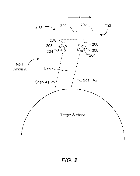
[0038] FIG. 2 illustrates a method of decoupling payload pointing from a host
bus platform attitude of a remote sensing vehicle in accordance with an
example
of the present disclosure. In one aspect, a remote sensing vehicle 200
comprises a host bus platform 202 and a variable pitch instrument platform 204
having one or more imaging sensors (e.g., a detector) 206 for scanning or
collecting data from a target surface (e.g., a celestial body such as earth).
The
remote sensing vehicle 200 can be similar to the \AIRS satellite discussed
above (e.g., a whisk or push broom scanning satellite at low orbit). However,
this is not intended to be limiting in any way. The variable pitch instrument
platform 204 can comprise a number of components for scanning a target
surface, such as a rotary solenoid, a rack-and-pinion actuator, a flexure
mount,
a four-bar linkage, or many other options known to practitioners skilled in
mechanical designs of mechanisms.
[0039]As mentioned above, the remote sensing vehicle 200 can be a whisk
broom scanning satellite, such at a VIIRS satellite. Whisk broom scanning will
not be discussed in detail, however some background and detail is provided. As
with known whisk broom scanning satellites, scanning with a detector is
generally orthogonal to the direction of motion of the satellite (e.g., at
Nadir
elevation angle). The detector imaging will have a 360 degree spin rate about
the satellite such that, when the detector "sees" the target surface during
its spin
cycle, the detector collects data or images the target surface. Hence the
analogy to a whisk broom that whisks back and forth over an area. Such
scanning is often referred to as "the heartbeat" of the detector. Of course,
the
detector is not always physically spinning itself, rather a mirror moves or
rotates
to reflect radiation to the detector during normal scanning operations. Such
"heartbeat" of the detector can be timed with the velocity of the satellite.
The
detector 206 of the present disclosure can comprise similar detectors as that
of
known VIIRS satellites, or other detectors as will be recognized by those
skilled
in the art. However, as discussed below, unlike prior systems and methods,
scanning with the detector 206 of the present technology can be carried out
such that the scanning is not orthogonal to the orbit direction of the
satellite.
8
CA 03074698 2020-03-03
WO 2019/055122
PCT/US2018/042755
That is, scanning/pointing with the detector 206 can be carried out
dynamically
in a pitched back or pitched forward manner.
[0040]Alternatively, the remote sensing vehicle 200 (and its detector 206) can
operate in a push broom scanning manner such that, at any time only certain
points are imaged that lie in the plane defined by the optical center and the
line
containing the sensor array. That is, the detector 206 may have an array of
CODs along an imaging plane. This plane is known as the instantaneous field
of view (IFOV) plane. Accordingly, as the vehicle 200 advances forward, a
linear array of sensors (CODs) simultaneously capture images of the target
surface for electro-optical, infrared, and RF imaging of the target surface.
Hence the analogy to "push brooms".
[0041] Whether the detector 206 is configured in a whisk broom or push broom
scanning configuration, the variable instrument platform 204 is dynamically
movable to modify the pointing position of the variable instrument platform
204
(and consequently the detector 206) relative to the host bus during flight or
orbit.
More specifically, a dynamic coupling device 208 movably couples the variable
pitch instrument platform 204 to the host bus platform 202 in at least one
degree
of freedom (an example of a dynamic coupling device will be discussed further
regarding FIG. 11). Accordingly, the variable pitch instrument platform 204 is
.. movable relative to the host bus platform 202 to establish (and modify) a
pointing position of the variable pitch instrument platform 204, and
consequently
boresight of the detector 206. Thus, because the pitch instrument platform 204
is movably coupled to the host bus platform 202, payload pointing is decoupled
from the attitude of the host bus platform 202 in that the payload data
collection
(via detector 206) is independent of attitude or other movement control of the
host bus platform 202. More specifically, as discussed in the background
section above, prior systems require changing the attitude of a host bus in
order
to control or change the pointing position of a detector or sensor platform,
which
affects various other systems and sensors of the host bus. In the present
example, because the variable pitch instrument platform 204 is movable
relative
to the host bus platform 202, the variable pitch instrument platform 204 can
be
9
CA 03074698 2020-03-03
WO 2019/055122
PCT/US2018/042755
moved relative to the host bus platform 202 during orbit to dynamically
establish
(and modify) a pitch angle and pointing position of the variable pitch
instrument
platform 204 relative to Nadir without impacting a current orbit attitude of
the
host bus platform 202.
[0042] Establishing an initial pointing position can occur during manufacture
and/or maintenance, such as by manually/locally setting the variable pitch
instrument platform 204 to be at a desired pitch angle via the dynamic
coupling
device 208 relative to the host bus platform 202. Alternatively, establishing
the
pointing position can occur during orbit by actuating (autonomously or
manually)
the variable pitch instrument platform 204 to be rotated and/or panned about
the
dynamic coupling device 208 to a desired pitch angle. In one example, the
pitch
angle A of FIG. 2 can be between 5 and 20 degrees relative to Nadir. In the
illustrated example, the variable pitch instrument platform 204 is pitched
back to
a look-behind angle. However, the variable pitch instrument platform 204 can
be pitched forward to a look-ahead angle. In any event, the pitch angle can be
a few degrees in either direction and up to an angle associated with the
horizon.
Example mechanisms for actuating or moving the variable pitch instrument
platform 204 are further discussed regarding FIG. 11.
[0043] Wth reference to FIGS. 3A and 3B, and continued reference to FIG. 2,
once the initial pointing position is established (e.g., pitch angle A) the
target
surface can be scanned (scan Al) by the detector 206 of the variable pitch
instrument platform 204. FIG. 3A shows a captured swath SA1 upon such first
scan at the first pitch angle A, which, advantageously, is in the shape of a
meniscus. As illustrated in FIG. 2, as the remote sensing vehicle 200 advances
forward (to the right) during orbit, a second scan SA2 is captured (at the
same
first pitch angle A) of the target surface by the detector 206. As expected,
swath
SA2 is also in a similar shape of a meniscus as swath SA1. As a result, and as
shown in FIG. 3B, the successive/adjacent swaths SA1 and SA2 have a pixel
overlap region 0 along the continuous arced sides of the respective swaths Ski
and SA2. Notably, there is no underlap between adjacent swaths, such as
occurs when scanning at Nadir (FIG. 1) with prior known remote sensing
CA 03074698 2020-03-03
WO 2019/055122
PCT/US2018/042755
vehicles.
[0044] Pitch-back scanning (as in FIG. 2) and pitch-forward scanning can
provide more areal coverage than a simple Nadir scan, which eliminates the
aforementioned under scan coverage of the target surface, as well as defining
the shape and IFOV of pixels of adjacent swaths. Because the variable pitch
instrument platform 204 is movably coupled to the host bus platform 202, the
variable pitch instrument platform 204 can be pitched forward at a certain
angle
in a similar manner as exemplified regarding FIG. 2, and it can generate
successive swaths as in FIG. 3B, but with a mirrored meniscus shape. Thus,
establishing pointing angles to the target surface with the variable pitch
instrument platform 204 off-loads payload pointing from the host bus platform.
[0045] In one aspect where the detector 206 is in a push broom configuration
on
the variable pitch instrument platform 204, it can similarly be pitched
forward/back to look ahead/behind during push broom scanning, and the swaths
will have a similar shape and overlap as shown on FIG. 3B during pitch-back
scanning, for example.
[0046] With reference to FIG. 4, the variable pitch instrument platform 204
can
be dynamically moved during orbit to fit a particular purpose and provide
certain
advantages, such as those discussed herein. At the outset, and in one
example, the variable pitch instrument platform 204 can be pitched-back at
pitch
angle B and perform scan B. In this example assume that the pitch angle B is 5
degrees back relative to Nadir. Upon performing scan B, a resulting swath SB
is
generated (as shown in FIG. 5). As illustrated in FIG. 4, as the remote
sensing
vehicle 200 advances forward (to the right) during orbit, the variable pitch
instrument platform 204 can be moved (rotated and/or panned) to a second
pitch angle C (e.g., 10 degrees relative to Nadir) via the dynamic coupling
device 208. Thus, after the pointing position of the detector 206 is adjusted
to a
desired position (i.e., pitch angle C) by moving the variable pitch instrument
platform 204 via the dynamic coupling device 208, a second scan can be
performed at pitch angle C of the target surface by the detector 206 to
generate
a second swath SC. In some aspects, movement of the variable pitch
11
CA 03074698 2020-03-03
WO 2019/055122
PCT/US2018/042755
instrument platform 204 can be coordinated with and correspond to the orbital
height or altitude, velocity, etc. of the remote sensing vehicle 200 to
achieve
and/or maintain a desired pointing position or pitch angle.
[00471As a result and as shown in FIG. 5, the successive/adjacent swaths SB
and SC have a substantial amount of pixel overlap 0 along side pixel areas of
the swaths SB and SC. And as another result, a ground scan distance (GSD)
value between the swaths SB and SC is relatively short (as compared to the
swaths of FIG. 3B, for example, where the pitch angle remained constant
between scans). Accordingly, a relatively large area of the target surface can
be
re-scanned (or continuously scanned) during orbit with the variable pitch
instrument platform 204 by modifying the pitch angle independent of attitude
control and orientation of the host bus platform 202. Thus, payload pointing
is
offloaded from the host bus platform 202 to the variable pitch instrument
platform 204. By offloading the payload pointing, the variable tip-tilt
instrument
platform facilitates de-coupling such payload pointing from the scanning, the
optical design, and the timing chain at the higher-bandwidth domain, of the
variable pitch instrument platform 204 and its detector 206. Scanning usually
occurs in a repetitive manner with control and time constants that are more
rapid than bulk pointing excursions. By offloading the large whole-instrument
motions that occur at a lower bandwidth, coupling into the control sequence is
avoided, as are the possibility of interrupt errors in the control logic.
Similarly,
by avoiding changes to the optical prescription, offloading pointing to an
external
mechanism minimizes possibility of unintended consequences. Furthermore,
allowing in-flight adjustments to payload pointing and field-of-view (F0V)
relaxes
assembly tolerances and reduces time spent and cost in the alignment and test
phase.
[0048] Referring again to FIG. 4, in one example illustrating the advantage of
dynamic control of the variable pitch instrument platform 204, during pitch-
back
scanning at pitch angle B, if scan B captures an event or area of interest it
could
be desirable to scan the same target surface location in order to re-scan the
event or area of interest. Alternatively, it could also be desirable to
dynamically
12
CA 03074698 2020-03-03
WO 2019/055122
PCT/US2018/042755
modify the pointing position of the variable instrument platform 204 during
scanning (or collecting data) to continuously scan the same target surface
location of the event or area of interest (e.a., see the discussion regarding
FIGS.
7A-8C). However, in such a case it would be beneficial not to have to adjust
the
attitude of the host bus platform 202 because its numerous instruments/sensors
may be negatively affected and need adjustment (whether in real-time or pre-
programmed). This could over constrain the operation of the satellite and the
sensors as a whole. Conversely, with the technology disclosed herein, the
variable pitch instrument platform 204 can be moved in a dynamic manner (i.e.,
in real-time as the host bus platform 202 orbits) to modify the pointing
position of
the detector 204 to scan at pitch angle C (or continuously scan at pitch angle
B
in a push broom configuration) to scan the same area of interest of the target
location for as long as possible without altering the attitude, orientation,
etc. of
the host bus platform 202. Again, the dynamic control and movement of the
variable pitch instrument platform 204 can be coordinated with or correspond
to
the orbital parameters of the remote sensing vehicle 200 and the host bus
platform 202. For example, in the case of the host bus platform 202 being in
the
form of a satellite, as the satellite orbits at a given velocity and at a
given
altitude and in a given direction, the variable pitch instrument platform 204
can
be caused to move, such that the target surface location is scanned, rescanned
or continuously scanned as desired. Indeed, the pitch angle, the yaw angle, or
any other movements in the degrees of freedom available in the variable pitch
instrument platform 204 can be caused to change relative to the satellite and
as
the satellite moves relative to the target surface location.
[0049]Advantageously, the example of FIGS. 4 and 5, for instance, allows for
real-time adjustment of pixel resolution and object (e.g., Earth) coverage, as
well as facilitating manipulation of the shape, size, and skewness of the
particular swath/projection. Resolution, for example, is impacted by pitch
forward or back in elevation, whereas shape and skewness can be affected
locally by roll, tip, and tilt. This allows higher band-to-band registration
between
pixels in adjacent spectral bands.
13
CA 03074698 2020-03-03
WO 2019/055122
PCT/US2018/042755
[0050] Moreover, typically, as a satellite orbits around a celestial body it
will
continually degrade toward the celestial body (i.e., it constantly loses
altitude
due to being subject to the slight gravitational pull that exists within a low-
earth
orbit). Using prior scanning systems that are coupled directly to the host bus
platform, such degradation can pose complications to various other systems of
the satellite, particularly in the event that the attitude of the entire host
bus
platform is altered in order to account for the degradation and to perform a
desired scanning function, such as would be the case when the pointing
position of one of the detectors is changed by altering the attitude of the
satellite. As indicated, this type and method of altering pointing position
can
cause other systems on the satellite or host bus platform to be over
constrained.
On the other hand, with the present technology described herein, because the
detector 206 is effectively decoupled from the systems of the host bus
platform
202, degradation can be accounted for by slightly and constantly moving the
variable pitch platform 204 accordingly and as needed during degradation,
which movement can be accomplished independent of the host bus platform
202.
[0051] Wth continued reference to FIGS. 2 and 4, and with reference to FIG. 6,
illustrated is an example method of varying a GSD value via the remote sensing
vehicle 200. In this example, swaths SD and SE are successive swaths
captured at a first pitch angle (e.g., similar to FIGS. 2 and 38). This
defines a
first GSD value between swath SD and SE, labeled as GSD1, which, for
example, can be approximately 11 km (see the below table). The pointing
position of the variable pitch instrument platform 204 can then be varied or
modified by moving the variable pitch instrument platform 204 relative to the
host bus platform 202 at a second pitch angle different from the first pitch
angle,
as described above with reference to the example of FIG. 4. That is, the
second
pitch angle (e.g., 10 degrees) would be greater than the first pitch angle
(e.g., 5
degrees) during a pitch-back scanning operation. Thus, swath SF is generated
upon scanning with the detector 206 at the second pitch angle, which defines a
second GSD value between swath SE and SF, labeled as GSD2 (e.g., a 5 km
14
CA 03074698 2020-03-03
WO 2019/055122
PCT/US2018/042755
GSD2). In this example, GSD1 is greater than GSD2. Therefore, a particular
GSD value can be varied between adjacent swaths by modifying the pointing
position of the detector 206 upon moving the variable pitch instrument
platform
204 independent of attitude control the host bus platform 202. This is
advantageous to dwell on an evolving scene such as the eye of a hurricane or a
rapidly advancing forest fire front, as well as to allow increased signal-to-
noise
ratio (i.e. image clarity) for a static scene, or decoupling TDI from forward
speed
of advance of the satellite bus. This, in turn, could allow use of a lower
cost
sensor in the design phase.
[0052] FIGS. 7A-70 illustrate the advantages of TDI dwell when continuously
look-back scanning by modifying the pointing position of the variable pitch
instrument platform 204 during scanning of (or collecting data from) a target
surface. More specifically, FIG. 7A shows the remote sensing vehicle 200
scanning target surface area or location 2 at Nadir (i.e., generating
swaths/image of the target surface). As the remote sensing vehicle 200
advances forward as illustrated in FIG. 7B, the variable pitch instrument
platform
204 can be adjusted or moved (as discussed above) to be pitched-back relative
to the velocity of the remote sensing vehicle 200 to continuously scan the
target
surface area 2 for a predetermined time period. Thus, such movement to pitch-
back the variable pitch instrument platform 204 is synchronized with or made
to
correspond to the velocity of the remote sensing vehicle 200 during orbit. As
shown in FIG. 7C, the variably pitch platform 204 can further be configured to
quickly snap/move forward to scan target surface area or location 3 at Nadir.
Such slow look-back and fast snap-forward illustrated in FIGS. 7A to 7C can
improve or maximize TDI dwell, which can provide more dwell time for each
pixel row (or target surface area) during scanning as there is less transition
time
between rows (areas). In addition, with a wider image sensor, a longer GSD
plus the dwell plus snap-back allows greater signal-to-noise ratio, allowing
lower-performance (perhaps uncooled saving size, weight, and power) to be
used with similar image quality to systems not using this scheme. This
facilitates payload persistence of the variable pitch instrument platform 204
on a
CA 03074698 2020-03-03
WO 2019/055122
PCT/US2018/042755
fixed point without affecting satellite bus transit and mission parameters,
for
instance.
[0053]FIGS. 8A-8C illustrate the advantages of pixel projection versatility
when
looking-back and rotating the variable pitch instrument platform 204 (i.e.,
using a
variable pitch instrument platform 204 configured and operable to move in two
degrees of freedom) during a scanning event by modifying the pointing position
of the variable pitch instrument platform 204. More specifically, FIG. 8A
shows
an example Nadir scan swath A. and FIG. 8B shows an example look-back scan
swath B in the shape of a meniscus as the result of moving (i.e., pitching
back)
the variable pitch instrument platform 204. When overlaying swath A and swath
B to observe an area of interest H, for instance, the pixel overlay is not
ideal
because of the distortion of the relative pixels, due to the shape of swath B.
However, in this example, and with reference to FIG. 8C, the variable pitch
instrument platform 204 can be caused to both pitch-back and rotate or roll
about the look axis, for example (i.e., rotate about two axes to achieve
rotation
in at least 2 degrees of freedom to change the sensor FOV) to generate look-
back scan swath C. Effectuating movement of the variable pitch instrument
platform 204 this way results in improved pixel projection overlay at the area
of
interest H during dwell because the pixels are better aligned between the
Nadir
scan swath A and the look-back scan swath C. This occurs because the
projection of a pixel on a curved surface results in a skewed rhomboid shape
which can be partially correct with the technology discussed herein. This can
improve accuracy of scene evaluation in a select optimized region.
[0054]FIG. 9 illustrates geometric parameters for operating the remote sensing
vehicle 200 as pertaining to pitching forward the variable pitch instrument
platform 204 in accordance with an example of the present disclosure. It
should
be appreciated that the principles discussed as follows will be similar for
pitching-back the variable pitch instrument platform 204.
[0055]The below table shows one example of values pertaining to operating a
remote sensing vehicle (e.g., 200, 250) and a movably coupled variable pitch
instrument platform (e.g., 204, 254) as exemplified above and regarding FIG.
11
16
CA 03074698 2020-03-03
WO 2019/055122
PCT/US2018/042755
below.
Parameter Units Value
Satellite altitude (h) km 823
Orbit i nd nati on angle deg 8.65
Earth gravity constant m"3/s"2 3.99E+14
Earth radius (R) km 6378.14
Orbital period s 6087.9
Satellite angular velocity mrad/s 1032
Earth surface velocity at equator km/s 0.464
Track velocity km/s 6.583
Track velocity ECR krnis 6668
Telescope scan rate rad/s 3.53
Telescope scan period s 1780
Track motion per scan km 118E0
Pixel pitch mm 1016
Number of pixel in band 16
Focal length mm 1141
IFOV rrrad 0.891
FOV rrraci 14.253
GFOV at Nadir km 11.8)1
Overlap bet/teen scans at Nadir km -0.068
Look ahead/behind angle (0) deg 10
a deg Z9454
deg 0.0217
Effective altitude (h) km 840.92
GFOV at look angle km 119E5
Overlap bet/teen scans at look-ahead km 0.116
(0056] In this example, the remote sensing vehicle has an altitude (height h)
of
828 km in a typical low-earth orbit (LEO orbit). The height can vary, such as
between low-earth and high-earth orbits. Notably, the remote sensing vehicle
can be designed for a relatively low altitude orbit, as with many VI IRS
satellites.
The orbit inclination angle is approximately 8.56 degrees as a deviation from
true polar orbit to maintain a sun-synchronous orbit path. Of course, the
earth
radius R is about 6378 km. The orbit period of the remote sensing vehicle is
approximately 6088 seconds, and the angular velocity is 1.032 mrad/s. The
travel velocity is approximately 6.583 km/s, and the track velocity Earth
17
CA 03074698 2020-03-03
WO 2019/055122
PCT/US2018/042755
Coordinate Reference is approximately 6.668 km/s. In one example, the
detector scan rate is 3.53 radls in a whisk broom configuration, but that can
vary
depending on the focal plane array parameters of the detector. The scan period
is 1.78 seconds, and the track motion per scan is approximately 11.869 (i.e.,
distance on target surface between successive scans/swaths. The pixel pitch is
approximately 1.016 mm, which is the distance between pixels, and the number
of pixels in the band is approximately 16 pixels. In one example, the focal
length is 1141 mm, and the IFOV is approximately 0.891 mrad (the
instantaneous IFOV of 1 pixel). Thus, the FOV is 12.253 mrad, and the ground
FOV at Nadir is approximately -0.068 km. In one example, the look
ahead/behind angle (0) (line of sight angle) is 10 degrees, but it can vary,
such
as between 0 degrees and the number of degrees to reach horizon h' in either
the forward or rearward direction in some examples.
[0057] In one example, the ground point angle (a) is approximately 2.9454
between the remote sensing vehicle 200 and Nadir. The center of earth angle
(y) is approximately 0.0217 between ground point and Nadir. Thus, the
effective altitude (h') is approximately 840.92km, which is an increased
optical
path length from look-ahead angle. The ground FOV angle is approximately
11.985. In one example, the overlap between scans is approximately 0.116,
which can be applied to the overlap 0 described regarding FIG. 3B. Of course,
the above example parameters will vary depending on the altitude of the remote
sensing vehicle (and various other factors), as will be apparent to those
skilled
in the art.
[0058] Note that the remote sensing vehicle examples discussed herein are not
limited to low altitude orbit, and they can be operated at geostationary orbit
(approximately 35,000 km elevation), or even HEL orbit. Further note that the
remote sensing vehicle examples discussed herein can further collect data
corresponding to RF communication links, synthetic-aperture radar (SAR),
and/or other known technologies usable with such remote sensing vehicles for
collecting data pertaining to any celestial body. And, in some examples, the
remote sensing vehicle examples discussed herein could be any unmanned
18
CA 03074698 2020-03-03
WO 2019/055122
PCT/US2018/042755
aerial vehicle (UAV), such as high-altitude long-endurance (HALE) UAVs, or
lighter-than-air surveillance vehicles and platforms, all of which can operate
at
relatively low orbits for collecting data utilizing the devices and methods
discussed herein regarding the remote sensing vehicle examples.
[0059]FIGS. 10A and 10B are graphs that illustrate correlations associated
with
operating a remote sensing vehicle (e.g., 200, 250) as exemplified above and
regarding FIG. 11 below. In one example, as shown in FIG. 10A, as the look-
ahead (or behind) angle increases from 0-10 degrees, the swath coverage
increases slightly exponentially (due to the curvature of the earth). At a 5
degree pitch angle, a 0.05 km increased coverage distance is obtained, and at
a
10 degree pitch angle, a 0.18 km increase coverage distance is obtained. FIG.
10B illustrates swath patterns for 0, 5 and 10 degree look-ahead angles. At 5
degrees, the scan/swath (km) coverage increases as horizontal sampling
interval (HSI) track (km) increases. And at 10 degrees the scan/swath coverage
increases as HSI track increases, but to a greater extent than when looking at
10 degrees. The pitch angle may be greater than 10 degrees, such as when
orbiting at a lower altitude than exemplified above.
[0060]FIG. 11 illustrates an example of a dynamic coupling device (e.g., the
dynamic coupling device 208 discussed above) that movably couples a variable
pitch instrument platform (e.g., the variable pitch instrument platform 204
discussed above) to a host bus platform (e.g., the host bus platform 202
discussed above). In the illustrated example, a remote sensing vehicle 250
comprises a host bus platform 252 and a variable pitch instrument platform
254.
The variable pitch instrument platform 254 can comprise and support a detector
256, such as detector 206 described above. A line of sight of the detector 256
can be adjusted or moved in a variety of different ways to achieve In one
example, the variable pitch instrument platform 254 can comprise an adjustable
optical device 255 positioned in an optical path with and adjacent the
detector
256. The adjustable optical device 255 can be configured to be dynamically
moveable to adjust a line of sight of the detector 256 (i.e., intra-payload
line of
sight adjustment). The adjustable optical device 255 can be an adjustable
tip/tilt
19
CA 03074698 2020-03-03
WO 2019/055122
PCT/US2018/042755
mirror or an adjustable decenter lens configured to modify boresight of the
detector 256, similar to optical image stabilization, as illustrated by the
rotational
arrows. The adjustable optical device 255 can be mounted using well
established mechanisms and methods as will be apparent to those skilled in the
art.
[0061]In another example, the dynamic coupling device (e.g., 208) can
comprise a gimbal system 260 that facilitates movement of the variable pitch
instrument platform 254 relative to the host bus platform 252. Specifically,
the
gimbal system 260 can comprise a plurality of rotatable gimbal devices 262,
264, and 266 to facilitate rotation of the variable pitch platform 254 in at
least
one, and up to three, rotational degrees of freedom, wherein such movement is
relative to the host bus platform 252. For instance, a pair of first gimbal
devices
262 can be configured to provide rotation of the variable pitch instrument
platform 254 about an axis Y (a horizontal axis when viewing FIG. 11) with any
desired number of degrees of movement or adjustment relative to the host bus
platform 252. To this end, a first support structure 270 can be rotatably
coupled
to a second support structure 272 by the pair of first gimbal devices 262.
Gimbaled devices could be as simple as nested hinged brackets or more
complex, such as sleeved bearings with cross-roll axes. As shown, the first
support structure 270 can be configured to structurally support the variable
pitch
instrument platform 254 via mounts 274, which can comprise various fasteners
or other mounting hardware.
[0062]A second gimbal device 264 can be configured to provide rotation of the
variable pitch instrument platform 254 about an axis X (a vertical axis when
viewing FIG. 11) with any desired number of degrees of movement or
adjustment. Gimbal device 264 can comprise a cylindrical drum or disc that
rotatably couples the second support structure 272 to a third support
structure
276.
[0063] A pair of third gimbal devices 266 can be configured to provide
rotation
(e.g., tilt) of the variable pitch instrument platform 254 about an axis Z (an
axis
extending into and out of the page when viewing FIG. 11) with any number of
CA 03074698 2020-03-03
WO 2019/055122
PCT/US2018/042755
degrees of movement or adjustment. In one example, a third gimbal device
could be coupled proximate gimbal devices 266 (between structures 276 and
278) to provide three degrees of freedom with any number of degrees of
movement or adjustment. Thus, the pair of third gimbal devices 266 rotatably
.. couples the third support structure 276 to a fourth support structure 278.
Accordingly, the fourth support structure 278 can be statically mounted to the
host bus platform 252 using a variety of mounting means and methods. Each of
gimbal devices discussed herein can comprise any type of gimbal system (e.g.,
rods and pins) that rotatably couple one structure to another structure, as
will be
recognized by those skilled in the art.
[0064]Although three degrees of freedom are provided for in the example
dynamic coupling device of the remote sensing vehicle 250 shown in FIG. 11, it
should be appreciated that a single gimbal device/system (e.g., 262, 264, or
266) can be incorporated as described above to provide a single degree of
rotational freedom of the variable pitch instrument platform 254 relative to
the
host bus platform 252. As such, the variable pitch instrument platform 254 is
contemplated to be moveable in at least one, or a plurality of, degree(s) of
freedom. In addition, the degree of movement or adjustability is not intended
to
be limited in any way. Indeed, those skilled in the art will recognize that
the
remote sensing vehicle 250 and its associated dynamic coupling device can be
configured to provide any degree of movement of the variable pitch instrument
platform relative to the host bus platform 252, such as between 0 and 180
degrees. More specifically, the dynamic coupling device can be configured to
provide line of sight adjustability of the detector of any degree, such as
between
0 degrees up to the number of degrees needed to scan a target surface area on
a forward or rearward horizon, which number of degrees can depend upon the
orbit ephemeris of the remote sensing vehicle 250. Furthermore, the gimbal
devices 262, 264, and/or 266 can be actuated by any suitable, known
mechanisms, such as electric motor actuators, rotary solenoids, rack-and-
pinion
.. gearing, flexures, four-bar linkages, and others as will be recognized by
those
skilled in the art.
21
CA 03074698 2020-03-03
WO 2019/055122
PCT/US2018/042755
[0065]As can be seen, the dynamic coupling device (e.g., one that includes the
gimbal system 260 or a single gimbal) provides inter-payload adjustment of
payload pointing of the variable pitch platform 254, and consequently line of
sight adjustment of the detector 256. The adjustable optical device 255 can
also be configured to provide intra-payload adjustment of payload pointing of
the
variable pitch platform 254, and consequently line of sight adjustment of the
detector 256. In some examples, these can be carried out concurrently by
configuring the remote sensing vehicle 250 with the systems discussed herein.
Both intra and inter payload adjustment provides up to three different line of
sight adjustment mechanisms (one for each degree of freedom: tip, tilt, and
roll),
which provides improved flexibility of the entire remote sensing vehicle 250
to
dynamically modify the pointing position via two different methods of line of
sight
adjustment. Thus, due to the pointing flexibility provided by the gimbal
system
260 and the adjustable optical device 255, the variable pitch platform 254 can
be variably controlled (in three rotational degrees of freedom) for boresight
alignment of two subassemblies within a sensor of the variable pitch platform
254, or between two sensors of the variable pitch platform 254. This can
provide the advantage of not being required to break a thermal vacuum during
integration/testing evolutions of the system, which reduces scheduling time of
the remote sensing vehicle 250 during sensing, thereby minimizing costs. It is
noted that the dynamic coupling device can comprise sufficient stiffness or
some type of locking mechanism to withstand launch loads.
[0066]FIG. 12 illustrates an example remote sensing vehicle 251 comprising a
host bus platform 253 and a host instrument platform 255. The host instrument
platform 255 (e.g., a VIIRS) can be statically mounted to the host bus
platform
253 (as in FIG. 12), or it can be dynamically mounted or moveably coupled to
the host bus platform, such as is described above, in which case the host
instrument platform is referred to as a variable pitch instrument platform
(e.g.,
204, 254), this being movable relative to the host bus platform (e.g., 202,
254).
[0067]The host instrument platform 255 can comprise a dynamically movable
sensor platform 257 configured to modify a pointing position of a particular
22
CA 03074698 2020-03-03
WO 2019/055122
PCT/US2018/042755
sensor, such as during orbit. For instance, the dynamically movable sensor
platform 257 can comprise and support a first detector 259 and a second
detector 261 (such detectors 259 and 261 can each be similar to detector 206
described above). A line of sight of the second detector 261 can be adjusted
or
modified via an adjustable optical device 263 positioned adjacent to and in an
optical path with the second detector 261. The adjustable optical device 263
can be configured to be dynamically moveable during orbit to adjust a line of
sight of the second detector 261 relative to the first detector 259. In some
examples, the adjustable optical device 263 can be an adjustable tip/tilt
mirror or
an adjustable decenter lens configured to modify boresight of the detector
261,
similar to optical image stabilization, as illustrated by the rotational
arrows. The
adjustable optical device 263 can be mounted using well established
mechanisms and methods as will be apparent to those skilled in the art.
[0068] The adjustable optical device 263 can also facilitate decoupling of
sensor
pointing from host instrument pointing. Specifically, a host instrument sensor
265 can have an established boresight relative to the second sensor 261. Then,
whether remotely, manually or autonomously controlled, the adjustable optical
device 263 can be moved dynamically during orbit to modify the pointing
position of the second sensor 261 relative to the host instrument sensor 265,
thereby decoupling sensor pointing of the second sensor 261 of the dynamically
movable sensor platform 257 from the established boresight of the host
instrument sensor 265.
[0069]Both intra-payload pointing adjustment (FIG. 12) and inter-payload
pointing adjustment (FIGS. 1-11) provide up to three different line of sight
.. adjustment mechanisms (one for each degree of freedom: tip, tilt, and
roll),
which provides improved flexibility of the entire remote sensing vehicle(s) to
dynamically modify a pointing position of a particular sensor. Thus, due to
the
pointing flexibility provided by the gimbal system 260 and the adjustable
optical
device 255, the variable pitch platform 254 can be variably controlled (in
three
rotational degrees of freedom) for boresight alignment of two subassemblies
within a sensor of the variable pitch platform 254, or between two sensors of
a
23
CA 03074698 2020-03-03
WO 2019/055122
PCT/US2018/042755
sensor platform (e.g., 257). This can provide the advantage of avoiding
breaking a thermal vacuum of a host instrument platform (e.g., \AIRS) during
integration/testing evolutions of the system, which dramatically reduces
scheduling time of a remote sensing vehicle during sensing, thereby
drastically
.. minimizing costs. This is because a particular pointing position of a
particular
sensor can be remotely modified, as discussed above, while in a thermal
vacuum in a host instrument platform.
[0070]The aforementioned degree of freedom(s) can be achieved remotely from
a base station or other remote location, using systems well known in the art
that
transmit control signals to a host bus. Thus, the panning, tilting, or rolling
of the
variable pitch instrument platform can be controlled remotely, whether
manually
and/or automatically from a remote computer system.
[0071]The aforementioned examples provide mission flexibility to dwell on a
target of interest, revisit the target of interest, and/or change sensor
parameters
(e.g., IFOV, ground albedo, etc.), while providing imagery diversity through
offloading mission parameters (i.e., of the variable pitch instrument
platform)
from host bus parameters and/or sensor operational parameters on the host
bus.
[0072] The aforementioned example further allows adjustment of pixel aspect
ratio at center or edge of scan/swath (i.e., in-scan versus cross-scan
dimension).
[0073]FIG. 13 illustrates a block diagram of a method 300 for decoupling
payload pointing from a host bus platform in accordance with an example of the
present disclosure. The method can comprise step 310, operating a remote
sensing vehicle (e.g.. 200, 250) comprising a host bus platform (e.g., 202,
252)
and a variable pitch instrument platform (e.g., 204, 254), such as those
described above. The variable pitch instrument platform can be moveably
coupled to the host bus platform in at least one degree of freedom, such as
described above in reference to FIG. 11. The method can comprise step 320,
.. establishing a pointing position of the variable pitch instrument platform,
such as
24
CA 03074698 2020-03-03
WO 2019/055122
PCT/US2018/042755
discussed above in reference to FIG. 2. The method can further comprise step
330, collecting data from a target surface with the variable pitch instrument
platform at a first pitch angle (e.g., pitch angle B) relative to Nadir to
generate a
first data set (corresponding to a first image (e.g., swath SB)), such that
payload
pointing is decoupled from the host bus platform attitude. As discussed above
in describing FIG. 4, the payload data collection can be independent of
attitude
or other control or movement of the host bus platform. The method can further
comprise step 340, moving or adjusting the variable pitch instrument platform
relative to the host bus platform to vary the pointing position of the
variable pitch
instrument platform, as discussed above in reference to FIG. 4, and further
collecting data from (e.g., scanning) the target surface with the variable
pitch
instrument platform at a second pitch angle (e.g., pitch angle C) relative to
Nadir
to generate a second data set (corresponding to a second image (e.g., swath
SC)). The data sets and images can be processed in accordance with known
techniques and using known processing equipment and methods. The method
can further comprise 350, rotating the variable pitch instrument platform
substantially around a line-of-sight of a sensor of the remote sensing
vehicle.
This motion may allow pixels within the image to be rotated, presenting a
larger
overlap with pixels from other sensors or from other scans.
[0074] Reference was made to the examples illustrated in the drawings and
specific language was used herein to describe the same. It will nevertheless
be
understood that no limitation of the scope of the technology is thereby
intended.
Alterations and further modifications of the features illustrated herein and
additional applications of the examples as illustrated herein are to be
considered within the scope of the description.
[0075] Although the disclosure may not expressly disclose that some
embodiments or features described herein may be combined with other
embodiments or features described herein, this disclosure should be read to
describe any such combinations that would be practicable by one of ordinary
skill in the art. The user of "or" in this disclosure should be understood to
mean
non-exclusive or, i.e., "and/or," unless otherwise indicated herein.
CA 03074698 2020-03-03
WO 2019/055122
PCT/US2018/042755
[0076] Furthermore, the described features, structures, or characteristics may
be combined in any suitable manner in one or more examples. In the preceding
description, numerous specific details were provided, such as examples of
various configurations to provide a thorough understanding of examples of the
.. described technology. It will be recognized, however, that the technology
may
be practiced without one or more of the specific details, or with other
methods,
components, devices, etc. In other instances, well-known structures or
operations are not shown or described in detail to avoid obscuring aspects of
the technology.
[00771,11though the subject matter has been described in language specific to
structural features and/or operations, it is to be understood that the subject
matter defined in the appended claims is not necessarily limited to the
specific
features and operations described above. Rather, the specific features and
acts
described above are disclosed as example forms of implementing the claims.
.. Numerous modifications and alternative arrangements may be devised without
departing from the spirit and scope of the described technology.
26