Note: Descriptions are shown in the official language in which they were submitted.
CA 03078991 2020-04-13
WO 2019/104368 PCT/AU2018/000233
1
TITLE
SLOPE STABILITY VISUALISATION
FIELD OF THE INVENTION
[001] The present invention relates to the field of mining and specifically
safety in mining. More particularly, the invention relates to a method and
apparatus for improved visualisation of the stability of sloping landforms
during
mining operations to remove image distortions that may cause a User to
incorrectly interpret mine images. The invention is also useful for
visualisation of
the stability of tunnels and buildings.
BACKGROUND TO THE INVENTION
[002] A significant problem in open pit mining operations and civil
construction is the stability of walls, such as the sloping walls of a pit.
Various
monitoring techniques have been described and implemented for monitoring
slope stability, particularly for mining operations. A well-known technique is
to
use retroflecting prisms which are monitored by a laser scanner or robotic
total
station. The technique relies upon accurate locating of prisms which are then
detected by a laser scanner to provide known reference points on the wall. Any
variance from the known location is identified as wall movement. The
retroreflecting prisms have the benefit of providing a strong and readily
identifiable signal at a known position.
[003] Notwithstanding the benefits of prisms they also have a number of
shortcomings. Prisms can be knocked out of alignment, knocked off the wall, or
otherwise fall from the wall. They can also become dirty thus reducing
effectiveness. The cost of maintaining prisms to address these issues is
relatively high. Even leaving aside the economic issues the safety risk of
trying to
replace a prism in an unstable area may be unjustifiably high. This is a
particular
CA 03078991 2020-04-13
WO 2019/104368 PCT/AU2018/000233
2
problem since the main place that a prism is needed is often exactly the place
that a prism cannot be safely located.
[004] There are other limitations with prisms as well. For even a modest
size
pit the number of prisms needed may be a few hundred, which can take a
significant amount of time to install and a lot of effort to maintain. The
cost of a
large number of prisms is also significant, in time and material costs. The
same
issue applies in civil construction tasks such as tunnelling.
[005] When using prisms for slope monitoring or other monitoring tasks the
monitoring identifies movement but in order to be able to take appropriate
action
a person needs to be able to identify on the ground where the movement is
occurring. For instance, even small movement above a haul road can be
dangerous if rock falls onto or into the path of vehicles on the haul road. On
the
other hand, small movement below the haul road may be inconsequential.
Although the slope monitoring techniques are accurate to a few millimetres the
current techniques for ground truthing are not sufficiently accurate to
identify
precisely where movement is occurring. As a result, mine working may be
disrupted unnecessarily.
[006] By "ground truthing" is meant registering the slope deformation maps
produced by slope monitoring equipment with visual images of the area
monitored. Preferably the visual images of the monitored area are wide angle
panoramic images, but these present a particularly difficult problem for
ground
truthing due to photographic image distortion.
[007] Thus, to improve safety in mining operations, photographic image
distortion needs to be minimised and correlation between slope deformation
maps and visual images needs to be maximised.
SUMMARY OF THE INVENTION
[008] In one form, although it need not be the only or indeed the broadest
form, the invention resides in a mine safety apparatus that records movement
CA 03078991 2020-04-13
WO 2019/104368 PCT/AU2018/000233
3
data of a scene, records visual images of the scene and correlates the
movement data with the visual images, the apparatus comprising:
a slope monitoring device that records location data in the scene and tracks
the
location data over time to identify movement and produce visual movement
overlays;
an image capture device that records a plurality of visual images of the scene
from a location; and
a processor that:
(a) stitches the plurality of visual images together to create a panoramic
image of the entire scene having a panoramic image coordinate system;
(b) for a selected Point of Interest determines a coordinate of the Point
of Interest in an image tile according to a visual image coordinate system;
(c) uses Image Template Matching to find the image tile in the
panoramic image;
(d) converts the Point of Interest coordinate according to the visual
image coordinate system in the image tile to a coordinate in the panoramic
image according to the panoramic image coordinate system;
(e) displays the Point of Interest in the panoramic image coordinate
system;
(f) repeats steps (b) to (e) until all Points of Interest are displayed;
(g) registers the visual movement overlays with the panoramic image
coordinate system; and
(h) overlays the visual movement overlays on the panoramic image so
that movement is correlated with the Points of Interest.
[009] The slope monitoring device is suitably a Slope Stability Radar or a
Slope Stability Lidar.
[0010] The image capture device is suitably a camera.
[0011] The Points of Interest may be virtual prisms or real prisms.
[0012] In another form, the invention resides in a method of slope
stability
visualisation including the steps of:
(a) recording a plurality of visual images of a scene from a location;
CA 03078991 2020-04-13
WO 2019/104368
PCT/AU2018/000233
4
(b) stitching the visual images together to create a panoramic image of the
entire scene having a panoramic image coordinate system;
(c) selecting a Point Of Interest in the scene and recording an image tile
of
a region around the selected Point of Image from the location;
(d) determining a coordinate of the Point of Interest in the image tile
according to a visual image coordinate system;
(e) using Image Template Matching to find the image tile in the panoramic
image;
(f) converting the Point of Interest coordinate according to the visual
image coordinate system in the image tile to a coordinate in the panoramic
image according to the panoramic image coordinate system;
(g) displaying the Point of Interest in the panoramic image coordinate
system; and
(h) repeating steps (c) to (g) until all Points of Interest are displayed.
[0013] The method suitably includes the further step of:
(i) overlaying slope movement on or around each Point of Interest on the
panoramic image so as to provide a visualisation of slope stability.
[0014] The coordinate of the Point of Interest in the image tile is
suitably
determined from the coordinate of the centre of the image tile.
[0015] The image tile of a region around the selected point of interest may be
a visual image recorded in step (a). Alternatively, the image tile may be an
image
recorded at a different zoom level to the visual images of step (a).
[0016] Suitably the Points of Interests are virtual prisms or real prisms.
By
virtual prism is meant a location at which there is no real prism but that by
virtue
of the processing described below has the characteristics of real prisms for
slope
stability visualisation purposes.
[0017] The step of overlaying slope movement around a Point of Interest on
the panoramic image is performed by aligning the Point of Interest in a slope
stability deformation map with the Point of Interest in the panoramic image.
[0018] Further features and advantages of the present invention will become
apparent from the following detailed description.
CA 03078991 2020-04-13
WO 2019/104368
PCT/AU2018/000233
BRIEF DESCRIPTION OF THE DRAWINGS
[0019] To assist in understanding the invention and to enable a person skilled
in the art to put the invention into practical effect, preferred embodiments
of the
invention will be described by way of example only with reference to the
accompanying drawings, in which:
[0020] FIG 1 is a photograph of an open cut mine showing preferred
locations for prisms used in monitoring slope stability;
[0021] FIG 2 is a photograph of the open cut mine of FIG 1 showing the
location of real prisms;
[0022] FIG 3 is the photograph of FIG 2 showing the addition of virtual
prisms;
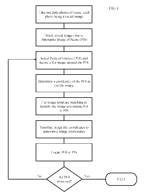
[0023] FIG 4 is a flowchart showing the process of visualising the
virtual
prisms;
[0024] FIG 5 is a flowchart showing the additional steps for overlaying
a
slope stability map on the panoramic image;
[0025] FIG 6 is a panoramic image of a scene to be monitored;
[0026] FIG 7 is an image tile;
[0027] FIG 8 depicts the location of the image tile in the panoramic
image;
[0028] FIG 9 shows a series of images depicting the operation of the
invention for accurately displaying points of interest; and
[0029] FIG 10 shows the panoramic image of FIG 9 with an overlaid
movement map.
DETAILED DESCRIPTION OF THE INVENTION
[0030] Embodiments of the present invention reside primarily in a method of
visualizing points of interest on a slope, building or tunnel, particularly an
open
CA 03078991 2020-04-13
WO 2019/104368
PCT/AU2018/000233
6
cut mine wall, corrected for photographic image distortion. Accordingly, the
method steps have been illustrated in concise schematic form in the drawings,
showing only those specific details that are necessary for understanding the
embodiments of the present invention, but so as not to obscure the disclosure
with excessive detail that will be readily apparent to those of ordinary skill
in the
art having the benefit of the present description.
[0031] In this
specification, adjectives such as first and second, left and right,
and the like may be used solely to distinguish one element or action from
another element or action without necessarily requiring or implying any actual
such relationship or order. Words such as "comprises" or "includes" are
intended to define a non-exclusive inclusion, such that a process, method,
article, or apparatus that comprises a list of elements does not include only
those
elements but may include other elements not expressly listed, including
elements that are inherent to such a process, method, article, or apparatus.
[0032] Referring to FIG 1 there is a shown a photograph of a typical pit with
a
number of walls or slopes, any of which may present a risk of failure leading
to
loss of equipment and possibly injury. Overlaid on the photograph is an array
of
desirable prism locations, such as 10, for effective monitoring of the slope.
Persons skilled in the art will understand that it is not economically
feasible to
deploy a large number of real prisms. It will also be appreciated that it
would not
be safe to locate prisms in certain parts of the slope that may be unstable,
although these are exactly the parts that need to be monitored.
[0033] FIG 2 shows the same open cut mine with the location of real prisms
indicated by diamonds. The real prisms are reflectors that return a signal to
a
monitoring device. By way of example, if an optical monitoring device is used,
such as a laser, the real prisms will be retroreflectors. A person skilled in
the art
will easily determine the nature of real prism required for the monitoring
device.
[0034] The number of real prisms is less than desirable and they are not
located in the ideal positions. Prisms may be lost or rendered useless by
various
factors including rock fall, dust build up, condensation or water build up
inside
the prism. The problem of not having enough prisms in the most suitable
CA 03078991 2020-04-13
WO 2019/104368 PCT/AU2018/000233
7
locations is addressed by providing virtual prisms, as shown by crosses 11 in
FIG 3. A virtual prism is a reflectorless measurement taken directly from the
rock
or other surface. It could be measured, for example, by using Slope Stability
Lidar described in co-pending international publication number W02017/063033.
[0035] To be useful the exact location of the virtual prisms must be known and
therefore any image distortion will lead to inaccuracy. This is particularly a
problem in wide angle images that are distorted by imaging optics. An
alternate
image is a panoramic image stitched together from narrower field of view
images, but these too have distortions leading to incorrect determination of
the
coordinates of the virtual prisms. The difficulty lies in visualizing the
known points
of interest. A laser scanner or robotic total station registers the location
of the
points by measuring the angular offset and distance from the scanner. Due to
photographic distortion the photographic image is not aligned to the scanner's
coordinate system. The technique described below with reference to FIG 4
obtains an accurate location for each prism on the photograph regardless of
photographic image distortion. The technique applies to virtual prisms and
real
prisms since although the visual location of a real prism may appear accurate
in
the panoramic image it may not align with the scanner coordinate system.
Similarly, the virtual prisms will be accurate in the coordinate system of the
scanner but will not appear accurately in the panoramic image.
[0036] The flowchart of FIG 4 sets out the steps for visualization of virtual
prisms for monitoring slope stability. A number of photographs are taken of a
scene covering the slope(s) to be monitored. The photographs have a limited
field of view, say 33 degrees on the diagonal. Other suitable sizes may be as
high a zoom as 1 degree or between 5 degrees and 45 degrees, including 10
degrees, 15 degrees, 20 degrees, 25 degrees, 30 degrees, 35 degrees, 40
degrees, or any number in between. Each photograph is taken from the same
location.
[0037] Each photograph constitutes a visual image and the visual images are
stitched together to form a panoramic image of the scene (PIS). Locations
within
the panoramic image are described by a panoramic image coordinate system,
which may simply be a pixel location (eg. within a 1024 x 768 pixel display) .
CA 03078991 2020-04-13
WO 2019/104368
PCT/AU2018/000233
8
Locations within the visual images that are used to form the panoramic image
will be defined according to a visual image coordinate system which will be
different from the panoramic image coordinate system. The visual image
coordinate system may be any coordinate system that is available, such as a
geodesic coordinate system or mine coordinate system. The specific coordinate
system is not important except that the location of each visual image is
specified
according to the same coordinate system. A geodesic coordinate system may be
a map system using degrees, minutes and seconds. A mine coordinate system
may be a polar coordinate system using as a reference point a known location
in
the mine.
[0038] Each image tile has lens and sensor distortion, plus the process of
stitching the visual images into the PIS necessarily causes distortion of the
visual
images in order to achieve a continuous appearing image from the contiguous
visual images. As a result of the process the location of any particular point
in
the panoramic image may not be accurate according to the visual image
coordinate system, although there will be a non-linear mapping from the visual
image coordinate system to the panoramic image coordinate system.
Unfortunately, the mapping is complex and the processing required to calculate
the mapping is too time consuming to be practical. Some other technique for
determining the real position of a Point of Interest in the PIS is needed.
[0039] Referring again to FIG 4, a Point of Interest is selected in the
panoramic image. This may be a readily identifiable feature or it may simply
be a
desirable position to construct an array of virtual prisms. Once a POI is
selected
an image tile that contains the POI is identified or recorded. Preferably the
image
tile is a photographic image of the area around the selected POI recorded at a
suitable zoom level, which may be a greater zoom level than the visual images
used to construct the panoramic image. However, it is also acceptable to
select
the original visual image that was used to construct the panoramic image. If a
new image is recorded it must contain the centre of a tile in the panoramic
image. The image tile must be recorded from the same location as the visual
images, which will obviously be the case if the image tile is one of the
visual
images. Because the location of the camera is known the coordinate of the POI
CA 03078991 2020-04-13
WO 2019/104368 PCT/AU2018/000233
9
will be known according to the visual image coordinate system.
[0040] The coordinate of the centre of each panoramic image tile in the
panoramic image coordinate system is known by virtue of the location of the
camera being precisely known by surveying at the time of set up. From the
centre coordinate the coordinate of the POI can be determined. An Image
Template Matching process is used to find the POI image tile in the panoramic
image. A mapping is then calculated between the apparent centre coordinate of
the Panoramic image tile in the panoramic image and the coordinates recorded
for the POI image tile in the POI coordinate system. The mapping is then used
to
correct the coordinate of the POI so that the POI is correctly located on the
PIS.
[0041] The process may be repeated a number of times as required for the
number of points of interest. Not every Point of Interest needs to be
determined
by this process since it will be acceptable to interpolate between POI,
depending
on the desired precision.
[0042] Once all the POI are determined and mapped to an accurate
coordinate the POI can be used for further processing. Accurate visualization
of
the POI is important for understanding slope behavior.
[0043] Those skilled in the art will realise that there are many image
template
matching (ITM) algorithms and methods available to align two photos of various
image sizes to suitably co-register two images taken from the same location.
The
inventors have found that a suitable algorithm uses edge detection being sharp
changes in contrast, brightness, or saturation to identify sharp boundaries,
patterns and features in each image then scale, rotate and slightly distort
images
to align the frames so that the identified boundaries match to within an
acceptable margin, before applying several blending algorithms to smooth the
exposures, hue, saturation, brightness and contrast channels between images to
get a more consistent panoramic image.
[0044] The process outlined in the flowchart of FIG 4 is used to improve slope
stability visualization as depicted in the flowchart of FIG 5. A slope
stability map
(SSM) may be recorded using a number of the available slope monitoring
techniques, such as those described in the Applicant's International Patent
CA 03078991 2020-04-13
WO 2019/104368
PCT/AU2018/000233
Application numbers W02002/046790 (Slope Monitoring System) and
W02017/063033 (Slope Stability Lidar), the contents of which are incorporated
herein by reference. The SSM is produced in the visual image coordinate system
and corrected to the PIS coordinate system, thereby allowing overlay of the
SSM
on the PIS. To maximize the accuracy of the visualization a POI in the SSM,
such as a location prone to significant movement, may be identified and a
nearby POI, such as virtual prism, is located in the PIS. The number of
selected
POI may be chosen as required to achieve the desired level of accuracy. As a
general comment, the more POI the greater the accuracy. There is no need to
have the same number of POI in the SSM and the PIS. It is likely that multiple
POI may be used around each region of interest in the SSM.
[0045] In order to further explain the operation of the invention a
panoramic
image of a scene is shown in FIG 6. The panoramic image is produced by
stitching together multiple visual images, all recorded from one location. The
individual images are not shown in FIG 6 but by way of indication the
panoramic
image of FIG 6 is produced from 56 visual images.
[0046] FIG 7 shows an image tile that contains a particular point of
interest,
being the rock face in the photograph. The image tile of FIG 7 is taken at a
greater optical zoom level than the original visual images. The cross through
the
image depicts the centre of the image which has a known coordinate by virtue
of
the known location of the camera taking the photograph and recording of the
azimuth and elevation at which the photograph is recorded.
[0047] FIG 8 depicts how image template matching is used to identify the
image tile in the panoramic image of the scene. The location 81 of the zoomed
image 80 in the panoramic image 82 is shown.
[0048] By way of further explanation, reference is made to the sequence of
images of FIG 9. FIG 9a shows a regular array of dots which may represent
virtual prisms to be applied to a panoramic image of a scene. As shown in FIG
9b, simply overlaying the regular grid on the image produces inaccuracies in
ground location because the 2D panoramic image contains distortions as
explained above. Using the technique of FIG 4 results in the array of dots
being
CA 03078991 2020-04-13
WO 2019/104368
PCT/AU2018/000233
11
moved to match the real POI as shown in FIG 9c. The result is that the regular
array of dots of FIG 9a is corrected to accurately represent their location in
the
PIS coordinates, as shown in FIG 9d.
[0049] As explained by reference to FIG 5, the technique allows for an
accurate overlay of a slope stability map on the panoramic image. This is
exemplified in FIG 10 where a slope stability heat map 100 is overlaid on the
panoramic image of FIG 9. In practice the slope stability heat map is in
colour,
grading towards red to indicate greater movement. Because the virtual prisms
are accurately located in the coordinate system of the panoramic image, and
the
slope stability map is accurately depicted in the same coordinate system, a
user
can clearly identify where on the ground movement is occurring and make
appropriate decisions. The movement may also be depicted by colour coding of
the prisms.
[0050] The above description of various embodiments of the present invention
is provided for purposes of description to one of ordinary skill in the
related art. It
is not intended to be exhaustive or to limit the invention to a single
disclosed
embodiment. As mentioned above, numerous alternatives and variations to the
present invention will be apparent to those skilled in the art of the above
teaching. Accordingly, while some alternative embodiments have been
discussed specifically, other embodiments will be apparent or relatively
easily
developed by those of ordinary skill in the art. Accordingly, this invention
is
intended to embrace all alternatives, modifications and variations of the
present
invention that have been discussed herein, and other embodiments that fall
within the spirit and scope of the above described invention.