Note: Descriptions are shown in the official language in which they were submitted.
ENHANCED LORAN SYSTEM GENERATING CORRECTION FACTORS BASED UPON
SATELLITE-DERIVED DATA AND RELATED METHODS
Field of the Invention
[0001] The present invention relates to the field of
navigation and, more particularly, to the enhanced Long Range
Navigation (eLORAN) system and related methods.
Background of the Invention
[0002] The Long Range Navigation (LORAN) system was
developed in the United States during World War II.
Subsequent implementations provided for enhancements in
accuracy and usefulness, including LORAN-C and later enhanced
LORAN (eLORAN) implementations. The eLORAN system is a low
frequency radio navigation system that operates in the
frequency band of 90 to 110 kHz and includes transmissions
that propagate by ground wave. The eLORAN system transmits
LORAN type navigation RF pulses at a center frequency of about
100 kHz and differs from LORAN-C in that eLORAN transmissions
are synchronized to the UTC similar to GPS, and include time-
of-transmission control, differential corrections similar to
differential GPS, the use of "all-in-view" tracking, and one
or more eLORAN data channels that provide low-rate data
messaging, differential corrections, and almanac information.
[0003] With the rise of satellite-based navigation systems
such as Global Positioning System (GPS), there has been
relatively little development or investment in terrestrial-
based navigation systems, such as the eLORAN system, until
recently. A renewed interest in such systems has arisen
regarding eLORAN as a backup to satellite based navigation and
timing systems, particularly since low frequency eLORAN
signals are less susceptible to jamming or spoofing compared
to the relatively higher frequency and lower powered GPS
signals.
1
Date Recue/Date Received 2020-04-22
[0004] In current eLORAN systems, each eLORAN receiver is
pre-loaded with a set of fixed, additional secondary factor
(ASF) maps. The ASF map values are measured correction
factors for the theoretical time-of-flight of the transmitted
pulses for the path from transmitter to receiver. These
correction factors are due to humidity, soil conductivity, and
other environmental conditions. There is usually one unique
ASF map per eLORAN transmitter. The values in these fixed ASF
maps are interpolated and extrapolated at an eLORAN receiver
from one-time ASF measurements that were acquired using a
single moving ASF mapping receiver in a coarse grid across a
coverage area of interest. For example, an ASF mapping
vehicle could travel at high speed along selected roads making
a single pass, and thus, acquire the values for implementing
the ASF Map, which are stored in each eLORAN receiver.
Reference stations that are located in populated areas or
major ports that require more accurate eLORAN positioning may
measure and distribute time-varying "local" ASF corrections
that are valid in about 35 kilometer radius coverage circles
from a reference station. These "local" ASF corrections are
transmitted in near real-time via the eLORAN data channel
(LDC).
[0005] There is a need for further developments in the
eLORAN system to improve eLORAN system performance in certain
applications.
Summary
[0006] An enhanced Long Range Navigation (eLORAN) system
may include an eLORAN controller configured to obtain
satellite-derived conductivity data and satellite-derived
temperature data for different geographical positions and
generate eLORAN correction factors based thereon. The eLORAN
system may also include a plurality of eLORAN transmitter
2
Date Recue/Date Received 2020-04-22
stations and at least one eLORAN receiver device. The at
least one eLORAN device may include an eLORAN receive antenna,
and an eLORAN receiver coupled to the eLORAN receive antenna
and configured to receive the eLORAN correction factors. The
eLORAN receiver device may also include a controller coupled
to the eLORAN receiver and configured to cooperate with the
plurality of eLORAN transmitter stations to determine an
eLORAN receiver position corrected based upon the eLORAN
correction factors.
[0007] The controller may be configured to cooperate with
the plurality of eLORAN transmitter stations to determine an
eLORAN receiver clock error corrected based upon the eLORAN
correction factors, for example. The satellite-derived
conductivity data may be based upon satellite-derived soil
moisture data. The satellite-derived conductivity data may be
based upon satellite-derived ocean surface data, for example.
[0008] The satellite-derived conductivity data may be based
upon satellite-derived rainfall rate data. The satellite-
derived conductivity data may be based upon at least one of
satellite-derived snow coverage data and satellite-derived ice
coverage data, for example.
[0009] The eLORAN controller may be configured to obtain
baseline conductivity data for the different geographical
positions, and generate the eLORAN correction factors based
upon the baseline conductivity data, for example. The eLORAN
controller may be configured to generate the eLORAN correction
factors at different times.
[0010] Each eLORAN transmitter station may include an
eLORAN transmit antenna, and an eLORAN transmitter coupled to
the eLORAN transmit antenna. The eLORAN transmitter may be
configured to transmit a series of eLORAN navigation RF
pulses.
[0011] A method aspect is directed to a method for enhanced
Long Range Navigation (eLORAN) position determining using an
3
Date Recue/Date Received 2020-04-22
eLORAN receiver device that includes an eLORAN receive
antenna, an eLORAN receiver coupled to the eLORAN receive
antenna, and a controller coupled to the eLORAN receiver. The
method may include using an eLORAN controller to obtain
satellite-derived conductivity data and satellite-derived
temperature data for different geographical positions and to
generate eLORAN correction factors based thereon. The method
may also include using a plurality of eLORAN transmitter
stations to cooperate with the eLORAN receiver so that the
controller of the eLORAN receiver device determines an eLORAN
receiver position and receiver clock error corrected based
upon the eLORAN correction factors.
Brief Description of the Drawings
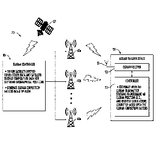
[0012] FIG. 1 is a schematic diagram of an eLORAN system
according to an embodiment.
[0013] FIG. 2 is a schematic block diagram of the eLORAN
system of FIG. 1.
[0014] FIG. 3 is a flow diagram of an eLORAN method in
accordance with an embodiment.
Detailed Description
[0015] The present invention will now be described more
fully hereinafter with reference to the accompanying drawings,
in which preferred embodiments of the invention are shown.
This invention may, however, be embodied in many different
forms and should not be construed as limited to the
embodiments set forth herein. Rather, these embodiments are
provided so that this disclosure will be thorough and
complete, and will fully convey the scope of the invention to
those skilled in the art. Like numbers refer to like elements
throughout.
[0016] Referring initially to FIGS. 1 and 2, an enhanced
Long Range Navigation (eLORAN) system 20 includes an eLORAN
4
Date Recue/Date Received 2020-04-22
controller 30 configured to obtain satellite-derived
conductivity data 21 and satellite-derived temperature data 22
for different geographical positions. By satellite-derived it
should be appreciated by those skilled in the art that the
source of the data is from one or more satellites 27 as will
be described in further detail below. It should also be
understood by those skilled in the art that the satellite-
derived conductivity data 21 and satellite-derived temperature
data 22 may be processed and/or formatted by the eLORAN
controller 30 and/or another processor or controller. In
other words, the eLORAN controller 30 may receive raw data
from the satellites 27.
[0017] In some embodiments, the eLORAN controller 30 may
obtain raw data from the satellites 27. The satellite-derived
conductivity data 21 may be based upon satellite-derived soil
moisture data. The satellite-derived conductivity data 21 may
be based upon satellite-derived ocean surface conductivity
data. The satellite-derived conductivity data 21 may be based
upon satellite-derived rainfall rate data. The satellite-
derived conductivity data 21 may be based upon one or more of
satellite-derived snow coverage data and satellite-derived ice
coverage data, for example.
[0018] The eLORAN controller 30 generates eLORAN correction
factors based upon the satellite-derived conductivity data 21
and the satellite-derived temperature data 22. The eLORAN
controller 30 may generate the eLORAN correction factors at
different times, for example, seasonally and/or periodically
(e.g., daily, weekly, monthly, quarterly, etc.)
[0019] In some embodiments, the eLORAN controller 30 may
obtain baseline conductivity data 23 for the different
geographical positions. More particularly, the eLORAN
controller 30 may obtain detailed ground conductivity and
permittivity values with known soil moisture content levels
from one or more different databases (e.g., national
Date Recue/Date Received 2020-04-22
databases), which may be used as the baseline conductivity
data 23.
[0020] The eLORAN system 20 also includes eLORAN
transmitter stations 40a-40n. Each eLORAN transmitter station
40a-40n includes an eLORAN transmit antenna 41a and eLORAN
transmitter 42a coupled to the eLORAN transmit antenna. Each
eLORAN transmitter station 40a-40n may transmit the eLORAN
correction factors. In some embodiments, the eLORAN
correction factors may be communicated by other techniques,
for example, a back channel. Each eLORAN transmitter 42a also
transmits a series of eLORAN navigation RF pulses.
[0021] The eLORAN system 20 also includes an eLORAN
receiver 50 device. The eLORAN receiver device 50 includes an
eLORAN receive antenna 51, and an eLORAN receiver 52 coupled
to the eLORAN receive antenna to receive the eLORAN correction
factors 28. The eLORAN receiver device 50 also includes a
controller 53 coupled to the eLORAN receiver 52 that
cooperates with the eLORAN transmitter stations 40a-40n to
determine an eLORAN receiver position and receiver clock error
corrected based upon the eLORAN correction factors 28.
[0022] Referring now additionally to the flowchart 60 in
FIG. 3, beginning at Block 62, further details of determining
position using the eLORAN system 20 will now be described. As
will be described below, the eLORAN system 20 described herein
uses a combination of existing terrestrial instruments,
existing satellite scientific instruments and available
databases, and modified existing low frequency (LF) ground
wave propagation modeling tools to determine propagation
delays of LF ground waves as they are impacted by
conductivity, permittivity, salinity and temperature.
Propagation delay tables or maps may be created.
[0023] The eLORAN controller 30 acquires relatively
detailed ground conductivity and permittivity values with
known soil moisture content levels from one or more databases,
6
Date Recue/Date Received 2020-04-22
for example, national databases, and uses these values as a
baseline (Block 64). More particularly, the databases may be
used to generate a detailed grid of soil conductivity at known
content levels as a baseline. The databases may also be used
to generate a grid of ocean surface conductivity at known
content levels also as a baseline. At Block 66, the eLORAN
controller 30 acquires relatively coarse, e.g., in real-time
or near-real-time, ground conductivity, temperature, and soil
moisture measurements, for example, from a network such as a
national network, for correlation of satellite instrument
data. It should be noted that the Geostationary Operational
Environmental Satellite (GOES) system already correlates data.
[0024] The eLORAN controller 30 acquires relatively
detailed, e.g., in near-real-time, geolocated rainfall rate,
soil moisture content, and earth surface temperature data
(e.g., soil and/or sea water temperatures) from satellite
instrument data, such as the GOES system, Himawari, and/or the
Joint Polar Satellite System (JPSS) (Block 68). Of course,
other satellites or satellite instrument data may be used.
[0025] At Block 70, the eLORAN controller 30 acquires
relatively detailed, e.g., in near-real-time, geolocated snow
and ice coverage data from the satellite instrument data.
Those skilled in the art will appreciate that terrestrial
instruments may be used to calibrate the satellites or
satellite instrument data.
[0026] Soil moisture data and temperature data are applied
to the baseline data to arrive at updated
conductivity/resistivity and permittivity values (Block 72).
The models or modeling tools implemented by the eLORAN
controller 30 may be modified to accept higher density, more
accurate and detailed conductivity and dielectric values, as
will be appreciated by those skilled in the art.
[0027] At Block 74, the eLORAN controller 30 applies snow
coverage and ice coverage LF radio frequency (RF) groundwave
7
Date Recue/Date Received 2020-04-22
propagation effects. At Block 76, relatively detailed ocean
surface values are acquired (e.g., in near real time) from the
satellite instrument data (e.g., salinity). The eLORAN
controller 30 may also acquire detailed ocean water salinity
data from the terrestrial instruments to calibrate the
satellite instrument data for the ocean water temperatures
and/or ocean surface conductivity values.
[0028] Ocean surface conductivity values are applied (Block
78) by the eLORAN controller 30. The eLORAN controller 30 may
implement models or modeling tools that may be modified to
accept the varying ocean surface conductivity values.
[0029] The eLORAN controller 30 at Block 80, creates or
generates a table and/or map of LF RF groundwave propagation
characteristics. The tables and/or maps may be generated with
updated propagation delay values which can be used to
determine the time-of-arrival of an LF signal with greater
accuracy than previous approaches. Moreover, these tables or
maps can be provided to LF navigation and time system
receivers/users to increase the accuracy of a time or position
determination (e.g., to correct errors in position and clock
error). Operations end at Block 82.
[0030] Indeed, as will be appreciated by those skilled in
the art, most propagation models only produce results that are
only as accurate as the databases used for the calculations.
Increased precision surface impedance and terrain measurements
may thus be highly desirable, but oftentimes, this data is not
available. For example, the U.S. conductivity database
includes only 16 levels. Additionally, conductivity databases
often have limited resolution. Therefore, the accuracy of the
conductivity database is limited unless every point is
measured, for example.
[0031] Those skilled in the art will appreciate that
changes in impedance may be seasonal due to weather changes.
8
Date Recue/Date Received 2020-04-22
The resulting conductivity changes limit the accuracy of the
modeled additional secondary factors (ASFs).
[0032] Currently, low frequency eLORAN signal propagation
characteristics over land are either measured and recorded or
modeled using relatively very low precision soil conductivity
charts. Over sea, a single conductivity value is typically
used.
[0033] Measuring of conductivity may be accomplished by the
use of vehicles or naval vessels. Attempts at using aviation
platforms may be undesirable as those techniques may not
provide the desired accuracy. Nonetheless, the above-methods
of measuring conductivity are all relatively costly and time
consuming, particularly when it is desirable to characterize a
large area, e.g., the continental United States.
[0034] While models may be used to predict conductivity,
these models are dependent on old or outdated soil
conductivity maps and databases that do not have adequate
resolution, and were provided for frequencies outside the 100
kHz eLORAN spectrum. A single conductivity value is typically
used for propagation over sea.
[0035] Soil Conductivity varies with changes in moisture
content, temperature, and the presence of ice and snow. Also,
sea surface conductivity changes with salinity and
temperature.
[0036] In particular, for eLORAN propagation modelling, the
following equation is typically used:
True Propagation Time = PF + SF + ASF
where PF = 2.99691162e8 m/s (propagation time for the signal
to traverse the atmosphere), SF (secondary factor) = delays
for signal over salt seawater with a conductivity of 5000 mS/m
(assumes the entire signal path is over sea water and that
dielectric and conductivity properties are constant), and ASF
(additional secondary factor) = incremental propagation delay
of the signal over heterogeneous earth (vs. seawater).
9
Date Recue/Date Received 2020-04-22
[0037] With respect to ASF data, one relatively key
parameter is impedance (conductivity) of the surface. ASF
data is generally considered a function of distance, surface
impedance (conductivity), topography, surface temperature, and
moisture content. Variations of weather, time of day (sun),
and other environmental changes throughout the day may
influence ASF data.
[0038] With respect to LF ground wave propagation,
influential factors may include the spherical shape of the
Earth and spatial variations, for example, coastlines,
topography, and ground impedance. Factors influencing the
ground impedance may include ground conductivity (e.g., soil
moisture), dielectric constant, and vertical geological ground
structure, for example. Another factors that may affect LF
ground wave propagation may include variations, such as, for
example, surface impedance change due to weather, the
influence to the index of refraction of air at the surface of
the ground due to weather, and variations of the gradient of
the index of refraction (at surface of ground with altitude
above the surface).
[0039] As will be appreciated by those skilled in the art,
the eLORAN system 20 described herein addresses the
shortcomings noted above and with consideration of and
correction for the various factors described above. By using
a combination of existing terrestrial instruments, existing
satellite scientific instruments and available databases, and
modified existing Low Frequency (LF) ground wave propagation
modeling tools, propagation delays of low frequency (LF)
ground waves as they are impacted by conductivity,
permittivity, salinity and temperature may be determined by
the eLORAN system 20 and propagation delay tables or maps may
be created for correction of errors, for example, that may be
created through propagation errors and delays, as described
above. Accordingly, the eLORAN system 20 may provide improved
Date Recue/Date Received 2020-04-22
accuracy with respect to errors of eLORAN receiver position
and clock error.
[0040] A method aspect is directed to a method for enhanced
Long Range Navigation (eLORAN) position determining using an
eLORAN receiver device 50 that includes an eLORAN receive
antenna 51, an eLORAN receiver 52 coupled to the eLORAN
receive antenna, and a controller 53 coupled to the eLORAN
receiver. The method includes using an eLORAN controller 30
to obtain satellite-derived conductivity data 21 and
satellite-derived temperature data 22 for different
geographical positions and to generate eLORAN correction
factors 28 based thereon. The method also includes using a
plurality of eLORAN transmitter stations 40a-40n to transmit
the eLORAN correction factors 28 and cooperate with the eLORAN
receiver 52 so that the controller 53 of the eLORAN receiver
device determines an eLORAN receiver position and receiver
clock error corrected based upon the eLORAN correction
factors.
[0041] Many modifications and other embodiments of the
invention will come to the mind of one skilled in the art
having the benefit of the teachings presented in the foregoing
descriptions and the associated drawings. Therefore, it is
understood that the invention is not to be limited to the
specific embodiments disclosed, and that modifications and
embodiments are intended to be included within the scope of
the appended claims.
11
Date Recue/Date Received 2020-04-22