Note: Descriptions are shown in the official language in which they were submitted.
CA 03084277 2020-05-07
WO 2019/119041 PCT/AU2018/051362
1
TITLE
PRODUCTION OF SLOPE DEFORMATION MAPS
FIELD OF THE INVENTION
[001] The present invention relates to the field of industrial safety and
in
particular mine safety. More particularly, the invention relates to a method
and
apparatus for monitoring slope deformation in open cut and underground mining
applications.
BACKGROUND TO THE INVENTION
[002] The Applicant has previously described a Slope Monitoring System
based on using interferometric radar measurements of an observed slope. The
technique is well described in International Patent Application number
PCT/AU2001/01570. In one important application the Slope Stability Radar
(SSR) described in PCT/AU2001/001570 is used to monitor rock walls in an
open cut mine to detect any dangerous movement that may lead to slope failure.
[003] More recently the Applicant has described a slope monitoring device
based on Slope Stability LiDAR (SSL). International Patent Application number
PCT/AU2016/050953 describes a laser-based device that is used in a similar
manner to the SSR to monitor slope movement in open cut and underground
mines.
[004] A Slope Stability Radar or Slope Stability LiDAR fundamentally
measures the amount of movement between measurements in a voxel (pixel for
2D radar) on a slope and the range to the voxel. Thus a deformation map is
produced that shows voxel by voxel movement of a slope over time from which
alerts are generated to warn of impending slope failure.
[005] To achieve maximum safety benefit both the SSR and SSL devices
require accurate and reliable measurements. In International Patent
Application
number PCT/AU2006/001013, the Applicant explained that various disturbances
could impact on the accuracy and reliability of the SSR measurements (which
CA 03084277 2020-05-07
WO 2019/119041 PCT/AU2018/051362
2
will also be the case for SSL). In particular, the disturbances could be
classified
as short term (such as a truck passing through the field of view) and long
term
(such as vegetation). The application describes a technique of detecting
variation in short-term and long-term coherence values as an indicator of the
need for error correction in the movement data. The content of International
Patent Application number PCT/AU2006/001013 is incorporated herein by
reference.
[006] International Patent Application number PCT/AU2006/001013 also
describes a method of correcting for changes in atmospheric conditions. The
method relies upon identifying an atmospheric correction region and applying
bulk correction based on changes in the atmospheric correction region. The
Applicant has found that existing techniques for bulk correction, such as
handling
changes in atmospheric conditions, could be improved. In fact, the Applicant
is
aware that some known atmospheric correction techniques have difficulty
capturing both small fast moving deformations and large slow moving
deformations. Existing techniques are set up to capture one or the other and
it is
generally true that automatic atmospheric correction techniques can result in
the
masking or suppressing of some wall movements. This is particularly so for
atmospheric effects caused by snow, which existing techniques are unable to
handle.
SUMMARY OF THE INVENTION
[007] In one form, although it need not be the only or indeed the broadest
form, the invention resides in a slope stability monitoring apparatus
comprising:
a Radar or Lidar that records movement data of an observed slope or wall;
a processor that:
corrects the movement data for apparent movement that is not wall or
slope related;
processes the corrected movement data to produce deformation
maps indicative of movement of the observed slope or wall over time;
generates alarms indicating wall or slope movement above a
CA 03084277 2020-05-07
WO 2019/119041
PCT/AU2018/051362
3
threshold; and
a display that displays the deformation maps and alarms.
[008] Preferably the movement data is processed interferometrically and the
deformation maps are interferometric deformation maps.
[009] In a further form the invention resides in a method of producing a
deformation map of a monitored area including the steps of:
recording UnCorrected Deformation data (UCD) of movement data in the
monitored area;
spatially averaging the UnCorrected Deformation data (UCD) to produce
Background Deformation data (BD) with minimal effect from small area
movement;
temporally averaging the Background Deformation data (BD) to produce
Background Deformation averaged data (BDa) with primary effect from slow
moving large areas;
subtracting the Background Deformation data (BD) from the UnCorrected
Deformation data (UCD) to produce Background Subtracted Deformation data
(BSD) with minimal effect from large area movement;
deriving a correction factor from the Background Deformation averaged data
(BDa);
applying the correction factor to produce Corrected Background Deformation
averaged data (CBDa);
using the Corrected Background Deformation averaged data (CBDa) with the
Background Subtracted Deformation data (BSD) to produce Multiscale
Deformation data (MSD); and
producing a deformation map from the Multiscale Deformation data (MSD) which
shows movement in the monitored area.
[0010] Preferably the deformation map is an interferometric deformation map
produced from interferometric movement data.
[0011] The method may further include temporally averaging the Background
Subtracted Deformation data (BSD) to produce Background Subtracted
Deformation averaged data (BSDa) with primary effect from slow moving small
CA 03084277 2020-05-07
WO 2019/119041
PCT/AU2018/051362
4
areas; and deriving the correction factor from the Background Deformation
averaged data (BDa) and the Background Subtracted Deformation averaged
data (BSDa).
[0012] The step of deriving the correction factor may include applying a
mask
to remove outlier data from the Background Deformation averaged data (BiDa)
and/or Background Subtracted Deformation averaged (BSDa) data.
[0013] In a further form the method may be recursive with multiple steps of
spatial averaging with each spatial average averaging over a different area,
and
multiple steps of temporal averaging with each temporal average occurring over
a different time period.
[0014] In a yet further form the invention resides in a method of producing
a
deformation map of a monitored area by spatially averaging over at least two
different areas and temporally averaging over at least two different times
including the steps of:
recording UnCorrected Deformation data (UCD) of movement data in the
monitored area;
spatially averaging the UnCorrected Deformation data (UCD) to produce
Background Deformation data (BDx) on a first scale x;
temporally averaging the Background Deformation data (BDx) to produce
Background Deformation averaged data (BDax) on the first scale x;
subtracting the Background Deformation data (BDx) from the UnCorrected
Deformation data (UCD) to produce Background Subtracted Deformation data
(BSDx) on the first scale x;
spatially averaging the Background Deformation averaged data (BDax) to
produce a Background Deformation data (BDy) on a second scale y;
temporally averaging the Background Deformation data (BDy) on the second
scale y to produce Background Deformation averaged data (BDay) on the
second scale y;
subtracting the Background Deformation data (BDy) on the second scale y from
the Background Deformation averaged data (BDax) on the first scale x to
produce Background Subtracted Deformation data (BSDy) on the second scale
CA 03084277 2020-05-07
WO 2019/119041
PCT/AU2018/051362
y;
deriving a correction factor from the Background Deformation averaged data
(BDay) on the second scale y;
applying the correction factor to produce Corrected Background Deformation
averaged data (CBDa); and
using the Corrected Background Deformation averaged data (CBDa) with the
Background Subtracted Deformation data (BSDx) on the first scale x and the
Background Subtracted Deformation data (BSDy) on the second scale y to
produce Multiscale Deformation data (MSD); and
producing a deformation map from the Multiscale Deformation data (MSD) which
shows movement in the monitored area.
[0015] The data processing is preferably interferometric and the
deformation
map is preferably an interferometric deformation map.
[0016] The method may be extended by:
spatially averaging the Background Deformation averaged data (BDay) on the
second scale y to produce Background interferometric Deformation data (BDz)
on a third scale z;
temporally averaging the Background Deformation data (BDz) on the third scale
z to produce Background Deformation averaged data (BDaz) on the third scale z;
subtracting the Background Deformation data (BDz) on the third scale z from
the
Background Deformation averaged data (BDay) on the second scale y to
produce Background Subtracted Deformation data (BSDz) on the third scale z;
deriving the correction factor from the Background Deformation averaged data
(BDaz) on the third scale z; and
also using the Background Subtracted Deformation data (BSDz) on the third
scale z to produce the Multiscale interferometric Deformation data (MSD).
[0017] The step of spatially averaging may be by spatial selection. Spatial
selection may be by sub-sampling.
[0018] The step of temporal averaging is suitably by temporal step
averaging. The temporal step averaging may step across a range from every
CA 03084277 2020-05-07
WO 2019/119041 PCT/AU2018/051362
6
scan to 24 hours, or any time step in between including but not limited to a
minute, a few minutes, 1 hour, 2 hours, 6 hours 12 hours and 18 hours. There
may be a time gap between steps of a few minutes, 1 hour, 2 hours, 4 hours or
more, or any time in between.
[0019] Further features and advantages of the present invention will become
apparent from the following detailed description.
BRIEF DESCRIPTION OF THE DRAWINGS
[0020] To assist in understanding the invention and to enable a person
skilled in the art to put the invention into practical effect, preferred
embodiments
of the invention will be described by way of example only with reference to
the
accompanying drawings, in which:
[0021] FIG 1 is a sketch of a slope stability monitoring apparatus
producing improved deformation maps;
[0022] FIG 2 is a conceptual flow chart of a bulk correction of slow
deformation data and a spatial correction of fast deformation data
obtained from a Radar or Lidar;
[0023] FIG 3 shows a practical implementation of the concept of FIG 2;
[0024] FIG 4 shows uncorrected deformation data (UCD);
[0025] FIG 5a shows background (spatially averaged) deformation data (BD);
[0026] FIG 5b shows background subtracted deformation data (BSD);
[0027] FIG 6a shows temporally averaged background deformation data
(BDa);
[0028] FIG 6b shows temporally averaged background subtracted
deformation data (BSDa);
[0029] FIG 7 shows corrected background deformation averaged data
(CBDa);
[0030] FIG 8 shows a corrected deformation map (MSD);
[0031] FIG 9 shows a process for determining Bulk Correction Factor; and
[0032] FIG 10 shows a four-scale process.
CA 03084277 2020-05-07
WO 2019/119041 PCT/AU2018/051362
7
DETAILED DESCRIPTION OF THE INVENTION
[0033] Embodiments of the present invention reside primarily in a method of
multiscale processing for atmospheric correction of slope monitoring
deformation
data. Accordingly, the method steps have been illustrated in concise schematic
form in the drawings, showing only those specific details that are necessary
for
understanding the embodiments of the present invention, but so as not to
obscure the disclosure with excessive detail that will be readily apparent to
those
of ordinary skill in the art having the benefit of the present description.
[0034] In this specification, adjectives such as first and second, left and
right,
and the like may be used solely to distinguish one element or action from
another element or action without necessarily requiring or implying any actual
such relationship or order. Words such as "comprises" or "includes" are
intended to define a non-exclusive inclusion, such that a process, method,
article, or apparatus that comprises a list of elements does not include only
those
elements but may include other elements not expressly listed, including
elements that are inherent to such a process, method, article, or apparatus.
[0035] Referring to FIG 1 there is shown a slope stability monitoring
apparatus 1. The slope stability monitoring apparatus may be Radar apparatus
or a Lidar apparatus. For ease of explanation the following explanation of an
embodiment relates to interferometric Radar. The invention could be applied to
other slope stability monitoring apparatuses including Radars and Lidars that
are
2D, 3D, airborne, spaceborne, ground-based, static, mobile, real aperture,
synthetic aperture, Doppler, time of flight or interferometric.
[0036] The apparatus 1 is directed at a slope 2, at least a part of which
may
be at risk of movement, such as the movement depicted by the arrows 3. The
apparatus 1 comprises a radar dish 4 that is moved to scan a signal across the
slope. The reflected radar signal is analysed for phase difference from which
movement data is derived. The process is known as interferometric signal
processing and is described in PCT/AU2001/001570.
CA 03084277 2020-05-07
WO 2019/119041 PCT/AU2018/051362
8
[0037] The interferometric signal processing is performed in a processor
which may be conveniently located on the apparatus in a box 5 together with a
power supply and other equipment for operation of the radar. The result of the
interferometric signal processing is rendered as a movement map which shows
which part of the wall is moving and in what direction. The processor may also
generate alarms to give warning of significant movement that may lead to slope
failure.
[0038] One problem with the apparatus of FIG 1 is that there may be
apparent movement which is in fact due to non-wall influences. One such
influence is change in atmospheric conditions. The apparatus corrects the
interferometric signal processing to compensate for apparent movement that is
not-wall related.
[0039] By way of general explanation, the data from a radar may include
measurements of fast moving small areas (FSA), slow moving small areas
(SSA), slow moving large areas (SLA) and, rarely, fast moving large areas
(FLA). Subtracting a spatial average from the incoming data primarily
preserves
FSA and most SSA; while suppressing the effect of the short term spatial
character in the atmosphere. The spatial averaged stream will preserve FLA,
SLA and atmospheric effects. Temporal averaging the spatial averaged stream
preserves SLA and bulk atmospheric effects while suppressing short term
spatial
atmospheric events and FLA. The background subtracted stream can also be
temporally averaged and when it is added to the temporally averaged data a
dataset is produced from which the bulk correction can be easily calculated. A
correction factor is calculated and applied to the data to produce a stream in
which SLA is preserved and the bulk atmosphere suppressed. For simplicity this
can be added to the background subtracted stream so that a single data stream
contains SLA, FSA and SSA with little contamination from the atmosphere or
other effects such as instrument drift. The corrected data is then used to
produce improved deformation maps to provide early warning of impending
slope failure. FLA events are rare and only occur after a blast or a wall
failure
CA 03084277 2020-05-07
WO 2019/119041 PCT/AU2018/051362
9
which will increase the mines alertness so that the residual FLA signal due to
likely non¨uniformity and rapid movement will still be apparent.
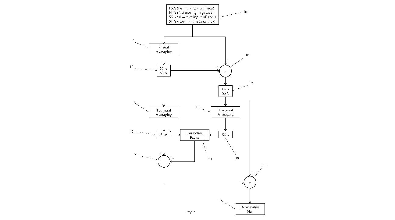
[0040] The process is summarised in FIG 2. The radar data 10 is spatially
averaged 11 to produce a dataset preserving FLA and SLA 12 which uses
temporal averaging 14 to obtain SLA data 15. The dataset 12 is subtracted 16
from the radar data 10 to produce a dataset containing FSA and SSA 17 which is
also temporally averaged 18 to obtain SSA 19. The SSA 19 and SLA 15 data is
used to calculate a correction factor 20 that corrects for bulk effects,
particularly
atmospheric changes and instrument drift. The correction factor 20 is
subtracted
21 from the SLA data 15. This corrected data is combined 22 with FSA and SSA
17 to provide a dataset from which improved deformation maps are produced
using the techniques described in the earlier patents mentioned previously,
the
content of which are incorporated herein by reference. These deformation maps
13 are greatly improved by having bulk effects, such as atmospheric drift and
instrument drift, suppressed.
[0041] One process for the determination of the correction factor 20 is
that
SSA and SLA data is added and the total is plotted against range from the
radar
to the voxel from which the data is recorded. The slope of a line of best fit
is the
bulk correction factor and the y-intercept accounts for drift errors in the
radar.
The process is described in detail by reference to the embodiments which
follow.
[0042] A practical implementation of the process of FIG 2 is shown in FIG 3
with example data provided in the following figures. The data is taken from a
GroundProbe SSR-FX radar. The SSR-FX monitors a thin vertical stripe on the
wall that is rotated left-to-right like a fan and does not move up-and-down
like a
spotlight. The SSR-FX can scan 180 degrees in less than two minutes and
processed data is immediately available. It is a real aperture radar which
gives
broad area coverage, using a pixel resolution of over 1.4 million pixels per
scan,
updated at least every two minutes, with a maximum diameter of 5.6km. To
indicate that this specific embodiment is applied to interferometric data the
data
labels are amended to include the interferometric reference. Thus UnCorrected
CA 03084277 2020-05-07
WO 2019/119041 PCT/AU2018/051362
Deformation (UCD) data becomes UnCorrected interferometric Deformation
(UCiD) data, on so forth.
[0043] The process described herein is not limited to interferometrically
obtained data sets. For instance, the data sets could be range data obtained
from a Lidar device rather than the phase data obtained from a Radar device. A
Lidar can also generate phase data which can be processed interferometrically.
[0044] Referring to FIG 3, a wall (or slope) is monitored using slope
stability
radar or slope stability Lidar and uncorrected interferometric deformation
(UCiD)
data is collected each scan. The uncorrected interferometric deformation
(UCiD)
data is a stream of phase data. Interferometric phase is the phase change for
any pixel between scans. Interferometric phase is converted to UCiD by
multiplying by X/47c. The data is referred to as "uncorrected" to make clear
that no
attempt has been made to make any bulk correction, whether for the atmosphere
or otherwise. However it does not mean that some degree of pre-processing
may not have occurred. Indeed, most Radar and Lidar equipment processes the
raw data stream. In addition, specific implementations may involve additional
proprietary pre-processing before application of the method described herein.
[0045] The uncorrected interferometric deformation (UCiD) data may be
processed in the manner described in the earlier patents mentioned above to
produce deformation maps, such as shown in the figures. Essentially the UCiD
data is summed to get uncorrected deformation (UCD). This is a single scale
process without temporal or spatial filtering and without bulk correction. UCD
shows the cumulative result of both real wall movements and bulk (such as
atmospheric) changes across the image time period. The process described in
detail below is a method of correcting for short-term spatial atmospheric
(like)
effects and longer-term bulk atmospheric (like) effects.
[0046] In the following figures the deformation maps show cumulative data
rather than a single scan. This is necessary so that wall movements that
emerge
over time can be visualized. For ease of explanation the detailed process is
described by reference to each scan, but the figures exemplifying the process
CA 03084277 2020-05-07
WO 2019/119041 PCT/AU2018/051362
11
are cumulative data over a period of approximately 3.5 days. For example, the
data in FIG 4 is actually uncorrected deformation (UCD) data not uncorrected
interferometric deformation (UCiD) data.
[0047] The UCiD data is spatially averaged by a process described in
greater
detail below by reference to FIG 5a to obtain background interferometric
deformation (BiD) data. The BiD data is then temporally averaged to produce
background interferometric deformation averaged (BiDa) data, a cumulated
sample of which is shown in FIG 6a.
[0048] There may also be an optional ambiguity handling process which
incorporates an ambiguity detector and spatial unwrapper. One approach for
ambiguity handling is described in International Publication number
W02007/009175 titled Interferometric Signal Processing.
[0049] The BiD data is subtracted from the uncorrected interferometric
deformation (UCiD) data to produce background subtracted interferometric
deformation (BSiD) data. A cumulated sample of BSiD data is shown in FIG 5b.
The BSiD data may be temporally averaged to produce background subtracted
interferometric deformation averaged (BSiDa) data, a cumulated sample of
which is shown in FIG 6b. Although the step of temporally averaging the BSiD
data is optional it will usually be performed because it has been found that
in
most cases the Bulk Correction Factor obtained from BiDa and BSiDa generates
a greater improvement than obtaining the Bulk Correction Factor from BiDa
alone.
[0050] The BiDa data and the BSiDa data are used to calculate a bulk
correction factor as described above. To assist with this step it is optional
to
apply a mask as described below.
[0051] The bulk correction factor is subtracted from the BiDa data to
obtain
corrected background interferometric deformation averaged (CBiDa) data. An
example of cumulated CBiDa data is shown in FIG 7.
CA 03084277 2020-05-07
WO 2019/119041 PCT/AU2018/051362
12
[0052] The CBiDa data is added to the BSiD data to produce multiscale
interferometric deformation (MSiD) data. An example of cumulated MSiD data is
shown in FIG 8. The MSiD data is processed according to one of the methods
described in the patent applications referenced in the background section
above
to produce improved deformation maps. By way of example, FIG 4 shows a
deformation map without correction and FIG 8 shows the same data after the
processing of FIG 3. The lower degree of atmospheric clutter in FIG 8 means
that a lower alarm threshold can be set without increasing the false alarm
rate.
Also, the alarm threshold configuration is simpler because a constant spatial
atmospheric clutter level is achieved across the wall surface image.
[0053] The first step, as shown in FIG 2, is to spatially average the
uncorrected interferometric deformation (UCiD) data. A cumulative sample of
UCiD data (UCD) is shown in FIG 4. Spatial averaging may occur over different
volumes depending on the requirement for the data being corrected. That is,
the
value for each voxel in the data set is calculated as the average of the
values of
all voxels in a spherical window to produce Background interferometric
Deformation (BiD), as shown in FIG 5a (as cumulated data). The inventors have
found that a suitable volume for many situations is a sphere with a diameter
of
200m or 400m or 800m. Other suitable volumes are a sphere with 150m
diameter or all data in a sphere with 5600m diameter. Although reference is
made to averaging a volume containing multiple data voxels, it will be
appreciated that for 2D radar the data will be in pixels and the spatial
averaging
will be over an area.
[0054] The spatial averaging process is a sliding process in the sense that
a
value for each voxel is obtained by averaging the voxels surrounding that
voxel
and then the process moves to the next voxel and repeats. The number of
voxels in the data set remains the same. The window is truncated by the data
edge.
[0055] FIG 5a shows the spatially averaged background interferometric
deformation (BiD) cumulated to produce background deformation (BD). It is
evident from a review of FIG 5a that the classically processed data shown in
FIG
CA 03084277 2020-05-07
WO 2019/119041 PCT/AU2018/051362
13
4 shows more deformation detail. The deformation map of FIG 5a will show
large, slow moving areas but small moving areas are suppressed by averaging
out. Comparing FIG 5a with FIG 4 shows that background deformation captures
the spatial character of atmosphere while ignoring the major components of
wall
movements.
[0056] Background interferometric Deformation (BiD) is subtracted from
uncorrected interferometric deformation (UCiD) to create Background Subtracted
interferometric Deformation (BSiD) (FIG 5b). As nearby voxels tend to
experience a similar atmosphere, BSiD has most atmospheric effects removed.
The deformation in small fast moving areas will come through well into BSiD.
See for example movement at Al in FIG 5b. Large slow moving areas such as at
A2 will be suppressed by the background subtraction and not come through as
well into BSiD. This is because the movement is slow and large and on the
order
of the spatial averaging window size. BSiD shows other small fast moving areas
which are sometimes located within larger, slower moving areas that may not be
clear in background subtracted deformation (BSD) or background deformation
(BD) until it has been temporal averaged and had a bulk correction applied, as
described below.
[0057] Another phase of the process is to conduct temporal averaging.
Temporal averaging is performed by acquiring data for a period of time and
sliding the averaging window forward in time after an initial period of data
is
acquired. The inventors have found that a suitable time window is 24 hours.
Other time windows may also be suitable in particular circumstances as
described below. Thus the time window may be only 1 hour or even shorter. FIG
6a shows the time averaged spatially averaged background interferometric data
(BiDa), shown as a cumulated example.
[0058] In the same way BiDa was created by time averaging BiD, BSiDa is
created by time averaging BSiD. FIG 6b shows the time averaged spatially
averaged background interferometric data (BiDa).
CA 03084277 2020-05-07
WO 2019/119041 PCT/AU2018/051362
14
[0059] A Bulk Correction Factor is determined from BiDa and BSiDa. A
preferred process is depicted in FIG 9. BiDa and BSiDa data points at each
range management are added and plotted against the range of the data point.
Effectively this is plotting only the slow movements against range. The slope
of
the line is the Bulk Correction Factor. If there is any offset all or some
components of it may be due to instrument effects.
[0060] In case there are some outlier points, as shown in FIG 9, these may
be excluded by an optional manual or automatic masking process, as depicted in
FIG 3. A Manual Exclusion Mask may be selected by a user utilising a graphical
user interface to exclude regions such as shown circled in FIG 9. In this
embodiment the identified data points are excluded from the determination of
the
Bulk Correction Factor. An alternate manual process is for a user to select a
Manual Inclusion Mask of areas of the wall that are likely to be stable. This
is a
similar process to the current or classic user process of selecting and
setting
stable reference areas (SRAs). Pixels within the Manual Inclusion Mask that
also
have good amplitude and good coherence and which have previously not moved
too much are deemed to be good. BiDa and BSiDa on those pixels is most likely
due to changes in the bulk refractive index of the atmosphere. An automatic
process may automatically select in an Automatic Inclusion Mask a section of
the
slope that has moved, say, less than 2mm in, say, 2 days.
[0061] Once the Bulk Correction Factor is determined it is subtracted from
the BiDa data to produce CBiDa data, as mentioned above. The BSiD data is
added to the CBiDa data to produce Multiscale interferometric data from which
deformation maps are constructed free from distortion caused by bulk factors
such as atmospheric and instrument drift. A corrected deformation map shown in
FIG 8.
[0062] A benefit of adding BSiD and CBiDa is that a clearer image is
produced. A similarly clear image may be obtained by adding BiDa and BSiDa.
[0063] An alternate to spatial averaging as described in the above
embodiment is spatial selection. Spatial averaging by spatial selection is
done by
CA 03084277 2020-05-07
WO 2019/119041 PCT/AU2018/051362
selecting stable reference areas and using these as an approximation to a
larger
area. The technique could also be referred to as spatial sub-sample averaging.
The technique of selecting stable reference areas is well known to users of
this
monitoring technology and is a manual method for obtaining one or more spatial
averages, in one or more locations within the selected scan area. Estimating a
single bulk spatial correction by combining all the stable reference area
estimates is the simplest spatial averaging approach, however using multiple
regions to create sub-sampled averages of the scan area obtain a better
spatial
estimate. Both spatial selection averaging methods can also be automated by
selecting areas that are statistically high quality measurements. An
alternative to
temporal averaging as described in the above embodiment is temporal step
averaging. In temporal step averaging a block of data is averaged and then the
process steps to a next block of data, as opposed to the sliding window
approach described earlier. The size of the block and the time between blocks
is
set to achieve a desired duty cycle to suit available processing power. The
averaging method applied to temporal step averaging could suitably be a mean,
median or mode or likewise could be a temporal sub-sampling that has
interferometric or difference processing applied.
[0064] The example described above uses a two scale process with a single
spatial averaging volume and a single time window. The invention may be
extended to a multiscale process with multiple different averaging volumes and
different time windows. Turning now to FIG 10, there is shown one such
alternate process of multiscale processing for bulk correction of deformation
maps. As with the method of FIG 2 the processing commences with uncorrected
interferometric deformation (UCiD) data collected from a wall or slope using a
slope stability radar or slope stability Lidar. The UCiD data is first
spatially
averaged over an area of, say, 150m diameter to produce background
interferometric data (BiD15o). This data is then temporally averaged for 1
hour to
produce BiDa150 data. The BiD150 data is subtracted from the uncorrected
interferometric deformation (UCiD) data to produce background subtracted
interferometric deformation (BSiD150) data. Each of these processes are as
described above.
CA 03084277 2020-05-07
WO 2019/119041 PCT/AU2018/051362
16
[0065] The process is repeated for different scales, for example areas with
diameters of, say, 400m and 800m and time scales of, say, 8 hours and 24
hours. The process depicted in FIG 10 uses areas with diameters of 150m,
400m and 800m for spatial averaging but other areas with diameters of 100m,
200m 300m, 500m, 600m, 700m or diameters in between or greater will also be
suitable in certain situations. The multiscale process of FIG 9 is also not
limited
to particular time scales for temporal averaging but times of 2 hours, 3
hours, 5
hours, 6 hours, 7 hours or times in between or greater will also be suitable
in
certain situations.
[0066] The method of producing deformation maps significantly reduces
atmospheric effects while preserving important movement data. It presents a
significant safety improvement over the known techniques.
[0067] The above description of various embodiments of the present
invention is provided for purposes of description to one of ordinary skill in
the
related art. It is not intended to be exhaustive or to limit the invention to
a single
disclosed embodiment. As mentioned above, numerous alternatives and
variations to the present invention will be apparent to those skilled in the
art of
the above teaching. Accordingly, while some alternative embodiments have
been discussed specifically, other embodiments will be apparent or relatively
easily developed by those of ordinary skill in the art. Accordingly, this
invention
is intended to embrace all alternatives, modifications and variations of the
present invention that have been discussed herein, and other embodiments that
fall within the spirit and scope of the above described invention.