Note: Descriptions are shown in the official language in which they were submitted.
,
A Geographic Information-based Simulation Test System for Medium-high
Frequency Communication Channels
Technical Field
[0001]The present invention relates to a simulation test system for
communication
channels, in particular relates to a geographic information-based simulation
test system
for medium-high frequency communication channels.
Background
[0002]Medium-high frequency communication is an important means of long-
distance
communication. Medium frequency (also known as medium wave, MF) communication
is
mainly transmitted by ground wave, with a distance of up to hundreds of
kilometers; while
high frequency (also known as short wave, HF) communication is transmitted by
sky wave
and ground wave, that is, after the reflection of the ionosphere, the
transmitted signal is
sent to the long-distance receiving equipment, with a distance of up to
thousands of
kilometers.
[0003]The transmission mode of medium-high frequency communication system
includes sky wave and ground wave. The transmission channel is an important
part of
medium-high frequency communication system. The characteristics of the
transmission
channel directly affect the performance of communication. Ground wave, that is
to say,
the surface wave propagates along the earth's surface. Its transmission is
characterized
by the change of topography. Sky wave propagation is a kind of propagation
mode that
the radio wave reaches the ground receiving point through the reflection of
the high-
Date Recue/Date Received 2022-10-18
altitude ionosphere. Because the ionosphere is a layered, uneven and time-
varying
medium, the sky wave channel belongs to the random variable parameter channel,
which
will change with the change of sunshine in a day and the change of seasons in
a year. In
addition, there is also radio noise in the geographical location of the
receiver. The sources
of this noise are as follows:
[0004] 1) Radiation of lightning discharge (atmospheric noise caused by
lightning);
[0005] 2) Collective unintentional radiation caused by electrical machinery,
electrical and
electronic equipment, power transmission lines or external combustion engine
ignition
(human noise);
[0006] 3) Emission of atmospheric gases and water images;
[0007] 4) Ground or other obstacles in the antenna beam;
[0008] 5) Radiation from celestial radio sources.
[0009]Atmospheric noise is the result of the natural electrical activity
(thunderstorm) in
the earth's atmosphere, which propagates over a long distance. The level of
this noise
largely depends on the season of the year, the time of the day and the
geographical
location of the receiver.
[0010] It can be seen from the above that the medium and high frequency
transmission
channels have high complexity and randomness. In the development of medium and
high
frequency communication equipment and system, in order to test the performance
of
communication equipment, we have to build a long-distance communication test
system.
The distance between the transmitter and the receiver can reach hundreds or
even
thousands of kilometers. It needs a lot of manpower, material and financial
resources to
test in the real environment for a long time, and it cannot guarantee that the
channel
2
Date Recue/Date Received 2022-10-18
conditions fully cover the actual application, nor can the channel parameters
be changed
artificially.
[0011]The existing wireless channel simulator can simulate several common
channel
characteristics in the laboratory, including path loss, shadow fading, Doppler
effect and
multipath fading, which cannot meet the requirements of the simulation test of
medium
and high frequency communication transmission channel. The main disadvantages
include:
[001211) Geographical location of transmitter and receiver is not considered;
[001312) The transmission path between transmitter and receiver, and the
influence of
land, lake, ocean and other different paths on ground wave transmission are
not
considered;
[0014]3) The type of ionosphere and the influence of ionosphere on the signal
and the
variation of ionosphere with time are not considered;
[001514) Environmental radio noise changes with time, season and geographical
location
are not considered.
[0016]1n order to solve the big difference between the simulation test of the
medium and
high frequency communication channel and the actual use environment, and to
consider
less about the ground wave and sky wave transmission channel, it is necessary
to provide
a simulation test system of the medium and high frequency communication
channel
based on geographic information, which can be used for the simulation,
simulation and
channel simulator development of the medium and high frequency communication
channel.
3
Date Recue/Date Received 2022-10-18
Summary
[0017]The technical problem to be solved by the present invention is to
provide a
geographic information-based simulation test system for medium-high frequency
communication channels, which can reduce the test cost of the medium-high
frequency
communication systems and equipment, and quickly simulate the signal may
actually be
received by the medium-high frequency receiver in any time of year in any
place, greatly
improves the test speed of the medium-high frequency communication systems and
equipment.
[0018]The technical problem to be solved by the present invention is to
provide a
geographic information-based simulation test system for medium-high frequency
communication channels, wherein comprising:
[0019]a human-machine interface module: inputting the frequency, geographical
coordinates, time range, communication availability of a transmitter and a
receiver, the
modulation mode of the transmitter and the receiver, the output power of the
transmitter,
the antenna height of the transmitter, the antenna type of the transmitter,
the antenna
height of the receiver, the antenna type and channel multipath parameters of
the receiver,
and controlling the start and end of simulation process;
[0020]a geographic information processor: calculating the communication signal
transmission path between the transmitter and the receiver, the transmission
path
includes a ground wave transmission path and a sky wave transmission path;
[0021 ] a ground wave characteristics calculation module: calculating the
attenuation and
time delay under the mixed path and controlling the variable power attenuator
and time
4
Date Recue/Date Received 2022-10-18
delay module to adjust the transmitted signal according to the information
composition of
ground characteristics of various ground wave transmission paths;
[0022] a ground wave multipath fading simulation module: carrying the
multipath fading
simulation of the signal output by the delay module to generate the ground
wave
transmission signal through the channel multipath parameters read by the human-
machine interface module;
[0023]a sky wave characteristics calculation module: calculating the
attenuation and time
delay of the ionospheric reflection path and controlling the variable power
attenuator and
time delay module to adjust the transmitted signal according to the
information
composition of various sky wave transmission paths;
[0024] a sky wave multipath fading simulation module: carrying the multipath
fading
simulation of the signal output by the delay module to generate the sky wave
transmission
signal through the channel multipath parameters read by the human-machine
interface
module;
[0025] a digital map: storing global or regional geographic feature
information for
providing ground feature information to geographic information processors;
[0026] an ambient noise generation module: generating environment noise signal
of
receiver;
[0027] a time generator: controlling the time of the whole simulation system,
the time
generator reads the time range from the human-machine interface module, when
the
simulation is started, the time generator outputs the starting time to the
geographic
information processor, the ground wave signal simulation processing module,
the sky
Date Recue/Date Received 2022-10-18
wave signal simulation processing module and the ambient noise generation
module, and
continuously updating the time until the end;
[0028] a simulation signal synthesizer: synthesizing the ground wave
transmission signal,
sky wave transmission signal and environmental noise signal generated by
simulation.
[0029]The geographic information-based simulation test system for medium-high
frequency communication channels, wherein for the ground wave transmission
path, the
geographic information processor reads the digital map, extracts the ground
characteristic
information of the transmission path, and outputs it to the ground wave signal
simulation
processing module, the ground characteristic information includes low salt sea
water,
average salt sea water, fresh water, wetland surface, medium dry ground, dry
ground,
very dry ground and fresh water ice.
[0030]The geographic information-based simulation test system for medium-high
frequency communication channels, wherein for the sky wave transmission path,
the
geographic information processor reads the digital map, extracts the sky wave
transmission path information, and outputs it to the sky wave signal
simulation processing
module the sky wave transmission path information includes geomagnetic, ocean,
ionosphere type and height information.
[0031]The geographic information-based simulation test system for medium-high
frequency communication channels, wherein the variable power attenuator in the
ground
wave signal simulation processing module and the sky wave signal simulation
processing
module is connected with the medium-high frequency transmitter through the
power
attenuator, the high-power radio signal output by the medium-high frequency
transmitter
is attenuated to the small-power radio signal, and then the attenuation of the
simulation
6
Date Recue/Date Received 2022-10-18
transmission signal is controlled through the variable power attenuator after
the
attenuation of the power attenuator is deducted.
[0032]The geographic information-based simulation test system for medium-high
frequency communication channels, wherein the simulation signal synthesizer
includes a
first synthesizer and a second synthesizer, the first synthesizer performs
signal vector
synthesis of the simulation ground wave transmission signal and the simulation
sky wave
transmission signal outputted by the multipath fading, and the second
synthesizer perform
simulation synthesis of the signal outputted by the first synthesizer and the
environment
noise signal outputted by the environment noise generating module and then
sends them
to the medium-high frequency receiver.
[0033]The geographic information-based simulation test system for medium-high
frequency communication channels, wherein the human-machine interface module
also
inputs simulation speed parameters, which represent the ratio of simulation
system time
and simulation time, the time generator continuously updates the time
according to the
simulation speed until the end time or receives the end command.
[0034]The geographic information-based simulation test system for medium-high
frequency communication channel, wherein the ambient noise generation module
calculates the median external noise factor according to the receiver antenna
type,
position coordinates, and time range parameters.
[0035] Compared with the prior art, the beneficial effects of the present
invention are as
follows: the geographic information-based simulation test system for medium-
high
frequency communication channels can reduce the test cost of the medium-high
frequency communication systems and equipment, and quickly simulate the signal
may
7
Date Recue/Date Received 2022-10-18
actually be received by the medium-high frequency receiver in any time of year
in any
place, greatly improves the test speed of the medium-high frequency
communication
systems and equipment by simulating signals that may be actually received by
the
medium -high frequency receivers at different geographic locations and in
different time
periods.
Brief Description of Figures
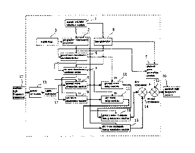
[0036]Fig.1 is a structure schematic diagram of a geographic information-based
simulation test system for medium-high frequency communication channels
according to
the present invention.
[003711n the figures:
[003811-human-machine interface module 2-geographic information processor
[0039]3-digital map 4-ground wave
characteristics calculation module
[004015-sky wave characteristics calculation module 6-time
generator
[0041]7-ambient noise generation module 8-ground wave attenuation module
[0042]9-sky wave attenuation module 10-ground wave delay module
[0043111-sky wave delay module 12-medium-high frequency transmitter
[0044]13-power attenuator 14-first synthesizer 15-second synthesizer
[0045116-medium-high frequency receiver 17-signal distributor
[0046118-ground wave multipath fading simulation module
[0047119-sky wave multipath fading simulation module
8
Date Recue/Date Received 2022-10-18
Detailed Description
[0048]The invention will now be further described below with reference to the
accompanying drawings and examples.
[0049]Fig.1 is a structure schematic diagram of a geographic information-based
simulation test system for medium-high frequency communication channels
according to
the present invention.
[0050] Please refer to Fig.1, the geographic information-based simulation test
system for
medium-high frequency communication channels comprising:
[0051]a human-machine interface module: inputting the frequency, geographical
coordinates, time range, communication availability (90% or 95%) of a
transmitter and a
receiver, the modulation mode of the transmitter and the receiver, the output
power of the
transmitter, the antenna height of the transmitter, the antenna type of the
transmitter, the
antenna height of the receiver, the antenna type and channel multipath
parameters of the
receiver, and controlling the start and end of simulation process. Channel
multipath
parameters include parameters such as delay, gain, Doppler frequency, and
Doppler
spread of multiple paths;
[0052]a geographic information processor: calculating the communication signal
transmission path between the transmitter and the receiver, the transmission
path
includes a ground wave transmission path and a sky wave transmission path;
[0053]a ground wave characteristics calculation module: calculating the
attenuation and
time delay under the mixed path and controlling the variable power attenuator
and time
9
Date Recue/Date Received 2022-10-18
delay module to adjust the transmitted signal according to the information
composition of
ground characteristics of various ground wave transmission paths;
[0054]a ground wave attenuation module: using variable power attenuator;
[0055] a ground wave delay module: using variable radio frequency signal
delay;
[0056]a ground wave multipath fading simulation module: carrying the multipath
fading
simulation of the signal output by the delay module to generate the ground
wave
transmission signal through the channel multipath parameters read by the human-
machine interface module;
[0057]a sky wave characteristics calculation module: calculating the
attenuation and
delay in mixed paths and controlling the variable power attenuator and time
delay module
to adjust the transmitted signal according to the information composition of
various sky
wave transmission paths;
[0058] a ground wave attenuation module: as the ground wave attenuation
module, using
variable power attenuator;
[0059] a sky wave delay module: as the ground wave delay module, using
variable radio
frequency signal delay;
[0060]a sky wave multipath fading simulation module: as the ground wave
multipath
fading simulation module, generating the ground wave transmission signal;
[0061]a digital map: storing global or regional geographic feature information
for
providing ground feature information to geographic information processors;
[0062]an ambient noise generation module: generating environment noise signal
of
receiver;
Date Recue/Date Received 2022-10-18
[0063]a time generator: controlling the time of the whole simulation system,
the time
generator reads the time range from the human-machine interface module, when
the
simulation is started, the time generator outputs the starting time to the
geographic
information processor, the ground wave characteristics calculation module, the
sky wave
characteristics calculation module and the ambient noise generation module,
and
continuously updating the time until the end;
[0064]a simulation signal synthesizer: synthesizing the ground wave
transmission signal,
sky wave transmission signal and environmental noise signal generated by
simulation.
[0065]The present invention calculate the transmission characteristics of
ground wave
and sky wave and the environmental noise of the receiver according to the
signal
characteristics of the medium-high frequency transmitter and receiver, the
actual working
geographical position and time range and other parameters. These parameters
include
the frequency of the input transmitter and receiver, the modulation mode, the
output
power of the transmitter, the antenna height of the transmitter, the antenna
type of the
transmitter, the antenna height of the receiver and the antenna type of the
receiver,
position coordinate, time range, channel multipath and other parameters.
Controlling the
work of the medium-high frequency channel simulator, simulating the signals
that the
receiver may actually receive in different geographical locations and
different time periods
according to the calculation results. The functions and realization of each
main module
are as follows:
[0066]A human-machine interface module 1: inputting the frequency, the
modulation
mode of the transmitter and the receiver, the output power of the transmitter,
the antenna
height of the transmitter, the antenna type of the transmitter, the antenna
height of the
11
Date Recue/Date Received 2022-10-18
receiver, the antenna type, position coordinates, time range and of the
receiver, channel
multipath of the receiver and other parameters . The human-machine interface
module
has the function of starting and ending simulation, and can control the speed
of simulation.
The human-machine interface module can be a computer, tablet computer or other
input
device.
[0067]A geographic information processor 2: calculating the communication
signal
transmission path between the transmitter and the receiver, the transmission
path
includes a ground wave transmission path and a sky wave transmission path. For
the
ground wave transmission path, the geographic information processor reads the
digital
map, extracts the information of the ground characteristics of the
transmission path, such
as low salt sea water, average salt sea water, fresh water, wetland surface,
medium dry
ground, dry ground, very dry ground, fresh water ice, etc., and outputs it to
the ground
wave characteristics calculation module. For the sky wave transmission path,
the
geographic information processor reads the digital map, extracts the
geomagnetic,
oceanic, ionospheric type and height information of the transmission path, and
outputs
them to the sky wave characteristics calculation module.
[0068]A digital map 3: storing global or regional geographic feature
information for
providing ground feature information to geographic information processors;
[0069]A ground wave characteristics calculation module 4: the attenuation Ll
and time
delay D1 under the mixed path composed of the information of the ground
characteristics
of the various ground wave transmission paths described in the geographic
information
processor 2 are calculated. The calculation of ground wave transmission mainly
refers to
the calculation method proposed in ITU-R p.368-9 proposal "ground wave
propagation
12
Date Recue/Date Received 2022-10-18
curve with frequency between 10 kHz and 30 MHz". The standard recommends the
use
of computer program GRWAVE to calculate the transmission curve. The computer
program GRWAVE can only calculate a single ground characteristic, that is, the
conductivity and relative permittivity remain unchanged, the actual
transmission route is
a mixed path, and the conductivity and relative permittivity change. The
ground wave
feature calculation module first automatically calculates the length of each
path with the
same ground feature under the mixed path, then calculates the attenuation and
delay
according to the conductivity and relative dielectric constant of each same
ground feature,
and finally comprehensively calculates the overall attenuation and delay under
the mixed
path.
[00701A sky wave characteristics calculation module 5: the attenuation L2 and
the delay
D2 under the mixed path composed of the information of the various sky wave
transmission paths described in the geographic information processor 2 are
calculated.
For the medium wave signal with frequency less than 1700 kHz, the sky wave
transmission with path length between 50 and 12000 km mainly refers to ITU-R
p.1147-
4 proposal "prediction of sky wave field strength with frequency between 150
and 1700
kHz". The difference lies in line gain factor, ocean gain, hourly loss factor,
loss factor of
comprehensive influence of solar activity, daily and short-term changes of
field strength
at night, coupling loss of over polarization, etc., which are improved from
reading curve
to fitting curve, automatic calculation by computer, and reading map of
magnetic
declination angle and magnetic inclination angle to automatic acquisition from
digital map
3. For the prediction of sky wave propagation with frequency between 2-30mhz,
it mainly
refers to ITU-R p.533-13 proposal prediction method of HF circuit performance.
The
13
Date Recue/Date Received 2022-10-18
difference is that the chart in the proposal is fitted so that the calculation
is completed
automatically.
[0071]A time generator 6: controlling the time of the whole simulation system,
the time
generator reads the time range from the human-machine interface module. The
input
format of time range is start time: "month-day -hour", end time: "month-day-
hour". The
minimum simulation range is a few hours of the specified month and date, and
the
maximum simulation range is a whole year. The time generator reads the
simulation
speed parameter K from the human-machine interface, which represents the ratio
of
simulation system time and simulation time, that is, k = simulation system
time / simulation
time. When k = 60, it means that one minute of operation of the simulation
system is
equivalent to one hour of simulation. When the simulation is started, the time
generator
outputs the starting time "month-day-hour" to the ground wave characteristics
calculation
module, the sky wave characteristics calculation module and the environment
noise
generation module, and updates the "month-day-hour" continuously and
continuously
according to the simulation speed until the end time or receiving the end
instruction.
[0072]An ambient noise generation module 7: used to generate environmental
noise at
the receiver. The ambient noise generation module obtains parameters such as
receiver
position coordinates, communication availability (90% or 95%) and time range
from the
human-machine interface. According to Recommendation ITU R P.372, the ITU
NOISEDAT software is called to calculate the parameters of the external noise
factor
median Fa, and the high decile Du from the median.
[0073]For the external noise factor corresponding to the required
availability, the upper
bound Fa shoud be calculated using equation (1) :
14
Date Recue/Date Received 2022-10-18
[0074] Fa = i, + Vq -FD, dB above k TO B (1)
[0075] wherein:
[0076] Fam: median external noise factor
[0077] Da: the expected signal level change for the required percentage of
time is
equivalent to a 3 dB factor specified by IMO as the fading margin
[0078] Dt: the expected change in noise level for the required percentage of
time.
[0079] If the communication availability is 90%, then Dt=Du;
[0080] If the communication availability is 95%, then Dt=Du+3,
[0081] K: Boltzmann constant=1.38 x10⁻²³ J/K;
[0082] To: reference temperature (K) is 290 K;
[0083] B: receive noise 1Hz power bandwidth (Hz);
[0084] The ambient noise generation module 7 finally generates the
environmental noise
Fr at the receiver.
[0085]The ground wave attenuation module 8 is a program-controlled variable
power
attenuator, which controls L1 from the ground wave characteristic calculation
output. The
sky wave attenuation module 9 is a program-controlled variable power
attenuator, which
controls L2 from the sky wave characteristic calculation output. The ground
wave delay
module 10 is a program-controlled radio frequency signal delay, which controls
D1 from
the ground wave characteristic calculation output. The sky wave delay module
11 is a
program-controlled radio frequency signal delayer, which controls D2 from the
sky wave
characteristic calculation output.
[0086]The ground wave multipath fading simulation module 18 is a wireless
multipath
channel emulator, which controls the channel multipath parameters manually
input from
Date Recue/Date Received 2022-10-18
the human-machine interface module 1, and the channel multipath parameters
include
delay, gain, and Doppt frequencies of multiple paths, Doppler expansion and
other
parameters. The wireless multi-path channel emulator can be a dedicated
wireless
channel emulator device or a device based on a software radio platform.
[0087]The sky wave multipath fading simulation module 19 is also a wireless
multipath
channel emulator, which controls the channel multipath parameters manually
input from
the man-machine interface module 1.
[0088]The medium-high frequency transmitter 12 is an equipment to be tested,
and
outputs a medium and high frequency radio signal. The power attenuator 13 is a
high-
power attenuator, which is used to attenuate the high-power radio signal
output by the
medium -high frequency transmitter to a small power to avoid damage to the
ground wave
attenuation and sky wave attenuation modules. The signal distributor 17 is
used to
distinguish the sky wave transmission signal from the ground wave transmission
signal.
The attenuation of the power attenuator must be deducted for ground wave
attenuation
and sky wave attenuation. The first synthesizer 14 synthesizes the signal
transmitted by
the ground wave output by the ground wave multipath fading and the sky wave
transmitted signal output by the sky wave multipath fading. The second
synthesizer 15
synthesizes the signal output by the first synthesizer 14 and the receiver
environmental
noise Fr output by the environmental noise generation module 7. The medium-
high
frequency transmitter 12 is an equipment to be tested, and receives the signal
output from
the second synthesizer 15.
[0089]While the present invention has been disclosed as above in preferred
embodiments, it is not intended to limit the invention. Any person skilled in
the art may
16
Date Recue/Date Received 2022-10-18
make various improvement and modifications within the spirit and scope of the
invention.
Therefore, the scope of protection of the invention shall be subject to that
defined in the
claims.
17
Date Recue/Date Received 2022-10-18