Note: Descriptions are shown in the official language in which they were submitted.
MICROSEISMIC VELOCITY MODELS DERIVED FROM
HISTORICAL MODEL CLASSIFICATION
FIELD OF THE DISCLOSURE
100011 The present disclosure relates generally to seismic velocity
modeling and
particularly, to generating seismic velocity models for well planning and
drilling.
BACKGROUND
[0002] Knowing the properties and locations of underground rock
formations is useful for
making decisions as to where and how to economically produce hydrocarbons from
io underground reservoirs. In the field of hydrocarbon exploration and
production, seismic
imaging techniques may be used to gain an understanding of the depth and
structures of
subsurface geological formations. Various seismic sources, such as dynamite,
"thumper"
trucks, air guns, and other noise sources located at the surface of a
hydrocarbon bearing field,
may be used to propagate seismic waves through an underground formation. The
propagated
is waves are reflected through the formation and acquired using various
seismic signal receiver
devices, for example, geophones, hydrophones, and the like. Seismic-data
traces including a
record of the sound wave reflections acquired from the underground formation
may be used to
generate three-dimensional images of subsurface geological structures,
including faults and
other stratigraphic features that trap hydrocarbon and mineral deposits. Wells
are drilled and
20 completed in these stratigraphic features and hydrocarbon traps with the
purpose of recovering
such deposits. In unconventional reservoirs or formations with very low
permeability, a
specialized completion strategy known as hydraulic fracture stimulation is
employed. These
stimulations increase the permeability of the formations and improve the
economic recovery
of the well.
25 [0003] During hydraulic fracture stimulations fluids are injected
into the well at rates and
pressures sufficient to break the formation as it exits the perforated holes.
Micro-earthquakes
are generated as the formation rock breaks down. Geophones run on wireline or
fiber-optic
cable in nearby offset wells can detect the sound waves emitted from these
rock breaks.
1
Date Recue/Date Received 2020-07-27
Application of a competent velocity model to the arrival times of the sound
waves facilitate
the location in two- or three-dimensional space. Seismic imaging and
microseismic location
analysis become more complex when the subsurface formation has fractures, a
preferred
orientation of grains, tectonic stress regimes or other geo-mechanical
variations. In such
cases, the subsurface medium of the formation layer being imaged may exhibit
seismically
anisotropic characteristics. Therefore, the velocity model employed in the
seismic imaging
and event location analysis needs to have a high level of accuracy and adhere
to geological,
petrophysical and geophysical properties.
BRIEF DESCRIPTION OF THE DRAWINGS
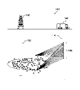
[0004] FIG. 1A is a side elevation view of a surface seismic survey system
for a
subsurface formation in accordance with one or more embodiments.
[0005] FIG. 1B is a side elevation view of a vertical seismic profile
(VSP) survey system
for the subsurface formation of FIG. 1A in accordance with one or more
embodiments.
[0006] FIG. 1C is a diagram of another VSP survey system for detecting
microseismic
is events within a formation surrounding a vertical well undergoing a
hydraulic fracture
stimulation treatment.
100071 FIG. 1D is a diagram of yet another VSP survey system for
detecting microseismic
events within a formation surrounding a horizontal or deviated well undergoing
a hydraulic
fracture stimulation treatment.
100081 FIG. 2 is a flowchart of a process for generating an initial
microseismic velocity
model for a planned wellsite in a hydrocarbon producing field based on
historical
microseismic velocity models associated with existing well sites in the field.
[0009] FIG. 3 is a view of a hydrocarbon producing field map including a
plurality of
previously mapped well sites surrounding a planned well site.
100101 FIG. 4 is a magnified view of the hydrocarbon field of FIG. 3
illustrating selected
well sites in proximity to the planned well site.
[0011] FIG. 5 is a table illustrating velocity components of historical
velocity models
associated with the selected well sites of FIG. 4.
2
Date Recue/Date Received 2020-07-27
[0012] FIGS. 6A, 6B, and 6C are data plots illustrating examples of the
best-fitting VP,
epsilon, and gamma velocity components, respectively, based on a non-linear
regression on
the historical velocity models.
100131 FIG. 7 is a table illustrating values of the best-fitting Vp, Vs,
delta, epsilon, and
gamma velocity model components sorted by true vertical depth (TVD) for a
planned well
site.
[0014] FIG. 8 is an illustrative visualization of velocity data for
different layer depths of
an initial microseismic velocity model derived from historical velocity
models.
100151 FIGS. 9A and 9B are wellbore diagrams illustrating a comparison
between
estimated perforation locations determined before and after optimizing an
initial velocity
model, respectively.
[0016] FIG. 10 is a block diagram of an exemplary computer system in
which
embodiments of the present disclosure may be implemented.
DESCRIPTION OF ILLUSTRATIVE EMBODIMENTS
[0017] Embodiments of the present disclosure relate to generating optimal
initial
microseismic velocity models based on historical velocity models. While the
present
disclosure is described herein with reference to illustrative embodiments for
particular
applications, it should be understood that embodiments are not limited
thereto. Other
embodiments are possible, and modifications can be made to the embodiments
within the
spirit and scope of the teachings herein and additional fields in which the
embodiments would
be of significant utility.
[0018] In the detailed description herein, references to "one
embodiment," "an
embodiment," "an example embodiment," etc., indicate that the embodiment
described may
include a particular feature, structure, or characteristic, but every
embodiment may not
necessarily include the particular feature, structure, or characteristic.
Moreover, such phrases
are not necessarily referring to the same embodiment. Further, when a
particular feature,
structure, or characteristic is described in connection with an embodiment, it
is submitted that
it is within the knowledge of one skilled in the relevant art to implement
such feature,
3
Date Recue/Date Received 2020-07-27
structure, or characteristic in connection with other embodiments whether or
not explicitly
described. It would also be apparent to one of skill in the relevant art that
the embodiments,
as described herein, can be implemented in many different embodiments of
software,
hardware, firmware, and/or the entities illustrated in the figures. Any actual
software code
with the specialized control of hardware to implement embodiments is not
limiting of the
detailed description. Thus, the operational behavior of embodiments will be
described with
the understanding that modifications and variations of the embodiments are
possible, given the
level of detail presented herein.
100191
As will be described in further detail below, embodiments of the present
disclosure
io .. may be used to generate optimized microseismic velocity models for
different microseismic
applications.
Such applications may include, for example, locating and monitoring
microseismic events of interest within a subsurface formation based on
microseismic data
captured using various seismic measurement devices. Examples of such devices
include, but
are not limited to, geophones, hydrophones, and fiber optic sensors for
measuring seismic
energy. In one or more embodiments, a microseismic velocity model for mapping
a new or
planned well site in a hydrocarbon producing field may be generated based on
historical
velocity models associated with one or more previously mapped well sites in
proximity to the
planned well site.
[0020]
It should be appreciated that the mapping of a well site in the context of
microseismic velocity modeling as described herein includes mapping the
subsurface
formation at the well site based on microseismic data derived from simulations
using one or
more microseismic velocity models or measurements obtained from an actual
seismic survey
of the formation or a combination thereof. For example, the velocity model
that is generated
for the planned well site may serve as an optimal starting point for
simulating seismic wave
.. propagation and estimating the locations of microseismic events of interest
within the
corresponding formation. The initial velocity model in this example may be
further optimized
based on new microseismic data collected by seismic measurement devices at the
planned
well site. By leveraging historical microseismic velocity data, the disclosed
techniques
provide more reliable starting microseismic velocity models that produce more
accurate
4
Date Recue/Date Received 2020-07-27
estimates of microseismic event locations relative to conventional velocity
modeling
techniques. This in turn reduces processing time and improves system
performance for real-
time microseismic applications at the well site.
[0021] Illustrative embodiments and related methodologies of the present
disclosure are
described below in reference to FIGS. 1-10 as they might be employed, for
example, in a
computer system for microseismic velocity modeling and reservoir simulation
applications.
Other features and advantages of the disclosed embodiments will be or will
become apparent
to one of ordinary skill in the art upon examination of the following figures
and detailed
description. It is intended that all such additional features and advantages
be included within
the scope of the disclosed embodiments. Further, the illustrated figures are
only exemplary
and are not intended to assert or imply any limitation with regard to the
environment,
architecture, design, or process in which different embodiments may be
implemented.
100221 FIG. 1A is a side elevation view of a surface seismic survey
system 100A for a
subsurface formation 102 in accordance with one or more embodiments.
Subsurface
formation 102 may be, for example, a hydrocarbon bearing formation including a
plurality of
rock layers at varying depths. System 100A may be used to conduct a surface
seismic survey
that provides a seismic mapping of formation 102. System 100A includes a
seismic source
104A and an array of seismic receivers 108A. As shown in FIG. 1A, seismic
source 104A
may be a specialized "thumper" truck that generates seismic energy 106A.
However, it
should be noted that embodiments are not limited thereto and that seismic
source 104A may
be implemented using any of various other types of seismic sources including,
but not limited
to, air guns, dynamite or other types of explosives.
[0023] In conducting the surface seismic survey, seismic energy 106A may
be shot from
source 104A in the form of pulses or waves that propagate to and encounter
different layers of
formation 102. For each layer encountered, a portion of seismic energy 106A is
reflected
towards the earth's face and received by one or more of seismic receivers 108A
at the surface.
Seismic receivers 108A may be any of various seismic measurement devices
located at the
Earth's surface or downhole at the depth of the target formation 102. Such
devices may
include, for example and without limitation, a geophone, hydrophone, fiber
optic sensors, e.g.,
5
Date Recue/Date Received 2020-07-27
distributed acoustic sensing (DAS) devices, or any other seismic measurement
device for
detecting and measuring waves of seismic energy 106A shot from source 104A and
recording
arrival times and amplitudes of the detected waves.
[0024] The surface seismic survey conducted using system 100A may be,
for example, an
initial exploratory survey conducted over a relatively large area of earth to
obtain a relatively
low-resolution mapping of the geometry of subsurface formation 102. Such a
broad-based
seismic survey may be used in conjunction with core samples and/or well logs
from one or
more exploratory wellbores for purposes of hydrocarbon exploration and well
planning. From
the initial exploratory survey, a determination may be made as to a particular
location within
formation 102 that is likely to contain hydrocarbons. For further exploration
and planning
purposes, a more detailed vertical seismic profile (VSP) survey of the
particular location may
be conducted, as illustrated by the example shown in FIG. 1B.
100251 FIG. 1B is a side elevation view of a seismic survey system 100B
for conducting a
VSP survey of subsurface formation 102 in accordance with one or more
embodiments. As
is shown in FIG. 1B, a drilling rig 110B at the surface may be used to
drill a wellbore 112B into
different layers of formation 102. A plurality of seismic sources 104B at the
surface are used
to generate seismic energy 106B that propagates through the different layers
of formation 102,
as described above. It should be appreciated that any number of seismic
sources may be used
as desired for a particular implementation. Seismic sources 104B may be
implemented using
any of various seismic source devices, e.g., dynamite or other explosives,
thumper trucks, air
guns, or other noise sources. The waves of seismic energy 106B and direct
arrival times from
sources 104B are detected and recorded by an array of seismic receivers 108B
disposed within
wellbore 112B. Seismic receivers 108B may be, for example, an array of
downhole seismic
measurement devices, e.g., geophones, hydrophones or fiber optic sensors,
coupled to or
integrated within a bottom hole assembly of a drill string or wireline logging
tool disposed
within borehole 112B.
[0026] In one or more embodiments, seismic receivers 108B may be used to
record
microseismic data including measured or observed travel times of seismic
energy waves
generated by seismic sources 104B. Such travel time data may include, for
example, first
6
Date Recue/Date Received 2020-07-27
arrival times of direct qP-wave and/or qS-wave propagations between different
seismic
sources 104B and seismic receivers 108B. In one or more embodiments, the
seismic receivers
of the seismic survey system may be used to detect microseismic events, such
as
microearthquakes, caused by downhole operations within the wellbore, as will
be described in
further detail below with respect to FIGS. 1C and 1D.
[0027] FIG. 1C is a diagram of a VSP survey system 100C for detecting
microseismic
events within a formation surrounding a vertical well 112C undergoing a
hydraulic fracture
stimulation treatment. The hydraulic fracture stimulation treatment in this
example may
involve injecting a fracturing fluid from a drilling rig 110C into the
formation via perforations
along vertical well 112C. As shown in FIG. 1C, seismic receivers 108C in an
offset well
114C near vertical well 112C may be used to detect microearthquakes caused by
the fluid
injection in an area of the formation surrounding vertical well 112C. Seismic
receivers 108C
may be any of various seismic measurement devices for detecting and recording
the sound
waves emitted by the microearthquakes from the slipping of micro fault planes
within the
formation. Examples of such measurement devices include, but are not limited
to, geophones,
hydrophones, fiber optic sensors, e.g., distributed acoustic sensing (DAS)
devices. The
microseismic data recorded by seismic receivers 108C may then be transmitted
to a control
system 104C at the surface of offset well 114C for processing. In one or more
embodiments,
control system 104C may include a data processing device or computer system
that applies the
microseismic data as inputs to a microseismic velocity model for estimating
the locations of
the microearthquakes in a two-dimensional or three-dimensional space
corresponding to the
relevant formation area surrounding vertical well 112C.
[0028] In a similar example, FIG. 1D illustrates a VSP survey system
100D for detecting
microseismic events within an area of the formation surrounding a horizontal
or deviated well
112D associated with a drilling rig 110D. Like vertical well 112C of FIG. 1C,
well 112D may
be undergoing a hydraulic fracture stimulation treatment in which fracturing
fluid is injected
into the formation via perforations along a horizontal/deviated portion of
well 112D. The
microearthquakes generated by the stimulation treatment in this example are
detected and
recorded by seismic receivers 108D in an offset well 114D. The recorded data
is transmitted
7
Date Recue/Date Received 2020-07-27
to a surface control system 104D for processing. Like, control system 104C of
FIG. 1C,
control system 104D may include a computer system that applies the
microseismic data as
inputs to a microseismic velocity model for estimating the locations of the
microearthquakes
in a two-dimensional or three-dimensional space corresponding to the relevant
formation area
surrounding well 112D. While the offset wells are shown in FIGS. 1C and 1D as
vertical
wells, it should be appreciated that the disclosed techniques may be applied
using other VSP
system configurations with seismic measurement devices disposed within
deviated offsets
wells.
100291 In one or more embodiments, the microseismic velocity model used
to process the
microseismic data in VSP systems 100C and 100D of FIGS. 1C and 1D, as
described above,
may be an initial microseismic velocity model generated from historical
velocity models. In
some cases, the microseismic data collected by the seismic receivers in the
above examples
may be used to optimize or refine the initial microseismic velocity model. The
historical
velocity models used to generate the initial model in this example may be
associated with one
or more previously mapped well sites within the same hydrocarbon producing
field, which are
located near or within a predetermined distance of a planned well site to be
mapped using the
initial microseismic velocity model, as will be described in further detail
below.
[0030] FIG. 2 is a flowchart of a process 200 for generating an initial
microseismic
velocity model to map the subsurface of a planned wellsite in a hydrocarbon
producing field
based on historical microseismic velocity models corresponding to previously
mapped well
sites in the field. For purposes of discussion, process 200 may be described
with reference to
systems 100A and 100B of FIGS. 1A and 1B, respectively, as described above.
However,
process 200 is not intended to be limited thereto.
[0031] As shown in the example of FIG. 2, process 200 may begin in block
202, which
includes selecting one or more existing well sites in proximity to a planned
well site within a
hydrocarbon producing field. In one or more embodiments, the one or more
existing well
sites may be selected from a plurality of previously mapped well sites within
the field, as
illustrated in FIG. 3. FIG. 3 is a view 300 of a hydrocarbon producing field
map including a
plurality of previously mapped well sites surrounding a planned well site 302.
The existing
8
Date Recue/Date Received 2020-07-27
well sites, which are selected from the plurality of previously mapped well
sites in the
example shown in FIG. 3, may be located within an area 310 surrounding well
site 302. In
one or more embodiments, the well sites are selected based on user input
received via a
graphical user interface (GUI) of a reservoir simulation application
executable at the user's
device. Accordingly, view 300 of the hydrocarbon producing field map may be
displayed
within an interactive window of the GUI, which may provide various user
control elements
that the user can manipulate for viewing and selecting different well sites.
For example, the
GUI may provide a set of view controls 320 within view 300 may include a
slider control 322
that allows the user to control a zoom level or magnification of the
hydrocarbon producing
field as shown within view 300 using a user input device, e.g., a touch-
screen, mouse or other
pointer device. Thus, the user in this example may use the slider control 322
to zoom-in or
magnify the portion of view 300 near area 310.
100321 FIG. 4 shows an example of a magnified view 400 of the
hydrocarbon field map of
FIG. 3, which may be displayed within the above-described GUI as a result of
input received
from the user via slide control 322. The user may then specify the previously
mapped well
sites of interest by using the user input device to select a visual indicator
or marker
corresponding to each well site as displayed within the GUI. As illustrated by
the example in
FIG. 4, the user may select well sites 412a, 412b, 412c and 412d (or
collectively, "well sites
412a-d") that are in proximity to planned well site 302 and within an area 410
of magnified
view 400 of the hydrocarbon field map. In one or more embodiments, the
proximity of each
previously mapped well site to the planned well site within the field may be
based on a
predetermined distance that serves as a maximum threshold to limit the well
sites that may be
selected to only those within a certain radius of the planned well site. Thus,
well sites 412a-d
in FIG. 4 may be previously mapped well sites that are located within, i.e.,
no further than, a
predetermined distance from planned well site 302.
[0033] In one or more embodiments, the proximity of each previously
mapped well site to
the planned well site may be only one of the factors considered in the
selection. For example,
in addition to the proximity of each previously mapped well site to the
planned well site, the
selection of well sites may also consider the degree of similarity between one
or more
9
Date Recue/Date Received 2020-07-27
formation properties associated with the planned well site and those
associated with each of
the previously mapped sites. Examples of formation properties that may be
considered
include, but are not limited to, formation depth, permeability, porosity, and
any other
geological or lithological property that can be used to distinguish one
formation from another.
The degree of similarity between the formation properties of a previously
mapped well site
and the new well site to be mapped may be based on a comparison of well logs
from the
respective well sites.
100341 In some implementations, the degree of similarity between the
previously mapped
sites and the planned well site may be determined by clustering the previously
mapped well
sites according to location and shared formation properties relative to those
of the planned
well site. It should be appreciated that any of various clustering techniques
may be used for
this purpose. For example, K-Means clustering may be used to cluster the
previously mapped
well sites according to their respective locations, e.g., based on XYZ
coordinates of each well
site as obtained from a global positioning system (GPS) and a formation
property, such as
depth.
[0035] Returning to FIG. 2, once the one or more existing well sites
have been selected in
block 202, process 200 may proceed to block 204, which includes obtaining
historical
microseismic velocity models associated with the selected well sites. In one
or more
embodiments, the historical velocity models may be obtained from a historical
database
including a repository of microseismic velocity models that were previously
generated for
operations conducted at each of the previously mapped well sites in the field.
It should be
appreciated that the database may also store the microseismic velocity models
for prior
operations at well sites in other fields, including those with similar
subsurface formation
properties as the well sites in the current field of interest. The historical
velocity models
obtained for the selected well sites may include a plurality of velocity
components. FIG. 5 is a
table 500 illustrating velocity components of historical velocity models that
may be associated
with the well sites selected in block 202, e.g., selected well sites 412a-d of
FIG. 4, as
described above. As shown in table 500, the velocity components of each model
may include,
for example and without limitation, Primary (Vp), Secondary (Vs), Delta,
Epsilon, and
Date Recue/Date Received 2020-07-27
Gamma, as calculated or measured over different formation depths, e.g., true
vertical depth
(TVD) in units of feet.
[0036] Returning again to FIG. 2, the depths for each velocity component
of the historical
velocity models obtained in block 204 of process 200 may be correlated to TVD
data acquired
for the planned well site in block 206. In one or more embodiments, the TVD
data for the
planned well site may be acquired from well logs obtained from exploratory or
offset wells
drilled at or near the planned well site. The acquired TVD data from the well
logs may then
be compared with the TVD data from the historical velocity models obtained in
block 204 for
the existing well sites selected in block 202 to ensure the formation depths
associated with the
selected well sites are sufficiently similar to those of the planned well
site. In cases where
there is a significant difference in TVD between a selected well site and the
planned well site,
appropriate depth adjustments may be made to the corresponding historical
velocity models of
the selected well site such that the correlation between the historical and
new formation depths
is within an acceptable or predetermined tolerance range for a particular
implementation. In
one or more embodiments, block 206 may further include performing a
classification and non-
linear regression on the historical microseismic velocity models obtained in
block 204 to
identify the best-fitting velocity components and then, correlating the depths
of the best-fitting
velocity components to the TVD data for the planned well site. The
classification and
regression in block 206 may be performed after making any adjustments to the
historical
velocity models based on the depth comparisons described above. FIGS. 6A, 6B,
and 6C are
data plots 600A, 600B and 600C illustrating examples of the best-fitting Vp,
epsilon, and
gamma velocity components, respectively, based on a non-linear regression on
the historical
velocity models. FIG. 7 is a table 700 illustrating values of the best-fitting
Vp, Vs, delta,
epsilon, and gamma velocity model components sorted by TVD for a planned well
site.
100371 In some implementations, process 200 may proceed to blocks 208 and
210 for
verifying whether the correlation between the depths associated with each
velocity component
of the historical microseismic velocity models and depths associated with the
well log data
acquired for the planned well site is within a predetermined acceptable
accuracy range. When
the correlation is determined not to be within the predetermined accuracy
range in block 210,
11
Date Recue/Date Received 2020-07-27
process 200 may return to block 202 and the operations in blocks 202, 204, and
206 for
selecting, obtaining, and correlating, respectively, may be repeated until the
correlation is
determined to be within the predetermined accuracy range. However, as
indicated in by the
dotted lines in FIG. 2, the verification operations in blocks 208 and 210 may
be optional and
performed as needed or desired for a particular implementation.
[0038] Once the depths are correlated (and the correlation verified),
process 200 may
proceed to block 212, which includes generating an initial microseismic
velocity model for the
planned well site, based on the correlated depths. The initial microseismic
velocity model
generated in block 212 may include a plurality of layers corresponding to the
correlated
depths. FIG. 8 is an illustrative visualization 800 showing an example of
velocity data for
different layer depths of an initial microseismic velocity model including
velocity components
derived from the correlated depths of historical velocity model components, as
described
above.
[0039] In block 214, the initial microseismic velocity model generated
for the planned
is well site may be used to simulate seismic wave propagation through
different formation layers
represented by the model. In block 216, the locations of one or more
microseismic events of
interest within the subsurface formation associated with the planned well
site, based on the
simulated wave propagation. Such events may be any of various seismic events
that can occur
within the subsurface formation, including, but not limited to, earthquakes
and perforating
events for creating perforations within the formation during downhole
operations at the well
site.
[0040] In one or more embodiments, measurements indicating the actual
locations of the
one or more microseismic events of interest within the subsurface formation
may be acquired
from one or more seismic measurement devices during a downhole operation at
the planned
well site. The actual locations of the one or more microseismic events of
interest may be
compared to the locations estimated using the initial microseismic velocity
model. Any
difference determined from the comparison between the actual and estimated
locations, may
be used to optimize or refine the initial microseismic velocity model and
thereby, improve the
accuracy of the model for estimating locations of the events during subsequent
stages of the
12
Date Recue/Date Received 2020-07-27
downhole operation. For example, the downhole operation may be a multistage
hydraulic
fracturing operation, and the microseismic events of interest may include
perforating events
associated with perforating devices creating fluid injection points along a
length of a wellbore
within the subsurface formation. Accordingly, actual microseismic data
acquired for events of
interest during a current stage of the downhole operation along the wellbore
may be used to
update the initial velocity model and produce more accurate estimates of event
locations for a
subsequent stage of the operation.
100411 FIGS. 9A and 9B are wellbore diagrams 900A and 900B illustrating
a comparison
between estimated perforation locations along a wellbore 910 before and after
optimizing an
initial velocity model, respectively, as described above. The model in this
example may be
optimized based on actual microseismic data acquired during downhole
operations along
wellbore 910. In FIG. 9A, an estimated location 912A of the perforations using
the initial
velocity model substantially deviates from their expected location within the
formation
adjacent to wellbore 910. By contrast, FIG. 9B shows that the optimized
velocity model
is produces a more accurate estimated location 912B of the perforations
that coincides with the
expected location adjacent to wellbore 910.
100421 By improving the accuracy of location estimates for such events
of interest, the
disclosed velocity modeling techniques provide a significant reduction in the
post-processing
time that is typically needed to adjust or clean up event locations, e.g.,
perforating locations,
selected during various stages of a microseismic mapping projects. Having a
competent
velocity model in the early stages of a real-time mapping project ensures more
location
accuracy and eliminates the need to continuously update the velocity model,
recalculate the
locations during a later stage for all previous stages, and spending a great
deal of time to
reduce the number of velocity models that are in use. Further, the initial
velocity models
generated using the disclosed techniques may be used to automate the locating
of relevant
events for microseismic surveys using fiber-optic equipment. Such models may
provide a
solution to the optimization problems generally associated with velocity
models used in
microseismic operations involving the deployment of fiber in a treatment or
offset well
without having a vertical geophone array nearby.
13
Date Recue/Date Received 2020-07-27
[0043] FIG. 10 is a block diagram of an exemplary computer system 1000
in which
embodiments of the present disclosure may be implemented. For example, process
300 of
FIG. 3, as described above, may be implemented using system 1000. System 1000
can be a
computer, phone, PDA, or any other type of electronic device. Such an
electronic device
includes various types of computer readable media and interfaces for various
other types of
computer readable media. As shown in FIG. 10, system 1000 includes a permanent
storage
device 1002, a system memory 1004, an output device interface 1006, a system
communications bus 1008, a read-only memory (ROM) 1010, processing unit(s)
1012, an
input device interface 1014, and a network interface 1016.
[0044] Bus 1008 collectively represents all system, peripheral, and chipset
buses that
communicatively connect the numerous internal devices of system 1000. For
instance, bus
1008 communicatively connects processing unit(s) 1012 with ROM 1010, system
memory
1004, and permanent storage device 1002.
[0045] From these various memory units, processing unit(s) 1012
retrieves instructions to
is execute and data to process in order to execute the processes of the
subject disclosure. The
processing unit(s) can be a single processor or a multi-core processor in
different
implementations.
[0046] ROM 1010 stores static data and instructions that are needed by
processing unit(s)
1012 and other modules of system 1000. Permanent storage device 1002, on the
other hand, is
a read-and-write memory device. This device is a non-volatile memory unit that
stores
instructions and data even when system 1000 is off Some implementations of the
subject
disclosure use a mass-storage device (such as a magnetic or optical disk and
its corresponding
disk drive) as permanent storage device 1002.
[0047] Other implementations use a removable storage device (such as a
floppy disk, flash
drive, and its corresponding disk drive) as permanent storage device 1002.
Like permanent
storage device 1002, system memory 1004 is a read-and-write memory device.
However,
unlike storage device 1002, system memory 1004 is a volatile read-and-write
memory, such a
random access memory. System memory 1004 stores some of the instructions and
data that
the processor needs at runtime. In some implementations, the processes of the
subject
14
Date Recue/Date Received 2020-07-27
disclosure are stored in system memory 1004, permanent storage device 1002,
and/or ROM
1010. For example, the various memory units include instructions for
performing the
microseismic velocity modeling techniques disclosed herein. From these various
memory
units, processing unit(s) 1012 retrieves instructions to execute and data to
process in order to
.. execute the processes of some implementations, e.g., process 200 of FIG. 2
as described
above.
[0048] Bus 1008 also connects to input and output device interfaces 1014
and 1006. Input
device interface 1014 enables the user to communicate information and select
commands to
the system 1000. Input devices used with input device interface 1014 include,
for example,
alphanumeric, QWERTY, or T9 keyboards, microphones, and pointing devices (also
called
"cursor control devices"). Output device interfaces 1006 enables, for example,
the display of
images generated by the system 1000. Output devices used with output device
interface 1006
include, for example, printers and display devices, such as cathode ray tubes
(CRT) or liquid
crystal displays (LCD). Some implementations include devices such as a
touchscreen that
is functions as both input and output devices. It should be appreciated
that embodiments of the
present disclosure may be implemented using a computer including any of
various types of
input and output devices for enabling interaction with a user. Such
interaction may include
feedback to or from the user in different forms of sensory feedback including,
but not limited
to, visual feedback, auditory feedback, or tactile feedback. Further, input
from the user can be
received in any form including, but not limited to, acoustic, speech, or
tactile input.
Additionally, interaction with the user may include transmitting and receiving
different types
of information, e.g., in the form of documents, to and from the user via the
above-described
interfaces.
[0049] Also, as shown in FIG. 10, bus 1008 also couples system 1000 to a
public or
private network (not shown) or combination of networks through a network
interface 1016.
Such a network may include, for example, a local area network ("LAN"), such as
an Intranet,
or a wide area network ("WAN"), such as the Internet. Any or all components of
system 1000
can be used in conjunction with the subject disclosure.
Date Recue/Date Received 2020-07-27
[0050] These functions described above can be implemented in digital
electronic circuitry,
in computer software, firmware or hardware. The techniques can be implemented
using one
or more computer program products. Programmable processors and computers can
be
included in or packaged as mobile devices. The processes and logic flows can
be performed
by one or more programmable processors and by one or more programmable logic
circuitry.
General and special purpose computing devices and storage devices can be
interconnected
through communication networks.
100511 Some implementations include electronic components, such as
microprocessors,
storage and memory that store computer program instructions in a machine-
readable or
io computer-readable medium (alternatively referred to as computer-readable
storage media,
machine-readable media, or machine-readable storage media). Some examples of
such
computer-readable media include RAM, ROM, read-only compact discs (CD-ROM),
recordable compact discs (CD-R), rewritable compact discs (CD-RW), read-only
digital
versatile discs (e.g., DVD-ROM, dual-layer DVD-ROM), a variety of
recordable/rewritable
DVDs (e.g., DVD-RAM, DVD-RW, DVD+RW, etc.), flash memory (e.g., SD cards, mini-
SD
cards, micro-SD cards, etc.), magnetic and/or solid state hard drives, read-
only and recordable
Blu-Ray discs, ultra-density optical discs, any other optical or magnetic
media, and floppy
disks. The computer-readable media can store a computer program that is
executable by at
least one processing unit and includes sets of instructions for performing
various operations.
Examples of computer programs or computer code include machine code, such as
is produced
by a compiler, and files including higher-level code that are executed by a
computer, an
electronic component, or a microprocessor using an interpreter.
[0052] While the above discussion primarily refers to microprocessor or
multi-core
processors that execute software, some implementations are performed by one or
more
integrated circuits, such as application specific integrated circuits (ASICs)
or field
programmable gate arrays (FPGAs). In some implementations, such integrated
circuits
execute instructions that are stored on the circuit itself Accordingly, the
operations for
performing process 200 of FIG. 2, as described above, may be implemented using
system
1000 or any computer system having processing circuitry or a computer program
product
16
Date Recue/Date Received 2020-07-27
including instructions stored therein, which, when executed by at least one
processor, causes
the processor to perform functions relating to these methods.
[0053] As used in this specification and any claims of this application,
the terms
"computer", "server", "processor", and "memory" all refer to electronic or
other technological
devices. These terms exclude people or groups of people. As used herein, the
terms
"computer readable medium" and "computer readable media" refer generally to
tangible,
physical, and non-transitory electronic storage mediums that store information
in a form that
is readable by a computer.
100541 Embodiments of the subject matter described in this specification
can be
implemented in a computing system that includes a back end component, e.g., as
a data server,
or that includes a middleware component, e.g., an application server, or that
includes a front
end component, e.g., a client computer having a graphical user interface or a
Web browser
through which a user can interact with an implementation of the subject matter
described in
this specification, or any combination of one or more such back end,
middleware, or front end
components. The components of the system can be interconnected by any form or
medium of
digital data communication, e.g., a communication network. Examples of
communication
networks include a local area network ("LAN") and a wide area network ("WAN"),
an inter-
network (e.g., the Internet), and peer-to-peer networks (e.g., ad hoc peer-to-
peer networks).
[0055] The computing system can include clients and servers. A client
and server are
generally remote from each other and typically interact through a
communication network.
The relationship of client and server arises by virtue of computer programs
running on the
respective computers and having a client-server relationship to each other. In
some
embodiments, a server transmits data (e.g., a web page) to a client device
(e.g., for purposes of
displaying data to and receiving user input from a user interacting with the
client device).
Data generated at the client device (e.g., a result of the user interaction)
can be received from
the client device at the server.
[0056] It is understood that any specific order or hierarchy of steps in
the processes
disclosed is an illustration of exemplary approaches. Based upon design
preferences, it is
understood that the specific order or hierarchy of steps in the processes may
be rearranged, or
17
Date Recue/Date Received 2020-07-27
that all illustrated steps be performed. Some of the steps may be performed
simultaneously.
For example, in certain circumstances, multitasking and parallel processing
may be
advantageous. Moreover, the separation of various system components in the
embodiments
described above should not be understood as requiring such separation in all
embodiments. It
should be appreciated that the described program components and systems can
generally be
integrated together in a single software product or packaged into multiple
software products.
[0057] Furthermore, the exemplary methodologies described herein may be
implemented
by a system including processing circuitry or a computer program product
including
instructions which, when executed by at least one processor, causes the
processor to perform
any of the methodology described herein.
[0058] As described above, embodiments of the present disclosure are
particularly useful
for producing an optimal starting velocity model for new microseismic mapping
projects.
Accordingly, advantages of the present disclosure include increased accuracy
of event
locations during real-time mapping of subsurface geological structures for
hydrocarbon
is exploration and production, reduced time and costs for optimizing
velocity models during
both real-time and post-processing phases of well site operations, e.g., for
purposes of "self-
tuning" a database or repository of historical velocity models from previously
mapped wells
as these new velocity models are incorporated after job completion. For
example, a Support
Vector Machine (SVM) algorithm may be used to classify the individual velocity
components
(e.g., Vp, Vs, delta, epsilon, and gamma components) of each model into near
equal parts,
dividing the dataset by a non-linear regression. This regression may be
improved by using the
input historical velocity data to further train the algorithm to provide a
more accurate
classification. This process may be repeated for all velocity components. The
(x, y) pairs
from the resulting trained regression lines from all velocity components may
be used to define
the output velocity model, e.g., as described above with respect to FIG. 7.
The depth range of
recording for mapping a new project well may then be compared to the output
velocity model
to determine and select the velocities that fall within that range. This
revised velocity model
may then be used for the new mapping project.
18
Date Recue/Date Received 2020-07-27
[0059] A computer-implemented method of generating microseismic velocity
models has
been described. Embodiments of the method may include: selecting, by a
computer system,
one or more existing well sites in proximity to a planned well site; obtaining
historical
microseismic velocity models associated with the one or more existing well
sites, each of the
historical microseismic velocity models including a plurality of velocity
components for
different formation depths; correlating the formation depths for each velocity
component of
the historical microseismic velocity models to formation depths from well logs
acquired for a
subsurface formation associated with the planned well site; performing a
classification and
non-linear regression on the historical microseismic velocity models to
identify the best-fitting
io velocity components for layers of the subsurface formation corresponding
to the correlated
formation depths; generating an initial microseismic velocity model of the
subsurface
formation for the planned well site using the best-fitting velocity
components; simulating
seismic wave propagation through each layer of the subsurface formation using
the initial
microseismic velocity model generated for the planned well site; and
estimating locations of
one or more microseismic events of interest within the subsurface formation
associated with
the planned well site, based on the simulated wave propagation.
100601 Likewise, embodiments of a computer-readable storage medium
having
instructions stored therein have been described, where the instructions, when
executed by a
processor, may cause the processor to perform a plurality of functions,
including functions to:
select one or more existing well sites in proximity to a planned well site;
obtain historical
microseismic velocity models associated with the one or more existing well
sites, each of the
historical microseismic velocity models including a plurality of velocity
components for
different formation depths; correlate the formation depths for each velocity
component of the
historical microseismic velocity models to formation depths from well logs
acquired for a
subsurface formation associated with the planned well site; perform a
classification and non-
linear regression on the historical microseismic velocity models to identify
the best-fitting
velocity components for layers of the subsurface formation corresponding to
the correlated
formation depths; generate an initial microseismic velocity model of the
subsurface formation
for the planned well site using the best-fitting velocity components; simulate
seismic wave
19
Date Recue/Date Received 2020-07-27
propagation through each layer of the subsurface formation using the initial
microseismic
velocity model generated for the planned well site; and estimate locations of
one or more
microseismic events of interest within the subsurface formation associated
with the planned
well site, based on the simulated wave propagation.
100611 The foregoing embodiments of the method or computer-readable storage
medium
may include any one or any combination of the following elements, features,
functions, or
operations: performing a downhole operation at the planned well site, based on
the estimated
locations of the one or more microseismic events of interest; comparing the
formation depths
associated with the one or more existing well sites to the depth data
associated with the
planned well site, determining whether a difference in formation depth between
the planned
well site and at least one of the existing well sites exceeds a predetermined
tolerance range,
based on the comparison, and when the difference in formation depth is
determined to exceed
the predetermined tolerance range, adjusting one or more of the historical
microseismic
velocity models such that the difference in formation depth is within the
predetermined
tolerance range; determining whether the correlation between the formation
depths associated
with each velocity component of the historical microseismic velocity models
and the
formation depths associated with the well logs acquired for the planned well
site is within a
predetermined accuracy range and when the correlation is determined not to be
within the
predetermined accuracy range, repeating the selecting, the obtaining, and the
correlating until
the correlation is determined to be within the predetermined accuracy range,
wherein the
initial microseismic velocity model is generated in response to determining
that the correlation
is within the predetermined accuracy range; acquiring, from one or more
seismic measurement
devices, microseismic data indicating actual locations of the one or more
microseismic events
of interest within the subsurface formation, comparing the actual locations of
the one or more
microseismic events of interest with the corresponding locations estimated
using the initial
microseismic velocity model, determining a difference between the actual and
estimated
locations, based on the comparison, and refining the initial microseismic
velocity model based
on the difference.
Date Recue/Date Received 2020-07-27
[0062] The downhole operation in one or more of the foregoing
embodiments of the
method or computer-readable storage medium may be a hydraulic fracturing
operation, and
the microseismic events of interest may include perforating events associated
with perforating
devices creating fluid injection points along a length of a wellbore within
the subsurface
formation. Furthermore, the one or more existing well sites in these one or
more
embodiments of the method or the computer-readable storage medium may be
selected from a
plurality of previously mapped well sites within a hydrocarbon producing
field, and the
historical microseismic velocity models associated with the one or more
existing well sites
may be obtained from a database of historical microseismic velocity models for
each of the
io plurality of previously mapped well sites, where selected well sites may
include previously
mapped well sites within a predetermined distance of the planned well site or
previously
mapped well sites that are selected based on proximity and a degree of
similarity between
formation properties of each previously mapped well site and the planned well
site.
[0063] Also, embodiments of a system including at least one processor
and a memory
is coupled to the processor have been described, where the memory stores
instructions, which,
when executed by a processor, may cause the processor to perform a plurality
of functions,
including functions to: select one or more existing well sites in proximity to
a planned well
site; retrieve historical microseismic velocity models associated with the one
or more existing
well sites, each of the historical microseismic velocity models including a
plurality of velocity
20 components for different formation depths; correlate the formation
depths for each velocity
component of the historical microseismic velocity models to formation depths
from well logs
acquired for a subsurface formation associated with the planned well site;
perform a
classification and non-linear regression on the historical microseismic
velocity models to
identify the best-fitting velocity components for layers of the subsurface
formation
25 corresponding to the correlated formation depths; generate an initial
microseismic velocity
model of the subsurface formation for the planned well site using the best-
fitting velocity
components; simulate seismic wave propagation through each layer of the
subsurface
formation using the initial microseismic velocity model generated for the
planned well site;
21
Date Recue/Date Received 2020-07-27
and estimate locations of one or more microseismic events of interest within
the subsurface
formation associated with the planned well site, based on the simulated wave
propagation.
[0064] In one or more of the foregoing embodiments of the system, the
functions
performed by the processor may further include any one or any combination of
functions to:
perform a downhole operation at the planned well site, based on the estimated
locations of the
one or more microseismic events of interest; compare the formation depths
associated with the
one or more existing well sites to the depth data associated with the planned
well site;
determine whether a difference in formation depth between the planned well
site and at least
one of the existing well sites exceeds a predetermined tolerance range, based
on the
comparison; when the difference in formation depth is determined to exceed the
predetermined tolerance range, adjust one or more of the historical
microseismic velocity
models such that the difference in formation depth is within the predetermined
tolerance
range; determine whether the correlation between the formation depths
associated with each
velocity component of the historical microseismic velocity models and the
formation depths
associated with the well logs acquired for the planned well site is within a
predetermined
accuracy range; when the correlation is determined not to be within the
predetermined
accuracy range, repeat the selection of existing well sites, the retrieval of
historical
microseismic velocity models, and the correlation of formation depths until
the correlation is
determined to be within the predetermined accuracy range, wherein the initial
microseismic
velocity model is generated in response to determining that the correlation is
within the
predetermined accuracy range; acquire, from one or more seismic measurement
devices,
microseismic data indicating actual locations of the one or more microseismic
events of
interest within the subsurface formation; compare the actual locations of the
one or more
microseismic events of interest with the corresponding locations estimated
using the initial
microseismic velocity model; determine a difference between the actual and
estimated
locations, based on the comparison; and refine the initial microseismic
velocity model based
on the difference.
[0065] The downhole operation in one or more of the foregoing
embodiments of the
system may be a hydraulic fracturing operation, and the microseismic events of
interest may
22
Date Recue/Date Received 2020-07-27
include perforating events associated with perforating devices creating fluid
injection points
along a length of a wellbore within the subsurface formation. Furthermore, the
one or more
existing well sites in these one or more embodiments of the system may be
selected from a
plurality of previously mapped well sites within a hydrocarbon producing
field, and the
historical microseismic velocity models associated with the one or more
existing well sites
may be obtained from a database of historical microseismic velocity models for
each of the
plurality of previously mapped well sites, where selected well sites may
include previously
mapped well sites within a predetermined distance of the planned well site or
previously
mapped well sites that are selected based on proximity and a degree of
similarity between
formation properties of each previously mapped well site and the planned well
site.
[0066] While specific details about the above embodiments have been
described, the
above hardware and software descriptions are intended merely as example
embodiments and
are not intended to limit the structure or implementation of the disclosed
embodiments. For
instance, although many other internal components of the system 1000 are not
shown, those of
ordinary skill in the art will appreciate that such components and their
interconnection are
well known.
100671 In addition, certain aspects of the disclosed embodiments, as
outlined above, may
be embodied in software that is executed using one or more processing
units/components.
Program aspects of the technology may be thought of as "products" or "articles
of
manufacture" typically in the form of executable code and/or associated data
that is carried on
or embodied in a type of machine readable medium. Tangible non-transitory
"storage" type
media include any or all of the memory or other storage for the computers,
processors or the
like, or associated modules thereof, such as various semiconductor memories,
tape drives, disk
drives, optical or magnetic disks, and the like, which may provide storage at
any time for the
software programming.
[0068] Additionally, the flowchart and block diagrams in the figures
illustrate the
architecture, functionality, and operation of possible implementations of
systems, methods and
computer program products according to various embodiments of the present
disclosure. It
should also be noted that, in some alternative implementations, the functions
noted in the
23
Date Recue/Date Received 2020-07-27
block may occur out of the order noted in the figures. For example, two blocks
shown in
succession may, in fact, be executed substantially concurrently, or the blocks
may sometimes
be executed in the reverse order, depending upon the functionality involved.
It will also be
noted that each block of the block diagrams and/or flowchart illustration, and
combinations of
blocks in the block diagrams and/or flowchart illustration, can be implemented
by special
purpose hardware-based systems that perform the specified functions or acts,
or combinations
of special purpose hardware and computer instructions.
100691 The above specific example embodiments are not intended to limit
the scope of the
claims. The example embodiments may be modified by including, excluding, or
combining
one or more features or functions described in the disclosure.
[0070] As used herein, the singular forms "a", "an" and "the" are
intended to include the
plural forms as well, unless the context clearly indicates otherwise. It will
be further
understood that the terms "comprise" and/or "comprising," when used in this
specification
and/or the claims, specify the presence of stated features, integers, steps,
operations, elements,
and/or components, but do not preclude the presence or addition of one or more
other features,
integers, steps, operations, elements, components, and/or groups thereof. The
corresponding
structures, materials, acts, and equivalents of all means or step plus
function elements in the
claims below are intended to include any structure, material, or act for
performing the function
in combination with other claimed elements as specifically claimed. The
description of the
present disclosure has been presented for purposes of illustration and
description but is not
intended to be exhaustive or limited to the embodiments in the form disclosed.
Many
modifications and variations will be apparent to those of ordinary skill in
the art without
departing from the scope and spirit of the disclosure. The illustrative
embodiments described
herein are provided to explain the principles of the disclosure and the
practical application
thereof, and to enable others of ordinary skill in the art to understand that
the disclosed
embodiments may be modified as desired for a particular implementation or use.
The scope
of the claims is intended to broadly cover the disclosed embodiments and any
such
modification.
24
Date Recue/Date Received 2020-07-27