Note: Descriptions are shown in the official language in which they were submitted.
CA 03099092 2020-11-02
WO 2019/217037 PCT/US2019/027589
Passive Infra-Red Guidance System
FIELD OF THE INVENTION
[0001] The present invention generally relates to augmenting the operation
of autonomous
vehicles, and more particularly relates to a system and method for locating a
vehicle on a roadway,
and adjusting the position and operation of the vehicle accordingly.
BACKGROUND OF THE INVENTION
[0002] Many companies are developing autonomous vehicles for commercial and
personal
use on existing roadways for a variety of applications, including but not
limited to personal taxi
services, delivery services, and the like. In accordance with the present
invention, an
autonomous vehicle is a vehicle capable of operating without a human driver.
Such vehicles can
be designed to operate utilizing an onboard computer and a system of sensors
designed to drive,
steer, and otherwise operate the vehicle in the same manner as if there were a
human operator. It
is envisioned that fleets of autonomous vehicles will soon be available,
similar to a network of
taxis, buses or delivery vans, whereby a user can request an autonomous
vehicle to pick-up,
transport and drop off passengers, or pick-up, transport, and deliver packages
or the like, on
demand. Alternatively, users can own an autonomous vehicle for personal use
and use it for
ordinary tasks, such as commuting to work, running errands, dropping the kids
off at school, for
travel, or the like.
[0003] Current autonomous vehicles in the development and testing stages
generally utilize
multiple systems to fully operate the vehicle without a human operator. First,
a standard GPS
system is used to plan a route for the vehicle. Taking into account the
starting point and the
destination for a trip, as well as other factors such as traffic conditions,
road closures, weather
conditions, preferred routes, toll roads, etc., the GPS system determines the
best route for the
vehicle to take. However, for safe and efficient operation, autonomous
vehicles also need a
system to recognize dynamic conditions along the route during operation of the
vehicle. Such a
system may be referred to as an augmented GPS system, which utilizes an array
of technologies,
such as cameras, sensors, radar, LIDAR and lasers to provide a three-
dimensional view around
the vehicle during operation. Such a system can keep track of other cars
around the vehicle;
CA 03099092 2020-11-02
WO 2019/217037 PCT/US2019/027589
detect obstacles or hazards around the car, in the road up ahead, or
approaching the car from the
front, rear, or sides; and determine the location of the edge of the road or
travel lane, upcoming
turns, hills or descents, and assess general road conditions ahead, behind and
around the vehicle.
Autonomous vehicles also require a centralized system within the car to
process the information
provided from the GPS system and augmented GPS system and utilize the
processed information
to operate the vehicle. Such commonly utilized systems generally include a
Computer Area
Network (CAN) bus in the vehicle to communicate with and coordinate operation
of the GPS
system, augmented GPS system and other autonomous vehicle operating systems.
[0004] Non-autonomous vehicles also utilize similar technology to back-up a
human driver.
For example, cars have used various forms of cruise control for decades. More
recently, cars
have been equipped with systems that will autonomously parallel park the car.
Many modern
cars are now equipped with systems that assist the driver when the car begins
to drift out of its
lane on the highway, or brake the car if it is getting too close to the car in
front of it, or alert the
driver if there is an object in the road ahead.
[0005] Until guidance systems on-board autonomous vehicles match or exceed
the
perception and analytical decision-making ability of human drivers, there will
be numerous
ongoing daily situations which will frustrate the ability of a full autonomous
vehicle to properly
and dynamically respond to, or react to, its surroundings. Moreover, until
autonomous vehicles
can safely rely upon existing operational systems and sensors for safe and
efficient operation and
eliminate essentially all risks, the public will continue to be hesitant to
put full faith in true
autonomous operation of such vehicles. Indeed, numerous "real-world"
autonomous vehicular
tests have resulted in guidance failures, accidents, etc., caused by guidance
systems and sensors
that have failed to adequately detect, recognize and/or react in a timely
fashion due to
challenging ambient conditions, and as a result, most autonomous vehicle
testing is usually
limited to warm, sunny climate areas.
[0006] While various optically-based automotive and/or autonomous guidance
systems and
sensors (e.g., video, LIDAR, etc.) are capable of performing well under ideal
visual and ambient
conditions, their capabilities can quickly diminish to unusable levels under
adverse ambient
conditions, such as during or shortly after rain, snowfall, fog, etc., or when
it is dark outside and
2
CA 03099092 2020-11-02
WO 2019/217037 PCT/US2019/027589
in low-lighted areas of the roadway. Additionally, while the existing level of
"on-board"
sensors, cameras, devices, and interfaces can alter an autonomous vehicle's
driving
characteristics to a limited degree (e.g., by braking for unexpected obstacles
and/or other
vehicles, or steering a vehicle if it drifts out of its lane, or adjusting the
propulsion of the vehicle,
etc.), there is currently an inherent extreme deficiency in giving autonomous
vehicles the ability
to react properly to harsh ambient conditions, such as fog, snow, heavy winds
or extreme
darkness, that can confuse or render useless many optically dependent sensors.
Existing GPS
navigation systems alone, and high-resolution digital maps cannot be
absolutely relied upon, as
their databases do not cover the majority of roadways, and are constantly
becoming outdated.
Accordingly, there is a need to improve upon existing optically-based guidance
systems and
sensors to ensure that operation of an autonomous vehicle is safe and
efficient in all conditions.
[0007] Accordingly, there is a need for an improved system for the
operation of autonomous
vehicles, as well as manually driven vehicles, to continue to properly guide
themselves during
conditions on a roadway that overcomes the drawbacks and limitations of
existing dynamic
guidance systems. Further, there is a need for a system that utilizes infra-
red detection and
imaging with sensors that can assist in the safe and efficient operation of
vehicles in response to
unexpected and unpredicted situations or conditions on a roadway, and that
will aid the vehicles
in determining appropriate responsive actions in a quick and expeditious
manner.
SUMMARY OF THE INVENTION
[0008] The present invention is generally directed to a passive infra-red
guidance system for
augmenting the operation of autonomous vehicles on a roadway. In accordance
with
embodiments of the present invention, the system provides a superior approach
to assist a vehicle
or driver in finding and determining the center point of an established travel
lane when the
roadway visibility, in general, is low, less than optimal, or otherwise
compromised, and when the
performance of other navigation systems may be diminished or ineffectual, and
instantly respond
to any detected guidance deviation.
[0009] Central to the operation of the system in accordance with the
present invention is the
use of at least one forward-looking passive infra-red (IR) image sensor
mounted on a vehicle that
is in operative communication with an image processor tied into the
operational system of the
3
CA 03099092 2020-11-02
WO 2019/217037 PCT/US2019/027589
vehicle, such as via a central CAN Bus unit in constant communication with
various vehicle
sensors, such as the IR sensors, for analysis and output processing,
preferably immediately in
real-time. In operation, the image processor analyzes the radiated thermal
differences between a
roadway's surface and areas adjacent to the roadway, which subsequently
provides a data
"picture" of where a roadway and/or a travel lane exists and ends. More
particularly, the image
processor, based on data measured by the at least one IR sensor, establishes a
left edge line and a
right edge line of the roadway, and then determines a centerline for a travel
lane in which the
vehicle is travelling. This information may be used to provide, for instance,
a "heads up" display
outlined on the windshield of a driven vehicle, or as a data input to the
operating and/or
navigation system of an autonomous vehicle. Though preferably used in
autonomous vehicles,
the system of the present invention can also be used in human-operated
vehicles as an adjunct to
a human driver, who, like the autonomous vehicle system, cannot properly
identify the vehicle's
position relative to the travel lane(s) on a snow- and/or ice-covered, or
foggy, or poorly lit, or
damaged roadway travel lane by optical means.
[0010] In an embodiment of the present invention, a method for centrally
locating a vehicle
within an established travel lane on a roadway comprises determining the left
edge and the right
edge of the roadway using thermal imaging, and then determining the centerline
of the travel
lane based on the determined left and right edges of the roadway. The method
further comprises
comparing the determined centerline of the travel lane with the actual
position of the vehicle, and
then identifying any adjustment for the vehicle's position based on the
comparison.
[0011] In another embodiment of the present invention, a method for
centrally locating a
vehicle within a travel lane on a roadway comprises determining the left edge
and the right edge
of the roadway using a thermal imaging sensor assembly disposed on the
vehicle, and then
determining the centerline of the travel lane based on the determined left and
right edges of the
roadway. Depending on the curb-to-curb width divided by the typical travel
lane width would
allow the system to determine the number of travel lanes on an obstructed
(e.g., snow-covered)
roadway. The method further comprises comparing the determined centerline of
the travel lane
with the actual position of the vehicle, and then identifying any adjustment
for the vehicle's
position based on the comparison. The method further comprises initiating a
response in the
vehicle's operation based on the identified adjustment.
4
CA 03099092 2020-11-02
WO 2019/217037 PCT/US2019/027589
[0012] In another embodiment of the present invention, a system for
centrally locating a
vehicle within a travel lane on a roadway comprises a thermal imaging sensor
assembly disposed
on the vehicle and comprising at least one infra-red sensor for thermal
imaging the roadway
ahead of the vehicle. The system further comprises an image processor in
operative
communication with the thermal imaging sensor assembly for imaging the roadway
on the left
and right sides of the vehicle, respectively. More particularly, the image
processor determines
the centerline of the travel lane in the roadway based on thermal imaging
signals received from
the thermal imaging sensor assembly associated with the left and right edges
of the roadway.
The system further comprises a central vehicle control system in operative
communication with
the image processor for adjusting the vehicle's position within the travel
lane using the vehicle's
guidance system based on a comparison of the vehicle's actual position and the
determined
centerline of the travel lane.
[0013] In another embodiment, the image processor can identify a de facto
travel lane "path"
created by one or more vehicles that have recently travelled in front of the
vehicle. More
particularly, the system can identify, using at least one forward-looking
passive infra-red sensor
mounted to the vehicle, residual tire heat from tire tracks within the de
facto travel lane,
especially where there is a contrast between the thermal signature left by the
tire tracks of
preceding vehicles and the roadway and/or snow or other roadway surface
coatings. The image
processor can determine from the previously identified tire tracks an optimal
travel "path" and
determine a centerline for continued travel.
[0014] In another embodiment, the image processor can identify a de facto
travel lane "path"
created by one or more vehicles that have recently travelled in front of the
vehicle by identifying,
using at least one forward-looking passive infra-red sensor mounted to the
vehicle, residual heat
from a prior vehicle's tires having compressed water, snow, or ice during
their rotation thus
heating the area of their tire tracks creating a thermally contrasting de
facto travel lane between
the thermal signature left by the tire tracks of the preceding vehicle(s) and
the undisturbed water,
snow, ice or other roadway surface coatings. The image processor can determine
from the
previously identified tire tracks an optimal travel "path" and from these
tracks, create a
centerline for continued travel.
CA 03099092 2020-11-02
WO 2019/217037 PCT/US2019/027589
[0015] Unlike LIDAR or other "active" systems that continually radiate
LASER or Radio
Frequency energy and process the reflections of this energy, the Passive Infra-
Red Guidance
System in accordance with the present invention relies on passively detecting
and processing
contrasting thermal emissions around a vehicle.
[0016] In accordance with the present invention, said vehicle response can
take the form of
providing direct input to a vehicle's "Driver Assist" steering system,
propulsion system, and/or
automatic activation of a vehicle's braking system. The system is designed to
be an adjunct to
other sensors and guidance systems on a vehicle during times of challenging
ambient conditions,
and as such enhances an autonomous vehicle's autonomous guidance system.
[0017] The system in accordance with the present invention is capable of
working with both
manually driven, as well as autonomous vehicles.
[0018] Objects, features and advantages of the present invention will
become apparent in light
of the description of embodiments and features thereof, as enhanced by the
accompanying figures.
BRIEF DESCRIPTION OF THE DRAWINGS
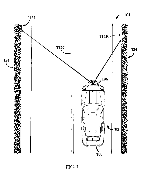
[0019] FIG. 1 provides an illustration of a vehicle on a roadway using the
passive infra-red
guidance system in accordance with an embodiment of the present invention to
determine a
centerline of the travel lane in which the vehicle is travelling.
[0020] FIG. 2 provides a schematic generally illustrating the passive infra-
red guidance system
of FIG. 1.
[0021] FIG. 3 provides a schematic generally illustrating an embodiment of
a centerline
determination method in accordance with the present invention in order to
locate a vehicle on a
roadway using curb line detection.
[0022] FIG. 4 provides a schematic of an alternate embodiment for locating
the vehicle on a
roadway using parallel image processors or algorithms.
[0023] FIG. 5 provides an illustration of a vehicle on a roadway using an
alternate embodiment
of the system in accordance with the present invention to determine a
centerline of the travel lane.
6
CA 03099092 2020-11-02
WO 2019/217037 PCT/US2019/027589
[0024] FIG. 6 provides a schematic generally illustrating the passive infra-
red guidance system
of FIG. 5.
[0025] FIG. 7 provides an illustration of a vehicle on a roadway using the
system in
accordance with an alternate embodiment of the present invention to determine
a path of travel for
the vehicle based on thermal measurement from existing tire tracks of any
preceding vehicle(s).
DETAILED DESCRIPTION OF EMBODIMENTS OF THE INVENTION
[0026] Referring to FIGS. 1-2, a first operational mode of a passive infra-
red guidance
system in accordance with the present invention is illustrated. As illustrated
in FIG. 1, a vehicle
100 generally travels within a travel lane 102 on a roadway 104. The system,
generally
designated by reference numeral 10, comprises at least one forward-looking
passive IR imaging
sensor or sensor array, generally designated as reference numeral 106, mounted
on the vehicle
100 and directed in outwardly front of the vehicle 100 so that it can identify
the edges of the
roadway 104 or travel lane 102. In preferred embodiments of the present
invention, as illustrated
in FIG. 1, a single, forward-looking IR sensor 106 is mounted on the vehicle
100, preferably on
the front of the vehicle 100, and more preferably centered on the vehicle 100
so that it can
measure both the left and right sides of the roadway 104 in front of the
vehicle 100 during travel.
Such a forward-looking IR sensor 106 would generally cover a relatively close
range in front of
the vehicle 100 ¨ about 10 to 20 feet in front of the vehicle 100. Optimally,
the IR sensor 106
has a relatively large pixel array, for example, about 640 x 480 or greater.
[0027] In alternate set-ups of the thermal imaging sensor assembly,
multiple forward-looking
IR sensors 106 can be mounted to the vehicle 100, preferably in over-lapping
and/or redundant
fashion. In an alternate embodiment of the present invention, as illustrated
in FIG. 5, the vehicle
100 may include a dedicated right-side IR sensor 106R ¨ directed toward the
right edge of the
roadway 104/travel lane 102 in a forward-looking manner ¨ and a dedicated left-
side IR sensor
106L ¨ directed toward the left edge of the roadway 104/travel lane 102 in a
forward-looking
manner. In such an embodiment, the sensors 106R and 106L may be positioned on
the front end
of the vehicle 100 or alternately on the lateral sides of the vehicle 100, and
be directed forwardly
from the vehicle 100.
7
CA 03099092 2020-11-02
WO 2019/217037 PCT/US2019/027589
[0028] The following discussion of IR sensors in regards to the present
invention could be a
single sensor or a set of sensors operating to a collective end of detecting
edges of the roadway
104/travel lane 102 through thermal imaging.
[0029] Referring to FIGS. 2 and 6, the IR sensors 106 are in operative
communication with
an image processor 108, such as a video processor, tied into the operational
system of the vehicle
100, such as via a central CAN Bus unit 110. Preferably, the CAN Bus 110 is in
constant
communication with various vehicle sensors, such as the IR sensors 106, for
analysis and output
processing, preferably immediately in real-time, based on the detected data.
In operation, the
system 10 determines the left edge and the right edge of the roadway 104 using
thermal imaging.
More particularly, the image processor 108 analyzes the thermal differences
between a
roadway's surface and areas adjacent to the roadway 104, as well as roadway
features, such as
embedded roadway lane or centerline reflectors, etc., and subsequently creates
a data "picture" of
where a roadway 104 and/or a travel lane 102 exists and ends. Referring to
FIG. 3, the image
processor 108 establishes a left curb line 112L and a right curb line 112R
based on data received
from the IR sensors 106.
[0030] As noted, each IR sensor 106 preferably has a relatively large pixel
array ¨ e.g., about
640 x 480 or greater. In operation, the image processor 108 focuses on a
subset of the pixels
measured by the sensors 106 to identify the left and right edges 112L and 112R
of the roadway
104 or travel lane 102. For example, the image processor 108 can look at the
left 200 pixels or
so to identify the left edge 112L of the roadway 104/travel lane 102 and the
right 200 pixels or so
to identify the right edge 112R of the roadway 104/travel lane 102. Multiple
processors may be
used to analyze the sensor data more quickly and efficiently, and so that both
the left and right
edges 112L and 112R can be analyzed simultaneously.
[0031] In embodiments of the present invention using multiple IR sensors,
such as a
dedicated left and right IR sensor 106L and 106R, respectively, the left and
right curb lines 112L
and 112R will be established based on respective thermal measurements from the
sensors 106L
and 106R. In this regard, a single image processor 108 may be in operative
communication with
each of the left and right IR sensor 106L and 106R, or alternatively, a
dedicated left image
8
CA 03099092 2020-11-02
WO 2019/217037 PCT/US2019/027589
processor and a dedicated right image processor may be used to determine the
left and right curb
lines 112L and 112R, respectively.
[0032] The established curb line information is supplied by the image
processor 108 to the
CAN Bus 110, which establishes the centerline 112C for the roadway 104 or
travel lane 102
depending on the calculated width of the roadway curbs. Upon establishing the
centerline 112C,
and comparing the vehicle's relative position to the calculated centerline
112C, the CAN Bus
110 supplies adjustment instructions to the vehicle operating and guidance
systems, generally
designated as reference numeral 114, if such adjustments are needed.
Appropriate adjustments
can generally include providing direct input to a vehicle's "Driver Assist"
steering system 116,
automatic activation of a vehicle's braking system 118, or adjustment of a
vehicle's propulsion
system 120. The information may also be provided as a data input to the
navigation system of
the autonomous vehicle 100.
[0033] As part of the centerline establishment step, the CAN Bus 110 can
utilize information
from a GPS or navigation system supplied with information about the roadway
104 ¨ such as,
how many lanes the roadway 104 has; which lanes travel in which direction;
whether the vehicle
100 is proximate to or nearing an exit, off ramp, or side street; how large
the shoulder is ¨ in
order to accurately calculate the centerline 112C for a particular roadway 104
or travel lane 102.
In this regard, upon establishment of a left curb line 112L and a right curb
line 112R by the
image processor 108, the CAN Bus 110 can extrapolate the proper position of
the travel lane 102
for the vehicle 100 and the vehicle's relative actual position therein in
order to determine if
adjustments are needed to move the vehicle 100 left or right within the travel
lane 102.
[0034] While generally described herein for use in connection with
autonomous ¨ or
driverless ¨ vehicles, the system 10 of the present invention can also be used
in driven vehicles,
either having a quasi-autonomous mode or as a back-up redundancy to the human
operator. For
example, the centerline information and suggested corrective action may be
provided, for
instance, as a "heads up" display outline 122 on a driven vehicle 100, or as a
video or graphic
"see-through" OLED panel, or other display method, ideally sandwiched between
the layers of
the windshield, or as a data input to the navigation system of the vehicle
100, as illustrated in
FIG. 4. The driver may be able to adjust the vehicle's position and speed
manually, or in the
9
CA 03099092 2020-11-02
WO 2019/217037 PCT/US2019/027589
alternative, the vehicle 100 may automatically adjust the vehicle's position
and speed based on
such continuous monitoring of the vehicle's position. The "see-through" OLED
panel may also
be used to display other vehicle-related information from other vehicle
systems.
[0035] Typical roadway surface materials present a vastly different emitted
thermal
characteristic from that of adjacent non-roadway materials and surfaces, and
thus present a
contrasting thermal picture to an IR sensor 106. For example, during a snow
event, an IR sensor
106 can make ready distinctions between the warmer pavement of the roadway 104
and the
cooler dirt/grass/vegetation 124 situated on the side of the roadway 104.
Alternately, when the
roadway curbing is made of material such as granite that has a greater thermal
mass than the
roadway material, then this type of roadside curbing still thermally contrasts
with the roadway
surface, just in the opposite direction. It is important to note that in
accordance with the present
invention, it does not matter what the absolute thermal reading of any area or
roadway actually
is, but rather the system 10 is looking for thermal boundary differences,
however subtle, to
determine where the roadway edge is located. Of additional note, the image
processor 108 is
continually and dynamically optimizing the thermal contrast range of the
displayed images by
utilizing outside ambient temperature data readings from the CAN Bus 110. When
this
contrasting data is sent and processed by an image processor 108, definitive
roadway edge lines
112L and 112R can be determined and used to further determine a centerline
112C of a roadway
104 or travel lane 102, or sent via a vehicle's CAN Bus 110 to be operatively
connected to a
vehicle's guidance system(s) 114 for autonomous steering, propulsion, and or
braking
adjustment, or, for example, to a heads-up display 122 superimposed on the
windshield of a
vehicle 100 for aiding a human driver.
[0036] Additionally, the application of typically used solid or liquid
melting agents which
are applied either before, during, or after snow/ice conditions will contrast
with and further
enhance the thermal signature of a roadway 104 relative to its adjacent areas
124, and also serve
as a powerful de facto initial "marker trail" for the vehicle 100 to follow
using the system 10 of
the present invention.
[0037] Referring to FIG. 7, an alternate embodiment of the present
invention, especially
useful in difficult road conditions, such as snow- or ice-covered roadways, is
illustrated. FIG. 7
CA 03099092 2020-11-02
WO 2019/217037 PCT/US2019/027589
essentially illustrates what an IR sensor would see, as well as what would be
displayed from the
image processor 108, even though such tire tracks would generally be difficult
or often
impossible to detect in the visible wavelength spectrum as the tracks would
typically be the same
color as adjacent undisturbed snow, ice, or rain. In such an embodiment, the
image processor
108 can supply a vehicle 100 with the ability to identify the ad-hoc "path"
created by a previous
vehicle's travel, or, as noted above, the prior application of melting agents
if there are no prior
tire tracks to create a target centerline of this path for an autonomous
vehicle 100, or to guide a
driver. Intrinsic friction created by the constant flexing of a tire's
sidewalls and tread inherently
creates heat and a subsequent rise in the internal air temperature of a
vehicle's tires, which
transfers through the tire's tread onto a dry, rain-covered, or snow- and/or
ice-covered roadway
surface creating a traceable historic path for a passive IR sensor 106 to
detect. Additionally, the
pressure of a previous vehicle's tires carrying the vehicle's substantial
weight during the
compacting of snow, ice, or rain under the tires creates additional pathway
heating for the IR
sensor 106 to detect.
[0038] As noted, such an embodiment is especially useful when a vehicle 100
is travelling on
a snow-covered road. Traditional active optical visual sensing systems, such
as LIDAR or video
cameras, would have an extremely difficult, if not impossible, time
differentiating shallow tread
depths in the generally monochromatic surface reflectively of a snow-covered
roadway 104. The
system 10 of the present invention, by passively detecting thermal energy
created in the tire
tracks 126, can create an ad hoc centerline in the middle of the previous tire
tracks 126, much as
a human driver does in a roadway that has been travelled on, but not yet
plowed. In the case of
an autonomous vehicle 100, the output generated by the image processor 108 is
sent to the
vehicle's steering system 116 such that appropriate corrections can be made in
the vehicle's
operation. In the case of a driven vehicle 100, guidance information can be
provided on a
Heads-Up display 122 to assist the driver, such as a calculated and/or
suggested ad hoc centerline
projected on the windshield or left/right guidance arrows. With light snow
cover and/or no
recent vehicle travel (such that there are no prior tire tracks to follow),
the system 10 can revert
to measurement of the left and right curb lines 112L and 112R, such as
discussed above.
However, with heavy snow cover and/or recent travel on the roadway 104, such
an alternate
centerline determination method can be used for safe and efficient operation
of the vehicle 100.
11
CA 03099092 2020-11-02
WO 2019/217037 PCT/US2019/027589
Since the system 10 does not utilize visible light wavelengths, its
operational ability is exactly
the same day or night.
[0039] In alternate embodiments of the present invention, existing roadway
markers or
reflectors embedded in the roadway 104 either in the overall roadway
centerline and/or the lane
markers can also provide a contrasting thermal signature easily detected by
the IR sensors 106.
In operation, such thermal markers would exhibit a thermal signature that will
be different from
the surrounding roadway 104. A vehicle 100 can be aware of the general design
of the roadway
104 via the navigation system so that the CAN Bus 110, upon receipt of left
and right edge data
based on measurements of the appropriate markers, can accurately establish a
centerline 112C
for the roadway 104 or a particular travel lane 102, and determine necessary
adjustments
accordingly.
[0040] The system 10 of the present invention is designed to be an adjunct
to other sensors
and guidance systems during times of challenging ambient conditions, and as
such would
enhance an autonomous vehicle's guidance system.
[0041] Unlike many optically-based guidance systems that have diminished
effectiveness at
night, especially in poorly light sections of the roadway 104, the system 10
of the present
invention functions with equal effectiveness day or night, regardless of
lighting conditions.
[0042] The foregoing description of embodiments of the present invention
has been
presented for the purpose of illustration and description. It is not intended
to be exhaustive or to
limit the invention to the form disclosed. Obvious modifications and
variations are possible in
light of the above disclosure. The embodiments described were chosen to best
illustrate the
principles of the invention and practical applications thereof to enable one
of ordinary skill in the
art to utilize the invention in various embodiments and with various
modifications as suited to
the particular use contemplated.
12