Note: Descriptions are shown in the official language in which they were submitted.
CA 03101609 2020-11-25
WO 2019/231464
PCT/US2018/0355/36
1
METHOD, DEVICE AND APPARATUS FOR AUTONOMOUS DOCKING OF
MARINE VESSEL
TECHNICAL HELD
[0001] The present application generally relates to autonomous vessel
maneuvering method, device and apparatus.
BACKGROUND
[0002] This section illustrates useful background information without
admission of
any technique described herein representative of the state of the art.
[0003] The present invention relates to Automated Vessel Maneuvering
System
(AVMS) that is to provide automated vessel maneuvering including automated
docking and undocking.
[0004] Dynamic positioning (DP) is known. It involves automatic or semi-
automatic control of a marine vessel's position and heading by using its own
propellers and thrusters with respect to one or more position references.
Typically,
the intention is to keep the vessel's position fixed within given parameters.
Dynamic
positioning (DP) is utilized e.g. in offshore drilling operations, for
example.
[0005] Autopilots are also known. The autopilot (also known as self-
steering) is an
automatic device or system that guides or maintains a marine vessel's chosen
course
so that constant 'hands-on' control by a human operator is not necessarily
required.
[0006] Automatic radar plotting aid is also known. That can be utilized
in
calculating a tracked object's course, speed and closest point of approach to
detect if
there is a danger of collision with another ship or landmass, for example.
[0007] However, autonomous marine vessel maneuvering from transit to
docking
in safe and efficient way is still needed.
[0008] Thus, a solution is needed to enable accurate, efficient, and
reliable
method for autonomous docking and undocking.
CA 03101609 2020-11-25
WO 2019/231464 PCT/US2018/035586
2
SUMMARY
[0009] Various aspects of examples of the invention are set out in the
claims.
[0010] According to a first example aspect of the present invention,
there is
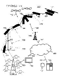
provided a computer-implemented method for autonomous marine vessel docking,
the method comprising:
determining a transit control mode associated with route plan data defining
transit operation between ports;
determining an autonomous docking control mode associated with harbor track
data comprising a set of waypoint properties and defining approach zone
information
and track segments joined at waypoints, wherein the approach zone information
comprises:
location area information for the approach zone;
maximum vessel speed for entering the approach zone; and
maximum heading deviation for entering the approach zone;
determining vessel location, speed and heading;
comparing the vessel location, speed and heading to the approach zone
information and changing from the transit control mode to the autonomous
docking
control mode in response to:
the vessel location comprised by the location area information;
the vessel speed being lower than the maximum vessel speed for entering
the approach zone; and
the vessel heading matching criteria defined by the maximum heading
deviation for entering the approach zone.
[0011] In an embodiment, the method further comprises determining a
dynamic
setpoint based on the waypoint properties, wherein the dynamic setpoint
comprising
a setpoint position, a setpoint speed and a setpoint heading that change based
on
the harbor track data.
[0012] In an embodiment, the method further comprises:
determining difference information between the dynamic setpoint and the
determined vessel location using a closed loop controller;
determining a force vector based on the difference information; and
CA 03101609 2020-11-25
WO 2019/231464 PCT/US2018/035586
3
controlling thruster commands of the autonomous docking control mode based
on the force vector.
[0013] In an embodiment, the method further comprises:
aligning the vessel heading to the setpoint heading and the vessel speed to
the
setpoint speed, wherein the setpoint heading and the setpoint speed are
configurable
parameters.
[0014] In an embodiment, the method further comprises:
interpolating the setpoint heading and the setpoint speed between waypoints
and respective setpoint values based on the marine vessel's location on the
track
segment; and
aligning the vessel heading to the interpolated setpoint heading and the
vessel
speed to the interpolated setpoint speed.
[0015] In an embodiment, interpolating is enabled based on a waypoint
property
of the waypoint to which the marine vessel is heading.
[0016] In an embodiment, the method further comprises:
defining a lower speed threshold and a higher speed threshold; and
determining sway control information based on the dynamic setpoint and the
determined vessel location.
[0017] In an embodiment, the method further comprises:
controlling, in a low speed mode, sway controlling thruster commands of at
least
one thruster of the marine vessel based on the sway control information by
activating
full scale three axis position and heading control by allocating full scale
thrust to the
at least one thruster of the marine vessel, when the marine vessel speed being
less
than the lower speed threshold.
[0018] In an embodiment, the method further comprises:
disabling, in a high-speed mode, sway controlling thruster commands of at
least
one thruster of the marine vessel when the marine vessel speed being greater
than
the higher speed threshold.
[0019] In an embodiment, the method further comprises:
controlling, in an intermediate speed mode, sway controlling thruster commands
of at least one thruster of the marine vessel based on the sway control
information by
CA 03101609 2020-11-25
WO 2019/231464 PCT/US2018/035586
4
activating partial scale three axis position and heading control by allocating
partial
scale thrust to the at least one thruster of the marine vessel, when the
marine vessel
speed being between the lower and higher speed threshold.
[0020] In an embodiment, the partial scale is smaller than the full
scale.
[0021] In an embodiment, in the intermediate speed mode, the partial scale
is
gradually changed between zero and the full scale with respect to the marine
vessel
speed.
[0022] In an embodiment, in the intermediate speed mode, the partial
scale is
gradually increased from zero to the full scale with respect to the marine
vessel
speed decreasing from the higher speed threshold to the lower speed threshold.
[0023] In an embodiment, the method further comprises:
maintaining the harbor track data for a port of call and a berthing position
within
the port, wherein the harbor track data comprises:
approach corridor data defining bounds on maximum track position
deviation allowed during harbor maneuvering; and
the approach zone information.
[0024] In an embodiment, the approach zone information further
comprises
maximum lateral deviation for entering the approach zone, and the method
further
comprises:
comparing the vessel location, speed and heading to the approach zone
information and changing from the transit control mode to the autonomous
docking
control mode in response to:
the vessel deviation is less than the maximum lateral deviation for entering
the approach zone.
[0025] In an embodiment, the method further comprises:
determining entry leg data in response to changing to the autonomous docking
control mode, wherein the entry leg data is configured to guide the marine
vessel
onto a harbor track defined by the harbor track data.
[0026] In an embodiment, in the transit control mode the marine vessel
is
configured to be at least partially in manual control mode.
[0027] In an embodiment, the method further comprises:
CA 03101609 2020-11-25
WO 2019/231464 PCT/US2018/035586
determining alignment of the marine vessel in view of a harbor track using the
harbor track data; and
selecting sail direction based on the determined alignment.
[0028]
According to a second example aspect of the present invention, there is
5 provided a marine vessel apparatus for autonomous docking, comprising:
at least one sensor:
a communication interface for transceiving data;
at least one processor; and
at least one memory including computer program code;
the at least one memory and the computer program code configured to, with the
at least one processor, cause the apparatus to:
determine a transit control mode associated with route plan data defining
transit operation between ports;
determine an autonomous docking control mode associated with harbor
track data comprising a set of waypoint properties and defining approach zone
information and track segments joined at waypoints, wherein the approach zone
information comprises:
location area information for the approach zone;
maximum vessel speed for entering the approach zone; and
maximum heading deviation for entering the approach zone;
determine vessel location, speed and heading;
compare the vessel location, speed and heading to the approach zone
information and changing from the transit control mode to the autonomous
docking
control mode in response to:
the vessel location comprised by the location area information;
the vessel speed being lower than the maximum vessel speed for
entering the approach zone; and
the vessel heading matching criteria defined by the maximum
heading deviation for entering the approach zone.
[0029] In an embodiment, the at least one sensor is configured to provide
position
related data or environment related data.
CA 03101609 2020-11-25
WO 2019/231464 PCT/US2018/035586
6
[0030] In an embodiment, the at least one sensor comprises at least one
of the
following:
a global navigation satellite system (GNSS) position sensor;
a docking sensor for providing relative positioning information relative to a
berth;
a gyro compass sensor for providing heading information;
a motion reference unit (MRU) sensor for providing pitch and roll information;
and
a wind sensor for providing wind speed and wind direction information.
[0031] In an embodiment, the at least one memory and the computer
program
code are further configured to, with the at least one processor, cause the
apparatus
to:
select the global navigation satellite system (GNSS) position sensor as
positioning information source in a first set of the track segments; and
determine vessel distance to the berth and select the docking sensor as
positioning information source in a second set of the track segments in
response to
the vessel distance being less than a pre-defined threshold.
[0032] In an embodiment, the at least one memory and the computer
program
code are further configured to, with the at least one processor, cause the
apparatus
to:
determine a dynamic setpoint based on the waypoint properties, wherein the
dynamic setpoint comprising a setpoint position, setpoint speed and a setpoint
heading that change based on the harbor track data.
[0033] In an embodiment, the at least one memory and the computer
program
code are further configured to, with the at least one processor, cause the
apparatus
to:
determine difference information between the dynamic setpoint and the
determined vessel location using a closed loop controller;
determine a force vector based on the difference information; and
control thruster commands of the autonomous docking control mode based on
the force vector.
[0034] In an embodiment, the apparatus further comprises:
CA 03101609 2020-11-25
WO 2019/231464 PCT/US2018/035586
7
at least one thruster; and
wherein the at least one memory and the computer program code are
configured to, with the at least one processor, cause the apparatus to:
determine external force information;
combine the force vector with the external force information;
determine the thruster commands based on the combination; and
control the at least one thruster based on the thruster commands.
[0035] In an embodiment, the external force information comprises wind
information.
[0036] In an embodiment, the apparatus further comprises:
a plurality of thrusters; and
wherein the at least one memory and the computer program code are further
configured to, with the at least one processor, cause the apparatus to:
control full three axis position and heading by allocating thrust to the
plurality of thrusters
[0037] According to a third example aspect of the present invention,
there is
provided a computer program embodied on a computer readable medium comprising
computer executable program code, which code, when executed by at least one
processor of an apparatus, causes the apparatus to:
determine a transit control mode associated with route plan data defining
transit
operation between ports;
determine an autonomous docking control mode associated with harbor track
data comprising a set of waypoint properties and defining approach zone
information
and track segments joined at waypoints, wherein the approach zone information
comprises:
location area information for the approach zone;
maximum vessel speed for entering the approach zone;
maximum heading deviation for entering the approach zone; and
maximum lateral deviation for entering the approach zone;
determine vessel location, speed and heading;
Attorney Ref.:1531 P001 CA01
8
compare the vessel location, speed and heading to the approach zone
information and changing from the transit control mode to the autonomous
docking
control mode in response to:
the vessel location comprised by the location area information;
the vessel speed being lower than the maximum vessel speed for entering
the approach zone; and
the vessel heading matching criteria defined by the maximum heading
deviation for entering the approach zone.
[0038] Different non-binding example aspects and embodiments of the present
invention have been illustrated in the foregoing. The embodiments in the
foregoing are
used merely to explain selected aspects or steps that may be utilized in
implementations of the present invention. Some embodiments may be presented
only
with reference to certain example aspects of the invention. It should be
appreciated
that corresponding embodiments may apply to other example aspects as well.
[0038a] In another aspect, this document discloses a computer-implemented
method for autonomous marine vessel docking for a marine vessel, the method
comprising: determining a transit control mode associated with route plan data
defining transit operation between ports; determining an autonomous docking
control
mode associated with harbor track data comprising a set of waypoint properties
and
defining approach zone information and track segments joined at waypoints,
wherein
the approach zone information comprises: location area information for an
approach
zone; maximum vessel speed for entering the approach zone; and maximum
heading deviation for entering the approach zone; determining vessel location,
speed and heading; comparing the vessel location, speed and heading to the
approach zone information and changing from the transit control mode to the
autonomous docking control mode in response to: the vessel location comprised
by
the location area information; the vessel speed being lower than the maximum
vessel speed for entering the approach zone; and the vessel heading matching
criteria defined by the maximum heading deviation for entering the approach
zone;
determining a dynamic setpoint based on the waypoint properties, wherein the
dynamic setpoint comprises a setpoint position, a setpoint speed and a
setpoint
heading that changes based on the harbor track data; interpolating the
setpoint
heading and the setpoint speed between waypoints and respective setpoint
values
Date Recue/Date Received 2023-06-30
Attorney Ref.:1531 P001 CA01
8a
based on the vessel location on a track segment; and aligning the vessel
heading to
the interpolated setpoint heading and the vessel speed to the interpolated
setpoint
speed.
[0038b] In another aspect, this document discloses a marine vessel
apparatus
for autonomous docking for a marine vessel, comprising: at least one sensor: a
communication interface for transceiving data; at least one processor; and at
least
one memory including computer program code; the at least one memory and the
computer program code with the at least one processor, configured to cause the
marine vessel apparatus to: determine a transit control mode associated with
route
plan data defining transit operation between ports; determine an autonomous
docking control mode associated with harbor track data comprising a set of
waypoint
properties and defining approach zone information and track segments joined at
waypoints, wherein the approach zone information comprises: location area
information for an approach zone; maximum vessel speed for entering the
approach
zone; and maximum heading deviation for entering the approach zone; determine
vessel location, speed and heading; compare the vessel location, speed and
heading to the approach zone information and changing from the transit control
mode to the autonomous docking control mode in response to: the vessel
location
comprised by the location area information; the vessel speed being lower than
the
maximum vessel speed for entering the approach zone; and the vessel heading
matching criteria defined by the maximum heading deviation for entering the
approach zone; determine a dynamic setpoint based on the waypoint properties,
wherein the dynamic setpoint comprises a setpoint position, a setpoint speed
and a
setpoint heading that changes based on the harbor track data; interpolate the
setpoint heading and the setpoint speed between waypoints and respective
setpoint
values based on the vessel location on a track segment; and align the vessel
heading to the interpolated setpoint heading and the vessel speed to the
interpolated
setpoint speed.
[0038c] In another aspect, this document discloses a computer program
product embodied on a non-transitory computer readable medium comprising
computer executable program code, when executed by at least one processor of
an
apparatus, causes the apparatus to: determine a transit control mode
associated
with route plan data defining transit operation between ports; determine an
Date Recue/Date Received 2023-06-30
Attorney Ref.:1531 P001 CA01
8b
autonomous docking control mode associated with harbor track data comprising a
set of waypoint properties and defining approach zone information and track
segments joined at waypoints, wherein the approach zone information comprises:
location area information for an approach zone; maximum vessel speed for
entering
the approach zone; and maximum heading deviation for entering the approach
zone;
determine vessel location, speed and heading; compare the vessel location,
speed
and heading to the approach zone information and changing from the transit
control
mode to the autonomous docking control mode in response to: the vessel
location
comprised by the location area information; the vessel speed being lower than
the
maximum vessel speed for entering the approach zone; and the vessel heading
matching criteria defined by the maximum heading deviation for entering the
approach zone; determine a dynamic setpoint based on the waypoint properties,
wherein the dynamic setpoint comprises a setpoint position, a setpoint speed
and a
setpoint heading that changes based on the harbor track data; interpolate the
setpoint heading and the setpoint speed between waypoints and respective
setpoint
values based on the vessel location on a track segment; and align the vessel
heading to the interpolated setpoint heading and the vessel speed to the
interpolated
setpoint speed.
[0038d] In a
further aspect, this document discloses a non-transitory, computer
readable medium embodying a computer program comprising computer executable
instructions that, when executed by at least one processor of an apparatus,
causes
the apparatus to: determine a transit control mode associated with route plan
data
defining transit operation between ports; determine an autonomous docking
control
mode associated with harbor track data comprising a set of waypoint properties
and
defining approach zone information and track segments joined at waypoints,
wherein
the approach zone information comprises: location area information for an
approach
zone; maximum vessel speed for entering the approach zone; and maximum
heading deviation for entering the approach zone; determine vessel location,
speed
and heading; compare the vessel location, speed and heading to the approach
zone
information and changing from the transit control mode to the autonomous
docking
control mode in response to: the vessel location comprised by the location
area
information; the vessel speed being lower than the maximum vessel speed for
entering the approach zone; and the vessel heading matching criteria defined
by the
Date Recue/Date Received 2023-06-30
Attorney Ref.:1531 P001 CA01
8c
maximum heading deviation for entering the approach zone; determine a dynamic
setpoint based on the waypoint properties, wherein the dynamic setpoint
comprises
a setpoint position, a setpoint speed and a setpoint heading that changes
based on
the harbor track data; interpolate the setpoint heading and the setpoint speed
between waypoints and respective setpoint values based on the vessel location
on a
track segment; and align the vessel heading to the interpolated setpoint
heading and
the vessel speed to the interpolated setpoint speed.
BRIEF DESCRIPTION OF THE DRAWINGS
[0039] For a more complete understanding of example embodiments of the
present invention, reference is now made to the following descriptions taken
in
connection with the accompanying drawings in which:
[0040] Fig. 1 shows a schematic picture of a system according to an
example
embodiment of the invention;
[0041] Fig. 2 presents an example block diagram of a user apparatus in
which
various embodiments of the invention may be applied;
[0042] Fig. 3 presents an example block diagram of a capturing device in
which various embodiments of the invention may be applied;
[0043] Fig. 4 presents an example block diagram of a server apparatus in
which various embodiments of the invention may be applied;
[0044] Fig. 5 presents an example block diagram of a computer apparatus
in
which various embodiments of the invention may be applied;
[0045] Fig. 6 shows a flow diagram showing operations in accordance with
an
example embodiment of the invention;
Date Recue/Date Received 2023-06-30
CA 03101609 2020-11-25
WO 2019/231464 PCT/US2018/035586
9
[0046] Fig. 7
shows a schematic picture of a control system according to an
example embodiment of the invention, and
[0047] Fig. 8 shows a schematic picture of a closed loop controller
block diagram
according to an example embodiment of the invention.
DETAILED DESCRIPTION OF THE DRAWINGS
[0048] In the following description, like numbers denote like elements.
[0049] Embodiments of the invention relate to Automated Vessel
Maneuvering
System (AVMS) that is to provide automated vessel maneuvering including
automated docking and undocking.
[0060] Building blocks such as sensor processing, guidance and control
logic,
thruster allocation etc. exist for autonomous vessel control. However,
different
embodiments disclosed show technical effects on areas of guidance, controls,
sensor
processing, estimation and thruster allocation, especially when docking or
undocking
autonomously.
[0051] Fig. 1 shows a schematic picture of a system 100 according to an
example
embodiment. A marine vessel 121 may comprise an apparatus 120 comprising
means for generating, processing and transceiving vessel related data, for
example.
The apparatus 120 is capable of downloading and locally executing software
program
code. The software program code may be a client application of a service whose
possible server application is running on a server apparatus 130, 131 of the
system
100. The apparatus 120 may comprise a capturing device, such a sensor device,
for
providing vessel related signals and data. The sensor device may comprise an
accelerometer, an inclinometer, a gyroscope, a wind sensor, a positioning
sensor, a
temperature sensor, a pressure sensor, or a camera, for example. The camera
may
also be used to provide video data and a microphone may be used for providing
audio data, for example. The sensor device may also provide environmental
signals
and data.
[0052] In an embodiment, track follow capability of a marine vessel 121
may be
provided by a High-Speed Track Follow mode (HSTF). In this mode, speed may be
controlled manually while the heading is automatically controlled to maintain
the
CA 03101609 2020-11-25
WO 2019/231464 PCT/US2018/035586
vessel's lateral position relative to the track using rudders or steerable
thrusters. This
mode does not provide direct sway control and may therefore be only suited for
medium to high speed where sway control can be achieved indirectly by
controlling
the heading setpoint for the yaw controller.
5 [0053] For
low speed tracking, a Low Speed Track Follow mode (LSTF) may be
provided, in which direct full three axis position and heading control is
achieved by
allocating thrust to all available thrusters.
[0054]
In an embodiment, the High-Speed Track Follow (HSTF) mode may be
configured to automatically control the vessel speed. The speed command is
defined
10 in the track data and the operator can adjust it up or down within
limits if needed. The
GNSS data may further be used to adjust the thrust command to follow the speed
command.
[0055]
In an embodiment, the Automated Vessel Maneuvering System (AVMS)
includes a further mode, Automated Harbor Maneuvering (AHM), which expands on
the Auto Position and LSTF modes to achieve precision maneuvers for docking
and
undocking.
[0056]
Between ports, the system 100 will be able to follow routes using HSTF.
However, during docking and undocking, the system 100 will operate in AHM mode
to
automatically follow and execute precise maneuvers along a "harbor track" 170.
The
harbor track 170 includes all the necessary information to maneuver the vessel
121
between the docked position and the HSTF route. If the environment or other
constraints so require, the operator can choose between different harbor
tracks 170.
Fig. 1 provides a conceptual illustration of a vessel 121 following a harbor
track 170
to its docked position 171.
[0057] In an embodiment, the Automated Vessel Maneuvering System (AVMS) is
configured to enable automatic blending between LSTF and HSTF behavior. At
intermediate speeds, the marine vessel 121 control may be a combination of the
two,
which provides a smooth transition and allows operation at any speed. For
example,
at low speeds, direct sway control is used. This control is gradually reduced
as the
marine vessel 121 accelerates such that there is no direct sway control at
high
speeds. Such functionality allows the Automated Vessel Maneuvering System
CA 03101609 2020-11-25
WO 2019/231464 PCT/US2018/035586
11
(AVMS) to take the marine vessel 121 from high speeds in open water down to a
stop
at the dock 171.
[0058] The transit operation between ports, and the automated
docking/undocking operation, may be performed using separate modes.
Alternatively,
they may be combined as a single mode.
[0059]
Manual vessel control will involve using the thrust control levers to
manually control vessel speed and heading. Automated vessel control will
involve
switching control of the vessel propulsion and steering to the AVMS. This may
be
accomplished through the use of a bridge installed mechanical two position
switch
within the vessel 121, with one position dedicated to "Manual" control and the
other to
"AVMS" control. Use of a switch ensures that control can always be restored to
the
thrust levers and conning.
[0060]
In an embodiment, a lower speed threshold and a higher speed threshold
may be defined and sway control information determined based on the dynamic
setpoint and the determined vessel location. In a low speed mode, sway
controlling
thruster commands of at least one thruster of the marine vessel are controlled
based
on the sway control information by activating full scale three axis position
and
heading control by allocating full scale thrust to the at least one thruster
of the marine
vessel, when the marine vessel speed being less than the lower speed
threshold. In a
high-speed mode, sway controlling thruster commands of at least one thruster
of the
marine vessel are disabled when the marine vessel speed being greater than the
higher speed threshold. In an intermediate speed mode, sway controlling
thruster
commands of at least one thruster of the marine vessel are controlled based on
the
sway control information by activating partial scale three axis position and
heading
control by allocating partial scale thrust to the at least one thruster of the
marine
vessel, when the marine vessel speed being between the lower and higher speed
threshold. The partial scale is smaller than the full scale and the partial
scale may be
gradually changed between zero and the full scale with respect to the marine
vessel
speed. In the intermediate speed mode, the partial scale may be gradually
increased
from zero to the full scale with respect to the marine vessel speed decreasing
from
the higher speed threshold to the lower speed threshold, for example.
CA 03101609 2020-11-25
WO 2019/231464 PCT/US2018/035586
12
[0061] For vessel 121 transit and docking the AVMS may function in one
of three
possible states, for example: Standby, Docked and Sail.
[0062] When vessel 121 control is initially transferred to the AVMS the
AVMS will
be in the Standby state. In this state the thrusters are set to zero command
allowing
the operator to configure the system. The following operations may be
available in
Standby: Configure system parameters. Sensor selection, Harbor track
selection,
Thruster selection, Thruster checks (automated command/feedback test), and
Monitoring, for example.
0063] From the Standby state the AVMS may transition to either the
Docked or
Sail states depending on the requirements of a particular situation. The AVMS
may
switch back to the Standby state once docked, depending on the requirements
for a
particular berth.
[0064] In an embodiment, when the two-position switch is returned to
the Manual
position the AVMS will return to (or remain in) the Standby state, however in
this case
it will not have any control over the thrusters and steering (thruster checks
will not
function).
[0065] The Docked state covers the case where the AVMS is required to
actively
hold a vessel 121 in a docked position 171 for a period of time. In this state
the AVMS
may automatically (e.g. triggered by a "ramp down" signal) control the
thrusters to
hold the vessel 121 hard against a berth wall while loading and unloading
operations
take place.
[0066] Transition to the Docked state may also be performed manually
since it
needs to happen just prior to contacting the dock. The ramp may not be lowered
until
the marine vessel 121 is safe against the dock 171.
[0067] The Sail state includes all operations involving the following of a
track 170
and the directives contained within one or more waypoints 181 - 187.
[0068] The AVMS is configured to support continuous automated vessel
121
operations involving transit and docking/undocking maneuvers. While the
operation is
automated some user input may be required, both for safety of operation and
also to
provide for operational variances. An example of this might be a transit
operation
where multiple tracks 170 exist due to various environmental conditions, or
for
CA 03101609 2020-11-25
WO 2019/231464 PCT/US2018/035586
13
docking operations where multiple berths are available. For example, a vessel
121
leaving from one port can have a plurality of alternative possible
destinations. In this
case the operator may be required to select the next destination port prior to
the
AVMS completing the undocking operation. During automated operation required
user input may be flagged to the user with visible requests on a Multi-
Function
Display (MFD), and ultimately audible alarms. As a safety measure, should a
required
input not be completed by the operator by the time it is required (such as
berth
selection from the multiple available at the time the vessel 121 is ready to
enter the
Approach Corridor 190) the AVMS will bring the vessel 121 to a stop and hold
station
until further operator input is received. The Multi-Function Display (MFD) may
also be
configured to provide an operator interface. Such interface may comprise a
touch
screen to both display information related to the vessel status and allow the
operator
to start, stop, and adjust the AVMS behavior. The touch screen shows the
vessel
states relative to the track as well as alarms and other status information,
for
example.
[0069] In an embodiment, the marine vessel apparatus 120 is configured
to
maintain the harbor track 170 data for a port of call and a berthing position
within the
port, wherein the harbor track data comprises: approach corridor data 190
defining
bounds on maximum track position deviation allowed during harbor maneuvering;
and
the approach zone 180 information. The approach zone 180 information further
comprises maximum lateral deviation for entering the approach zone 180, and
the
AVMS method further comprising: comparing the vessel location, speed and
heading
to the approach zone information and changing from the transit control mode to
the
autonomous docking control mode in response to the vessel deviation is less
than the
maximum lateral deviation for entering the approach zone 180.
[0070] Furthermore, entry leg data may be determined in response to
changing to
the autonomous docking control mode, wherein the entry leg data is configured
to
guide the marine vessel 121 onto a harbor track 170 defined by the harbor
track data.
In the transit control mode, the marine vessel 121 is configured to be at
least partially
in manual control mode.
CA 03101609 2020-11-25
WO 2019/231464 PCT/US2018/035586
14
[0071]
Alignment of the marine vessel 121 may be determined in view of a harbor
track 170 using the harbor track data and sail direction determined based on
the
determined alignment.
[0072]
In the present description, by vessel are meant any kinds of waterborne
vessels, typically marine vessels. Most typically the vessel is a ferry, a
cargo ship or
large cruise vessel, but the present disclosure is also applicable for yachts,
for
example.
[0073]
The apparatus 120 is configured to be connectable to a public network
150, such as Internet, directly via local connection or via a wireless
communication
network 140 over a wireless connection 122. The wireless connection 122 may
comprise a mobile cellular network, a satellite network or a wireless local
area
network (WLAN), for example The wireless communication network 140 may be
connected to a public data communication network 150, for example the
Internet,
over a data connection 141. The apparatus 120 may be configured to be
connectable
to the public data communication network 150, for example the Internet,
directly over
a data connection that may comprise a fixed or wireless mobile broadband
access.
The wireless communication network 140 may be connected to a server apparatus
130 of the system 100, over a data connection.
[0074]
In an embodiment, the marine vessel apparatus 120 may set up local
connections within the marine vessel 121 with at least one capturing device
and a
computer device. The capturing device, such as a sensor, may be integrated to
the
apparatus 120 or the marine vessel 121, attached to the hull of the marine
vessel 121
and connected to the vessel control system or arranged as separate sensor
device
and connectable to the network 150 over separate connection.
[0075] The apparatus 120 and its client application may allow the apparatus
120
to log into a vessel data service run on a server 130, for example.
[0076]
In an embodiment, real-time interaction may be provided between the
apparatus 120 and the server 130 to collaborate for marine vessel data over a
network 150. Real-time interaction may also be provided between the apparatus
120
and the remote user device 160 to collaborate for marine vessel data over a
network
150, 161.
CA 03101609 2020-11-25
WO 2019/231464 PCT/US2018/035586
[0077] A sensor data item is generated by a sensor device of the marine
vessel
121. Sensor data items may also be transmitted to the server 130. Sensor data
items
may be processed at the apparatus 120 before transmitting or they may be sent
without further processing.
5 [0078] Sensor data may also be stored within the apparatus 120 before
transmission over the network 150. Then again, transmitted sensor data may be
stored/and or processed at the server apparatus 130 or at the remote user
device
160.
[0079] The apparatus 120 may be connected to a plurality of different
capturing
10 devices and instruments and the apparatus 120 may be configured to select
which
sensor devices is actively collaborated with.
[0080] A user/operator of the apparatus 120 or the remote user device
160 may
need to be logged in with user credentials to a chosen service of the network
server
130.
15 [0081] In an embodiment, the system 100 comprises a sensor device
configured
to be comprised by or connectable to the apparatus 120 over a local
connection. The
local connection may comprise a wired connection or a wireless connection. The
wired interface may comprise such as universal serial bus (USB) or National
Marine
Electronics Association (NMEA) 0183/2000 standard for example. The wireless
connection may comprise acoustic connection, BluetoothTM, Radio Frequency
Identification (RF-ID) or wireless local area network (WLAN), for example.
Near field
communication (NFC) may also be used for sensor device identification between
the
sensor device and the apparatus 120, for example.
[0082] In an embodiment, the system 100 may comprise a server apparatus
130,
which comprises a storage device 131 for storing service data, service metrics
and
subscriber information, over data connection 151. The service data may
comprise
AVMS related data; waypoint properties related data, vessel related data;
environmental data, configuration data; account creation data; sensor data;
sensor
ID's; reference data items, user input data; real-time collaboration data;
predefined
settings; and attribute data, for example.
CA 03101609 2020-11-25
WO 2019/231464 PCT/US2018/035586
16
[0083] In an embodiment, a proprietary application in the apparatus 120
may be a
client application of a service whose server application is running on the
server
apparatus 130 of the system 100.
[0084] The proprietary application of the apparatus 120 may receive
sensor input
data and provide the output data. The input data may comprise data captured by
the
capturing device, such as a sensor device or a camera.
0085] In an embodiment, configuration information or application
download
information for any apparatus may be automatically downloaded and configured
by
the server 130. Thus, the user of the devices may not need to do any
initialization or
configuration for the service. The system server 130 may also take care of
account
creation process for the service, such sensor devices, apparatuses and users.
Timing
of the download may also be configured to be automatic and optimized in view
of the
vessel travel plan. For example, download may be automatically taking place
when
the marine vessel is docked at harbor.
0086] In an embodiment, the association of the devices can be one-time or
stored persistently on any of the devices or the server 130.
[0087] In an embodiment, authentication of a sensor device or apparatus
120 on
a system server 130 may utilize hardware or SIM credentials, such as
International
Mobile Equipment Identity (IMB) or International Mobile Subscriber Identity
(lMS!).
The sensor device or apparatus 120 may transmit authentication information
comprising IMEI and/or IMSI, for example, to the system server 130. The system
server 130 authenticates the device by comparing the received authentication
information to authentication information of registered users I devices /
vessels /
apparatuses stored at the system server database 131, for example. Such
authentication information may be used for pairing the devices and/or
apparatuses to
generate association between them for a vessel data connection.
[0088] In an embodiment, a service web application may be used for
configuration
of a system. The service web application may be run on any user device, admin
device, or a remote control device 160, such as a personal computer connected
to a
public data network, such as Internet 150, for example. The control apparatus
160
may also be connected locally to the apparatus 120 over a local connection 123
and
CA 03101609 2020-11-25
WO 2019/231464 PCT/US2018/035586
17
may utilize the network connections of the apparatus 120 for configuration
purposes.
The service web application of the control apparatus may provide
searching/adding
instruments, determining attributes, device setup and configuration, for
example. The
service web application of the control apparatus 160 may be a general
configuration
tool for tasks being too complex to be performed on the user interface of the
apparatus 120, for example.
[0089] In an embodiment, a remote control apparatus 160 may be
authenticated
and configuration data sent from the control apparatus 160 to the system
server 130,
131, wherein configuration settings may be modified based on the received
data. In
an embodiment, the modified settings may then be sent to the apparatus 120
over
the network 150 and the local connection or the wireless operator. The
modified
settings may also be sent to external devices correspondingly, through the
apparatus
120 or directly over the network 150, for example.
[0090] In an embodiment, the sensor device may be wireless or wired.
[0091] The system 100 may also comprise a plurality of satellites 110 in
orbit
about the Earth. The orbit of each satellite 110 is not necessarily
synchronous with
the orbits of other satellites and, in fact, is likely asynchronous. A global
positioning
system receiver apparatus such as the ones described in connection with
preferred
embodiments of the present invention is shown receiving spread spectrum Global
Navigation Satellite System global positioning system (GNSS) satellite signals
112
from the various satellites 110.
[0092] The remote control apparatus 160 may be configured to be
operated by a
remote operator of the vessel 121. The remote control apparatus 160 may be
arranged on a ground station, on the vessel 121 or on another vessel, for
example.
[0093] In an embodiment, starting automated operations may comprise
engaging
the AVMS followed by activating the "Sail" on the Multi-Function Display
(MFD),
which will transition the AVMS into the Sail mode. It is required that the
AVMS is
configured correctly prior to activating "Sail", else the AVMS will not
transition into the
Sail mode.
[0094] Configuration of the AVMS requires that sufficient sensors are
online and
selected, that sufficient thrusters are online and selected, and that a track
170 and
CA 03101609 2020-11-25
WO 2019/231464 PCT/US2018/035586
18
destination 171 have been selected. Depending on the location of the vessel
121
(docked, or in transit under conning control) the operator may have to select
from
multiple tracks 170 in a track library, or may have to move close to a
waypoint 180-
187 on the selected track 170 prior to activating the "Sail" mode.
[0095] In an embodiment, the Automated Vessel Maneuvering System (AVMS) is
configured to support double-ended vessels. The Automated Vessel Maneuvering
System (AVMS) is configured to automatically pick the sail direction based on
how
the vessel 121 is aligned with the track 170 when AVMS is initiated.
0096] In an embodiment, for the operator, automated maneuvering
between
ports will be a seamless operation starting after the loading ramp is raised
and the
vessel 121 is ready to undock, and ending when the vessel 121 is in position
at a
berth in the next port of call and is ready to lower the loading ramp. The
automated
maneuvering operation may be divided into 3 phases: Transit, Docking, and
Undocking, as defined in the following paragraphs.
[0097] In an embodiment, the marine vessel apparatus 120 is configured to
determine a dynamic setpoint based on the waypoint properties, wherein the
dynamic
setpoint comprising a setpoint position, a setpoint speed and a setpoint
heading that
change based on the harbor track data. Furthermore, difference information may
be
detem-iined between the dynamic setpoint and the determined vessel location
using a
.. closed loop controller, a force vector determined based on the difference
information;
and thruster commands of the autonomous docking control mode controlled based
on
the force vector.
[0098] In an embodiment, the vessel heading may be aligned to the
setpoint
heading and the vessel speed to the setpoint speed, wherein the setpoint
heading
and the setpoint speed are configurable parameters.
[0099] Furthermore, the setpoint heading and the setpoint speed between
waypoints and respective setpoint values may be interpolated based on the
marine
vessel's location on the track segment, and the vessel heading aligned to the
interpolated setpoint heading and the vessel speed to the interpolated
setpoint
speed. Interpolating may be enabled based on a waypoint property of the
waypoint to
which the marine vessel is heading.
CA 03101609 2020-11-25
WO 2019/231464 PCT/US2018/035586
19
Docking
[00100] The AVMS will contain a pre-planned Harbor track 170 for each port of
call, and each berthing position 171 within the port, which can be followed
from the
harbor entry zone 180 to the berth 171 for the purposes of auto-docking. This
track
170 will include an approach corridor 190 which sets bounds on the maximum
track
position deviation allowed during harbor maneuvering and includes an entry
zone 180
that is used when transitioning into the Docking phase. Harbor track 170 data
is
stored within the marine vessel apparatus 120 for operation of the AVMS and
comprises all necessary data for AVMS, such as data relating to the Harbor
track
170, the berthing position 171 the waypoints 181-187, the harbor entry zone
180,
and the approach corridor 190, for example.
[00101] There are some scenarios that must be considered. One scenario covers
the case that the vessel 121 is transitioning from an autonomous transit to
the
Docking phase, and a second scenario covers the case that the vessel 121 is in
manual mode (operator performed a manual transit using the conning) and is
transitioning to the (autonomous) Docking phase. For both cases the vessel 121
must
be positioned within the approach zone 180, and must meet required pre-
requisite
conditions, to be permitted to transition into the Docking phase.
[00102] The pre-requisite conditions for transition to the Docking phase may
comprise, for example:
a. Vessel speed must be less than the maximum specified by the
approach corridor way points 181-187
b. Heading deviation must be less than the maximum specified by the
approach corridor 190 waypoints 181-187
c. Lateral deviation must be less than the approach corridor 190 width
d. Heading and lateral deviations will be checked together. A larger
heading deviation can be accepted if the vessel 121 is steering towards
the Harbor track 170 as opposed to steering away from the track 170.
[00103] Once the vessel 121 is positioned within the Approach zone 180, and
meets the pre-requisite conditions (see above), an "entry leg" is
automatically
CA 03101609 2020-11-25
WO 2019/231464 PCT/US2018/035586
calculated which is used by the AVMS to autonomously guide the vessel 121 onto
the
Harbor track 170. At this point the Docking phase has started and the AVMS
will
proceed to maneuver the vessel 121 to the dock 171 using the pre-programmed
speed and steps specified in the Harbor track 170 data.
5 [00104] During the initial approach, the marine vessel apparatus 120 may
use
GNSS 110 for positioning. Once the vessel 121 reaches the proximity of the
specified
berth 171, the system may automatically start tracking the vessel's 121
position and
heading relative to the berth 171. During the final approach, the marine
vessel
apparatus 120 may use relative positioning (docking sensor) to allow greater
10 precision during docking. The transition between absolute and relative
positioning
may be automatically handled in a bump less fashion by the AVMS.
[00105] The end of the Docking phase is reached when the vessel 121 has
reached the final waypoint 187, is berthed at position 171 and ready to lower
the
loading ramp, for example. The behavior at the endpoint 171 of the Harbor
track 170
15 may be configurable in the final waypoint 187 properties from the
following options,
for example: Hold Station (this is the same as station keeping), Transition to
the
Standby state (switch back to manual control), and Transition to the Docked
state.
[00106] In all cases, except Hold Station, it may be necessary to transition
out of
the Docking phase (Sail state) prior to lowering the loading ramp as the
vessel 121
20 position should be secured prior to deploying the ramp.
[00107] Separately there may be an option for the AVMS to save particular
parameters which will be required during a subsequent Undocking phase (this
primarily pertains to the "integrals" which form a dynamic component of the
closed
loop controller).
[00108] In an embodiment, to continue with autonomous operation while berthed,
the AVMS can be configured to automatically use the vessel thrusters to hold
the
vessel 121 against the dock 171 using information contained in the final
waypoint 187
properties. In this case when the vessel 121 has completed the Docking phase
it will
automatically transition to the Docked state and the thrusters will ramp up to
push the
vessel against the dock.
CA 03101609 2020-11-25
WO 2019/231464 PCT/US2018/035586
21
Undockinq
[00109] Undocking is basically the opposite procedure to Docking. For the
vessel
121 to enter the Undocking phase a new destination (and possibly track
(associated
with track data), if several are available) must be selected, the loading ramp
must be
up, and the operator must confirm that the vessel 121 is clear to undock. Once
a
destination and track (with track data) have been selected and the loading
ramp is
raised a confirmation request message may appear on the MFD. The operator may
be required to confirm the clear to undock request for the AVMS to transition
to the
Undocking phase and begin the departure from the berth 171. Once confirmed,
the
AVMS will proceed to maneuver the vessel 121 away from the dock using the pre-
programmed speed, and steps contained in the track data.
[00110] As for the Docking phase the AVMS may utilize a departure track, a
departure corridor, and an exit zone to guide the vessel 121 out of the harbor
area. In
the majority of cases these will be identical to the track 170, corridor 190,
and zone
180 used for harbor entry. The departure track will terminate in the exit
zone.
Transit
[00111] Autonomous maneuvering of the vessel 121 from the final Harbor track
waypoint in the exit zone, and the first Harbor track waypoint 181 in the
entry zone
180 for the next port is referred to as the Transit phase. In this phase the
AVMS will
follow a transit track using information contained within the waypoints
included in the
track data to control vessel speed and heading.
[00112] Transition between the Transit phase and the Docking/Undocking phases
is configured to be bump less. During these transitions the AVMS will be
transitioning
between High Speed Track Follow mode (HSTF) and Low Speed Track Follow mode
(LSTF) gradually with speed, however this transition may be transparent to the
operator.
[00113] During the docking and undocking phases, the system will operate in
Automated Harbor Maneuvering (AHM) mode to automatically follow and execute
precise maneuvers along the Harbor track 170. The Harbor track 170 data
includes
CA 03101609 2020-11-25
WO 2019/231464 PCT/US2018/035586
22
all the necessary information to maneuver the vessel between the docked
position
171 and the entry/exit zone 180.
[00114] Harbor tracks 170 may comprise straight line segments (legs) joined at
waypoints 181-187 with independent predefined turning radii for the purpose of
precision maneuvering inside the harbor and close to the berth 171. Due to the
precise maneuvering requirements inside the harbor and close to the berth, the
harbor track 170 will include a comprehensive set of waypoint properties,
which will
not only help to guide the vessel 121 but also control the behavior of the
control
system along the track 170. Table below lists some waypoint properties that
may be
used for the harbor track 170 purposes.
Waypoint properties Description
Lat/Lon Absolute waypoint position
Radius Waypoint Turning radius
Corridor width Allowed lateral distance centered over the
waypoint in which the vessel can sail
Track setpoint speed Target setpoint speed
Track setpoint acceleration Target setpoint acceleration
Heading setpoint (along track, Target setpoint heading
fixed)
Heading setpoint ROT Target setpoint Rate of Turn
Advance turn Distance in meters prior to the waypoint
upon
which the heading change will be executed
Track Direction (ahead, astern)
COR Center of rotation ¨see yaw pivot point
Controller mode To set the control strategy based on
position
along the track
Controller gains Controller gains in surge, sway, yaw, cross
track
TAL mode To set the thruster allocation logic based
on
position along the track
Cross track alarm threshold Alarm threshold for cross track position
error
Alongship alarm threshold Alarm threshold for along track position
error
Heading alarm threshold Alarm threshold for heading error
Auto sensor select To automatically enable sensors based on
position along the track
CA 03101609 2020-11-25
WO 2019/231464 PCT/US2018/035586
23
Max speed threshold Max speed allowed to engage the mode
(alongshipi athwartship)
Max Hdg deviation threshold Maximum allowed heading deviation to engage
the mode
Thrust to dock If enabled, and at the last waypoint on the
track,
the system will command thrust against the
dock to keep the vessel in position
Freeze integral If enabled, and at the last waypoint on the
track,
the controller integral will be frozen to prevent
integral windup when in the docked position
Confirm to proceed If enabled, a confirmation dialog will be
displayed for pre-defined time prior to the
waypoint is reached. If not confirmed, the
system will stop the vessel at the waypoint.
VVaypoint with this property set, will have a
conspicuous appearance on the display
Interpolate speed If enabled, the speed setpoint will be
interpolated between values of the From and To
waypoints. If disabled, the speed setpoint will
be set to the value of the From waypoint's.
Interpolate heading If enabled, the heading setpoint will be
interpolated between the values of the From and
To waypoints. If disabled, the speed setpoint
will be set to the value of the From waypoint's.
[00115] When following a Harbor track 170, a plurality of actions and
parameters
may be needed. Following features are exemplary only and not necessarily all
features are needed.
Adjusting the speed
[00116] The default setpoint speed for AHM mode is pre-programmed into the
Harbor track 170 data using a waypoint 181-187. The operator can override
(reduce)
the setpoint speed by using an MFD onscreen control scaled between 0 and 100%,
for example.
CA 03101609 2020-11-25
WO 2019/231464 PCT/US2018/035586
24
001171 In an embodiment, the operator can adjust the speed in increments of
0.5
knots, for example. The speed may be increased or decreased as long as it
remains
within the defined track limits.
Stopping
[00118] While in AHM mode, the operator can stop the vessel 121 on the track
at
any time by activating the MFD "Current Position" function. This will bring
the vessel
121 to a stop on the track 170 by following a specified deceleration profile.
During
the deceleration, the "Current Position" function may be indicated on user
interface to
indicate that deceleration is in progress. If the operator activates the
"Current
Position" function a second time while it is already in process, the setpoint
will come
to an immediate stop. Both actions described above may require an MFD onscreen
confirmation to prevent inadvertent action. While the vessel 121 is stopping,
or
stopped, a "Continue" function will be enabled. By activating the "Continue"
function
it will continue to execute the maneuvering steps defined in the Harbor track
170
data.
Track offsets
[00119] While in AHM mode, the operator can adjust the vessel's 121 lateral
position relative to the track 170, for example, by using MFD on-screen "port"
and
"starboard" offset functions. Each time a function is activated, the lateral
offset will be
incremented in the direction of the activated function (e.g. touch based
button or icon
on touch display). The offsets may be numerically and graphically displayed on
the
MFD overview display. In addition, the offset track line may be displayed
relative to
the default track. The offset will be limited by the corridor 190 width of the
Harbor
track 170 at the position of the setpoint. If the operator tries to place the
offset outside
the corridor 190, a warning may be displayed on the MFD. If the corridor 190
width is
reduced as the vessel 121 is moving along the track 170, the track offsets
will be
automatically reduced to keep the vessel 121 safely inside the corridor 190.
An offset
reset function will be provided to allow the operator to remove offsets in a
single step.
CA 03101609 2020-11-25
WO 2019/231464 PCT/US2018/035586
Track Control
[00120] During high speed tracking, the vessel 121 may follow the heading of
the
track 170 with the necessary heading adjustments to maintain zero cross track
error.
The heading adjustments will be made using the high-speed steering allocation
(e.g.
5 rudders or main azimuth thrusters).
[00121] During low speed tracking, the vessel 121 can optionally align its
heading
to a pre-programmed setpoint heading. This allows the vessel 121 to perform
crabbing maneuvers during the approach. Heading and speed setpoints are
configurable waypoint 181-187 properties. Between waypoints 181-187, the speed
10 and heading setpoints may be interpolated based on the vessel's 121
location on the
track 170. The interpolation option is configurable by a waypoint property of
the
waypoint 181-187 to which the vessel 121 is heading.
[00122] The yaw pivot point is the point on the vessel's 121 centerline which
appears to be the center of rotation to an on-board observer. The lateral sway
15 velocity at the point is by definition zero. This is important because
that means that if
the pivot point is used as the control point, sway control force is not needed
to be
used while turning. The location of a vessel's 121 yaw pivot point may depend
on the
vessel's turn rate and lateral velocity.
[00123] In an embodiment, prior to engaging automatic maneuvering, it is
20 necessary to verify that all necessary thrusters are fully operational.
Since thrusters
may not have been in use for extended periods of time, a thruster ready
indication
may not be sufficient to guarantee the operation of the thruster. For this
purpose, an
automated thruster check function is used that automatically issues a command
and
verifies that the thruster is following as expected. Successful thruster
checks
25 immediately prior to engaging AHM, can be included as a condition for
system
readiness.
[00124] In an embodiment, a control mode of the marine vessel 121 is
determined
from track properties (track data) and vessel speed, for example. Difference
information between the dynamic setpoint and the determined vessel location
may
then be determined using a closed loop controller and a force vector
determined
CA 03101609 2020-11-25
WO 2019/231464 PCT/US2018/035586
26
based on the difference information. Thruster commands are determined from the
control mode and the force vector.
[00125] Furthermore, external force information may be determined by the
apparatus 120, the force vector may be then combined with the external force
information, and the thruster commands determined based on the combination. At
least one thruster may be controlled based on the thruster commands. The
external
force information may comprise e.g. wind information that is detected using a
capturing device (e.g. wind sensor), for example.
[00126] Fig. 2 presents an example block diagram of a marine vessel apparatus
120 in which various embodiments of the invention may be applied. The marine
vessel apparatus 120 is configured to operate for autonomous docking.
[00127] The general structure of the marine vessel apparatus 120 comprises a
user interface 240, a communication interface 250, a satellite positioning
device
(GNSS) 270, a capturing device 260 for capturing current vessel activity data
and
current environmental data, a processor 210, and a memory 220 coupled to the
processor 210. The marine vessel apparatus 120 further comprises software 230
stored in the memory 220 and operable to be loaded into and executed in the
processor 210. The software 230 may comprise one or more software modules and
can be in the form of a computer program product. The marine vessel apparatus
120
may further comprise a user interface controller 280.
[00128] The processor 210 may be, e.g., a central processing unit (CPU), a
microprocessor, a digital signal processor (DSP), a graphics processing unit,
or the
like. Fig. 2 shows one processor 210, but the apparatus 120 may comprise a
plurality
of processors.
[00129] The memory 220 may be for example a non-volatile or a volatile memory,
such as a read-only memory (ROM), a programmable read-only memory (PROM),
erasable programmable read-only memory (EPROM), a random-access memory
(RAM), a flash memory, a data disk, an optical storage, a magnetic storage, a
smart
card, or the like. The apparatus 120 may comprise a plurality of memories. The
memory 220 may be constructed as a part of the apparatus 120 or it may be
inserted
into a slot, port, or the like of the user apparatus 120 by a user. The memory
220 may
CA 03101609 2020-11-25
WO 2019/231464 PCT/US2018/035586
27
serve the sole purpose of storing data, or it may be constructed as a part of
an
apparatus serving other purposes, such as processing data. A proprietary
autonomous marine vessel docking application; track data, autonomous vessel
mode
related data, sensor data, vessel related data or environmental data may be
stored to
the memory 220.
[00130] In an embodiment, the apparatus 120 is configured to perform a
computer-
implemented method for autonomous marine vessel docking, the method comprising
determining a transit control mode associated with route plan data defining
transit
operation between ports; determining an autonomous docking control mode
associated with harbor track data comprising a set of waypoint properties and
defining approach zone information and track segments joined at waypoints. The
approach zone information comprises location area information for the approach
zone; maximum vessel speed for entering the approach zone; and maximum heading
deviation for entering the approach zone. The method further comprises
determining
vessel location, speed and heading; comparing the vessel location, speed and
heading to the approach zone information and changing from the transit control
mode
to the autonomous docking control mode in response to: the vessel location
comprised by the location area information; the vessel speed being lower than
the
maximum vessel speed for entering the approach zone; and the vessel heading
matching criteria defined by the maximum heading deviation for entering the
approach zone.
[00131] The user interface controller 280 or the user interface 240 may
comprise
circuitry for receiving input from a user of the marine vessel apparatus 120,
e.g., via a
keyboard, graphical user interface shown on the display of the user interfaces
240 of
the marine vessel apparatus 120, speech recognition circuitry, or an accessory
device, such as a headset, and for providing output to the user via, e.g., a
graphical
user interface or a loudspeaker.
[00132] The Global Navigation Satellite System (GNSS, such as GPS) device 270
is configured to provide location information. Such information may comprise,
for
example, position coordinates, speed, direction of movement; and flute height
information.
CA 03101609 2020-11-25
WO 2019/231464 PCT/US2018/035586
28
[00133] The communication interface module 250 implements at least part of
data
transmission. The communication interface module 250 may comprise, e.g., a
wireless or a wired interface module. The wireless interface may comprise such
as a
WLAN, Bluetooth, infrared (IR), radio frequency identification (RF ID),
GSM/GPRS,
CDMA, WCDMA, LTE (Long Term Evolution) or 5G radio module. The wired interface
may comprise such as universal serial bus (USB) or National Marine Electronics
Association (NMEA) 0183/2000 standard for example. The communication interface
module 250 may be integrated into the marine vessel apparatus 120, or into an
adapter, card or the like that may be inserted into a suitable slot or port of
the marine
vessel apparatus 120. The communication interface module 250 may support one
radio interface technology or a plurality of technologies. The marine vessel
apparatus
120 may comprise a plurality of communication interface modules 250.
[00134] A skilled person appreciates that in addition to the elements shown in
Fig.
2, the marine vessel apparatus 120 may comprise other elements, such as
microphones, extra displays, as well as additional circuitry such as
input/output (I/O)
circuitry, memory chips, application-specific integrated circuits (ASIC),
processing
circuitry for specific purposes such as source coding/decoding circuitry,
channel
coding/decoding circuitry, ciphering/deciphering circuitry, and the like.
Additionally,
the marine vessel apparatus 120 may comprise a disposable or rechargeable
battery
(not shown) for powering when external power if external power supply is not
available.
[00135] In an embodiment, the marine vessel apparatus 120 comprises speech
recognition means. Using these means, a pre-defined phrase may be recognized
from the speech and translated into control information for the apparatus 120,
for
example.
[001361 The satellite positioning device 270 and the capturing device 260 may
be
configured to be comprised by the marine vessel apparatus 120 or connected as
separate devices to the apparatus 120. In case the satellite positioning
device 270
and the capturing device 260 are comprised in the apparatus 120 they may be
connected to the apparatus 120 using an internal bus of the apparatus 120. In
case
the satellite positioning device 270 and the capturing device 260 are external
devices
CA 03101609 2020-11-25
WO 2019/231464 PCT/US2018/035586
29
connected to the apparatus 120 they may be connected to the apparatus 120
using
communication interface 250 of the apparatus 120 or using a connection to the
internal bus.
[00137] In an embodiment, the capturing device 260 may comprise a global
navigation satellite system (GNSS) position sensor and a docking sensor. The
marine
vessel apparatus 120 is configured to select the global navigation satellite
system
(GNSS) position sensor as positioning information source in a first set of the
track
segments, determine vessel distance to the berth, and select the docking
sensor as
positioning information source in a second set of the track segments in
response to
the vessel distance being less than a pre-defined threshold.
[00138] Fig. 3 presents an example block diagram of a capturing device 260,
such
as a sensor or sensor device, in which various embodiments of the invention
may be
applied. The capturing device 260 may comprise various means for activity data
detection and environmental data detection, for example. The capturing device
260
may be used for both reference data and current data capturing.
[00139] In an embodiment, the capturing device 260 may comprise at least one
of
the following devices:
- an anemometer for providing wind information;
- a wind sensor for providing wind information;
- a sensor for providing flute height information;
- a barometer for measuring air pressure;
- a temperature sensor for measuring environmental temperature;
- a water depth sensor for measuring depth information;
- a chart plotter for providing position information;
- a sail sensor for providing sail information;
- a speed sensor for providing speed information;
- a video camera for providing a video signal;
- a gyro compass for providing direction information;
- GNSS device, i.e. absolute position sensor based on satellite navigation
(GLONASS, GPS, GALILEO); and
- a motion reference unit (MR U) sensor, i.e. pitch and roll sensor.
CA 03101609 2020-11-25
WO 2019/231464
PCT/US2018/0355/36
[00140] In an embodiment, the marine vessel apparatus 120 may include a suite
of
sensors 260 that will provide position and environment data to support the
controller
operation. GNSS sensor comprises as absolute position sensor based on
satellite
navigation (GLONASS, GPS, GALILEO) that provides the current measured position
5 of the vessel on the earth's surface. The GNSS system that may be used, for
example, is Fugro OceanStarTM 3 that offers decimeter accuracy for position
measurements with a combination of three GNSS receivers. Data is also
available
from individual receivers as a backup position measurement method, though with
less
available accuracy. Gyro Compass comprises an absolute heading sensor that
10 provides the measured offset of the vessel from true north. The motion
reference unit
(MRU) sensor comprises a pitch and roll sensor that provides measured offset
from
the vertical for pitch and roll. The GNSS system may include its own captive
motion
reference unit (MRU). This may be required to increase accuracy of the GNSS
since
the GNSS antenna can swing through a large arc during pitch and roll.
Mathematical
15 calculation can be used to normalize the measurement to the vertical based
on the
pitch and roll measurement.
[00141] The capturing device 260 may also comprise several capturing devices
260, combinations of any above-mentioned devices, and the like. The
environmental
temperature may comprise air temperature, water temperature or ground surface
20 temperature, for example
[00142] In an embodiment, a wind sensor 260 is configured to determine or
measure wind angle and wind speed. The wind sensor 260 may comprise any
element of combination of elements operable to sense wind-related information
for
use by the user apparatus 120. For example. the wind sensor 260 may be
operable
25 to sense apparent wind speed, apparent wind angle, true wind speed, true
wind
angle, wind velocity made good (VMG), combinations thereof, and the like.
[00143] In an embodiment, a sail sensor 260 is configured to determine sail
information. The sail information provides status of the currently used sails
in a boat
and timing of their changes. The sail sensor 260 may comprise a first sensor
in a
30 mast of the boat and a second sensor in the sail to identify which sail
is used in the
mast. Based on the information received from these sensors the user apparatus
120
CA 03101609 2020-11-25
WO 2019/231464 PCT/US2018/035586
31
may define which sails are used in which masts and the times of changing the
sails.
The sail information may be thus used as a part of the reference activity data
and
current activity data. Sail may also comprise rotor sail or other similar
mechanical sail
system.
[00144] In an embodiment, a video camera 260 is configured to provide video
signal. Based on the video signal the marine vessel apparatus 120 may
determine at
least part of the environmental data or object information around the marine
vessel
121. For example, flute height may be determined based on the video signal
from the
video camera 260. The determination may be done by video image processing,
pattern recognition, measuring a rocking movement or relative movement of a
horizon, for example.
[00145] The capturing device 260 may comprise communication interface module
implementing at least part of data transmission. The communication interface
module
may comprise, e.g., a wireless or a wired interface module. The wireless
interface
may comprise such as a WLAN, Bluetooth, infrared (IR), radio frequency
identification
(RF ID), GSM/GPRS, CDMA, WCDMA, LTE (Long Term Evolution) or 5G radio
module. The wired interface may comprise such as universal serial bus (USB) or
National Marine Electronics Association (NMEA) 0183/2000 standard for example.
The communication interface module may be integrated into the capturing device
260, or into an adapter, card or the like that may be inserted into a suitable
slot or
port of the capturing device 260. The communication interface module may
support
one radio interface technology or a plurality of technologies. The capturing
device
260 may comprise a plurality of communication interface modules.
[00146] Fig. 4 presents an example block diagram of a server apparatus 130 in
which various embodiments of the invention may be applied.
00147] The general structure of the server apparatus 130 comprises a processor
410, and a memory 420 coupled to the processor 410. The server apparatus 130
further comprises software 430 stored in the memory 420 and operable to be
loaded
into and executed in the processor 410. The software 430 may comprise one or
more
software modules and can be in the form of a computer program product.
CA 03101609 2020-11-25
WO 2019/231464 PCT/US2018/035586
32
[00148] The processor 410 may be, e.g., a central processing unit (CPU), a
microprocessor, a digital signal processor (DSP), a graphics processing unit,
or the
like. Fig. 4 shows one processor 410, but the server apparatus 130 may
comprise a
plurality of processors.
[00149] The memory 420 may be for example a non-volatile or a volatile memory,
such as a read-only memory (ROM), a programmable read-only memory (PROM),
erasable programmable read-only memory (EPROM), a random-access memory
(RAM), a flash memory, a data disk, an optical storage, a magnetic storage, a
smart
card, or the like. The server apparatus 130 may comprise a plurality of
memories.
The memory 420 may be constructed as a part of the server apparatus 130 or it
may
be inserted into a slot, port, or the like of the server apparatus 130 by a
user. The
memory 420 may serve the sole purpose of storing data, or it may be
constructed as
a part of an apparatus serving other purposes, such as processing data.
[00150] The communication interface module 450 implements at least part of
radio
transmission. The communication interface module 450 may comprise, e.g., a
wireless or a wired interface module. The wireless interface may comprise such
as a
WLAN, Bluetooth, infrared (IR), radio frequency identification (RF ID),
GSM/GPRS,
CDMA, WCDMA, LTE (Long Term Evolution) or 5G radio module. The wired interface
may comprise such as universal serial bus (USB) or National Marine Electronics
Association (NMEA) 0183/2000 standard for example. The communication interface
module 450 may be integrated into the server apparatus 130, or into an
adapter, card
or the like that may be inserted into a suitable slot or port of the server
apparatus 130.
The communication interface module 450 may support one radio interface
technology
or a plurality of technologies. Captured autonomous docking related data,
track data,
vessel activity data associated or environmental data of the marine vessel
apparatus
120 may be received by the server apparatus 130 using the communication
interface
450. Data may be stored for backup or processed and provided to a marine
vessel
apparatus. The data may be utilized for AVMS of another marine vessel or a
fleet, for
example.
[00151] The e-mail server process 460, which receives e-mail messages sent
from
marine vessel apparatuses 120 and computer apparatuses 160 via the network
150.
CA 03101609 2020-11-25
WO 2019/231464 PCT/US2018/035586
33
The server 460 may comprise a content analyzer module 461, which checks if the
content of the received message meets the criteria that are set for new
activity data
item of the service. The content analyzer module 461 may for example check
whether
the e-mail message contains a valid vessel activity data item to be used as
reference
data item in further autonomous vessel processing, for example. The valid
reference
data item received by the e-mail server is then sent to an application server
440,
which provides application services e.g. relating to the user accounts stored
in a user
database 470 and content of the content management service. Content provided
by
the service system 100 is stored in a content database 480.
[00152] A skilled person appreciates that in addition to the elements shown in
Fig.
4, the server apparatus 130 may comprise other elements, such as microphones,
displays, as well as additional circuitry such as input/output (I/O)
circuitry, memory
chips, application-specific integrated circuits (ASIC), processing circuitry
for specific
purposes such as source coding/decoding circuitry, channel coding/decoding
circuitry, ciphering/deciphering circuitry, and the like.
[00153] Fig. 5 presents an example block diagram of a computer apparatus 160
in
which various embodiments of the invention may be applied. The computer
apparatus
160 may be a user equipment (UE), user device or apparatus, such as a mobile
terminal, a smart phone, a laptop computer, a desktop computer or other
communication device.
[00154] The general structure of the computer apparatus 160 comprises a user
interface 540, a communication interface 550, a processor 510, and a memory
520
coupled to the processor 510. The computer apparatus 160 further comprises
software 530 stored in the memory 520 and operable to be loaded into and
executed
in the processor 510. The software 530 may comprise one or more software
modules
and can be in the form of a computer program product. The computer apparatus
160
may further comprise a user interface controller 560.
[00155] The processor 510 may be, e.g., a central processing unit (CPU), a
microprocessor, a digital signal processor (DSP), a graphics processing unit,
or the
.. like. Fig. 5 shows one processor 510, but the computer apparatus 160 may
comprise
a plurality of processors.
CA 03101609 2020-11-25
WO 2019/231464 PCT/US2018/035586
34
[00156] The memory 520 may be for example a non-volatile or a volatile memory,
such as a read-only memory (ROM), a programmable read-only memory (PROM),
erasable programmable read-only memory (EPROM), a random-access memory
(RAM), a flash memory, a data disk, an optical storage, a magnetic storage, a
smart
card, or the like. The computer apparatus 160 may comprise a plurality of
memories.
The memory 520 may be constructed as a part of the computer apparatus 160 or
it
may be inserted into a slot, port, or the like of the computer apparatus 160
by a user.
The memory 520 may serve the sole purpose of storing data, or it may be
constructed as a part of an apparatus serving other purposes, such as
processing
data.
[00157] The user interface controller 560 may comprise circuitry for receiving
input
from a user of the computer apparatus 160, e.g., via a keyboard, graphical
user
interface shown on the display of the user interfaces 540 of the computer
apparatus
160, speech recognition circuitry, or an accessory device, such as a headset,
and for
.. providing output to the user via, e.g., a graphical user interface or a
loudspeaker.
[00158] The communication interface module 550 implements at least part of
radio
transmission. The communication interface module 550 may comprise, e.g., a
wireless or a wired interface module. The wireless interface may comprise such
as a
VVLAN, Bluetooth, infrared (IR), radio frequency identification (RF ID),
GSM/GPRS,
CDMA, WCDMA, LTE (Long Term Evolution) or 5G radio module. The wired interface
may comprise such as universal serial bus (USB) or National Marine Electronics
Association (NMEA) 0183/2000 standard for example. The communication interface
module 550 may be integrated into the computer apparatus 160, or into an
adapter,
card or the like that may be inserted into a suitable slot or port of the
computer
apparatus 160. The communication interface module 550 may support one radio
interface technology or a plurality of technologies. The computer apparatus
160 may
comprise a plurality of communication interface modules 550.
[00159] A skilled person appreciates that in addition to the elements shown in
Fig.
5, the computer apparatus 160 may comprise other elements, such as
microphones,
extra displays, as well as additional circuitry such as input/output (I/O)
circuitry,
memory chips, application-specific integrated circuits (ASIC), processing
circuitry for
CA 03101609 2020-11-25
WO 2019/231464 PCT/US2018/035586
specific purposes such as source coding/decoding circuitry, channel
coding/decoding
circuitry, ciphering/deciphering circuitry, and the like. Additionally, the
computer
apparatus 160 may comprise a disposable or rechargeable battery (not shown)
for
powering when external power if external power supply is not available.
5 [00160] Fig. 6 shows a flow diagram showing operations in accordance with an
example embodiment of the invention. In step 600, computer-implemented method
for autonomous marine vessel docking is started. In step 610, a transit
control mode
associated with route plan data defining transit operation between ports is
determined. In step 620, an autonomous docking control mode associated with
10 harbor track data comprising a set of waypoint properties and defining
approach zone
information and track segments joined at waypoints is determined, wherein the
approach zone information comprises:
location area information for the approach zone;
maximum vessel speed for entering the approach zone; and
15 maximum heading deviation for entering the approach zone;
[00161] In step 630, vessel location, speed and heading are determined. In
step
640, the vessel location, speed and heading are compared to the approach zone
information and the transit control mode is changed to the autonomous docking
control mode in response to:
20 the vessel location comprised by the location area information:
the vessel speed being lower than the maximum vessel speed for entering the
approach zone; and
the vessel heading matching criteria defined by the maximum heading deviation
for entering the approach zone.
25 [00162] The method is ended in step 650.
[00163] Fig. 7 shows a schematic picture of a control system (AVMS) 700
according to an example embodiment of the invention. The marine vessel
apparatus
120 of Fig. 2 comprises most of the elements of the system 700.
[00164] The Automated Vessel Maneuvering System (AVMS) 700 may include
30 dual control processors (CP) 710, 720, and dual operator workstations 730,
740
interconnected using dual redundant networks 711, 721 as shown in Fig. 7.
CA 03101609 2020-11-25
WO 2019/231464 PCT/US2018/035586
36
[00165] An MFD (Multi-Function Display) 730, 740 may comprise a computer, a
display with touchscreen, and a non-spring loaded 3 axis joystick 731, 741 for
example. The MFD 730, 740 may be configured to be used for all operator
interaction
with the system and may provide a method for the operator to select routing,
destination and harbor track information for the vessel. The MFD may also be
responsible for presenting alarm information during operations.
[00166] A GNSS system 750 is configured to provide absolute position sensor
based on satellite navigation (GLONASS, GPS, GALILEO) that may comprise a
plurality of GNSS receivers, an own motion reference unit (MRU) 752 and a
bridge
cabinet 751, for example, that provides the current measured position of the
vessel
on the earth's surface. The GNSS system 750 may comprise, for example, Fugro
OceanStarTM 3 that offers decimeter accuracy for position measurements through
the
use of a combination of 3 GNSS receivers, as shown in Fig. 7. Data is also
available
from individual receivers as a backup position measurement method, though with
less
available accuracy.
[00167] Further sensors 753-755, such as existing ship's gyro sensor 755, a
wind
sensor 753 and a guidance marine motion reference unit (MRU) sensor 754 are
also
illustrated. The sensors 750-755 may be connected to the control processors
710-720
over a serial bus 760. The control processors 710, 720 may also be
operationally
connected with a hybrid controller (FWD) 711 and a hybrid controller (AFT)
721,
respectively. Connections between the hybrid controllers 711, 721 and the
control
processors 710, 720 may be carried out using Modbus RTU, for example. The
control
processors 710, 720 may also be configured to provide I/O access 712, 722
to/from
thrusters of the marine vessel.
[00168] In an embodiment, the marine vessel may comprise a plurality of
thrusters.
A maneuvering thruster (bow thruster or stern thruster) is a transversal
propulsion
device built into, or mounted to, either the bow or stern, of a ship or boat,
to make it
more maneuverable. Bow thrusters make docking easier, since they allow the
vessel
to be turned to port or starboard side, without using the main propulsion
mechanism
which requires some forward motion for turning. The effectiveness of a
thruster is
curtailed by any forward motion due to the Coanda effect. A stern thruster is
of the
CA 03101609 2020-11-25
WO 2019/231464 PCT/US2018/035586
37
same principle, fitted at the stern. Large ships might have multiple bow
thrusters and
stern thrusters. Large vessels usually have one or more tunnel thrusters built
into the
bow, below the waterline. An impeller in the tunnel can create thrust in
either direction
which makes the ship turn. Most tunnel thrusters are driven by electric
motors, but
some are hydraulically powered. These bow thrusters, also known as tunnel
thrusters, may allow the ship to dock without the assistance of tugboats,
saving the
costs of such service.
[00169] In an embodiment, the Automated Vessel Maneuvering System (AVMS) of
the marine vessel may be configured to automatically control sway control
devices,
such as thrusters at different speeds. Thus, a smooth transition is enabled
from high
speed transit between ports, to port approach and autonomous docking, and
allows
operation at any speed. For example, at low speeds, direct sway control is
used. This
control is gradually reduced as the vessel accelerates such that there is no
direct
sway control at high speeds. This functionality is what allows Automated
Vessel
Maneuvering System (AVMS) to take the vessel from high speeds in open water
down to a stop at the dock.
[00170] The setup illustrated in Fig. 7 is an example only. The system may be
configured in a variety of ways depending on redundancy and bridge layout
needs,
for example. Thus, the system may comprise 1, 2, or 3 control processors 710,
720
and any number of MFD's (Multi-Function Display) 730, 740, and different
numbers of
sensors 750-754 as well, for example.
[00171] Fig. 8 shows a schematic picture of a closed loop controller block
diagram
800 according to an example embodiment of the invention.
[00172] A control processor 710, 720 as shown in Fig. 7 may comprise a closed
loop controller 810 and a rack of 10 820-850 that is used to interface the
system, with
the thrusters on the vessel, for example.
[00173] The control processor comprises the closed loop controller 810 that
works
in tandem with a sensor processing module 860 and a Thruster Allocation Logic
(TAL) module 870. In simple terms the closed loop controller 810 is used to
maintain
the vessel over position and heading setpoints based on position and heading
setpoint information 840 that may be pre-programmed and accessible in relation
to
CA 03101609 2020-11-25
WO 2019/231464 PCT/US2018/035586
38
waypoints of harbor track information. For station keeping the setpoint would
consist
of a fixed location and bearing, however for transit and docking operations
the
setpoint consists of a position and heading that is constantly changing as it
is moved
along a track between a series of waypoints. As the setpoint is moved, the
closed
loop controller 810 will calculate the difference between the setpoint 840 and
actual
vessel position. and will use this to calculate a force vector required to
close the
distance between the two positions. The actual vessel position is calculated
based on
position and heading sensor data 830, processed by the sensor processing
module
860 to provide position estimate that is filtered by a Kalman filter module
880 to
provide the position and heading estimate to be compared with the setpoint
840. A
force vector may be determined by a proportional¨integral¨derivative
controller (PID
controller or three term controller) 890 that is translated into actual
thruster
commands (after subtracting environmental data 850, such as external forces
like
wind) by a Thruster Allocation Logic (TAL) 870, and the 10 rack 820 is then
used to
communicate these commands to each thruster.
[00174] Various embodiments have been presented. It should be appreciated that
in this document, words comprise, include and contain are each used as open-
ended
expressions with no intended exclusivity. If desired, the different functions
discussed
herein may be performed in a different order and/or concurrently with each
other.
Furthermore, if desired, one or more of the above-described functions may be
optional or may be combined. Although various aspects of the invention are set
out in
the independent claims, other aspects of the invention comprise other
combinations
of features from the described embodiments and/or the dependent claims with
the
features of the independent claims, and not solely the combinations explicitly
set out
.. in the claims.
[00175] Without in any way limiting the scope, interpretation, or application
of the
claims appearing below, a technical effect of one or more of the example
embodiments disclosed herein is improved method and apparatus for autonomous
marine vessel docking.
[00176] Another technical effect of one or more of the example embodiments
disclosed herein is that it enables performing the docking maneuver
automatically in
CA 03101609 2020-11-25
WO 2019/231464 PCT/US2018/035586
39
the safest and most efficient way possible. The procedure means that as the
vessel
approaches the dock, it is programmed with all the relevant variables, such as
wind
speed, weight, pitch, roll, water depth and current. This data enables it to
perform the
docking maneuver automatically in the safest and most efficient way possible.
While
the ship's captain may have oversight, the steering is principally handled by
software.
The system has two control processors to provide full redundancy and safety
during
docking. It also features two operator work stations for easy viewing,
regardless of
whether the ship is sailing bow forward or aft forward. Full redundancy is
also being
applied to the system's sensors.
[00177] Another technical effect of one or more of the example embodiments
disclosed herein is that safety is improved since there is less likelihood of
human
error; less wear and tear since the thrusters are efficiently utilized; and
greater
efficiency in docking which allows more time at berth.
[00178] Although various aspects of the invention are set out in the
independent
claims, other aspects of the invention comprise other combinations of features
from
the described embodiments and/or the dependent claims with the features of the
independent claims, and not solely the combinations explicitly set out in the
claims.
[00179] It is also noted herein that while the foregoing describes example
embodiments of the invention, these descriptions should not be viewed in a
limiting
sense. Rather, there are several variations and modifications, which may be
made
without departing from the scope of the present invention as defined in the
appended
claims.