Note: Descriptions are shown in the official language in which they were submitted.
Fast and Precise Positioning Method and System
Cross Reference to Related Application
[001] The present application claims the priority of the Chinese patent
application filed with the Chinese Patent Office with application number
201810566043.4 on June 04, 2018.
Technical Field
[002] The present application relates to satellite navigation technology,
and for example to a fast and precise positioning method and system.
Background
[003] Global Navigation Satellite Systems (GNSS) include the US
Global Positioning System (GPS), Russian GLONASS Global
Navigation Satellite System (GLONASS), EU Galileo Positioning
System (Galileo), China Beidou System, Japanese Quasi-Zenith Satellite
System (QZSS) and Indian India Regional Navigation Satellite System
(IRNSS), etc. The global satellite navigation system mainly determines
the position, velocity and time (Position Velocity Time, PVT) of the
moving carrier by using the principle of distance rear intersection through
measuring the distance from the satellite to the receiver. The PVT
performance of the satellite navigation systems is not only limited by the
1
2080832CN-CA
WSLEGAL\ 068076 \ 00033 \29758467v1
Date Recue/Date Received 2023-03-15
accuracy of satellite orbits and clock bias products, but also related to the
accuracy of the error models of the ionosphere, troposphere and the like
and the correctness of the ambiguity parameter fixation. However, the
convergence velocity of orientation parameter solution for positioning,
velocity measurement and timing mainly depends on the spatial
geometric configurations of the navigation satellites. Currently, the
precise positioning convergence process ranges from 15 minutes to 30
minutes, and the long convergence time cannot meet the requirements of
high-precision real time positioning.
[004] In order to reduce the convergence time, regional augmentation or
joint solution of multiple navigation systems is currently mainly used. In
regional augmentation systems, such as Real Time Kinematic (RTK),
Real-Time extended (RTX), and Precise Point Positioning-Real Time
Kinematic (PPP-RTK), error information of the ionosphere, troposphere
and the like of the current region is solved by using regional reference
stations, to correct the corresponding errors at the mobile station, so as to
achieve a rapid separation of the ambiguity parameter and the position
parameter, that is, the ambiguity parameter can be fixed within a few
epochs, and positioning results in the order of centimeter and velocity
measurement and timing results of a corresponding accuracy are achieved.
By using multi-navigation satellite system, the number of observable
satellites can be greatly increased, the spatial geometric configurations of
2
2080832CN-CA
WSLEGAL\ 068076 \ 00033 \29758467v1
Date Recue/Date Received 2023-03-15
the satellites can be improved, and the convergence velocity of parameter
solutions can be accelerated, thereby improving the PVT performance.
However, all of the above methods have their limitations. For example,
the regional augmentation system can only provide high-precision PVT
services within a certain range, and the multi-navigation satellite system
has a limited effect on accelerating the convergence of Precise Point
Positioning (PPP).
Summary of the Invention
[005] The following is an overview of the subject matters described in
detail herein. The present overview is not intended to limit the scope of
protection of the claims.
[006] The regional augmentation system is restricted by regions.
Generally, it can only provide high-precision PVT services within a
certain range. If the functioning scope is exceeded, the augmentation
information is no longer available. Although the multi-navigation satellite
system can improve its convergence velocity, because the relevant
navigation satellites are located in medium-to-high orbits, and the angle
swept by the satellites at the zenith in a short time is small, and the
changes in the spatial geometric configurations of the satellites are not
obvious, this method has a limited effect on accelerating the convergence
of Precise Point Positioning, and its convergence time still needs at least
6 minutes in the case that the ambiguity is fixed. Considering that the
3
2080832CN-CA
WSLEGAL\ 068076 \ 00033 \29758467v1
Date Recue/Date Received 2023-03-15
LEO augmentation satellites move relatively fast relative to the ground
monitoring station, it will lead to rapid geometric structure changes and
rapid separation of the ambiguity parameters and the position parameters,
thereby accelerating the convergence velocity of PVT. Therefore, an
effective way to break through the bottleneck of the current
high-precision PVT services is to combine the medium-, high-, low-orbit
augmentation satellites for navigation services.
[007] The present application proposes a positioning method and system
based on navigation satellites and Low Earth Orbit (LEO) augmentation
satellites, which use LEO augmentation satellite constellations to
broadcast navigation satellite signals, thereby realizing large-scale rapid
and high-precision PVT services by combining high-, middle-, low-orbit
navigation satellites.
[008] The present application adopts the following technical solutions:
[009] The present application provides a fast and precise positioning
method, which includes: a step 1 of acquiring observation data of
navigation satellites and LEO augmentation satellites at a current epoch
and preprocessing the observation data; a step 2 of respectively acquiring
navigation telegrams of the navigation satellites and the LEO
augmentation satellites, and obtaining precise orbit and clock bias of the
navigation satellites and precise orbit and clock bias of the LEO
augmentation satellites according to the acquired navigation telegrams of
4
2080832CN-CA
WSLEGAL\ 068076 \ 00033 \29758467v1
Date Recue/Date Received 2023-03-15
the LEO augmentation satellites; a step 3 of correcting errors received in
the positioning process according to the acquired navigation telegrams; a
step 4 of normalizing by taking a type of satellite navigation system as
reference to obtain unified linear observation equations, and calculating
observation values of positioning and velocity measurement parameters; a
step 5 of obtaining estimated values of positioning and velocity
measurement parameters at the current epoch through a state equation
according to the calculated observation values of positioning and velocity
measurement parameters and estimated values of positioning and velocity
measurement parameters at the previous epoch; a step 6 of generating and
saving positioning and velocity measurement results at the current epoch
according to the estimated values of positioning and velocity
measurement parameters at the current epoch and returning to the step 1.
[0010] Wherein the step 2 includes: collecting the state space
representation SSR correction information in real time through the
network to obtain high-precision real-time orbit and real-time clock bias.
[0011] Wherein if receiver clock bias c SI: corresponding to the global
positioning system GPS is taken as reference, then the positioning
observation equations of the satellite navigation systems other than the
GPS are:
pfzõ = Ras; - morz, - mAy a ¨ nAz a + mas'70 + cSa6 + ksc..¨de
of%=]?,j, ¨axa¨mAya¨nAza+mas'Ia+cSiaG +(dps .)+(d as:¨d". ..+
..¨dosj+ AõNf.g.a
2080832C N-CA
WSLEGAL\ 068076\ 00033 \29758467v1
Date Recue/Date Received 2023-03-15
in the equations, mas's is a mapping function corresponding to a
tropospheric delay parameter in a zenith direction of a monitoring station
in a GNSS system, Ta is the tropospheric delay parameter in the zenith
direction of the monitoring station, p% and 0,sE,c, are respectively
pseudo-range and phase observation values of ionosphere-free
combination, dew,a and dew,a are respectively hardware delays of the
pseudo-range and phase observation values of ionosphere-free
combination at the receiver side, dit and c/Z are respectively
hardware delays of the pseudo-range and phase observation values of
2 _ c
ionosphere-free combination at the satellite side; Lc-- f
f2 is the
wavelength of the observation values of ionosphere-free combination, c is
a velocity of light in vacuum, fr is a carrier frequency at frequency point 1,
f2 is the carrier frequency at frequency point 2, NI,s,õ is the corresponding
integer ambiguity parameter, and in the equations, clõ,,¨d4c., is a code
bias that is a difference between the hardware delays of the pseudo-range
at the receiver side of the GPS and any of the satellite navigation systems
Rs,s
other than the GPS; a' is the distance between station and satellite
calculated according to the initial coordinates of the station and satellite,
/,
m and n are linearization coefficients, and are respectively
X3Xa Ys ¨Y.
11(xi ¨x.)2 +(y3 ¨y.)2 +(z3 ¨z.)2 Ike ¨x.)2 +(y3 ¨y.)2 +(z3 ¨z.)2
6
2080832C N-CA
WSLEGAL\ 068076\ 00033 \29758467v1
Date Recue/Date Received 2023-03-15
zs ¨za , xs, y' and zs are the coordinates of
_xa)2 + __ _ ya)2 +(z, _z0)2
the satellite, x, ya and za are the initial coordinates of the monitoring
station, and Ara , Ay a and Az a are respectively correction values
thereof.
[0012] Wherein the observation equation is:
_ is )i_ _ 5/9) _ is )1_ mas,st csi-a
.s 0,s (k +1)¨ 07: (k ¨1)
Cba; = ______________________
nt
[0013] in the equation, Ois,: denotes the rate of phase change between
the monitoring station and the satellite in the unit of cycle/s. At denotes
the sampling interval, and f, f/ and 28 are the rates of the satellite,
j)õ and a are the rates of the monitoring station, Sta denotes the
receiver clock velocity, fa denotes the rate of change of the troposphere.
[0014] Wherein the navigation satellites comprise at least one of the US
Global Positioning System GPS, China Beidou, EU Galileo, and Russian
GLONASS satellite navigation systems.
[0015] The present application provides a positioning system, which
includes: a satellite observation data receiving and processing apparatus
configured for acquiring observation data of navigation satellites and
LEO augmentation satellites at each epoch and preprocessing the
observation data; a satellite navigation telegram receiving and processing
7
2080832C N-CA
WSLEGAL\ 068076\ 00033 \29758467v1
Date Recue/Date Received 2023-03-15
apparatus configured for respectively acquiring navigation telegrams of
the navigation satellites and the LEO augmentation satellites at each
epoch, and obtaining precise orbit and clock bias of the navigation
satellites and precise orbit and clock bias of the LEO augmentation
satellites according to the acquired navigation telegrams of the LEO
augmentation satellites; a positioning error correcting apparatus
configured for correcting errors received in the positioning process
according to the acquired navigation telegrams; a positioning and velocity
measurement parameter observation value calculating apparatus
configured for normalizing by taking a type of satellite navigation system
as reference to obtain unified linear observation equations, and
calculating observation values of positioning and velocity measurement
parameters; a positioning and velocity measurement parameter estimated
value calculating apparatus configured for obtaining estimated values of
positioning and velocity measurement parameters through a state
equation according to the calculated observation values of positioning
and velocity measurement parameters and the saved estimated values of
positioning and velocity measurement parameters at the previous epoch.
[0016] A positioning and velocity measurement result saving apparatus is
configured for generating and saving positioning and velocity
measurement results at the current epoch according to the estimated
values of positioning and velocity measurement parameters at the current
8
2080832CN-CA
WSLEGAL\ 068076 \ 00033 \29758467v1
Date Recue/Date Received 2023-03-15
epoch.
[0017] Wherein the satellite navigation telegram receiving and
processing apparatus comprises a navigation satellite navigation telegram
receiving and processing unit and a LEO augmentation satellite
navigation telegram receiving and processing unit.
[0018] Wherein the positioning error correcting apparatus comprises a
navigation satellite error correcting unit and a LEO augmentation satellite
error correcting unit.
[0019] Wherein if receiver clock bias cbiaG corresponding to the global
positioning system GPS is taken as reference, then the positioning
observation equations of the satellite navigation systems other than the
GPS are:
liõs; ¨ lAxõ¨ mAyõ ¨ nAze, + mvT + c&¨õG +(c rsc..¨dpõ .)
Ofg,a=4; mAY.¨nAza+mas.7.+ ckG +(c14,..¨dõfc..)+(cips.: -151,/...+ ..
d)+ ALcNig,.
wherein inaS'S is a mapping function corresponding to a tropospheric
delay parameter in a zenith direction of a monitoring station in a GNSS
T system, a is the tropospheric delay parameter in the zenith direction of
the monitoring station, PLsE... and OLs?,a are respectively pseudo-range
and phase observation values of ionosphere-free combination, dp/e, and
d KEA are respectively hardware delays of the pseudo-range and phase
observation values of ionosphere-free combination at the receiver side;,
d PLCs,, and ,j 0S:
" are respectively hardware delays of the pseudo-range and
9
2080832CN-CA
WSLEGAL\ 068076\ 00033 \29758467v1
Date Recue/Date Received 2023-03-15
phase observation values of ionosphere-free combination at the satellite
side; Lc= fi ________________________________________________________ C f2 is
the wavelength of the observation values of
ionosphere-free combination, c is a velocity of light in vacuum, fi is a
carrier frequency at frequency point 1, f2 is the carrier frequency at
frequency point 2, A Ls E4 is the corresponding integer ambiguity
parameter, and in the equations, d5 d pfa,
is a code bias that is a
difference between the hardware delays of the pseudo-range at the
receiver side of the GPS and any of the satellite navigation systems other
Rs,s
than the GPS; 64 is
the distance between station and satellite
calculated according to the initial coordinates of the station and satellite,
I,
m and n are linearization coefficients, and are respectively
xs ¨ x a ys _ y a
ocs _____ _ x ay + (ys ya )2 + (zs ¨z)2 11(xs )2 + (ys y)2 + (zs za )2
Zs ¨ Za _______________________________________ , XS Y8 and zs are the
coordinates of
vocs ____ ¨x
.)
2 +(y. ¨ye
)2 +(zs za )2
the satellite, Xa Ya and za are the initial coordinates of the monitoring
station, and Axa , Aya and Az a are respectively correction values
thereof.
[0020] Wherein the velocity measurement observation equation is:
+ Cka
.s (As: (k + 1) ¨ .. (k ¨ 1)
=
2A1
2080832CN-CA
WSLEGAL\ 068076\ 00033 \29758467v1
Date Recue/Date Received 2023-03-15
in the equation, 0,s; denotes the rate of phase change between the
monitoring station and the satellite in the unit of cycle/s, At denotes the
sampling interval, and f, j's and e are the rates of the satellite, ia ,
5/a and ia are the rates of the monitoring station, Si: denotes the
receiver clock velocity, ta denotes the rate of change of the troposphere.
[0021] An embodiment of the present application provides a non-volatile
computer-readable storage medium, which includes a stored program,
wherein the positioning method as described in any one of the above is
executed when the program is running.
[0022] An embodiment of the present application provides a processor,
which is configured to run a program, and the positioning method as
described in any one of the above is executed when the program is
running.
[0023] After reading and understanding the drawings and the detailed
description, other aspects can be understood.
Brief Description of the Drawings
[0024] The drawings are only used to illustrate example embodiments,
and are not considered as limitation to the present application. And
throughout the drawings, the same reference symbols are used to denote
the same components.
[0025] In the drawings:
11
2080832CN-CA
WSLEGAL\ 068076\ 00033 \29758467v1
Date Recue/Date Received 2023-03-15
[0026] Fig. 1 is a flowchart of a fast and precise positioning method
according to an embodiment of the present application;
[0027] Fig. 2 is a schematic structural diagram of a rapid and precise
positioning system according to an embodiment of the present
application;
[0028] Fig. 3 is a flow chart of a fast and precise positioning method
according to an embodiment of the present application.
Detailed Description of the Preferred Embodiment
[0029] Hereinafter, exemplary embodiments of the present disclosure
will be described in more detail with reference to the accompanying
drawings. Although the drawings show exemplary embodiments of the
present disclosure, it should be understood that the present disclosure can
be implemented in various forms and should not be limited by the
embodiments set forth herein.
I. Unified linear observation equations of medium-, high-, low-orbit
augmentation satellites obtained by normalizing by taking a type of
satellite navigation system as reference
[0030] To implement the positioning method provided by the present
application, it is first necessary to construct and linearize unified
observation equations for the medium-, high-, low-orbit augmentation
12
2080832CN-CA
WSLEGAL\ 068076 \ 00033 \29758467v1
Date Recue/Date Received 2023-03-15
satellites, and the receiver obtains the observation values of positioning
and velocity measurement parameters according to the constructed linear
observation equations. Wherein multi-frequency information sources of
the medium-, high-, low-orbit constellation include multi-frequency
information sources of at least one of all existing satellite navigation
systems and the LEO augmentation satellite navigation system. The
navigation satellites and the LEO augmentation satellites have the same
positioning methods, and observation values of the two can be put
together for adjustment solution. The mathematical model of the
observation equations themself is a nonlinear equation, so it is necessary
to perfoim Taylor expansion of the equation, and a linear equation can be
obtained after discarding the second-order terms. The observation values
of the navigation satellites and the LEO augmentation satellites can be
expressed as a linear equation system of the positions and the receiver
clock biases. Using differential observation values, the observation
equations related to the monitoring station velocity temi and the rate of
change of the receiver clock biases can be obtained. By combining these
two types of observation equations, the optimal estimation of the three
parameters of PVT can be obtained.
[0031] The basic observation values of the navigation satellites acquired
by the receiver from navigation telegrams include two type of
pseudo-ranges P and carrier phases 0 at multiple frequency points.
13
2080832C N-CA
WSLEGAL\ 068076\ 00033 \29758467v1
Date Recue/Date Received 2023-03-15
The observation values of the pseudo-range and phase from the satellite
8 to the monitoring station a at the frequency point 1 can be
expressed as:
p:a R:, + inasTa +c&a¨cas + d
Ofs..=R: +rns.Ta+ca.¨cas 7,1:+cla¨c1;,+ 2,N;,. (1)
wherein Ras is the geometric distance between the satellite and the
monitoring station, T. is the tropospheric delay parameter in the zenith
direction of the monitoring station, the mapping function corresponding
to T. is ma% C is the velocity of light in vacuum, (r and a. are
Yz= ¨
Li
respectively the satellite clock bias and the receiver clock bias, r2
.12
in which f is the carrier frequency at the frequency point 1, the
c
wavelength corresponding to f is f, /as
is the oblique ionospheric
delay, dp,,a and doõ. are respectively the hardware delays of the
pseudo-range and the carrier phase at the receiver side, dsp, and do,s are
the hardware delays of the pseudo-range and the carrier phase at the
satellite side, Nis, is the integer ambiguity parameter. In the above
equation, error corrections such as antenna phase deviation and variation,
phase Wind-Up, and relativistic effect of satellite clock bias, and errors
such as multipath and observation value noises are ignored.
[0032] In the equation (1), the zenith tropospheric delay parameter T.
and the receiver clock bias a. are only related to the monitoring station,
14
2080832CN-CA
WSLEGAL\ 068076\ 00033 \29758467v1
Date Regue/Date Received 2023-03-15
the satellite clock bias 4 is only related to the satellite, the oblique
ionospheric delay parameter /as is related to the monitoring station and
the satellite, and the hardware delay parameters of the pseudo-range and
phase at the satellite side or the receiver side are mainly related to the
monitoring station, the satellite, types of observation values, tracking
frequency and the like, respectively.
[0033] In navigation satellite data processing, different types of
combinations of phase and pseudo-range observation values are often
constructed as needed, wherein because the influence of the first-order
ionosphere is eliminated in the ionosphere-free combination, it is widely
used to construct observation equations for high-precision data processing.
The observation equation can be expressed as:
f 2 c2
PL3C,a A 2.1f
1 __ 2 Pi a 2j 2 2 P. = nga +Cä ¨cds + d pr,¨d ps Lc
¨ 2
______________ .42 f22 c = 2 2
0: a A 2-f 2 6 23 a = Ras + MasTa+ c4 a ¨ccis + cc,¨ + AwN.;õ
A 2
(2)
wherein PLsc,a and 01,sC,a are respectively pseudo-range and phase
observation values of the ionosphere-free combination, dpLe, and do.,a
are respectively the hardware delays of the pseudo-range and phase
observation values of the ionosphere-free combination at the receiver side,
the values of which are:
2080832C N-CA
WSLEGAL\ 068076\ 00033 \29758467v1
Date Recue/Date Received 2023-03-15
/2
2 dr Q
dpw,.= .Iii 21 ____ f22 d J
Pia 11 2_ 2,
1,2
d = __________________________ d 4-2
12 d
0w,. fi2 _ f22 01,a fi2 le: ,a
(3)
[0034] The hardware delays dpsw and doi, of the pseudo-range and
phase observation values of the ionosphere-free combination at the
satellite side are respectively:
f2 Pzc = ___________ dps f: ds
J1 _ 32 ç2 j-12 /22 02
2
dä= _________________ sJ22
ds
Ow fi2 _ f.22 01 ii 32
f22 02
(4)
õ= ________________ c
wherein +f2 is the wavelength of the observation values of
,s
ionosphere-free combination, Ar, 'a is the corresponding integer
ambiguity parameter, the value of which is:
f2
.1\11s,ad- Na)
fl f2 (5)
[0035] Taking into account the correlation of each parameter in the
equation (2) with the monitoring stations, the satellites and the signal
frequencies, etc., for multi-system observations, the equation (2) can be
extended to:
pis?,a _Ras, mas,sTa c _
c4s's +
0Ls,z,a Ras,s mas,,Ta Ca _
acas' AIENLsE,. (6)
wherein S denotes the GNSS system. For GPS, Galileo, QZSS and
Beidou navigation satellite systems and the like that use code division
multiple access technology, the carrier frequencies of different satellites
16
2080832C N-CA
WSLEGAL\ 068076\ 00033 \29758467v1
Date Recue/Date Received 2023-03-15
thereof are the same, so the hardware delays of the pseudo-range and
carrier phase observation values at the receiver side are the same for all
single-system satellites. However, because the GLONASS system uses
frequency division multiple access technology, its corresponding
hardware delays of the pseudo-range and phase at the receiver side are
also related to the satellite (frequency), and different GLONASS satellites
(frequency) correspond to different hardware delays at the receiver side.
[0036] Since in the PVT model, the clock biases of the navigation
satellites are the same and they will absorb the hardware delay dpsõ of
the pseudo-range at the satellite side during estimation, and the hardware
delay of the pseudo-range dpõ, at the receiver side will be absorbed by
the receiver clock bias, the observation equations at this time are:
iceisza = Ras,s mas,sTa cgas
[0037] õ
= Rf's mas'Ta+cgas +(c desc.a Cliosc4
)1- ilECN LSE,a
(7)
wherein C(fa = Corra di'ma . When the multi-mode navigation system is
processed in combination, generally only one receiver clock bias
parameter is estimated, but the foregoing indicates that the receiver clock
bias parameter will absorb the hardware delay of the observation value of
the pseudo-range at the receiver side, and this delay parameter is related
to the signal frequency and the navigation system, which thus results in
that different systems correspond to different receiver clock biases .
17
2080832C N-CA
WSLEGAL\ 068076\ 00033 \29758467v1
Date Recue/Date Received 2023-03-15
If the receiver clock bias C'aciaG corresponding to the GPS system is taken
as reference, the observation equations of other systems can be rewritten
as:
Ras,s mas,sTa cbiaG (d _ d G
PLC, Pic,
Of E,. = Ras T a + cacraG (dps dec,)+(d ps;sc _ a ,psc,
+dec,a¨dos:)+ Awl V LsE,.
(8)
wherein dpfc, ¨d4.õ is the difference between the hardware delays of the
pseudo-range at the receiver side of the GPS and any of the satellite
navigation systems other than the GPS, that is, the code bias. If
considering the difference of the time references between the different
navigation systems, it is necessary to introduce an additional constant
bias parameter. This constant bias parameter and the Differential Code
Bias (DCB) parameter will constitute the Inter-System Bias (ISB)
parameter. For navigation systems using code division multiple access, all
satellites thereof correspond to the same ISB parameters, and because the
GLONASS system uses frequency division multiple access technology,
different satellites (frequencies) thereof correspond to different ISB
parameters, and at this time the ISB parameters are actually the
combination of different inter-system code biases, time reference
differences and Inter-Frequency Biases (IFB) of different satellites in the
GLONASS system. As a satellite navigation system, the LEO
augmentation satellite constellation has the same positioning
18
2080832C N-CA
WSLEGAL\ 068076\ 00033 \29758467v1
Date Recue/Date Received 2023-03-15
mathematical model as the related GNSS system. The LEO augmentation
satellite navigation system can be regarded as a new navigation system,
and only needs to estimate additional ISB parameters.
The GNSS observation equation itself is a nonlinear equation, and related
parameter estimation methods are generally applicable to linear systems,
so it needs to be Taylor expanded. The GNSS observation equation is
expanded at the approximate coordinates of the monitoring station
according to the Taylor's formula, and its second-order terms are
discarded, so that linear expressions about position and time are obtained
as follows:
pi% = Rõs:: -lx -mAye,-nAze,+mas'Ia+c&-õG +(d d e .)
çb = Ras; ¨ nAzõ+ mõs'70+ci:KG +41 r4c.. ¨ .)+(c 1 ¨ d .. + ..
cl.;:c)+ Awl k
(9)
wherein Ras:os is the distance between station and satellite calculated
according to the initial coordinates of the station and satellite, 1, m and n
are linearization coefficients, and are
respectively
xs Ys
V(x., ___ _x.)2 (y3 -y0)2 + _za\2 V(xs ¨x)2 +(y3 ¨y)2 +(z3 ¨z0)2
I .
Zs ¨Z0
, and xs ys and zs are the coordinates
v(x, ____ _ __ x (y, _ ya)2 +(z, _za)2
of the satellite, xa , ya and za are the initial coordinates of the
monitoring station, Ara , Aya and Aza are respectively correction
values thereof.
19
2080832CN-CA
WSLEGAL\ 068076\ 00033 \29758467v1
Date Recue/Date Received 2023-03-15
[0038] In the equation (9), only the timing and positioning functions are
completed, and the velocity measurement observation equation is:
(10)
.s s Os's (k +1)¨ Oa s 's (k ¨1)
0.' = a
wherein Ois; denotes the rate of phase change between the monitoring
station and the satellite in the unit of cycle/s, At denotes the sampling
interval, and jcs, y and 2.1 are the rates of the satellite, 5ca j)a and
Ea are the rates of the monitoring station, (SI; denotes the receiver clock
velocity, fa denotes the rate of change of the troposphere.
II. Constructing positioning and velocity measurement parameter
state equation with root-mean-square filtering algorithm
[0039] After establishing position and time observation equations and
velocity observation equations, the root-mean-square filtering algorithm
is used to perform state estimation on the positioning and velocity
measurement parameters. Due to the addition of the LEO augmentation
satellite observation values, the rapid convergence of the PPP can be
realized and parameters information with higher precision can be
obtained.
[0040] The main steps of root-mean-square information filtering will be
given below, and its state equation is:
2080832CN-CA
WSLEGAL\ 068076\ 00033 \29758467v1
Date Recue/Date Received 2023-03-15
xk = c1)(tk,tk_i)xõ, +r(tk,tk_Juk_,
wherein xk--1 has priori value xk-1 and priori variance 1', and is the
position, velocity or clock bias parameter to be estimated. The square root
of the priori variance (Cholesky decomposition) is calculated to construct
a virtual observation equation:
bk_i =
wherein Xk.i = Xk-1 I7k-1 5 Err 1 k-1 1= 0, Err k-17
.117" 11-1= kk- -11- 17 k" And in the
original equation:
/VI = uk_1+ cek_i
E[ak_1]=0,E[ak_lotk_T]=2 thereby constructing the virtual
observation equation of state noise:
= RA-1+ C4-1
[0041] The filtering observation equation is:
Yk-1 = k-1X ek-1
wherein Ele1=0,E(seT )=
[0042] According to the minimum variance criterion, the observation
update function of the root-mean-square information filtering algorithm
can be constructed:
= (Hk_r7Ck_i yk_1)2 + Ruuk_1 - buk_i 2
7
[0043] If it is written in matrix form, then:
_ _ 2
Rk-1 x
k-1 k-1 Rutik_i -lb I 4 2
4
_I k-1 _ Yk-1
21
2080832C N-CA
WSLEGAL\ 068076\ 00033 \29758467v1
Date Recue/Date Received 2023-03-15
[0044] By orthogonally changing the above equation, the following can
be obtained:
-
i
R k-1 k-1 = k-1 X ¨ RuUk_i ¨ , 2
k-1 b
0 e _ k-1 .
[0045] It is also possible to construct the state update function of the
root-mean-square infoimation filtering algorithm according to the
minimum variance criterion:
2
J k = (ek-02 hk-P-1(tk,tk_i)(xk¨r(4,1k_ouk_1)¨ .,-.111 + Ruu , ¨b uk , 12
[0046] If it is written in matrix form, then:
J k = (ek-i)2 R +[ - " 0- uk;
¨RkF(tk,tk_1) 1-?k xfr "
- . - _ k-1_
hk =hk-14:13-1(tk,tk-1)
wherein , and by orthogonally transforming, the
following can be obtained:
k k ¨Ilk - El
'I k = (ek-1)2 + uk
[ uxk --i _ Uk-i
0 kk xk b
-- - - k1- - (11).
[0047] When using medium and high orbit information sources to solve
positioning and velocity measurement parameters, due to the limitations
of the satellite constellation, the accuracy of the solution and the
convergence time often cannot meet the requirements of fast and
high-precision positioning. The use of medium-, high-, low-orbit
multi-frequency information source fusion positioning can augment the
geometric structure of the visible satellites, achieve rapid convergence,
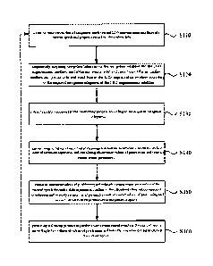
and thereby improve the accuracy of positioning solution. Fig. 1 shows a
22
2080832CN-CA
WSLEGAL\ 068076\ 00033 \29758467v1
Date Recue/Date Received 2023-03-15
flowchart of a positioning method according to an embodiment of the
present application. The method may be executed by a positioning system
which may be implemented in at least one of software and hardware.
Wherein the medium-, high-, low-orbit constellation multi-frequency
information sources include the multi-frequency information sources of at
least one of all existing satellite navigation systems and the LEO
augmentation satellite navigation system. As shown in Fig. 1, the
positioning method according to an embodiment of the present
application includes a step S110 to a step S160.
[0048] In the step S110, observation data of navigation satellites and
LEO augmentation satellites are acquired at a current epoch and
preprocessed. The process is as follows: acquiring multi-system
multi-band observation values and LEO augmentation satellite
observation values through receiver tracking and observations, and
preprocessing the data.
[0049] Wherein the navigation satellites include at least one of the US
GPS, China Beidou, EU Galileo, and Russian GLONASS satellite
navigation systems.
[0050] In the step S120, navigation telegrams of the navigation satellites
and the LEO augmentation satellites are acquired, and precise orbits and
clock biases of the navigation satellites and of the LEO augmentation
satellites are obtained at the same time according to the acquired
23
2080832CN-CA
WSLEGAL\ 068076 \ 00033 \29758467v1
Date Recue/Date Received 2023-03-15
navigation telegrams of the LEO augmentation satellites. The process is:
acquiring the navigation telegrams of the navigation satellites and the
LEO augmentation satellites, and using the number of orbits and the
clock bias coefficients provided by the navigation telegrams to interpolate
to obtain the satellite position and the satellite clock bias at the current
time point. Wherein because the LEO augmentation satellites have
different characteristics from the navigation satellites, the navigation
telegrams of the LEO augmentation satellites are different from the
navigation telegrams of the navigation satellites. For example, the
navigation telegrams of the LEO augmentation satellites have more types
of parameters. Therefore, the calculation of the orbits and clock biases of
the LEO augmentation satellites is also different from the calculation of
the orbits and clock biases of the navigation satellites. For example,
compared with the calculation of the orbits of the navigation satellites, in
the calculation of the orbits of the LEO augmentation satellites, more
perturbation factors need to be considered. Because the accuracy of the
orbits and satellite clock biases of the LEO augmentation satellites and
the navigation satellites given by the broadcast ephemeris generally
cannot meet the high-precision positioning requirements. In an
embodiment, in order to obtain real-time orbits and real-time clock biases
with high precision, State Space Representation (SSR) correction
information can be received in real time through the network.
24
2080832CN-CA
WSLEGAL\ 068076 \ 00033 \29758467v1
Date Recue/Date Received 2023-03-15
[0051] In the step S130, errors received in the positioning process are
corrected according to the acquired navigation telegrams.
[0052] Errors that can be corrected by the error model are corrected in the
step 130, and then errors that cannot be corrected by the error model are
corrected through the calculation of the positioning and velocity
measurement parameter observation values in the step S140 and the
estimation of the positioning and velocity measurement parameters in the
step S150. For the LEO augmentation satellites and the navigation
satellites, some errors are different, and the errors need to be corrected
correspondingly according to different satellite navigation systems.
[0053] In the positioning process, the positioning result is often affected
by multiple terms of errors, and weakening each error is the basis for
obtaining high-precision positioning results. According to the correlation,
these errors can be divided into errors related to the monitoring stations,
errors related to the satellites, and errors related to satellite signal
propagation. The commonly used methods to weaken the positioning
errors include model correction and parameter estimation. For some error
the physical characteristics of which has been understood, their
effects can be accurately eliminated by using correction formulas, such as
relativistic effects, earth rotation effects, etc.; for some error ten __ us
that
can be fitted with a model, their effects can be eliminated by using model
values obtained by the fitting model, such as solid earth tide correction,
2080832CN-CA
WSLEGAL\ 068076 \ 00033 \29758467v1
Date Recue/Date Received 2023-03-15
tropospheric correction, etc.; and for some other error terms with
unknown physical characteristics and poor model fitting, parameter
estimation methods can be used to eliminate their impact on positioning,
such as receiver clock biases, etc..
[0054] In the step S140, observation values of positioning and velocity
measurement parameters are calculated according to unified linear
observation equations obtained by normalizing by taking a type of
satellite navigation system as reference. The process is as follows:
according to the obtained observation data and navigation telegrams, the
position of the receiver through the above formula (9) is calculated, and
the clock bias of the receiver can also be calculated at the same time; the
velocity of the receiver can also be calculated through the above formula
(10).
[0055] In the step S150, according to the calculated observation values of
positioning and velocity measurement parameters and estimated values of
positioning and velocity measurement parameters at the previous epoch,
estimating positioning and velocity measurement parameters at the
present epoch through a state equation, to obtain estimated values of
positioning and velocity measurement parameters at the current epoch.
The process is as follows: according to the calculated observation values
of positioning and velocity measurement parameters and estimated values
of positioning and velocity measurement parameters at the previous
26
2080832CN-CA
WSLEGAL\ 068076 \ 00033 \29758467v1
Date Recue/Date Received 2023-03-15
epoch, calculating estimated values of positioning and velocity
measurement parameters at the present epoch through the above formula
(11), and saving the calculated estimated values of positioning and
velocity measurement parameters.
In the step S160, according to the estimated values of positioning and
velocity measurement parameters at the current epoch, positioning and
velocity measurement results at the current epoch are generated and saved,
and the processing returns to the step S110.
[0056] Fig. 2 shows a positioning system according to an embodiment of
the present application. Wherein the medium-, high-, low-orbit
constellation multi-frequency information sources include the
multi-frequency information sources of at least one of all existing satellite
navigation systems and the LEO augmentation satellite navigation
system.
[0057] As shown in Fig. 2, the positioning system according to an
embodiment of the present application includes: a satellite observation
data receiving and processing apparatus 11, a satellite navigation
telegram receiving and processing apparatus 12, a positioning error
correcting apparatus 13, a positioning and velocity measurement
parameter observation value calculating apparatus 14, a positioning and
velocity measurement parameter estimated value calculating apparatus 15
and a positioning and velocity measurement result saving apparatus 16.
27
2080832CN-CA
WSLEGAL\ 068076 \ 00033 \29758467v1
Date Recue/Date Received 2023-03-15
[0058] Wherein the satellite observation data receiving and processing
apparatus 11 is configured for acquiring observation data of navigation
satellites and LEO augmentation satellites at each epoch and
preprocessing the data.
[0059] The satellite navigation telegram receiving and processing
apparatus 12 is configured for acquiring navigation telegrams of the
navigation satellites and the LEO augmentation satellites at each epoch,
and at the same time obtaining precise orbit and clock bias of the
navigation satellites and of the LEO augmentation satellites according to
the acquired navigation telegrams of the LEO augmentation satellites. In
an embodiment, the satellite navigation telegram receiving and
processing apparatus 12 includes a navigation satellite navigation
telegram receiving and processing unit and a LEO augmentation satellite
navigation telegram receiving and processing unit.
[0060] The positioning error correcting apparatus 13 is configured for
correcting errors received in the positioning process according to the
acquired navigation telegrams. In an embodiment, the positioning error
correcting apparatus 13 includes a navigation satellite error correcting
unit and a LEO augmentation satellite error correcting unit.
[0061] The positioning and velocity measurement parameter observation
value calculating apparatus 14 is configured for normalizing by taking a
type of satellite navigation system as reference to obtain unified linear
28
2080832CN-CA
WSLEGAL\ 068076 \ 00033 \29758467v1
Date Recue/Date Received 2023-03-15
observation equations, and calculating observation values of positioning
and velocity measurement parameters according the unified linear
observation equations.
[0062] The positioning and velocity measurement parameter estimated
value calculating apparatus 15 is configured for estimating positioning
and velocity measurement parameters at the present epoch according to
the calculated observation values of positioning and velocity
measurement parameters and the saved estimated values of positioning
and velocity measurement parameters at the previous epoch, to obtain
estimated values of positioning and velocity measurement parameters at
the current epoch through a state equation.
[0063] The positioning and velocity measurement result saving apparatus
16 configured for generating and saving positioning and velocity
measurement results at the current epoch according to the estimated
values of positioning and velocity measurement parameters at the current
epoch.
[0064] Fig. 3 is a schematic diagram of the working principle of a fast
and precise positioning method provided by an embodiment of the
present application. Wherein the implementation of the positioning
method may include a navigation satellite constellation, a LEO
constellations, a ground operation and control system, and a user receiver.
Wherein: the navigation satellite constellation includes at least one of the
29
2080832CN-CA
WSLEGAL\ 068076 \ 00033 \29758467v1
Date Recue/Date Received 2023-03-15
US GPS, China Beidou, EU Galileo and Russian GLONASS satellite
navigation systems, and is configured for broadcasting navigation
satellite signals. The LEO constellation includes multiple LEO satellites
distributed on multiple orbital planes, and the multiple LEO satellites
broadcast navigation direct signals based on high-precision
time-frequency references through specific frequency bands to provide
stable coverage of the world or specific service areas, and is configured
for broadcasting navigation direct signals and navigation augmentation
information. The ground operation and control system perfoims business
calculation and processing, and controls and manages the satellites and
the constellations. The user receiver receives navigation direct signals
broadcasted by the navigation satellites and the LEO satellites, as well as
the navigation augmentation information broadcasted by the LEO
satellites, and performs precise positioning, velocity measurement and
timing based on the navigation direct signals from the navigation
satellites and the LEO satellites and the navigation augmentation
information.
2080832CN-CA
WSLEGAL\ 068076 \ 00033 \29758467v1
Date Recue/Date Received 2023-03-15