Note: Descriptions are shown in the official language in which they were submitted.
SPECIFICATION
TITLE: A PRACTICAL METHOD TO COLLECT AND MEASURE REAL-TIME TRAFFIC
DATA WITH HIGH ACCURACY THROUGH THE 5G NETWORK AND ACCESSING THESE
DATA BY CLOUD COMPUTING
TECHNICAL FIELD
The present invention belongs to the field of Transportation and Traffic
research
as well as the methodologies behind them.
EXISTING CURRENT SYSTEMS
To update traffic control systems and conduct traffic studies, it is essential
to
have reliable, accurate and up-to-date data on traffic flows. However, these
data
are generally unavailable, not recent enough, imprecise or difficult to
access.
In addition, there is no simple, efficient and economical method of collecting
traffic data and the most reliable is still the manual method. This method
involves
sending a technician to the field to manually count traffic flows in all
directions.
This is a process that spans several days and must be repeated regularly to
take
into account changes in traffic flows, new developments or improvements to the
road network. This is a tedious and expensive process that requires staff and
frequent trips on the road network.
Data can also be collected by origin-destination (0 / D) surveys, but this is
an
expensive and difficult method to optimize traffic light systems. Regarding
data
from mobile devices and GPS navigation systems, they are disseminated among
several providers and there are legal, security and privacy issues to
consider. In
addition, it is necessary to take into account the latency problem which
causes
delays in satellite transmission. This problem can interfere with real-time
interventions for traffic control.
1
Date Regue/Date Received 2022-08-01
There are also methods of collecting traffic data such as installing devices
permanently along the roads. These are detectors or sensors generally
connected to an on-site computer or to a laptop. The disadvantages of this
method relate to the wide variety of equipment on the market, their
installatiOn, the difficulty of making them work correctly and the complexity
of the data processing.
Our method is new and different from existing methods. This is a
=
photogrammetric, triangulation and picture recognition approach. It provides
for the installation of a series of georeferenced and synchronized cameras
which will be able to measure traffic flows simultaneously on several
.5 intersections or sections of the roads. In addition to traffic flows, it
makes it =
possible to measure the position, speed, acceleration and traffic density of
vehicles, pedestrians, cyclists and any object that moves in the area under
study and to process these data in a microscopic simulator or any kind of
simulator. The data will also be accessible by secure means and by cloud
computing.
Furthermore, some inventions have caught our attention, WO 2004/021303
"Method and device for determining traffic condition quantities" filed
on 21/08/2003 shows a method and arrangement for determining traffic
condition variables. A video camera records video pictures of a lane with
vehicles. This method determines traffic state variables, such as traffic flow
= speed and traffic density, from gray scale values of the video picture.
This is a
rough estimate of the traffic condition and it does not determine the exact
position of vehicles, pedestrians, cyclists or any object moving on a road as
we propose in our invention.
2
Date Recue/Date Received 2021-08-20
WO 95/25321 "Method of detecting traffic and traffic situations on roads,
preferably motorway? filed 01/03/1995. The method arranges measuring
points for vehicle detection using traffic sensors and a traffic data
processing
arrangement for traffic control are used to determine at regular intervals
traffic data, such as vehicle speed, traffic intensity and traffic density.
And
specific traffic parameters determined therefrom are formed in a traffic data
processing system. This method calculates the average speed of traffic at
regular intervals with sensors placed in sections across a road section and
does not determine the exact position of vehicles, pedestrians, cyclists or
any
object. which ,moves on a road as we propose in our invention.
OBJECTIVES AND ADVANTAGES
The main objective is to propose a practical method to count the flow of
vehicles, pedestrians, cyclists or any object moving on a section of road and
to measure the traffic density in order to be able to intervene in real time
and at the right time to better control the traffic systems.
Another principal objective is to offer an automatic real-time solution of
measuring the traffic flow on a road section or an intersection, the position
at any moment of vehicles, pedestrians, cyclists and any moving object and to
- measure the density of traffic precisely in each section of road in real
time.
Another objective is to make these data readily and easily available to
optimize the static traffic light systems of cities and agencies, to
dynamically
modify traffic light systems in real time, to dynamically modify traffic
control
systems (changing average vehicle speed, informing drivers for improving
traffic flow, etc.), to carry out various traffic studies or for other uses
related
to transport and mobility.
The counting of vehicles could be done more frequently, it is less costly in
the
long run and it is more practical and simpler than the existing methods.
3
Date Recue/Date Received 2021-08-20
The. present method offers a real-time solution of precise vehicle counting by
the mean of high speed cameras shooting a very large number of pictu res at
road intersections or road sections. The pictures are taken every fraction of
a
second for example to identify and measure precisely the flow of vehicles, of
pedestrians, cyclists, animals or of any other object moving on a section of
the road or through an intersection. These pictures are transferred to a
server by the 5G or any other fast and secure technology for processing. They
can also be processed on site with the "edge computing" approach. Pictures
processing is carried out by photogrammetric, triangulation and picture
recognition approaches in order to extract the position of each vehicle,
.pedestrian, cyclist or any object and identify its x, y, z coordinates in a
local
or global referencing system. This method makes it possible to deduce the
traffic flows in a faster and more practical way than the methods in force. It
can also extract other useful information such as position, average speed or
traffic density, which the manual counting method and other methods do not.
These pictures and data will be immediately transferred through a fast and
secure means for real-time use or stored on a server for processing and
future use. The access to the data reported by the pictures are available in
the cloud computing and could be used by cities, agencies, and other =
specialists in urban planning, transport or mobility.
My invention offers the present advantages:
A real-time collected data easily accessible by cloud computing,
5G or any other fast, secure and similar technology,
A better quality of the traffic data is collected,
An easily utilization of the data by cities, agencies, public bodies
or other person interested in improving mobility or studying traffic
phenomena,
.
4
Date Recue/Date Received 2021-08-20
The formatting and presentation of the data can be automated in
the same format as currently used by cities and agencies to optimize
current Traffic Lights Systems.
The formatting and presentation of the data can be automated in
the same format as currently used by cities and agencies for the use of
simulation and optimization software.
This method will make it possible to simulate reality with more
precision than current simulators; current simulators represent an
imprecise glimpse of reality which use statistical rules to generate the
arrival of vehicles and vehicle journeys from statistical rules such as
Poisson's Law, and which generates journeys from mathematical models
such as the "car-following-model".
This method makes it possible to reproduce the real movements
of vehicles, pedestrians, cyclists or other objects which move at every
split second, processes this data in the right format and transfer it into
a simulator and in real-time if necessary.
The data collected with this method combined with the use of a
micro-simulator or any type of simulator opens up unsuspected
prospects for improving the performance of traffic systems and for the
study of traffic phenomena such as the fundamental diagram and driver
behaviours in different contexts.
Note: A microscopic simulator or micro-simulator reproduces the
individual movements of vehicles, pedestrians or cyclists on a computer
screen. The simulation makes it possible to test the efficiency of traffic
control systems in force and to study traffic phenomena.
- - This method make it possible to evaluate the efficiency of a
network by reproducing the movements in a micro-simulator and by
5
Date Recue/Date Received 2021-08-20
measuring for example the cumulative waiting times on a part of the
network as happens in reality. This measure is currently impossible to
assess and cities and agencies rely on the decrease in the number of
complaints to judge whether a system is effective or better than
before.
This method allows to process the data in the right format and
transfer it into a micro-simulator and in real-time if necessary.
The average speed, acceleration or any other information can be
evaluated, and used to promote fluid circulation and mobility, reduce
congestion waves, waiting times, energy waste and pollution.
This method makes it possible to know the traffic density at any
time on a section of road and to remotely modify automatically or
manually the cycles and phases of a Traffic Lights System from a Traffic
Management Center.
Note: A Traffic Management Center (TMC) aims to monitor traffic
signals, intersections, and roads and proactively deploys traffic
management strategies to reduce congestion and improve mobility and
security. For the purposes of this invention, the Traffic Management
Center shown in Fig. 1 the number 34 includes related activities to
traffic managements and planning. These activities are generally
carried out by engineers, technicians and traffic experts from cities,
agencies, public bodies or others, for example, analysis and
management of traffic systems, urban studies, transport planning,
optimization of static traffic light systems, etc.
This method makes it possible to use these data and carry out
traffic studies or for any other purpose.
6
Date Recue/Date Received 2021-08-20
- This method gives a good accuracy of vehicle positions near
intersections in real time.
This method allows cities and agencies to update traffic light
systems at the frequency recommended by industry standards and the
Federal Highway Administration (FHWA), or even beyond those
standards.
These general disadvantages are avoided:
manual counting of vehicles,
a high number of workers to collect and treat data,
a high cost of data collection and updating of systems.
The present invention will be further understood from the following
description with reference to the drawings wherein like numbers refer to like
parts for easy identification.
BRIEF DESCRIPTION OF DRAWINGS FIGURES
FIG.1 is a complete view showing all the elements of the method.
FIG2 is a perspective view of high speed cameras at a road intersection.
FIG.3 is a perspective view of high speed cameras at a road section.
DETAILED DESCRIPTION OF THE PREFERRED EMBODIMENT
In the following description and in the accompanying drawings, the numeral
=
numbers refer to identical parts in the various Figures.
FIG.1 shows all the elements of the method 20, these elements comprise:
two high speed georeferenced and synchronised cameras 36,36'
placed at roads intersection 46 and taking picture; the camera 36' is
taking a picture 40 of the car 38 and a picture 41 of the car 38', the
camera 36 is taking a picture 42 of the car 38' and a picture 43 of the
car 38. These picture are taken from different angles of vehicles 38,38'
at a high speed (several pictures per second).
7
Date Recue/Date Received 2021-08-20
A 5G network 26 connected respectively 60',60 through two small
antennas or transmission accessories 24,22 to the high speed cameras
36,36'.
= A Center of Analysis and Treatment 30 receives 32 the pictures
from the 5G and processes them to obtain the real-time traffic data,
the data are sent 50 to the cloud 28 where they are easily accessible.
This is an automated way to get real-time traffic data and store them in
the cloud for use by a city, agency, public bodies or others.
A Traffic Management Center 34 represented by a road viewing
station, using screens and computers 35, where several decisions are
made to manage traffic in real-time.
The Center of Analysis and Treatment 30 can transmit directly data 51 to the
Traffic Management Center 34 by a fast and secure communication mean to
permit to intervene dynamically and remotely to improve circulation and
mobility, for example 58 to modify the sequences, cycles or phases of Traffic
Lights System 48 in real time.
The links 58 between the Traffic Management Center 34 and the Traffic Lights
System 48 is a secure mean of transmission like a dedicated internet link, a
fiber optic network or any secure and fast Communication mean.
The pictures can be also transmit 44 directly to the cloud 28 where they are
accessible to city, agencies, public bodies, or others 34 for some studies for
example.
The city, agencies, public bodies, or others 34 now can access 52 the real-
time traffic data from the cloud at any time and according to their needs.
The cities, agencies and public bodies can operate and optimize more
frequently Traffic Lights Systems 48 with the data obtained 52 and previously
processed by the Center of Analysis and Treatment 30.
8
Date Recue/Date Received 2021-08-20
The city, agencies, public bodies or others receive also 51 some interventions
or suggestions in real-time from the Center of Analysis and Treatment 30, for
example, they may receive real-time traffic data just collected directly from
the center 30 to avoid latency's loss. The links 51 can be for example a
secure
mean of transmission like a dedicated internet link, a direct communication
network, a fiber optic network or any secure and fast communication mean.
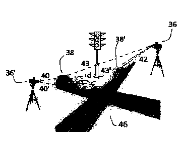
FIG.2 shows the road intersection 46 where the high speed cameras 36',36
take pictures 40,40',42,43,43 of vehicles 38',38 from different angles.
An example of consecutive photography is this, the photo 40' following the
photo 40 is taken after the car 38 has driven a distance d by the camera 36',
and the other camera 36 takes a photo 43' following the photo 43 of the.
same car 38 having driven a distance d. Photos 40 and 43 are taken
simultaneously, by cameras 36, 36' as are photos 40' and 43' in a similar
fashion.
FIG.3 shows a road section 56 where are high speed cameras 54,54' shooting
pictures at every fraction of a vehicle 38m in order to determine its position
(x, y, z) by triangulation at every moment.
SUMMARY OF THE INVENTION
The present invention is a method 20 of measuring real-time traffic data,
accessing and processing that data by cloud computing.
The method utilizes high-speed cameras 36,36',54,54' connected to the 5G
directly or via small antennas or transmission accessories 22,24. The SG can
be replace by any other fast and secure technology.
The high-speed cameras are installed in a suitable place or on the roadside
ready to take pictures of a road section or an intersection of the road where
are moving vehicles, pedestrians, cyclists, animals, or any other object.
9
Date Recue/Oate Received 2021-08-20
The pictures are taken simultaneously like every fraction of a second to be
able to identify vehicles, pedestrians, cyclists, animals or any other object
moving on a section of the road or through an intersection and to be a ble to
measure their position at every moment.
These cameras are georeferenced and synchronised to know the exact
position (x, y, z) of vehicles, people, cyclists or other objects that are
moving
at any time.
Several cameras will be able to operate in a synchronized manner to compare
the position of vehicles, people or other moving objects and thus increase
the accuracy of the data.
The pictures will be sent to a Center of Analysis and Treatment 30 to be
processed, these pictures will allow, after automated processing by artificial
vision algorithm and triangulation or others approaches to recognize the
exact position every split second of vehicles, pedestrians, cyclists or any
other object that moves on a section of road or through an intersection.
In order to identify vehicles, pedestrians, objects or other moving objects in
different lighting and visibility conditions, such as during the night and in
various climatic conditions, lidar sensors and infrared cameras can be use in
a
- similar fashion.
After processing the pictures, it will be possible to accurately measure
traffic
flows in all directions without installing expensive devices and without
connecting them to the infrastructure or IT systems of a city or an agency.
These data will be processable in the right format and accessible in the cloud
to reduce data collection costs, field trips to collect data, and for easily
and
more frequently updating Traffic Light Systems. It will also allow
transferring
the data collected into a micro-simulator or any kind of simulator in order to
better understand traffic phenomena, to develop more effective solutions
Date Recue/Date Received 2021-08-20
adapted to the context, driving habits and local culture, and to carry out
scientific research and new knowledge.
The data obtained after the treatment of the pictures are sent 50 in the cloud
28 and will be made available 52 to the Traffic Management Center 34 of
S
cities, agencies, public bodies or others for different purposes; for example
the management of traffic lights, the management of traffic control systems,
carrying out studies and analyzes related to transport and urban planning.
The city or agency can also update Traffic Lights Systems more frequently,
especially static systems that should be updated every three years, but the
majority of them are not updated frequently enough. The Traffic Management
Center of cities, agencies and public bodies can receive real-time
interventions or suggestions to improve traffic from the Center of Analysis
and Treatment 30, by a fast and secure communication mean 51 in order to
avoid latency's problems.
IN BRIEF
A method for collecting and measuring real-time traffic data and to make
them accessible through the cloud computing comprising the following steps:
a)
choose a series of high speed Internet Protocol (IP) geo-
referenced cameras,
b) install
at least two cameras at portions of the road, intersection
or road section, for shooting pictures at a high speed frequency of
vehicles, pedestrians, cyclists, animals, objects moving at said portion,
c)
synchronize these cameras so that they take series of pictures
every fraction of a second and from different points of view
simultaneously,
11
Date Recue/Date Received 2021-08-20
d) connect the cameras to the SG network to transfer the pictures
to a Center of Analysis and Treatment (30),
e) access and process the pictures in the Center of Analysis and
Treatment (30) in order to obtain accurate real-time traffic data,
f) process
the real-time traffic data by the said Center of Analysis
and Treatment (30) in order to propose intervention scenarios to a
Traffic Management Center (34) to enable it to intervene remotely,
dynamically and in real time on Traffic Lights System (48) in order to
improve traffic management and mobility,
g) send and
.store the data to the cloud and make it securely
accessible and in the appropriate format to be usable by cities,
agencies, public bodies and others.
These portions of the road are road sections or intersections.
The Center of Analysis and Treatment 30 processes the pictures by
determining the area, the average volume, the position occupied by each of
said vehicle, pedestrian, cyclist, animal or any moving object on said portion
of said road and calculates their position (x, y, z) according to a local or
global coordinate system to obtain said real-time traffic data.
The Center of Analysis and Treatment 30 can processes pictures with artificial
intelligence approaches to obtain the real-time traffic data.
The high speed georeferenced-cameras shoot pictures at a very high speed;
every fraction of a second.
The city, agency or public body is connected to the cloud for easy accessing
the real-time traffic data, and may receive directly real-time interventions
or
suggestions from the Center of Analysis and Treatment 30 by a fast and
12
Date Recue/Date Received 2021-08-20
=
secure communication mean 51, in order to avoid latency's problems. The
city, agency or public body can manage transport and urban planning by the
mean of these traffic data. An example of management is a city that remotely
controls a Traffic Lights System 48 from a Traffic Management Center 34 and
the Traffic Lights System 48 by a fast and secure mean of transmission like a
dedicated internet link, a fiber optic network or any secure and fast
communication mean.
The 5G can be modified, adapted, updated, renamed, or replaced over time
by the responsible authorities or according to the rules of international
standardization. The 5G =can be replace by any other fast and secure
technology.
In different lighting and visibility conditions on the roadside infrared
cameras
and lidar sensors can be used.
The real-time traffic data can be anonymized to respect privacy issues.
It is to be clearly understood that the instant description with reference to
the annexed drawing is made in an indicative manner and that the preferred
embodiments described herein are meant in no way to limit further
embodiments realizable within the scope of the invention. The matter which
is claimed as being inventive and new is limited only by the following claims.
25
13
Date Recue/Date Received 2021-08-20
PARTS
20 Method to collect and measure real-time traffic data with
high
accuracy through the 5G network and accessing these data by
cloud computing
22,24 Small antennas or transmission accessories
26 5G 28 The cloud
30 Center of Analysis and Treatment of the pictures and data
32 Signal between the 5G and the Center of Analysis and
Treatment
34 Traffic Management Center of cities, agencies or public
bodies
35 Screens, computers, software, equipment to monitor and manage
traffic systems
36,36' High speed cameras at the road intersection
38,38%38' Vehicles
40,40%41 Flashs of the camera 36'
42,43,43' Flash of the camera 36
44 Signal between the cloud and the 5G
46 A road intersection 48 Traffic Lights
System
50 Signal between the Center of Analysis and Treatment and the
cloud =
51 Real-time interventions transmission
52 Signal between the cloud and the city, agencies, public
bodies 34
54 A high speed camera in the road section 56
56 A road section
58 Signal between the Traffic Management Center 34 and the
Traffic
Lights System 48
60,60' Signals between respectively small antennas or transmission
accessories 22,24 and the 5G 26
14
Date Recue/Date Received 2021-08-20