Note: Descriptions are shown in the official language in which they were submitted.
4D TIME SHIFT AND AMPLITUDE JOINT
INVERSION FOR VELOCITY PERTURBATION
.. [0001]
[0002] The present disclosure relates generally to identifying changes within
a subsurface
region of the Earth over a period of time using seismic survey results. The
present disclosure
also relates generally to aligning seismic images that represent the same area
of subsurface
during a seismic survey.
[0003] This section is intended to introduce the reader to various aspects of
art that may be
related to various aspects of the present disclosure, which are described
and/or claimed
below. This discussion is believed to be helpful in providing the reader with
background
information to facilitate a better understanding of the various aspects of the
present
disclosure. Accordingly, it should be understood that these statements are to
be read in this
light, and not as admissions of prior art.
[0004] A seismic survey includes generating an image or map of a subsurface
region of the
Earth by sending sound energy down into the ground and recording the reflected
sound
energy that returns from the geological layers within the subsurface region.
During a seismic
survey, an energy source is placed at various locations on or above the
surface region of the
Earth, which may include hydrocarbon deposits. Each time the source is
activated, the source
generates a seismic (e.g., sound wave) signal that travels downward through
the Earth, is
reflected, and, upon its return, is recorded using one or more receivers
disposed on or above
Date recue/Date received 2023-04-21
CA 03137943 2021-10-25
WO 2020/222975
PCT/US2020/026853
the subsurface region of the Earth. The seismic data recorded by the receivers
may then be
used to create an image or profile of the corresponding subsurface region.
[0005] Over time, as hydrocarbons are being extracted from the subsurface
region of the
Earth, the location, saturation, and other characteristics of the hydrocarbon
reservoir (e.g.,
.. overburden, interval) within the subsurface region may change. As such, it
may be useful to
determine how the image or map of the subsurface region changes over time,
such that the
operations related to extracting the hydrocarbons may be modified to more
efficiently extract
the hydrocarbons from the subsurface region of the Earth.
SUMMARY
[0006] A summary of certain embodiments disclosed herein is set forth below.
It should be
understood that these aspects are presented merely to provide the reader with
a brief summary
of these certain embodiments and that these aspects are not intended to limit
the scope of this
disclosure. Indeed, this disclosure may encompass a variety of aspects that
may not be set
forth below.
[0007] A method of single trace inversion for estimating the velocity
perturbation from a 4D
seismic dataset of a subsurface region is provided. The 4D seismic dataset
includes two 3D
surveys from two points in time of the same area ¨ a base or baseline survey
and a monitor
survey. The base survey and monitor survey each have seismic traces
representative of the
.. manner in which seismic waves are reflected within the subsurface region.
Velocity changes
of the seismic waves used for the 3D surveys lead to time shift in the traces.
Amplitude
changes between the base traces and monitor traces can result from either
velocity
perturbation and/or density perturbation. For some cases, if density
perturbation is
2
CA 03137943 2021-10-25
WO 2020/222975
PCT/US2020/026853
negligible, the velocity perturbation will be the reason for both time shift
and amplitude
change.
[0008] The single trace inversion process of one or more embodiments uses the
two 3D
seismic datasets (including a base seismic trace and a monitor seismic trace),
and an
estimated wavelet for the reservoir of the subsurface region. An objective
function used for
the inversion process is defined with least-square minimization. Specifically,
one or more
embodiments minimizes a least squares difference between a predicted monitor
seismic trace
and an observed monitor seismic trace (where the difference is expressed by
the objective
function). Velocity perturbation, which is represented in the objective
function, is iteratively
estimated to minimize the least squares difference between the predicted
monitor seismic
trace (generated based upon the base seismic trace) and the observed monitor
seismic trace.
The generated predicted monitor seismic trace generally has two parts. One
part applies the
time shift (which results from estimated velocity perturbation) to the base
seismic trace, and
another part compensates the amplitude change from the baseline seismic trace
to the monitor
seismic trace with estimated velocity perturbation. A time shift correction is
also applied to
the amplitude change.
[0009] Once the velocity perturbation is estimated to the point where the
difference between
the predicted monitor trace and the observed monitor trace is at or below a
threshold, the
estimated velocity perturbation may be used to characterize changes in the
subsurface region
under study. As an example, a map of velocity perturbation of the subsurface
region may be
generated to characterize changes in the region between the time when the base
survey is
taken and the time when the monitor survey is taken.
3
CA 03137943 2021-10-25
WO 2020/222975
PCT/US2020/026853
BRIEF DESCRIPTION OF THE DRAWINGS
[0010] Various aspects of this disclosure may be better understood upon
reading the
following detailed description and upon reference to the drawings in which:
[0011] FIG. 1 is a flow chart of various processes that may be performed based
on analysis of
seismic data acquired via a seismic survey system, in accordance with
embodiments
presented herein;
[0012] FIG. 2 is a schematic side view of an example marine survey system in a
marine
environment, in accordance with embodiments presented herein;
[0013] FIG. 3 is a schematic side view of an example land survey system in a
non-marine
.. environment, in accordance with embodiments presented herein;
[0014] FIG. 4 is a diagrammatical representation of an example computing
system that
performs operations described herein based on data acquired via the marine
survey system of
FIG. 2 or the land survey system of FIG. 3, in accordance with embodiments
presented
herein;
[0015] FIG. 5 is a process flow diagram of an embodiment of a method of
characterizing
evolution in a subsurface region by way of single trace inversion performed on
a 4D seismic
data set, in accordance with embodiments presented herein;
[0016] FIG. 6 is a schematic overview of an example of the manner in which an
objective
function of the present disclosure operates to produce a predicted monitor
trace from a base
seismic trace using estimated velocity perturbation, in accordance with
embodiments
presented herein;
[0017] FIGS. 7A-7C illustrate a comparison between a true velocity model and
velocity
models produced according to the single trace inversion techniques of the
present disclosure,
in accordance with embodiments presented herein;
4
CA 03137943 2021-10-25
WO 2020/222975
PCT/US2020/026853
[0018] FIGS. 8A and 8B illustrate a comparison between velocity models where
amplitude
change is not time shifted and where amplitude change is time shifted, in
accordance with
embodiments presented herein;
[0019] FIG. 9 is a plot of density perturbation and velocity perturbation as a
function of
reservoir materials, in accordance with embodiments presented herein; and
[0020] FIG. 10 is a comparison between example inversion results, the results
being
produced by an objective function where a scalar is not used to account for
density
perturbation, and by an objective function where a scalar is used to account
for density
perturbation, in accordance with embodiments presented herein.
DETAILED DESCRIPTION OF SPECIFIC EMBODIMENTS
[0021] One or more specific embodiments will be described below. In an effort
to provide a
concise description of these embodiments, not all features of an actual
implementation are
described in the specification. It should be appreciated that in the
development of any such
actual implementation, as in any engineering or design project, numerous
implementation-
specific decisions must be made to achieve the developers' specific goals,
such as compliance
with system-related and business-related constraints, which may vary from one
implementation to another. Moreover, it should be appreciated that such a
development
effort might be complex and time consuming, but would nevertheless be a
routine
undertaking of design, fabrication, and manufacture for those of ordinary
skill having the
benefit of this disclosure.
[0022] As discussed above, seismic data processing may provide valuable
information with
regard to subsurface regions of the Earth, such as the location and
characteristics of
hydrocarbon deposits. Seismic data taken over time may also be processed to
assess how
5
CA 03137943 2021-10-25
WO 2020/222975
PCT/US2020/026853
those regions may change over time (evolve), for example due to hydrocarbon
production.
Based on how the geological formation of the Earth and the location and
characteristics of the
hydrocarbon deposits change over time, hydrocarbon production operations may
be modified
to extract hydrocarbon deposits more efficiently.
[0023] One manner of obtaining more accurate data representing geological
formations
includes performing, in accordance with the present disclosure, a method of
single trace
inversion for estimating the velocity perturbation from a 4D seismic dataset.
Generally, a 4D
seismic dataset of the present disclosure includes at least two 3D surveys
from two or more
time points of the same area/field. For simplicity, two 3D surveys taken at
different points in
time are discussed. As described herein, "inversion" is intended to denote a
process where a
model of a subsurface region is estimated based on acquired seismic data
(e.g., seismic
surveys).
[0024] One of the 3D surveys (e.g., a first survey) may be considered a base
seismic survey
or a "base survey," and another of the 3D surveys (e.g., a second survey) may
be considered a
monitor seismic survey or a "monitor survey." The base survey and the monitor
survey both
include a corresponding set of seismic traces, and the seismic traces of each
of the surveys is
representative of the subsurface region being analyzed at a respective point
in time (or time
period). In accordance with present embodiments, the base survey is performed
before the
monitor survey. Thus, differences between the surveys may be indicative of
changes in the
subsurface region of interest, and the monitor survey may be taken to evaluate
changes in the
subsurface region some period of time after the base survey, for example to
evaluate how
hydrocarbon production has affected the subsurface region.
[0025] More specifically, changes in the subsurface region between the time at
which the
base survey is taken and the time at which the monitor survey is taken will
result in changes
in the propagation of seismic waves through the region. For example, changes
in the
6
CA 03137943 2021-10-25
WO 2020/222975
PCT/US2020/026853
subsurface region may include a change in the materials in the region, which
can affect the
speed at which seismic waves propagate through the region and the nature of
the reflections
of seismic waves. Accordingly, seismic traces of the base survey and the
monitor survey
may differ in terms of the amplitude of various peaks of the seismic waves,
and the seismic
traces may differ in terms of the time at which these peaks are received at
the receivers which
generate each individual seismic trace. Each seismic trace may include a
series of points, and
each of these points may have an associated velocity at that point for the
seismic wave. A
difference in velocity at a given point between a base survey trace and a
monitor survey trace
can be evaluated to determine, for example, changes in the subsurface region
at a location
corresponding to the point.
[0026] In accordance with the present embodiments, shifting the base survey
traces to match
the monitor survey traces may be performed to estimate localized velocity
perturbations. As
described herein, a velocity perturbation is considered to represent, at a
given point on a
seismic trace, a perturbation in the velocity of a seismic wave between the
base seismic
survey and the monitor seismic survey at that point. The velocity perturbation
at a point on a
seismic trace may be expressed mathematically as the difference in the
velocity between the
base survey and the monitor survey at the point, divided by the velocity of
the base survey at
that point.
[0027] The localized velocity perturbations may be used collectively to
evaluate changes in
the subsurface region. As an example, a local velocity perturbation may
generally be
considered to result from a change in the seismic reflector at that location.
Thus, a map of
velocity perturbation of the subsurface region may be generated to show how
the materials in
that region have changed over time. This, in turn, may allow production
processes to be
adjusted to enhance efficiency of subsurface operations, such as hydrocarbon
extraction.
7
CA 03137943 2021-10-25
WO 2020/222975
PCT/US2020/026853
[0028] The shifting of the base seismic trace to match the monitor seismic
trace may be
performed by a process in which the velocity perturbation between individual
data points of
the base and monitor traces is iteratively estimated. The iterations are
performed until a
difference between the base and monitor traces is minimized to a predetermined
threshold.
Once the difference is minimized in this fashion, the velocity perturbations
may be used to
construct the velocity map noted above.
[0029] One or more embodiments can perform minimization of the difference (as
expressed
via an objective function), where the minimization is performed by
implementing a least
squares optimization algorithm. The optimization algorithm may account for
changes
between the base survey and the monitor survey that arise from time shifts and
that arise from
amplitude changes.
[0030] As one example, a computing system may use the velocity perturbation
characteristics
to update various seismic velocity models, seismic images, reservoir
characteristic maps, and
the like to more accurately determine the locations and properties of various
geological
.. formations within the subsurface region of the Earth. As such, hydrocarbon
exploration
operations (e.g., drilling, selection of drilling locations, production) may
be improved by
modifying the operations according to the updated locations and properties of
the
hydrocarbon deposits within the subsurface region according to the updated
velocity models
or updated seismic images.
.. [0031] By way of introduction, seismic data may be acquired using a variety
of seismic
survey systems and techniques, two of which are discussed with respect to FIG.
2 and FIG. 3.
Regardless of the seismic data gathering technique utilized, after the seismic
data is acquired,
a computing system may analyze the acquired seismic data and may use the
results of the
seismic data analysis (e.g., seismogram, map of geological formations) to
perform various
operations within the hydrocarbon exploration and production industries. For
instance, FIG.
8
CA 03137943 2021-10-25
WO 2020/222975
PCT/US2020/026853
1 illustrates a flow chart of a method 10 that details various processes that
may be undertaken
based on the analysis of the acquired seismic data. Although the method 10 is
described in a
particular order, it is noted that the method 10 may be performed in any
suitable order.
[0032] Referring now to FIG. 1, at block 12, locations and properties of
hydrocarbon deposits
within a subsurface region of the Earth associated with the respective seismic
survey may be
determined based on the analyzed seismic data. In one embodiment, the seismic
data
acquired via multiple sources and receivers or at different times may be
analyzed to generate
a map or profile that illustrates various geological formations within the
subsurface region.
[0033] Based on the identified locations and properties of the hydrocarbon
deposits, at block
14, certain positions or parts of the subsurface region may be explored. That
is, hydrocarbon
exploration organizations may use the locations of the hydrocarbon deposits to
determine
locations at the surface of the subsurface region to drill into the Earth. As
such, the
hydrocarbon exploration organizations may use the locations and properties of
the
hydrocarbon deposits and the associated overburdens to determine a path along
which to drill
into the Earth, how to drill into the Earth, and the like.
[0034] After exploration equipment has been placed within the subsurface
region, at block
16, the hydrocarbons that are stored in the hydrocarbon deposits may be
produced via natural
flowing wells, artificial lift wells, and the like. At block 18, the produced
hydrocarbons may
be transported to refineries and the like via transport vehicles, pipelines,
and so forth. At
block 20, the produced hydrocarbons may be processed according to various
refining
procedures to develop different products using the hydrocarbons.
[0035] It should be noted that the processes discussed with regard to the
method 10 may
include other suitable processes that may be based on the locations and
properties of
hydrocarbon deposits as indicated in the seismic data acquired via one or more
seismic
9
CA 03137943 2021-10-25
WO 2020/222975
PCT/US2020/026853
survey. As such, it should be understood that the processes described above
are not intended
to depict an exhaustive list of processes that may be performed after
determining the
locations and properties of hydrocarbon deposits within the subsurface region.
For instance,
the acts represented by block 12 may also include obtaining and analyzing
additional seismic
data, for example at a later point in time, to evaluate changes in a given sub-
surface reservoir
(e.g., based on velocity perturbation estimation) for more efficient recovery
of hydrocarbons.
[0036] With the forgoing in mind, FIG. 2 illustrates a marine survey system 22
(e.g., for use
in conjunction with block 12 of FIG. 1) that may be employed to acquire
seismic data
regarding a subsurface region of the Earth in a marine environment. Generally,
a marine
seismic survey using the marine survey system 22 may be conducted in an ocean
24 or other
body of water over a subsurface region 26 of the Earth that lies beneath a
seafloor 28.
[0037] The marine survey system 22 may include a vessel 30, a seismic source
32, a streamer
34, a receiver 36, and/or other equipment that may assist in acquiring seismic
images
representative of geological formations within the subsurface region 26 of the
Earth. The
vessel 30 may tow the seismic source 32 (e.g., airgun array) that may produce
energy, such as
sound waves (e.g., seismic waveforms), that is directed at a seafloor 28. The
vessel 30 may
also tow the streamer 34 having a receiver 36 (e.g., hydrophones) that may
acquire seismic
waveforms that represent the energy output by the seismic sources 32
subsequent to being
reflected off of various geological formations within the subsurface region
26. Although the
receiver 36 is described as being towed by the vessel 30, in some embodiments,
receiver 36
may also be deployed on the surface of the seafloor 28. Additionally, although
the
description of the marine survey system 22 is described with one seismic
source 32
(represented in FIG. 2 as an airgun array) and one receiver 36 (represented in
FIG. 2 as a
plurality of hydrophones), it should be noted that the marine survey system 22
may include
multiple seismic sources 32 and multiple seismic receivers 36. In the same
manner, although
CA 03137943 2021-10-25
WO 2020/222975
PCT/US2020/026853
the marine survey system 22 is described above with respect to one seismic
streamer 34, it
should be noted that the marine survey system 22 may include multiple seismic
streamers 34.
In addition, additional vessels 30 may include additional sources 32,
streamers 34, and the
like to perform the operations of the survey system.
[0038] FIG. 3 illustrates an embodiment of a land survey system 38 (e.g., for
use in
conjunction with block 12 of FIG. 1) that may be employed to obtain
information regarding
the subsurface region 26 of the Earth in a non-marine environment. The land
survey system
38 may include a land-based seismic source 40 positioned on a surface 42 of
the Earth, and
one or more land-based receivers 44 also positioned on the surface 42 (or
other appropriate
location). In some embodiments, the land survey system 38 may include more
than one
seismic source 40 and first and second receivers 44 and 46. Indeed, for
discussion purposes,
FIG. 3 includes one land-based seismic source 40 and two seismic receivers 44
and 46. The
land-based seismic source 40 may produce energy (e.g., sound waves, seismic
waveforms)
that is directed at the subsurface region 26 of the Earth. Upon reaching
various geological
formations (e.g., salt domes, faults, folds) within the subsurface region 26
the energy output
by the land-based seismic source 40 may be reflected off of the geological
formations (e.g.,
interfaces between different formation materials) and acquired or recorded by
one or more
land-based receivers (e.g., 44 and 46) as raw signals.
[0039] In some embodiments, the land-based receivers 44 and 46 may be
dispersed across the
surface 42 to form a grid-like pattern. As such, each land-based receiver 44
or 46 may
receive a signal corresponding to a reflected seismic waveform in response to
energy being
directed at the subsurface region 26 via the seismic source 40. In some cases,
one seismic
waveform produced by the seismic source 40 may be reflected off of different
geological
formations and received by different receivers. For example, as shown in FIG.
3, the seismic
source 40 may output energy that may be directed at the subsurface region 26
as a seismic
11
CA 03137943 2021-10-25
WO 2020/222975
PCT/US2020/026853
waveform 48. A first receiver 44 may receive the reflection of the seismic
waveform 48 off
of one geological formation and a second receiver 46 may receive the
reflection of the
seismic waveform 48 off of a different geological formation. As such, the
first receiver 44
may receive a first reflected seismic waveform 50 and the second receiver 46
may receive a
second reflected seismic waveform 52.
[0040] The received data for each of these channels (the first and second
receivers 44, 46)
may be processed to produce a collection of seismic traces. The collection of
seismic traces
over all the receivers used by the system 38 at a given time (e.g., a first
time period) may be
referred to as the set of traces corresponding to a given seismic survey.
Seismic surveys may
be conducted at different points in time to evaluate changes in the sub-
surface reservoir.
[0041] Regardless of how the seismic data is acquired, a computing system
(e.g., for use in
conjunction with block 12 of FIG. 1) may analyze the signals (seismic
waveforms) acquired
by the marine-based receivers 36 or the land-based receivers 44 and 46 to
determine
information regarding the geological structure, the location and property of
hydrocarbon
deposits, and the like within the subsurface region 26. FIG. 4 illustrates an
example of such a
computing system 60 that may perform various data analysis operations to
analyze the
seismic data acquired by the receivers 36, 44, or 46 to determine the
structure of and/or
evaluate changes in the geological formations within the subsurface region 26.
Indeed, as
discussed herein, the computing system 60 of the present disclosure is
programmed to
perform the seismic survey adjustments, seismic trace inversions, and analyses
described
herein.
[0042] Referring now to FIG. 4, the computing system 60 may include a
communication
component 62, a processor 64, a memory 66, a storage 68, input/output (I/O)
ports 70, a
display 72, and the like. The communication component 62 may be a wireless or
wired
communication component that may facilitate communication between the
receivers 36, 44,
12
CA 03137943 2021-10-25
WO 2020/222975
PCT/US2020/026853
46, one or more databases 74, other computing devices, and other communication
capable
devices. In one embodiment, the computing system 60 may receive receiver data
76 (e.g.,
signals, seismic data, seismograms, seismic traces) that may have been
previously acquired
by seismic receivers via a network component, the database 74, or the like.
The processor 64
of the computing system 60 may analyze or process the receiver data 76 to
ascertain various
features regarding geological formations within the subsurface region 26 of
the Earth.
[0043] The processor 64 may be any type of computer processor or
microprocessor capable
of executing computer-executable code. The processor 64 may also include
multiple
processors that may perform the operations described below. The memory 66 and
the storage
68 may be any suitable articles of manufacture that can serve as media to
store processor-
executable code, data, or the like. These articles of manufacture may
represent computer-
readable media (e.g., any suitable form of memory or storage) that may store
the processor-
executable code used by the processor 64 to perform the presently disclosed
techniques.
Generally, the processor 64 may execute software applications that include
programs that
process seismic data acquired via receivers of a seismic system according to
the embodiments
described herein.
[0044] The memory 66 and the storage 68 may also be used to store the data,
analysis of the
data, the software applications, and the like. The memory 66 and the storage
68 may
represent non-transitory computer-readable media (e.g., any suitable form of
memory or
storage) that may store the processor-executable code used by the processor 64
to perform
various techniques described herein. It should be noted that non-transitory
merely indicates
that the media is tangible and not a signal.
[0045] The I/O ports 70 may be interfaces that may couple to other peripheral
components
such as input devices (e.g., keyboard, mouse), sensors, input/output (I/O)
modules, and the
13
CA 03137943 2021-10-25
WO 2020/222975
PCT/US2020/026853
like. I/O ports 70 may allow the computing system 60 to communicate with the
other devices
in the marine survey system 22, the land survey system 38, or the like via the
I/O ports 70.
[0046] The display 72 may depict visualizations associated with software or
executable code
being processed by the processor 64. In one embodiment, the display 72 may be
a touch
display capable of receiving inputs from a user of the computing system 60.
The display 72
may also be used to view and analyze results of the analysis of the acquired
seismic data to
determine the geological formations within the subsurface region 26, the
location and
property of hydrocarbon deposits within the subsurface region 26, and the
like. The display
72 may be any suitable type of display, such as a liquid crystal display
(LCD), plasma
display, or an organic light emitting diode (OLED) display, for example. In
addition to
depicting the visualization described herein via the display 72, it should be
noted that the
computing system 60 may also depict the visualization via other tangible
elements, such as
paper (e.g., via printing) and the like.
[0047] With the foregoing in mind, the present techniques described herein may
also be
performed using a supercomputer that employs multiple computing systems 60, a
cloud-
computing system, or the like to distribute processes to be performed across
multiple
computing systems. In this case, each computing system 60 operating as part of
a super
computer may not include each component listed as part of the computing system
60. For
example, each computing system 60 may not include the display component 72
since
multiple display components 72 may not be useful to for a supercomputer
designed to
continuously process seismic data.
[0048] After performing various types of seismic data processing, the
computing system 60
may store the results of the analysis in one or more databases 74. The
databases 74 may be
communicatively coupled to a network that may transmit and receive data to and
from the
computing system 60 via the communication component 62. In addition, the
databases 74
14
CA 03137943 2021-10-25
WO 2020/222975
PCT/US2020/026853
may store information regarding the subsurface region 26, such as previous
seismograms,
geological sample data, seismic images, seismic traces, and the like generated
from surveying
the subsurface region 26.
[0049] Although the components described above have been discussed with regard
to the
computing system 60, it should be noted that similar components may make up
the
computing system 60. Moreover, the computing system 60 may also be part of the
marine
survey system 22 or the land survey system 38, and thus may monitor and
control certain
operations of the sources 32 or 40, the receivers 36, 44, 46, and the like.
Further, it should be
noted that the listed components are provided as example components and the
embodiments
described herein are not to be limited to the components described with
reference to FIG. 4.
[0050] In some embodiments, the computing system 60 may generate a two-
dimensional
representation or a three-dimensional representation of the subsurface region
26 based on the
seismic data received via the receivers mentioned above. Additionally, seismic
data
associated with multiple source/receiver combinations may be combined to
create a near
continuous profile of the subsurface region 26 that can extend for some
distance. In a two-
dimensional (2-D) seismic survey, the receiver locations may be placed along a
single line,
whereas in a three-dimensional (3-D) survey the receiver locations may be
distributed across
the surface in a grid pattern. As such, a 2-D seismic survey may provide a
cross sectional
picture (vertical slice) of the Earth layers as they exist directly beneath
the recording
locations. A 3-D seismic survey, on the other hand, may create a data "cube"
or volume that
may correspond to a 3-D picture of the subsurface region 26.
[0051] In addition, a 4-D (or time-lapse) seismic survey may include seismic
data acquired
during a 3-D survey at multiple times. Using the different seismic images
acquired at
different times, the computing system 60 may compare the two images to
identify changes in
.. the subsurface region 26.
CA 03137943 2021-10-25
WO 2020/222975
PCT/US2020/026853
[0052] In any case, a seismic survey may be composed of a very large number of
individual
seismic recordings or traces. As such, the computing system 60 may be employed
to analyze
the acquired seismic data to obtain an image representative of the subsurface
region 26 and to
determine locations and properties of hydrocarbon deposits, as well as changes
occurring
over time in the subsurface region 26 (e.g., due to hydrocarbon production). A
variety of
seismic data processing algorithms may be stored and executed by the computing
system 60
to, for instance, remove noise from the acquired seismic data, migrate the pre-
processed
seismic data, identify shifts between multiple seismic images, align multiple
seismic images,
and the like.
100531 After the computing system 60 analyzes the acquired seismic data, the
results of the
seismic data analysis (e.g., seismogram, seismic images, map of geological
formations, etc.)
may be used to perform various operations within the hydrocarbon exploration
and
production industries. For instance, as described above, the acquired seismic
data may be
used to perform the method 10 of FIG. 1 that details various processes that
may be
undertaken based on the analysis of the acquired seismic data.
[0054] Using any one or a combination of the systems described above with
respect to FIGS.
2-4, it is now recognized that it may be possible to perform methods of single
trace inversion
to estimate velocity perturbations for a 4D seismic data set. The 4D seismic
data set
generally includes at least two 3D seismic data sets from two time points of
the same field of
observation. FIG. 5 depicts an embodiment of a method 80 of performing single
trace
inversion to estimate velocity perturbation, and thereafter characterize a
subsurface region of
the Earth using the estimates. By way of example, the method 80 may be
performed in part
or in full by the computing system 60 of FIG. 4.
[0055] The method 80 generally includes obtaining a 4D seismic data set of a
subsurface
region ¨ specifically illustrated as obtaining (block 82) a base survey with
seismic data
16
CA 03137943 2021-10-25
WO 2020/222975
PCT/US2020/026853
obtained at a first time and obtaining (block 84) a monitor survey with
seismic data obtained
at a second time after the first time. As an example, the base survey may be
conducted before
hydrocarbon production from a subsurface region, and the monitor survey may be
conducted
after some amount of hydrocarbon production has been performed. However, the
present
disclosure is not limited to such situations, and the base and monitor surveys
may be
conducted at any of at least two different time points with respect to the
production of
hydrocarbons from the subsurface region.
[0056] As discussed herein, the seismic data obtained for the base and monitor
surveys
generally includes acquiring and/or processing the seismic data to produce a
series of seismic
traces. That is, the base seismic survey is associated with a set of base
seismic traces and the
monitor seismic survey is associated with a set of monitor seismic traces. It
should be noted
that obtaining such data in accordance with blocks 82 and 84 may involve
performing the
measurements themselves (e.g., transmitting waveforms into the subsurface
region and
collecting resulting waveforms), or, in some instances, may involve accessing
the data (e.g.,
using the computing system 60) from the database 74. Further still, in certain
embodiments,
the acts of blocks 82 and 84 may simply represent receiving acquired base and
monitor
seismic data. The base seismic traces and the monitor seismic traces are
generally
representative of geological characteristics of the subsurface region at the
time their
respective surveys are acquired. More specifically, the seismic traces
represent the manner in
which a seismic waveform is perturbed from its original state due to changes
in reflection
coefficient as the waveform travels along a subsurface path from source to
detector. The
changes in reflection coefficient generally relate to changes in the material
through which the
seismic waveform passes, or interfaces where the wavelet partially reflects or
refracts.
[0057] Thus, in accordance with present embodiments, the acts represented by
blocks 82 and
84 may produce base seismic traces and monitor seismic traces. As set forth
above, the
17
CA 03137943 2021-10-25
WO 2020/222975
PCT/US2020/026853
present disclosure includes a method of single trace inversion, where
individual base seismic
traces are modified to produce corresponding estimated monitor seismic traces.
The
difference between the corresponding estimated monitor seismic traces and the
monitor
seismic traces is then minimized, until a threshold is reached, to produce a
series of estimated
velocity perturbations for the subsurface region.
[0058] Referring again to the method 80, the acts represented by blocks 82 and
84 are thus
followed by a process in which the computing system 60 performs single trace
inversion
(block 86), which is described in further detail below. The output of the
computing system
60, upon performing the single trace inversion process, may include, by way of
non-limiting
example, a series of estimated velocity perturbations for each base seismic
trace and a
corresponding monitor seismic trace.
[0059] In this way, the base seismic survey includes a multitude of such base
seismic traces,
and the monitor seismic survey includes a multitude of such monitor seismic
traces. In
certain embodiments, the base seismic survey and the monitor seismic survey
are generally
performed in the same manner, such that the sources and detectors used for the
surveys are
generally positioned at the same location on the ground (e.g., with respect to
the subsurface
region of interest). If they are not positioned at generally the same
location, methods exist in
the art that may allow the computing system 60 to perform corrective alignment
techniques to
allow the base and monitor seismic surveys to be compared.
[0060] Regarding the single trace inversion process performed by the computing
system 60,
each base seismic trace may be represented by a series of amplitude values as
a function of
time, b (t), and the monitor seismic trace may have a similar corresponding
representation
m(t). The number of amplitude values for the base and monitor seismic traces
is variable
depending, specifically, on the sampling rate used to acquire the traces and
the overall
acquisition time. Thus, the base seismic trace b (t) may be considered to
include a number of
18
CA 03137943 2021-10-25
WO 2020/222975
PCT/US2020/026853
different amplitude values b(ti), where b(ti) is an amplitude value for the
base seismic trace
at a particular sampling time ti. The monitor seismic traces are similarly
represented (by
m(t3) and, thus, there are acquisition time-corresponding points ti for the
base seismic trace
and the monitor seismic trace.
[0061] Further, each base seismic trace will have a single corresponding
monitor seismic
trace. That is, for each base seismic trace b(t) there is a monitor seismic
trace m(t) that
corresponds in position to that base seismic trace. Differences between
corresponding base
and monitor traces that may be considered by the computing system 60 may
include, by way
of non-limiting example, waveforms that appear to have different peaks,
corresponding peaks
that have different amplitudes, and corresponding peaks that occur at
different time points
with respect to the acquisition time of the respective trace (e.g., one trace
appears to be time-
shifted with respect to the other). Such differences may be further
appreciated with respect to
the base seismic trace and monitor seismic trace shown as the outermost traces
described in
further detail below with respect to FIG. 6. Comparison between these two
traces, for
example on a point-wise or even a cumulative basis by the computing system 60,
may allow
evaluation of changes occurring in the subsurface region under study.
[0062] In accordance with present embodiments, the process of single trace
inversion in
accordance with block 86 may be performed via a process where the computing
system 60
accounts for changes between a particular base seismic trace and its
corresponding monitor
seismic trace according to a time shift in amplitude values as well as
amplitude changes, both
of which may be expressed as resulting from velocity perturbations. These
velocity
perturbations are then used by the computing system 60 to evaluate changes in
the subsurface
region.
19
CA 03137943 2021-10-25
WO 2020/222975
PCT/US2020/026853
[0063] Present embodiments utilize a relationship relating to the impedance of
a wavelet as it
propagates through the ground. Specifically, the impedance perturbation ¨AlipP
between the
base seismic trace and a corresponding monitor seismic trace may be
represented as an
approximative function of the sum of density perturbation and velocity
perturbation ¨:
Alp Av Ap
1p v p
Alp IPb¨ IPm
where ¨Ip is , Ipbis the impedance at a time point for the base seismic
trace, and 'Pm
ipb
is the impedance at the time-corresponding point for the monitor seismic
trace. " is vb- vni
Vb
AP Pb¨ Pm
and is . vbis the velocity at a time point for the base seismic
trace, and vm is the
Pb
velocity at the time-corresponding point for the monitor seismic trace; pbis
the density at a
time point for the base seismic trace, and pm is the density at the time-
corresponding point
for the monitor seismic trace.
[0064] Present embodiments of the computing system 60 establish an approximate
relationship between the velocity perturbation and the density perturbation
according to the
following equation:
Lp
cc ===, (¨Av)
where a may be considered a scalar. If a = 0, then velocity perturbation is
the main reason
for the impedance change from the base seismic trace to the monitor seismic
trace. However,
even in situations where density perturbation is responsible for impedance
changes, the
difference between the base and monitor traces may be expressed in terms of
velocity
perturbation only, with the density perturbation being handled by the
computing system 60
via different values of the scalar a in a manner described below.
CA 03137943 2021-10-25
WO 2020/222975
PCT/US2020/026853
[0065] The computing system 60 minimizes the difference between the base and
monitor
seismic traces by, for example, performing least squares minimization of the
following
objective function:
C = i) [b(E) AR (f al2
i =1
where the function is the sum, over all sampled points (i = 1 through N), of
the square of the
difference between the amplitude values for the monitor seismic trace m(ti)
and the
amplitude values of a predicted monitor trace tb(Ei) + [1p.AR(i1)]i}. This
predicted monitor
trace can be generated from the base seismic trace, and the predicted monitor
trace can be
generated based on an estimated velocity perturbation. More specifically, the
first term of the
predicted monitor trace, b(ii), represents an amplitude value for the base
seismic trace at a
time-shifted time point Ei, where the computing system 60 applies the time
shift as follows:
Ei = ti - dt yj
where the time-shift is represented as a cumulative function of velocity
perturbation from the
first time sample point in acquiring the base seismic trace,] = 1, to the
respective time point
i. In this equation, yj is the velocity perturbation ¨Avv, and dt represents
the time in between
each sample point (i.e., the sampling interval, which is determined by the
sampling rate).
Thus, when the computing system 60 calculates the time-shift at a given time
point, a new
time for that point is output. With a conventional method of hydrocarbon
production, the
velocity becomes slower from the base seismic trace to the monitor seismic
trace, and
therefore the time shift is usually positive. When the computing system 60
applies a time
shift to a point of the base seismic trace, this may be referred to as a time-
shifted point, and
21
CA 03137943 2021-10-25
WO 2020/222975
PCT/US2020/026853
when the computing system 60 applies the time shifts to the points of the base
seismic trace,
the trace itself is referred to as being time-shifted.
[0066] The second term of the predicted monitor trace, [R um, corresponds to
an
amplitude change that the computing system 60 applies to the time-shifted base
seismic trace
at time point i. In accordance with present embodiments, the computing system
60 time-
shifts this amplitude change so that the amplitude changes are applied
properly to the time-
shifted base seismic trace. Here, is an estimated wavelet, such as a Ricker
wavelet, that is
used by the computing system 60 to estimate the wavelet produced by the
seismic source.
Other wavelets may be used as appropriate, and various methods for estimating
wavelets are
.. well known. It has been found that in certain embodiments, wavelet
amplitude and phase
within 20% of truth is acceptable for the objective function.
[0067] The computing system 60 convolves the wavelet i with AR (ii), which is
a local
reflection coefficient change associated with time point i of the time-shifted
base seismic
trace. Specifically, while the base seismic trace would be represented by the
reflection
coefficient convolved with the wavelet, here, the change from the base to the
monitor is
represented by the change in reflection coefficient convolved with the
estimated wavelet.
[0068] In embodiments where the computing system 60 determines that the
velocity
perturbation is the main reason for the impedance change from the base to the
monitor, for
example by running a program stored on the memory 66, the computing system 60
may
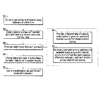
consider the local change in reflection coefficient in terms of velocity
perturbation as follows:
1
ARiii-Fi<=N = Yi)
where
ARN = 0,
22
CA 03137943 2021-10-25
WO 2020/222975
PCT/US2020/026853
yi+i represents the velocity perturbation at a time point sampled immediately
after the time
point i (after the sampling interval has passed), and yi is the velocity
perturbation at the time
point i. Thus, the local reflection coefficient change for the time point i is
proportional to its
local change in velocity perturbation. Situations where density perturbation
is identified by
the computing system 60 as non-negligible are discussed in further detail
herein.
[0069] In accordance with present embodiments, the computing system 60, in
performing the
single trace inversion process, may account for density perturbation in
certain circumstances
using a scalar based on the assumption that
tXp
a (¨Av)
where the scalar a may be chosen depending on the percentage density
perturbation in the
impedance perturbation from base to monitor. Based on the above assumption,
the scalar a is
incorporated by the computing system 60 into the objective function according
to the
following equation:
1 + a ,
ARiii-Fi<=N = __________________________ 2 Yi)
where, again, y is velocity perturbation. The circumstances where the scalar
may be
appropriate include situations where the relationship between velocity
perturbation and the
density perturbation are roughly linear.
[0070] Thus, one or more embodiments of the computing system 60 may express
the
objective function as a function of a single type of variable ¨ velocity
perturbation.
.. Accordingly, initial operations perfoimed by the computing system 60 as a
part of the single
trace inversion process of block 86 may include providing an initial estimate
of velocity
perturbations (block 88). The initial estimates may be made, for example,
based on
previously generated models (e.g., previously generated velocity models)
relating to the
23
CA 03137943 2021-10-25
WO 2020/222975
PCT/US2020/026853
subsurface region. However, present embodiments are not limited to such
methods for
estimation, and the velocity perturbations may be initially estimated by the
computing system
60 in any suitable manner.
[0071] Once the computing system 60 generates an initial estimate for velocity
perturbation
in accordance with block 88, the computing system 60 generates an initial
predicted monitor
trace, and calculates the difference 2C (or variations thereof, such as C)
according to the
objective function. In response to determining that the difference is greater
than a
convergence threshold, the computing system 60 iteratively estimates the
velocity
perturbation (block 90). The computing system 60 may perform this process
until the
difference C is below a predetermined threshold. In performing the acts of
blocks 88 and 90,
the computing system 60 may linearize a gradient associated with the objective
function
using linear interpolation to determine the manner in which the velocity
perturbations should
be changed. The performance of the linearized gradient may improve with finer
sampling
rates (e.g., 1 ms sample interval). In response to determining that the
objective function has
reached a value of C that is at or below the predetermined threshold, the
computing system
60 (performing method 80) may be considered to have produced "final" estimated
velocity
perturbations, meaning that no further iterations are required.
[0072] The computing system 60 may produce a number of different outputs using
the
velocity perturbations generated by the single trace inversion process of
block 86, for
example to aid in determining how the subsurface region may be evolving. For
instance, the
computing system 60 may utilize the output velocity perturbations to
characterize (block 92)
evolution in the subsurface region by generating a 3D map of velocity
perturbation or
velocity of the subsurface region, or by updating existing velocity,
impedance, density, or
other models. The computing system 60, for example in addition to the systems
depicted in
24
CA 03137943 2021-10-25
WO 2020/222975
PCT/US2020/026853
FIGS. 2 and/or 3, may also use the characterization as a part of the
production process (block
94).
[0073] FIG. 6 is a plot 100 of various functions that demonstrate the manner
in which the
objective function, run by the computing system 60, may be considered to
operate in the time
domain. Specifically, the plot 100 shows the functions as being plots of
various types of
values as a function of time, where negative values for each trace are shown
as being toward
the left, and positive values for each trace are shown as being toward the
right. In the plot
100, a base seismic trace 102 and a monitor seismic trace 104 corresponding to
the base
seismic trace 102 are shown as being amplitude functions of time (waveforms).
As set forth
above, the monitor seismic trace 104 corresponds to the base seismic trace 102
because the
monitor seismic trace 104 was obtained by transmitting a seismic waveform
through the
subsurface region at the same position of earth as the base seismic trace 102.
[0074] The objective function, generally, begins with the base seismic trace
102 as the
"reference" trace. A velocity perturbation function 106 is defined (e.g.,
estimated) by the
.. computing system 60, either as a series of discrete velocity perturbation
values based on
previously obtained velocity models, or may be modeled by the computing system
60 as a
function (e.g., an equation). In the example shown in FIG. 6, the velocity
perturbation
function 106 is approximated by a square wave function and is ¨A: as a
function of time. In
FIG. 6, because the base seismic trace 102 is being shifted toward (i.e.,
being transformed
toward) resembling the monitor seismic trace 104, the velocity perturbation
function 106
includes negative velocity perturbation values, which indicates that the
seismic waveform
used to generate the monitor seismic trace travels through the subsurface
region with a slower
velocity than the seismic waveform used to generate the base seismic trace.
CA 03137943 2021-10-25
WO 2020/222975
PCT/US2020/026853
[0075] The computing system 60 generates a time shift function 108 via the
objective
function based on the estimated velocity perturbation function 106. More
specifically, the
computing system 60 may generate the time shift function 108 as a scaled
summation of
velocity perturbation by the sampling rate. As shown, the time shift trends
toward a positive
value over time, meaning that the time points of the base seismic trace 102
that occur later
during the acquisition period are shifted such that they appear to have been
acquired at an
even later time. The result of applying the time shift is demonstrated by a
time-shifted base
seismic trace 110. The points of the time-shifted base seismic trace 110 are
b(EL) in the
objective function.
[0076] As set forth above, there are generally two assumed changes that occur
between the
base seismic trace 102 and the monitor seismic trace 104 ¨ a time shift (or a
change in
propagation time for the seismic wavelet used to obtain the traces) and an
amplitude change.
The amplitude change from base to monitor, which again is an estimated wavelet
convolved
with a change in reflection coefficient, is shown as an amplitude change
function 112.
However, it will be appreciated with reference to FIG. 6 that if the amplitude
change function
112 is used to modify the time-shifted base seismic trace 110, there will be a
misalignment of
a peak 114 of the trace 110 with an amplitude change peak 116 of the amplitude
change
function 112. This occurs because the peak 114 occurs at a shifted time 118,
while the
amplitude change peak 116 of the amplitude change function 112 has not been
shifted and
remains at an unshifted time 120.
[0077] Returning to FIG. 6, in accordance with present embodiments, the
computing system
60 applies the time shift function 108, via the objective function, to the
amplitude change
function 112 to generate a time-shifted amplitude change function 122.
Applying the time
shift to the amplitude change in this manner ensures that the amplitude change
is properly
.. applied to the time-shifted base seismic trace 110. The objective function
represents values
26
CA 03137943 2021-10-25
WO 2020/222975
PCT/US2020/026853
of the time-shifted amplitude change function 122 as [tp*AR(ii)]i. In this
respect, the
objective function combines the time-shifted amplitude change 122 and the time-
shifted base
seismic trace 110 to produce a predicted monitor trace 124.
[0078] It should be noted that while the present disclosure primarily relates
to the shifting of
a base seismic trace to match a corresponding monitor seismic trace, the
present disclosure is
not necessarily limited to this arrangement. In particular, the base seismic
trace is chosen as
the trace to shift largely because the base seismic volume generally has a
shallower reservoir
bottom compared to the monitor seismic volume. Indeed, it has been found that
linear
interpolation works better to calculate the inversion gradient and perform the
inversion when
a relatively fine sampling rate is used (e.g., 1 ms), and when the time shift
from velocity
perturbation will shift the reservoir bottom deeper.
[0079] As set forth above, the computing system 60 may use the estimated
velocity
perturbations produced by the single trace inversion method in a number of
ways. As one
specific example, the computing system 60 may apply the estimated velocity
perturbation to a
velocity model of the subsurface for the base survey to produce an estimated
or "updated"
velocity model of the subsurface for the monitor survey. Further, it should be
noted that the
single trace inversion methods performed by the computing system 60 may be
used not only
in situations where the time shift is small (e.g., less than 2 sampling
intervals), but also in
situations where time shifts are relatively large (e.g. 2 or more sampling
intervals). Indeed, in
situations where time shifts are relatively large, it is presently recognized
that it becomes
even more important for the computing system 60 to apply the time shift upon
the amplitude
change, in addition to applying the time shift upon the reference trace (e.g.,
the base seismic
trace).
[0080] FIGS. 7A-7C, for instance, demonstrate the accuracy of the single trace
inversion
method described herein for situations where the time shift is relatively
small. FIG. 7A
27
CA 03137943 2021-10-25
WO 2020/222975
PCT/US2020/026853
includes a true model of velocity perturbation 150 occurring between velocity
models of a
synthetic base survey and a synthetic monitor survey of a subsurface region,
where the
horizontal axis corresponds to position along a seismic block and the vertical
axis
corresponds to time. The true model of velocity perturbation 150 reflects the
actual (i.e.,
ground truth) amount of velocity perturbation between velocity models of the
synthetic base
survey and the synthetic monitor survey (i.e., an amount of velocity change
imposed between
the synthetic base survey and the synthetic monitor survey).
[0081] The velocity models were generated using the Data Dictionary System
(DDS)
input/output (I/0) system offered by BP America Inc. Such models may be
referred to as
"2D synthetics." The true model of velocity perturbation 150 includes
relatively constant
velocity changes represented by a ribbon-like shape. On the left side of the
ribbon shape,
velocity changes are a relatively constant -5%, and on the right side of the
ribbon shape,
velocity changes are a relatively constant +5%.
[0082] FIG. 7B is a raw inversion output 152 of the single trace inversion
process of one or
.. more embodiments described herein. In particular, FIG. 7B is a raw output
of the single trace
inversion process, as described for example with respect to block 86 of FIG.
5, applied to the
synthetic base survey and the synthetic monitor survey to calculate velocity
changes between
the synthetic base and monitor surveys. As shown, the raw inversion output
152, without
further processing is generally in agreement with the true model of velocity
perturbation 150.
The accuracy of the present embodiments may be further appreciated with
reference to FIG,
7C, which is a regularized inversion output 154 corresponding to
regularization applied to the
raw inversion output 152. As shown in FIG. 7C, the modeled velocity
perturbations are in
further agreement with the true model of velocity perturbation 150 after
artifacts are removed
via regularization.
28
CA 03137943 2021-10-25
WO 2020/222975
PCT/US2020/026853
[0083] FIGS. 8A and 8B depict velocity change models for base and monitor
synthetics
generated in a similar manner as described above with respect to FIGS. 7A-7C.
More
specifically, FIGS. 8A and 8B provide a visual comparison of inversion results
when a time
shift is not applied to the amplitude change of the objective function
(corresponding to an
unshifted inversion output 160 as shown in FIG. 8A) versus when a time shift
is applied to
the amplitude change of the objective function (corresponding to a shifted
inversion output
162 as shown in FIG. 8B). As shown, when the time shift from base to monitor
is relatively
large (e.g., 2 or more sampling intervals), significant error is introduced to
the model when a
time-shift is not applied to the amplitude change. Both models are shown
without
.. regularization, and it was determined that the shifted inversion output 162
has the same
reservoir thickness in time as the real model.
[0084] As set forth above, in certain embodiments it may be assumed that, for
the purposes
of performing the single trace inversion process of the present disclosure,
density
perturbation is negligible because velocity perturbation is the main change in
the reservoir
from base to monitor. As one example, if, as a result of hydrocarbon
production, there is a
relatively small amount of gas coming out of solution, the predominant change
will be in
velocity. However, in other cases, density perturbation will have a non-
negligible effect.
Indeed, it is now recognized that the percentage error in impedance
perturbation estimation
increases exponentially with the percentage contribution of density
perturbation to impedance
perturbation. Accordingly, as previously described, the computing system 60
may account
for the density perturbation using the scalar a, which may be chosen depending
on the
percentage density perturbation in the impedance perturbation from base to
monitor. The
circumstances where the scalar may be appropriate include situations where the
relationship
between velocity perturbation and the density perturbation are roughly linear.
29
CA 03137943 2021-10-25
WO 2020/222975
PCT/US2020/026853
[0085] FIG. 9 is an example plot 170 of how the materials in a fottnation may
affect density
and velocity perturbation, and their relationship, for an example reservoir.
As shown in FIG.
9, there are a number of scenarios shown in the legend that serve as examples
of processes
that may be observed between the time when the base and monitor surveys are
performed.
Specifically, the legend includes a first scenario 172, a second scenario 174,
a third scenario
176, a fourth scenario 178, a fifth scenario 180, a sixth scenario 182, a
seventh scenario 184,
and an eighth scenario 186. These scenarios are accompanied by example water,
oil, and/or
gas saturation values (Sw, So, and Sg, respectively). It should be noted that
in the example
plot 170 of FIG. 9, it is assumed that pressure remains relatively constant.
100861 The four quadrants depicted in the plot 170 are divided according to
the presence of
gas, and whether water or gas is being injected. Specifically, with respect to
the presence of
gas in the reservoir, a first trend line 188 corresponds to no gas being
present in the reservoir,
and a second trend line 190 corresponds to gas being present in the reservoir.
The first and
second trend lines 188, 190 correspond to positive velocity perturbation
values and negative
velocity perturbation values, respectively. With respect to fluid injection
into the reservoir, a
third trend line 192 corresponds to the injection of water into the reservoir,
and a fourth trend
line 194 corresponds to the injection of gas into the reservoir. The third and
fourth trend lines
192, 194 correspond to positive density perturbation values and negative
density perturbation
values, respectively.
[0087] For the first, second, third, and eighth scenarios 172, 174, 176, 186,
the density
increases as water is introduced, and the velocity perturbation is negative
because the
impedance change is largely determined by the density change. More
specifically, the fluid
bulk modulus, K. is mostly determined by the gas bulk modulus, and the p-wave
velocity Vp
relates to the fluid bulk modulus according to the following equation:
CA 03137943 2021-10-25
WO 2020/222975
PCT/US2020/026853
K 5
Vp = (¨)
where K will generally not change by an appreciable amount, but because the
density p
increases, the fluid Vp will decrease. The rock Vp will also decrease
accordingly ¨ with the
decrease in Vp leading to a negative velocity perturbation.
[0088] FIG. 10 provides example inversion results produced by the objective
function when
the density perturbation accounts for 60% of the impedance perturbation. More
specifically,
the left diagram is a set of first inversion results 200, and demonstrates
that when the
computing system 60 does not use the scalar a to account for density
perturbation, there is
clearly error in both the velocity perturbation and the time shift produced by
the objective
function. However, when the computing system 60 applies the appropriate value
for the
scalar a, in this example a value of 1.5, the velocity perturbation and time
shift inversion
results are clearly more precise as shown in the set of second inversion
results 202.
[0089] In this respect, the 4D joint inversion process performed by the
computing system 60
may be considered an "adaptive" technique by incorporating the ability to
adjust the scalar
parameter to account for varying degrees of density perturbation without
incorporating an
additional variable into the objective function. Example values for the scalar
are presented in
Table 1 below.
[0090] According to the embodiment of Table 1, the three zones of a velocity
perturbation
(dv/v) and density perturbation (dp/p) crossplot, such as the crossplot shown
in FIG. 9, are
equally divided according to angle. The values of alpha corresponding to
angles below 180
degrees would be used in a pool for inversion. It should be noted that certain
of the values
are outliers. For example, the values at 90 degrees and 270 degrees are not
realistic, and the
value at 180 degrees corresponds to negligible contribution from density
perturbation.
31
CA 03137943 2021-10-25
WO 2020/222975
PCT/US2020/026853
Table 1. Example values for a
Angle (Degree) , dp/p dv/v a
0 . 0 1 0.00
0.173648175 0.984807754 0.18
_
0.342020138 0.939692623 0.36
_
0.499999992 0.866025408 0.58
0.642787601 0.766044451 0.84
0.766044434 0.642787621 1.19
0.866025395 0.500000015 1.73
0.939692614 0.342020163 2.75
0.984807749 0.173648201 5.67
1 2.67949E-08
100 0.984807758 -0.173648148 -5,67
110 0.939692632 -0.342020113 -2.75
120 0.866025422 -0.499999969 -1,73
130 0.766044468 -0.64278758 -1.19
140 0.642787642 -0.766044416 -0.84
150 0.500000039 -0.866025381 -0.58
160 0.342020188 -0.939692604 -0.36
170 . 0.173648228 -0.984807744 -0.18
180 5.35898E-08 -1 0.00
_
190 -0.173648122 -0.984807763 0.18
200 -0.342020087 -0.939692641 0.36
210 -0.499999946 -0.866025435 0.58
220 -0.64278756 -0.766044485 0.84
230 -0.766044399 -0.642787662 1.19
240 -0.866025368 -0.500000062 1.73
250 -0.939692595 -0.342020213 2.75
260 -0.98480774 -0.173648254 5.67
270 -1 -8.03847E-08
32
100911 The specific embodiments described above have been shown by way of
example, and
it should be understood that these embodiments may be susceptible to various
modifications
and alternative forms. It should be further understood that the claims are not
intended to be
limited to the particular forms disclosed, but rather to cover all
modifications, equivalents,
and alternatives falling within the spirit and scope of this disclosure,
100921 The techniques presented and claimed herein are referenced and applied
to material
objects and concrete examples of a practical nature that demonstrably improve
the present
technical field and, as such, are not abstract, intangible or purely
theoretical.
33
Date recue/Date received 2023-04-21