Note: Descriptions are shown in the official language in which they were submitted.
AIRBORNE TOPO-BATHY LIDAR SYSTEM AND METHODS THEREOF
CROSS-REFERENCE TO RELATED APPLICATION
[0001] This application claims the benefit of U.S. provisional patent
application Serial No.
62/854,571, filed on May 30, 2019, entitled Airborne Topo-Bathy LiDAR SYSTEM
and Methods
Thereof.
STATEMENT REGARDING FEDERALLY SPONSORED RESEARCH OR
DEVELOPMENT
[0002] This invention was made with government support under contract
W9127817D0068 awarded by the U.S. Army Corps of Engineers. The government has
certain
rights in the invention.
BACKGROUND
[0003] Airborne LiDAR instruments scan a pulsed laser to collect ranging
measurements
of the distance to the ground. When combined with position and altitude
obtained from integrated
GPS receivers and Inertial Measurement Units, detailed elevation mapping
products are generated.
LiDAR is a mature technology that is routinely used for aerial topographic
surveys. Current
advancements in aerial LiDAR technology have led to increased collection
rates, higher mapping
densities, and higher operational altitudes. State-of-the-art systems record
millions of elevation
measurements per second and operate at altitudes over 7000 meters. While
topographic LiDAR
systems are capable of these specifications, bathymetric LiDAR systems
designed to survey the
seafloor record elevations at much lower rates in the kHz range, and operate
at much lower
altitudes in the 200-500 meter range.
BRIEF DESCRIPTION OF THE DRAWING
1
Date Recue/Date Received 2024-03-20
CA 03139818 2021-11-09
WO 2020/251787 PCT/US2020/035454
[0004] Various embodiments will become better understood with regard to
the following
description, appended claims and accompanying drawings wherein:
[0005] FIG. 1 is a side view of an airborne LiDAR bathymetry (ALB) system
in
accordance with one non-limiting embodiment.
[0006] FIG. 2 is a front view of the ALB system of FIG. 1.
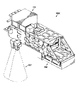
[0007] FIG. 3 is an isometric view of the ALB system of FIG. 1.
[0008] FIG. 4 schematically illustrates an example ALB system being
transported by an
aircraft for data collection.
[0009] FIGS. 5-7 depict an example optical design of an example receiver
system in
accordance with the present disclosure.
[0010] FIG. 8 depicts a cutaway isometric view of a portion of the
receiver system of FIGS.
5-7.
[0011] FIG. 9 depicts example optical paths through the example ALB
system of FIG. 1.
[0012] FIG. 10 depicts an example detector system in accordance with one
non-limiting
embodiment.
[0013] FIG. 11 depicts an isometric view of the detector system of FIG.
10 with
components removed for clarity.
[0014] FIG. 12 depicts an examiner refounatter coupled to a Geiger mode
array detector.
[0015] FIG. 13 schematically illustrates the optical path of the
reformatter of FIG. 12.
[0016] FIG. 14 depicts the conversion of a 2x2 input image to a
rectangular 1x4 output
image by a reformatter in accordance with one embodiment.
[0017] FIG. 15 depicts a side view of an example laser transmission
system in accordance
with a non-limiting embodiment.
2
CA 03139818 2021-11-09
WO 2020/251787 PCT/US2020/035454
[0018] FIG. 16 depicts a top view of the laser transmission system of
FIG. 15.
[0019] FIG. 17 is an isometric view of a laser transmitter module in
accordance with one
non-limiting embodiment.
[0020] FIG. 18 is a cross-sectional isometric view of a galvo enclosure
in accordance with
one non-limiting embodiment.
DETAILED DESCRIPTION
[0021] Various non-limiting embodiments of the present disclosure will
now be described
to provide an overall understanding of the principles of the structure,
function, and use of a high
altitude topo-bathy LiDAR system as disclosed herein. One or more examples of
these non-
limiting embodiments are illustrated in the accompanying drawings. Those of
ordinary skill in the
art will understand that systems and methods specifically described herein and
illustrated in the
accompanying drawings are non-limiting embodiments. The features illustrated
or described in
connection with one non-limiting embodiment may be combined with the features
of other non-
limiting embodiments. Such modifications and variations are intended to be
included within the
scope of the present disclosure.
[0022] Reference throughout the specification to "various embodiments,"
"some
embodiments," "one embodiment," "some example embodiments," "one example
embodiment,"
or "an embodiment" means that a particular feature, structure, or
characteristic described in
connection with any embodiment is included in at least one embodiment. Thus,
appearances of the
phrases "in various embodiments," "in some embodiments," "in one embodiment,"
"some example
embodiments," "one example embodiment, or "in an embodiment" in places
throughout the
specification are not necessarily all referring to the same embodiment.
Furthermore, the particular
3
CA 03139818 2021-11-09
WO 2020/251787 PCT/US2020/035454
features, structures or characteristics may be combined in any suitable manner
in one or more
embodiments.
[0023] Throughout this disclosure, references to components or modules
generally refer to
items that logically can be grouped together to perform a function or group of
related functions.
Like reference numerals are generally intended to refer to the same or similar
components.
Components and modules can be implemented in software, hardware, or a
combination of software
and hardware. The term software is used expansively to include not only
executable code, but also
data structures, data stores, and computing instructions in any electronic
format, firmware, and
embedded software. The terms information and data are used expansively and can
include a wide
variety of electronic information, including but not limited to machine-
executable or machine-
interpretable instructions; content such as text, video data, and audio data,
among others; and
various codes or flags. The terms information, data, and content are sometimes
used
interchangeably when permitted by context.
[0024] The examples discussed herein are examples only and are provided
to assist in the
explanation of the systems and methods described herein. None of the features
or components
shown in the drawings or discussed below should be taken as mandatory for any
specific
implementation of any of these systems and methods unless specifically
designated as mandatory.
For ease of reading and clarity, certain components, modules, or methods may
be described solely
in connection with a specific figure. Any failure to specifically describe a
combination or sub-
combination of components should not be understood as an indication that any
combination or
sub-combination is not possible. Also, for any methods described, regardless
of whether the
method is described in conjunction with a flow diagram, it should be
understood that unless
otherwise specified or required by context, any explicit or implicit ordering
of steps performed in
4
CA 03139818 2021-11-09
WO 2020/251787 PCT/US2020/035454
the execution of a method does not imply that those steps must be performed in
the order presented
but instead may be performed in a different order or in parallel.
[0025] Airborne LiDAR bathymetry (ALB) is an established and effective
technique for
measuring depths of coastal waters. Pioneering work by Guenther led to the
development of the
first ALB systems in the 1980s. The basic principle of LiDAR bathymetry is to
record
measurements from a scanned, pulsed, water penetrating green laser. A green
laser is used for sea
bottom detection because blue-green wavelengths penetrate typical coastal
waters with the least
attenuation. Once the surface of the water is detected the distance to the
seafloor is calculated from
the time difference and knowledge of the speed of light in both air and water.
The speed of light
in water is roughly a third slower than in air and this bias must be
corrected. Thus accurate
determination of ranging distance is dependent on reliable detection of both
the water surface and
the sea floor from the waveform of the laser return pulse.
[0026] The waveform of the received green laser pulse is the
superposition of a number of
effects including interaction of the laser pulse at the air-water interface,
volume scattering as the
laser traverses the water column, and reflection of the laser at the seafloor.
At the air-water
interface on both the transmit path and the receive path, a portion of the
energy of the laser pulse
is reflected and the remaining energy is transmitted as determined by the
Fresnel equations. For
an ideally level sea surface the one-way Fresnel reflection is 2-3% for
typical ALB off-nadir laser
beam angles. However, the sea surface is never flat and even at low wind
speeds the reflectance
of water is treated as a rough surface and typically modeled using a micro-
faceted bidirectional
reflectance distribution function (BRDF). The BRDF includes both a diffuse
component and a
specular lobe that increases in amplitude with water surface roughness which
in turn is modeled
as a function of wind speed. As the laser pulse travels through the water
column, volume scattering
CA 03139818 2021-11-09
WO 2020/251787 PCT/US2020/035454
and absorption attenuate the laser energy. A portion of the scattering is
reflected back along the
receive path. This backscatter is also a component of the received LiDAR
wavefolin. The third
component of the laser waveform is the bottom return from the diffuse
reflection of the seafloor
of the attenuated laser light. Once attenuation results in a bottom return
with magnitude below the
noise threshold and/or the backscatter return, bottom detection is no longer
possible. Refraction at
the air-water interface and multiple scattering result in a stretched pulse
return from the bottom. In
the presence of all of these effects, detecting and localizing the sea-floor
bottom is a challenging
signal processing task.
[0027] In addition to the green waveform return, bathymetric systems also
may take
advantage of the red shifted laser return that results from Raman backscatter
of the green laser in
the water column. Detection of this signal can aid in the determination of the
water surface due to
the fact that Raman scattering is minimally affected by wind speed and sea
surface waves. Some
bathymetric and topo-bathy systems also employ an IR laser which does not
penetrate the water
but provides reliable detection of the water surface in addition to
topographic measurements.
[0028] Although some laser energy is lost from the Fresnel reflection at
the air-water
interface, the dominant effect of laser attenuation is the scattering and
absorption of light along the
water column. The transmittance of light in water is governed by the Beer-
Lambert law which
follows an exponential decay and is expressed as:
E (z) = Eoe(-Kdz)
where E (z) is the irradiance at depth z, and E0 is the irradiance at the
water surface. The term Kd
is the diffuse attenuation coefficient and, in the field of ocean optics, is a
well-studied apparent
optical property of water. The diffuse attenuation coefficient varies with
water clarity, and it is an
6
CA 03139818 2021-11-09
WO 2020/251787 PCT/US2020/035454
indicator of the forward transmission of radiation in water. The diffuse
attenuation coefficient is
defined as:
1 dEd
--
Ed dz
where the term Ed is the planar down-welling irradiance. The value of Kd
varies with wavelength,
and for coastal water has a minimum near 532 nm which corresponds to the
wavelength of many
common frequency doubled, solid-state Nd:YAG lasers. For typical clear coastal
waters Kd =
0.1m-1 while murky, near-shore waters have a coefficient closer to Kd = 0.4m-
1.
[0029] To mitigate the effects of laser attenuation and penetrate coastal
waters, most ALB
systems use a high power green laser. Typical laser power per pulse for ALB
systems is around 5
mJ as compared to typical topographic systems which are on the order of 100
uJ. The receiver's
aperture size can also be increased to gather more light; however,
difficulties in manufacturing
large telescope mirrors, instrument size, and platform constraints place
limits on increasing
aperture size. Additionally, keeping system electronic noise to a minimum and
improving detector
sensitivity can increase the depth penetration of the LiDAR. Operational
altitude has a
considerable impact on water penetration due to the inverse square law
relating the received laser
power to the transmitted laser power. For this reason ALB systems operate at
low altitudes in the
range of 200-500 meters above the water. For a variety of reasons, further
reducing altitude is
difficult and would lead to an unacceptably small swath. Unlike topographic
LiDAR a wide
scanning angle with a large off-nadir beam angle is not practical for ALB.
[0030] The depth penetration capability of an ALB system is typically
expressed as cimaõ =
n/Kd. A well designed ALB instrument will have a value for n in the range of 2-
4 for daytime
operation and 3-5 for night time operation. For example, a system with dm ax=
4/Kd would be
able to penetrate 40m in typical coastal waters where Kd = 0.1m-1. Note that
even if sufficient
7
CA 03139818 2021-11-09
WO 2020/251787 PCT/US2020/035454
laser light reaches the sea bottom, the albedo, or reflectance, of the
seafloor has a considerable
impact on the ability of an ALB system to resolve the bottom from a waveform.
[0031] In addition to the attenuation of light, water alters the off-
nadir angle of the laser
beam via refraction. Although correcting for refraction is a straightforward
application of Snell's
Law, depending on the level of accuracy required it may be necessary to
carefully model surface
waves. Another challenge in LiDAR bathymetry is to disambiguate the water
surface from the
bottom in very shallow waters where the surface and bottom return merge. To
this end a short
pulse width laser is helpful as are high-bandwidth, low-noise receiver
electronics which yield a
narrow system transfer function in the spatial domain.
[0032] Laser, telescope, scanner, detector, and GPS/IMU are the primary
components of a
LiDAR mapping system. Bathymetric and topo-bathy systems have specific
requirements for most
of these components. Bathy systems typically use a high powered, frequency
doubled, solid state
Nd:YAG laser. As compared to topographic systems these lasers are operated at
a much lower
pulse rate. The combination of high power ¨30W and low pulse rate ¨10 kHz
results in laser pulse
energies on the order of 3 mJ which are needed for water penetration. To
improve surface and
bottom detection, and to minimize the effects of pulse stretching, short laser
pulses of a few ns or
less are used. IR lasers are often used in conjunction with green lasers to
aid in surface detection
and provide topographic measurements. Frequency doubled lasers can be used to
emit aligned IR
(1064 nm) and green (532 nm) beams.
[0033] The telescopes in ALB systems use large apertures to gather more
light, which in
turn requires a large diameter scanner. Due to the effects of refraction and
the high variability of
surface returns as function of the angle of incidence, most ALB systems use a
scanner with a fixed
or narrow range of off-nadir beam angles, typically around 15-20 degrees.
Linear scan patterns are
8
CA 03139818 2021-11-09
WO 2020/251787 PCT/US2020/035454
avoided in favor of circular, semi-circular, or elliptical scan patterns.
Nutating mirrors, Risley
prisms, wedge prisms, and Fresnel prisms can be used to design scanners with
these patterns.
[0034] Photomultiplier tubes (PMT) are often chosen as detectors in order
to handle the
large dynamic range of bathymetric returns. PMTs are able to maintain a linear
response over
several orders of magnitude. Despite the high dynamic range of PMTs, care must
be taken to avoid
after-pulsing and possible detector damage from high energy returns. Another
common ALB
detector design is the use of multiple channels to either segment the field of
view spatially or to
increase dynamic range via beam splitters.
[0035] The high power lasers used in ALB systems require significant
cooling. The need
for thellnal management in addition to the large telescopes and scanners can
place constraints on
Size, Weight and Power (SWaP). Designing low power and smaller footprint
systems is one of the
coming challenges of future bathymetric LiDAR systems.
[0036] High altitude bathymetry has challenges. Currently, operational
and commercially
available ALB systems operate at low altitudes in the range of 200m-500m. This
is far below the
altitudes of topographic LiDAR systems, which routinely operate in the range
of 1500m-3500m
or higher. Increasing the operational altitude of ALB systems to 3000m
presents several
challenges that require novel approaches. The primary difficulty is the loss
of laser power from
the inverse square law and atmospheric attenuation. From the LiDAR equation
Pr PtCL¨h2 T (h; .1)
where Pr is the received optical power, Pt is the transmitted optical power,
and CI is the LiDAR
constant that depends only on the physical properties of the sensor, the
received optical power falls
by ¨ where his the altitude. This inverse square fall-off is derived from the
decreasing solid angle
that is subtended by the aperture of the telescope as altitude is increased.
The received optical
9
CA 03139818 2021-11-09
WO 2020/251787 PCT/US2020/035454
power is further attenuated by T, the two-way atmospheric transmission
attenuation factor which
depends on A, the laser wavelength. In the visible wavelengths, T is mostly
due to Rayleigh
scattering in the atmosphere. Bathymetric systems, which require a green
laser, suffer from greater
attenuation than IR based topographic systems due to the spectral dependence
of Rayleigh
scattering.
[0037] To scale an existing ALB design from operating at 500m to 3000m
would require
a 36x increase in laser power to account for the loss of energy from.
Atmospheric attenuation of
laser power at 532nm on a clear day is around 0.85 at an altitude of 3km,
while attenuation at 500m
is approximately 0.97. Combined with the inverse square fall-off, a 40x
increase in laser power is
required to scale an existing design. Given the high power lasers -greater
than 10W- that are used
in ALB systems at 500m, a 40 fold increase is not a feasible solution.
[0038] Another challenge is the need to maintain point density as
altitude is increased.
Moving from 500m to 3000m requires a 6 fold increase in measurement rate to
maintain point
density. This can be accomplished by increasing the pulse rate of the laser,
increasing the number
of lasers, and/or using an arrayed detector to increase the number of receiver
channels. To maintain
pulse energy per receiver channel a corresponding 6x increase in total laser
power is needed. This
would require kWs of laser power to maintain depth penetration and point
density at high altitude
using conventional detector and laser technology.
[0039] Maintaining geo-location accuracy is another difficulty when
designing high
altitude systems. As altitude is increased angular pointing errors and biases
are magnified. For
topographic LiDAR systems biases can be calibrated and angular pointing errors
reduced in
software during post-processing. Existing commercial software packages are
designed for
CA 03139818 2021-11-09
WO 2020/251787 PCT/US2020/035454
topographic LiDAR and cannot be leveraged. New methods for calibrating biases
and improving
pointing accuracy for bathymetric point clouds are needed.
[0040] With practical limits on laser power, a high altitude ALB system
must rely on
specialized detector technology. In addition, scanner design and post-
processing are important
criteria for developing a solution to high altitude bathymetry.
[0041] Due to their ability to detect weak optical signals, both
photomultiplier tubes (PMT)
and avalanche photodiodes (APD) are commonly used detectors in LiDAR systems.
Typically
these devices are operated in analogue mode and used to measure the waveform
of the received
laser pulse. For ALB where a high dynamic range is needed, the PMT is the
detector of choice.
On the other hand, most topographic systems employ APDs.
[0042] PMTs can be used to detect very faint signals down to a single
photon; however,
they require an external power source with high voltage. When APDs are
operated with a bias
above the breakdown voltage, in so called Geiger mode, they are also capable
of detecting single
photons and are referred to as single-photon avalanche diodes (SPAD) or Geiger
mode APD (G-
APD). Both SPAD and PMT detectors are suited for signal detection in photon
starved
environments such as high altitude bathymetric LiDAR.
[0043] One of the drawbacks of SPAD detectors is the long recovery time.
Following
detection of a photon a channel must be quenched before it is ready to detect
a new photon.
Passively quenched detectors can have recovery times as much as 1 msec while
actively quenched
detectors are around 50 nsec. PMTs are much faster with recovery times < 2
nsec. For a water
penetrating ALB system, recovery time is an important specification for
detector selection.
Depending on the arrival rate of backscattered photons from the water column
and the recovery
time of the detector, backscatter in the water column could prevent bottom
detection.
11
CA 03139818 2021-11-09
WO 2020/251787 PCT/US2020/035454
100441 SPAD detectors can be arranged in a two-dimensional monolithic
array; chips
containing a 32 x 32 or 32 x 128 array of SPAD detectors are commercially
available. Arrayed
PMT detectors can also be designed using a micro-channel plate (MCP). These
MCP-PMT
detectors are offered in a 10 x 10 channel array by Hamamatsu Inc. In addition
to single photon
detection with good quantum efficiency at 532 nm, these detectors provide
spatial resolution.
Arrayed detectors offer advantages for high altitude ALB both in terms of
increased point density
and improvements in geo-location via post-processing. The fact that each pixel
in the array shares
the same position, attitude, and timing errors can be leveraged to develop
algorithms for geo-
location accuracy enhancement.
100451 Using a single photon sensitive detector, both water penetration
and high altitude
operations can be achieved with existing laser technology. The number of
received photons is
given by the equation:
EC = T(h; A)Arpe
=
(A)h2n-
where Et is the energy per laser pulse, C is the efficiency of the LiDAR
system, T(h; A) is the
two-way atmospheric attenuation at the slant range h and the wavelength A, (A)
is the energy
per photon, Ar is the aperture receiver area, and pe is the effective albedo
of the seafloor after
two-way attenuation by the water column. At wavelength 532 nm, (A) = 3.734 X
10' J.
Using nominal values C = 0.1, T = 0.85, and Ar = 0.015 m2 and a slant range of
h = 3100 m
the photon count is AT, = Et = 1.13 X 10⁸pe. The effective albedo of the
seafloor is dependent on
z the water depth, pbthe actual albedo of the seafloor bottom, Kd the diffuse
attenuation
coefficient, and FT the Fresnel reflection at the water surface, and is
described by the equation
Pe = Pbe(-2K d) (l Fr).
12
CA 03139818 2021-11-09
WO 2020/251787 PCT/US2020/035454
For the case of a sandy bottom with reflectance Pb = 0.4, a clear coastal
water with Kd
0.1m-', and a Fresnel reflection of Fr. = 0.03, to receive on average a single
photon from a
depth of z = 20m requires a laser pulse with energy Et = 1 p..T. Although more
than a single
photon is needed for a high probability of detection, from Poisson statistics,
as few as 3 photons
is sufficient. For seafloor detection over a range of water clarity, bottom
reflectance values, and
LiDAR system efficiencies, energy per pulse and per channel on the order of 10
[tJ is sufficient
for designing a high altitude ALB system. ALB systems typically take
bathymetric
measurements at the rate of 10-30 kHz. After accounting for the increased
measurement rate
needed for high altitude operation, the total laser power is < 10W.
[0046] Another important design criterion for an ALB system is
maintaining a constant
off-nadir laser beam angle. There are many effective ways to achieve a
constant off-nadir scan
angle, including passing a nadir pointing laser beam through a rotating wedge,
Fresnel prism or
leveraging multiple scanning mirrors.. The design of the prism can be selected
once an optimal
off-nadir angle is determined. The circular scan pattern that is generated
from a rotating prism, or
orthogonal sinusoidal scan mirrors, is also well suited to an arrayed
detector. When used with an
arrayed detector, contiguous mapping can be maintained at relatively low scan
speeds. In addition,
with a circular scan pattern objects are scanned at least twice, from
different look angles, which is
beneficial for certain applications such as object detection and
identification. As previously
mentioned the circular pattern is also leveraged for calibration and improved
geo-location. Both
ALB systems, such as CZM1L, and high altitude topographic LiDAR systems, such
as AL1RT and
Buckeye-II, use circular scan patterns.
[0047] One of the key differences between single photon detectors and
waveform detectors
is the processing of the data. Because a single photon is indistinguishable
from noise, data from
13
these detectors requires heavy processing. The processing is often non local
and best done in the
point cloud to make optimal use of the data. Data from single photon detectors
contains noise from
non-laser illumination sources such as solar radiance. Due to the high
sensitivity of these devices,
they also contain considerable amounts of system noise including cross-talk,
after-pulsing, and
Gaussian noise. Unlike linear mode detectors, which produce a waveform that
can be analyzed to
determine the leading edge or peak, a single photon cannot be accurately
located within the
received laser pulse without analyzing a neighborhood of points. However, with
the selection of
appropriate data structures and pattern recognition algorithms these noise
sources can be
efficiently removed and/or reduced.
[0048] Point cloud processing algorithms can also be applied to detect the
water surface,
filter the backscatter from the water column, and detect the seafloor returns.
Unlike waveform
processing which is typically performed independently for each laser pulse,
point cloud algorithms
integrate measurements from multiple neighboring laser pulses. For problems
such as water
surface detection from a green only laser system and bottom detection with
sparse returns this
methodology is advantageous.
[0049] In summary, by leveraging recent advances in high altitude
topographic LiDAR
systems, including single photon detectors, arrayed detectors, circularly
scanning systems, and
point cloud processing algorithms, ALB systems in accordance with the present
disclosure can
operate at much higher altitude than existing systems. Example embodiments of
these topo-bathy
LiDAR systems are capable of more efficient coverage with greater point
density, and can generate
both topography and bathymetry in a single pass.
[0050] Each of the following references are referenced herein: (1) Meeting
the accuracy
challenge in airborne LiDAR bathymetry. Guenther, Gary C. 2000. Proceedings of
EARSeL-SIG-
14
Date Recue/Date Received 2024-03-20
Workshop LIDAR, Dresden/FRG; (2) Mobley C., et al. Ocean Optics Web Book.
Ocean Optics
Web Book. http://www.oceanopticsbook.info/; (3) Impact of Receiver Deadtime on
Photon-
Counting SLR and Altimetry during Daylight Operations. J., Degnan J. 2014.
Proceedings of the
16th International Workshop on Laser Ranging; and (4) Two-Dimensional SPAD
Imaging Camera
for Photon Counting. Guerrieri F, Tisa S. Tosi A., Zappa F. 5, s.l. : IEEE,
2010, IEEE Photonics
Journal, Vol. 2.
100511 Details of an example optical design of a high altitude topo-bathy
LiDAR system
in accordance the present disclosure are provided below with reference to
FIGS. 1-18. Those of
ordinary skill in the art will understand that the systems and methods
thereof, specifically described
herein and illustrated in the accompanying drawings, are non-limiting
embodiments.
100521 Referring now to FIGS. 1-3, an example high-altitude ALB system
1000 in
accordance with the present disclosure is depicted. FIG. 1 is a side view of
the ALB system 1000,
FIG. 2 is a front view of the ALB system 1000, and FIG. 3 is an isometric view
of the ALB system
1000. The ALB system 1000 can be mounted to an aircraft to collect topographic
and bathymetric
data from an altitude of around 10,000 feet, for example. In some embodiments,
the ALB system
1000 is mounted to a Reims-Cessna F406 Caravan II aircraft and flown at about
160 knots, but
this disclosure is not so limited. In other embodiments, for example, an
unmanned aerial vehicle
(UAV) or other suitable aircraft can be used. FIG. 4 schematically illustrates
the ALB system
1000 of FIGS. 1-3 being transported by an aircraft 1002. The aircraft 1002 can
be flying at an
altitude (A) of about 10,000 feet, for example, and traveling at a velocity
(V) of about 160 knots,
for example. As schematically indicated by data collection cone 1008, the ALB
system 1000 can
be used to map both topographic surfaces 1004 and underwater surfaces 1006.
Date Recue/Date Received 2024-03-20
CA 03139818 2021-11-09
WO 2020/251787 PCT/US2020/035454
[0053] The ALB system 1000 in accordance with the present disclosure can
have a water
depth penetration in the range of about 0 to about 30 meters depending on
water clarity, with about
0 to about 10 meters of water depth penetration having approximately 1 meter
spatial resolution
and about 10 to about 30 meters of water depth penetration having a spatial
resolution of about 2.5
meters. In accordance with various embodiments, the topographic resolution is
about 0.5 meters.
When flown at altitude, the ALB system 1000 can have a swath width of about
850 meters. The
ALB system 1000 can include various sub-systems or components, which are
described in more
detail below. For example, the ALB system 1000 can include a receiver system
100, a detector
system 110, and a laser transmission system 200. Generally, the laser
transmission system 200
can transmit laser pulses at two different wavelengths (schematically
illustrated by laser pulses
202) to illuminate an area on the ground that is aligned with the field of
view of the receiver system
100.
[0054] As depicted in FIGS. 5-7, an example optical design of the
receiver system 100 of
the ALB system 1000 in accordance with an embodiment of the present disclosure
is depicted.
Furthermore, FIG. 8 depicts a cutaway isometric view of a portion of the
receiver system 100
illustrated in FIGS. 5-7. Referring first to FIG. 5, the optical design can
generally include an
objective 102, a reflective aperture relay (RAR) 104, a down-collimating
telescope 108, and a
detector system 110, each of which are described in more detail below. The
receiver system can
also include a scanning sub-system, which can include a scanning wobble mirror
106.
[0055] The objective 102 can be designed to collect and focus returned
light 152 from a
point on the ground that is about 10,000 feet away and at an angle of 8
degrees off the optical axis,
for example. The 8 degree off-nadir angle can be swept in a circle with the
scanning wobble mirror
106 that is rotating within the receiver system 100, as shown. The RAR 104 can
be positioned
16
CA 03139818 2021-11-09
WO 2020/251787 PCT/US2020/035454
downstream of a spider-window 132. The purpose of the RAR 104 can be two-fold.
A primary
purpose for the RAR 104 is to produce an image of the aperture of the
objective to the scanning
wobble mirror 106. A secondary purpose of the RAR 104 is to correct some of
the optical
aberrations that are produced by the objective 102. The light from the RAR 104
can be directed to
the scanning wobble mirror 106. The scanning wobble mirror 106 is located on
the optical axis of
the receiver system 100 and is used to collect the light that is precessing at
8 degrees and return it
to being parallel to the axis of the optical system. The light leaving the
scanning wobble mirror
106 is mostly collimated. After the beam is collimated and redirected to be on-
axis, the beam
diameter can be reduced with the down-collimating telescope, described in more
detail below. A
fold mirror can be utilized to reflect the beam out of the main body of the
telescope. The beam
leaving the down-collimating telescope (DCT) 108 is mostly collimated as it
enters the detector
system 110. The detector system 110 can have an array of 5 detectors, for
example. Each detector
can operate at a single wavelength. The wavelengths are separated using
dichroic beamsplitters.
The energy going to the individual detectors is controlled through neutral
beamsplitters.
Additional description regarding the detector 110 can be found below with
reference to FIGS. 10-
11.
100561 As depicted in FIG. 6, the objective 102 in the system can be
composed of three
glass elements 122, 124, and 126, for example. The three elements 122, 124,
and 126 can provide
color correction and can control the aberrations in the system to a level
where the downstream
optical components can be utilized to correct them. The front element 122 in
the objective 102 can
have one surface designed to be aspheric. The remaining elements 124 and 126
can be spherical.
The aspherical surface of the front element 122 can be used to control the
amount of spherical
aberration in the system. The aberrations that are not well controlled through
the objective can be
17
CA 03139818 2021-11-09
WO 2020/251787 PCT/US2020/035454
coma and astigmatism. In accordance with various embodiments, the diameter of
the collected
light beam can be 300 mm and the focal length of the objective alone can be
965 mm. The f-stop
of the objective can be f/3.2, for example. Minimizing the aberrations in each
part of the system
can allow for looser alignment tolerances between components. The two mirrors
134 and 136 in
the RAR 104 can both be aspheric. The beam-path from the objective 102 can be
folded with a
fold mirror 128 that is flat that serves to shorten the overall length of the
system. The fold mirror
128 can be considered to be part of the objective 102 in accordance with
various embodiments.
[0057] As shown in FIG. 7, after the fold mirror 128, the light passes
through the spider-
window 132, which generally is a thick window. In some embodiments, for
example, the spider-
window 132 is about 30 mm thick. After the spider-window 132 is the RAR 104.
The RAR 104
can include two curved mirrors, a primary mirror 134 and a secondary mirror
136, for example.
The light from the objective 102 can come to a focus between the first and
second mirrors 134 and
136. It can be required that the light go through focus to allow the aperture
of the objective 102 to
be imaged to the scanning wobble mirror 106. Imaging of the aperture of the
objective 102 to the
scanning wobble mirror 106 can be required to simplify the mapping of the
images from the
sensors to the ground.
100581 Still referring to FIG. 7, the scanning wobble mirror 106 can have
a toroidal surface
that is rotated about the optical axis of the system by a motor 107. Bearings
109 can facilitate
rotation of the scanning wobble mirror 106 and its assembly about the optical
axis. The tilt angle
of the scanning wobble mirror 106 can be, for example, 16.654 degrees with
respect to the optical
axis of the system. The included angle between the input and output beams at
the scanning wobble
mirror 106 is different from the 8 degree angle at the input of the system
because of the de-
magnification of the image of the objective aperture. The scanning wobble
mirror 106 can be a
18
CA 03139818 2021-11-09
WO 2020/251787 PCT/US2020/035454
toroidal surface with aspheric terms in one axis, for example. By only
allowing aspheric terms in
one axis, there exists an axis of rotational symmetry within the part. Having
an axis of rotational
symmetry allows for simpler manufacturing of the surface. The beam of light
leaving the scanning
wobble mirror 106 is parallel to the optical axis of the system and is also
mostly collimated.
[0059] The DCT 108 (FIG. 8) can have a positive doublet 140, a fold
mirror 142 attached
to the spider window 132, and a negative air-spaced triplet 144. The first
positive doublet 140
begins to focus the beam after the scanning wobble mirror 106. The focusing is
required to reduce
the size of the fold mirror 142 in the system that sends the light out to the
detector system 110.
The fold mirror 142 needs to be small enough to fit into the center of the
annulus that is formed
by the light beam as it is scanned in a circle. The fold mirror 142 can be
mounted to the spider
window 132. A window is used to replace a telescope's mechanical spider to
prevent the spider
from occluding any of the signal as the system is scanned. The beam that
enters the DCT 108 can
be 82.5 mm in diameter and can be 20 mm when it exits the DCT 108. The fold
mirror 142 can
enable the beam to be directed away from the body of the main system so that
the detector assembly
does not block the incoming beam.
[0060] Referring now to FIG. 9, example light paths through the receiver
system 100 are
schematically illustrated. As shown, a laser 146 of a laser transmissions
system 200 generates a
beam of light that is routed through a transmitter module 148 that contains
beam conditioning
optics. The laser light can be routed through a baffle (shown in FIG. 1) and
ultimately directed
downward, as indicated by light out 150. Additional detail regarding the laser
transmission system
200 can be found below with reference to FIGS. 15-18. As shown in FIG. 9, the
return light 152
can be initially received by the objective 102 and directed to the fold mirror
128 and eventually to
the scanning wobble mirror 106, as described in detail above with reference to
FIGS. 5-7, The
19
CA 03139818 2021-11-09
WO 2020/251787 PCT/US2020/035454
return light 152 is ultimately received by the detector system 110, as
described in more detail
below. The detector system 110 can generally detect various channels in the
return light 152, and
can include a Raman channel 154A (647 nm); deep green 154B (532 nm); shallow
green 154C
(532 nm); IR/topo 154D (1064 nm); and IR Safety 154E (1064 nm).
[0061] Referring now to FIGS. 10-11, the detector system 110 in
accordance with an
example embodiment is illustrated, with FIG. 11 depicting an isometric view of
the detector system
110 with components removed for clarity. In some embodiments, the detector
system 110 can
have five individual detectors. Once the light reaches the detector system,
the individual
wavelengths are separated and sent to detectors that have different functions.
In accordance with
the illustrated example embodiment, a first wavelength that is split off is
the 647 nm band that is
intended to capture Raman emission. A dichroic beamsplitter 158 that serves to
split off this
wavelength band can have an angle of incidence of 22.5 degrees. The lower
angle of incidence can
make it easier for the coating design to not be polarization sensitive. The
Raman light can be split
off first to reduce the number of elements that are used in that beam path,
thereby reducing the
transmission losses in that beam path. In the example embodiment there is a
band pass filter 160
and a focusing lens 162 before a Raman detector 164. In the illustrated
embodiment, the focusing
lens 162 is a telephoto lens to reduce the size of the system.
[0062] In accordance with the illustrated example embodiment, the second
wavelength to
be split off is the 532 nm band by a long-pass dichroic beamsplitter 166. The
532 nm light is split
into two channels by a partial reflector beam splitter 168 to be collected by
two detectors. As
shown, a shallow green detector 170 can be a quadrant detector with a lens
array over the four
detectors to improve their collection efficiency. Additionally, there is a
deep green detector 172
CA 03139818 2021-11-09
WO 2020/251787 PCT/US2020/035454
which can be a single detector, in the illustrated embodiment. Both detectors
can have a band pass
filter and a focusing lens in front of the detector.
[0063] The final wavelength is 1064 nm. There are two paths for this
wavelength, which
is split by a partial reflector beam splitter 174. The first path is the IR-
safety detector. The IR-
safety path can have a band pass filter and a telephoto lens in front of a
single detector 176. The
second path can go to a 32 x 128 pixel Geiger-mode avalanche photodiode
(GmAPD) 178. In this
path there can be a focusing lens 180 that produces an image that would cover
a 64 x 64 pixel
image array. The initial image can then be re-formatted to the 32 x 128 pixel
Geiger mode array
by a GmAPD reformatting system (referred to here as reformatter 182).
[0064] Referring now to FIGS. 12-13, a reformatter 182 is illustrated,
with FIG. 12
showing an isometric view of the reformatter 182 coupled to the Geiger mode
array detector 178
and FIG. 13 schematically illustrates the optical path of the reformatter 182.
As shown, the
refolmatter 182 can generally be a small system that attaches to the front of
the GmAPD 178. The
purpose of the reformatter 182 is to take an image that is 3.2 mm square (or
other square image)
and image it to an array that is 1.6 mm x 6.4 mm (or other rectangular array).
The imaging is
intended to maintain the pixel resolution of the image by imaging the left
half of the image plane
(1.6 mm x 3.2 mm) to the top of an GmAPD array of the Geiger mode array
detector 178 and the
right half of the image plane (1.6 mm x 3.2 mm) to the bottom half of an GmAPD
array of the
Geiger mode array detector 178. The image reformatting is produced with a
series of mirrors, as
described below and schematically illustrated in FIG. 13.
[0065] In some implementations, the GmAPD array can be a rectangular
array that is 32
pixels wide and 128 pixels high. The pixels can be 50 microns square and have
an angular
acceptance of ¨3.5 degrees. The cone-angle can be considered to be the half-
angle of the cone.
21
CA 03139818 2021-11-09
WO 2020/251787 PCT/US2020/035454
The dimensions of the 4096 pixel array are 1.6 mm x 64 mm. The GmAPD can be a
Geiger-mode
imaging device, for example, and being a Geiger-mode device, the GmAPD pixels
are sensitive to
single-photon events.
[0066] The receiver system 100 (FIG. 5) in accordance with the present
disclosure can
produce a round image. The cone-angle of the beam entering the GmAPD would be
¨7 degrees if
it were to be imaged onto an inscribed 32 x 32 pixel area. This overfilling of
the pixel acceptance
angle is expected to cause a 75% light loss at the GmAPD if the full aperture
of the system is
imaged to the camera. If the image were to be magnified to a 64 x 64 pixel
area, the cone-angle of
the beam would become ¨3.5 degrees. In this case, the center 32 x 64 pixels
would not see any
light loss due to overfilling of the acceptance angle. The image would,
however, only cover half
of the desired field of view of the system. Increasing the number of pixels
that are covered by the
image causes the image that would land on one of the 32 x 32 pixels to be
spread over four times
as many pixels, which reduces the intensity at each pixel by a factor of four.
These two effects
appear to counteract. What actually occurs, however, is that the sensitivity
of the system is
increased by a factor of four. The increased sensitivity is achieved because
in the 32 x 32 pixel
configuration there is a maximum of 1024 single-photon events that can be
recorded as opposed
to 4096 single-photon events that can be captured with a 64 x 64 pixel
configuration. The drawback
to going to the 64 x 64 pixel configuration is that the array is 32 x 128
pixels. While the number
of pixels available is 4096, they are in a rectangular configuration instead
of a square configuration.
[0067] The DCT 108 (FIG. 5) and the lens system of the GmAPD 178 can be
designed to
produce an image where the performance is defined by >90% of the ensquared
energy from a point
on the ground that will fall within an area that corresponds to a 0.5 m square
in the object plane.
For the 32 x 32 pixel image, that corresponds to a 4 x 4 pixel array that is
100 microns on a side.
22
CA 03139818 2021-11-09
WO 2020/251787 PCT/US2020/035454
For the 64 x 64 pixel image, that corresponds to an 8 x 8 pixel array. The
optical performance of
the system can meet this requirement over 90% of the 1.8 mrad field-of-view
(FOY) while using
the full aperture of the system. In some embodiments, there may be a desire to
improve the
resolution of the images taken with the GmAPD camera to 0.25 m. The improved
resolution can
be achieved by decreasing the diameter of the collection aperture of the
system to 60% of the full
aperture diameter. It is important to put any adjustable aperture in the
system in a location that
where there is an imaging of the system pupil. Placing a system stop in a
location where collimated
light from all field angles do not overlap will cause the illumination to be
non-uniform over the
FOV and will also not create the desired improved resolution at the edge of
the field.
100681 Generally, a reformatter 182 in accordance with the present
disclosure is an imaging
device that images a 1 x 2 rectangle that is one half of a 2 x 2 square image
to one half of a
rectangular 1 x 4 rectangular array and the other half of the square image to
the second half of a 1
x 4 rectangular array. Beneficially, imaging can be performed without
distorting the apparent
aspect ratio of the square pixels from the image plane to the sensor array and
without changing the
cone-angle from the image to the array. By using a reformatter 182 in
accordance with the present
disclosure, an apparent 64 x 64 pixel image can be imaged to the available 32
x 128 pixel area of
the sensor. A reformatter 182 as described herein can therefore allow the
presently disclosed
system to be operated at full aperture, producing a 3.2 mm x 3.2 mm image with
a cone angle of
¨3.5 degrees. This square image can then be imaged to the 1.6 mm x 6.4 mm
array. Within the
reformatter 182 there can be a plane where a system stop can be centered on an
image of the
system. The plane where the system aperture is imaged can have a variable
iris. A purpose of this
iris is to allow for the reduction of light to the GmAPD 178 and also to allow
for the increase in
resolution of the system, as described above.
23
CA 03139818 2021-11-09
WO 2020/251787 PCT/US2020/035454
[0069] Referring now to FIG. 13, an example optical path of the
reformatter 182 will be
described. As provided above, the reformatter 182 can take a square 2x2 input
image received at
from the DCT 108 (FIG. 7) at the splitter mirror 114 and convert it to a
rectangular 1x4 output
image 113 that has the same area as the input image (an example conversation
is schematically
illustrated in FIG. 14).
[0070] As is to be appreciated, most optical systems produce a round
image. The round
image can either be inscribed within a sensor 198 or circumscribed around the
sensor 198. For a
rectangular sensor 198 that is 1x4, the unused area of the sensor 198 for a
circular image that is
inscribed so that it is completely captured by the sensor is approximately
95%. For a rectangular
sensor 198 that is 1x4, the unused area of the image for a circular image that
is circumscribed so
that the sensor is completely covered by the image is approximately 70%. For a
square sensor 198
that is 2x2, the unused area of the sensor 198 for a circular image that is
inscribed so that it is
completely captured by the sensor is approximately 21%. For a square sensor
198 that is 2x2, the
unused area of the image for a circular image that is circumscribed so that
the sensor 198 is
completely covered by the image is approximately 36%. By using a reformatter
182, for the
inscribed image on the sensor 198, a 16x improvement in the number of utilized
pixels is realized
when the sensor is effectively 2x2 vs. 1x4.
[0071] The input image of the reformatter 182 can be created by any image
producing lens
system. In the preferred embodiment, the cones of light that are forming the
input image are
parallel to the optical axis of the system (telecentric). The input image can
be formed at a splitting
mirror 114. The splitting mirror 114 is a mirror that can be shaped like a
roof such that half of the
image is reflected in one direction and half of the image is reflected in the
opposite direction. In
some embodiments, the "peak" of the roof can be sharp to reduce the amount of
the image area
24
CA 03139818 2021-11-09
WO 2020/251787 PCT/US2020/035454
that is lost when the image is split. In one example embodiment, the peak
angle of the splitting
mirror is about 70 degrees. The two halves of the image can be re-imaged by a
pair of imagers 184
to a pair of combining mirrors 186 that are offset from each other in the axis
perpendicular to the
axis in which the image was split. In some embodiments, the imagers 184 are
all-reflective and
preferably operate at a magnification of 1:1. When the magnification of the
imagers 184 is 1:1, an
Offner Triplet design can be utilized. As illustrated in FIG. 13, an Offner
Triplet consists of a
single larger concave mirror 190 and a smaller convex mirror 192. Both mirrors
190 and 192 can
be on the same axis. The axis of the mirrors 190 and 192 can be parallel and
offset from the axis
of the image that is being directed by the splitting mirror 114. The offset of
the mirror axis can be
approximately equal to one half the image height in the axis perpendicular to
the axis in which the
image was split. The larger concave mirror 190 can have its radius of
curvature approximately
equal to the distance from the entrance image to the vertex of the concave
mirror. The smaller
convex mirror 192 can have a radius approximately equal to half of the radius
of curvature of the
larger concave mirror 190. The vertex spacing between the larger concave
mirror 190 and the
smaller convex mirror 192 is also approximately equal to half the radius of
curvature of the larger
concave mirror 190. The diverging light from the image splitting prism
reflects from the larger
concave mirror 190 to the smaller convex mirror 192 of each imager 184. The
light is then reflected
from the smaller convex mirror 192 back to the larger concave mirror 190. The
second reflection
from the larger concave mirror 190 creates an intermediate image 188 of the
split input image that
is offset symmetrically from the split input image about the mirror axis. The
2x2 input image can
be split into two 1x2 images by the splitting mirror 114. The two 1x2
intermediate images 188
that are produced by the two imagers 184 at the combining mirrors 186 can
combine to make a
1x4 image. The combining mirrors 186 can each be angled in opposite directions
by an angle that
CA 03139818 2021-11-09
WO 2020/251787 PCT/US2020/035454
will direct the two images such that they are substantially parallel to a
common optical axis. A
relay imager 194 can be along the optical axis, which images the 1x4 combined
intermediate
images to the 1x4 sensor 198. In the illustrated example embodiment, the relay
imager 194 is a
pair of symmetrical lenses with adjustable aperture 196 between the second and
the third lens. A
purpose of the adjustable aperture 196 is to control the effective f-stop of
the system. By
controlling the f-stop, the amount of light that is collected by the system
can be controlled. The
effective f-stop can also be used to control the resolution of the system.
When the input image is
produced by an optical system that produces aberrations, it is common that
these aberrations can
be ameliorated by using an aperture 196 to cut out the more aberrated light
that passes through the
outer portions of the pupil.
[0072] Referring now to FIGS. 15-18, the laser transmission system 200 in
accordance
with various non-limiting embodiments is depicted. The laser transmission
system 200 can
include, for example, a laser 146, a laser transmitter module 148, and a galvo
enclosure 204 which
houses a pair of galvanometer driven mirrors. FIG. 15 is a side view of the
laser transmission
system 200, FIG. 16 is a top view of the laser transmission system 200, FIG.
17 is an isometric
view of the laser transmitter module 148 in accordance with various
embodiments with portions
removed for clarity, and FIG. 18 is a cross-sectional isometric view of the
galvo enclosure 204 in
accordance with various embodiments with portions removed for clarity.
[0073] A purpose of the laser transmission system 200 in accordance with
the present
disclosure is to send out laser pulses 202 (FIGS. 1-3) to illuminate an area
on the ground that is
aligned to the area that is being viewed by the receiving system 100, as
described above. The laser
146 of the laser transmission system 200 can emit light at two different
wavelengths. The laser
26
CA 03139818 2021-11-09
WO 2020/251787 PCT/US2020/035454
transmitter module 148 can condition the two output beams of the laser 146
prior to combining
them into a two color beam with specified divergence for each color.
[0074] In accordance with various embodiments, the two wavelengths
emitted by the laser
146 can be 532 nm and 1064 nm. The pulse widths of the laser pulses can be
about 1.1 ns and the
pulse frequency can be about 20 kHz, for example. The beams can be emitted
from the laser 146
from two separate exit windows. The beams at the exit windows can have a top-
hat spatial profile
(sometimes call a flat-top beam) that are between about 3.3 mm and about 5 mm
in diameter. The
two exit windows can be separated laterally. A purpose of the optics of the
laser transmission
system 200 is to produce a combined image of the exit windows of the laser on
the ground, thereby
producing a top hat image on the ground of specified diameters for each color.
The top-hat spatial
profile allows for the maximum energy within the desired inscribed circle,
while maintaining the
highest uniformity across the circle.
100751 After exiting the exit windows, the two beams 250 and 252 are
directed into their
conditioning legs. The conditioning optics can each have a single moveable
stage which moves
lenses along the axis of the beam to individually set the diameter of the beam
image sizes of the
beams at the ground. In the 532 nm leg, for example, the beam 250 can pass
through a fixed lens
206, reflect off two mirrors 208 and 210, used to steer into the divergence
control fixed lens 212
and moving lens 214, which is on a stage used to control the spot size on the
ground. In the 1064
nm leg, the beam 252 passes through a fixed lens 216, reflects off two mirrors
218 and 220, used
to steer into the divergence control fixed lens 222 and moving lens 224, which
is on a stage used
to control the spot size on the ground. The optics of the zoom can be designed
to allow the imaging
from the exit windows to the ground to be maintained while the diameter of the
images are
adjusted. Each channel can have a flip in shutter 226 and 228, which are used
for eye safety and
27
CA 03139818 2021-11-09
WO 2020/251787 PCT/US2020/035454
to allow the system to operate without any visible light coming out during
operation. At the end
of the 532 nm zoom leg there can be a mirror 230 which, along with a beam
combiner optic 232,
aligns the 532 nm beam with the 1064 nm beam, such that the beams are
concentric and pointing
in the same direction, ensuring that the spots are sufficiently concentric on
the ground. After the
beam combiner optic 232, there can be a set of two steering mirrors 234 and
236 to align the
combined beams to the final beam expander, which has two lenses, the first of
which is on the
output of the transmit module 238.
[0076] Referring now to FIG. 18 the second optic of the final expander
240 is the last optic
before a pair of galvanometer controlled mirrors 242 and 244. The galvanometer
controlled mirrors
are used to direct the combined beams to scan the beam in conjunction with the
receive scanner to
illuminate the area of the ground which will be viewed by the receiving system
100.
[0077] The foregoing description of embodiments and examples has been
presented for
purposes of illustration and description. It is not intended to be exhaustive
or limiting to the forms
described. Numerous modifications are possible in light of the above
teachings. Some of those
modifications have been discussed, and others will be understood by those
skilled in the art. The
embodiments were chosen and described in order to best illustrate principles
of various
embodiments as are suited to particular uses contemplated. The scope is, of
course, not limited to
the examples set forth herein, but can be employed in any number of
applications and equivalent
devices by those of ordinary skill in the art. Rather it is hereby intended
the scope of the invention
to be defined by the claims appended hereto.
28